Embed Size (px)
Citation preview

This article appeared in a journal published by Elsevier. The attachedcopy is furnished to the author for internal non-commercial researchand education use, including for instruction at the authors institution
and sharing with colleagues.
Other uses, including reproduction and distribution, or selling orlicensing copies, or posting to personal, institutional or third party
websites are prohibited.
In most cases authors are permitted to post their version of thearticle (e.g. in Word or Tex form) to their personal website orinstitutional repository. Authors requiring further information
regarding Elsevier’s archiving and manuscript policies areencouraged to visit:
http://www.elsevier.com/copyright

Author's personal copy
The geomorphology and sedimentology of the Tista megafan, Darjeeling Himalaya:Implications for megafan building processes
Tapan Chakraborty ⁎, Parthasarathi GhoshGeological Studies Unit, Indian Statistical Institute, 203 B. T. Road, Kolkata 700108, India
a b s t r a c ta r t i c l e i n f o
Article history:Received 24 December 2007Received in revised form 6 May 2009Accepted 15 June 2009Available online 13 September 2009
Keywords:GeomorphologyMegafansAlluvial fansTista RiverSikkim–Darjeeling HimalayaHimalayan Foreland
This paper reports a study of the Tista megafan in the foothills of Darjeeling Himalaya. Spread over parts ofIndia and Bangladesh, the megafan is bounded by the Mahananda River to its west and the Tista River to theeast. The Atrai and Karatoya Rivers flow through its axial part. The megafan covers an area of ~18,000 km2.Near its apex the surface slope is ~0.19°, that declines to 0.01° near the toe. The east–west transverse profileof the megafan is broadly upward convex, with gently sloping (~0.01°) flanks. Maximum width and thelength of the megafan are about 145 km and 166 km respectively. The highest point near the megafan apexis ~150 m above the Brahmaputra alluvial plain. The Tista River flanking the megafan has an average annualdischarge of 609 m3/s with highest average monthly discharge exceeding 2000 m3/s during monsoon. Mostof the other channels currently traversing the megafan are plains-fed, and compared to Tista and MahanandaRivers these channels have lesser discharge, higher sinuosity, and decreased widths. A radiating network ofabandoned channel belts can be identified in satellite images of the megafan. Each of these majorpaleochannels is associated with numerous crevasse channels in the distal part of the megafan, forming anintricate network of radial drainage on the megafan surface.Three distinct depositional lobes can be recognised on the Tista megafan. Each of the lobes is identified by a set ofancient andmodern radial drainage systems. The lobe boundaries aremarked by discordance indrainagenetworkof adjacent lobes. The relative ages of the lobes, as tentatively determined from the drainagediscordances, indicatethat themegafanfirstbuilt up theeastern lobe(lobe1), thenshifted to thewest to form lobe2, andfinally switchedagain eastward giving rise to the smallest lobe located close to the mountain front (lobe 3). Although broadlyupward convex in cross profiles, subtle reflections of multiple lobes are apparent in some of the cross profiles.Study of the old maps published between 1794 and 1945 reveals that some of the present-day plains-fed rivers,like the Tangon, the Atrai and the Karatoya, were directly connected to the Himalayan catchment basins prior tothe late eighteenth century. Archaeological excavations along the banks of these rivers appear to support thispaleodrainage configuration. Eight facies and five facies associations were recognised in the uppermost megafansediments. Facies associations suggest deposition from high-energy sandy streams in the proximal area anddeposition frommixed load, sinuous streamsandflankingmarshor lake in thedistal part of the lobes. Paleocurrentdata are consistent with a southwestward spreading paleochannel pattern recognised within the studied part ofthe megafan.Multiple lobes typify megafans ocurring in different parts of the globe. The existence of the mutiple accretionarylobes inTistamegafan, its radial drainage pattern, its concave-upward longitudinal and convex-upward transverseprofile shape make it morphologically comparable with other high-gradient alluvial fans observed in nature andthose produced in the laboratory. These morphological features denote the similarities between the small, high-gradient alluvial fans and large, low-gradient megafans, and that in turn may be indicative of the commoness incertain controlling factors between these two depositional systems.
© 2009 Elsevier B.V. All rights reserved.
1. Introduction
The megafans are fan-shaped alluvial bodies characterised by largearea (>1000 km2), low gradient (generally <0.5°), radial drainage
pattern and preponderance of fluid-gravity flow deposits (Gohain andPrakash, 1990; Sinha and Friend, 1994; Leier et al., 2005). In contrast,typical high-gradient alluvial fans are known to have smaller size(≤100 km2), steeper gradient (>1.5°) and are dominated by sedimentgravity flow, supercritical sheet flood or proximal gravelly braided riverdeposits (Bull, 1977; Nemec and Postma, 1993; Blair and McPherson,1994; Leeder, 1999). Megafans have been documented from manymodern foreland basins, particularly those of Andes and Himalayas
Geomorphology 115 (2010) 252–266
⁎ Corresponding author. Tel.: +91 33 2575 3150 (office), +91 33 2429 2451 (home);fax: +91 33 2577 3026.
E-mail address: [email protected] (T. Chakraborty).
0169-555X/$ – see front matter © 2009 Elsevier B.V. All rights reserved.doi:10.1016/j.geomorph.2009.06.035
Contents lists available at ScienceDirect
Geomorphology
j ourna l homepage: www.e lsev ie r.com/ locate /geomorph

Author's personal copy
(Wells andDorr, 1987; Gohain and Prakash, 1990; Iriondo, 1993; Decellesand Cavazza, 1999; Wilkinson et al., 2006). The megafan deposits havealso been identified from a few ancient foreland basin alluvialsuccessions (Willis, 1993; Lawton et al., 1994; DeCelles and Cavazza,1999; Horton and DeCelles, 2001).
Study of the large sediment bodies of megafans flanking mountainbelts is important as they preserve the record of rates and timing oftectonic activity and the climatic setting affecting the orogenic belt fromwhich the basin-filling drainage emanates (Huyghe et al., 2001; Leieret al., 2005; Densmore et al., 2007). A number of case studies documentthe essential geomorphic character and sedimentation model of themegafans (Geddes, 1960; Gohain and Prakash, 1990; Singh et al., 1993;Shukla et al., 2001; Horton and DeCelles, 2001; Assine, 2005; Wilkinsonet al., 2006). However, the factors controlling the development of themegafans and their mechanism of formation remain less clear (Blair andMcPherson, 1994; Gupta, 1997; Whipple et al., 1998; Leier et al., 2005).
Many large megafans occur in the Indus–Ganges–Brahmaputraalluvial plain (Fig. 1). The most well-known among them is the Kosimegafan for its reported history of extremely fast westward lateralmigration of its main feeder channel across the surface of the megafanover last 200 years (Mukherjea and Aich, 1963; Gole and Chitale, 1966;Wells and Dorr, 1987; Gohain and Prakash, 1990). Another, even largermegafan, east of the Kosi megafan in the same latitudinal belt, referred toas Tista megafan (DeCelles and Cavazza, 1999), has drawn much lessattention from geoscientists. This paper reports geomorphologic andsedimentologic investigations of the Tista megafan and discusses itssignificance and implications for megafan building processes.
2. Geological setting
The Himalayan orogenic belt is flanked by a ~2000 km long forelandalluvial plain (Fig. 1). Three of the largest rivers of theworld namely, theIndus, the Ganges and the Brahmaputra, and their numerous tributariestraverse this plain. The foreland basin was initiated through flexuralsubsidence in response to ongoing collision between the Indian andAsian continents during early Eocene time. As the thrust front migratedbasinward, the older foreland sediments (mainly the Siwaliks) weredeformed, exhumed and eroded and the foreland basin shifted furthersouth (Burbank et al., 1996). Since the early Cenozoic, the drainagedisposition and alluvial sedimentation patterns in the foreland wereinfluenced by interaction between the tectonism, climate and extantbasin configuration (Burbank et al., 1996; Huyghe et al., 2001; Yin, 2006;Najman, 2006). Themodern foreland alluvial plain is characterised by anaxial drainage flowing broadly west to east and a transverse drainagesystem, flowing out of themountain belt, in a southerly direction. Sinhaand Friend (1994) in a study of the rivers of the Indo-Gangetic plain,classified them into three major groups, based on the location ofdrainage basins with respect to the hinterland orogenic belt, thedischarge and sediment load carried by them. They classified the riversfed by the Higher Himalayan drainage basins as the mountain-fed, therivers fed by the LesserHimalayandrainage basins as foothill-fed and therivers that originate in the alluvial plain, and essentially fed by rain andspring waters, were classified as plains-fed. Geddes (1960) was the firstto note the occurrence of subtle but large sediment cones (his‘megacones’) associated with the transverse drainages in the sub-
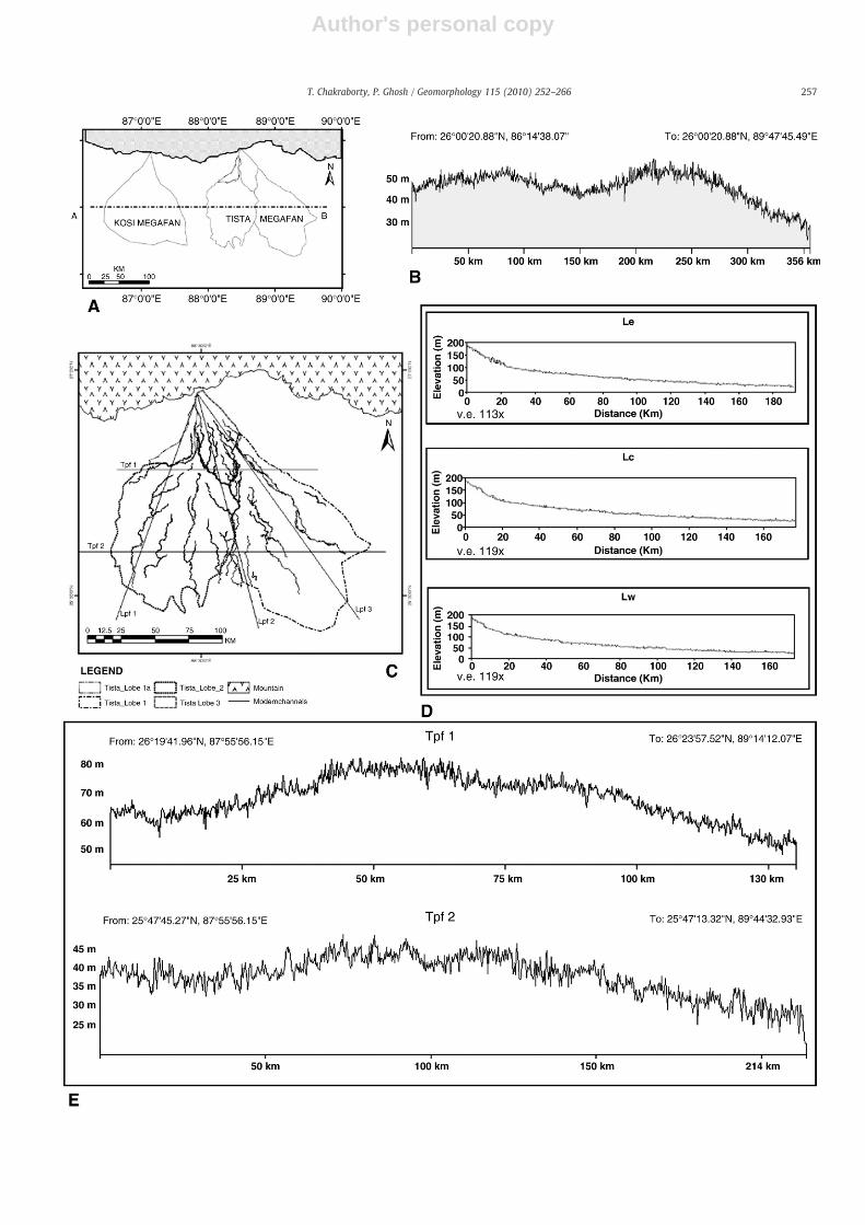
Fig. 1. A generalised map showing the Tista and Kosi megafans and the associated major drainages in the sub-Himalayan alluvial plain. Inset is a GTOPO30 view of the Himalayanorogenic belt and the flanking Ganga–Brahmaputra foreland basin (stippled). The rectangle marks the study area. ‘K’ in the inset marks the city of Kolkata. Note the lobes of the Tistamegafan marked as 1, 1a, 2, and 3. SIL = Siliguri; JAL = Jalpaiguri; KMF = Kosi megafan; Mh = Mahananda River ; B = marks the basement spurs at the southern margin of themegafan.
253T. Chakraborty, P. Ghosh / Geomorphology 115 (2010) 252–266

Author's personal copy
Himalayan foreland basin. These huge cone-shaped sediment bodieshave subsequently been referred to as megafans (Gohain and Prakash,1990; Sinha and Friend, 1994).
The modern foreland alluvial plain formed around 2.0 Ma in res-ponse to the uplift and folding of the Siwalik Group of rocks due tomovement along Main Frontal Thrust (MFT) (Powers et al., 1998;Wesnousky et al., 1999). Quaternary sediments in the easternHimalayan foothills unconformably overlie the Siwalik Group ofrocks and older metamorphic units like Daling Group or DarjeelingGneiss near the mountain front (Acharrya and Shastry, 1979). In thesouthern margin of the foreland the sediments overlie eitherPrecambrian basement rocks or Mesozoic Rajmahal basic volcanicsof the Peninsular India (Dasgupta et al., 2000).
Three distinct groups of Quaternary sediments occur in the easternHimalayan foreland in the Darjeeling and Jalpaiguri districts of WestBengal, India. These are: (a) coarse gravely piedmont sediments lyingclose to themountain front and at places extending few kilometers insidethe mountain valleys; (b) pebbly, coarse to fine sand and mud related tothemegafans and (c) gravel, sand and clay deposited in themodern rivervalleys (Shukla et al., 2001;Ghoshet al., 2005). So far there is nopublishedage data for the Tista megafan deposits, but similar surfaces of the Gangamegafan occurring further west, have a Late Pleistocene to Holocene age(Shukla et al., 2001). In the absence of chronometric data, we have used
conventional criterion like stratigraphic relationship, colour, consolida-tion, soil character etc. to determine the relative ages of differentmegafanunits.
3. Geomorphology
The Tista megafan is a large triangular sediment body characterisedby a radiating drainage pattern (Fig. 2). The apex of the megafancoincides with the point of emergence of Tista River from themountainbelt. Themegafan spreads over India and Bangladesh covering an area ofabout 18,000 km2. The megafan is bounded by the Mahananda River tothe west and its eastern margin broadly coincides with the River Tista(Fig. 1). These rivers are foothills- andmountain-fed respectively (sensuSinha and Friend, 1994). Besides the Tista andMahanandaRivers, a largenumber of streams traverse the megafan. From east to west, theimportant modern rivers include Karatoya, Atrai, Punarbhaba, Tangon,Kulik and Nagar (Fig. 3). These rivers are plains-fed type, havingsignificantly lower discharge compared to foothills- or hinterland-fedrivers. Satellite images display a large number of paleochannels thatform a radial network on the megafan (Figs. 2 and 3).
An east–west cross profile drawn through the central part of theadjacent Kosi and Tista megafans displays convex-up shapes of both themegafan bodies (Fig. 4). Along this cross profile the Tista megafan has a
Fig. 2. Satellite image of Tista megafan. Note radiating drainage pattern of paleochannel belts on the megafan and narrower present-day plains-fed rivers. Rose diagrams, markedwith 1, 2, 3 etc., show the paleoflow pattern measured from the near-surface deposits. In rose 12b, the grey coloured petals display dip data from lateral accretion surfaces (N=9).White lines mark the lobes and the dark line represents the India–Bangladesh border of this area.
254 T. Chakraborty, P. Ghosh / Geomorphology 115 (2010) 252–266

Author's personal copy
higher elevation than the adjacent Kosi megafan, and in the map view,the Tista megafan is larger in area than the Kosi megafan (Figs. 1 and 4).The highest point of the Tista megafan is more than 150 m above theBrahmaputra alluvial plain. Highest slope of the megafan surfaceobserved near its apex is about 0.19° that declines to 0.01° near its toeand the average slope calculated over the entire length of themegafan isabout0.05° (Fig. 4). Theeast–west oriented transverseprofiles showthatthe eastern flankof themegafan is steeper than itswestern flank and themaximum cross profile slope is about 0.01° (Fig. 4). In a series of crossprofiles drawn from north to south, the megafan shows progressivedecrease in elevation and increase in width towards south (Fig. 4).Althoughbroadly convexupward in transverseprofile, theTistamegafansurface is more complex and shows multiple, convex-upward segmentsin some of these profiles (Fig. 4). All the longitudinal profiles areconcave-up, similar to fluvial fans (cf., Whipple et al., 1998; Densmoreet al., 2007).
The gauge station at Anderson Bridge, located nearly 75 km down-stream of the point of exit of the Tista River from the mountain front,documents the average annual discharge between 1965 and 1971 asabout 609 m3/s (http://www.sage.wisc.edu/riverdata/scripts/station_ta-ble.php?qual=32&filenum=2567). Average monthly discharges duringmonsoon months exceed 2000 m3/s (Basu and Sarkar, 1990). It has beenestimated that peak discharge in Tista during 1968 devastating floodof Jalpaiguri Town, ~45 km downstream of the mountain front (Fig. 1)exceeded 19,000 m3/s (http://www.kalpavriksh.org/f1/f1.3/ed%20ecolo-gist%20folder/Teesta-KalyanRudra.doc). In comparison, observed peakdischarge in the Punarbhaba, one of the plains-fed rivers, is reported to beabout 850 m3/s in South Dinajpur District of West Bengal, India (http://ddinajpur.nic.in/Flood_Management/flood_management.html ).
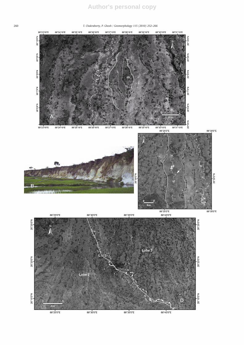
Themodernplains-fed rivers that traverse themegafan have ahighersinuosity and lower width as compared to the paleochannels visible inthe satellite images (Figs. 2 and 3). The sinuosity of modern channelsvaries from1.05 to>3.5,whereas that of the ancient channels vary from1.49 to 1.11 andhave amean value slightly greater than1.1. Thewidth ofthe abandoned paleochannels on Tista megafan ranges between 0.1 and3.3 kmwith a mean of ~1 km. The present-day plains-fed channels varyin width from 30 to 250 m (Fig. 5). There is a noticeable increase insinuosity of both modern and ancient channels down the megafan(Figs. 2 and 3). Most of the plains-fed modern rivers are entrenchedwithin the megafan surface and many of them are underfit relative tothe existing channel morphology (Fig. 6A, B). In contrast, the widerpaleochannels in places show relict mid-channel bars, and thebranching-rejoining patterns that characterise braided river tracts(Fig. 6A).
One of the remarkable features of the Tistamegafan is itsmulti-lobatecharacter (Figs. 2 and 3). In plan, each of the lobes is characterised by aradial drainage pattern and is clearly identified by discordance of channelpatterns in adjacent lobes (Figs. 2, 3, and 6D). In some of the cross profilesthis multi-lobate character is discernable in the form of laterally stackedmultiple convex-up segments (Profiles Tpf 1 and 2, Fig. 4). The smallestlobe, lobe 3, occurs at the northern margin of the megafan body whereaslobes 1 and 2 occur in the southern part. An isolated, small lobe in thenorthwestern corner of the megafan has been marked as lobe 1a (Figs. 2and 3). The apex of radiating paleochannels of lobe 2, themost prominentlobe seen in satellite images, lies about 40 km south of the present-daymountain front as feeder system incises through lobe 1a (Figs. 2 and 3).Each of the trunk channels in the megafan is associated with a numbercrevasse channels in their downstream part developing an anastomosing
Fig. 3. Line drawing of Tista megafan showing ancient channels belts and modern channels traced from satellite images. Also shown are lobe boundaries, large marsh bodies on themegafan surfaces and the locations of sedimentological logs displayed in Fig. 8. Major plains-fed channels referred in the text are marked on the diagram.
255T. Chakraborty, P. Ghosh / Geomorphology 115 (2010) 252–266

Author's personal copy
network. The radiallydisposed trunkchannels and their crevasse channelscombine to produce a maze of channels on the megafan surface (Fig. 2).
The greater width and decreased sinuosity of the paleochannels seenon the megafan surface, and existence of relict braided channel patternsin some of them, indicate that wider braided streams with greaterdischarges and sediment loads were once active on the megafan. Thewidths and plan form of some of the paleochannels are comparable tothe modern Mahananda or Tista Rivers. The relatively narrow, moresinuous, incised and underfit nature of the modern plains-fed channelsimply lower discharge and reduced sediment loads in these channels (cf.Sinha and Friend, 1994). It is evident that the part of the megafanshowing the braided paleochannels accreted in a period when largerchannels forming a radiating network traversed the fan. These channelsare nowabandoned. Themodernplains-fed channels occupy a small partof the abandoned channel tracts and are passively reworking the surfaceof themegafan rather than actively building it (Fig. 6A, C). The truncatingrelationship of the channels observed in satellite images (Fig. 6D) andelevations observed in cross profiles derived fromDEM(Fig. 4e) appearsto indicate that lobe 3 overlies the other lobes and is probably theyoungest one. The lobe 2 drainages cut across thedrainages of lobe 1 andlobe1a implying lobe 2 to be relatively younger than lobes 1 and1a. Lobe1a of the megafan, though older than lobe 2, its temporal relationshipwith lobe 1 cannot be directly established.
The Tista megafan surface, as compared to alluvial fans, has a verygentle slope (<0.19° or 0.0033). However, convex-up cross profile andconcave-up radial profile of the megafan resemble many fluvial fans(Nemec and Postma, 1993;Whipple et al., 1998; Densmore et al., 2007).Existence of radial lobes on the megafan surface resembles similarfeatures observed in typical high-gradient alluvial fans (Bull, 1977) aswell as those reported from someof themodern deep-sea fans (Damuthet al., 1988). Similar multi-lobate form is also present in model fansproduced in the laboratory (Whipple et al., 1998) or those developedthrough numerical simulations (Densmore et al., 2007). Multi-lobategeometry ofmegafans, as in Tistamegafan, is also evident in a number ofother megafans including Taquari megafan of Brazil (Assine, 2005), RioPilcomayomegafan of Argentina (Horton andDeCelles, 2001;Wilkinsonet al., 2006) and Zambezi megafan spread over Zambia and Angola asobserved in landsat images.
3.1. Historical maps and the changing drainage of the area
We examined a number of historical maps of this area publishedbetween1794and1945 andcompared them to recent satellite images tounderstand the possible nature of changes in drainage on the megafanover the historical period. For the purpose of comparison, all maps wereconverted to a common geodetic map projection that uses WGS 84datum.Due to inherenterrors in thesemaps, comparisons arenot alwaysaccurate, although several important features are clear: A radiatingchannel pattern comprising (from west to east) the Tangan, Atrai, andKaratoya on themegafan has been shown prominently in all thesemaps(Fig. 7).Many of themaps published prior to the late eighteenth or earlypart of the nineteenth century, show that this radiating drainage wasdirectly connected to hinterland catchment basins of the Darjeeling–Sikkim Himalaya (Fig. 7; Rennel, 1794; Arrowsmith, 1804; Carry, 1811).In a number of thesemapspublishedprior to themidnineteenth centurythe present-day course of Tista River has been shown as a small plains-fed channel draining into theBrahmaputra River (Fig. 7; see alsoBristow,1999, his Fig. 1). These maps show that rivers of the radiating networkcomprising the Tangan, Punarbhaba, Atrai and Karatoya were tributaryto the Ganges rather than the Brahmaputra River. The maps publishedafter the middle of the nineteenth century on the other hand, show the
hinterland catchments of Darjeeling–Sikkim Himalaya to be drainingthrough the present-day course of the Tista into the Brahmaputra River.In these later maps radiating drainage comprising the Tangan, Atraiand Karatoya is shown as plains-fed, not connected to the Himalayanscatchment basins (Arrowsmith, 1844; Radefeld, 1860; EdinburghGeographical Institute, 1893; Survey of India, 1917; 1924; Fig. 7).Some of the maps of late nineteenth century indicate increasingimportance of the modern course of Tista at the cost of Tangon orPurnarbhaba (Arrowsmith, 1844;Radefeld, 1860). TheMahanandaRiverhas occupied more or less the same position in various maps since thelate eighteenth century albeit therewas aminor shift to thewest duringthis period.
Archaeological sites recording remnants of ancient human settle-ments are common in this area (Hunter, 1876; Goswami, 1948; Ray,1980; Chakrabarti, 2001). It appears from the historical as well asarchaeological records that during the entire period of 3rd Century BC to11th Century AD, all the courses of the radiating network of Karatoya–Atrai–Punarbhaba–Tangon Rivers existed as large navigable channels. Ithas been reported that in a major flood in 1787 the hinterland drainageoutlet avulsed into the present-day course of River Tista abandoning thenetwork of Tangan–Atrai–Karatoya (Hunter, 1876; Ray, 1980). Thisdescription tallies well with the observation from old maps. In tandemwith thehistorical accountofHunter (1876),most of themapspublishedaround or after 1850 show upland Himalayan catchment to feedBrahmaputra River through the course of present-day Tista. Evolution ofthe drainage pattern outlined above suggests that the radiating drainagesystem comprising Karatoya–Atrai–Punarbhaba–Tangon fed by theHimalayan catchment was probably responsible for aggradation of apart of the Tista megafan. Some of the wide, braided paleochannelsrecognisedon themegafanareprobably the recordolddrainage systems.The present-day narrow, sinuous, underfit and incised nature ofmany ofthese river channels is probably the result of decreased sediment andwater discharge after their detachment from the Himalayan catchment.
4. Sedimentology
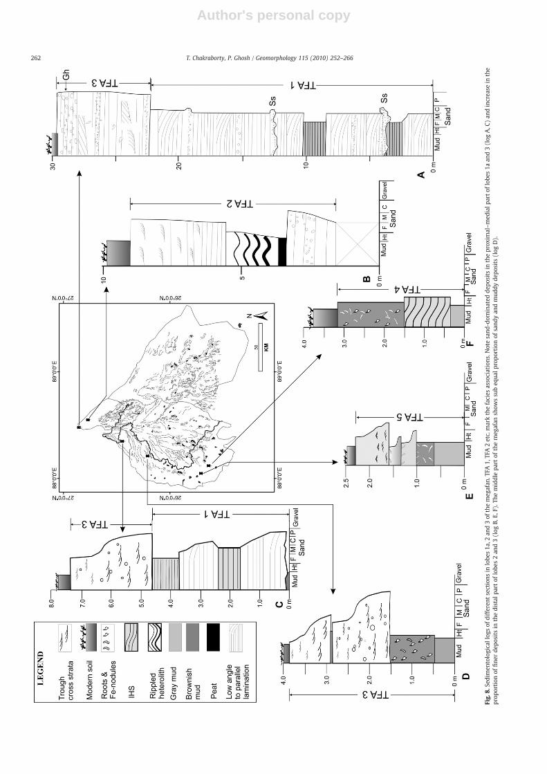
Sedimentation pattern of Tista megafan was studied in 6–35m thickriverbank sections of some of the incised channels. The representativelithologs of the studied sections are given in Fig. 8. Since the fieldworkwas confinedwithin Indian part of themegafan, a large part of lobe1 andlobe 2, lying within Bangladesh, could not be studied (see Fig. 2). Detailinvestigation of the sedimentology of themegafan is beyond the scope ofthis publication and the following section deals with the first orderfeatures of sedimentary facies of the Tista megafan deposits. Weparticularly emphasise on the proximal–distal relationship in themegafan sediments as observed in lobes 1a, 2 and 3. Eight major facieswere defined following the scheme suggested by Miall (1996) in thenear-surface deposit of the Tista megafan, and is summarised in Table 1.These facies have been grouped into five major facies associations(Table 2). Main attributes of each facies associations and the inferredenvironments are discussed in the following section.
4.1. TFA 1
The facies association is well-developed in the proximal part of lobes1a, 2, and3, and comprises dominantly of planar, horizontal to low-anglestratified sand (Sh, Fig. 9A). 50–90 cm thick units of this associationusually begin with basal erosion surface strewn with coarse to pebblysand and mudclasts (Ss). The erosion surfaces are overlain by sets ofhorizontal or low-angle stratification, which in turn grade upwards intobeds of silt and clay-rich very fine sand (Fsm). At places, up to 15 cm
Fig. 4. a: Diagram showing the outline of Tista and Kosi megafans and location of the line of transverse profile (line A–B) as shown in b. b. Cross profiles drawn through Kosi and Tistamegafans from SRTM data. Along the profile line, the highest point of the Tistamegafan is at higher elevation than the Kosi megafan. c. Outline diagram showing themodern channelsand lobes on the Tista megafan, and the lines of transverse (Tpf 1 and Tpf2) and longitudinal (Le, Lc, Lw) profiles shown in d. d. Three longitudinal profiles along the east, centre andwest of the megafan. Note high vertical exaggeration due to low overall slope. e. Two transverse profiles across the Tista megafan. Note laterally stacked, smaller, convex-upsegments in the cross profile superposed on a broad convex-up megafan surface.
256 T. Chakraborty, P. Ghosh / Geomorphology 115 (2010) 252–266
Author's personal copy
257T. Chakraborty, P. Ghosh / Geomorphology 115 (2010) 252–266

Author's personal copy
thick shallow scour-fills of medium to coarse sand occur at the top ofthese units (Fig. 9A). Locally, planar cross sets with sigmoidal foresets(Sp), up to 50 cmthick, occur in pebbly sand layers. The individual sets ofhorizontal strata can be traced laterally for >15 m and the individualsmall-scale fining upward units extend several tens of meters acrossthe entire outcrop. In the Tista River section (lobe 3), this associationexposed in a 35 m river bank cliff, shows a distinct coarsening-upwardtrend as parallel and cross-stratified pebbly coarse sand and sandygravel dominate the top-most part of the section (log A, Figs. 8 and 9B).Measurements from associated cross-strata in lobe 3 exposures showpaleocurrent, varying between southwest and southeast (rose 2, 3, 5,Fig. 2).
We infer the 50–90 cm thick, fining upward units to represent theproduct of a system of unconfined, high-energy sandy streamscharacterised by flashy flood discharge and rapidly deceleratingflow. Overwhelming dominance of parallel stratification indicatesboth high flow velocity as well as availability of sandy sediments. Theshallow channel fills at the top of individual units formed during low-stage flow, as decelerating sheet flow collected into few shallowchannels/reels. McKee et al. (1967) and Tunbridge (1981) respec-tively, have documented typical modern and ancient examples of thistype of sheet-braided sandy stream deposits. The planar cross-stratawith sigmoidal foresets probably denote local development ofhumpback dunes or simple cross-stratified bars that formed underflow condition transitional to upper-phase plane beds (Saunderson andLockett, 1983; Allen, 1983; Fielding, 2006). The distinct coarsening-upwards trend, as noted in the proximal part of lobe 3, appears to belinked to the progradation of themegafan lobe. The paleoflowpattern isconsistent with a southward radiating paleochannel network.
4.2. TFA 2
The association occurs in the distal or marginal part of lobe 3 andcomprises 1–3 m thick parallel and small cross-stratified medium tofine sand (St, Sh) alternating with 1.2–2 m thick dark clay–siltheterolithic layers (Fsm; log b, Fig. 8). At places dark brown to blackpeat layers, 10–20 cm thick, occur below the silt–clay units. Wave orcombined flow ripples are common in silt layers; and small troughcross-strata of sand units measured from the downstream or lateralpart of lobe 3 show mean paleoflow towards 233° and towards 152 °(rose 4 and 1, Fig. 2).
Abundance of trough cross-strata compared to the dominance ofhorizontal strata in TFA1, indicates flow deceleration in the distal ormarginal parts of lobe 3. Silt–clay heterolith and peat layers representthe development of marshy environment in the distal part of thesheet-braided streams of TFA 1. Wave ripples formed in the standing
water body of marshes and thick vegetal growth resulted in peat andcarbonaceous clay layers. The facies association is inferred to indicatelow-gradient alluvial plain typified by gentler flowing streams andflanking marshes.
4.3. TFA3
The facies association comprises stacked, 1–1.5 m thick, troughand planar cross-stratified (Sp, St) pebbly coarse sand and horizon-tally stratified medium sand (Sh) units (Fig. 8). The facies common inthe medial part of lobes 1a and 2 (Fig. 8, logs C and D). Usually 10–15 cm thick pebbly sand occurs associatedwith erosive base of each ofthe units (Ss). Parallel-stratified sandy gravels (Gh), up to 35 cm thick,also occur locally in the basal part of the facies association. In most ofthe exposures 5–20 cm thick trough cross-strata is the dominantstructure. Half-a-meter-scale planar cross-strata and soft sedimentdeformations are observed at places. The sand is grey to yellowishbrown with dark ferruginous blotches. Individual sand bodies of thisassociation can be laterally traced for more than hundred meterswithout perceptible change in their thickness (Figs. 6B and 9C). Thesand bodies generally lack fining upwards grain size trend, althoughsome of the exposures display poorly developed fining upwards trend.In a few outcrops, a sharp contact separates sand units from over- orunderlying, up to 2 m thick, red or grey clay/mud units (Fsm, Fpr).
Coarser grain size (as compared to TFA1 and TFA4), tabulargeometry of the sand bodies, absence or poorly developed finingupwards grain size trend within sand bodies, locally developed basalgravelly units, and absence of lateral accretion surfaces possiblyindicate deposition from low-sinuosity streams capable of carryinggravelly or coarse sandy load during flood stage. This interpretation isconsistent with remnant braided bars recognised in the paleochannelsseen in the satellite images in the proximal part of lobe 2 (Fig. 6A). Thesharp contact of sand bodies with over- or underlying fines is inferredto result from rapid channel abandonment (Collinson, 1996). Grey ordeep brown mud with iron-rich nodules represents floodplaindeposits and soil development in the over bank areas of the sandy,low-sinuosity streams (cf. Bentham et al., 1993).
4.4. TFA 4
This facies association comprises 1.5–3 m thick fining upwardunits with well-developed Inclined Heterolithic Strata (IHS; Fig. 8, logF; Fig. 9D). This facies association is common in the distal part of lobe2. The hereolithic strata comprise an alternation of 7–32 cm thicktrough cross-stratified fine to medium sand (St) and 3–11 cm thickred mud/clay layers. The sand bed thickness decreases upwards in the
Fig. 5. Histogram showing the widths of the modern plains-fed channels and paleochannels seen on the satellite images (see Fig. 2).
258 T. Chakraborty, P. Ghosh / Geomorphology 115 (2010) 252–266

Author's personal copy
units with concomitant increase of fines. Overall flow directionsmeasured from trough cross-strata of the sand layers are towards269° whereas the inclined surfaces (IHS) dip either to the north-northwest or to the south-southeast (rose 12a, b). The IHS units areoverlain in some sections by 1.5 m thick iron nodule rich red mud orthinly layered grey mud (Fsm. Fpr; Fig. 8, log F).
High angle relationship between the mean flow direction measuredfrom trough cross-strata and dip of the inclined heterolithic strataidentifies these features as lateral accretion architectural elements(sensu Miall, 1996). Overall finer grain size and increased proportion ofmud in this facies association together with well-developed finingupward trend and presence of lateral accretion elements indicatedeposition of this association from mixed-load meandering streams(Collinson, 1996; Rajchl and Ulycny, 2005).
4.5. TFA 5
This facies association is characterised by up to 2.5 m thick units ofdark grey, carbonaceous mud with interlayered clayey silt layers(Fsm, Fpr; Fig. 8E). Brick kiln pits, common in the distal part of lobe 2,expose large, three-dimensional bodies of this facies. Tabular, 30–70 cm thick, clayey silt beds of TFA 5, are internally rippled, have asharp base and can be traced laterally for few hundredmeters. Withinthis clay-dominated facies association, there are at least three 15–25 cm thick zones that show intense root turbation and iron-encrusted root moulds (Fig. 9E).
Grey colour and carbonaceous nature of the fine-grained unitsindicate their accumulation in an area of shallow water table andabundant vegetation typical of mashes in the flood plains of the distalpart of the megafans (cf. Gohain and Prakash, 1990; Horton andDeCelles, 2001). The tabular rippled clayey silt beds probablyrepresent crevasse lobes encroaching into these floodplain lakes (cf.Perez-Arlucia and Smith, 1999). The iron-encrusted root-beds implythe development of gleyed paleosol (Duchaufour, 1982). Three-dimensional extent of these clay-dominated units, as could beassessed from the brickfield quarries, indicates large spatial extentof these marshes. In the satellite images, recognition of large wetlandsin the distal part of the Tista megafan is consistent with theoccurrences of extensive units of TFA 5 in the distal part of lobe 2.
In Fig. 2, rose diagrams superposed on a mosaic of satellite imagesshow the paleodispersal pattern documented from the near-surfaceTista megafan deposits of the study area. A radiating southwardpaleocurrent pattern is evident in lobe 3. A south-to-southwesterlypaleoflow recorded from lobes 1a and 2 is consistent with the observedsouth to southwesterly radiating paleochannels of the study area.
Thus, generalised facies character of the near-surface exposuresstudied in lobes 1a, 2 and 3 of the Tista megafan is typified by theproximal–distal transition fromproximal deposits of sandy sheet-braidedstreams to mixed-load, low-energy, sinuous channel deposits andassociated floodplain marsh deposits in the distal part of the megafan.Braided river deposits of TFA 3with uncommon but thick over bank finesand soils typify intermediate part of themegafan (log D, Fig. 8). However,we couldnotmap the regional distributionof the facies as large part of themegafan occurs within Bangladesh and has not been studied. Further, thepaleo-marsh deposits of TFA 5, is likely to be patchy and difficult to mapwith limited outcrops. However, the first order features noted in thestudied exposure are consistentwith the observedgeomorphic features ofthe megafan. Radial to southwestward diverging paleocurrent pattern isconsistent with paleochannel traces seen in the study area and theradiating pattern reflects the convex-upward three-dimensional mor-phology of themegafan. The changes in the channel type and reduction inthe grain size of the sediments showdecreasing transport efficiency of thechannels down the megafan and it appears to be the response to thesouthward decrease in the gradient of the megafan surface. Thecoarsening-upward trend of the deposits in the proximal part of lobe 3possibly indicates progradation of the fan lobe. Similar facies pattern has
been reported from the modern and ancient megafan deposits (Singhet al., 1993; Horton and DeCelles, 2001; Shukla et al., 2001). In contrast totheothermegafandeposits described fromGangaPlain (Singhet al., 1993;Shukla et al., 2001) gravelly deposits are virtually absent in the Tistamegafan. Similar gravel-free sand- and mud-dominated megafan sedi-ments have, however, been recorded from sub-Andean CamargoFormation of Tertiary age (Horton and Decelles, 2001).
5. Depositional dynamics of the Tista Megafan
Two braided low-sinuosity rivers flank the Tista megafan today,the mountain-fed Tista River, and the foothills-fed Mahananda River.Majority of the presently active channels on the fan surface are plains-fed type. These rivers, fed by ground water and surface run off, arenarrower, at places entrenched deeply within megafan deposits, andshow much higher sinuosity than either that of the hinterlandcatchment-fed rivers or that of the paleochannels recognised on thefan surface. The features of the plains-fed streams, particularly theirunderfit, incised nature, reflect a decreased sediment and waterdischarge (cf. Sinha and Friend, 1994). The paleochannels, in general,have greater widths and lower sinuosity compared to the modernplains-fed channels (Figs. 2, 3, and 5). Relict mid-channel bars andbraided patterns are recognised in the proximal part of somepaleochannels of lobe 2 (Fig. 6A). The upstream reaches of thesepaleochannels are comparable to the size and plan form of modernTista or Mahananda River. Some of the historical maps as well asarchaeological data imply that a radial drainage system comprisingTangan–Atrai–Karatoya once formed large navigable channels direct-ly connected to the Himalayan catchment. Collectively these observa-tions would imply the following: i) During the active aggradation ofthe Tista megafan possibly much wider braided streams fed by largeHimalayan catchments traversed this area. ii) These channels and themegafan have largely been abandoned. The Tista River situated on theeastern margin of the megafan drains the upland catchment basintoday, and incises up to 35 m into the megafan deposits of lobe 3. Theradial paleodrainage consisting of Tangan–Atrai–Karatoya is nowdetached from the Himalayan catchments, and like other plains-fedchannels is presently incising and reworking the top of the megafandeposits. iii) The paleochannels, as evident from the satellite imagesand the near-surface sedimentary deposits, were low sinuosity; sandybraided ones near the megafan apex. In the downstream areas, thesinuosity of these channels increased and their sediment load becamefiner. Floodplain lakes or marshes were common in the distal part ofthe lobes. Such proximal–distal changes in the paleochannel patternand its deposits are attributable to decreased slope down theprecursor Tista megafan surface.
The observed radiating paleochannel pattern appears to be thecombined effect of nodal avulsion of the main channels in theupstream reach and crevasse channel formation in the distal megafanregion. Development of crevasses in the downstream part isconsistent with increased channel aggradation rate in bank-confinedsinuous rivers and is probably reflective of a decreased channelgradient (cf. Mackay and Bridge, 1995; Assine, 2005).
Development of radial sediment lobes and relocation of the trunkchannels from the apex are common features in most of the megafansor similar depositional features (Horton and Decelles, 2001; Assine,2005; Nichols and Fisher, 2007). The existence of radial depositionallobes is also documented from debris-flow dominated or braidedstream constructed small, high-gradient, alluvial fans (Bull, 1977;Hubert and Filipov, 1989; Nemec and Postma, 1993). Radial, multi-lobate geometry also characterises many sandy deep-sea fans(Damuth et al., 1988; Reading and Richards, 1994). The sub-aerialfans produced in the laboratory or through numerical simulation alsoshow similar multi-lobate form (Whipple et al., 1998; Leeder, 1999;Densmore et al., 2007; Karssenberg and Bridge, 2008). In all thesecases fixed channel outlet at the basin margin, lateral unconfinement
259T. Chakraborty, P. Ghosh / Geomorphology 115 (2010) 252–266
Author's personal copy
260 T. Chakraborty, P. Ghosh / Geomorphology 115 (2010) 252–266

Author's personal copy
of the feeder channel as it enters the aggradational basin, highgradient and high sediment load of the main channels appear tocontrol the development of these fan-shaped sediment bodiesthrough random nodal avulsion. The entire surface of the fan-shapedsediment bodies is rarely flooded and deposition at a particular time isconfined to a single accretionary lobe. Deposition in a lobe pro-gressively reduces its gradient effecting relocation of the sedimentconduit through a nodal avulsion to a site with more favourablegradient. Repetition of this process results in the formation of a fan-shaped sediment body with radial lobes (Schumm et al., 1987;Whipple et al., 1998; Horton and DeCelles, 2001).
A spectrum of sizes, gradients and the depositional processes hasbeen reported from these fan-shaped sediment bodies. Depositionalprocesses operative on these conical, fan-shaped sediment bodiesdiffer significantly in different settings and include sub-aerial debrisflow, supercritical sheet flood, turbidity current and fluid-gravityflow. Notwithstanding the difference in depositional processes, sizeand slope, all these point-sourced conical sediment bodies (fans,megafans, fluvial distributary systems or deep-sea fans) generallyshare certain common features as discussed above. Occurrence ofthese features in the Tista megafan implies similar system-scalecontrols on the development of this megafan. It is generallyaccepted that there is a complete gradation in the size, slope,sediment load and depositional processes operative on the fan-shaped sediment bodies (cf., Stanistreet and McCarthy, 1993;Nemec and Postma, 1993; Leeder, 1999; Saito and Oguchi, 2005;Hartley et al., 2009). Although occurring at the low-gradient, fine-grained end of a spectrum of conical sediment bodies (cf. Fig. 3 ofBlair and McPherson, 1994), the geomorphic features of the Tistamegafan outlined above strengthens, the notion of classifyingmegafans in the ‘alluvial fan spectrum’. Although made up entirelyof fluvial deposits, megafans as a whole display a distinctive convex-upward cross profile, concave radial profile and radial drainage patternin contrast to concave-upward cross profiles of the rivers and subparallel
orientation of channel network in the alluvial plains (Blair andMcPherson, 1994, their Fig. 2). The morphology and sedimentology ofthe Tistamegafan, appear to bemore congruentwith the classification ofalluvial fan spectrum proposed by Stanistreet and McCarthy (1993). Inthe triangular plot of fan-shaped sedimentary bodies, Stanistreet andMcCarthy (1993) proposed, that the debris-flow dominated fans formone end member, the large fan-shaped bodies constructed by braidedrivers and low sinuosity/meandering rivers form the other two end-members of the spectrum.
Compared to the postulated continuous, unidirectional shift of thetrunk channel across the surface of the Kosi megafan (Mukherjea andAich, 1963; Gole and Chitale, 1966;Wells and Dorr, 1987; Singh, 1994),the Tista megafan shows multi-lobate geometry with random lobeswitching through nodal avulsions. A convincing reason for unidirec-tional, westward shift of the Kosi River across the megafan surface,particularly up the slope on the eastern half, and the relationship of suchthismigrationwith building of the Kosimegafan remains elusive (Wellsand Dorr, 1987; Mackay and Bridge, 1995). The latest computersimulation of alluvial systems similar to Kosi megafan has failed tosimulate a progressive shift of the channel in one particular directionacross a growing fan (Karssenberg and Bridge, 2008; Bridge, personalcommunication). The megafan studies by earlier workers, on the otherhand, appear to demonstrate that unconfinement of the trunk river atthe mountain front, high sediment input and pronounced dischargefluctuations exerts a more fundamental control onmegafan building byfavouring rapid sedimentation and repeated nodal channel avulsion(Gupta, 1997; Horton and DeCelles, 2001; Leier et al., 2005; Hartley etal., 2009).
6. Conclusions
1. The Tistamegafan of themodern sub-Himalayan foreland basin has asurface area of about 18,000 km2, and is characterised by a radialdrainage pattern, a convex-upward cross profile and concave-
Fig. 6. A. Satellite image showing the close-up of abandoned channel belts on the proximal part of lobe2. Note braided pattern of the channels and a mid-channel bar (m)recognisable on the image. Note narrow, highly sinuous modern plains-fed channels on the left side of the mid-channel bar. IRS PAN Image. B. Field photograph showing entrenchedBerang River (26°26′27.76″N; 88°21′19.87″E) in lobe 1a. Note about 10 m of incision of the modern Berang River. Amalgamated sheet-like sand bodies occur in the bank, the detailsshown in Fig. 9C. C. Underfit modern stream (arrowed) occupies the central position of a paleochannel belt (dashed lines) on the lobe 2. D. Contact between lobe 2 and lobe 3 of theTista megafan. Note drainage discordance across the separating channel between two adjacent lobes. Dotted line marks the boundary between the lobes.
Fig. 7. Major drainages traced from three old maps. Arrowsmith, 1804: Tangan–Atrai–Karatoya directly connected to the Himalayan catchments and draining into Ganges. Noteplains-fed nature of Tista River occurring as a small tributary of Brahmaputra; Carry (1811): Tangan–Atrai–Karatoya trio hinterland-fed. Note hinterland-fed Kosi and plains-fed TistaRivers; Survey of India (1917): hinterland-fed Tista and plains-fed Tangan–Atrai–Karatoya.
261T. Chakraborty, P. Ghosh / Geomorphology 115 (2010) 252–266
Author's personal copy
Fig.
8.Se
dimen
tologicallog
sof
differen
tsections
inlobe
s1a
,2an
d3of
themeg
afan
.TFA
1,TF
A2etc.markthefacies
associations
.Notesand
-dom
inated
depo
sits
intheprox
imal–med
ialp
artof
lobe
s1a
and3(log
A,C
)an
dincrea
sein
the
prop
ortion
offine
rde
posits
inthedistal
part
oflobe
s2an
d3(log
B,E,
F).T
hemiddlepa
rtof
themeg
afan
show
ssu
beq
ualp
ropo
rtionof
sand
yan
dmud
dyde
posits
(log
D).
262 T. Chakraborty, P. Ghosh / Geomorphology 115 (2010) 252–266

Author's personal copy
Table 2Facies associations of Tista megafan.
Faciesassociation
Facies Description and occurrence Paleocurrent Interpretation
TFA1 Sh (dominant), Sp, St andrare Gh
Erosively based, 50–90 cm units laterally traceablefor more than 15 m; horizontal to low-angle stratagrading upward into 10–30 cm muddy silt; rareplanar cross-beds and shallow channel fills; 35 msuccession in the Tista River shows a coarsening-upward trend; occurrence in the proximal part oflobes 2 and 3.
Varying between126° and 210°
Unconfined sandy braided stream with flashydischarge and sandy bed load.
TFA 2 St, Sh, Fsm Up to 3 m thick horizontal or cross-stratified sandunits alternate with 15–200 cm thick mud, siltlayers with wave and current ripples; thin peatlayers at places; common in western and southernmargins of lobe 3 and in the medial to distal part oflobe 2.
Mean direction westto southwest
Distal part of the sheet-braided fluvial system lowerflow velocity and development of floodplain; waverippled silt–mud and peats accumulated infloodplain ponds or marshes
TFA 3 St, Sp and Gh (rare)+Fsm, Fpr 1–1.5 m thick, erosively based, coarse, pebbly sandbodies, locally fining upward; horizontal strata,trough cross-strata (5–20 cm) dominates; planarcross-strata (up to 40 cm) also common; fewstratified gravel beds in the basal part of the units;overlain by red or grey mud/clay units, at placeswith iron nodules. Proximal to medial part of lobe 2
Broadly SSW Braided stream deposits. DA elements notrecognised in small exposures but braided barfeatures are identifiable in satellite images ofpaleochannels; floodplain fines and incipient soilspreserved.
TFA 4 St, IHS, Fsm Fpr 1.5–3.0 fining upwards succession, cross-beds atthe base and thick units of fine sand at the top;sand–mud inclined heteroliths comprising 7–32 cmsand layers (with Tg cross-strata) alternating with3–11 cm mud/clay layers; deep red mud with rootmoulds and iron concretions common near top.Common in the distal part of lobe 2
Overall paleoflow toSW (220°);observed IHS diptowards NNW or SSE
Mixed-load, meandering streams with well-developed point bars and floodplain fines; soilprofiles with abundant root structure common
TFA 5 Dominantly Fsm with thin bedsof Fr
2–2.5 m thick dark grey mud and carbonaceous claywith 30–70 cm thick clayey silt beds with ripplelamination; tabular rippled silt beds can be tracedlaterally for few hundreds meters; few 15–25 cmzones marked by the presence of dense rootmoulds; these root zones are marked by Fe-enrichment; common in the distal part of lobe 2
– Large swamp/marsh deposits; clayey rippled bedsare probable crevasse lobes encroaching intomarshes; rooted horizons represent near emergentsurfaces colonized by plants in the marshland.
Table 1Lithofacies of the Tista megafan deposits.
Facies Description Paleocurrent Occurrences Interpretation/remark
Stratifiedsandy pebble gravel (Gh)
Sandy pebble gravel, few cm to 1 m thick, low-angle orhorizontally stratified, imbricated clasts
– At few places in theproximal part of lobe 2and top of lobe 3
Traction transported gravel forminggravel sheets near the channel base(Hein and Walker, 1977)
Horizontal to low-anglestratified fine-coarse sand (Sh)
Mm-scale strata occurring in tabular units, few tens of cmthick; laterally traceable for few meters; at places finesupward.
Low-anglestrata showSE to S-wardflow
Common in theproximal part of lobe 2and over a large part oflobe 3
Deposit of upper regime flow probablythrough migration of very low-amplitude bedforms (Best and Bridge,1992)
Solitary largeplanar cross-beddedmed.-pebbly sand (Sp)
Isolated sets 30–55 cm thick; foresets at places showsigmoid shape; large clasts occur dispersedly, commonlyinterlayer with Sh
Fewmeasurementshow E to SEflow
Common in theproximal part of lobes2 and 3.
Large 2-D dunes; at times subjected totransitional to upper flow regime flowallowing transport of pebbles andformation of humpback dunes(Saunderson and Lockett, 1983)
Small troughcross-stratified med. sand (St)
5–20 cm thick sets, forming decimetre scale cosets Widedispersionbetween Eand SW
Dominant in medial–distal part of lobes 3and 2
Small 3-D dunes
Shallow erosional scours (Ss) 10–25 cm deep, up to 5 m wide scours filled with coarsesand to silty sand; show a F–U trend
Broadly toS-ward
Common in proximalas well as distal part oflobe 3
Shallow channel fills
Rippled or massive silt,mud (Fsm)
Dark grey units up to meter thick;massive or with mm-scale laminae marked by alternationof silt-rich and clay-richlayers; wave and current ripplelaminations common; iron-encrustedroot moulds found locally; atplaces 10–20 cmthick peat layers.
– Common in distal partof lobes 2 and 3
Deposition in overbank stagnantpools/marshes with abundantvegetation; occasionally receiving silt-rich crevasse flow and reworked bywind-generated waves
Inclined heterolithicstrata of sand–silt–mud (IHS)
Up to 2 m thick inclined stratamade up of reddish silt, mud andsand; dip obliqueto flow vectors measured fromunderlying sand (St)
NNW or SSEdip of the IHS
In the distal part oflobe 2
Lateral accretion deposits in mixed-load channels (Thomas et al., 1987)
Brownish red mud withiron-rich nodulesand root moulds (Fpr)
Chocolate brown, tough mud units, 0.25to 1.0 m thick, with abundant iron-richconcretions.
– In the medial to distalpart of lobe 2
Brownish colour, iron-encrusted rootmoulds and nodules formed in the soilprofiles of the megafan surface.
263T. Chakraborty, P. Ghosh / Geomorphology 115 (2010) 252–266

Author's personal copy
Fig. 9. Sedimentary features of Tista megafan. A. Horizontal strata dominated succession in lobe 3, (log A, Fig. 8). Note shallow erosional scour (Ss) and small channel (Ch). B. Pebblygravel and gritty cross-stratified sand near the top of lobe 3 succession, Tista River section (log A, Fig. 8). C. Amalgamated sandy channel-fill deposits of TFA 1, Berang River section.Note sheet-like sand bodies. D. A 1.5 m thick inclined heterolithic strata. Photograph looking to SE, Kulik River section (log F, Fig. 8). Note thicker sandy beds in the lower part anddeceasing bed thickness and increasing mud up section. E. Log of the marsh deposit exposed in the distal part of lobe 2 (log E, Fig. 8). Photograph shows the close-up of iron-encrusted root zones in the carbonaceous mud deposits.
264 T. Chakraborty, P. Ghosh / Geomorphology 115 (2010) 252–266

Author's personal copy
upward radial profiles. The mean radial gradient of the megafansurface is about 0.05° with a maximum of ~0.19° near its apex.
2. Two hinterland catchment-fed large braided streams, namely theTista and the Mahananda Rivers, broadly mark the eastern andwestern margins of the megafan. A network of radial modernchannels traverses themegafan, and these channels, compared to thebraided Tista andMahananda, are narrower,more sinuous, plains-fedtype and are incised on the megafan surfaces.
3. A radial network of paleochannels is recognised on the satellite imagesof the megafan. These paleochannels are wider, less sinuous than themodern plains-fed channels and are comparable to hinterland-fedTista and Mahananda Rivers.
4. Historical maps and archaeological data suggest that until the lateeighteenth century many of these modern plains-fed rivers werelarge navigable channels directly connected to the Himalayancatchments.
5. Three major lobes were recognised on the Tista megafan. The lobesare identified by drainage discordances at their boundaries and theirsubtle expressions in the cross profiles. Each of the lobes ischaracterised by radial modern and ancient drainages and down-the-megafan increase in the channel sinuosity. Large vegetatedmarshes become increasingly common in the distal part of the lobes.
6. Eight facies recognised in the megafan deposits, can be grouped intofive facies associations. Sandy sheet-braided streamdeposits of FaciesAssociations 1 and 3 dominate the proximal to medial part of thelobes; the distal parts of the lobes are characterised by low-energy,sand–mud channel deposits of Facies Association 4. The floodplainmarsh and/or lake deposits of Facies Associations 2 and 5 becomeincreasingly abundant in the distal part of the lobes. The proximal–distal facies pattern and a radial to southwestward divergentpaleoflow observed in the study area are consistent with thegeomorphology of the megafan.
7. Existence of a radial, multi-lobate drainage system, convex-up crossprofile, concave-up radial profile, and a distinct proximal–distal faciestrend recorded from the Tista megafan is similar to the features ofmany other high-gradient alluvial fans. The morphological similaritiesin turn may be indicative of the commonness in certain controllingfactors between these two depositional systems.
8. The relative age of the lobes inferred in this study indicates repeatedandrandomnodal avulsionof themain feeder channel. In comparisonto inferred continuous unidirectional lateral migration of the mainfeeder channel of the Kosi megafan, accretion and growth throughrandom lobe switchingby largemountain-fed streamsappear tohavecontrolled thedevelopment of theTistamegafan. Similarmulti-lobategeometry is common inmany othermegafans throughout the world.
Acknowledgements
Indian Statistical Institute funded this research. We gratefullyacknowledge the help from Rimpal Kar in preparing most of thediagrams and revising them.We appreciate our students, ShyamantakChatterjee, Samarpan Dey, Jayati Paul and Saunak Basu for variousassistances. We are thankful to Bill Dietrich, Leslie Hsu and TrishaChakraborty for extending all possible help in consulting UC, Berkeleymap library. Constructive criticisms and suggestions from reviewersPeter DeCelles, J. A. Fisher, Gary Weissmann and Guest Editor GaryNichols helped in significantly improving our presentation.
References
Acharrya, S.K., Shastry, M.V.A., 1979. Strtigraphy of the eastern Himalaya. Proc. HimalayanGeology Seminar: GSI Miscl. Publ., vol. 41, pp. 49–64.
Allen, J.R.L., 1983. Studies in fluviatile sedimentation: bars, bar-complexes and sandstonesheets (low sinuosity braided streams) in Brownstones (L. Devonian), Wels borders.Sedimentary Geology 33, 237–293.
Arrowsmith, A., 1804. Hindoostan: From Arrowsmith's Map of Asia. David Rumsey DigitalMap Collection. University of California, Berkeley.
Arrowsmith, J., 1844. Map of India. World Atlas. David Rumsey Digital Map Collection.University of California, Berkeley.
Assine, M.R., 2005. River avulsions on the Taquari megafan, Pantanal wetland, Brazil.Geomorphology 70, 357–371.
Basu, S.R., Sarkar, S., 1990. Development of Alluvial Fans in the Foothills of theDarjeeling Himalayas and their Geomorphological and Pedological Character-istics. In: Rachocki, A.H., Church, M. (Eds.), Alluvial Fans: A Field Approach. Wiley,Chichester, pp. 321–333.
Bentham, P.A., Talling, P.J., Burbank, D.W., 1993. Braided Streamand Flood-plainDepositionin a Rapidly Aggrading Basin: The Escanilla Formation, Spanish Pyrenees. In: Best, J.L.,Bristow, C.S. (Eds.), Braided Rivers: Geological Society of London Special Publication,vol. 75, pp. 177–194.
Best, J.L., Bridge, J.S., 1992. The morphology and dynamics of low-amplitude bedwaves uponupper stage plane beds and preservation of planar laminae. Sedimentology 39, 737–752.
Blair, T.C.,McPherson, J.G., 1994. Alluvial fans and theirnatural distinction from rivers basedon morphology, hydraulic processes, sedimentary processes and facies assemblages.Journal of Sedimentary Research A64, 450–489.
Bristow, C., 1999. Gradual Avulsion, River Metamorphosis and Reworking by UnderfitStreams: AModernExample from the Brahmaputra River in Bangladesh and a PossibleAncient Example in the Spanish Pyrenees. In: Smith, N.D., Rogers, J. (Eds.), FluvialSedimentology VI International Association of Sedimentologists Special Publication,vol. 28, pp. 221–230.
Bull, W.B., 1977. The alluvial fan environment. Progress in Physical Geography 1, 222–270.Burbank, D.W., Beck, R.A., Mulder, T., 1996. The Himalayan Foreland Basin. In: Yin, A.,
Harrison, M. (Eds.), The Tectonic Evolution of Asia. Cambridge University Press,Cambridge, pp. 149–188.
Carry, M., 1811. An Accurate Map of Hindostan or India from Best Authorities. DavidRumsey Digital map collection. University of California, Berkeley.
Chakrabarti, D.K., 2001. Mahananda Plains. Archaeological Geography of the Ganga Plain.The Lower and the Middle Ganga. Permanent Black Publishers, Delhi, pp. 58–102.
Collinson, J.D., 1996. Alluvial Sediments. In: Reading, H.G. (Ed.), Sedimentary Environ-ments: Processes, Facies and Stratigraphy. Blackwell Science, Oxford, pp. 37–82.
Damuth, J.E., Flood, R.D., Kowsmann, R.O., Belderson, R.E., Gorini, M.A., 1988. Anatomyand growth pattern of Amazon deep-sea fan as revealed by Long-Range Side-ScanSonar (GLORIA) and high resolution seismic studies. American Association ofPetroleum Geologists Bulletin 72, 885–892.
Dasgupta, S., Pande, P., Ganguly,D., Iqbal, Z., Sanyal, K., Venkatraman,N.V., Dasgupta, S., Sural,B., Harendranath, L., Mazumdar, K., Sanyal, S., Roy, A., Das, L.K., Misra, P.S., Gupta, H.,2000. SikkimHimalaya and Punea Basin, Plate SEISAT 13. In: Nurula, P.L., Acharrya, S.K.,Banerjee, J. (Eds.), Seismotectonic Atlas of India: Kolkata, Geological Survey of India.
Decelles, P.G., Cavazza, W., 1999. A comparison of fluvial megafans in the Cordillarians(Upper Cretaceous) and modern Himalayan foreland basin systems. Bulletin of theGeological Society of America 111, 1315–1334.
Densmore, A.L., Allen, P.A., Simpson, G., 2007. Development and response of a coupledcatchment fan system under changing tectonic and climatic forcing. Journal ofGeophysical Research 112, F01002, doi:10.1029/2006JF000474, 2007, p. 1–16.
Duchaufour, P., 1982. Pedology. Allen & Unwin, London. 448 pp.Edinburgh Geographical Institute, 1893. Military Map of Indian Empire. Constable's
Hand Atlas of India. Bartholomew, London.Fielding, C.R., 2006. Upper flow regime sheets, lenses and scour fills: extending the
range of architectural elements for fluvial sediment bodies. Sedimentary Geology190, 227–240.
Geddes, A., 1960. The alluvial morphology of the Indo-Gangetic plain: its mapping andgeographical significance. Institute of British Geographers Transactions and Papers28, 253–276.
Ghosh, P., Chakraborty, C., Chakraborty, T., 2005. Quaternary deposits of the Tista Valley:implications for foredeep sedimentation, tectonism and climate. Abstract Volume,Symposium on “Geoscientific aspects of landscape evolution of North Bengal–Sikkim:environmental problems and developmental perspectives”. West Bengal Academy ofScience and Technology, pp. 6–7.
Gohain, K., Prakash, B., 1990. Morphology of the Kosi Megafan. In: Rachoki, A., Church, M.(Eds.), Alluvial Fans: A Field Approach. Wiley, Chichester, pp. 151–178.
Gole, C.B., Chitale, S.V., 1966. Inland delta building activity of Kosi River. Journal of theHydraulics Division, American Society of Civil Engineers HY-2, 111–126.
Goswami, K.G., 1948. Excavations at Bangarh (1938–1941). Ashotosh MuseumMemoirNo. 1, University of Calcutta, 42 pp & plates I–XXXIII.
Gupta, S., 1997. Himalayan drainage patterns and origin of fluvial megafans in the Gangesforeland basin. Geology 25, 11–14.
Hartley, A.J., Weissmann, G.S., Nichols, G.J., Warwick, G.L., 2009. Distributary fluvialsystems: characteristics, distribution and controls on development. Abstract volume,From River to Rock Record – Aberdeen – January 2009, pp. 43–44.
Hein, F.J., Walker, R.G., 1977. Bar evolution and development of stratification in the gravelybraided Kicking Horse River, British Columbia. Canadian Journal of Earth Sciences 14,562–570.
Horton, B.K., DeCelles, P.G., 2001. Modern and ancient fluvial megafans in the forelandbasin systems of the central Andes, southern Bolivia: implication for drainagenetwork evolution in fold-thrust belts. Basin Research 13, 43–61.
Hubert, J.F., Filipov, A.J., 1989. Debris-flowdeposits in the alluvial fans on thewestflank of theWhite Mountains, Owens valley, California, U.S.A. Sedimentary Geology 61, 177–205.
Hunter, W.W., 1876. A statistical account of Bengal, Volume X, Darjeeling, Jalpaiguri &Coochbehar. (First Reprint 1974), D.K. Publishing House, New Delhi.
Huyghe, P., Galy, A., Mugnier, J.L., France-Lanord, C., 2001. Propagation of the thrust systemand erosion in the Lesser Himalaya: geochemical and sedimentological evidence.Geology 29, 1007–1010.
Iriondo, M., 1993. Geomorphology and late Quaternary of the Chaco (South America).Geomorphology 7, 289–303.
265T. Chakraborty, P. Ghosh / Geomorphology 115 (2010) 252–266

Author's personal copy
Karssenberg, D., Bridge, J.S., 2008. A three-dimensional numerical model of sedimenttransport, erosion anddepositionwithin a networkof channel belts,floodplain andhillslope: extrinsic and intrinsic controls on floodplain dynamics and alluvial architecture.Sedimentology 55, 1717–1745.
Lawton, T.F., Boyer, S.E., Schmitt, J.G., 1994. Influence of inherited taper on structuralvariability and conglomerate distribution, Cordilleran fold and thrust belt, westernUnited States. Geology 22, 339–342.
Leeder, M.R., 1999. Sedimentology and Sedimentary Basins: From Turbulence to Tectonics.Blackwell Science, Oxford. 592 pp.
Leier, A.L., DeCelles, P.G., Pelletier, J.D., 2005.Mountains, monsoons andmegafans. Geology33, 289–292.
Mackay, S.D., Bridge, J.S., 1995. Three-dimensional model of alluvial stratigraphy:theory and application. Journal of Sedimentary Research 65, 7–31.
McKee, E.D., Crossby, E.J., Berryhill, H.L., 1967. Flooddeposits, Bijou Creek, Colorado. Journalof Sedimentary Petrology 37, 829–851.
Miall, A.D., 1996. Geology of the Fluvial Deposits. Springer, Berlin. pp. 582.Mukherjea, Aich, 1963. Sedimentation in the Kosi — a unique problem. Journal of
Institution of Engineers (India) 43, 187–198.Najman, Y., 2006. The detrital record of orogenesis: a review of approaches and
techniques used in Himalayan sedimentary basins. Earth Science Reviews 74, 1–72.Nemec, W., Postma, G., 1993. Quaternary Alluvial Fans in Southwestern Crete:
Sedimentation Processes and Geomorphic Evolution. In: Marzo, M., Puigdefabre-gas, C. (Eds.), Alluvial Sedimentation: Special Publication International Associationfor Sedimentologists, vol. 17, pp. 235–276.
Nichols, G.J., Fisher, J.A., 2007. Processes, facies and architecture of fluvial distributary systemdeposits. Sedimentary Geology 195, 75–90.
Perez-Arlucia, M., Smith, N.D., 1999. Depositional patterns following the 1870'savulsion of Saskatchewan River (Cumberland Marshes). Journal of SedimentaryResearch 69, 62–73.
Powers, P.M., Lillie, R.J., Yeats, R.S., 1998. Structure and shortening of Kangra Dehra Dunre-entrants, Sub-Himalaya, India. Geological Society of America Bulletin 110,1010–1027.
Radefeld, C.C.F., 1860. Neueste Karte von Vorder Indien oder Hindostan [electronicresource]/nach den bessten Quellen entworfen und gezeichnet von Radefeld, H.,1844. Hildburghausen ; Philadelphia : Bibliograph. Institut., David Rumsey digitalmap collection, University of California, Berkeley.
Rajchl, M., Ulycny, D., 2005. Depositional record of an avulsive fluvial system controlledby peat compaction (Neogene, Most Basin, Czech Republic). Sedimentology 52,601–625.
Ray, N.R., 1980. Bangalir Itihas (in Bengali), 3rd Edition, Sakharata Prakasan, Kolkata-700009, 559 pp.
Reading, H.G., Richards, M., 1994. Turbidite systems in deepwater basinmargins classifiedby grain size and feeder system. Bulletin of the American Association of PetroleumGeologists 78, 792–822.
Rennel, J., 1794. An Actual Survey of Bengal, Bahar etc. Laurie and Whittle, London.Saito, K., Oguchi, T., 2005. Slope of alluvial fans in humid regions of Japan, Taiwan and
the Philippines. Geomorphology 70, 147–162.Saunderson, H.C., Lockett, F.P., 1983. Flume Experiments on Bedforms and Structures at
the Dune-plane Bed Transition. In: Collinson, J.D., Lewin, J. (Eds.), Modern andAncient Fluvial Systems: International Association for Sedimentologists, SpecialPublication, vol. 6, pp. 49–58.
Schumm, S.A., Mosley, M.P., Weaver, W.E., 1987. Experimental Fluvial Geomorphology.Wiley, Chichester. 384 pp.
Shukla, U.K., Singh, I.B., Sharma, M., Sharma, S., 2001. A model of alluvial megafansedimentation: Ganga Megafan. Sedimentary Geology 144, 243–262.
Singh, R.L., 1994. India: A Regional Geography. National Geographical Society of India,Varanasi, pp. 183–251.
Singh, H., Parkash, B., Gohain, K., 1993. Facies analysis of the Kosi megafan deposits.Sedimentary Geology 85, 87–113.
Sinha, R., Friend, P.F., 1994. River systems and their sediment flux, Indo-Gangetic plains,northern Bihar, India. Sedimentology 41, 825–845.
Stanistreet, I.G., McCarthy, T.S., 1993. The Okavango fan and the classification of thesubaerial fan system. Sedimentary Geology 85, 115–133.
Survey of India, 1917. Map of India and Adjacent Countries. Survey of India, Calcutta.Survey of India, 1924. Map of India. Survey of India, Calcutta.Thomas, R.G., Smith, D.G., Wood, J.M., Visser, J., Claverly-Range, E.A., Koster, E.H., 1987.
Inclined heterolithic stratification — terminology, description, interpretation andsignificance. Sedimentary Geology 53, 123–179.
Tunbridge, I.P., 1981. Sandy high energy flood sedimentation — some criteria forrecognition, with an example from the Devonian of SW England. SedimentaryGeology 28, 70–95.
Wells, N.A., Dorr, J.A., 1987. Shifting of the Kosi River, Northern India. Geology 15, 204–207.Wesnousky, S.G., Kumar, S., Mohindra, R., Thakur, V.C., 1999. Uplift and convergence
along the Himalayan Frontal Thrust, India. Tectonics 18, 967–976.Whipple, K.X., Parker, G., Paola, C.,Mohrig, D., 1998. Channel dynamics, sediment transport,
and the slope of alluvial fans: experimental study. Journal of Geology 106, 667–693.Wilkinson, M.J., Marshall, L.G., Lundberg, J.G., 2006. River behavior on megafans and
potential influences on diversification anddistribution of aquatic organisms. Journal ofSouth American Earth Sciences 21, 151–172.
Willis, B., 1993. Ancient river systems in the Himalayan foredeep, Chinji Village area,northern Pakistan. Sedimentary Geology 88, 1–76.
Yin, A., 2006. Cenozoic tectonic evolution of the Himalayan orogen as constrained byalong-strike variation of structural geometry, exhumation history, and forelandsedimentation. Earth Science Reviews 76, 1–131.
266 T. Chakraborty, P. Ghosh / Geomorphology 115 (2010) 252–266


![Author's personal copy - · PDF fileAuthor's personal copy 68 A.S. Kim, Y. Liu / Journal of Membrane Science 323 (2008) 67 76 mechanisms were separately investigated [15,16] , Sethi](https://img.pdfslide.net/doc/110x75/5a792ee37f8b9a07628d2555/authors-personal-copy-s-personal-copy-68-as-kim-y-liu-journal-of-membrane.jpg)


![Web view · 2013-03-311.chmod +x. 2.file copy . nsr home: nsr_onbackup.sh ... file_id,''Y'' min_file from dba_data_files group by ... {print $3}' |head -1` if [ -r $VOTEDISK ] then](https://img.pdfslide.net/doc/110x75/5aa075f97f8b9a7f178e1bf8/web-view2013-03-311chmod-x-2file-copy-nsr-home-nsronbackupsh-fileidy.jpg)


![t.t- ' ri*.! . This copy,like his copy of Miinster's ... · PDF file[ZS] Scaliger's Arabic translation ofa letter ofsafe-conduct from Maurice, Prince oforange, to the rulers ofthe](https://img.pdfslide.net/doc/110x75/5a803ec47f8b9a38478c4c5c/-tt-ri-this-copylike-his-copy-of-miinsters-zs-scaligers-arabic.jpg)