Embed Size (px)
Citation preview
https://doi.org/10.1007/s11042-020-10231-x
1163: LARGE-SCALE MULTIMEDIA SIGNAL PROCESSING FOR SECURITY ANDDIGITAL FORENSICS
Autonomous long-range drone detection systemfor critical infrastructure safety
Xindi Zhang1 ·Kusrini Kusrini2
Received: 6 March 2020 / Revised: 8 August 2020 / Accepted: 9 December 2020 /
© The Author(s) 2021
AbstractThe development of unmanned aerial vehicles has been identified as a potential source of aweapon for causing operational disruptions against critical infrastructures. To mitigate andneutralise the threat posed by the misuse of drones against malicious and terrorist activity,this paper presents a holistic design of a long-range autonomous drone detection platform.The novelty of the proposed system lies in the confluence between the design of hardwareand software components to effective and efficient localisation of the intruder objects. Theresearch presented in the paper proposes the design and validation of a situation aware-ness component which is interfaced with the hardware component for controlling the focallength of the camera. The continuous stream of media data obtained from the region ofvulnerability is processed using the object detection that is built on region based fully con-nected neural network. The novelty of the proposed system relies on the processing ofmulti-threaded dual-media input streams that are evaluated to mitigate the latency of thesystem. Upon the successful detection of malicious drones, the system logs the occurrenceof intruders that consists of both event description and the associated media evidence for thedeployment of the mitigation strategy. The analytics platform that controls the signallingof the low-cost sensing equipment contains the NVIDIA GeForce GTX 1080 for detectingdrones. The experimental testbeds developed for the validation of the proposed system hasbeen constructed to include environments and situations that are commonly faced by criticalinfrastructure operators such as the area of protection, drone flight path, tradeoff betweenthe angle of coverage against the distance of coverage. The validation of the proposed sys-tem has resulted in yielding a range of intruder drone detection by 250m with an accuracyof 95.5%.
Keywords Drone detection · Deep-learning · Infrastructure security · Sensing equipment
� Xindi [email protected]
Extended author information available on the last page of the article.
Published online: 12 February 2021
Multimedia Tools and Applications (2021) 80:23723–23743
1 Introduction
Unmanned aerial vehicles (UAV), also known as drones, have developed rapidly in recentyears. Nowadays, companies such as Amazon, Alibaba, and even pizza chains are pushingforward to use drones, for service provision such as package and food delivery. However,the high-speed mobility and behavior dynamics of UAVs need to be monitored to detect andsubsequently, to deal with rogue drones piloted with malicious intent. The misuse of dronescan be a huge threat not only to the safety of property but also human lives. Because ofthe increasing number of drones terrorism, malicious and illicit activities, it is necessary todetect the drone before it getting close to people or buildings [2].
To address the challenge of detecting small objects taken from a distance, the use of deeplearning models has been reported in the literature, such as AZNet [20], TridentNet [16],SNIPER [25]. The computational complexity of these methods limits their integration intoa UAV detection platform in a real-world operating environment. However, in the real-world context of the installation of such sensors to secure critical infrastructures, real-timedetection of objects on the horizon to allow the deployment of countermeasures to miti-gate threats is critical. A framework of drone detection and tracking has been proposed in[31], which can run in real-time. However, for small drones at great distances, these deeplearning-based object detection networks are difficult to detect. Therefore, this paper pro-poses a dual camera system that combines traditional computer vision algorithms and deeplearning algorithms to achieve real-time long-range UAV detection and tracking.
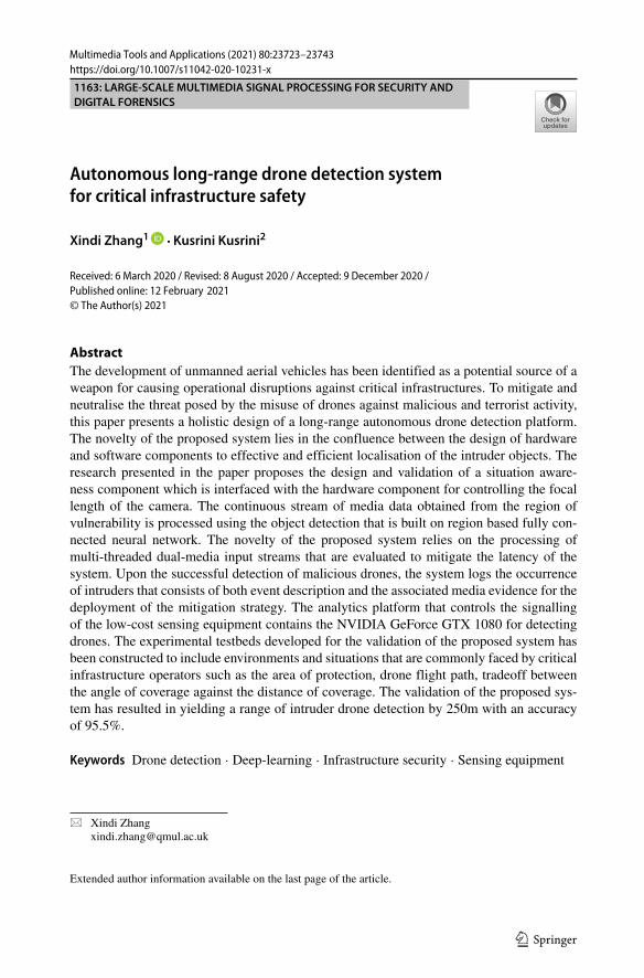
An example of the region to be protected against intruder drone is presented in Fig. 1.The security region is categorised into three namely (i) safe zone; (ii) alert zone and (iii)mitigate zone. The safe zone corresponds to the perimeter region, in which the presence ofany object does not present a danger to the operation of the critical zone. The region betweenthe safe and alert zone represents an increase in the threat level, and any object penetratingthe perimeter of the safe zone should be alerted of its presence to the infrastructure commandcenter. Subsequently, the violation of the alert zone is considered to pose an imminent threatto the infrastructure and thus will mitigation action should be executed to neutralise thethreat before the perimeter of the critical region is penetrated.
Fig. 1 The protection area of the camera system
23724 Multimedia Tools and Applications (2021) 80:23723–23743

Addressing the need to develop a system capable of being autonomously operated fordetecting the presence of malicious objects in the vicinity of critical infrastructure, theresearch in this paper presents a holistic system that consists of both software and hardwarecomponents. The software component consists of situation awareness module for identi-fying intruder objects appearing on the horizon and the object detection framework basedon the Region based Fully Connected Neural Network (RFCN) that can detect the drone.The hardware component is a low-cost sensor consisting of a pan-tilt-zoom (PTZ) platformcontrolled by servo motors and equipped with a camera capable of being programmaticallycontrolled for focal length changes. The signalling of the hardware equipment is triggeredby the software component based on a state machine that transitions between the scanningmode and the detection modes of operation. The state machines are designed to handlethe high-speed manoeuvrability of the drones and being piloted across a three-dimensionalcoordinate system.
The research contributions of the paper are:
• design and implementation of a situational awareness module that can monitor thehorizon for intruder appearance;
• to develop a hardware signalling module that temporally synchronises the situationawareness module and the object detection component;
• to identify the intruder object based on a multi-class deep-learning network usingRFCN and
• to estimate the distance of the intruder object and alert the command center forimplementing countermeasures to neutralise the threat of intruder objects.
The rest of the paper is structured as follows. In Section 2, a detailed review of var-ious drone detection systems reported in the literature is presented. The review includesthe analysis of long-range radar system for completeness. However, as the scope of theresearch presented in the paper relates to the application of computer vision technologies, adetailed analysis of the shortcomings from the techniques reported in the literature are fur-ther analysed. Subsequently, in Section 3, an overview of the proposed dual-camera systemfor autonomous long-range drone detection is presented. The section outlines the varioussoftware components that are designed to interface with the underlying hardware equip-ment. Section 4 presents in detail the performance evaluation of the proposed system carriedout in support of critical infrastructure operators. The discussion on the distance estimateapproaches is considered in Section 5. The conclusion and future work are presented inSection 6.
2 Literature review
The remotely piloted autonomous systems (RPAS) and the UAVs undertake unpredictablecomputer-controlled movements, that varies in speed and exploit the manoeuvring capa-bilities of the physical object. Their resemblance to other aerial objects such as birds,aeroplanes, result in challenges attributed to automatic detection, identification and mostimportantly accurate localisation in the 3D space. In order to solve this problem, severaltypes of sensors (RF, GPS, radio waves, radar, acoustic etc.) have been proposed in the liter-ature and subsequently been deployed for drone detection [28]. While the deployed sensorscan identify all the objects, it is important to recognise the specific malicious drone thatmight be approaching the Critical Infrastructures (CI) with the intention of creating harm.
23725Multimedia Tools and Applications (2021) 80:23723–23743
In this regard, the application of computer vision techniques has resulted in improved per-formance as reported in [10]. This is primarily attributed to the recent growth in the deeplearning technologies that have been shown to be very powerful in computer vision tasks.In the rest of the section, an outline of various approaches proposed in the literature issummarised.
Traditionally, the object detection task has been to classify regions of any predefinedobject in a training dataset. Early drone detection attempts used a similar approach todetect whether or not the image region consisted of drones. In this case, a computer visionapproach was used to select an appropriate representation of the object using handcraftedfeatures.
The most successful approaches using handcrafted features require bag of visual words(BoVW) was reported in [26] that includes representations of the objects with the help oflocal feature descriptors such as scale invariant feature transform (SIFT) [19], speeded-uprobust features (SURF) [1], and histogram of oriented gradients (HOG) [6]. After traininga discriminative machine learning (ML) model, e.g., support vector machines (SVM) [4],with such representations the images are scanned for the occurrence of learning objectswith sliding window technique. These reported methods have two crucial drawbacks. Thefirst one is that the features have to be crafted well for the problem domain to highlightand describe the important information in the image. The handcraft features are not robustenough for complex situations such as illumination variations, deformations, scale varia-tions and so on. The second one is the computational burden of the exhaustive search doneby the sliding window technique. The burden of sliding window waste too much time onbackground region which cannot run in real-time.
With the extremely large progress made by deep learning algorithms in the field of imageclassification tasks, similar methods have begun to be used to address target detection prob-lems. These techniques can be divided into two categories: methods based on a regionproposal and methods based on a single shot.. The first class of methods differs from tra-ditional methods in that it uses convolutional neural networks (CNNs) to learn the featuresof regions extracted through selective search or region proposal networks, as reported in [8,9, 23]. In the single shot approach, the goal is to directly compute the bounding boxes ofobjects in the image, rather than processing the regions of the image. One approach usesCNNs to extract multiscale features and combine them to predict the bounding box as pro-posed in [13, 18]. Another approach, called You Only Look Once (YOLO), reported in theliterature [22], divides the final feature map into a two-dimensional grid and uses each gridcell to predict a bounding box. The techniques mentioned originate from the overall goal ofobject detection and are not explicitly qualified to tackle the drone classification.. A largenumber of datasets that are trained on well-known objects that are frequently encounteredin real-life are used to develop a framework for detection.
While the previously reported approaches considered the use of feature extracted from asingle frame appearance of drones, the use of motion and spatio-temporal features has alsobeen studied. In particular, the approach that first creates spatio-temporal cubes using slidingwindow method at different scales, applies motion compensation to stabilise ST cubes, andfinally utilises boosted tree and CNN based regressors for bounding box detection [24]. Inaddition, Multi-frame representation of a drone is learnt by convolutional long short-termmemory (ConvLSTM) in [30]. The cross-correlation layer helps to generate search windowsand localize the drone.
Earlier approaches reported in the literature, have focused on detection accuracy withexisting datasets. However, those approaches have failed to specify the detection range of
23726 Multimedia Tools and Applications (2021) 80:23723–23743
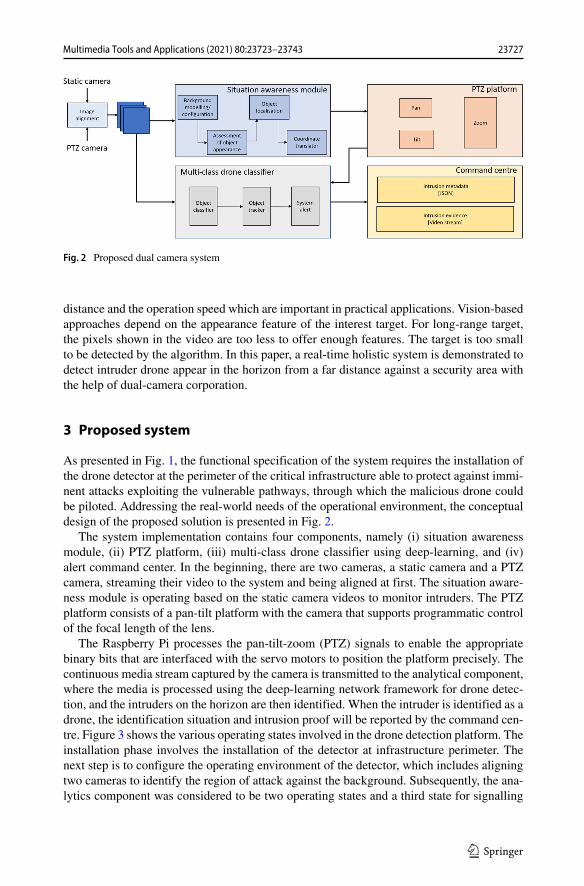
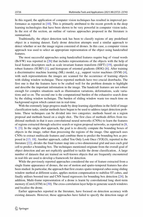
Fig. 2 Proposed dual camera system
distance and the operation speed which are important in practical applications. Vision-basedapproaches depend on the appearance feature of the interest target. For long-range target,the pixels shown in the video are too less to offer enough features. The target is too smallto be detected by the algorithm. In this paper, a real-time holistic system is demonstrated todetect intruder drone appear in the horizon from a far distance against a security area withthe help of dual-camera corporation.
3 Proposed system
As presented in Fig. 1, the functional specification of the system requires the installation ofthe drone detector at the perimeter of the critical infrastructure able to protect against immi-nent attacks exploiting the vulnerable pathways, through which the malicious drone couldbe piloted. Addressing the real-world needs of the operational environment, the conceptualdesign of the proposed solution is presented in Fig. 2.
The system implementation contains four components, namely (i) situation awarenessmodule, (ii) PTZ platform, (iii) multi-class drone classifier using deep-learning, and (iv)alert command center. In the beginning, there are two cameras, a static camera and a PTZcamera, streaming their video to the system and being aligned at first. The situation aware-ness module is operating based on the static camera videos to monitor intruders. The PTZplatform consists of a pan-tilt platform with the camera that supports programmatic controlof the focal length of the lens.
The Raspberry Pi processes the pan-tilt-zoom (PTZ) signals to enable the appropriatebinary bits that are interfaced with the servo motors to position the platform precisely. Thecontinuous media stream captured by the camera is transmitted to the analytical component,where the media is processed using the deep-learning network framework for drone detec-tion, and the intruders on the horizon are then identified. When the intruder is identified as adrone, the identification situation and intrusion proof will be reported by the command cen-tre. Figure 3 shows the various operating states involved in the drone detection platform. Theinstallation phase involves the installation of the detector at infrastructure perimeter. Thenext step is to configure the operating environment of the detector, which includes aligningtwo cameras to identify the region of attack against the background. Subsequently, the ana-lytics component was considered to be two operating states and a third state for signalling
23727Multimedia Tools and Applications (2021) 80:23723–23743
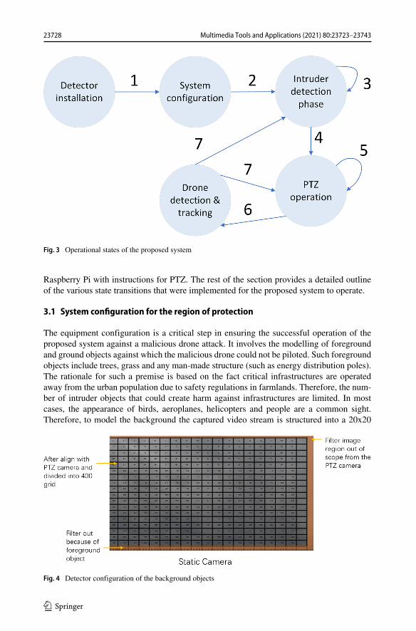
Fig. 3 Operational states of the proposed system
Raspberry Pi with instructions for PTZ. The rest of the section provides a detailed outlineof the various state transitions that were implemented for the proposed system to operate.
3.1 System configuration for the region of protection
The equipment configuration is a critical step in ensuring the successful operation of theproposed system against a malicious drone attack. It involves the modelling of foregroundand ground objects against which the malicious drone could not be piloted. Such foregroundobjects include trees, grass and any man-made structure (such as energy distribution poles).The rationale for such a premise is based on the fact critical infrastructures are operatedaway from the urban population due to safety regulations in farmlands. Therefore, the num-ber of intruder objects that could create harm against infrastructures are limited. In mostcases, the appearance of birds, aeroplanes, helicopters and people are a common sight.Therefore, to model the background the captured video stream is structured into a 20x20
Fig. 4 Detector configuration of the background objects
23728 Multimedia Tools and Applications (2021) 80:23723–23743
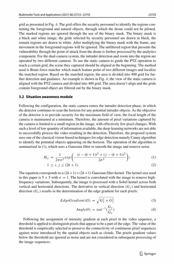
grid as presented in Fig. 4. The grid offers the security personnel to identify the regions con-taining the foreground and natural objects, through which the drone could not be piloted.The marked regions are ignored through the use of the binary mask. The binary mask isa black and white image, the grids selected by security personnel are drawn in black, theremain regions are drawn in white. After multiplying the binary mask with the frame, anymovement in the foreground regions will be ignored. The unfiltered region that presents thevulnerability through the point of attack from the drone is further processed by the analyticscomponent. For the dual-camera system, the intruder detection and zoom into the region areoperated by two different cameras. To use the static camera to guide the PTZ operation toreach a certain grid, the scene they captured should be aligned at the beginning. The methodused is Brute-force matcher which match feature point of two different images and localizethe matched region. Based on the matched region, the area is divided into 400 grid for fur-ther detection and guidance. An example is shown in Fig. 4, the view of the static camera isaligned with the PTZ camera and divided into 400 grid. The area doesn’t align and the gridscontain foreground object are filtered out by the binary mask.
3.2 Situation awareness module
Following the configuration, the static camera enters the intruder detection phase, in whichthe detector continues to scan the horizon for any potential intruder objects. As the objectiveof the detector is to provide security for the maximum field of view, the focal length of thecamera is maintained at a minimum. Therefore, the amount of pixel variations captured bythe camera is limited to a small region in the image, with effectively few pixel changes. Withsuch a level of low quantity of information available, the deep-learning networks are not ableto successfully process the video resulting in the detection. Therefore, the proposed systemuses one of the classical vision-based techniques for edge detection namely Canny algorithmto identify the potential objects appearing on the horizon. The operation of the algorithm issummarised in (1), which uses a Gaussian filter to smooth the image and remove noise.
Hij = 1
2πσ 2exp
(− (i − (k + 1))2 + (j − (k + 1))2
2σ 2
); (1)
1 ≤ i, j ≤ (2k + 1). (2)
The equation corresponds to a (2k+1)×(2k+1)Gaussian filter kernel. The kernel size usedin this paper is 5 × 5 with σ = 1. The kernel is convoluted with the image to remove high-frequency variations. Subsequently, the image is processed with a Sobel kernel across bothvertical and horizontal directions. The derivative in vertical direction (Gy) and horizontaldirection (Gx) results in the determination of the edge gradient for each pixels:
EdgeGradient (G) =√
G2x + G2
y (3)
Angle(θ) = tan−1(Gy
Gx
) (4)
Following the assignment of intensity gradient at each pixel in the video sequence, athreshold is applied to distinguish pixels that appear to be a part of the edge. The value of thethreshold is empirically selected to preserve the connectivity of continuous pixel sequencesagainst noise introduced by the spatial objects such as clouds. The pixels gradient valuesbelow the threshold are ignored as noise and are not considered in subsequent processing ofthe image sequences.
23729Multimedia Tools and Applications (2021) 80:23723–23743
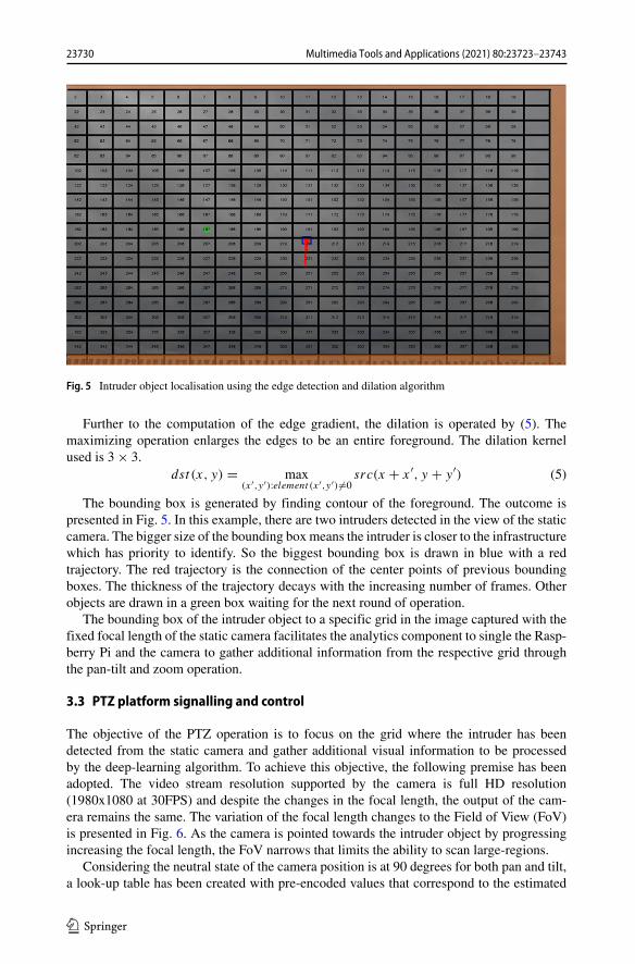
Fig. 5 Intruder object localisation using the edge detection and dilation algorithm
Further to the computation of the edge gradient, the dilation is operated by (5). Themaximizing operation enlarges the edges to be an entire foreground. The dilation kernelused is 3 × 3.
dst (x, y) = max(x′,y′):element (x′,y′)�=0
src(x + x′, y + y′) (5)
The bounding box is generated by finding contour of the foreground. The outcome ispresented in Fig. 5. In this example, there are two intruders detected in the view of the staticcamera. The bigger size of the bounding box means the intruder is closer to the infrastructurewhich has priority to identify. So the biggest bounding box is drawn in blue with a redtrajectory. The red trajectory is the connection of the center points of previous boundingboxes. The thickness of the trajectory decays with the increasing number of frames. Otherobjects are drawn in a green box waiting for the next round of operation.
The bounding box of the intruder object to a specific grid in the image captured with thefixed focal length of the static camera facilitates the analytics component to single the Rasp-berry Pi and the camera to gather additional information from the respective grid throughthe pan-tilt and zoom operation.
3.3 PTZ platform signalling and control
The objective of the PTZ operation is to focus on the grid where the intruder has beendetected from the static camera and gather additional visual information to be processedby the deep-learning algorithm. To achieve this objective, the following premise has beenadopted. The video stream resolution supported by the camera is full HD resolution(1980x1080 at 30FPS) and despite the changes in the focal length, the output of the cam-era remains the same. The variation of the focal length changes to the Field of View (FoV)is presented in Fig. 6. As the camera is pointed towards the intruder object by progressingincreasing the focal length, the FoV narrows that limits the ability to scan large-regions.
Considering the neutral state of the camera position is at 90 degrees for both pan and tilt,a look-up table has been created with pre-encoded values that correspond to the estimated
23730 Multimedia Tools and Applications (2021) 80:23723–23743
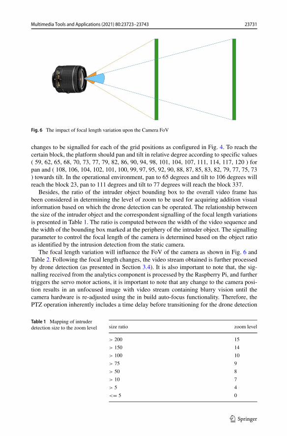
Fig. 6 The impact of focal length variation upon the Camera FoV
changes to be signalled for each of the grid positions as configured in Fig. 4. To reach thecertain block, the platform should pan and tilt in relative degree according to specific values( 59, 62, 65, 68, 70, 73, 77, 79, 82, 86, 90, 94, 98, 101, 104, 107, 111, 114, 117, 120 ) forpan and ( 108, 106, 104, 102, 101, 100, 99, 97, 95, 92, 90, 88, 87, 85, 83, 82, 79, 77, 75, 73) towards tilt. In the operational environment, pan to 65 degrees and tilt to 106 degrees willreach the block 23, pan to 111 degrees and tilt to 77 degrees will reach the block 337.
Besides, the ratio of the intruder object bounding box to the overall video frame hasbeen considered in determining the level of zoom to be used for acquiring addition visualinformation based on which the drone detection can be operated. The relationship betweenthe size of the intruder object and the correspondent signalling of the focal length variationsis presented in Table 1. The ratio is computed between the width of the video sequence andthe width of the bounding box marked at the periphery of the intruder object. The signallingparameter to control the focal length of the camera is determined based on the object ratioas identified by the intrusion detection from the static camera.
The focal length variation will influence the FoV of the camera as shown in Fig. 6 andTable 2. Following the focal length changes, the video stream obtained is further processedby drone detection (as presented in Section 3.4). It is also important to note that, the sig-nalling received from the analytics component is processed by the Raspberry Pi, and furthertriggers the servo motor actions, it is important to note that any change to the camera posi-tion results in an unfocused image with video stream containing blurry vision until thecamera hardware is re-adjusted using the in build auto-focus functionality. Therefore, thePTZ operation inherently includes a time delay before transitioning for the drone detection
Table 1 Mapping of intruderdetection size to the zoom level size ratio zoom level
> 200 15
> 150 14
> 100 10
> 75 9
> 50 8
> 10 7
> 5 4
<= 5 0
23731Multimedia Tools and Applications (2021) 80:23723–23743

Table 2 The mapping of FoVagainst camera focal length Signalling zoom level FoV Camera focal length (mm)
0 54.94 5.27
1 46.53 6.42
2 41.89 7.24
3 36.91 8.34
4 32.21 9.67
5 27.44 11.46
6 22.92 13.83
7 18.05 17.68
8 14.09 22.74
9 10.81 29.73
10 7.66 42.03
11 5.39 59.79
12 4.53 71.16
13 3.78 85.30
14 3.41 94.57
phase of operation. During the time of zoom in and re-adjust, the target may change its posi-tion which will be out of view for the PTZ camera. So the static camera keeps scanning thehorizon and guides the PTZ platform pointing to the latest grid position.
3.4 Multi-class drone classification using deep-learning
After PTZ platform zoom into the region, the view is large enough for operating objectdetection.
The training model used in the paper is based on an extension of the architectureproposed in [5]. Generally, the region-based object detection can be divided into threesub-networks that perform feature extraction, provide bounding boxes based on the region-proposal network, and perform final classification and bounding box regression. The featureextractor used by this paper is ResNet 101, as proposed in [12].
The RFCN places 100 layers in the shared subnetwork to transfer the time-consumingconvolutional neural network to the first two shared subnetworks and uses only one convolu-tion layer to calculate predictions. For dimensionality reduction purposes, the last 1000 classfully connected layer in ResNet101 is replaced by a 1 * 1 convolution layer with a depthof 1024. The K2(C + 1) -channel convolutional layer is then used to present the position-sensitive score map. RFCN has proposed the position-sensitive score map to improve theaccuracy. The region of interest (RoI) is divided into grids of K ∗K with a depth of (C + 1)(1 corresponds to the background) after getting region proposals. Every grid has its ownscores. Finally, the grid scores are combined to obtain the final output. The combined voteof the scores for each grid contributes to the determination in the respective RoI of the finalscores of the C + 1classes. C is the number of classes. Since object detection is trained toidentify drones, compared to other objects that may appear in the sky (e.g. birds, aeroplanes,etc.). In this paper C is set to 3, representing drones, birds, and airplanes, respectively.
23732 Multimedia Tools and Applications (2021) 80:23723–23743
RFCN’s loss function is as follows, which includes loss of classification and loss ofregression. As balance weight, the λ equals 1.
L(s, tx,y,w,h) = Lcls(sc∗) + λ[c∗ > 0]Lreg(t, t∗) (6)
In the equation above, c∗ is the RoI ground truth label (c∗ = 0 for background).lambda is the balanced weight that is set to 1. Classification uses the cross-entropy loss ofLcls(sc∗) = −log(sc∗). The bounding box coordinates are tx, y, w, h. Lreg is a boundingbox regression. To train the model, we used annotated images of drones, airplanes, and birds,each with 5000 images of each type. The model is exported in order to make predictionsafter 200,000 training steps.
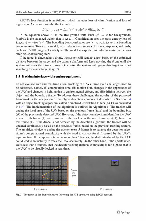
If the target is detected as a drone, the system will send an alarm based on the estimateddistance between the target and the camera platform and keep tracking the drone until thesystem mitigates the intruder drone. Otherwise, the system will ignore this target and startsearching for a new target (Fig. 7).
3.5 Tracking interface with sensing equipment
To achieve accurate and real-time visual tracking of UAVs, three main challenges need tobe addressed, namely (i) computation time, (ii) motion blur, changes in the appearance ofthe UAV and changes in lighting due to environmental effects, and (iii) drifting between theobject and the boundary frame. To address these challenges, the novelty of the proposedframework is the integration of the object detection component described in Section 3.4with an object tracking algorithm, called Kernelised Correlation Filters (KCF), as presentedin [14]. The implementation of the algorithm is outlined in Algorithm 1. The tracker willupdate the local area of the UAV based on the previous frame (Ii−1) and the bounding box(B) of the previously detected UAV. However, if the detection algorithm identifies the UAVin each fifth frame (k) will re-initialize the tracker in the next frame (k + 1), based onthis frame (k). If the drone is not detected by the detection algorithm, the tracker will beupdated continuously based on the previous frame, based on the previous tracking feature.The empirical choice to update the tracker every 5 frames is to balance the detection algo-rithm’s computational complexity with the need to correct for drift caused by the UAV’srapid motion. If the update interval is more than 5 frames, the drift introduced by the KCFcould lead to an inability to track the UAV accurately. On the other hand, if the update inter-val is less than 5 frames, then the detector’s computational complexity is too high to enablethe UAV to be visually locked in real time.
Fig. 7 The result of the drone detection following the PTZ operation using RFCN network
23733Multimedia Tools and Applications (2021) 80:23723–23743
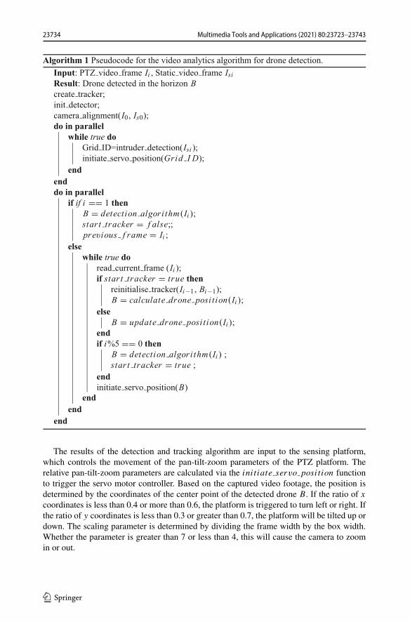
The results of the detection and tracking algorithm are input to the sensing platform,which controls the movement of the pan-tilt-zoom parameters of the PTZ platform. Therelative pan-tilt-zoom parameters are calculated via the initiate servo position functionto trigger the servo motor controller. Based on the captured video footage, the position isdetermined by the coordinates of the center point of the detected drone B. If the ratio of x
coordinates is less than 0.4 or more than 0.6, the platform is triggered to turn left or right. Ifthe ratio of y coordinates is less than 0.3 or greater than 0.7, the platform will be tilted up ordown. The scaling parameter is determined by dividing the frame width by the box width.Whether the parameter is greater than 7 or less than 4, this will cause the camera to zoomin or out.
23734 Multimedia Tools and Applications (2021) 80:23723–23743
3.6 Alert component
The final component of the proposed framework includes the alarm system to recordthe drone detection event into the centralised command centre deployed in the cloud forenabling the human operator to trigger a suitable mitigation action. The report metadatacontains two key data elements namely (i) event log and (ii) media log. The event log isa JavaScript Object Notation (JSON) structure consisting of detector deployment specifi-cation in terms of the orientation of the camera, Geolocation of the detector deployment,the associated reference to the critical infrastructure and the coordinate translation of thedetected drone from 2D visual plane to the 3D world coordinate. In addition, to the eventlog, it is vital to transmitting the associated media element to ensure the human opera-tor is provided with associated evidence prior to the deployment of the respective intruderdrone mitigation strategy. While there exist several techniques to transmit continuous mediastreams through the Internet Protocol (IP) network, the proposed framework adopts theevent-emitter design to optimise the data stream transmitted through the network. This isachieved using the event message protocol supported by Apache Kafka [21]. The detec-tor is configured to generate an event for each media timestamp in which the intruderdrone is detected. Upon such an event being received, the media bitstream is encoded as aJPEG image and the data is posted to the pre-determined message queue. The cloud-hostedApache Kafka is interfaced with a consumer, which is hosted upon the Flask server [11].The consumer end-point is accessed via the web browser to facilitate the visualisation of themedia evidence that is associated with the event log. The Uniform Resource Locator (URL)for accessing the media log is also included in the event log for visualising the media objectobtained from the Kafka message queues.
4 Experimental result
To evaluate the performance of the whole system, each component tests separately. Thealgorithm part tested on record videos with ground truth label to evaluate their performancevia Average Precision (AP) [7] and Central Distance Curve Metric [3, 29]. The system parttested by field trails in the real world to evaluate the capability of (i) maximum distance forintruder monitor distance by the static camera, (ii) the overall drone detection performanceof the dual-camera system and (iii) the performance of the alert component. Those testsare implemented in Olympic Park, London, with DJI Phantom 3 which offer ground truthtrajectory with time stamp for evaluating the system.
In the algorithmic part, the proposed security framework for targeting drone attacks isexperimentally evaluated using visual analysis techniques in two phases, namely (i) theaccuracy of the detection algorithm implemented using RFCN and (ii) the efficiency of theproposed approach in tracking the flight path of the drone. The experimental results arebased on a set of video footage in an urban environment taken within 450m from the attackpoint, using the DJI Phantom 3 Standard as a pilot. A total of 39 attack simulations werecreated, with the duration of each attack ranging from 6 to 117 seconds, resulting in a totalof 12.36 minutes of drone flight.
For the system part, the autonomous drone detection system is installed. The static cam-era and PTZ camera have the same focal length and imitate the situation of attaching fromthe horizon. The system is placed on the perimeter of the infrastructure and pointing to the
23735Multimedia Tools and Applications (2021) 80:23723–23743
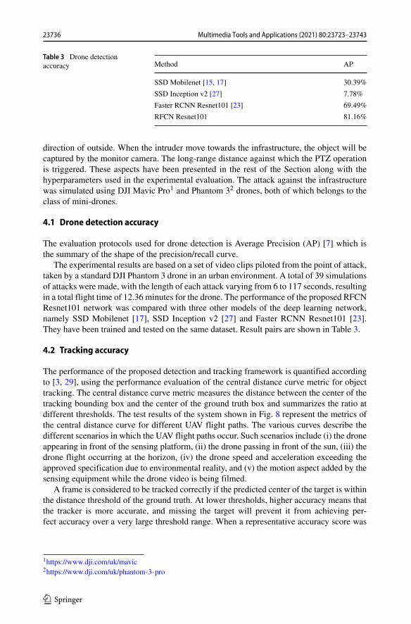
Table 3 Drone detectionaccuracy Method AP
SSD Mobilenet [15, 17] 30.39%
SSD Inception v2 [27] 7.78%
Faster RCNN Resnet101 [23] 69.49%
RFCN Resnet101 81.16%
direction of outside. When the intruder move towards the infrastructure, the object will becaptured by the monitor camera. The long-range distance against which the PTZ operationis triggered. These aspects have been presented in the rest of the Section along with thehyperparameters used in the experimental evaluation. The attack against the infrastructurewas simulated using DJI Mavic Pro1 and Phantom 32 drones, both of which belongs to theclass of mini-drones.
4.1 Drone detection accuracy
The evaluation protocols used for drone detection is Average Precision (AP) [7] which isthe summary of the shape of the precision/recall curve.
The experimental results are based on a set of video clips piloted from the point of attack,taken by a standard DJI Phantom 3 drone in an urban environment. A total of 39 simulationsof attacks were made, with the length of each attack varying from 6 to 117 seconds, resultingin a total flight time of 12.36 minutes for the drone. The performance of the proposed RFCNResnet101 network was compared with three other models of the deep learning network,namely SSD Mobilenet [17], SSD Inception v2 [27] and Faster RCNN Resnet101 [23].They have been trained and tested on the same dataset. Result pairs are shown in Table 3.
4.2 Tracking accuracy
The performance of the proposed detection and tracking framework is quantified accordingto [3, 29], using the performance evaluation of the central distance curve metric for objecttracking. The central distance curve metric measures the distance between the center of thetracking bounding box and the center of the ground truth box and summarizes the ratio atdifferent thresholds. The test results of the system shown in Fig. 8 represent the metrics ofthe central distance curve for different UAV flight paths. The various curves describe thedifferent scenarios in which the UAV flight paths occur. Such scenarios include (i) the droneappearing in front of the sensing platform, (ii) the drone passing in front of the sun, (iii) thedrone flight occurring at the horizon, (iv) the drone speed and acceleration exceeding theapproved specification due to environmental reality, and (v) the motion aspect added by thesensing equipment while the drone video is being filmed.
A frame is considered to be tracked correctly if the predicted center of the target is withinthe distance threshold of the ground truth. At lower thresholds, higher accuracy means thatthe tracker is more accurate, and missing the target will prevent it from achieving per-fect accuracy over a very large threshold range. When a representative accuracy score was
1https://www.dji.com/uk/mavic2https://www.dji.com/uk/phantom-3-pro
23736 Multimedia Tools and Applications (2021) 80:23723–23743
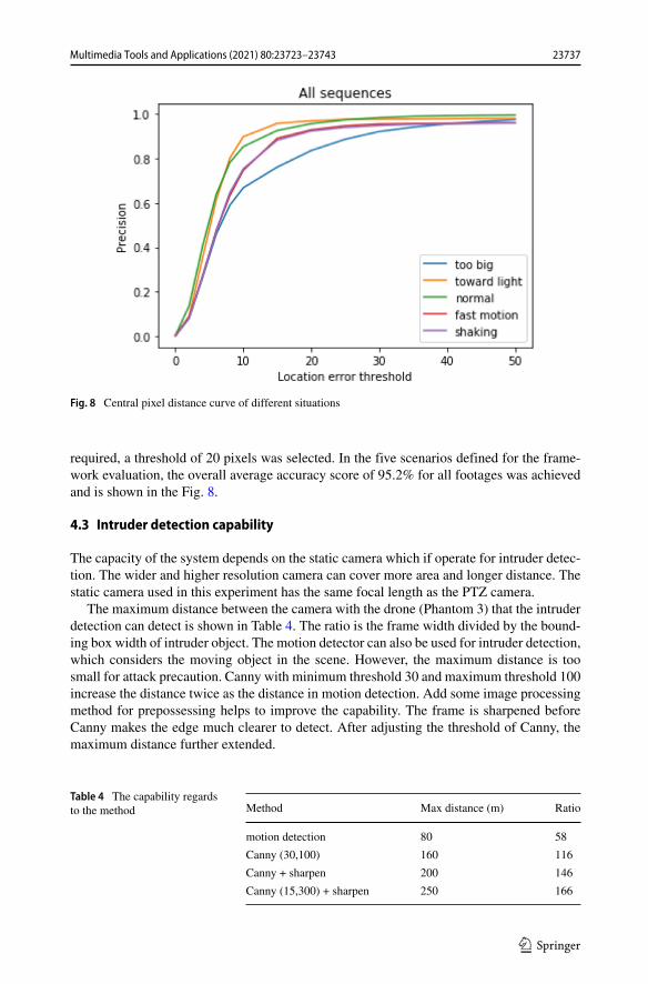
Fig. 8 Central pixel distance curve of different situations
required, a threshold of 20 pixels was selected. In the five scenarios defined for the frame-work evaluation, the overall average accuracy score of 95.2% for all footages was achievedand is shown in the Fig. 8.
4.3 Intruder detection capability
The capacity of the system depends on the static camera which if operate for intruder detec-tion. The wider and higher resolution camera can cover more area and longer distance. Thestatic camera used in this experiment has the same focal length as the PTZ camera.
The maximum distance between the camera with the drone (Phantom 3) that the intruderdetection can detect is shown in Table 4. The ratio is the frame width divided by the bound-ing box width of intruder object. The motion detector can also be used for intruder detection,which considers the moving object in the scene. However, the maximum distance is toosmall for attack precaution. Canny with minimum threshold 30 and maximum threshold 100increase the distance twice as the distance in motion detection. Add some image processingmethod for prepossessing helps to improve the capability. The frame is sharpened beforeCanny makes the edge much clearer to detect. After adjusting the threshold of Canny, themaximum distance further extended.
Table 4 The capability regardsto the method Method Max distance (m) Ratio
motion detection 80 58
Canny (30,100) 160 116
Canny + sharpen 200 146
Canny (15,300) + sharpen 250 166
23737Multimedia Tools and Applications (2021) 80:23723–23743
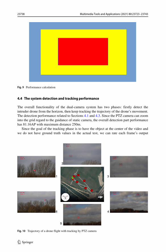
Fig. 9 Performance calculation
4.4 The system detection and tracking performance
The overall functionality of the dual-camera system has two phases: firstly detect theintruder drone from the horizon, then keep tracking the trajectory of the drone’s movement.The detection performance related to Sections 4.1 and 4.3. Since the PTZ camera can zoominto the grid regard to the guidance of static camera, the overall detection part performancehas 81.16AP with maximum distance 250m.
Since the goal of the tracking phase is to have the object at the center of the video andwe do not have ground truth values in the actual test, we can rate each frame’s output
Fig. 10 Trajectory of a drone flight with tracking by PTZ camera
23738 Multimedia Tools and Applications (2021) 80:23723–23743
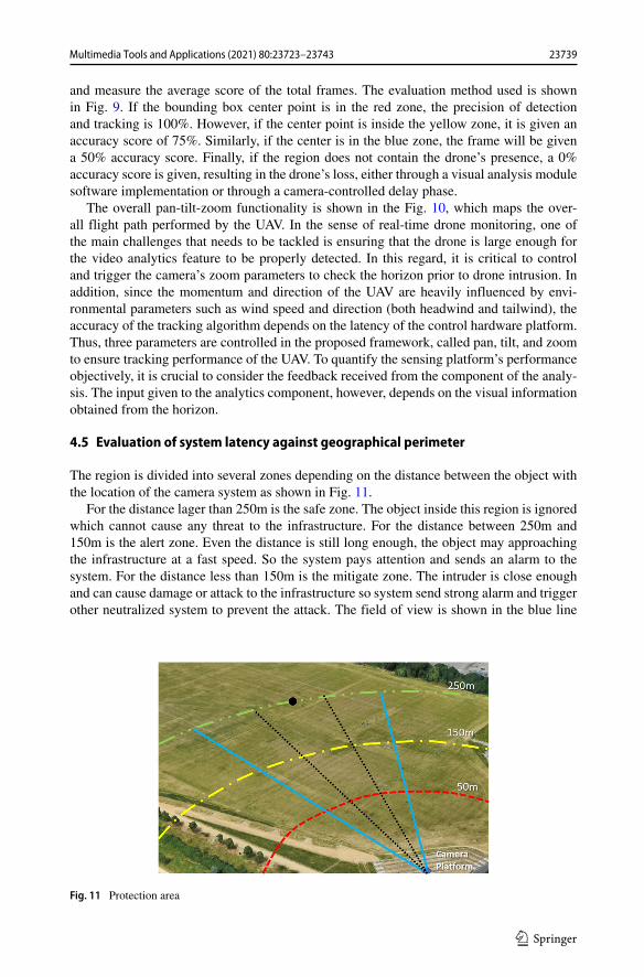
and measure the average score of the total frames. The evaluation method used is shownin Fig. 9. If the bounding box center point is in the red zone, the precision of detectionand tracking is 100%. However, if the center point is inside the yellow zone, it is given anaccuracy score of 75%. Similarly, if the center is in the blue zone, the frame will be givena 50% accuracy score. Finally, if the region does not contain the drone’s presence, a 0%accuracy score is given, resulting in the drone’s loss, either through a visual analysis modulesoftware implementation or through a camera-controlled delay phase.
The overall pan-tilt-zoom functionality is shown in the Fig. 10, which maps the over-all flight path performed by the UAV. In the sense of real-time drone monitoring, one ofthe main challenges that needs to be tackled is ensuring that the drone is large enough forthe video analytics feature to be properly detected. In this regard, it is critical to controland trigger the camera’s zoom parameters to check the horizon prior to drone intrusion. Inaddition, since the momentum and direction of the UAV are heavily influenced by envi-ronmental parameters such as wind speed and direction (both headwind and tailwind), theaccuracy of the tracking algorithm depends on the latency of the control hardware platform.Thus, three parameters are controlled in the proposed framework, called pan, tilt, and zoomto ensure tracking performance of the UAV. To quantify the sensing platform’s performanceobjectively, it is crucial to consider the feedback received from the component of the analy-sis. The input given to the analytics component, however, depends on the visual informationobtained from the horizon.
4.5 Evaluation of system latency against geographical perimeter
The region is divided into several zones depending on the distance between the object withthe location of the camera system as shown in Fig. 11.
For the distance lager than 250m is the safe zone. The object inside this region is ignoredwhich cannot cause any threat to the infrastructure. For the distance between 250m and150m is the alert zone. Even the distance is still long enough, the object may approachingthe infrastructure at a fast speed. So the system pays attention and sends an alarm to thesystem. For the distance less than 150m is the mitigate zone. The intruder is close enoughand can cause damage or attack to the infrastructure so system send strong alarm and triggerother neutralized system to prevent the attack. The field of view is shown in the blue line
Fig. 11 Protection area
23739Multimedia Tools and Applications (2021) 80:23723–23743
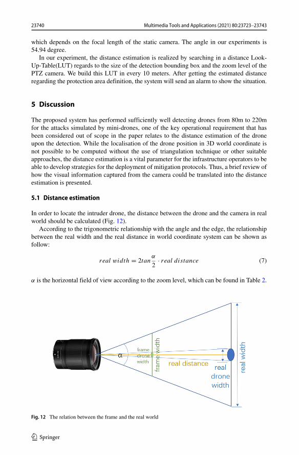
which depends on the focal length of the static camera. The angle in our experiments is54.94 degree.
In our experiment, the distance estimation is realized by searching in a distance Look-Up-Table(LUT) regards to the size of the detection bounding box and the zoom level of thePTZ camera. We build this LUT in every 10 meters. After getting the estimated distanceregarding the protection area definition, the system will send an alarm to show the situation.
5 Discussion
The proposed system has performed sufficiently well detecting drones from 80m to 220mfor the attacks simulated by mini-drones, one of the key operational requirement that hasbeen considered out of scope in the paper relates to the distance estimation of the droneupon the detection. While the localisation of the drone position in 3D world coordinate isnot possible to be computed without the use of triangulation technique or other suitableapproaches, the distance estimation is a vital parameter for the infrastructure operators to beable to develop strategies for the deployment of mitigation protocols. Thus, a brief review ofhow the visual information captured from the camera could be translated into the distanceestimation is presented.
5.1 Distance estimation
In order to locate the intruder drone, the distance between the drone and the camera in realworld should be calculated (Fig. 12).
According to the trigonometric relationship with the angle and the edge, the relationshipbetween the real width and the real distance in world coordinate system can be shown asfollow:
real width = 2tanα
2· real distance (7)
α is the horizontal field of view according to the zoom level, which can be found in Table 2.
Fig. 12 The relation between the frame and the real world
23740 Multimedia Tools and Applications (2021) 80:23723–23743
The ratio of real width of field and the width of the real drone is equal to the ratio of theframe width and the drone width in the frame. So the equation is:
real width
real drone width= f rame width
f rame drone width(8)
And the equation can be transform into:
real width = f rame width
f rame drone width· real drone width (9)
Then put the equation into (7) will get:
real distance =f rame width
drone width in f rame· real drone width
2tanαzoom
2
(10)
The frame width equals the resolution of the HD video captured by the camera. The widthof the drone detected within the frame is to be obtained by the area of the detected boundingbox. The appearance of the drone in the real world is dependent upon the physical dimen-sions of different drones as specified by the manufacturers. Following the level of focallength parameter of the camera, the distance between the camera and the detected drone canbe estimated by (10). The validation of the above mathematical analysis is to be carried outagainst different sizes of the drone.
6 Conclusion
In this paper, an operational prototype of a long-range drone detection system is presentedequipped to protect critical infrastructures against drone attacks. The system presents aseamless operation between the deep-learning algorithm signalling low-cost hardware. Thenovelty of the paper lies in the ability of the system to detect intruder objects flying at theperimeter of infrastructure with minimal visual information and subsequently attain morevisual data to detect malicious drones. The mechanism helps to enlarge the distance ofprotection. The design of the dual-camera system helps to minimize the latency betweenthe intruder object monitor phase and deep-learning based drone detection phase so that iscapable to run in real-time. The combination between RFCN and KCF help to improve thedrone detection accuracy and as outlined in the experimental results an overall 95.2% aver-age precision score against drone attacks was achieved by the platform. The future workwill continue to investigate approaches to compute the distance which can be used to deploymitigating strategies for infrastructure security.
Open Access This article is licensed under a Creative Commons Attribution 4.0 International License, whichpermits use, sharing, adaptation, distribution and reproduction in any medium or format, as long as you giveappropriate credit to the original author(s) and the source, provide a link to the Creative Commons licence,and indicate if changes were made. The images or other third party material in this article are included in thearticle’s Creative Commons licence, unless indicated otherwise in a credit line to the material. If material isnot included in the article’s Creative Commons licence and your intended use is not permitted by statutoryregulation or exceeds the permitted use, you will need to obtain permission directly from the copyright holder.To view a copy of this licence, visit http://creativecommonshorg/licenses/by/4.0/.
23741Multimedia Tools and Applications (2021) 80:23723–23743

References
1. Bay H, et al. (2008) Speeded-up robust features (SURF). In: Computer vision and image understanding,vol 110.3, pp 346–359
2. Brust MR, et al. (2018) Defending against intrusion of malicious UAVs with networked UAV defenseswarms. In: CoRR arXiv:1808.06900
3. Cehovin L, Leonardis A, Kristan M (2015) Visual object tracking performance measures revisited. In:CoRR arXiv:1502.05803
4. Cortes C, Vapnik V (1995) Support-vector networks. In: Machine learning, vol 20.3, pp 273–2975. Dai J, et al. (2016) R-FCN: object detection via region-based fully convolutional networks. In: CoRR
arXiv:1605.064096. Dalal N, Triggs B (2005) Histograms of oriented gradients for human detection. In: 2005 IEEE computer
society conference on computer vision and pattern recognition (CVPR’05), vol 1. IEEE, pp 886–8937. Everingham M, et al. (2010) The pascal visual object classes (VOC) challenge. In: International journal
of computer vision, vol 88.2, pp 303–338. ISSN: 1573-1405. https://doi.org/10.1007/s11263-009-0275-48. Girshick R, et al. (2014) Rich feature hierarchies for accurate object detection and semantic seg-
mentation. In: Proceedings of the IEEE conference on computer vision and pattern recognition,pp 580–587
9. Girshick R (2015) Fast r-cnn. In: Proceedings of the IEEE international conference on computer vision,pp 1440–1448
10. Gokce F, et al. (2015) Vision-based detection and distance estimation of micro unmanned aerial vehicles.In: Sensors, vol 15.9, pp 23805–23846
11. Grinberg M (2014) Flask web development: developing web applications with python. 1st. O’ReillyMedia, Inc. ISBN: 1449372627, 9781449372620
12. He K, et al. (2015) Deep residual learning for image recognition. In: CoRR arXiv:1512.0338513. He K, et al. (2015) Spatial pyramid pooling in deep convolutional networks for visual recognition. In:
IEEE transactions on pattern analysis and machine intelligence, vol 37.9, pp 1904–191614. Henriques JF, et al. (2014) High-speed tracking with kernelized correlation filters. In: CoRR
arXiv:1404.758415. Howard AG, et al. (2017) MobileNets: efficient convolutional neural networks for mobile vision
applications. In: CoRR arXiv:1704.0486116. Li Y, et al. (2019) Scale-aware trident networks for object detection. In: CoRR arXiv:1901.0189217. Liu W, et al. (2015) SSD: single shot multibox detector. In: CoRR arXiv:1512.0232518. Liu W, et al. (2016) Ssd: single shot multibox detector. In: European conference on computer vision.
Springer, pp 21–3719. Lowe DG (1999) Object recognition from local scale-invariant features. In: Proceedings of the seventh
IEEE international conference on computer vision, vol 2. IEEE, pp 1150–115720. Lu Y, Javidi T, Lazebnik S (2015) Adaptive object detection using adjacency and zoom prediction. In:
CoRR arXiv:1512.0771121. Narkhede N, Shapira G, Palino T (2017) Kafka: the definitive guide real-time data and stream processing
at scale. 1st. O’Reilly Media, Inc. ISBN: 1491936169, 978149193616022. Redmon J, et al. (2016) You only look once: unified, real-time object detection. In: Proceedings of the
IEEE conference on computer vision and pattern recognition, pp 779–78823. Ren S, et al. (2015) Faster R-CNN: towards real-time object detection with region proposal networks.
In: CoRR arXiv:1506.0149724. Rozantsev A, Lepetit V, Fua P (2017) Detecting flying objects using a single moving camera. In: IEEE
transactions on pattern analysis and machine intelligence, vol 39.5, pp 879–892. ISSN: 1939-3539.https://doi.org/10.1109/TPAMI.2016.2564408
25. Singh B, Najibi M, Davis LS (2018) SNIPER: efficient multi-scale training. In: CoRR arXiv:1805.0930026. Sivic J, Zisserman A (2003) Video google: a text retrieval approach to object matching in videos. In:
Null. IEEE, p 147027. Szegedy C, et al. (2015) Rethinking the inception architecture for computer vision. In: CoRR
arXiv:1512.0056728. Taha B, Shoufan A (2019) Machine learning-based drone detection and classification: state-of-the-
art in research. In: IEEE access, vol 7, pp 138669–138682. ISSN: 2169-3536. https://doi.org/10.1109/ACCESS.2019.2942944
29. Wu Y, Lim J, Yang M (2013) Online object tracking: a benchmark. In: 2013 IEEE conference oncomputer vision and pattern recognition, pp 2411–2418. https://doi.org/10.1109/CVPR.2013.312
23742 Multimedia Tools and Applications (2021) 80:23723–23743
30. Yoshihashi R, et al. (2017) Learning multi-frame visual representation for joint detection and trackingof small objects. In: CoRR arXiv:1709.04666
31. Zhang X, Chandramouli K (2019) Critical infrastructure security against drone attacks using visual ana-lytics. In: Tzovaras D, et al. (eds) Computer vision systems. Springer International Publishing, Cham,pp 713–722. ISBN: 978-3-030-34995-0
Publisher’s note Springer Nature remains neutral with regard to jurisdictional claims in published mapsand institutional affiliations.
Affiliations
Xindi Zhang1 ·Kusrini Kusrini2
Kusrini [email protected]
1 Multimedia and Vision Group, School of Electronic Engineering and Computer Science,Queen Mary University of London, Mile End Road, London E1 4NS, UK
2 Universitas AMIKOM Yogyakarta, Jl. Ringroad Utara Condong Catur Depok Sleman,Yogyakarta, Indonesia
23743Multimedia Tools and Applications (2021) 80:23723–23743