Embed Size (px)
Citation preview

AVAILABILITY OF REAL TIME GIS AND IC TAG FORREALIZATION OF UNIVERSAL MAP
Sota Shimano*, Mitoshi Moriya, Masaaki Shikada**
Kanazawa Institute of Technology (KIT) 7-1 Ohgigaoka, Nonoichi, Ishikawa 921-8501, JAPAN* * ( [email protected]:Until end of March 2008)
** ([email protected])
KEY WORDS: REAL TIME GIS, Universal Map, D-GPS, VRS-GPS, Spatial Information Society, IC Tag
ABSTRACT:
Government and local government have to hurry up to build accessible facilities for elderly people and people with disabilities.Because our country is experiencing an aging society, for example, pedestrian space should be safe and give a relief. However, it is difficult for everyone to easily know the route from the present place to a destination safely and at ease. One of the methods to solve those problems is to obtain absolute positions accurately. Therefore, we suggested here to make Universal Map (UM) with a largescale by using REAL TIME GIS with mobile mapping. And, it is a map including recent information for enabling people to understand the condition of absolute positions. The purpose of the research was to confirm whether absolute positions can be obtained accurately in mobile mapping. For the purpose, an experiment was performed on our campus at Kanazawa district in Japanby using a D-GPS and a VRS-GPS. The experiment was performed by moving in the campus by a wheelchair to which a GPS antenna has been attached. As a result, it became clear that one could not receive accurate data in any experiment fields. To solvethese problems, we adopted IC tags using a new ubiquitous technology to help people with disabilities. With the powerful advantageof IC tags, one can receive data without any contact anytime, anywhere. Therefore, it is recommended that the UM be made by theREAL TIME GIS and IC tags.
1. INTRODUCTION
The birth rate is decreasing, the number of elderly people isincreasing, and people with disabilities are unable to live a happy life in society, which are big problems in Japan. It is suggested that the general society needs safety, relief and comfort in the near future. Recent internationalization of Japan increased tourists from foreign countries. However, many tourists including domestic persons feel some inconveniences in understanding where they stay now and how to select the best route to their destination from the present place.
One of the methods to solve those problems is to obtain the absolute position accurately by using geoinformatics. In this study, the concepts of "Real Time GIS” were used, where it comprise Geographic Information System (GIS), Global Positioning System (GPS), and Remote Sensing (RS). If Real-Time Kinematic - GPS (RTK-GPS) is used, a digital map (DM) will change to realistic UM. It means that anyone can feel a comfortable life anytime, anywhere, for example, safe pedestrian space and a relieved life ubiquitously.
REAL TIME GIS is the system for real-time mapping at the field site using RTK-GPS, Virtual Reference Station - GPS (VRS-GPS), and GIS. It is possible to update DM data in real time by using a cellular phone and RTK-GPS which hassimultaneity. Moreover, UM including the proposed concept will be used by all users including the physically challenged and aged people. Concept of "Real Time GIS” has been studied for about a decade by us (Figure 1).
Pedestrian GIS Server S
The basis of UM is a surveying and it consists of geoinformatics which is the latest survey technology. Anyone can use UM regardless of the physically challenged, healthy person, age, man and woman. Figure 2 shows the essential and minimum requirements of UM and the concept of UM.
Figure 1. Concept of “REAL TIME GIS”
RTK-GPSPositioning Refreshing map
Figure 2. Concept of “Universal Map” UM means the newest map which can display the latest road
condition and other information on a mobile PC. This map includes the recent information by which all users can understand the condition of absolute position anytime,
899

anywhere. Additionally, measures to utilize spatial information become extremely important and the society might need UM with a lot of advantages in the future.
20m 0
2. PURPOSE OF STUDY
Japan has been adopting a new standard for map geometry since April 1, 2002. Ellipsoid of a new geodetic system in Japan is almost equal to WGS-84 of GPS but most of the DM of local government is still Tokyo Datum of an old geodetic system. To correspond with two kinds of data which have different geodetic systems, it is necessary to transform coordinates 1).
On the other hand, much local government has been utilizing a large scale (1/500 or 1/1000) DM with GIS. Government promulgated the law of National Spatial Data Infrastructure (NSDI) to construct the advanced spatial information society May 2007 2). GIS will be able to efficiently help many workers who are managers and city planners in government and researchers. As an example, it is possible to improve the service to a citizen including elderly people and the physically challenged by sharing those data in local government. However, the maintenance and renewal of UM database need much labor and time and updating a map has not been established yet and, there are only a few successful examples. This is a specific problem of a large scale map to achieve the spatial information society now.
In the master's thesis of Ms. Naoko Matsuda who graduated from Kanazawa Institute of Technology (KIT), these problems were solved by using Real Time GIS and the achieved result is listed below 3).
(1) Position data of latitude and longitude had a high accuracy within 3 cm.
(2) It is difficult to acquire high-accuracy data because geoids may influence the accuracy of height.
(3) Tracks were not displayed well though she tried to display tracks which moved by using a RTK-GPS in GIS because canopies interrupt wavelengths from satellites.
As a result, at this stage, it is very difficult to solve problems by using a GPS only. Interruption of signals in course includes very important problems. If anyone is able to receive the positioning data ubiquitously, people will obtain safe, relieved, and comfortable service.
The purpose of this study is to establish a method for updating a large scale map for local government, and to propose UM by using RS, GPS, and GIS. These are new concepts of collaboration of geoinformatics technologies. Additionally, the important purpose of study is how to acquire the accurate positioning information without interrupting satellites information.
3. EXPERIMENT BY GPS POSITIONING
An experiment was performed inside the KIT campus at Kanazawa district in central Japan by using a D-GPS and a VRS-GPS. The purpose of the experiment is to acquire positional data accurately and to understand the feature of places where accuracy is poor. Accuracy of positioning D-GPS and VRS-GPS was verified.
Figure 3 shows the experiment field and the route. Background of Figure 3 is Base Map of the Nonoichi town on a scale of 1/2500 (Accept: Nonoichi town office). ArcGIS 9.1 which is one of the general software of GIS was used to display the map and analyze the data.
Figure 3. Experiment field and route
3.1
3.2
RTK-GPS Positioning
In this paper, RTK-GPS means that a reference station and a rover station were required for real-time GPS positioning. The reference station was made just on a control point. This control point is a leveling point which has the absolute position because the accurate positioning data by using static positioning were needed. The specified low power radio broadcast is used on the communication from the reference station to the rover station for the RTK-GPS receiver.
The experiment was conducted by moving around by a wheelchair which is equipped with RTK-GPS at uniform speed inside KIT campus. Additionally, I have carried out the experiment by holding the RTK-GPS equipment with hands. In that condition, I could not obtain positioning data because a GPS antenna was swung on moving. This is the reason why a GPS was attached to the wheelchair or a hand truck for reducing an error. However, many errors happened in the most of fields by using a RTK-GPS. One of the reasons for causing errors was the buildings between the positioning points because the communication area of radio broadcasts was narrow in such a situation 6).
VRS-GPS Positioning
A second experiment was performed by using VRS-GPS that is a kind of RTK-GPS positioning. In VRS-GPS, the reference station needs not be set. A virtual reference station was made virtually around the positioning point. The distance of a virtual point to an actual point is about 3m to 5m. A rover station received correction information from a mobile phone by using a wireless system. This system consists of GPS-based control stations. GSI made it about 1200 stations in Japan. In the wireless system, only one person is capable of positioning with a light baggage. The method of measurement is similar to that of RTK-GPS. Therefore, VRS-GPS has more advantages. More
The International Archives of the Photogrammetry, Remote Sensing and Spatial Information Sciences. Vol. XXXVII. Part B4. Beijing 2008
900

Figure 4. Positioning of D-GPS and VRS-GPS
specifically, it allows only one person to make real-time positioning, has a simple configuration, and has high accuracy.
3.3
4.1
D-GPS Positioning
D-GPS positioning is a method that sends the corrected value of a pseudo distance from each satellite, and calculates precision again in the rover station. Additionally, a rover station received correction data from a mobile phone by using GPS-based control station. Position accuracy is from 0.5m to 2.0m. This system is similar to the technique of VRS-GPS and it only needs a rover station. Moreover, the positioning cost is cheaper than that of VRS-GPS because of its simple system. The experiment performed by using a wheelchair with D-GPS and VRS-GPS simultaneously. The reason is to make the experimental environment almost the same and to acquire position data. Figure 4 shows the positioning of D-GPS and VRS-GPS by a wheelchair.
4. VERIFICATION OF OVERLAPPING
Positioning data of D-GPS and VRS-GPS were displayed on the DM (Base Map of the Nonoichi town on a scale of 1/2500) by using GIS software (Figure 5). Background of Figure 5 is an aerial photograph.
Result
As a result of experiments, GPS was able to receive high-accuracy data at almost all places. However, the data were not accurate at any places though the measured place had wide open sky. It seemed that other reasons affect a receiver. Data were intercepted at three spots, and a lot of measurement errors occurred there.
In the next stage, I confirmed how long a signal is received around a canopy by a D-GPS and a VRS-GPS. Figure 6 shows one of enlarged canopy areas in Figure 5.
Table 1 shows the length of interruption of raw data that were displayed on GIS. Table 2 shows the length of interruption of analytical data that include positional accuracy
D-GPS�VRS �
5th& 7th
1st
1st
20m0
&3rd
Figure 5. Overlapping of experiment data
D-GPS�VRS�
(a)Front stoop of 1st building
(b) Between 1st and 3rd building
(c) Between 5th and 7th building
Figure 6. Verification around each canopy
The International Archives of the Photogrammetry, Remote Sensing and Spatial Information Sciences. Vol. XXXVII. Part B4. Beijing 2008
901

Length of interrupted tracks Building No. D-GPS(m) VRS-GPS(m) 1st 4.624 7.908
1st and 3rd 5.119 7.3965th and 7th 2.374 5.419
Table 1� Length of i tion in raw
Length of interrupted tracks
nterrup data
Building No. D-GPS(m) VRS-GPS(m) 1st 15.313 12.574
1st and 3rd null 12.1305th and 7th 12.952 5.419Table 2� Length of int in analytica
.2 Consideration
portant condition of GPS positioning is to receive 4 sa
nals of the D-GPS were shorter than those of th
btain an absolute po
5. SOLUTION OF PROBLEMS BY USING IC TAG
edestrian space will become safer and securer if people are ab
� a without contact. small size.
its paper type. l be
ab
erruption l data
4
Imtellites or more at open sky. As a result, I acquired the
absolute position accurately at open sky. However GPS receiver was not able to receive signals from GPS satellites at an area surrounded by canopies and buildings. Additionally, one could not obtain continuous GPS signals at districts overgrown with trees. In such a place, correction data received by a mobile phone might not give acceptable data. An area surrounded by canopies and buildings causes that cycle slip and multipath to badly influence the DOP and GPS signals. If GPS positioning is conducted near buildings, it is necessary to consider satellites situation and multi-path. Because those areas had poor signal conditions, remarkable differences were seen between D-GPS and VRS-GPS.
Interrupted sige VRS-GPS as shown in Table 1, but VRS-GPS showed
higher accuracy than that of D-GPS as shown in Table 2. As for the reasons for difference, VRS-GPS have the problem of initialization and D-GPS of simple system don’t have one 1).Therefore, it appears D-GPS had high continuousness and VRS-GPS had reliability of positioning accuracy.
In the next chapter, I will show how to osition and other information at a place where the GPS signal
does not reach.
AND GEOINFORMATICS
Ple to receive absolute positions and other information by
future spatial information technology. In this technology, I will adopt an Integrated Circuit tag (IC tag) to assist people including the physically challenged. Major advantages of IC tag are listed below 4).
The IC tag can �Receive the dat
��Memorize a lot of data and be very��Easily add information and update data. ��Have high durability is better than that of
If IC tag's powerful advantage is used fully, everyone wille to receive the positioning data anytime and anywhere. For
example, GPS positioning is used at open sky, and IC tags are used at closed sky, which are good ideas because one can continuously receive the signal from satellites and IC tags. In this system, the positioning information will be imagined ubiquitously (Figure 7).
Figure 7. Utilization of IC tag
6. EXPERIMENT BY IC TAGS FOR SPATIAL INFORMATION SOCIETY
Preliminary experiments were performed by using reader of middle-range and several IC tags which frequency band is 13.56 MHz. The purpose of experiments is to obtain basic data of IC tags for realization of seamless positioning. The experiment was conducted by using hand truck which attached the IC tag reader. IC tags were lineally set out and Unique Identifier (UID) of them was read by moving on the straight line (Figure 8). Additionally, the ratio of UID reading was indicated that how many pieces are able to read among 1000 tags.
As a result of experiments, the maximum reading distance was about 40 cm though the specification of it is 50 cm. Therefore, the height of IC tag's reader fixed from 15cm to 40 cm in consideration for the condition of hand truck. After the experiments, we found that the error factor of IC tags and good measurement environment of reading rate.
Figure 8. Verification experiment of IC tag
Several experiments were conducted to confirm influence of reading rate. Each condition for research and experimental overview are listed below. (1) Material of the ground: It can easily influence that the
metal, the water and other materials for to IC tag. First experiment was performed at any places such as cement concrete, asphalt concrete, earthenware tile and fireclay brick.
(2) Interval of IC tags: As a result of preliminary experiment,
Open Sky GPS
GPS Satellite IC tag
Closed skyIC tag
The International Archives of the Photogrammetry, Remote Sensing and Spatial Information Sciences. Vol. XXXVII. Part B4. Beijing 2008
902
IC tag could not be read when the interval was too narrow. Second experiment has the space in the interval of IC tags.
(3) Material and size of IC tags: Material and antenna size of IC tag is variety. Third experiment was performed byusing ceramics type of IC tags which has high durability, general card type and paper type
6.1 Result
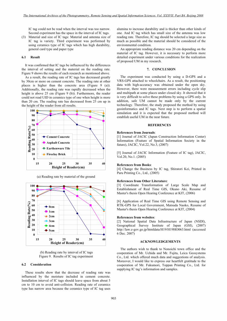
It was confirmed that IC tags be influenced by the differences the interval of setting and the material on the reading rate. Figure 9 shows the results of each research as mentioned above.
As a result, the reading rate of IC tags has decreased greatly by 30cm or more on cement concrete. The reading rate at other places is higher than the concrete area (Figure 9 (a)). Additionally, the reading rate was rapidly decreased when the height is above 25 cm (Figure 9 (b)). Furthermore, the reader could not read UID in ceramics type of one when height is more than 20 cm. The reading rate has decreased from 25 cm up in the height of the reader from all results.
0102030405060708090
100
15 20 25 30 35 40Height of Reader(cm)
Rea
ding
Rat
e(%
)
Cement Concrete
Asphalt Concrete
Earthenware Tile
Fireclay Brick
(a) Reading rate by material of the ground
0102030405060708090
100
15 20 25 30 35 40Height of Reader(cm)
Rea
ding
Rat
e(%
)
0cm1cm2cm3cm4cm5cm
(b) Reading rate by interval of IC tags Figure 9. Results of IC tag experiment
6.2 Consideration
These results show that the decrease of reading rate was influenced by the moisture included in cement concrete. Installation interval of IC tags should leave space from about 5 cm to 10 cm to avoid anti-collision. Reading rate of ceramics type has narrow area because the ceramics type of IC tag uses
alumina to increase durability and is thicker than other kinds of one. And IC tag which has small size of the antenna was low reading rate. Therefore, IC tag should be selected a large size as much as possible and the material should be considered of the environmental condition.
An appropriate reading distance was 20 cm depending on the material of IC tag. However, it is necessary to perform moredetailed experiment under various conditions for the realization of proposed UM in my research.
7. CONCLUSION
The experiment was conducted by using a D-GPS and a VRS-GPS attached to wheelchairs. As a result, the positioning data with high-accuracy was obtained under the open sky. However, there were measurement errors including cycle slip and multipath at some places under closed sky. It showed that it is very difficult to solve these problems by using a GPS only. In addition, safe UM cannot be made only by the current technology. Therefore, the study proposed the method by using geoinformatics and IC tags. Next step is to perform a spatial simulation and it is expected that the proposed method will establish useful UM in the near future.
REFERENCES
References from Journals:[1] Journal of JACIC (Japan Construction Information Center) Information (Feature of Spatial Information Society in thefuture), JACIC, Vol.22, No.3, (2007)
[5] Journal of JACIC Information (Feature of IC tag), JACIC, Vol.20, No.1. (2005)
References from Books:[4] Change the Business by IC tag, Shiratori Kei, Printed in Paru Printing Co., Ltd., (2005)
References from Other Literature:[3] Coordinate Transformation of Large Scale Map and Establishment of Real Time GIS, Okuno Aki, Resume of Master's thesis Open Hearing Conference at KIT, (2006)
[6] Application of Real Time GIS using Remote Sensing and RTK-GPS for Local Government, Matsuda Naoko, Resume of Master's thesis Open Hearing Conference at KIT, (2004)
References from websites:[2] National Spatial Data Infrastructure of Japan (NSDI), Geographical Survey Institute of Japan (GSI), (2007)http://law.e-gov.go.jp/htmldata/H19/H19HO063.html (accessed 6 Dec. 2007)
ACKNOWLEDGEMENTS
The authors wish to thank to Nonoichi town office and the cooperation of Mr. Uchida and Mr. Fujita, Leica GeosystemsCo., Ltd. which offered much data and suggestions of analysis. Moreover, I would like to express our heartfelt gratitude to the cooperation of Mr. Fukumori, Toppan Printing Co., Ltd. for supplying IC tag’s information and samples.
The International Archives of the Photogrammetry, Remote Sensing and Spatial Information Sciences. Vol. XXXVII. Part B4. Beijing 2008
903

The International Archives of the Photogrammetry, Remote Sensing and Spatial Information Sciences. Vol. XXXVII. Part B4. Beijing 2008
904