Embed Size (px)
Citation preview
AVULSION AND ITS IMPLICATIONS FOR FLUVIAL-DELTAIC
ARCHITECTURE: INSIGHTS FROM THE HOLOCENE RHINE–MEUSE DELTA
ESTHER STOUTHAMER
Department of Physical Geography, Faculty of Geosciences, Utrecht University, P.O. Box 80.115, 3508 TC Utrecht
e-mail: [email protected]
KIM M. COHEN
Department of Physical Geography, Faculty of Geosciences, Utrecht University, P.O. Box 80.115, 3508 TC Utrecht.
and Deltares j Applied Geology and Geophysics, Princetonlaan 6, UtrechtAND
MARC J.P. GOUW
Department of Physical Geography, Faculty of Geosciences, Utrecht University, P.O. Box 80.115, 3508 TC Utrecht
ABSTRACT: Avulsion is a principal process in the formation of fluvial-deltaic successions and a primary control on deltaic architecture. It determines the
distribution of sediment and water and hence influences which location in the delta receives clastic sedimentation in what amounts for what time. It also
determines channel network configuration and recurrence interval of channel belts in the sedimentary succession. Starting from an overview of the
depositional history and (quantified) boundary conditions of the Holocene Rhine–Meuse delta, The Netherlands, this paper discusses the implications of
avulsions for fluvial-deltaic architecture based on extensive field data, highlighting the geometric properties, channel-deposit proportion (CDP), channel-
belt connectedness (CR) and channel-belt width to thickness ratios (W/T).
Our study area stretches over 150 km downstream distance and covers fluvial, lagoonal, and estuarine reaches of the Holocene delta. Delta width and
thickness increase considerably in downstream direction, from 15 km x 4 m at the apex to 60 km x 20 m at the river mouth.
Overall, the architecture and avulsion history is governed by relative base-level rise until 3000 years ago and by human-increased sediment delivery
thereafter. Channel-belt CDP, CR, and W/T ratios decrease downstream within the wedge-shaped fluviodeltaic sequence. Their spatial variation is due to
differences in provided accommodation space and inherited floodplain geometry, and due to distribution of stream power over branches. Initial high
avulsion frequencies decreased with dropping rates of sea-level rise since 9000 years until ; 3000 years ago. Thereafter avulsion frequency increased
again due to increased delivery of fine sediment. This multi-millennial trend in avulsion frequency is overprinted with an ; 600 year periodicity,
attributed to intrinsic avulsive behavior occurring in the distributary network.
The highest avulsion frequencies occurred in the areas with highest CDP. Differential tectonics between the upstream and downstream delta interrupt
overall downstream architectural trends, with a local minimum in W/T and a maximum in CDP and CR over the relative upthrown block. This
downstream change favored nodal avulsion immediately downstream of the block.
Amalgamated channel belts formed along the sandy margins of the wide backfilled paleo-valley. In contrast, channels of an anastomosed river system
in the western–central part of the delta formed isolated channel belts, encased in cohesive floodplain sediments until it was abandoned ; 4000 years ago.
In the last 3000 years, when the situation in the delta changed dramatically, major channel belts became established due to major avulsions in the apex
region, leading to a substantial increase in channel-deposit proportion.
Seven sequences of avulsions, shifting upstream along a feeder branch, have been recognized. Depending on the mechanism creating these sequences,
the sequences may influence fluvial-deltaic architecture. Based on the observations in the Rhine–Meuse delta, these sequences seem to be caused mainly
by the backwater effect after an avulsion occurred downstream and not by continued growth of alluvial ridges as was suggested by Mackey and Bridge
(1995). Therefore, the high CDP and CR in the upper Rhine–Meuse delta is not related to a particular avulsion-sequence-driving mechanism being
dominant.
KEY WORDS: avulsion, fluvial-deltaic architecture, avulsion sequence, delta evolution, Rhine–Meuse delta
INTRODUCTION
Avulsion, the shifting of a channel belt to another location on thefloodplain, is a key process in the development of fluvially dominateddeltaic successions. Avulsion frequencies determine the areal distri-bution of depositional (sub)environments that control deltaic architec-ture. Avulsion determines the channel recurrence interval at a givenlocation on the floodplain, and the resulting channel densities anddistributary network. Within economically valuable deltaic formations,former avulsions determined channel-belt density and interconnected-ness of channel-belt sands, both in ancient settings (reservoir geology)and in subrecent delta deposits (hydrology, engineering geology).
To be able to predict and understand the architecture and faciesdistribution in deltaic deposits with confidence, processes overmultiple time and spatial scales need to be considered.
The Rhine–Meuse delta in the Netherlands offers a uniqueopportunity to study delta development and resulting deltaic succes-sions. Deposits from the last glacial-interglacial half cycle in this areaare well preserved, mapped, and dated. Deltaic deposition succeededvalley deposition some 9000 years BP (all ages are in cal yr). The deltaicdeposits have been studied extensively, resulting in detailed recon-structions of the Holocene paleogeographic development (Berendsenand Stouthamer 2000; Berendsen and Stouthamer 2001), avulsionhistory (Stouthamer and Berendsen 2000; Stouthamer 2001), growthand occupancy of accommodation space (Cohen 2005; Erkens et al.2006; Erkens 2009) and alluvial architecture (Gouw and Erkens 2007;Gouw 2008; Hijma et al. 2009; Hijma 2009). Due to the availability ofthese studies, it is possible to study the relationships between avulsionand deltaic architecture over the full length of the Holocene and over thefull area where fluviodeltaic deposits were created in the last 9000 years.
From River To Rock Record: The Preservation Of Fluvial Sediments And Their Subsequent InterpretationSEPM Special Publication No. 97, Copyright � 2011SEPM (Society for Sedimentary Geology), ISBN 978-1-56576-305-0, p. 215–231.
The objectives of this paper are (1) to update our overview of thedepositional history and (quantified) boundary conditions of theHolocene Rhine–Meuse delta, integrating the newest results andinsights, and (2) to reveal and discuss implications of avulsions forfluvial-deltaic architecture, with particular focus on channel-depositproportion (CDP), channel-belt connectedness (CR) and channel-beltwidth to thickness ratios (W/T).
GEOLOGICAL SETTING
The Holocene Rhine–Meuse delta is located in the southern part ofthe North Sea Basin. Over the last 2 My, the rivers Rhine and Meusehave shifted their valleys repeatedly in the basin hinge zone and formeddeltas at various locations (Fig. 1). Below the Holocene coastal plain,the sedimentary record alternates between fluvial-valley, fluviodeltaic,and shallow marine barrier and tidal-inlet deposits (Tornqvist et al.2003; Westerhoff 2008). Their formation was governed by sea-leveloscillation affecting base level, by climatic change affecting sedimentsupply and fluvial style, and by the local tectonic setting of basin
subsidence affecting sequence preservation (e.g., Zagwijn 1974).
Continuous subsidence, abundant sediment availability, and repeated
repositioning of valleys in the hinge zone area promoted preservation
of Quaternary deposits. In addition, the vicinity of the area to former
Scandinavian ice sheets has co-controlled the positioning, architectural
expression, and state of preservation of the Late Pleistocene sequence
directly underlying the Holocene delta (Cohen et al. 2002; Busschers et
al. 2007; Busschers et al. 2008) and the ice-marginal topography from
the penultimate glaciation (; 150 ka, Saalian) that bounds the Last
Glacial valley and Holocene delta.
During the Holocene, the rivers Rhine and Meuse jointly formed a
delta (Figs. 2, 3). The upstream part of the delta occupies a nearly
stable block in the hinge zone of the North Sea basin. In contrast, the
downstream part occupies an area of marked subsidence, separated by
a neotectonically active fault zone (Geluk et al. 1994; Cohen et al.
2002; Cohen et al. 2005). Around the time of the Last Glacial
Maximum and the initial deglaciation (25–15 ka) the Rhine and Meuse
were confined to a braided-river incised valley of up to 25 km active
FIGURE 1.—A) Shifting of the Rhine and Meuse rivers over the last 2 My, forming deltas at various locations in the North Sea Basin hinge zone. B)
Thickness of the Quaternary deposits in the subsiding North Sea Basin in the Netherlands (after Berendsen 2008).
216 ESTHER STOUTHAMER, KIM M. COHEN, AND MARC J.P. GOUW
width. Similarly to continuations upstream of the delta, this braidplainwas progressively abandoned in late glacial times (15–10 ka), leavingtwo distinct floodplain levels, now buried below the delta, dipping at ;
20 cm/km (Pons 1957; Berendsen et al. 1995; Huisink 1997; Busscherset al. 2007; Hijma et al. 2009).
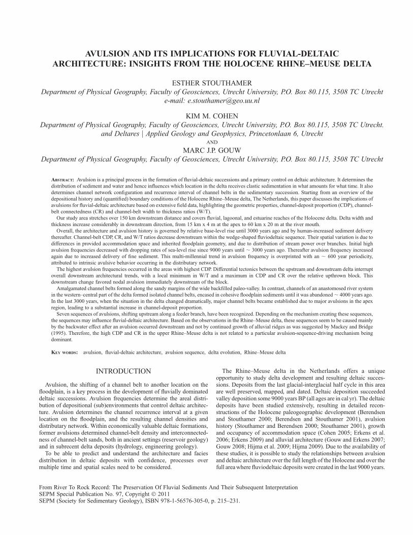
Outside channel belts, the thickness of the Holocene sequence isapproximately 2 m near the delta apex and just over 20 m at the presentriver mouth and coastal barrier. The upstream part of the delta isbordered by higher topography of sandy deposits of Pleistocene ageand relatively narrow (15–25 km wide). The downstream part of thedelta grades laterally into tidal-estuary and lagoonal Holocene coastal-plain environments, and widens considerably to ; 60 km (Fig. 2). Thedistance between the modern apex of the delta and the river mouth is ;
150 km, of which the last ; 50 km has a nearly zero gradient.
EVOLUTION OF THE HOLOCENE DELTA
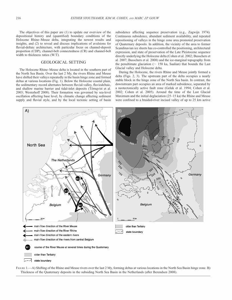
The transformation from incised-valley to deltaic and back-barriercoastal environments commenced 9000 years BP at the location of thepresent river mouth (near Rotterdam; Fig. 2). The Early Holocenetransition from valley to estuary occurred fast and was associated withrapid aggradation backfilling the paleovalley, to widening of the area offluvial deposition and to transformation of seasonally inundatedfloodplains to permanently wet floodbasin environments (Hijma et al.2009; Hijma 2009). These systems buried the network of channels of thepreceding valley and spread out over surrounding inherited topography(Fig. 3a). By 7000 yr BP, fluviodeltaic backfilling had reached the faultzone separating the lower and upper delta (Fig. 3b). At the same time thecoastal barrier had become established at the modern position and thetransgressed valley was transformed from a broad, shallow estuary to amore protected lagoon. Fluviodeltaic environments became establishedat the inland side of the lagoon. Tidal inlets prevailed closer to the
barrier, some of which received the Rhine and Meuse distributaries andfunctioned as estuaries. Coastal peat land prevailed between the fluvialchannels. By 6000 yr BP the lower delta had reached more or less itspresent size (e.g., Berendsen and Stouthamer 2000) (Fig. 3).
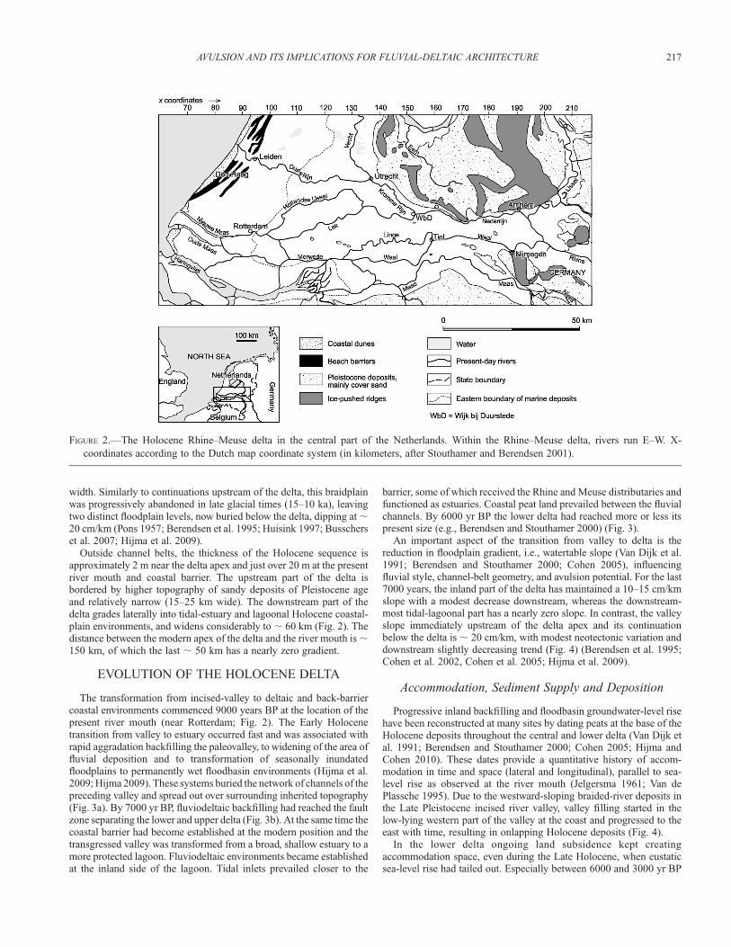
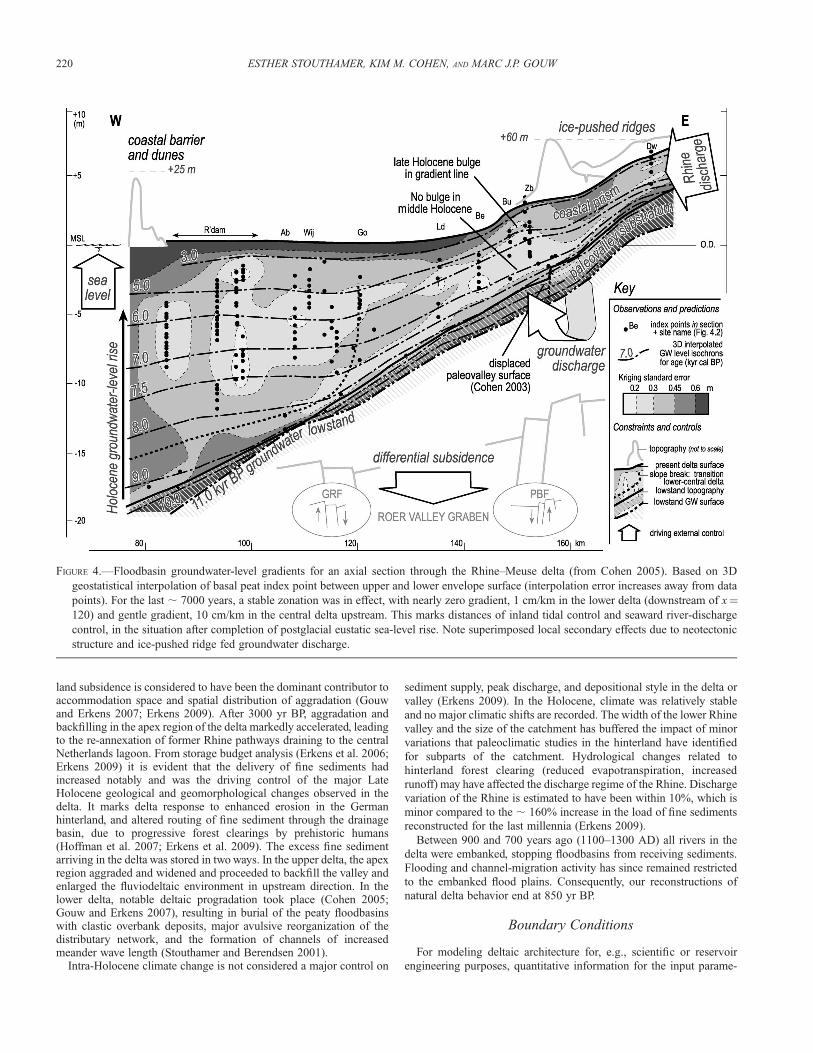
An important aspect of the transition from valley to delta is thereduction in floodplain gradient, i.e., watertable slope (Van Dijk et al.1991; Berendsen and Stouthamer 2000; Cohen 2005), influencingfluvial style, channel-belt geometry, and avulsion potential. For the last7000 years, the inland part of the delta has maintained a 10–15 cm/kmslope with a modest decrease downstream, whereas the downstream-most tidal-lagoonal part has a nearly zero slope. In contrast, the valleyslope immediately upstream of the delta apex and its continuationbelow the delta is ; 20 cm/km, with modest neotectonic variation anddownstream slightly decreasing trend (Fig. 4) (Berendsen et al. 1995;Cohen et al. 2002, Cohen et al. 2005; Hijma et al. 2009).
Accommodation, Sediment Supply and Deposition
Progressive inland backfilling and floodbasin groundwater-level risehave been reconstructed at many sites by dating peats at the base of theHolocene deposits throughout the central and lower delta (Van Dijk etal. 1991; Berendsen and Stouthamer 2000; Cohen 2005; Hijma andCohen 2010). These dates provide a quantitative history of accom-modation in time and space (lateral and longitudinal), parallel to sea-level rise as observed at the river mouth (Jelgersma 1961; Van dePlassche 1995). Due to the westward-sloping braided-river deposits inthe Late Pleistocene incised river valley, valley filling started in thelow-lying western part of the valley at the coast and progressed to theeast with time, resulting in onlapping Holocene deposits (Fig. 4).
In the lower delta ongoing land subsidence kept creatingaccommodation space, even during the Late Holocene, when eustaticsea-level rise had tailed out. Especially between 6000 and 3000 yr BP
FIGURE 2.—The Holocene Rhine–Meuse delta in the central part of the Netherlands. Within the Rhine–Meuse delta, rivers run E–W. X-
coordinates according to the Dutch map coordinate system (in kilometers, after Stouthamer and Berendsen 2001).
AVULSION AND ITS IMPLICATIONS FOR FLUVIAL-DELTAIC ARCHITECTURE 217
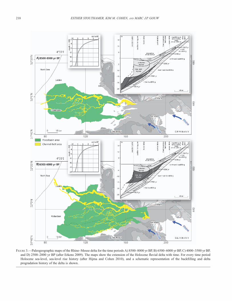
FIGURE 3.—Paleogeographic maps of the Rhine–Meuse delta for the time periods A) 8500–8000 yr BP, B) 6500–6000 yr BP, C) 4000–3500 yr BP,
and D) 2500–2000 yr BP (after Erkens 2009). The maps show the extension of the Holocene fluvial delta with time. For every time period
Holocene sea-level, sea-level rise history (after Hijma and Cohen 2010), and a schematic representation of the backfilling and delta
progradation history of the delta is shown.
218 ESTHER STOUTHAMER, KIM M. COHEN, AND MARC J.P. GOUW
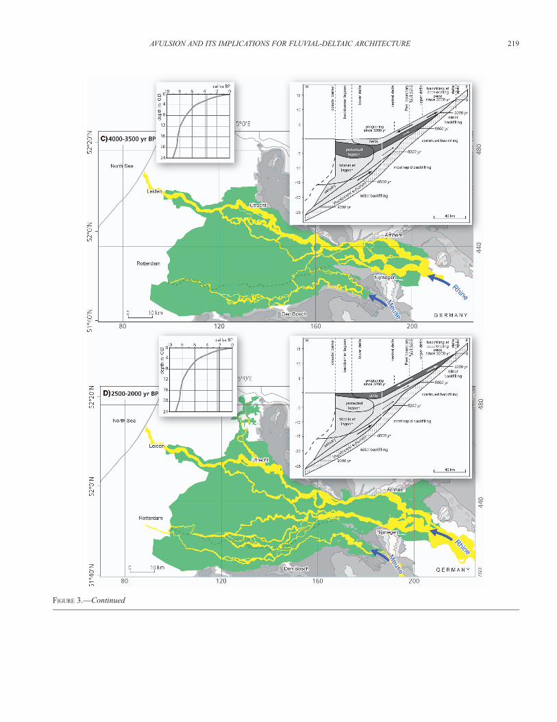
FIGURE 3.—Continued
AVULSION AND ITS IMPLICATIONS FOR FLUVIAL-DELTAIC ARCHITECTURE 219
land subsidence is considered to have been the dominant contributor toaccommodation space and spatial distribution of aggradation (Gouwand Erkens 2007; Erkens 2009). After 3000 yr BP, aggradation andbackfilling in the apex region of the delta markedly accelerated, leadingto the re-annexation of former Rhine pathways draining to the centralNetherlands lagoon. From storage budget analysis (Erkens et al. 2006;Erkens 2009) it is evident that the delivery of fine sediments hadincreased notably and was the driving control of the major LateHolocene geological and geomorphological changes observed in thedelta. It marks delta response to enhanced erosion in the Germanhinterland, and altered routing of fine sediment through the drainagebasin, due to progressive forest clearings by prehistoric humans(Hoffman et al. 2007; Erkens et al. 2009). The excess fine sedimentarriving in the delta was stored in two ways. In the upper delta, the apexregion aggraded and widened and proceeded to backfill the valley andenlarged the fluviodeltaic environment in upstream direction. In thelower delta, notable deltaic progradation took place (Cohen 2005;Gouw and Erkens 2007), resulting in burial of the peaty floodbasinswith clastic overbank deposits, major avulsive reorganization of thedistributary network, and the formation of channels of increasedmeander wave length (Stouthamer and Berendsen 2001).
Intra-Holocene climate change is not considered a major control on
sediment supply, peak discharge, and depositional style in the delta or
valley (Erkens 2009). In the Holocene, climate was relatively stable
and no major climatic shifts are recorded. The width of the lower Rhine
valley and the size of the catchment has buffered the impact of minor
variations that paleoclimatic studies in the hinterland have identified
for subparts of the catchment. Hydrological changes related to
hinterland forest clearing (reduced evapotranspiration, increased
runoff) may have affected the discharge regime of the Rhine. Discharge
variation of the Rhine is estimated to have been within 10%, which is
minor compared to the ; 160% increase in the load of fine sediments
reconstructed for the last millennia (Erkens 2009).
Between 900 and 700 years ago (1100–1300 AD) all rivers in the
delta were embanked, stopping floodbasins from receiving sediments.
Flooding and channel-migration activity has since remained restricted
to the embanked flood plains. Consequently, our reconstructions of
natural delta behavior end at 850 yr BP.
Boundary Conditions
For modeling deltaic architecture for, e.g., scientific or reservoir
engineering purposes, quantitative information for the input parame-
FIGURE 4.—Floodbasin groundwater-level gradients for an axial section through the Rhine–Meuse delta (from Cohen 2005). Based on 3D
geostatistical interpolation of basal peat index point between upper and lower envelope surface (interpolation error increases away from data
points). For the last ; 7000 years, a stable zonation was in effect, with nearly zero gradient, 1 cm/km in the lower delta (downstream of x¼120) and gentle gradient, 10 cm/km in the central delta upstream. This marks distances of inland tidal control and seaward river-discharge
control, in the situation after completion of postglacial eustatic sea-level rise. Note superimposed local secondary effects due to neotectonic
structure and ice-pushed ridge fed groundwater discharge.
220 ESTHER STOUTHAMER, KIM M. COHEN, AND MARC J.P. GOUW

ters and boundary conditions of delta formation are needed. Thisinformation should be deduced from field data as much as possible(e.g., Paola 2000). Here, we have summarized values quantified for theHolocene Rhine–Meuse delta (Table 1). See Gouw (2008) for a moreextensive overview.
AVULSION HISTORY
In the Holocene Rhine–Meuse delta various kinds of avulsionsoccurred: (1) avulsions of the main channels of the Rhine and Meuse,(2) avulsions of secondary channels, which are relatively smallchannels (usually , 250 m wide) of crevasse splays and the straightchannels of the anastomosing river system that was active in parts ofthe central delta between 8000 and 4000 yr BP, fed from the trunkchannel system along the northern delta rim, and (3) avulsionassociated to bay-head delta formation at distributary mouths intotidal estuaries (e.g., Hijma et al. 2009). The avulsion history and deltabuildup seem to be fully controlled by avulsions of the main channels,which are predominantly upstream driven. Therefore, here we presentthe avulsion history related to channel-belt avulsions in the fluvial-deltaic plain based on the detailed reconstruction of Stouthamer andBerendsen (2000, 2001).
The oldest documented avulsions of the Rhine–Meuse deltaoccurred 9000–8500 yr BP, in the Rotterdam area. From ; 8500 to
; 4500 yr BP (; 3700 14C yr BP), avulsion sites shifted upstream withsea-level rise, as part of deltaic backfilling (Figs. 5, 6). Thereafter,inland shifting halted. From ; 4500 to ; 3000 yr BP, avulsion siteswere controlled by the Peel Boundary Fault zone tectonic feature,which hosts four out of six of the nodal avulsion sites in the delta (i.e.,sites showing two or more avulsion events triggered at the samelocation; Stouthamer and Berendsen, 2000) (Fig. 6). After ; 3000 yrBP, the avulsion frequency increased significantly, and avulsion sitesoccurred all over the delta (Fig. 6). Between 3000 and 2000 yr BP, thenumber of coeval channels increased, after which it remained constant.This was the first time that a new main trunk distributary formed acrossthe Peel Horst.
Avulsion Frequency
Avulsion frequency, the number of avulsions per time interval, in theRhine–Meuse delta was reconstructed by Stouthamer and Berendsen(2001). They calculated frequencies including all identified 91 deltaicavulsion events inland of Rotterdam, including partial avulsionscreating secondary distributaries and full avulsion rerouting the maindelta channels, by plotting the ages of these avulsion events in a 14Cintensity histogram as a probability density function (for detaileddescription of this method, see Stouthamer and Berendsen 2001) (Fig.6). During initial rapid backfilling of the downstream part of the delta
TABLE 1.—Summary of boundary conditions for the formation of the Holocene Rhine-Meuse delta. Where feasible, temporal variation isaccounted for and separate values are given for the lower, central and upper delta (x coordinates 70–110; 110–160; 160–210 km, respectively).
Reference(s)
Climate Relatively stable climate in the temperate zone.
Minor climatic variability within the Holocene.
Effects on variation of discharge and sediment regime
minor compared to human-induced catchment impacts.
Erkens (2009)
Discharge Rhine: 2200 m3/s mean annual flow, 12.600 m3/s flood
of record (1926 AD)
Meuse: 260 m3/s mean annual flow, 3.000 m3/s flood
of record
20th century measurements by
Rijkswaterstaat
Sediment supply � 2.7 6 0.5 109 kg/yr
bed load: suspended load breakdown:
1:1 (Holocene-averaged value)
1:2 (average last 2000 years)
1:3.4 (modern value)
Erkens et al. (2006)
Erkens and Cohen (2009)
Basin subsidence rate Downstream of PBF (central, lower delta): 0.3 mm/yr
Upstream of PBF (upper delta): 0.1 mm/yr
Cohen (2003), Gouw (2008)
Floodbasin aggradation rate Lower delta: 3–0.3 mm/yr (7500–7000 yr BP: 3 mm/yr;
2500–1800 yr BP 0.3 mm/yr)
Upper delta: 1–0.3 mm/yr (5000–3000 yr BP: 1 mm/yr;
2500–1800 yr BP: 0.3 mm/yr)
Cohen (2005), Stouthamer and
Berendsen (2007)
Channel-belt aggradation rate Lower delta: , 0.4–4.2 mm/yr
Upper delta: , 0.3–2.8 mm/yr
Stouthamer (2001, 2005), Erkens and
Cohen (2009)
Floodplain width Lower delta: 60 km
Upper delta: 15 km
Floodplain length Apex to river mouth: 150 km
Holocene floodplain gradient Lower delta: 2–5 cm/km
Central delta: 10–15 cm/km
Upper delta: 15–20 cm/km
Van Dijk et al. (1991), Cohen (2005)
Paleo-valley gradient Lower delta: 20–30 cm/km
Central delta: 15–25 cm/km
Upper delta: 20–30 cm/km
Verbraeck (1984), Tornqvist (1998),
Stouthamer and Berendsen (2000),
Cohen et al. (2002), Hijma et al. 2009
PBF¼ Peel Boundary Fault zone.
AVULSION AND ITS IMPLICATIONS FOR FLUVIAL-DELTAIC ARCHITECTURE 221
(9000–7300 yr BP), the first channel-belt avulsions seem to lag theonset of floodbasin aggradation by some 800 years. A relatively highavulsion frequency occurred in the downstream delta between 8500 to7300 yr BP. Thereafter, avulsion frequency was low from 7300 to 3200yr BP. The maximum avulsion frequency observed between 8000 and7300 yr BP relates to the rapidly growing lateral and verticalaccommodation space at that time (see above). The relatively lowfrequency from 7300 to 3200 yr BP may be related to the steadilydropping rate of accommodation growth under decreasing rates of sea-level rise (Figs. 4, 6) and associated development of the coastal barrier.At this time the backfilling process continued but at a relatively slowrate. Since 6000 yr BP the backbarrier delta was relatively stable andcan be considered more or less in equilibrium (transgression ends,highstand begins). Abundant erosion-resistant peats (notably fromwoody Alnus swamps) resulted in the fixation of channels invading theback-barrier area (Stouthamer and Berendsen 2000; Van Asselen et al.2009). Especially, the landward side of the lagoonal delta had becomeunsuitable for the formation of new channels because of the occurrenceof extensive backswamps. This situation contrasts with the earliertransgressive stage of delta formation, when the environment waswetter and open reed marsh occurred (Phragmites peats, floodbasinlakes; Bos et al. 2009), encouraging avulsion. During the LateHolocene, the swamps became partially cleared, and then clay coveredduring the last peaks in avulsion frequency and ultimately embanked,successfully stopping further avulsion. The peaty flood basins also
induced low cross-valley gradients, unfavorable for successfulavulsion. Peat formation is an autogenic control, in this case,stabilizing the avulsion frequency.
The increase in avulsion frequency between 3200 and 1400 yr BP(reaching a maximum around 3000 yr BP) coincides with the increaseddelivery of fine sediment. It caused general rerouting of Rhinedischarge from the northern rim to the south–central part of the delta. Itis important to note that this maximum in avulsion frequency, unlikethe earlier maximum at 8500–7200 yr BP, occurred totally independentof accommodation space creation by sea-level rise (which by 3000 yrago had become nearly zero). The first peak, during transgression, wastriggered downstream; the second peak, well into the highstand, wastriggered upstream.
The avulsion frequency shows a periodicity of ; 600 years duringthe Holocene, which has been suggested to be an autogeniccharacteristic of the system (Stouthamer and Berendsen 2007). Aclue to the internal delta processes that cause avulsions to alternate infrequency at submillenial scale might be found in the recognition ofavulsion sequences. An avulsion sequence in its strict definitiongroups a series of avulsion sites that shift progressively upstreamalong a main channel, with a simultaneous decreasing interavulsionperiod (Mackey and Bridge 1995). Seven avulsion sequences mayhave occurred in the Holocene Rhine–Meuse delta, suggesting aperiodicity of ; 600 yr (Fig. 6). Each peak in the avulsion frequencycoincides with an avulsion sequence. When deltas indeed generate
FIGURE 5.—Location of avulsion sites in three time intervals during the Holocene. A) ; 8500–5000 yr BP: avulsion sites shifted eastward due to
relative sea-level rise, B) 5500–3000 yr BP: many avulsions occurred on faults bordering the Peel Block, and near the apex of the delta, and C)
3000–1000 yr BP: avulsion sites occurred all over the delta due to increased within-channel sedimentation and slightly increased discharge.
Between 1000 yr BP and the present, only few avulsions occurred, which were strongly influenced by humans. The position of the apex–
avulsion node coincides with the long-term tectonic hinge line and occurs in a relatively confined reach of the lower valley (dissected ice-
marginal topography). Avulsion that occurred upstream of the Peel Boundary Fault zone in many cases only created secondary channels that
rejoined the main distributary instead of crossing the Peel Horst independently. Notably, the largest nodal site (WbD 6 avulsions in 3200 years;
Stouthamer 2001) was fed by the Rhine trunk channel in trapped position between the Peel Horst highest block and the ice-marginal
topography (Berendsen and Stouthamer 2000; Cohen 2003). TF¼Tegelen Fault, PBF¼Peel Boundary Fault, and WbD¼Wijk bij Duurstede
(after Stouthamer and Berendsen 2000).
222 ESTHER STOUTHAMER, KIM M. COHEN, AND MARC J.P. GOUW
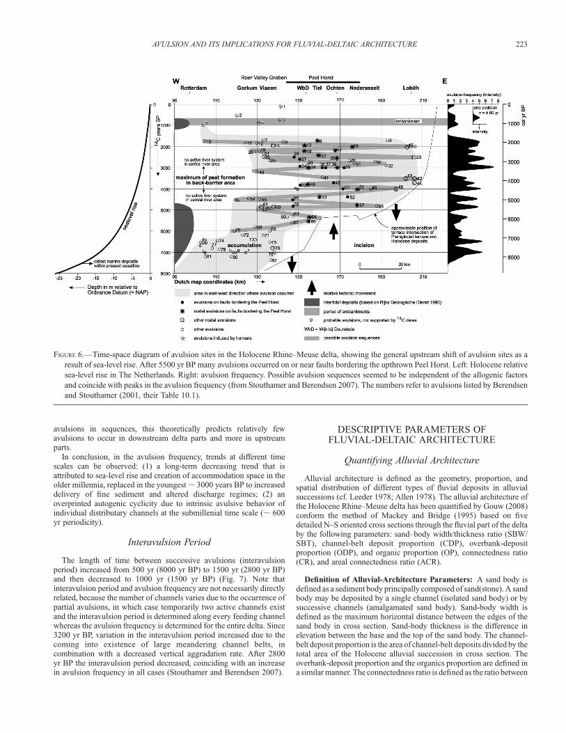
avulsions in sequences, this theoretically predicts relatively fewavulsions to occur in downstream delta parts and more in upstreamparts.
In conclusion, in the avulsion frequency, trends at different timescales can be observed: (1) a long-term decreasing trend that isattributed to sea-level rise and creation of accommodation space in theolder millennia, replaced in the youngest ; 3000 years BP to increaseddelivery of fine sediment and altered discharge regimes; (2) anoverprinted autogenic cyclicity due to intrinsic avulsive behavior ofindividual distributary channels at the submillenial time scale (; 600yr periodicity).
Interavulsion Period
The length of time between successive avulsions (interavulsionperiod) increased from 500 yr (8000 yr BP) to 1500 yr (2800 yr BP)and then decreased to 1000 yr (1500 yr BP) (Fig. 7). Note thatinteravulsion period and avulsion frequency are not necessarily directlyrelated, because the number of channels varies due to the occurrence ofpartial avulsions, in which case temporarily two active channels existand the interavulsion period is determined along every feeding channelwhereas the avulsion frequency is determined for the entire delta. Since3200 yr BP, variation in the interavulsion period increased due to thecoming into existence of large meandering channel belts, incombination with a decreased vertical aggradation rate. After 2800yr BP the interavulsion period decreased, coinciding with an increasein avulsion frequency in all cases (Stouthamer and Berendsen 2007).
DESCRIPTIVE PARAMETERS OFFLUVIAL-DELTAIC ARCHITECTURE
Quantifying Alluvial Architecture
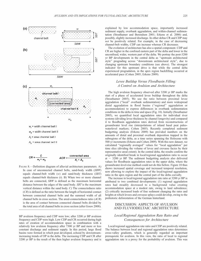
Alluvial architecture is defined as the geometry, proportion, andspatial distribution of different types of fluvial deposits in alluvialsuccessions (cf. Leeder 1978; Allen 1978). The alluvial architecture ofthe Holocene Rhine–Meuse delta has been quantified by Gouw (2008)conform the method of Mackey and Bridge (1995) based on fivedetailed N–S oriented cross sections through the fluvial part of the deltaby the following parameters: sand–body width/thickness ratio (SBW/SBT), channel-belt deposit proportion (CDP), overbank-depositproportion (ODP), and organic proportion (OP), connectedness ratio(CR), and areal connectedness ratio (ACR).
Definition of Alluvial-Architecture Parameters: A sand body isdefined as a sediment body principally composed of sand(stone). A sandbody may be deposited by a single channel (isolated sand body) or bysuccessive channels (amalgamated sand body). Sand-body width isdefined as the maximum horizontal distance between the edges of thesand body in cross section. Sand-body thickness is the difference inelevation between the base and the top of the sand body. The channel-belt deposit proportion is the area of channel-belt deposits divided by thetotal area of the Holocene alluvial succession in cross section. Theoverbank-deposit proportion and the organics proportion are defined ina similar manner. The connectedness ratio is defined as the ratio between
FIGURE 6.—Time-space diagram of avulsion sites in the Holocene Rhine–Meuse delta, showing the general upstream shift of avulsion sites as a
result of sea-level rise. After 5500 yr BP many avulsions occurred on or near faults bordering the upthrown Peel Horst. Left: Holocene relative
sea-level rise in The Netherlands. Right: avulsion frequency. Possible avulsion sequences seemed to be independent of the allogenic factors
and coincide with peaks in the avulsion frequency (from Stouthamer and Berendsen 2007). The numbers refer to avulsions listed by Berendsen
and Stouthamer (2001, their Table 10.1).
AVULSION AND ITS IMPLICATIONS FOR FLUVIAL-DELTAIC ARCHITECTURE 223

the length of horizontal contact between connected channel belts andthe summed width of all channel belts in cross section. Areal con-nectedness ratio is the area of contact between connected channel beltsdivided by the total area of all channel belts in cross section (Fig. 8).
Architectural Configuration
The main river channels in the Rhine–Meuse delta for a long timesince the start of deltaic aggradation tended to adhere to the sandymargins of the wide backfilled paleo-valley. The presence ofnoncohesive banks at the margins of the delta resulted in meanderingdistributaries, with high channel sinuosities and relatively widechannel belts. Locally, these channels formed isolated channel belts,but over a considerable length they formed amalgamated channel-beltcomplexes (Gouw 2008). In contrast, channels in the western–centralpart of the delta formed isolated channel belts, encased in cohesivefloodplain sediments. This multistage anastomosed river system ischaracterized by relatively small (, 250 m) straight channels andwidespread crevassing until it was abandoned ; 4000 yr BP. In the last3000 years, when the situation in the central delta changeddramatically, major channel belts became established, due to majoravulsions . 60 km upstream in the apex region and at the central fault-zone nodal sites. As these channels (‘‘Krimpen system’’; cf. Berendsen1982) took over discharge from the former trunk channel along thenorthern delta rim (‘‘Utrecht system’’; cf. Berendsen 1982), theyformed relatively wide, confined-meandering channel belts (Makaske1998; Hesselink et al. 2003; Gouw 2008). This altered the alluvialarchitecture drastically, raising CDP from , 0.5 before 3000 yr BP to. 0.5 after 3000 yr BP (Gouw 2008).
In the eastern, confined part of the delta, meandering channelbelts existed already since the onset of aggradation due to relative
sea-level rise. This is due to the relative abundance of easily erodiblepaleovalley sand at shallow depth and the relatively confined deltafloodplain.
In the lowermost part of the delta, fluviodeltaic channels postdatingtransgression of the area are mostly lacking. Tidal-inlet channelsystems and estuaries prevail (Hijma et al. 2009), with one majorexception in the very north of the delta, which is the fluviotidal ’’OudeRijn’’ outlet channel belt (Fig. 2). Channels of the Rhine and the Meusemerged into broad tidal estuaries at a considerable distance (; 30 km)inland of the North Sea coast line.
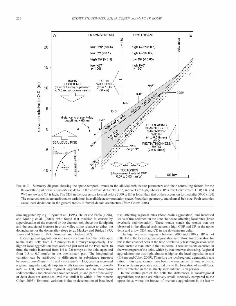
Distinct spatial and temporal trends have been recognized in thealluvial architecture (Gouw 2007; Gouw 2008). Width/thickness (W/T) ratios decrease by a factor of ; 4 in the downstream direction.Channel-deposit proportion (CDP) decreases from ; 0.7 upstream to; 0.3 downstream. Organic-matter proportion (OP) increases fromless than 0.05 in the upstream part of the delta to more than 0.25 in thedownstream delta. Overbank-deposit proportion (ODP) is approxi-mately constant (0.4). The connectedness ratio (CR) is ; 0.25upstream, which is approximately two times larger than in thedownstream part of the delta. These trends are attributed to variations inavailable accommodation space, floodplain geometry, and channel-beltsize (Gouw 2008). For example, channel belts tend to narrow in adownstream direction, which reduces W/T, CDP, and CR (Fig. 9).
AVULSIONS CONTROLLING FLUVIAL-DELTAICARCHITECTURE
Avulsion Frequency and Channel-Deposit Proportion
In the Rhine–Meuse delta the avulsion frequency appears to bepositively correlated with CDP and CR (Gouw 2008). Before 3200 yr
FIGURE 7.—The interavulsion period of channel belts in the Rhine–Meuse delta (from Stouthamer and Berendsen, 2007). Interavulsion period
increased from 500 yr (8000 yr BP) to 1500 yr (2800 yr BP) and then decreased to 1000 yr (1500 yr BP). Since 3200 yr BP variation in the
interavulsion period increased. The numbers refer to avulsions listed by Berendsen and Stouthamer (2001, their Table 10.1).
224 ESTHER STOUTHAMER, KIM M. COHEN, AND MARC J.P. GOUW
BP avulsion frequency and CDP were low; after 3200 yr BP avulsionfrequency and CDP were high. Low CDP and CR occurred during highrates of creation of accommodation space in combination with arelatively low avulsion frequency after 7300 yr BP and more or lessconstant discharge and sediment supply. In this period, large floodbasins were formed in which peat developed, echoed by downstream-increasing trends of OP in the delta. The increasing CDP and CR after3200 yr BP is the result of the then higher avulsion frequency and is
explained by low accommodation space, importantly increasedsediment supply, overbank aggradation, and within-channel sedimen-tation (Stouthamer and Berendsen 2001; Erkens et al. 2006) and,possibly, slightly increased discharge. In other deltas CR and CDP maynot be positively related. For example, in the case of decreasingchannel-belt widths, CDP can increase whereas CR decreases.
The evolution of architecture has also a spatial component. CDP andCR are higher in the confined eastern part of the delta and lower in theunconfined, wider, western part of the delta. We portray the post-3200yr BP developments in the central delta as ‘‘upstream architecturalstyle’’ prograding across ‘‘downstream architectural style’’, due tochanging upstream boundary conditions (see above). The strongestindicator for this upstream drive is that while the central deltaexperienced progradation, in the apex region backfilling occurred ataccelerated pace (Cohen 2005; Erkens 2009).
Levee Buildup Versus Floodbasin Filling:
A Control on Avulsion and Architecture
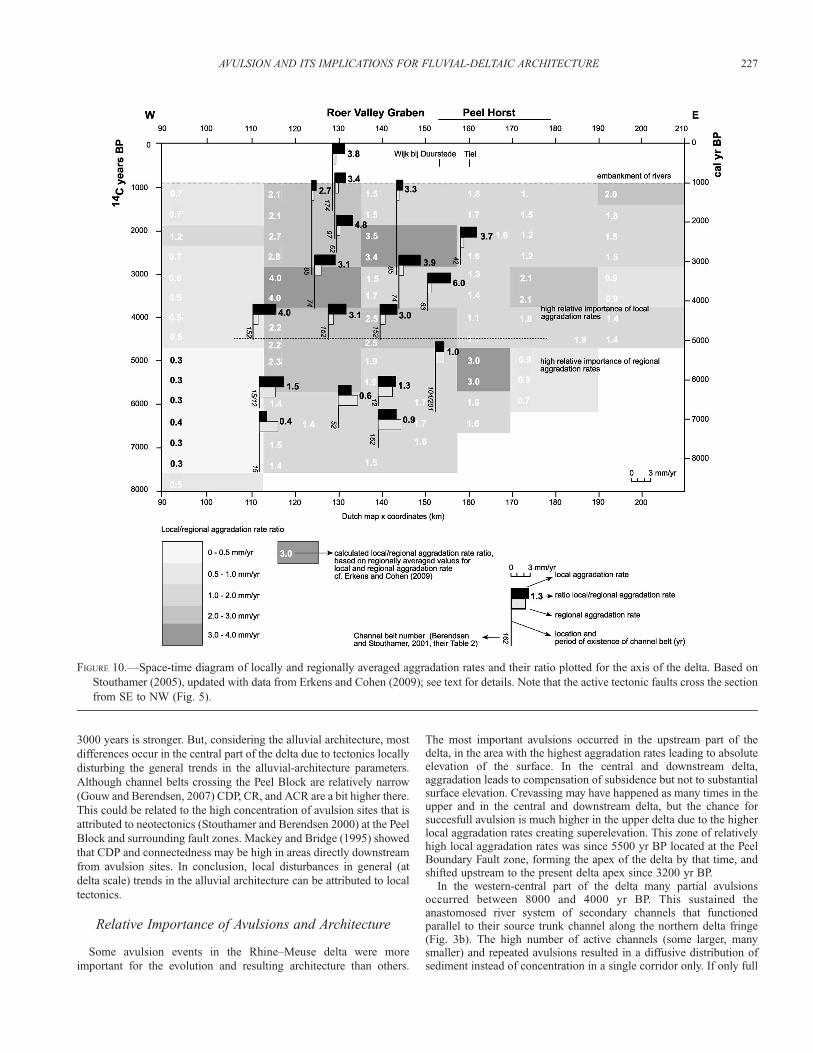
The high avulsion frequency observed after 3200 yr BP marks thestart of a phase of accelerated levee buildup throughout the delta(Stouthamer 2005). We use the ratio between proximal leveeaggradation (‘‘local’’ overbank sedimentation) and more widespreaddistal aggradation in flood basins (‘‘regional’’ aggradation oraccommodation) to express differences in overbank sedimentationconditions in the delta in time and space (Fig. 10). Initially (Stouthamer2005), we quantified local aggradation rates for individual riversystems (dividing levee thickness by channel longevity) and comparedit to floodbasin aggradation rates derived from reconstructions ofgroundwater level rise (interpolations of inland basal peat paleo-waterlevel markers; Cohen 2005). Recently completed sedimentbudgetting analysis (Erkens 2009) has provided numbers on theamounts of distal and proximal overbank deposition trapped in thesubregions of the delta, as a time series spanning the Holocene with500 yr increments (Erkens and Cohen 2009). With this new dataset, wecalculated ‘‘regionally averaged’’ values for ‘‘local aggradation’’ pertime slice (dividing the volume of levee and crevasse facies by theirrepresentative areal extent). In the central delta, the results confirm theoriginally identified break in local/regional aggradation ratio to occurat ; 3200 yr BP. The sediment budgetting analysis also deliveredvalues for floodbasin aggradation rates in the upper delta, where thegroundwater-level-rise method could not do this before. Figure 10 thusshows increased spatial coverage and increased temporal resolution,now allowing to explore the impact of the local/regional aggradationratio in the apex region and the central part of the delta coevally.
The increase in local/regional aggradation rate ratio at 3200 yr BP isattributed to two combined developments: (1) regional aggradationrates had steadily decreased to a background value creatingaccommodation space at a modest rate, owing to land subsidence;(2) critically increased loads of fine sediment changing the rates andheights at which levees and crevasse splays could develop, owing to theprehistoric deforestation of the German hinterland.
DISCUSSION: ASPECTS OF AVULSIONAND FLUVIODELTAIC ARCHITECTURE
Local/Regional Aggradation Rate Ratio and
Consequences for Architecture
Local/regional aggradation rate ratio and CDP are positively related.The balance between local and regional aggradation rates determinescross-valley gradients, which is generally regarded an importantprerequisite for avulsion. In this view, the ratio of local to regionalaggradation rate is a proxy for the probability of avulsion. This was
FIGURE 8.—Definition diagram of alluvial architecture parameters. A)
In case of unconnected channel belts, sand-body width (SBW)
equals channel-belt width (w) and sand-body thickness (SBT)
equals channel-belt thickness (t). B) When two or more channel
belts are connected, SBW is defined as the maximum horizontal
distance between the edges of the sand body. SBT is the maximum
vertical distance within the sand body. C) The connectedness ratio
(CR) is defined as the ratio between the length of horizontal contact
between connected channel belts and the summed width of all
channel belts in cross section. The areal-connectedness ratio (ACR)
is the area of contact between connected channel belts divided by
the total area of all channel belts in cross section (after Gouw 2008).
AVULSION AND ITS IMPLICATIONS FOR FLUVIAL-DELTAIC ARCHITECTURE 225
also suggested by, e.g., Bryant et al. (1995), Heller and Paola (1996),and Mohrig et al. (2000), who found that avulsion is caused bysuperelevation of the channel or the channel belt above the floodplainand the associated increase in cross-valley slope relative to either thedownchannel or the downvalley slope (e.g., Mackey and Bridge 1995;Jones and Schumm 1999; Tornqvist and Bridge 2002).
Local/regional aggradation rate ratios decrease from the delta apexto the distal delta from 1–2 mm/yr to 0–1 mm/yr respectively. Thehighest local aggradation rates occurred just west of the Peel Horst. Intime, the ratios increased from 1.4 to 2.0 mm/yr at the delta apex andfrom 0.5 to 0.7 mm/yr in the downstream part. The longitudinalvariation can be attributed to differences in subsidence (greatestbetween x coordinate¼110 and x coordinate¼155, causing increasedregional aggradation), delta-plain width (narrow upstream, x coordi-nate ¼ 160, increasing regional aggradation due to floodbasinsedimentation) and elevation above sea level (inland part of the valleyor delta does not sense sea-level rise until it is within a few meters;Cohen 2005). Temporal variation is due to deceleration of base-level
rise, affecting regional rates (flood-basin aggradation) and increasedloads of fine sediment in the Late Holocene, affecting local rates (leveeoverbank sedimentation). These trends match the trends that areobserved in the alluvial architecture: a high CDP and CR in the upperdelta and a low CDP and CR in the downstream delta.
The high avulsion frequency between 8000 and 7300 yr BP is notreflected in the local/regional aggradation rate ratios. An explanation forthis is that channel belts at the time of relatively fast transgression weremore unstable than later in the Holocene. These avulsions occurred inthe western part of the delta, which by that time was drowning. Regionalaggradation rate was high, almost as high as the local aggradation rate(Erkens and Cohen 2009). Therefore the local/regional aggradation rateratio, in this case, cannot have been the mechanism driving avulsion.These avulsions probably occurred due to the formation of mouth bars.This is reflected in the relatively short interavulsion periods.
In the central part of the delta the differences in local/regionalaggradation rate ratio are relatively small, especially compared to theupper delta, where the impact of overbank aggradation in the last ;
FIGURE 9.—Summary diagram showing the spatio-temporal trends in the alluvial-architecture parameters and their controlling factors for the
fluviodeltaic part of the Rhine–Meuse delta. In the upstream delta CDP, CR, and W/T are high, whereas OP is low. Downstream, CDP, CR, and
W/T are low and OP is high. The CDP in the succession formed before 3000 yr BP is lower than that of the succession formed after 3000 yr BP.
The observed trends are attributed to variations in available accommodation space, floodplain geometry, and channel-belt size. Fault tectonics
cause local deviations in the general trends in fluvial-deltaic architecture (from Gouw 2008).
226 ESTHER STOUTHAMER, KIM M. COHEN, AND MARC J.P. GOUW
3000 years is stronger. But, considering the alluvial architecture, most
differences occur in the central part of the delta due to tectonics locally
disturbing the general trends in the alluvial-architecture parameters.
Although channel belts crossing the Peel Block are relatively narrow
(Gouw and Berendsen, 2007) CDP, CR, and ACR are a bit higher there.
This could be related to the high concentration of avulsion sites that is
attributed to neotectonics (Stouthamer and Berendsen 2000) at the Peel
Block and surrounding fault zones. Mackey and Bridge (1995) showed
that CDP and connectedness may be high in areas directly downstream
from avulsion sites. In conclusion, local disturbances in general (at
delta scale) trends in the alluvial architecture can be attributed to local
tectonics.
Relative Importance of Avulsions and Architecture
Some avulsion events in the Rhine–Meuse delta were more
important for the evolution and resulting architecture than others.
The most important avulsions occurred in the upstream part of thedelta, in the area with the highest aggradation rates leading to absoluteelevation of the surface. In the central and downstream delta,aggradation leads to compensation of subsidence but not to substantialsurface elevation. Crevassing may have happened as many times in theupper and in the central and downstream delta, but the chance forsuccesfull avulsion is much higher in the upper delta due to the higherlocal aggradation rates creating superelevation. This zone of relativelyhigh local aggradation rates was since 5500 yr BP located at the PeelBoundary Fault zone, forming the apex of the delta by that time, andshifted upstream to the present delta apex since 3200 yr BP.
In the western-central part of the delta many partial avulsionsoccurred between 8000 and 4000 yr BP. This sustained theanastomosed river system of secondary channels that functionedparallel to their source trunk channel along the northern delta fringe(Fig. 3b). The high number of active channels (some larger, manysmaller) and repeated avulsions resulted in a diffusive distribution ofsediment instead of concentration in a single corridor only. If only full
FIGURE 10.—Space-time diagram of locally and regionally averaged aggradation rates and their ratio plotted for the axis of the delta. Based on
Stouthamer (2005), updated with data from Erkens and Cohen (2009); see text for details. Note that the active tectonic faults cross the section
from SE to NW (Fig. 5).
AVULSION AND ITS IMPLICATIONS FOR FLUVIAL-DELTAIC ARCHITECTURE 227

avulsions (spawning channels that take over the entire discharge andcause complete abandonment of the old channel) are considered, thefrequency of avulsion is much reduced (Stouthamer and Berendsen2001). This reduction occurred under stable supply of fines andbedload (Erkens and Cohen 2009), delivered by the Rhine from adensely vegetated drainage basin (e.g., Erkens et al. 2009). Eventually,such a single-corridor situation came into existence around 4000 yr BP,but it was to be sustained only briefly and did not survive the 3000 yrBP changes.
Style of Avulsion and Architecture
Alluvial architecture in the Rhine–Meuse delta can be thought of asbeing the result of avulsion style. Examples of differing avulsion styleare (1) avulsion by diversion into the flood basin, creating mainly singlechannel belts; (2) avulsion by reoccupation of an abandoned channelbelt, creating stacked channel belts and; (3) avulsion by annexation of anew flood basin, formerly outside the delta, creating a new delta. Aslanand Blum (1999) related avulsion style to the stage of valley filling,based on field data of the Trinity, Nueces, and Colorado Rivers, Texas,USA. They concluded that channel reoccupation is most prevalentduring early and late stages of valley filling when aggradation rates arelow, due to low sediment supply or limited accommodation space. Onthe contrary, avulsion by diversion into the floodbasin and hence theformation of new channel belts occurs during periods of rapidaccommodation-space creation and valley filling. This relationshipwas also found by Morozova and Smith (2000) for the SaskatchewanRiver, Canada. In the Rhine–Meuse delta this also seems to apply; thenumber of reoccupations was low during rapid sea-level rise prior to5000 yr BP and high during slow sea-level rise (Stouthamer 2005).
High avulsion frequencies do not necessarily lead to highreoccupation frequencies. In the initial stages of delta development,avulsion frequency was high but reoccupation frequency was low.Excessive reoccupation occurred only where main channel belts fixedthemselves along the delta rims. In that situation, channel belts wereeither rejuvenated soon after abandonment or not at all. These regionsare characterized stratigraphically by the nearby coexistence of isolatedand amalgamated stacked channel belts, tied to either natural leveedeposits at multiple levels or exceptionally thick (. 3 m) natural-leveedeposits, whereas regions of other avulsion style have not (Stouthamer2005).
Avulsion Sequences and Architecture
The occurrence of avulsion sequences that are observed in theRhine–Meuse delta, but were also found in the Po, Kosi, Yellow(Mackey and Bridge 1995), and Burdekin river deltas (Fielding et al.2006) and in experiments (Hoyal and Sheets 2009), can be explained inthree ways. The first way (1) is by continuous growth of alluvial ridges,which steadily increases cross-valley slopes, and predicts chances foravulsion to be largest along matured sections of a channel belt. Thenewly formed channel downstream of a first avulsion node is less likelyto avulse than the upstream feeding channel, because it has immature,low natural levees, far below the avulsion threshold. This favors nextavulsions to occur upstream past avulsions, leading to an avulsionsequence moving upstream towards the apex of the delta, where itterminates. A new sequence is then triggered by a next ‘‘first’’ avulsionin the downstream part of the delta (Mackey and Bridge 1995). Thismechanism inevitably leads to decreasing interavulsion periods duringa sequence. An alternative explanation (2) attributes the hydraulicbackwater effect, and morphological adaption by sedimentationeffecting response to it, an upstream avulsion-triggering role (e.g.,Kleinhans et al. 2010). When an avulsion is ongoing, the flow velocityin the channel upstream of the active bifurcation is reduced and theriver raises its water level (adaptation length ¼ channel depth/water
level slope). This hydraulic backwater effect affects a river of the sizeof the Rhine over some ten to twenty kilometers of upstream distance,somewhat helped by the bed-level adaption that it triggers. Along thisreach it increases the frequency of levee overtopping and, hence,avulsion. This favours next avulsions to occur upstream past avulsions,leading to an avulsion sequence moving upstream towards the apex ofthe delta, where it terminates. A third idea (3) is that avulsionsequences are driven by allogenic processes rather than the autogenicmechanisms of explanation 1 and 2. During the transgression (9000–6000 yr BP) it is obvious from the replacement of fluvial by intertidalenvironments that avulsion locations were pushed upstream by externaldownstream forcing. During the human-overprinted youngest 3000years, increased sediment load accelerated natural levee buildup,especially in the relatively confined upstream part of a delta. It hasincreased avulsion frequency and decreased interavulsion period in thisarea, and the upstream shifting of the delta apex can be seen as theculmination of an external-upstream forced avulsion sequence.
The extensive dataset of the Rhine–Meuse delta, covering 9000 yearsof delta formation, allows to balance the various hypotheses. Of theautogenic explanations, which need not be mutually exclusive,explanation 2 seems to apply to all avulsion sequences in the Rhine–Meuse delta. Explanation 1 implies a decreasing interavulsion periodduring an avulsion sequence, but that was the case in half of the avulsionsequences only. In the other half, interavulsion period did not decrease,but even increased (Stouthamer and Berendsen 2007). Explanation 3involves major autogenic changes, and can explain particularities andtiming of specific avulsion sequences, but certainly not all sequencesare driven by the same forcing. Avulsion sequences in the Rhine–Meusedelta occur with a more or less constant periodicity of ; 600 years andare recognized to have occurred since 6800 yr BP (Fig. 6).
The occurrence of avulsion sequences driven by mechanism 1 in thepast has been used to explain the relatively high CDP and CR in theupper part of, e.g., the Yellow River delta (Mackey and Bridge 1995).We think that the high CDP and CR in the upper Rhine–Meuse delta isnot related to a particular avulsion-sequence-driving mechanism beingdominant. The inherited confined geometry of this part of the delta andthe Late Holocene allogenically increased suspended load that ittrapped are more important to the Rhine delta architecture and theyoungest part of its contained avulsion sequences.
SUMMARY AND CONCLUSIONS
The most important observations and thoughts regarding theHolocene evolution of the Rhine–Meuse delta and the relationshipbetween avulsion and fluviodeltaic architecture are summarized below.
� The formation of the present-day delta occurred in three phases: (1)backfilling of the incised river valley due to eustasy and subsidence(eustasy þ subsidence, ; 9000–4500 yr BP; subsidence, ; 4500–3000 yr BP), (2) delta progradation and apex-region expansion, ataccelerating rate due to increase in sediment supply (3000–1000 yrBP), and (3) Human-controlled embanked stage (last 1000 years)without sedimentation in the cultivated floodbasins.
� In the avulsion frequency, trends at different time scales occurred: (1)a long-term decreasing trend, attributed to sea-level rise and creationof accommodation space in the Early and Mid Holocene,counteracted in the youngest ; 3000 years by increased deliveryof fine sediment and slightly altered discharge regimes; (2) anoverprinted autogenic cyclicity due to intrinsic avulsive behavior ofindividual distributary channels at the submillennial time scale (;600 yr periodicity).
� It is important to note that the first peak in the avulsion frequency,during transgression, was triggered downstream and the secondpeak, well into the high stand, was triggered upstream.
228 ESTHER STOUTHAMER, KIM M. COHEN, AND MARC J.P. GOUW
� Antecedent topography and fault-zone neotectonics together causedlocal overprinted effects in the avulsion history and hence deltaformation and architecture.
� W/T ratios, CDP, and CR decrease in a downstream direction,whereas OP increases and ODP is approximately constant. Thesetrends are attributed to variations in available accommodation space,floodplain geometry, and channel-belt size. At the sandy margins ofthe backfilled paleovalley the main river channels tended to adhere,resulting in relatively wide, high-sinuosity meandering channel beltsforming amalgamated channel-belt complexes. In the western-central part of the delta isolated, relatively small channel belts,encased in cohesive floodplain sediments, formed. During the LateHolocene, after 3000 yr BP, major avulsions occurred in the apexregion and at the central fault-zone nodal sites, resulting in theformation of major wide, confined-meandering channel belts,inreasing CDP drastically.
� Avulsion frequency, CDP, and CR are positively related. Before 3200yr BP avulsion frequency, CDP, and CR were low, whereas after3200 yr BP avulsion frequency, CDP, and CR were high. The lowCDP and CR occurred during high rates of creation of accommo-dation space in combination with a relatively low avulsion frequencyafter 7300 yr BP and constant discharge and sediment supply. Theincreasing CDP and CR after 3200 yr BP is the result of theincreased avulsion frequency in combination with limited accom-modation space, importantly increased sediment supply, overbankaggradation, and within-channel sedimentation, and, possibly,slightly increased discharge. Spatially, CDP and CR are higher inthe confined eastern part of the delta and lower in the unconfined,wider, western part of the delta.
� Local/regional aggradation rate ratio, determining cross-valleygradients, and CDP are positively related. Local/regional aggrada-tion rate ratios decrease from the delta apex to the distal delta, withthe highest local aggradation rates occurring just west of the PeelHorst. The longitudinal variation can be attributed to differences insubsidence, delta-plain width, and elevation above sea level, andtemporal variation is due to deceleration of base-level rise affectingregional flood-basin aggradation rates and increased loads of finesediment in the Late Holocene affecting local levee overbanksedimentation rates. These trends match the trends that are observedin the alluvial architecture—a high CDP and CR in the upper deltaand a low CDP and CR in the lower delta—because there is a directrelationship between local/regional aggradation rate ratio, avulsionfrequency, and CDP and CR.
� The most important avulsions of the main channels of the Rhine andMeuse determining delta formation occurred in the upstream part ofthe delta, the area with the highest aggradation rates leading toabsolute elevation of the surface. In the central and downstreamdelta, aggradation leads to compensation of subsidence but not tosubstantial surface elevation. The chance for succesfull avulsiontherefore is much higher in the upper delta. The zone of relativelyhigh local aggradation rates was since 5500 yr BP located at the PeelBoundary Fault zone, forming the apex of the delta by that time, andshifted upstream to the present delta apex since 3200 yr BP.Downstream of the fault zone, the high number of many secondarysmall channels and repeated partial avulsions resulted in a diffusivedistribution of sediment instead of concentration in a single corridor.
� Avulsion style changed between stages of valley filling. Avulsion bydiversion into the flood basin created mainly single-channel beltsduring the transgression phase (9000–6000 yr BP), avulsion byreoccupation of abandoned channel belts created stacked channelbelts during highstand (6000–3000 yr BP), and avulsion byannexation of new flood basin during the last 3000 years, under
human-increased fine sediment loads, dramatically shifted the Rhinedischarge from NW to SW, completely changing the distributarynetwork and affecting the entire delta.
� Avulsion sequences, of which seven were recognized in the Rhine–Meuse delta, seem to be caused mainly by the backwater effect andnot by increasing cross-valley slopes upstream of avulsion locations,the mechanism by which the relatively high CDP and CR in theupper part of, e.g., the Yellow River delta was explained (Mackeyand Bridge 1995). We think that the high CDP and CR in the upperRhine–Meuse delta is not related to a particular avulsion-sequence-driving mechanism being dominant. The inherited confinedgeometry of this part of the delta and the Late Holocene allogenicallyincreased suspended load that it trapped are more important to theRhine delta architecture and the youngest part of its containedavulsion sequences.
ACKNOWLEDGMENTS
This paper benefited from thorough and constructive reviews byJohn Swenson and Brian Willis, and from discussions with co-workersGilles Erkens and Maarten Kleinhans.
REFERENCES
ALLEN, J.R.L., 1978, Studies in fluviatile sedimentation: an exploratory
quantitative model for the architecture of avulsion-controlled alluvial suites:
Sedimentary Geology, v. 21, p. 129–147.
ASLAN, A., AND BLUM, M.D., 1999, Contrasting styles of Holocene avulsion,
Texas Gulf Coastal Plain, USA, in Smith, N.D., and Rogers, J., eds., Fluvial
Sedimentology VI: International Association of Sedimentologists, Special
Publication 28, p. 193–209.
BERENDSEN, H.J.A., 1982, De genese van het landschap in het zuiden van de
provincie Utrecht: een fysisch-geografische studie: Published Ph.D. Thesis,
Utrecht University, Utrechtse Geografische Studies 25, 255 p.
BERENDSEN, H.J.A., 2008, De vorming van het land: Inleiding in de geologie en
de geomorfologie: Assen, Van Gorcum, 410 p.
BERENDSEN, H.J.A., AND STOUTHAMER, E., 2000, Late Weichselian and Holocene
palaeogeographic evolution of the Rhine–Meuse delta, The Netherlands:
Palaeogeography, Palaeoclimatology, Palaeoecology, v. 161, p. 311–335.
BERENDSEN, H.J.A., AND STOUTHAMER, E., 2001, Palaeogeographic Development
of the Rhine–Meuse Delta, The Netherlands: Assen, Van Gorcum, 270 p.
BERENDSEN, H.J.A., HOEK, W.Z., AND SCHORN, E.A., 1995, Late Weichselian and
Holocene river channel changes of the Rivers Rhine and Meuse in the Central
Netherlands (Land van Maas en Waal), in Frenzel, B., ed., European River
Activity and Climate Change during the Lateglacial and Early Holocene:
European Science Foundation Project European Palaoklimaforschung /
Paleoclimate Research 14, special issue, p. 151–171.
BOS, I.J., FEIKEN H., BUNNIK, F., AND SCHOKKER, J., 2009, Influence of organics
and clastic lake fills on distributary channel processes in the distal Rhine–
Meuse delta (The Netherlands): Palaeogeography, Palaeoclimatology, Palae-
oecology, v. 284, p. 355–374.
BRYANT, M., FALK, P., AND PAOLA, C., 1995, Experimental study of avulsion
frequency and rate of deposition: Geology, v. 23, p. 365–368.
BUSSCHERS, F.S., KASSE, C., VAN BALEN, R.T., VANDENBERGHE, J., COHEN, K.M.,
WEERTS, H.J.T., WALLINGA, J., JOHNS, C., CLEVERINGA, P., AND BUNNIK, F.P.M.,
2007, Late Pleistocene evolution of the Rhine–Meuse system in the southern
North Sea basin. Imprints of climate change, sea-level oscillation and glacio-
isostasy: Quaternary Science Reviews, v. 26, p. 3216–3248.
BUSSCHERS, F.S., VAN BALEN, R.T., COHEN, K.M., KASSE, C., WEERTS, H.J.T.,
WALLINGA, J., AND BUNNIK, F.P.M., 2008, Response of the Rhine–Meuse
fluvial system to Saalian ice-sheet dynamics: Boreas, v. 37, p. 377–398.
COHEN, K.M., 2003, Differential subsidence within a coastal prism: Published
Ph.D. thesis, KNAG/Faculty of Geographical Sciences, Utrecht University,
Netherlands Geographical Studies 316, 172 p.
COHEN, K.M., 2005, 3D geostatistical interpolation and geological interpolation
of palaeo-groundwater rise within the coastal prism in the Netherlands, in
AVULSION AND ITS IMPLICATIONS FOR FLUVIAL-DELTAIC ARCHITECTURE 229
Giosan, L., and Bhattacharya, J.P., eds., River Deltas: Concepts, Models, and
Examples: SEPM, Special Publication 83, p. 341–364.
COHEN, K.M., STOUTHAMER, E., AND BERENDSEN, H.J.A., 2002, Fluvial deposits as
a record for neotectonic activity in the Rhine Meuse delta, the Netherlands:
Netherlands Journal of Geosciences/Geologie en Mijnbouw, v. 81, p. 389–
405.
COHEN, K.M., GOUW, M.J.P., AND HOLTEN, J.P., 2005, Fluvio-deltaic floodbasin
deposits recording differential subsidence within a coastal prisma (central
Rhine–Meuse delta, the Netherlands), in Blum, M.D., Marriott, S.B., and
Leclair, S.F., eds., Fluvial Sedimentology VII: International Association of
Sedimentologists, Special Publication 35, p. 295–320.
ERKENS, G., 2009, Sediment dynamics in the Rhine catchment. Quantification of
fluvial response to climate change and human impact: Published Ph.D. thesis,
KNAG/Faculty of Geographical Sciences, Utrecht University, Netherlands
Geographical Studies 388, 278 p.
ERKENS, G., AND COHEN, K.M., 2009, Quantification of intra-Holocene
sedimentation in the Rhine–Meuse delta: a record of variable sediment
delivery, in Erkens, G., Sediment dynamics in the Rhine catchment.
Quantification of fluvial response to climate change and human impact:
Published Ph.D. Thesis, KNAG/Faculty of Geosciences, Utrecht University,
Netherlands Geographical Studies 388, 278 p.
ERKENS, G., COHEN, K.M., GOUW, M.J.P., MIDDELKOOP, H., AND HOEK, W.Z., 2006,
Holocene sediment budgets of the Rhine Delta (The Netherlands): a record of
changing sediment delivery, in Rowan, J.S., Duck, R.W., Werritty, A., eds.,
Sediment Dynamics and the Hydromorphology of Fluvial Systems:
International Association of Hydrological Sciences, Special Publication
306, p. 406–415.
ERKENS, G., DAMBECK, R., VOLLEBERG, K.P., BOUMAN, M.T.I.J., BOS, J.A.A.,
COHEN, K.M., WALLINGA, J., AND HOEK, W.Z., 2009, Fluvial terrace formation
in the northern Upper Rhine Graben during the last 20 000 years as a result of
allogenic controls and autogenic evolution: Geomorphology, v. 103, p. 476–
495.
FIELDING, C.R., TRUEMAN, J.D., AND ALEXANDER, J., 2006. Holocene depositional
history of the Burdekin River delta of Northeastern Australia: a model for a
low-accommodation, highstand delta: Journal of Sedimentary Research, v.
76, p. 411–428.
GELUK, M.C., DUIN, E.J.TH., DUSAR, M., RIJKERS, R.H.B., VAN DEN BERG, M.W.,
AND VAN ROOIJEN, P., 1994, Stratigraphy and tectonics of the Roer Valley
Graben: Geologie en Mijnbouw, v. 73, no. 2–4, special publication:
Seismotectonics and Seismic Hazard in the Roer Valley Graben; with
Emphasis on the Roermond Earthquake of April 13, 1992, p. 129–141.
GOUW, M.J.P., 2007, Alluvial architecture of the Holocene Rhine–Meuse delta
(The Netherlands) and the Lower Mississippi Valley (U.S.A.): Published
Ph.D. thesis. KNAG/Faculty of Geographical Sciences, Utrecht University,
Netherlands Geographical Studies 364, 192 p.
GOUW, M.J.P., 2008, Alluvial architecture of the Holocene Rhine–Meuse delta
(the Netherlands): Sedimentology, v. 55, p. 1487–1516.
GOUW, M.J.P., AND BERENDSEN, H.J.A., 2007, Variability of fluvial sand body
dimensions and the consequences for alluvial architecture: Observations from
the Holocene Rhine–Meuse delta (The Netherlands) and Lower Mississippi
Valley: Journal of Sedimentary Research, v. 77, p. 124–138.
GOUW, M.J.P., AND ERKENS, G., 2007, Architecture of the Holocene Rhine–
Meuse delta (The Netherlands): a result of changing external controls, in
Stouthamer, E., and Ten Brinke, W., eds., Fluvial Sedimentology: Nether-
lands Journal of Geosciences/Geologie en Mijnbouw, v. 86, p. 23–54.
HELLER, P.L., AND PAOLA, C., 1996, Downstream changes in alluvial architecture:
an exploration of controls on channel-stacking patterns: Journal of
Sedimentary Research, v. 66, p. 297–306.
HESSELINK, A.W., WEERTS, H.J.T, AND BERENDSEN, H.J.A., 2003, Alluvial
architecture of the human-influenced River Rhine, The Netherlands:
Sedimentary Geology, v. 161, p. 229–248.
HIJMA, M.P., 2009, From river valley to estuary. The early–mid Holocene
transgression of the Rhine–Meuse valley, The Netherlands: Published Ph.D.
thesis, KNAG/Faculty of Geosciences, Utrecht University, Netherlands
Geographical Studies 389, 192 p.
HIJMA, M.P., AND COHEN, K.M., 2010, Timing and magnitude of the sea-level
jump preluding the 8200 yr event: Geology, v. 38, p. 275–278, doi: 10.1130/
G30439.1.
HIJMA, M.P., COHEN, K.M., HOFFMANN, G., VAN DER SPEK, A.J.F., AND
STOUTHAMER, E., 2009, From river valley to estuary: early to middle
Holocene evolution of the lower Rhine–Meuse delta, the Netherlands:
Netherlands Journal of Geosciences/Geologie en Mijnbouw 88, p. 13–53.
HOFFMAN, T., ERKENS, G., COHEN, K.M., HOUBEN, P., SEIDEL, J., AND DIKAU, R.,
2007, Holocene floodplain sediment storage and hillslope erosion within the
Rhine catchment: The Holocene, v. 17, p. 105–118.
HOYAL, D., AND SHEETS, B., 2009, Morphodynamic evolution of experimental
cohesive deltas: Journal of Geophysical Research, v. 114, F02009, doi:10.
1029/2007JF000882.
HUISINK, M., 1997, Lateglacial sedimentological and morphological changes in
a lowland river in response to climate change: the Maas, southern
Netherlands: Journal of Quaternary Science, v. 12, p. 209–223.
JELGERSMA, S., 1961, Holocene sea-level changes in the Netherlands: Thesis
Leiden, Mededelingen Geologische Stichting, CVI-7.
JONES, L.S., AND SCHUMM, S.A., 1999, Causes of avulsion: an overview, in Smith,
N.D., and Rogers, J., eds., Fluvial Sedimentology VI: International
Association of Sedimentologists, Special Publication, v. 28, p. 171–178.
KLEINHANS, M.G., WEERTS, H.J.T., AND COHEN, K.M., 2010, Avulsion in action:
Reconstruction and modelling sedimentation pace and upstream flood water
levels following a Medieval tidal-river diversion catastrophe (Biesbosch, The
Netherlands, 1421–1750 AD): Geomorphology, v. 118, doi:10.1016/j.
geomorph.2009.12.009.
LEEDER, M.R., 1978, A quantitative stratigraphic model for alluvium with
special reference to channel deposit density and interconnectedness, in Miall,
A.D., ed., Fluvial Sedimentology: Canadian Society of Petroleum Geologists,
Memoir 5, p. 587–596.
MACKEY, S.D., AND BRIDGE, J.S., 1995, Three-dimensional model of alluvial
stratigraphy: theory and application: Journal of Sedimentary Research, v.
B65, p. 7–31.
MAKASKE, B., 1998, Anastomosing rivers: forms, processes and sediments:
Published Ph.D. Thesis, Utrecht University, Netherlands Geographical
Studies 249, 287 p.
MOHRIG, D., HELLER, P.L., PAOLA, C., AND LYONS, W.J., 2000, Interpreting
avulsion process from ancient alluvial sequences: Guadaloupe Matarranya
system (northern Spain) and Wasatch Formation (western Colorado):
Geological Society of America, Bulletin, v. 112, p. 1787–1803.
MOROZOVA, G.S., AND SMITH, N.D., 2000, Holocene avulsion styles and
sedimentation patterns of the Saskatchewan River, Cumberland Marshes,
Canada: Sedimentary Geology, v. 130, p. 81–105.
PAOLA, C., 2000, Quantative models of sedimentary basin filling: Sedimentol-
ogy, v. 47 (Suppl. 1), p. 121–178.
PONS, L.J., 1957, De geologie, de bodemvorming en de waterstaatkundige
ontwikkeling van het Land van Maas en Waal en een gedeelte van het Rijk
van Nijmegen: ’s-Gravenhage. Verslagen van Landbouwkundige Onderzoe-
kingen 63.11, Ph.D. Thesis Wageningen, Bodemkundige Studies 3.
RIJKS GEOLOGISCHE DIENST, 1990, Vereenvoudigde geologische kaart van
Rotterdam en omgeving: Haarlem, Rijks Geologische Dienst.
STOUTHAMER, E., 2001, Holocene avulsion history of the Rhine–Meuse delta,
The Netherlands: Published Ph.D. thesis. KNAG/Faculty of Geographical
Sciences, Utrecht University, Netherlands Geographical Studies 283, 224 p.
STOUTHAMER, E., 2005, Reoccupation of channel belts and its influence on
alluvial architecture in the Holocene Rhine–Meuse delta, The Netherlands, in
Giosan, L., and Bhattacharya, J.P., eds., 2005, River Deltas: Concepts,
Models, and Examples: SEPM, special publication 83, p. 319–339.
STOUTHAMER, E., AND BERENDSEN, H.J.A., 2000, Factors controlling the Holocene
avulsion history of the Holocene Rhine–Meuse delta (The Netherlands):
Journal of Sedimentary Research, v. 70, p. 1051–1064.
STOUTHAMER, E., AND BERENDSEN, H.J.A., 2001, Avulsion frequency, avulsion
duration and interavulsion period of Holocene channel belts in the Rhine–
Meuse delta, The Netherlands: Journal of Sedimentary Research, v. 71, p.
588–597.
STOUTHAMER, E., AND BERENDSEN, H.J.A., 2007, The relative roles of autogenic
and allogenic processes: Sedimentary Geology, v. 198, p. 309–325.
TORNQVIST, T.E., 1998, Longitudinal profile evolution of the Rhine–Meuse
system during the last deglaciation: interplay of climate change and glacio-
isostasy?: Terra Nova 10, p. 11–15.
TORNQVIST, T.E., AND BRIDGE, J.S., 2002, Spatial variation of overbank
230 ESTHER STOUTHAMER, KIM M. COHEN, AND MARC J.P. GOUW
aggradation rate and its influence on avulsion frequency: Sedimentology, v.
49, p. 891–905.
TORNQVIST, T.E., WALLINGA, J., AND BUSSCHERS, F.S., 2003, Timing of the last
sequence boundary in a fluvial setting near the highstand shoreline – Insights
from optical dating: Geology, v. 31, p. 279–282.
VAN ASSELEN, S., STOUTHAMER, E., AND VAN ASCH, TH.W.J., 2009, Effects of peat
compaction on delta evolution: A review on processes, responses, measuring
and modeling: Earth–Science Reviews, v. 92, p. 35–51.
VAN DE PLASSCHE, O., 1995, Periodic clay deposition in a fringing peat swamp in
the lower Rhine–Meuse river area, 5400–3400 cal BC: Journal of Coastal
Research, special issue v. 17, p. 95–102.
VAN DIJK, G.J., BERENDSEN, H.J.A., AND ROELEVELD, W., 1991, Holocene water
level changes in the Rhine–Meuse delta (The Netherlands), and implications
for sea level reconstruction: Geologie en Mijnbouw, v. 70, p. 311–326.
VAN MONTFRANS, H.M., 1975, Toelichting bij de ondiepe breukenkaart met
diepteligging van de Formatie van Maassluis, schaal 1:600.000, in Zagwijn,
W.H. and Van Staalduinen, C.J., eds., 1975, Toelichting bij de geologische
overzichtskaarten van Nederland: Rijks Geologische Dienst Haarlem, p. 103–
109.
VERBRAECK, A., 1984, Toelichtingen bij de Geologische Kaart van Nederland,
schaal 1:50.000, blad Gorinchem Oost (38O): Rijks Geologische Dienst,
Haarlem, 335 p.
WESTERHOFF, W.E., 2008, Stratigraphy and sedimentary evolution: the lower
Rhine–Meuse system during the Late Pliocene and Early Pleistocene
(southern North Sea Basin): Ph.D. thesis. Vrije Universiteit Amsterdam,
TNO B&O Geological Survey of the Netherlands: Utrecht, 168 p.
ZAGWIJN, W.H., 1974, The palaeogeographic evolution of The Netherlands
during the Quaternary: Geologie en Mijnbouw, v. 53, p. 369–385.
AVULSION AND ITS IMPLICATIONS FOR FLUVIAL-DELTAIC ARCHITECTURE 231