Embed Size (px)
Citation preview
Appendix B
Background on Deep Ocean Drilling for Scientific Purposes
BACKGROUND ON DEEP OCEAN DRILLING FOR SCIENTIFIC PURPOSES
THE MOHOLE EXPERIMENTAL DRILLING PROGRAM ● PHASE I
Marine geologists and oceanographers have long desired to study samples
from deep in the sediments and rocks beneath the ocean floor in order to
extend man’s knowledge of the earth and its history. In 1957 a distinguished
group of these scientists joined together in an informal association known as
the American Miscellaneous Society (AMSOC). This group concluded that the
greatest advance in the earth sciences could be made by drilling through the
crust of the earth to the mantle. This boundary was known as the Mohorovici
Discontinuity (MOHO) - hence the name MOHOLE. By continuous coring and
measurement of the characteristics of the sediments and rocks, many of the
theories developed by indirect methods could be tested against the direct
evidence obtained from the hole.
It soon became evident that the goal could be reached most expeditiously
by drilling in the deep ocean basins where the crust was known to be thinnest
(18000 to 12000 feet) and the least drill penetration would be required. How-
ever, in these locations the water depths ranged from 12000 to 18000 feet,
thus requiring a drill string length equal to or greater than 30000 feet to
reach the MOHO. This drill string requirement exceeded by 5000 feet the deep-
est penetration achieved on land up to that time and the then current offshore
drilling operations were limited to maximum water depths of about 600 feet.
Undaunted by the formidable challenge posed by major advances required
in the state-of-the-art of drilling at sea, the AMSOC group became a formal
committee of the National Academy of Sciences (NAS) and obtained funds from
the National Science Foundation (NSF) to investigate potential approaches to
the problem. In November 1959 a study group, comprising oil industry and
marine industry specialists, studied the possibility of conducting an experi-
mental drilling program in deep water. This would involve drilling into the
soft sediments of the deep ocean floor from a dynamically positioned vessel
to establish whether it was feasible to extend such operations to greater
penetration depths and to maintain position of a floating drilling platform
for long periods under difficult environmental conditions. The conclusion,
reported in March 1960, was that the experimental program could be carried
B-1
out , and would yield valuable information on which to build future plans;
the initial study group estimate for this Phase I Drilling Program was
$522,550.
NSF agreed to fund the program and engineering work and scientific
planning began in earnest. As a result, the Global Marine Exploration Company
drilling vessel CUSS I was drydocked for conversion on 14 February 1961 in
San Diego, and by 7 March the vessel was underway for test drilling in 3100
feet of water off La Jolla, California. Within the following week, five holes
were drilled, the deepest being 1035 feet which was drilled through a tapered
guide casing above the bottom and with casing extending about 100 feet into
the bottom.
After a week of refit and upgrading of some equipment in the San Diego
shipyard, the CUSS I proceeded to the deep water drilling site between
Guadalupe Island and Baja, California. On 28 March the bit touched down and
drilled into the deep sea floor for the first time; water depth was 11672
feet. Five holes were drilled, the greatest penetration being 600 feet below
the sea floor of which the lower 50 feet extended below the sediments and
into basalt. Collectively, the cores obtained represented almost 100%
sampling of the sediments and rock down to this penetration depth 12272 feet
below the ocean surface.
The Mohole Experimental Drilling Program was considered entirely suc-
cessful, far exceeding the expectations of the AMSOC Committee and its spon-
sors. In addition to the scientific value of the cores obtained and the
measurements made, the following engineering and operational features were
proven:
o Dynamic positioning, or stationkeeping with controlled propulsory
instead of anchors, was an entirely acceptable means of keeping
“ a drilling vessel on station for extended periods.
o As long as a ship is headed into the principal swell, it is an
acceptably stable drilling platform.
o Constant pressure of the drill bit on the bottom can be maintained
with the proper combination of drill collars and bumper subs.
B-2

o
0
0
0
0
Combined use of diamond bits and wire-line coring yields
satisfactory core samples from both bottom sediments and rocks.
Casing of the upper 200 feet of a hole is possible and permits
drilling to the above penetration depths without cuttings
falling back into the hole.
Standard logging techniques can be used to obtain geophysical
measurements in the strata of the hole walls.
Oceanic currents were less troublesome than anticipated.
Cuss I was a suitable vessel for the first experiments but
lacks many of the required characteristics of the drilling
vessel needed to drill the final MOHOLE.
In addition to these tangible achievements, the Phase I design, construction,
and operation program was the first time that the oil industry, offshore
operators, the marine industry, and earth scientists had an opportunity to
work closely together in the pursuit of a common goal. Each group learned
to appreciate the problems and aspirations of the others and a unique under-
standing and camaraderie developed that has formed the basis for many of the
cooperative efforts that have been undertaken in the ensueing years.
The total cost of this program was estimated to be $1,788,000. Of
this, $1,501,500 was funded by NSF. Additional government contributions
were $35,000 from the U. S. Army, $1,500 from ONR; $250,000 came from industry
and university or research organizations. This does not account for several
items of equipment that were transferred, without cost, to other projects.
For example, the four steering propellers ($130,000) used for dynamic position-
ing were first given to the Office of Naval Research for use in cable laying
in the ARTEMIS program and a number of the dynamic positioning control com-
ponents were also used in their control systems aboard the YFNB-12. These
units and the controls were later transferred to Woods Hole Oceanographic
Institution and three of these constitute the propulsion system of LULU, the
tender for the submersible ALVIN. Thus, not only the scientific and engineer-
ing fall out from the Mohole Experimental Drilling Program remains as a highly
regarded heritage, but much of the hardware is still performing useful func-
tions. Although a benefit/cost analysis was not performed, the ratio cer-
tainly far exceeds unity for this program.
B-3
THE MOHOLE DRILLING PROGRAM - PHASE II
Based upon the success of Phase I, the National Science Foundation
moved rapidly into the initiation of Phase II of the Mohole Drilling Program -
the development of a drilling system that could reach the MOHO. Background
material was prepared and sent out and, on 27 July 1961, a briefing was given
to prospective contractors for the design, construction, and operation of a
drilling system capable of reaching the MOHO. Seven months later, in February
1962, NSF announced that the prime contractor was to be Brown & Root of
Houston, Texas.
The contractor selection process and the initial work performed by
Brown & Root gave rise to a considerable amount of speculation as to the
political influence that might have been exerted and the ability of NSF to
provide adequate management control over a project of this magnitude. Initial
expenditures far exceeded what might be anticipated for the progress made in
the design and construction of a deep ocean drilling system with the capability
of reaching the MOHO. Furthermore, the scientific community began to express
considerable concern over the amount of NSF expenditures for hardware in
proportion to the funds made available for science. The ultimate result of
the rumors of inordinate political influence, inefficient utilization of
funds, and financial neglect of scientific programs was the termination of
the project by Congress through the simple expedient of shutting off NSF funds
budgeted for the program. This occurred in September 1966.
However, despite the slow start of the prime contractor on the Mohole
program, there was a considerable amount of progress made in the last two
years that resulted in significant advances-in the engineering aspects of deep
water drilling technology. These include:
o Development of both short baseline and long baseline deep water
sonar location systems for application in ship dynamic positioning.
o Design of retractable, ducted steering propellers for dynamic
positioning thrusters.
o Concept, design, and model testing for propulsion and seakeeping
ability of the first semi-submersible drilling platform.
B-4
o
0
0
Concept and design of a casing, reentry cone, and riser
system for deep water drilling.
Development of advanced types of drill bits and coring equip-
ment for continuous coring of holes in the ocean floor.
Improvement in down hole logging techniques and development
of logging equipment.
One has only to look at
submersible drilling platforms
this innovation and technology
offshore oil industry.
the number of dynamically positioned, semi-
using ducted steering propellers to see that
transfer has been of significant benefit to the
Other Mohole developments have proven of great value throughout the
world in the extraction of petroleum and associated resources from beneath
the floor of the ocean. Thus, although there may have been some waste of
funds, and their diversion from other scientific pursuits, the net outcome
of the Mohole Program has been beneficial to the nation and to the world.
THE DEEP SEA DRILLING PROJECT (DSDP)
The success of Phase I of Project Mohole in early 1961 demonstrated
the feasibility of extending the drilling techniques developed by the oil
industry both to very great water depths and to great distances beneath the
ocean floor. This success stimulated widespread discussion of possible
projects directed at sedimentary drilling as distinguished from the very
deep drilling objectives of Project Mohole itself. During the ensuing two
or three years several formal and informal proposals were made to the National
Science Foundation seeking financial support on behalf of individual institu-
tions or groups of institutions to support sedimentary drilling projects, and
for a considerable interval of time there were various serious discussions of
the possibility of doing such drilling as an intermediate phase of Project.
Mohole.
It ultimately became clear that eventually two quite different types of
vessels would be required for deep rock and for sedimentary drilling - a large
stable platform to permit drilling in one place for a long period of time to
reach the deep mantle rock and a more modest ship that need stay on one station
only for sufficient time to penetrate and sample the ocean sediments.Realizing
B-5
this, the National Science Foundation proposed, in Congressional testimony
given in the fall of 1963, that there be instituted an “Ocean Sediment Coring
Program” distinct from, but complementary to, the Mohole Project.
As a guide for the planning of such a program, the Foundation staff
had many discussions with knowledgeable scientists in the fields of oceanog-
raphy, geophysics and geology and surveyed the means by which their coopera-
tion could be obtained in carrying out the program. In the spring of 1964,
initiative was taken by four of the major oceanographic institutions that had
strong interests in these fields, and in May 1964 they formed the Joint Oceano-
graphic Institutions for Deep Earth Sampling (JOIDES), a consortium that has
provided the focal point for setting up scientific advisory panels with broad
representation and for otherwise providing advisory planning and guidance to
the Project. This group, Lamont-Doherty Geological Observatory; the Institute
of Marine Sciences, University of Miami; the Scripps Institution of Oceanography,
Universtiy of California at San Diego; and the Woods Hole Oceanographic Insti-
tution, expressed an interest in undertaking scientific planning and guidance
of the sedimentary drilling program. It was the purpose of this group to
foster programs to investigate the sediments and rocks beneath the deep oceans
by drilling and coring. The membership of this original group was later
enlarged in 1968 when the University of Washington became a member.
Through discussions sponsored by the JOIDES organization, and support
from the National Science Foundation the Lamont-Doherty Geological Observa-
tory operated a drilling program with Dr. J. Lamar Worzel as Principal
Investigator. This successful drilling effort early in the summer of 1965,
on the Blake plateau region off Jacksonville, Flordia, used the drilling
vessel, CALDRILL I. With this success in hand, planning began for a more
extensive deep sea effort. As the discussions and plans progressed indicating
the feasibility of such an effort, the Foundation provided for initial funding
for the Project in fiscal year 1965 and formally established the ‘National
Program” with funds made available in the fiscal year 1966 appropriation.
From among their group, the JOIDES consortium-selected Scripps as the best
situated and equipped to undertake the management of a continuing drilling
effort. Accordingly the Foundation, in the summer of 1966, awarded a contract
to the Scripps Institution of Oceanography to conduct the
Project. On 14 November 1967, a subcontract was executed
Deep Sea Drilling
between Scripps
B-6

Institution of Oceanography, University of California and Global Marine, Inc.,
to supply a drilling ship capable of carrying out this drilling program at
sea. The ship, constructed especially for the purpose, is capable of drilling
in water depths up to 20,000 feet and with a penetration of about 2500 feet
into the sea floor. She was launched on 23 March 1968, and christened GLOMAR
CHALLENGER. The ship was completed and outfitted; drilling operations began
in the Gulf of Mexico in mid-August 1968.
The advent of GLOMAR CHALLENGER, with its deep-water drilling ability,
B-7
was exceedingly timely. It came when geophysical investigation of the oceans
had matured through 20 to 30 years of vigorous growth to the point where we
had some knowledge about much of the formerly unknown oceanic areas of our
planet. About one million miles of traverses had been made which told us
much about the global pattern of gravity, magnetic and thermal anomalies,
and about the composition, thickness and stratification of the sedimentary
cover of the deep sea and continental margin. The coverage with such data
enabled the site selection panels to pick choice locations for drilling. The
knowledge gained from each hole could be extended into the surrounding area.
Detailed geophysical surveys were made for most of the selected locations
prior to drilling.
The earth sciences had recently matured from an empirical status to one
in which substantial theories and hypotheses about major tectonic processes
were flourishing. Theories about the origin of magnetic fields and magnetic
reversals, about ocean floor spreading, and continental drift, and about the
thermal history of our planet, had led to specific predictions that could be
tested best by an enlightened program of sampling of deep sea and continental
margin sediments and underlying rocks.
The first opportunity to sample the materials of the deep sea floor to
significant depths came when GLOMAR CHALLENGER drilled her first test hole in
the Gulf of Mexico. The many boreholes that have been drilled since that time
have made major contributions to better understanding of the nature of the
surface features of the earth, the chronology of tectonic and environmental
events, the nature of natural disasters, and the geological framework in which
economic concentrations of resources are located.
The plate tectonics model was developed from geophysical and geological
observations in the oceans and from earthquake seismology. Some of the strongest
evidence for its validity has been produced by the Deep Sea Drilling Project.
It implies the continuing generation of newly formed crust, primarily at oceanic
ridges, followed by lateral transport of the oceanic crust and sediments and
ultimate addition to existing continental crust. Along the line where conti-
nental and oceanic crust converge the interaction results in the formation of
great faults with associated earthquakes, but also, in some little understood
manner, the generation of volcanoes and deep seated molten rocks. These are the
loci both of natural hazards (volcanic activity and related earthquakes) and of
metallic mineral deposits.
. B-8
A second aspect of the plate tectonics model implies that the present
loci of new crust formation developed, in part, beneath a supercontinent some
200 million years ago. With the continued generation of new crust, the rifted
continental fragments moved apart toward the present continental configuration,
and indeed the relative motion of continents presumably continues today. As
the continents move about, circulation patterns in the oceans change, with
accompanying changes in weather and climate. The record of these changes is
preserved in the sedimentary column on the sea floor. In any case, the rifted
margins of the continents were initially thinned and faulted, and ultimately
sank beneath the newly formed ocean. All rifted margins show a complicated
structural history, leading to similarly complicated patterns of sedimentary
deposits. In the initial stages of rifting, isolated seas became the loci of
thick salt deposits. In this environment many giant deposits of oil and gas
have been found and this remains the most promising domain for the discovery
of large additional deposits.
The early phases of the Deep Sea Drilling Project completed a major
reconnaissance effort over the ocean areas of the world except the ice-covered
Arctic. The Deep Sea Drilling Project has been a relatively expensive earth
science effort, but in terms of contributing to a general synthesis of geologi-
cal knowledge, it has been remarkably economical. Attempts at deeper penetra-
tion and additional operations on continental margins are needed to answer
important remaining questions and will require continued and increased finan-
cial support. This requirement is now being matched in part by the participa-
tion of other governments in the drilling effort and by the wish of many
scientists throughout the world to increase the scope of the effort.
The first meeting of the representatives of JOIDES with interested
foreign parties was held in Washington, D. C., in March 1972, to consider the
feasibility of a new international program. Later in that year the JOIDES
Planning Committee met to review drafts and prepare a final planning document
for an International Program of Ocean Drilling (IPOD).
Until the beginning of IPOD in 1975 the Deep Sea Drilling Project was
primarily a global reconnaissance drilling program of ocean sediments. Since
then the geographic scope has been limited to those areas in which specific
problems associated with ocean crust, margins, and sedimentary regimes can be
B-9
resolved most definitively. Steaming time of the drilling vessel has been
minimized and drilling time maximized by drilling at only relatively few,
well-surveyed sites to solve specific problems.
During the IPOD drilling the composition of JOIDES has changed by the
addition of several more U. S. oceanographic institutions and by the addition
of several non-U. S. institutions. The JOIDES membership is now:
Bundesanstalt fur Geowissenschaften und RohstoffeFederal Republic of Germany
University of California at San DiegoScripps Institution of Oceanography
Centre National pour l'Exploitation des OceansParis
Columbia UniversityLament-Doherty Geological Observatory
University of HawaiiHawaii Institute of Geophysics
University of MiamiRosenstiel School of Marine and Atmospheric Science
Natural Environment Research CouncilLondon
Oregon State UniversitySchool of Oceanography
University of Rhode IslandGraduate School of Oceanography
Texas A&M UniversityDepartment of Oceanography
University of TokyoOcean Research Institute
U.S.S.R. Academy of Sciences
University of WashingtonDepartment of Oceanography
Woods Hole Oceanographic Institution
Drilling with the GLOMAR CHALLENGER has been an outstanding scientific
success. The program has been well managed, it has continued and improved upon
the high degree of understanding and respect existing between the scientific,
offshore operations, and engineering communities, and it has fostered scientific
cooperation on an international scale. Yet, although the capabilities of the
CHALLENGER have been stretched to the maximum, the scientific goals that remain
demand a vessel that can work in greater depths of water, can stay more precisely
B-10

— —
on station for deeper penetrations, and will have a greater carrying capacity.
Furthermore, much of the equipment aboard the CHALLENGER is reaching an age
where extensive maintenance, rework, or replacement is required. Thus, it
appears that the time is rapidly approaching when fulfillment of the expanding
scientific goals will call for a newer and more capable drilling vessel.
SCIENTIFIC INITIATIVES IN THE EVOLUTIONOF THE OCEAN MARGIN DRILLING PROGRAM
The International Phase of Ocean Drilling (IPOD) was scheduled to be
concluded in 1979. The JOIDES organization recognized the need to make a
critical examination of the status of scientific ocean drilling and to assess
plans for the future in its Executive Committee meeting in August 1976. An
ad-hoc Subcommittee on The Future of Scientific Ocean Drilling was appointed
and directed to hold a conference as soon as possible in order to provide
timely advice.
THE FUTURE OF SCIENTIFIC OCEAN DRILLING (FUSOD) REPORT
The FUSOD conference was held in March 1977 and prepared a report of
its deliberations~ conclusions, and recommendations. This report was revised
in April and, in July 1977, it was accepted by the JOIDES Executive Committee.
The report detailed a program of future work building upon the knowledge
gained in the DSOP and in the IPOD.
One of the more widely cited recommendations of the FUSOD report was
the need for extensive pre-drilling planning--geological and geophysical work
prior to drilling, and scientific analysis following a drilling program. The
committee concluded that any drilling program should proceed only if, "...
adequate funding is assured for scientific studies for, i) broad scale problem
definition, ii) small scale site examination and preparation, iii) sample
analysis and, iv) interpretation and synthesis, as well as logging for each
hole.”
Future drilling proposals were made by four panels: passive margins,
active margins, ocean crust, and paleoenvironment, Cost of the program and
equipment
All panel
drilling)
proposals
●
use and development were not initially considered by the four panels.
recommendations were divided into two phases: 1979-1981 (riserless
and from 1981 on (drilling with a riser). A summary of the panel
is given below.
B-II
Summary of Proposals by Passive Margin Panel
“The objectives stated by the passive margin panel are:
o to relate the structural evolution, rifting, and early
sedimentation to the nature of ocean-continent boundary
and to early history of subsidence
o to test and improve existing models of passive margin
formation and development.
"It is recommended that the major focus of the program
Atlantic where there are excellent examples of two categories
margins:
be in the North
of passive
o mature margin, e.g., the east coast of the U. S.
o sediment-starved margin on both sides of the North Atlantic."
The initial phase of the drilling program called for shallow penetra-
tion drilling in a few carefully selected sites. The second phase involved
deep margin drilling with a riser for long periods with extensive advance
geophysical survey work.
Summary of proposal by Active Margin Panel
"The broad objectives of active margin drilling are to clarify the
process of subduction (collision is also important, but it will be the objec-
tive in a later stage). These objectives may be subclassified into the
following two:
1. Processes in the trench-arc zone
2. Origin and development of back-arc basins.
Current drilling program up to 1979 is designed to attack these objectives
with the GLOMAR CHALLENGER capabilities by placing transects over selected
active margins. The priorities of transects in the current (1977-79) program
are as follows:
Priority I Middle America Trench and South Philippine Sea Transect
Priority II Kuril-Okhotsk-Japan Transect
Priority III Northern Philippine Sea Transect
Priority IV Caribbean, New Hebrides, Tonga and Peru-Chile Transects
However, during the current IPOD program, only Priority I, II, and III tran-
sects will be attacked.”
The proposed first phase of the active margin panel proposal included
intensified geophysical site surveys, downhole instrumentation, “a more
detailed network of holes, and an integrated multidisciplinary approach with
land geology."
The post 1981 proposal envisioned a program with and without deep
drilling capability. Shallow drilling, primarily in the accretionary wedge
in subduction zones plus geophysical work was proposed. With a deep drilling
capability, a network of holes into the accretionary wedge and back-arc basin
drilling was designated in such areas as the Peru-Chile Trench, the Japan Arc
systems, and the Marianas Trench.
Summary of Proposa!s by Ocean Crust Panel
"The main objective of oceanic crust drilling is to learn in detail
about the geodynamic processes of the evolution of oceanic crust. Three major
sets of problems can be identified:
o geophysical problems, such as the interpretation of
heat flow, magnetic anomalies;
o physiochemical problems such as hydrothermal processes,
metrological differentiation, etc.;
o nature of the deep oceanic crust.”
The 1979-1981 proposed plans included hydrothermal processes, studying
crustal structures in the region of transform faults, and examination of the
area of Tuamotos. Post 1981 plans were directed at two objectives: to drill
into the deep ocean crust and investigate the ocean crust formed in the early
stages of spreading.
summary of Proposal by Paleoenvironment Panel
"For a first phase of drilling (1979-81) the South Atlantic has been
selected as the most suitable area to develop hypotheses to explain the prob-
lems posed by physiochemical changes which occur during the opening and
evolution of an ocean. It is proposed to focus on two major aspects of these
processes:
1) the transition from stagnant to well-oxygenated conditions
2) the transition from a warm to a cold ocean.
These two major problems can be approached in the South Atlantic in order to
understand the main processes involved. In the second phase, post 1981, a more
B-13
generalized test of the concepts derived from the South Atlantic pilot study
should be attempted to elucidate the evolution of a world ocean.” Global
coverage was cited as crucial to reconstruct paleoceanographic evolution of
the world.
General Conclusions and Recommendations
When the FUSOD subcommittee undertook its work the availability of the
GLOMAR EXPLORER was anticipated in providing a candidate for a drilling vessel
with expanded drilling capabilities. Following the individual panel proposals,
the FUSOD committee selected overall options for a future ocean drilling
program with consideration of budgetary and equipment constraints but exclud-
ing EXPLORER conversion and riser development costs.
The preferred option included a continuous program of extended CHALLENGER
use (seven years), and six years of EXPLORER work which would fulfill many of
the panel proposals. The importance and advantage of a continuous drilling
program, from the CHALLENGER to the EXPLORER was emphasized as well as the
importance of performing non-drilling research.
THE AD-HOC ADVISORY GROUP FOR FUTURE SCIENTIFIC OCEAN DRILLING= GILETTI REPORT
The Ad-Hoc Group for Future Scientific Drilling (Giletti Group) was
established by the National Science Foundation to evaluate the Deep Sea
Drilling Project, review the FUSOD/JOIDES report as well as a Scripps proposal
for the continuation of deep sea drilling, examine other options for a marine
geosciences program which would not involve drilling, evaluate proposals
offered by the FUSOD subcommittee, and present scientific priorities for the
National Science Foundation directorate.
The Giletti Group, in its report of 2 May 1978, endorsed a scientific
drilling program designed to obtain both sedimentary and basement rock samples
employing riser technology and blow-out prevention coupled with geological,
geophysical, and follow-up research. The Group supported both the scientific
studies of the passive margin, active margin, oceanic crust, and paleoenviron-
ment panels, and the general solutions presented by the FUSOD subcommittee.
Conversion of the GLOMAR EXPLORER or use of a similar type vessel was
recommended. As in the FUSOD report, the Group supported a continuous drilling
program until an EXPLORER-type vessel was available. The CHALLENGER could also
perform ancillary drilling at certain sites during this time.
63-314 0 - 80 - 7B-14
—. .-
As in the USOD report, the Giletti Group concluded that a drilling
program is “not the end objective”. There should be extensive site surveys,
downhole logging and instrumentation, and other studies to complement the
drilling program. Drilling on the passive margins was considered to be of
great importance to assist in resource assessment and recommended that
“passive margin drilling, at least in the beginning, be off U. S. shores”.
THE AD-HOC PANEL TO INVESTIGATE THE GEOLOGICAL AND GEOPHYSICAL RESEARCH NEEDS ANDPROBLEMS OF CONTINENTAL MARGINS- BALLY REPORT
This ad-hoc panel was established in 1979 by the Ocean Sciences Board
of the National Research Council with support from the National Science Founda-
tion, the Office of Naval Research, and the U. S. Geological Survey.
The report of this panel presented recommendations for research in the
1980's which would contribute to a greater understanding for major geological
processes of continental margins. Generally, the panel recommended focusing
on domestic continental work, greater utilization of existing technology, and
finally, a drilling program for “scientific purposes following detailed
geological and geophysical surveying”.
Three programs were designated as high priority work for the future:
1. A sediment dynamics program to examine sediment transport, entrainment
and deposition on continental shelves, slopes, rises, and marginal basins.
2. A program of geophysical and geological traverses, both land and marine,
on domestic continental margins.
3. The outfitting of two geophysical research vessels, one for the East Coast
and Gulf, and one for the West Coast and the Alaskan margins.
Two programs were designated as second priority:
1. Geological and geophysical traverses of foreign continental margins.
2. Drilling on continental margins, "but only if adequate funding is assured
for scientific studies that include: 1) broad-scale problem definition, 2) small
scale site examination and preparation, 3) sample analysis and well logging, and
4) interpretation and synthesis".
The report summarized rough cost estimates for each major research
program described. The very high costs for drilling were used to emphasize the
need for funds directed towards the numerous related research projects.
B-15’
THE BLUE RIBBON COMMITTEE ON POST-I POD SCIENCE
The Committee on Post -I POD Science was created by the National Science
Foundation in July 1979 to evaluate the proposed Ocean Margin Drilling Program,
principally as presented in the FUSOD report. The panel was asked to review
and critique: 1) the science to be performed, 2) the relation between the pro-
posed science program and ‘national needs” -- resource assessment, and 3) the
drilling program.
The Committee endorsed the OMD program and recommended the program be
given “high priority” consideration in the FY81 budget process at the Founda-
tion. They concluded that the OMD program should be funded through add-on
dollars or new money to the NSF budget to avoid competition with other science
projects. Other recommendations presented by the committee were:
1. The science proposed in the OMD program justified the costs of the project,
($600 million over ten years).
2. There is a ‘national need” to address resources potential of the continen-
tal margins. Geological and geophysical techniques allow only partial answers
and drilling is necessary. The program should not be considered to be only a
drilling project since “... drilling is but one of the tools to be used-albeit
the most spectacular and most expensive.”
3. Advances will be needed in technology but they are possible, e.g., riser
development; well control (blow out prevention), and improvements in ship
and drilling operations.
4. Foreign participation should be encouraged
fashion to the Deep Sea Drilling Project.
and be managed in a similar
ENGINEERING STUDIES IN SUPPORT OF ACHIEVING THEOCEAN MARGIN DRILLING SCIENTIFIC OBJECTIVES
Engineering studies have been conducted during the past several years to
determine the vehicle and systems needed to accomplish the drilling tasks and
associated work required by the scientific objectives. Although the first of
these studies was initiated prior to the establishment by JOIDES of the FUSOD
subcommittee, the drilling requirements and the principal characteristics
inherent in a drilling vessel have
period covered by these studies.
not been altered substantially over the
●
B-16
BASIC ENGINEERING ASPECTS OF SCIENTIFIC REQUIREMENTS
Central to these studies was the requirement for blowout prevention,
to provide the capability to control unwanted flows of formation fluids,
mainly possible reservoired oil and gas; this prudent necessity arises
because of the scientific requirement to drill and sample thick sediment
accumulations near the continents. The technical solution is a deep sea
riser, providing return circulation of drilling fluids and control access
to blowout prevention valves and shutoffs. This same system provides other
advantages, such as improved hole stability and improved drill cutting
removal; these advantages are applicable to other drilling than in thick
sediment sections.
Studies have so far been based on a series of sites to be drilled in
five broadly representative geographic areas. These areas (U. S. Atlantic
Coast off Cape Hatteras and Cape May, off Cape Flattery, Washington, off
Lisbon,. Portugal; off Spanish Sahara-Mauritania border; Sea of Okhotsk-Kurile
Island area) were chosen as a model drilling program from possible areas of
riser drilling interest. They were chosen to create a substantial latitudinal
range, (Okhotsk to Mauritania) and to place sites in the lee of major conti-
nents, (Okhotsk, Cape May and Cape Hatteras) and also in the lee of major
oceans, (Cape Flattery and Spanish Sahara/Mauritania), with respect to domi-
nant weather patterns. The model entertained conditions of weather and sea
that would be neither unrealistically placid nor outrageously difficult. It
also realistically planned long distances between sites in a program spanning
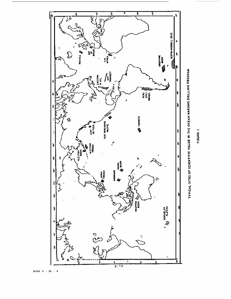
more than one major ocean. Typical sites are shown in Figure 1.
The main conclusions of these studies are that development and use of a
deepwater riser are technically feasible, and that the work should be accom-
plished from a large single hull drilling ship of the order of a little less
than 600 feet length.
Recently, added to these inputs as a special technical solution, was the
feasibility of converting the GLOMAR EXPLORER from a heavy lift vessel to an
oceanographic research drilling vessel, having capability to drill and core
the deep ocean basins and margins. The resulting study was extensive, but did
not address in depth the necessity to define certain parameters which could
affect final design of the system or components. Certain selected systems
and components should be subjected to predesign analysis and, where applicable,
B-17
>
L - a - y - - ..——— —9 b b b b
.
D — , U
63-314 0 - 80 - 8
selected development testing should be accomplished, prior to final system
design.
These various engineering studies, and the general conclusions derivedin each study, are summarized in the following subsections of this paper.
THE OCEAN RESOURCES ENGINEERING, INC. REPORT
In December 1974, Scripps Institution of Oceanography authorized
Ocean Resources Engineering, Inc. to study the technical and economic feasi-
bility of accomplishing the program objectives with conventional exploratory
drilling equipment. The scope of the study included:
(a) Determination of the minimum drilling vessel
requirements for this program.
(b) Evaluation of oceanographic conditions at
several geographical locations.
(c) Comparison of existing or planned drilling
vessels to determine what type of rig is
best suited for the Ocean Margins Program.
(d) Evaluation of existing marine riser equip-
ment and concepts.
(e] Determination of areas which need development,
improvement or extension of existing technology.
(f) Definition of special requirements for logistic
support.
The executive summary of the O.R.E. report, “Oceanographic and
Vessel Evaluation for IPOD Ocean Margins Study”, issued on 26 September 1975,
is quoted in part below:
"It is technically and economically feasible to extend the State-Of-
the-art technology utilized in conventional exploration drilling operations
in order to satisfy these special requirements of the Ocean Margins Program.
This program can be accomplished most effectively with a large, dynamically
positioned drillship which has an overall length of about 570 feet, a beam
of 85 feet and a maximum draft of 24 feet. This unit has the maneuverability
needed for widely dispersed drilling areas and has sufficient capacity for
storage of riser, drill pipe and drilling expendable. This unit is more
suitable and less expensive for the Ocean Margins Program than a semisubmersible
or small drillship.
B-19
"The most critical item which requires analysis, design, and testing
is the marine riser. Existing technology can be extended to meet these
needs by commencing a long-range engineering effort in the Fall of 1975.
For optimum performance, the drillship should be specially designed with
components sized and located as appropriate for these specific operations.
This vessel would have the inherent ability to conduct future exploratory
oil and gas drilling in deep water. Design and construction of the drillship
should commence in February 1977, with mobilization of the vessel accomplished
by May 1981. The scientific drilling program can be accomplished in about
4.3 years.
"The Ocean Margins Program may be funded either as a contractor owned,
contractor operated program or a government owned, contractor operated pro-
gram. . . . . The total program costs with the contractor owned equipment are
$283 million, while the total costs with the government owned equipment will
be only $227 million. Since significant savings can be effected, it is
strongly recommended that the drillship be government owned and operated by
an experienced offshore drilling contractor."
THE GLOBAL MARINE DEVELOPMENT, INC. REPORT
When the GLOMAR EXPLORER became available as a government owned vessel,
the Scripps Institution of Oceanography commissioned Global Marine Development,
Inc. to study the feasibility of converting this ship from a heavy lift plat-
form to a drilling platform for use in the Ocean Margins Drilling Program.
The conclusions derived from this study were presented in a report ‘Conversion
of the GLOMAR EXPLORER into a Deep Water Drilling and Coring Vessel", 28 Feb-
ruary 1977. These are summarized below: .
The demonstrated deep ocean performance of the GLOMAR EXPLORER, coupled
with the present lack of an operational assignment for the vessel, make the
U. S. government-owned GLOMAR EXPLORER an ideal candidate for the proposed
program. GMDI feels especially confident in the feasibility of using this
vessel for the proposed program. This confidence stems from our role as
prime contractor for this ship from its conception through detailed engineer-
ing and construction, subsequent "at sea” operations and ultimate lay-up in
the U. S. Reserve Fleet.
The versatility and flexibility of this ship due to its inherent size
advantage over the GLOMAR CHALLENGER is graphically depicted in Figure 2.
B-20
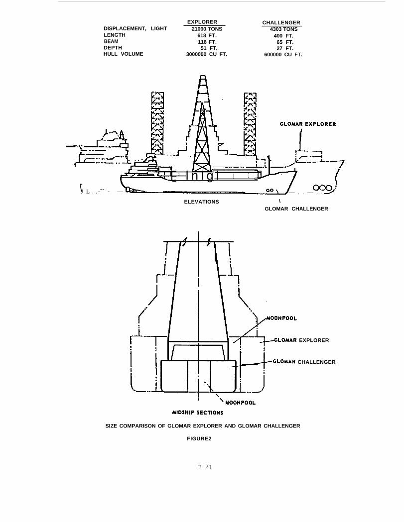
EXPLORERDISPLACEMENT, LIGHT 21000 TONSLENGTHBEAMDEPTHHULL VOLUME
CHALLENGER4303 TONS
618 FT. 400 FT.116 FT. 65 FT.51 FT. 27 FT.
3000000 CU FT. 600000 CU FT.
r\ --
L . . -
1 l n l g l I 1
J L . .- - — — . . — . .
ELEVATIONS \GLOMAR CHALLENGER
EXPLORER
CHALLENGER
SIZE COMPARISON OF GLOMAR EXPLORER AND GLOMAR CHALLENGER
FIGURE2
B-21
Significant conclusions from this study are:
o
0
0
0
0
0
0
0
The GLOMAR EXPLORER can, with minor modifications, main-
tain position for deep water drilling as well as, or
better than, existing "large" drilling ships.
The vessel motions are less than those of “large”
drilling ships operating under the same environmental
conditions.
The vessel has more than adequate stowage capacity for
the specified operation. At sea resupply should not
be necessary for legs less than 150 days except for
crew change.
Weather downtime at the specified operating sites, is
expected to be less than two percent assuming opera-
tion does not take place during the favorable seasons
at the specified sites.
The large vessel size allows all specified laboratory
and scientific accommodations to be incorporated ‘
either in permanent spaces or temporary vans. There
is additional capacity available to increase these
facilities if desired.
The unique heave compensated gimbal system allows
support and tensioning of the riser such that the
riser will not require any type of flotation. This
capability obviously simplifies the riser itself as
well as all associated handling and support equipment.
Handling of the drill pipe sections from the storage
area to the moving gimballed rig floor at acceptable
rates can be accomplished.
The vessel is already in the U. S. Government inventory.
Therefore, the cost of operating the vessel, on a day
rate basis, is comparable to other contractor-owned
"large” drilling ships.
B-22
THE DONHAISER MARINE, INC. REPORTS
The National Science Foundation contracted with Donhaiser Marine, Inc.
(DMI) to conduct a comparative review of the O. R. E. report and the GMDI
report as well as to draw conclusions from these and other input information
regarding the engineering approach that should be taken by the Foundation
and to estimate the costs that would be incurred in the engineering aspects
of the program. DMI presented its conclusions in three reports issued from
July 1978 to November 1978.The conclusions of these reports are summarized
in abbreviated form below:
o The most cost effective method of carrying out the Ocean Margins
Drilling Program will be for the government to own a suitable drilling
vessel, riser and well control system, drill pipe and related equip-
ment and contract for its operation. The total difference in cost
over a five year program utilizing the modified GLOMAR EXPLORER, con-
tractor operated as compared to contracting for a contractor owned
new drillship will be in the order of magnitude of 160 millon dollars
based on 1978 dollars with an 8% per year escalation.
o The GLOMAR EXPLORER, with suitable modifications, appears to be a
feasible and financially attractive Ocean Margin Drilling vessel.
o Due to the large size (over twice the displacement of present
large drillships) the GLOMAR EXPLORER will have relatively low
motion response characteristics which should result in a low
percentage of operation downtime due to weather in most geographic
areas of the world.
o The vessel has ample storage capacity for the anticipated opera-
tion. With modification, the vessel will have a capacity for carry-
ing expendable in excess of that required for carrying out the
proposed program missions.
o All of the initially specified laboratories and scientific
accommodations can be incorporated in the vessel with ample additional
capacity for expansion of these facilities if desired.
o The vessel can be readily modified to incorporate conventional
systems for storage, handling and deploying the necessary riser,
B-23
casing and drill pipe required for the proposed Ocean Margins
Drilling Program.
o The vessel has ample installed generating capacity to pro-
vide the necessary power requirements for drilling and station-
keeping. However, initial studies indicate marginal or possibly
inadequate stationkeeping performance during the passage of
weather fronts, squall lines, and thunderstorms due to limita-
tions of present thrusters and main propellers but modifications
can be made to thrusters and main propellers to provide ample
thrust to maintain station for the short-term severe environmental
conditions.
o The vessel’s transit speed which is approximately 12 knotsis sufficient for carrying out a world-wide scientific coring
program.
o Generally, due to the GLOMAR EXPLORER’S size, present arrange-.
ment, elaborate equipment and recent construction, we see no
reason why this vessel cannot be modified to provide one of the
finest dynamically positioned drillships afloat today. AIso,
due to the fact that structural, piping and electrical modifi-
cations necessary for installation of required drilling and
riser handling equipment will not be of a major nature, it
should be possible to convert the GLOMAR EXPLORER to a modern,
high capacity, drilling and coring vessel for a small fraction
of the cost of building a new drillship of comparable size and
capacity.
o Both the ORE buoyed riser concept and the GMDI non-buoyed riser
concept appear to be technically feasible; i.e., no insurmountable
technical problems have been identified to date. However, both
concepts would require additional design studies to arrive at an
optimized design and fully identify and correct potential problems.
The DMI preferred riser design concept is the buoyed riser.
B-24
— —
NATIONAL RESEARCH COUNCIL/MARINE BOARD REPORT
In the Spring of 1978, the National Science Foundation requested the
Marine Board-Assembly of Engineering of the National Research Council/National
Academy of Sciences to conduct an in-depth review of the background, scope,
and proposed plans for drilling into the deep reaches of the ocean for scien-
tific purposes. Although the review was to be oriented primarily to the
engineering aspects of the problem, the committee formed to conduct the
review comprised individuals with expertise in ocean geology, seismology,marine engineering, offshore resource recovery, ship design and navigation,
and political, environmental, and management matters.
Specifically, the committee was charged by NSF to:
o
0
0
0
0
0
Relate the technology for drilling and obtaining core samples
in the deep ocean to the objectives of the proposed scientific
program, (e.g., depth, penetration, environmental forces) with
particular emphasis on the technical feasibility, capability
and prospects of overcoming deficiencies.
Consider alternatives to drilling to achieve the program’s
objectives.
Examine particularly the riser and well control systems, and
related technology including the probable environmental
effects of system failure, and costs of these systems.
Assess the options and costs of alternative drilling platforms.
Compare the costs of various methods by which the program’s
objectives could be met.
Assess the relationships between the Federal government and
the drilling industry, as well as among government agencies,
as they relate to deep sea drilling.
Over the course of its review, the committee analyzed all of the scien-
tific reports listed in the previous section and all of the engineering reports
described above. An interim report was issued in November 1978 and the final
report “Engineering for Deep Sea Drilling for Scientific Purposes” was delivered
to NSF in April 1980. The recommendations contained therein are quoted below:
"The committee developed several specific recommendations for NSF action
in its proposed continuation of deep sea drilling for scientific purposes.
These recommendations are generally couched in terms of the use of EXPLORER
and the goals of penetrating 20,000 feet of sediments at water depths of
13,000 feet. Despite this, the committee considers essentially all of the
recommendations to be equally pertinent to other possible platforms and
drilling-penetration or water depth goals. In essence, the committee rec-
comends that:
o
0
0
0
0
0
0
NSF establish a strong management team to control and
guide the program and to maintain close industry contacts
to ensure that the required technology is developed.
The program be operated and the equipment be developed
using a systems-engineering approach as outlined in this
report and its Appendix B.
Adequate time and funds be allocated for a thorough pre-
liminary engineering study of at least two years duration
prior to converting the ship or fabricating any major
equipment.
In the drilling-system design, early attention be given to
the major critical design issues--well control, riser
handling, casing programs --enumerated in the body of the
report.
The budget be reviewed and modified to include the cost of
additional equipment, data gathering, acquiring and train-
ing a crew, and geophysical
more realistic estimates of
Increased effort be devoted
for engineering design use,
surveys, and to account for
inflation.
to collecting and analyzing,
as much meteorological,
oceanographic, and ocean-floor geotechnical data as
possible in the broad geographic areas of concern to the
program. Further, this effort should be extended as early
as possible to acquiring similar data for specific smaller
areas as the site-selection process narrows down the areas
under consideration.
Undertake adaptation of existing and development of new
logging and downhole measurement equipment to improve the--oo—__e -..–
B-26
—
0
0
safety of drilling operations and to lessen the scientific
impact of the anticipated reduction in core recovery from
deep-penetration holes.
Include funding for improved coring equipment and techni-
ques for sedimentary and igneous rocks in the initial
system design and development effort.
Early attention be given to personnel recruitment and train-
ing, so that key operational personnel can help design and
develop both equipment and procedures. This includes the
concurrent development of computer-based drilling simulators
for initial use as design aids and training tools and later
use for problem-solving and continued training.”
NATIONAL SCIENCE FOUNDATION MANAGEMENTOF THE OCEAN MARGINS DRILLING PROGRAM
As the government manager of the Deep Sea Drilling Project, the National
Science Foundation encouraged, participated in, and funded the intial scientific
and engineering studies that resulted in the FUSOD report, the O. R. E. report
and the GMDI report. Similarly, the DSDP management, in response to the
recommendations of these reports, convened the Ad-Hoc Group for Future
Scientific Drilling and contracted with Donhaiser Marine, Inc. to review the
scientific and engineering aspects of the program. Additionally, with support
from ONR and USGS, the National Academy of Sciences Ocean Ociences Board was
requested to review the scientific program and the Marine Board was requested
to review the engineering program.
DEVELOPMENT OF A MANAGEMENT STRUCTURE
The input that NSF received from all of these committees and advisory
groups not only helped to formulate the scientific” and engineering programs
but also provided suggestions as to the level of funding required and as to
how the OMD program should be managed. Finally, the Blue Ribbon Committee
report strongly supported the program and also recommended that it be funded
with add-on or new money in the NSF budget and that it be given high priority;
foreign participation was also encouraged.
B-27
A final impetus was given to the program when President Carter, at
the urging of his science advisor Dr. Frank press, invited members of the
oil industry to participate in the project on a cost sharing basis with
the government. Subsequent negotiations resulted in the agreement by
a number of oil companies to share 50% of the total program costs for
the initial phases with the option to continue for the total program.
Thus, if the oil companies remain satisfied with the program plans and
progress, the cost to the government will be only half what it otherwise
might have been.
As a result of the inputs from the scientific and engineering studies,
the recommendations of the Blue Ribbon Committee, and the prospect of shar-
ing the cost of the program with the oil industry, a revised management
structure was established within the NSF to adapt prior management concepts
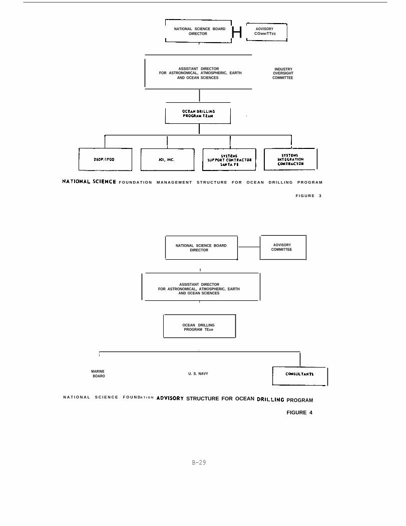
to existing programs and to the Ocean Margins Drilling Program. This
structure is delineated in Figure 3. It should be noted that the Advisory
Committee to the Director and the Industry Oversight Committee, the latter
comprising oil company representatives, are in the process of being estab-
lished. Using funds from the current budget, the Systems Support Contractor,
Santa Fe Engineering Service Company, is presently under contract to NSF;
the Systems Integration Contractor, who will be responsible for system
design, construction, and operation, will be selected after the program
has been specified in sufficient detail to prepare formal invitations to
bid. Scripps is presently under contract for the continuing DSDP/IPOD
project and JOI, Inc. is also formally participating in the project on a
contractual basis.
In addition to the basic program management by NSF, there are being
established groups of advisors who will advise both the Director and the
Ocean Program Drilling Team. The structure of these advisory bodies is
shown in Figure 4. The OMD Advisory Committee will be made up of 40%
industry representatives, 40% from academia, and 20% from the public sector.
The Marine Board of the National Research Council has already selected a
smaller advisory group from among those who served on the 1978-1979 Commit-
tee. The Navy is to be called upon for its expertise in ship conversion
inspection and supervision. Additional consultants from government and
industry will be called upon as required for assisting in various facets of
B-28
NATIONAL SCIENCE BOARD H AOVISORYOIRECTOR COMMITTEE I
ASSISTANT DIRECTOR INDUSTRYFOR ASTRONOMICAL, ATMOSPHERIC, EARTH OVERSIGHT
AND OCEAN SCIENCES COMMITTEE
F O U N D A T I O N M A N A G E M E N T S T R U C T U R E F O R O C E A N D R I L L I N G P R O G R A M
F I G U R E 3
MARINEBOARO
N A T I O N A L S C I E N C E F O U N DA T I O N
NATIONAL SCIENCE BOARD AOVISORYDIRECTOR COMMITTEE
●
I
.
ASSISTANT DIRECTORFOR ASTRONOMICAL, ATMOSPHERIC, EARTH
AND OCEAN SCIENCES
I
OCEAN DRILLINGPROGRAM TEAM
U. S. NAVY
I1
STRUCTURE FOR OCEAN PROGRAM
FIGURE 4
B-29
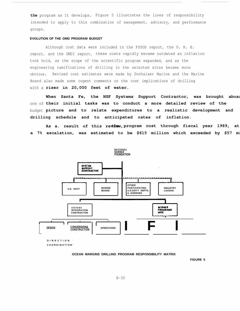
the program as it develops. Figure 5 illustrates the lines of responsibility
intended to apply to this combination of management, advisory, and performance
groups.
EVOLUTION OF THE OMD PROGRAM BUDGET
Although cost data were included in the FUSOD report, the O. R. E.
report, and the GMDI report, these costs rapidly became outdated as inflation
took hold, as the scope of the scientific program expanded, and as the
engineering ramifications of drilling in the selected sites became more
obvious. Revised cost estimates were made by Donhaiser Marine and the Marine
Board also made some cogent comments on the cost implications of drilling
with a
one of
budget
riser in 20,000 feet of water.
When Santa Fe, the NSF Systems Support Contractor, was brought aboar
their initial tasks was to conduct a more detailed review of the
picture and to relate expenditures to a realistic development and
drilling schedule and to anticipated rates of inflation.
As a. result of this review,the program cost through fiscal year 1989, at
a 7% escalation, was estimated to be $615 million which exceeded by $57 mi
NATIONALSCIENCEFOUNDATION
OTHER
U.S. NAVY MARINE PARTICIPATING INDUSTRYBOARD U.S.GOV’T DEPTS. LIAISON
& AGENCIES
SYSTEMSINTEGRATIONCONTRACTOR
● .
1
I DESIGN CONVERSION&CONSTRUCTION
~
D I R E C T I O N —
C O O R D I N A T l O N ----
OPERATlONS I F l
OCEAN MARGINS DRILLING PROGRAM RESPONSIBILITY MATRIX
FIGURE 5
B-30
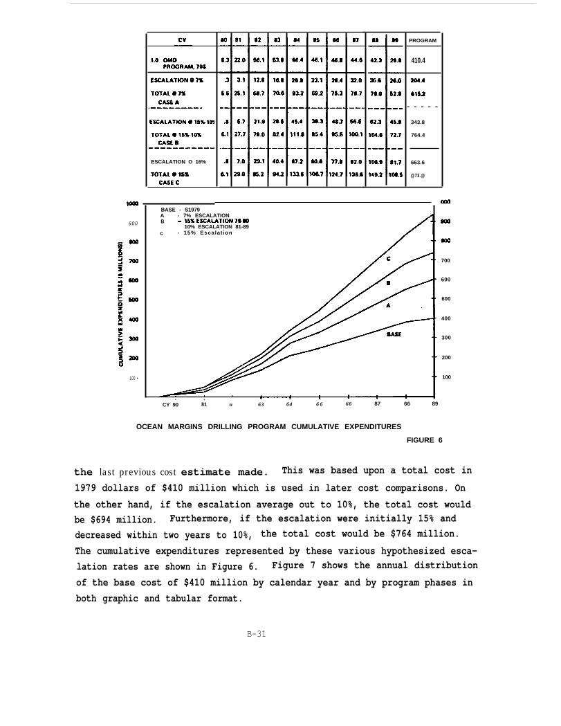
ESCALATION O 16%
PROGRAM
410.4
- - - - -
343.8
764.4
663.6
@73.@
600
100 +
BASE - S1979A - 7% ESCALATIONB
10% ESCALATION 81-89c - 15% Escalat ion
700
600
600
400
300
200
100
. ,CY 90 81 u 63 64 6 6 66 87 66 89
OCEAN MARGINS DRILLING PROGRAM CUMULATIVE EXPENDITURES
FIGURE 6
the last previous cost estimate made. This was based upon a total cost in
1979 dollars of $410 million which is used in later cost comparisons. On
the other hand, if the escalation average out to 10%, the total cost would
be $694 million. Furthermore, if the escalation were initially 15% and
decreased within two years to 10%, the total cost would be $764 million.
The cumulative expenditures represented by these various hypothesized esca-
lation rates are shown in Figure 6. Figure 7 shows the annual distribution
of the base cost of $410 million by calendar year and by program phases in
both graphic and tabular format.
B-31

8a
70
60
$ MILLIONS
m
40
30
20
10
LEGEND
SCIENCE OPS & MGMTSCIENCE PROGRAM
SHIP OPERATIONS
CONSTRUCTION6
DESIGN
4
6 6
4 4
3 3
3
2
4
2 11
2
82 84 85 88 87 86 .88CY 80 81
——60—
4.2
.6
.5
—53
—
86
30.7
11.6
TOTAL83 84 85
31.8
14.3
86
31.8
150
4.2
83.7
210.8
111.7
1.1 PROGRAMSUPPORT. 79S
1.2 EXPLORERCONVERSION. 79S
1.3 DRILLINGOPERATIONS. 70S
14 SCIENTlFlCPROGRAMS. 79S
1.0 OMDPROGRAM. 79s
9.2
1.2
11.6
148
25.8
13.2
22.5
30.3
13.6
20.7
6.1
53.8 66.4 46.1 46.8 44.6 42.3 26.8 410.422.0
GRAPHIC AND TABULAR DISTRIBUTION OF PLANNED EXPENDITURES
FIGURE 7
Currently, the total program funding figure being used for discussion
is $700 million of which $350 million will be supplied by the government and
$350 million by industry. Although the curves of Figures 6 and 7 show these
expenditures being made over calendar years 1980 through 1989, it is antici-
pated that the program will move somewhat more slowly at the beginning with
a consequent stretch-out to calendar year 1990.
B-32