Embed Size (px)
Citation preview
1|
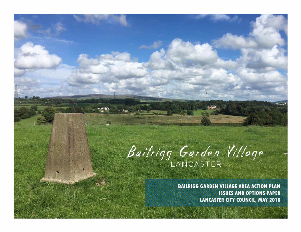
BAILRIGG GARDEN VILLAGE AREA ACTION PLAN
ISSUES AND OPTIONS PAPER
LANCASTER CITY COUNCIL, MAY 2018
Bailrigg Garden Village and South Lancaster Growth Spatial Framework for Development
The Bailrigg Garden Village Area Action Plan
Issues and Options Paper
Lancaster City Council, May 2018
LCC LOGO
All maps contained in this document are reproduced from Ordnance Survey mapping with the permission of the Controller of Her Majesty’s Office © Crown Copyright. Unauthorised reproduction infringes Crown Copyright and may lead to civil proceedings. Lancaster City Council Licence No. LA 1000025403.
We are not responsible for the content of external sites. All links correct at the point of publication.
3|
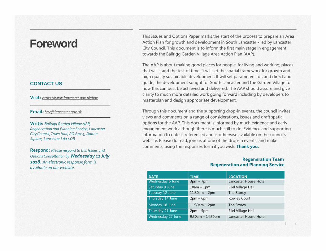
Foreword This Issues and Options Paper marks the start of the process to prepare an Area
Action Plan for growth and development in South Lancaster - led by Lancaster
City Council. This document is to inform the first main stage in engagement
towards the Bailrigg Garden Village Area Action Plan (AAP).
The AAP is about making good places for people, for living and working; places
that will stand the test of time. It will set the spatial framework for growth and
high quality sustainable development. It will set parameters for, and direct and
guide, the development sought for South Lancaster and the Garden Village for
how this can best be achieved and delivered. The AAP should assure and give
clarity to much more detailed work going forward including by developers to
masterplan and design appropriate development.
Through this document and the supporting drop-in events, the council invites
views and comments on a range of considerations, issues and draft spatial
options for the AAP. This document is informed by much evidence and early
engagement work although there is much still to do. Evidence and supporting
information to date is referenced and is otherwise available on the council’s
website. Please do read, join us at one of the drop-in events, and make
comments, using the responses form if you wish. Thank you.
CONTACT US
Visit: https://www.lancaster.gov.uk/bgv
Email: [email protected]
Write: Bailrigg Garden Village AAP,
Regeneration and Planning Service, Lancaster
City Council, Town Hall, PO Box 4, Dalton
Square, Lancaster LA1 1QR
Respond: Please respond to this Issues and
Options Consultation by Wednesday 11 July
2018. An electronic response form is
available on our website.
DATE TIME LOCATIONWednesday 6 June 3pm – 7pm Lancaster House Hotel
Saturday 9 June 10am – 1pm Ellel Village Hall
Tuesday 12 June 11:30am – 2pm The Storey
Thursday 14 June 2pm – 6pm Rowley Court
Monday 18 June 11:30am – 2pm The Storey
Thursday 21 June 2pm – 5pm Ellel Village Hall
Wednesday 27 June 9:30am – 14:30pm Lancaster House Hotel
Regeneration TeamRegeneration and Planning Service
4|
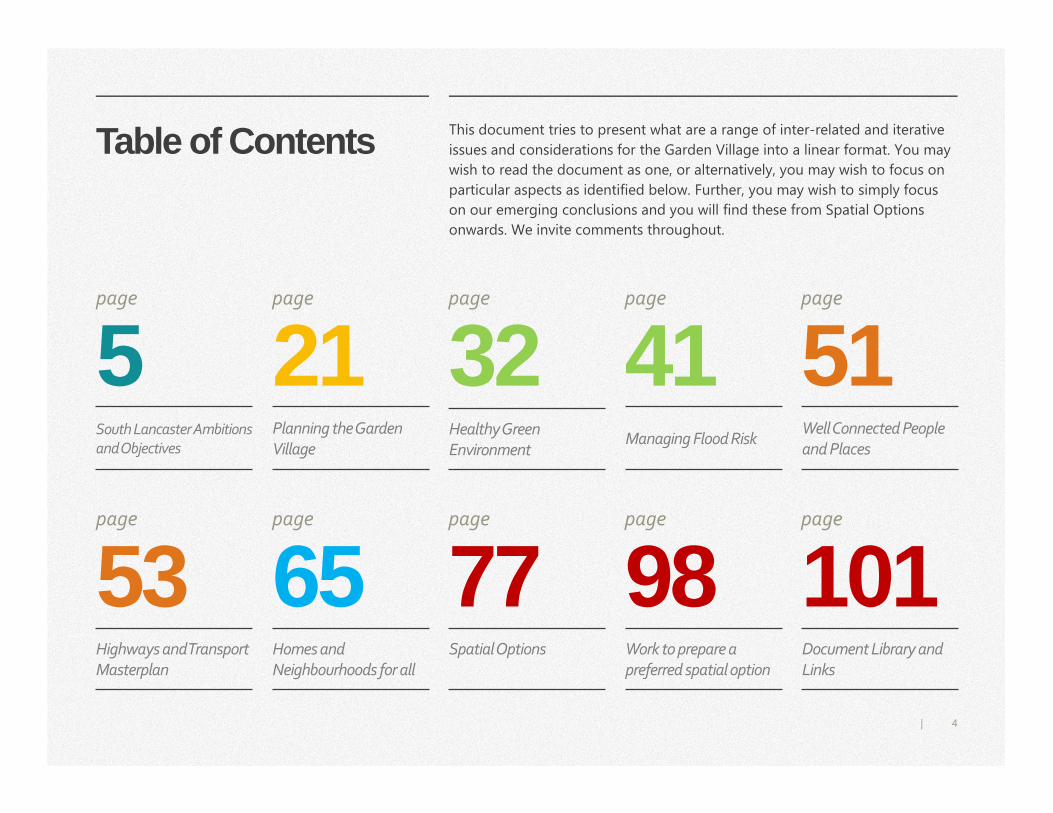
Table of Contents
5
This document tries to present what are a range of inter-related and iterative
issues and considerations for the Garden Village into a linear format. You may
wish to read the document as one, or alternatively, you may wish to focus on
particular aspects as identified below. Further, you may wish to simply focus
on our emerging conclusions and you will find these from Spatial Options
onwards. We invite comments throughout.
21 32 41 51page page page page page
53 65 77 98 101page page page page page
South Lancaster Ambitions
and Objectives
Planning the Garden
Village Healthy Green
Environment Managing Flood Risk
Well Connected People
and Places
Highways and Transport
Masterplan
Homes and
Neighbourhoods for all
Spatial Options Work to prepare a
preferred spatial option
Document Library and
Links
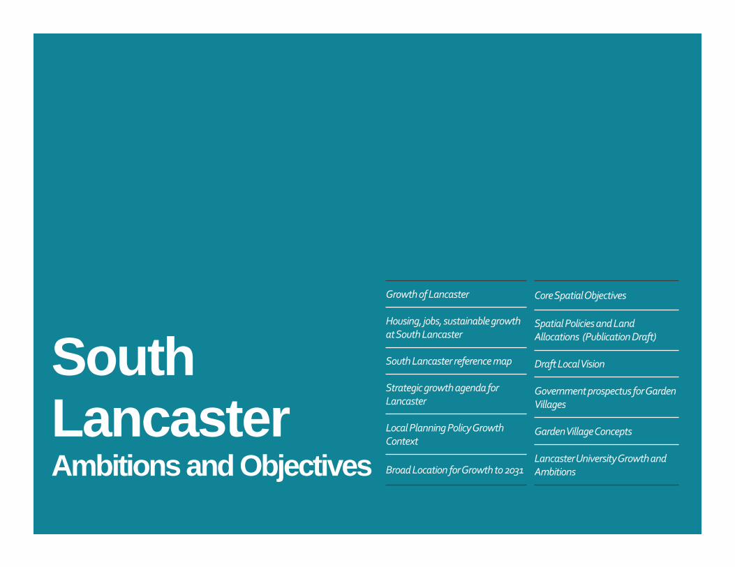
South Lancaster Ambitions and Objectives
Growth of Lancaster
Housing, jobs, sustainable growth
at South Lancaster
South Lancaster reference map
Strategic growth agenda for
Lancaster
Local Planning Policy Growth
Context
Broad Location for Growth to 2031
Core Spatial Objectives
Spatial Policies and Land
Allocations (Publication Draft)
Draft Local Vision
Government prospectus for Garden
Villages
Garden Village Concepts
Lancaster University Growth and
Ambitions
6|
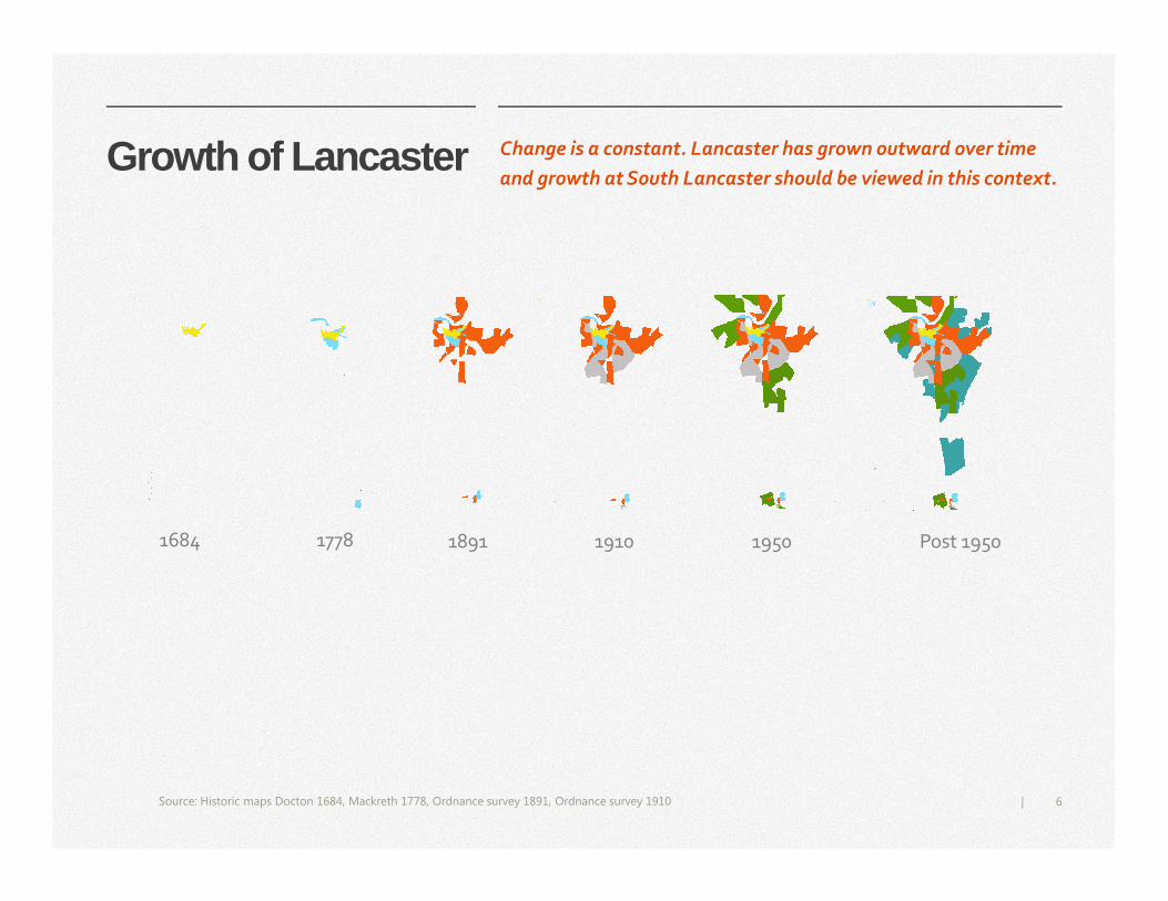
Growth of Lancaster
Source: Historic maps Docton 1684, Mackreth 1778, Ordnance survey 1891, Ordnance survey 1910
Change is a constant. Lancaster has grown outward over time
and growth at South Lancaster should be viewed in this context.
Post 1950 19501910189117781684
7|
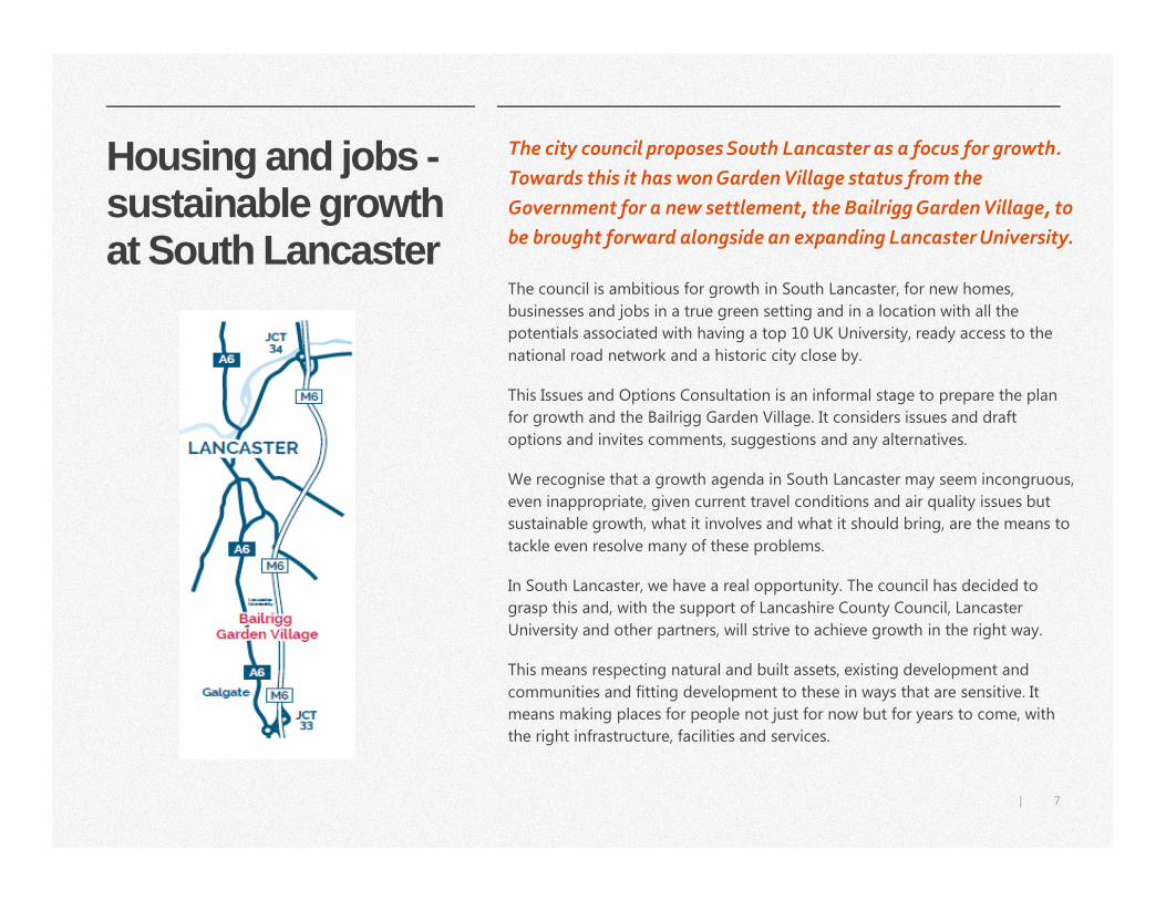
Housing and jobs -sustainable growth at South Lancaster
The city council proposes South Lancaster as a focus for growth.
Towards this it has won Garden Village status from the
Government for a new settlement, the Bailrigg Garden Village, to
be brought forward alongside an expanding Lancaster University.
The council is ambitious for growth in South Lancaster, for new homes,
businesses and jobs in a true green setting and in a location with all the
potentials associated with having a top 10 UK University, ready access to the
national road network and a historic city close by.
This Issues and Options Consultation is an informal stage to prepare the plan
for growth and the Bailrigg Garden Village. It considers issues and draft
options and invites comments, suggestions and any alternatives.
We recognise that a growth agenda in South Lancaster may seem incongruous,
even inappropriate, given current travel conditions and air quality issues but
sustainable growth, what it involves and what it should bring, are the means to
tackle even resolve many of these problems.
In South Lancaster, we have a real opportunity. The council has decided to
grasp this and, with the support of Lancashire County Council, Lancaster
University and other partners, will strive to achieve growth in the right way.
This means respecting natural and built assets, existing development and
communities and fitting development to these in ways that are sensitive. It
means making places for people not just for now but for years to come, with
the right infrastructure, facilities and services.
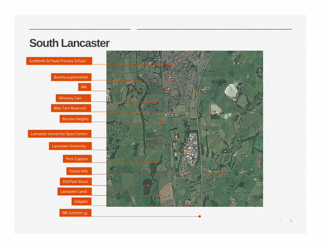
8|
Lancaster Canal
M6
Burrow Heights
Lancaster University Sport Centre
Lancaster University
Park Coppice
Forest Hills
Galgate
Booths supermarket
Scotforth St Pauls Primary School
Blea Tarn Reservoir
South Lancaster
M6 Junction 33
Old Park Wood
Whinney Carr
9|
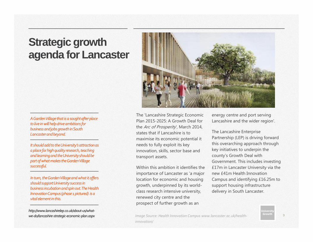
Strategic growth agenda for Lancaster
The ‘Lancashire Strategic Economic
Plan 2015-2025: A Growth Deal for
the Arc of Prosperity’, March 2014,
states that if Lancashire is to
maximise its economic potential it
needs to fully exploit its key
innovation, skills, sector base and
transport assets.
Within this ambition it identifies the
importance of Lancaster as ‘a major
location for economic and housing
growth, underpinned by its world-
class research intensive university,
renewed city centre and the
prospect of further growth as an
energy centre and port serving
Lancashire and the wider region’.
The Lancashire Enterprise
Partnership (LEP) is driving forward
this overarching approach through
key initiatives to underpin the
county’s Growth Deal with
Government. This includes investing
£17m in Lancaster University via the
new £41m Health Innovation
Campus and identifying £16.25m to
support housing infrastructure
delivery in South Lancaster.
A Garden Village that is a sought after place to live in will help drive ambitions for business and jobs growth in South Lancaster and beyond.
It should add to the University’s attraction as a place for high quality research, teaching and learning and the University should be part of what makes the Garden Village successful.
In turn, the Garden Village and what it offers should support University success in business incubation and spin out. The Health Innovation Campus (phase 1 pictured) is a vital element in this.
University Growth
University Growth Image Source: Health Innovation Campus www.lancaster.ac.uk/health-
innovation/
http://www.lancashirelep.co.uk/about-us/what-
we-do/lancashire-strategic-economic-plan.aspx
10|
Local Planning Policy Growth Context
These policies target some 3,500
homes for the Garden Village with
1,655 delivered by 2031 (Lancaster
Local Plan period) and, some 2,000
new jobs across the area. The
policies establish the overarching
core principles for the Garden
Village.
What these policies do not do is
determine the shape of the Garden
Village. The Council will do this
through an Area Action Plan.
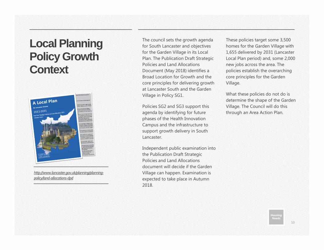
http://www.lancaster.gov.uk/planning/planning-
policy/land-allocations-dpd
The council sets the growth agenda
for South Lancaster and objectives
for the Garden Village in its Local
Plan. The Publication Draft Strategic
Policies and Land Allocations
Document (May 2018) identifies a
Broad Location for Growth and the
core principles for delivering growth
at Lancaster South and the Garden
Village in Policy SG1.
Policies SG2 and SG3 support this
agenda by identifying for future
phases of the Health Innovation
Campus and the infrastructure to
support growth delivery in South
Lancaster.
Independent public examination into
the Publication Draft Strategic
Policies and Land Allocations
document will decide if the Garden
Village can happen. Examination is
expected to take place in Autumn
2018.
Housing Needs
Housing Needs
11|
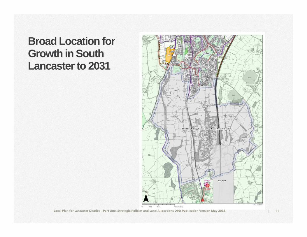
Broad Location for Growth in South Lancaster to 2031
Local Plan for Lancaster District – Part One: Strategic Policies and Land Allocations DPD Publication Version May 2018
12|
Core Spatial Objectives for the Garden Village
If the mandate for growth is established as discussed, how growth is framed
for and within the Garden Village is for the Area Action Plan. We propose:
• A Garden Village with a distinct sense of place
• Clear separation between the Garden Village and existing settlements
• Network of green corridors
• High quality open space
• Local landscape and heritage assets conserved
• Good local accessibility by walking and cycling
• Ready access by sustainable transport (buses and cycling) to/from the city centre
• Wide range of jobs within a ready travel distance
• Scope for campus growth
• Resilience to climate change
• Effective drainage and flood risk to communities downstream mitigated
• No harm to designated wildlife sites
• Net biodiversity gains
• Facilities and services to meet needs in a strong local centre
• Village centre complementary to the public offer on campus
• Sociable neighbourhoods
• Housing to meet needs
• Low carbon development
• Good digital connectivity
If it is determined that the Garden
Village can happen, the details will be
shaped through an Area Action Plan.
Area Action Plans (AAPs) are a type of
development plan document that
provide a planning framework for a
specific area of opportunity, change or
conservation.
AAPs give a specific geographic focus for
policy and the actions required by many
partners to deliver beneficial change.
Further information about the planning
process can be found in the ‘Planning
the Garden Village’ chapter.
Core Spatial Objectives
These draw variously from –
• The key principles for development set in the Publication Draft Policy SG1 (see page 13)
• The draft local vision for the Garden Village (pg. 14-15)
• The Government prospectus for garden villages (pg. 16)
• The Town and Country Planning Association’s advised key principles for planning a Garden Village (pg. 17)
• Lancaster University Masterplan 2017-2027 (pg. 18-19).
13|
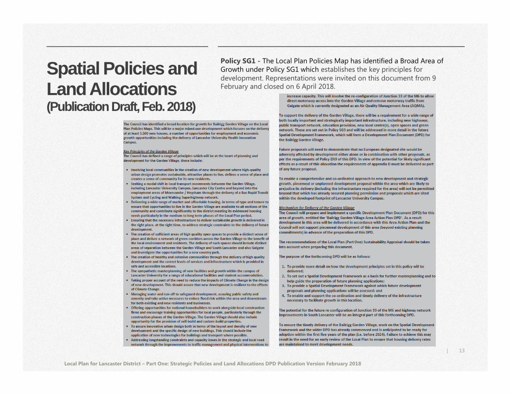
Spatial Policies andLand Allocations(Publication Draft, Feb. 2018)
Local Plan for Lancaster District – Part One: Strategic Policies and Land Allocations DPD Publication Version February 2018
Policy SG1 - The Local Plan Policies Map has identified a Broad Area of Growth under Policy SG1 which establishes the key principles for development. Representations were invited on this document from 9 February and closed on 6 April 2018.
14|
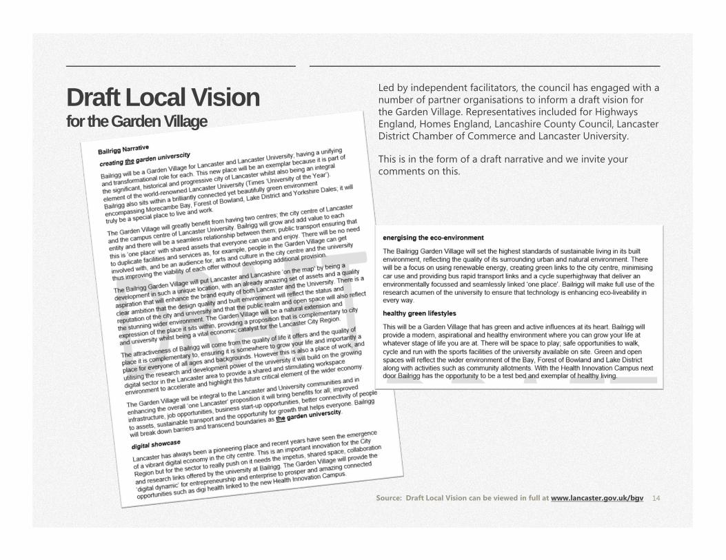
Draft Local Visionfor the Garden Village
Led by independent facilitators, the council has engaged with a number of partner organisations to inform a draft vision for the Garden Village. Representatives included for Highways England, Homes England, Lancashire County Council, Lancaster District Chamber of Commerce and Lancaster University.
This is in the form of a draft narrative and we invite your comments on this.
Source: Draft Local Vision can be viewed in full at www.lancaster.gov.uk/bgv
15|
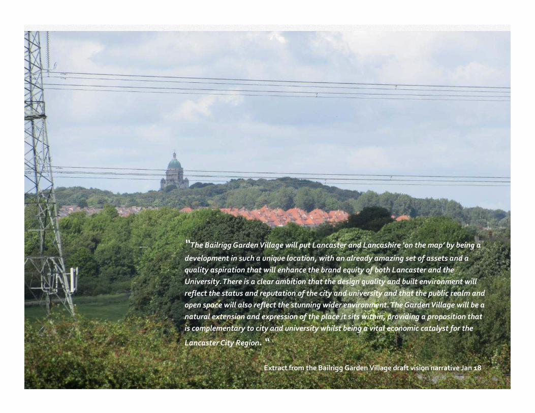
“The Bailrigg Garden Village will put Lancaster and Lancashire ‘on the map’ by being a
development in such a unique location, with an already amazing set of assets and a
quality aspiration that will enhance the brand equity of both Lancaster and the
University. There is a clear ambition that the design quality and built environment will
reflect the status and reputation of the city and university and that the public realm and
open space will also reflect the stunning wider environment. The Garden Village will be a
natural extension and expression of the place it sits within, providing a proposition that
is complementary to city and university whilst being a vital economic catalyst for the
Lancaster City Region. “
Extract from the Bailrigg Garden Village draft vision narrative Jan 18
16|
Government Prospectus for Garden Villages
The Council accepted the city council’s bid for Garden Village status for Bailrigg
in January 2017.
The Government makes clear through their ‘Locally-led Garden Villages, Towns
and Cities’ Prospectus, (Department for Communities and Local Government,
March 2016), that there is no single template for garden villages. It does
however set some broad definitions for Garden Villages:
� New settlements to be between 1,500 and 10,000 new homes.
� Free-standing development
� Local authority led
The prospectus further establishes that Garden Villages should offer:
• A clear and distinct sense of identity
• Innovative approaches and solutions
• Embedded garden city principles to raise the bar
• Attractive, well designed places with public support.
We shall work with key partner Homes England (formerly the Homes and
Communities Agency) and others to achieve this.
https://www.gov.uk/government/publications/
locally-led-garden-villages-towns-and-cities
17|
Garden Village Concepts Ebenezer Howard published the book ‘Tomorrow: a
Peaceful Path to Real Reform’ (1898) out of his
concerns about social issues. This proposed the
creation of new towns of limited size, planned in
advance and surrounded by a belt of agricultural
land. The publication resulted in the founding of the
garden city movement. The Garden City concept was
an effective response for a better quality of life in
over crowded and dirty industrial towns.
Everything has changed since Ebenezer Howard’s
original Garden City Concept. We now live in the age
of mass car ownership, ever changing technology,
easier access to multiple sources of renewable and
non renewable energy. The Town and Country
Planning Association have therefore distilled
Ebenezer Howard’s original Garden City principles
and articulated them for a 21st century context.
Although the following issues are aimed at a city,
they are still relevant for a 21st century garden
village and be considered as the main key issues to
consider when planning the Bailrigg Garden Village.
A Garden City is a holistically planned new settlement which enhances the
natural environment and offers high-quality affordable housing and locally
accessible work in beautiful, healthy and sociable communities. The Garden
City principles are an indivisible and interlocking framework for their delivery,
and include:
• Land value capture for the benefit of the community.
• Strong vision, leadership and community engagement.
• Community ownership of land and long-term stewardship of assets.
• Mixed-tenure homes and housing types that are genuinely affordable.
• A wide range of local jobs in the Garden City within easy commuting distance of homes.
• Beautifully and imaginatively designed homes with gardens, combining the best of town and country to create healthy communities, and including opportunities to grow food.
• Development that enhances the natural environment, providing a comprehensive green infrastructure network and net biodiversity gains, and that uses zero-carbon and energy-positive technology to ensure climate resilience.
• Strong cultural, recreational and shopping facilities in walkable, vibrant, sociable neighbourhoods.
• Integrated and accessible transport systems, with walking, cycling and public transport designed to be the most attractive forms of local transport.
Town and Country Planning Association
https://www.tcpa.org.uk/garden-city-principles
18|
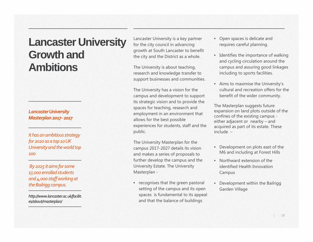
Lancaster University Growth and Ambitions
Lancaster University is a key partner
for the city council in advancing
growth at South Lancaster to benefit
the city and the District as a whole.
The University is about teaching,
research and knowledge transfer to
support businesses and communities.
The University has a vision for the
campus and development to support
its strategic vision and to provide the
spaces for teaching, research and
employment in an environment that
allows for the best possible
experiences for students, staff and the
public.
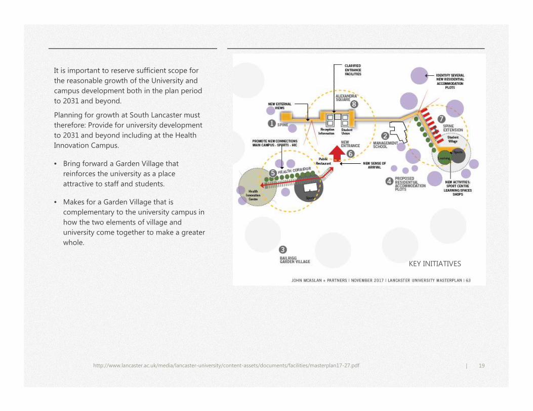
The University Masterplan for the
campus 2017-2027 details its vision
and makes a series of proposals to
further develop the campus and the
University Estate. The University
Masterplan -
• recognises that the green pastoral
setting of the campus and its open
spaces is fundamental to its appeal
and that the balance of buildings
• Open spaces is delicate and
requires careful planning.
• Identifies the importance of walking
and cycling circulation around the
campus and assuring good linkages
including to sports facilities.
• Aims to maximise the University’s
cultural and recreation offers for the
benefit of the wider community.
The Masterplan suggests future expansion on land plots outside of the confines of the existing campus -either adjacent or nearby – and acquired as part of its estate. These include –
• Development on plots east of the M6 and including at Forest Hills
• Northward extension of the
identified Health Innovation
Campus
• Development within the Bailrigg
Garden Village
Lancaster University
Masterplan 2017- 2027
It has an ambitious strategy
for 2020 as a top 10 UK
University and the world top
100
By 2025 it aims for some
17,000 enrolled students
and 4,000 staff working at
the Bailrigg campus.
http://www.lancaster.ac.uk/facilities/about/masterplan/
19|
http://www.lancaster.ac.uk/media/lancaster-university/content-assets/documents/facilities/masterplan17-27.pdf
KEY INITIATIVES
It is important to reserve sufficient scope for
the reasonable growth of the University and
campus development both in the plan period
to 2031 and beyond.
Planning for growth at South Lancaster must
therefore: Provide for university development
to 2031 and beyond including at the Health
Innovation Campus.
• Bring forward a Garden Village that
reinforces the university as a place
attractive to staff and students.
• Makes for a Garden Village that is
complementary to the university campus in
how the two elements of village and
university come together to make a greater
whole.
20|
South Lancaster Objectives and Ambitions
Do you agree with our proposed Core Spatial Objecti ves (pg. 12)? These are to shape how we plan the Garden Village and
growth in South Lancaster.
Q1
Do you agree with the draft vision for Bailrigg Gar den Village? (pg. 14-15).
Do you have any further comments or suggestions to make on this section?
Q2
Q3
Planning the Garden Village
Area Action Plan Timeline
Engagement and
Evidence to date
Planning History
Making the Village,
Infrastructure
Development and Funding
Spatial Framework for
Development
Towards Spatial Options
Spatial Framework –
preparing options
22|
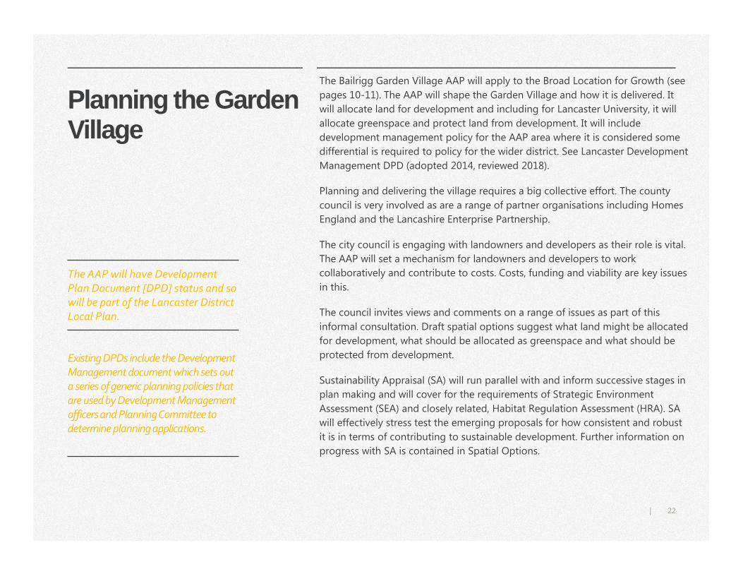
Planning the Garden Village
The Bailrigg Garden Village AAP will apply to the Broad Location for Growth (see
pages 10-11). The AAP will shape the Garden Village and how it is delivered. It
will allocate land for development and including for Lancaster University, it will
allocate greenspace and protect land from development. It will include
development management policy for the AAP area where it is considered some
differential is required to policy for the wider district. See Lancaster Development
Management DPD (adopted 2014, reviewed 2018).
Planning and delivering the village requires a big collective effort. The county
council is very involved as are a range of partner organisations including Homes
England and the Lancashire Enterprise Partnership.
The city council is engaging with landowners and developers as their role is vital.
The AAP will set a mechanism for landowners and developers to work
collaboratively and contribute to costs. Costs, funding and viability are key issues
in this.
The council invites views and comments on a range of issues as part of this
informal consultation. Draft spatial options suggest what land might be allocated
for development, what should be allocated as greenspace and what should be
protected from development.
Sustainability Appraisal (SA) will run parallel with and inform successive stages in
plan making and will cover for the requirements of Strategic Environment
Assessment (SEA) and closely related, Habitat Regulation Assessment (HRA). SA
will effectively stress test the emerging proposals for how consistent and robust
it is in terms of contributing to sustainable development. Further information on
progress with SA is contained in Spatial Options.
The AAP will have Development
Plan Document [DPD] status and so
will be part of the Lancaster District
Local Plan.
Existing DPDs include the Development
Management document which sets out
a series of generic planning policies that
are used by Development Management
officers and Planning Committee to
determine planning applications.
23|
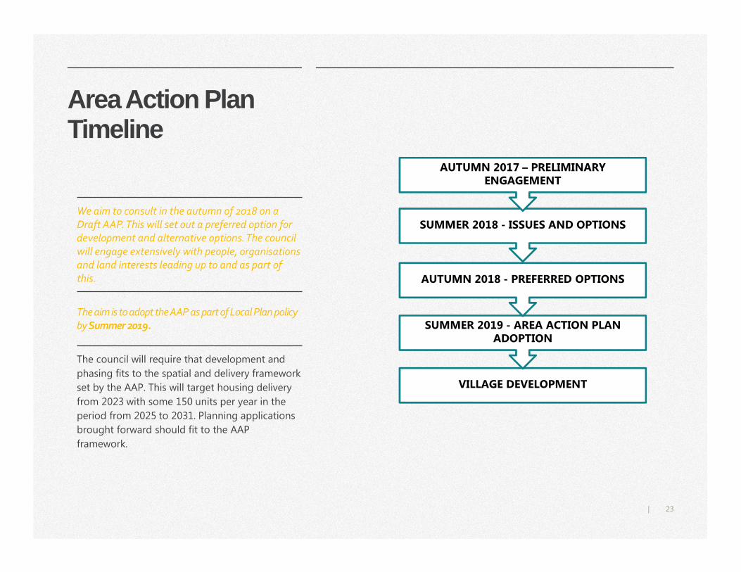
Area Action Plan Timeline
The council will require that development and
phasing fits to the spatial and delivery framework
set by the AAP. This will target housing delivery
from 2023 with some 150 units per year in the
period from 2025 to 2031. Planning applications
brought forward should fit to the AAP
framework.
We aim to consult in the autumn of 2018 on a
Draft AAP. This will set out a preferred option for
development and alternative options. The council
will engage extensively with people, organisations
and land interests leading up to and as part of
this.
The aim is to adopt the AAP as part of Local Plan policy
by Summer 2019.
VILLAGE DEVELOPMENT
SUMMER 2019 - AREA ACTION PLAN ADOPTION
AUTUMN 2018 - PREFERRED OPTIONS
SUMMER 2018 - ISSUES AND OPTIONS
AUTUMN 2017 – PRELIMINARY ENGAGEMENT
24|
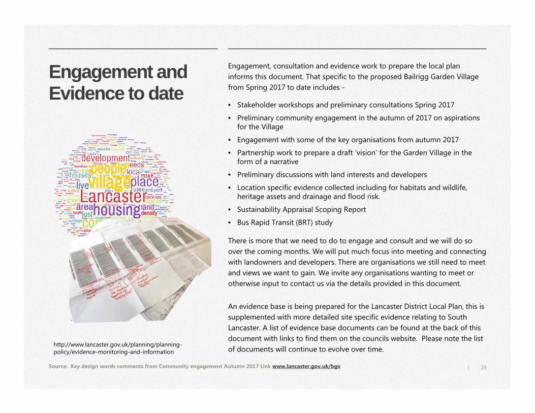
Engagement and Evidence to date
Engagement, consultation and evidence work to prepare the local plan
informs this document. That specific to the proposed Bailrigg Garden Village
from Spring 2017 to date includes -
• Stakeholder workshops and preliminary consultations Spring 2017
• Preliminary community engagement in the autumn of 2017 on aspirations for the Village
• Engagement with some of the key organisations from autumn 2017
• Partnership work to prepare a draft ‘vision’ for the Garden Village in the form of a narrative
• Preliminary discussions with land interests and developers
• Location specific evidence collected including for habitats and wildlife, heritage assets and drainage and flood risk.
• Sustainability Appraisal Scoping Report
• Bus Rapid Transit (BRT) study
There is more that we need to do to engage and consult and we will do so
over the coming months. We will put much focus into meeting and connecting
with landowners and developers. There are organisations we still need to meet
and views we want to gain. We invite any organisations wanting to meet or
otherwise input to contact us via the details provided in this document.
An evidence base is being prepared for the Lancaster District Local Plan, this is
supplemented with more detailed site specific evidence relating to South
Lancaster. A list of evidence base documents can be found at the back of this
document with links to find them on the councils website. Please note the list
of documents will continue to evolve over time.
Source: Key design words comments from Community engagement Autumn 2017 Link www.lancaster.gov.uk/bgv
http://www.lancaster.gov.uk/planning/planning-policy/evidence-monitoring-and-information
25|
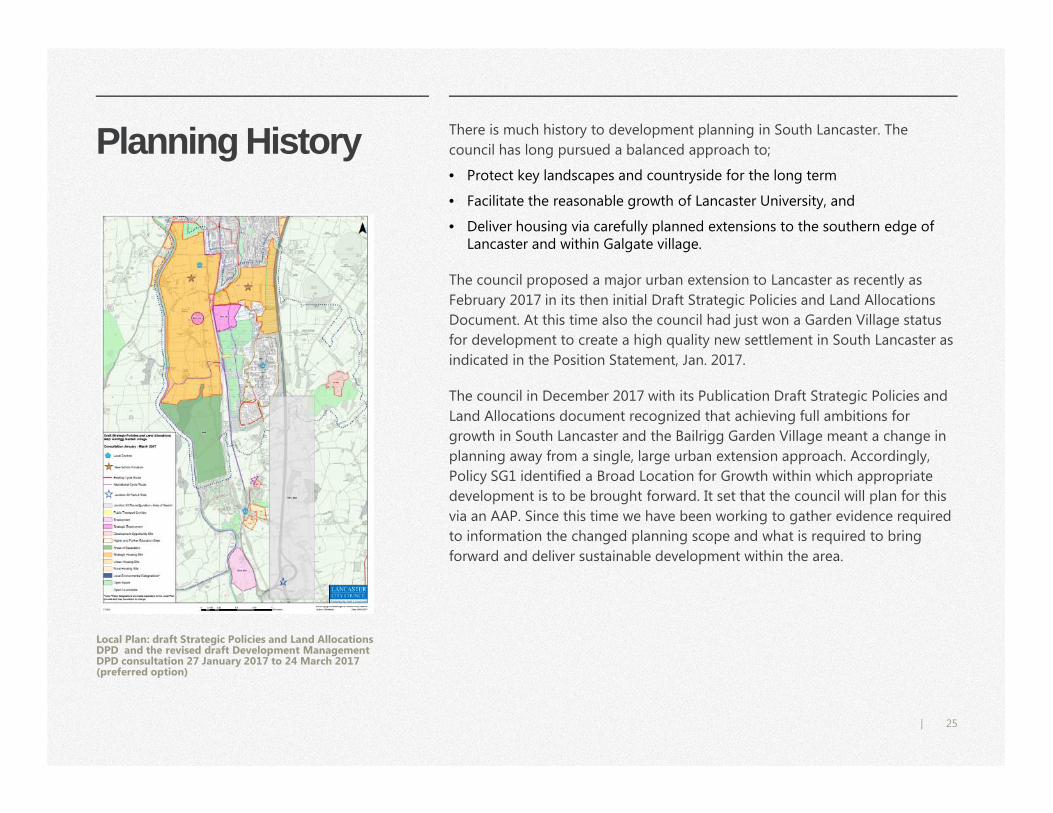
Planning History
Local Plan: draft Strategic Policies and Land Allocations DPD and the revised draft Development Management DPD consultation 27 January 2017 to 24 March 2017 (preferred option)
There is much history to development planning in South Lancaster. The
council has long pursued a balanced approach to;
• Protect key landscapes and countryside for the long term
• Facilitate the reasonable growth of Lancaster University, and
• Deliver housing via carefully planned extensions to the southern edge of Lancaster and within Galgate village.
The council proposed a major urban extension to Lancaster as recently as
February 2017 in its then initial Draft Strategic Policies and Land Allocations
Document. At this time also the council had just won a Garden Village status
for development to create a high quality new settlement in South Lancaster as
indicated in the Position Statement, Jan. 2017.
The council in December 2017 with its Publication Draft Strategic Policies and
Land Allocations document recognized that achieving full ambitions for
growth in South Lancaster and the Bailrigg Garden Village meant a change in
planning away from a single, large urban extension approach. Accordingly,
Policy SG1 identified a Broad Location for Growth within which appropriate
development is to be brought forward. It set that the council will plan for this
via an AAP. Since this time we have been working to gather evidence required
to information the changed planning scope and what is required to bring
forward and deliver sustainable development within the area.
26|
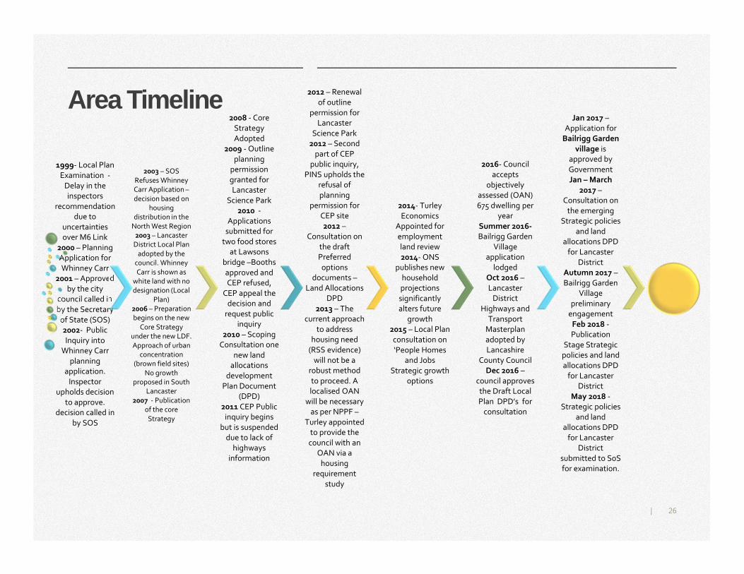
1999- Local Plan
Examination -
Delay in the
inspectors
recommendation
due to
uncertainties
over M6 Link
2000 – Planning
Application for
Whinney Carr
2001 – Approved
by the city
council called in
by the Secretary
of State (SOS)
2002- Public
Inquiry into
Whinney Carr
planning
application.
Inspector
upholds decision
to approve.
decision called in
by SOS
2003 – SOS
Refuses Whinney
Carr Application –
decision based on
housing
distribution in the
North West Region
2003 – Lancaster
District Local Plan
adopted by the
council. Whinney
Carr is shown as
white land with no
designation (Local
Plan)
2006 – Preparation
begins on the new
Core Strategy
under the new LDF.
Approach of urban
concentration
(brown field sites)
No growth
proposed in South
Lancaster
2007 - Publication
of the core
Strategy
2008 - Core
Strategy
Adopted
2009 - Outline
planning
permission
granted for
Lancaster
Science Park
2010 -
Applications
submitted for
two food stores
at Lawsons
bridge –Booths
approved and
CEP refused,
CEP appeal the
decision and
request public
inquiry
2010 – Scoping
Consultation one
new land
allocations
development
Plan Document
(DPD)
2011 CEP Public
inquiry begins
but is suspended
due to lack of
highways
information
2012 – Renewal
of outline
permission for
Lancaster
Science Park
2012 – Second
part of CEP
public inquiry,
PINS upholds the
refusal of
planning
permission for
CEP site
2012 –
Consultation on
the draft
Preferred
options
documents –
Land Allocations
DPD
2013 – The
current approach
to address
housing need
(RSS evidence)
will not be a
robust method
to proceed. A
localised OAN
will be necessary
as per NPPF –
Turley appointed
to provide the
council with an
OAN via a
housing
requirement
study
2014- Turley
Economics
Appointed for
employment
land review
2014- ONS
publishes new
household
projections
significantly
alters future
growth
2015 – Local Plan
consultation on
‘People Homes
and Jobs
Strategic growth
options
2016- Council
accepts
objectively
assessed (OAN)
675 dwelling per
year
Summer 2016-
Bailrigg Garden
Village
application
lodged
Oct 2016 –
Lancaster
District
Highways and
Transport
Masterplan
adopted by
Lancashire
County Council
Dec 2016 –
council approves
the Draft Local
Plan DPD’s for
consultation
Jan 2017 –
Application for
Bailrigg Garden
village is
approved by
Government
Jan – March
2017 –
Consultation on
the emerging
Strategic policies
and land
allocations DPD
for Lancaster
District
Autumn 2017 –
Bailrigg Garden
Village
preliminary
engagement
Feb 2018 -
Publication
Stage Strategic
policies and land
allocations DPD
for Lancaster
District
May 2018 -
Strategic policies
and land
allocations DPD
for Lancaster
District
submitted to SoS
for examination.
Area Timeline
27|
Making the Garden Village, Infrastructure Development and Funding
Most housing development and the neighbourhood fabric of the Garden
Village will be for the private sector to deliver. The Garden Village can only
happen if landowners, developers and builders get involved and pitch in to
make it possible. Viability considerations are crucial in this. Ambitions for the
Garden Village are rightly high and meeting these and funding infrastructure
will cost.
Expectations on developers will need to be balanced against potential returns
but the Garden Village cannot be about run of the mill development.
Significant growth and development at South Lancaster including for the
Garden Village depends on providing substantial new infrastructure including
J33 reconfiguration and for sustainable local transport and principally BRT.
The council will structure development to Bus Rapid Transit to make a
sustainable transport corridor between the city centre and South Lancaster.
The city and county councils will lead on infrastructure planning and much
delivery.
Much Government funding is required for the main transport infrastructure
but the private sector will need to contribute to infrastructure costs too. The
council will work with developers and landowners to agree a funding
mechanism(s).
Further information about transport infrastructure is available in the
‘Connecting People and Places’ chapter and other essential village
infrastructure in ‘Homes and Neighbourhoods for all.’
28|
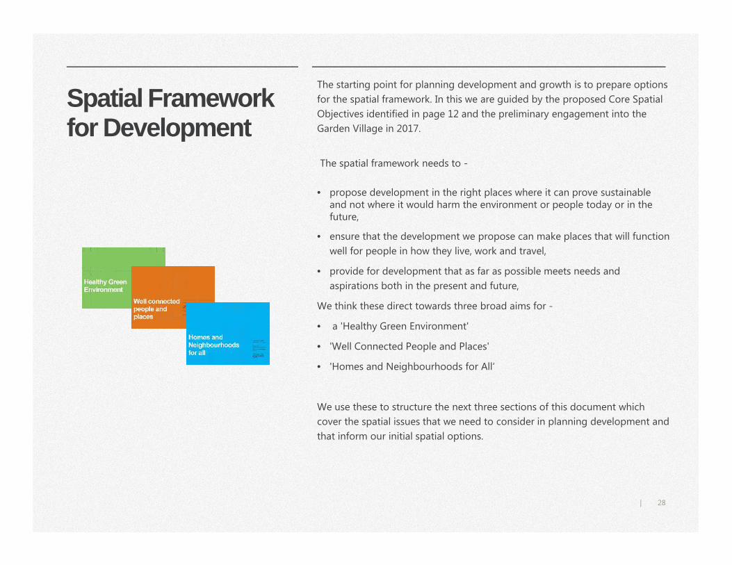
Spatial Framework for Development
The starting point for planning development and growth is to prepare options
for the spatial framework. In this we are guided by the proposed Core Spatial
Objectives identified in page 12 and the preliminary engagement into the
Garden Village in 2017.
The spatial framework needs to -
• propose development in the right places where it can prove sustainable and not where it would harm the environment or people today or in the future,
• ensure that the development we propose can make places that will function
well for people in how they live, work and travel,
• provide for development that as far as possible meets needs and
aspirations both in the present and future,
We think these direct towards three broad aims for -
• a 'Healthy Green Environment'
• 'Well Connected People and Places'
• 'Homes and Neighbourhoods for All‘
We use these to structure the next three sections of this document which
cover the spatial issues that we need to consider in planning development and
that inform our initial spatial options.
29|
Towards Spatial Options
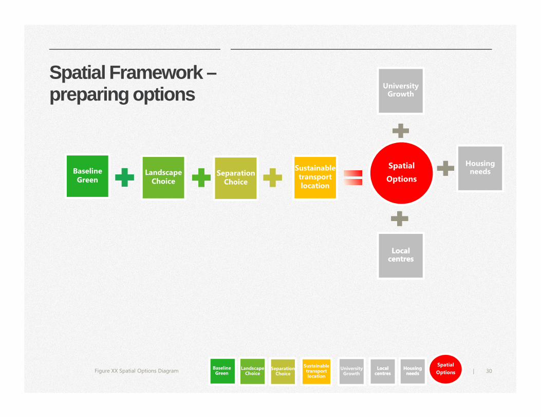
There are very many issues to consider in preparing spatial options. The diagram on page 31 attempts to describe how we have gone about this.
• Baseline Green - land that is the minimum we should reserve from development for the purposes of sustainable development to make a Healthy Green Environment.
• Landscape Choice - land that we might safeguard (in addition to the Baseline Green) for its landscape value because this will contribute further to sustainable development and a Healthy Green Environment.
• Separation Choice - closely related to the above, land that we might safeguard (in addition to the Baseline Green) because this would help make for visual separation between settlements and settlement coherence and / or conserve the green setting to existing settlements and so contribute to a Healthy Green Environment
• Sustainable Transport Locations – land that is or could be well served by sustainable transport towards making Well Connected People and Places.
• University Growth - consideration of University growth needs in the context of achieving Homes and Neighbourhoods for All.
• Local centres - consideration of issues and options towards making a strong village centre an essential component for Homes and Neighbourhoods for All.
• Housing Needs - factoring for the overarching need to plan for and deliver sufficient housing for the district to meet needs over time, creating Homes and Neighbourhoods for All.
The colour coding used in the diagram is employed on pages in the following three sections of this document to illustrate how issues fit to the above.
We invite views and comments on the issues presented.
In the final section of the
document we draw our
thinking together on these
and present initial spatial
options for the disposition
of development and use of
land.
Have we missed any?
Should we have
considered some issues
differently ?
Are our considerations
reasonable ? We invite comment on any aspect.
30|
Spatial Framework –preparing options
Separation Choice
Landscape Choice
Baseline Green
Sustainable Sustainable transport location
Spatial
Options
Figure XX Spatial Options Diagram
Local centresLocal
centres
University Growth
University Growth
Baseline Green
Landscape Choice
Separation Choice
Sustainable transport location
University Growth
University Growth
Local centresLocal
centres
Spatial
Options
Housing needs
Housing needs
Housing needs
Housing needs
31|
Planning the Garden Village
Q4 Do you have any comments or suggestions to make on this section?
Healthy Green Environment
Planning a blue / green
spatial framework
Wildlife and Habitats
Heritage assets and
archaeology
Managing Flood Risk
Drainage catchment and
Flood risk
Flood Risk and Drainage
Strategy
The most significant and
valued landscape
Separation choice
33|
34|
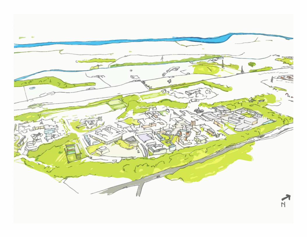
A Healthy Green Environment
To be true to the name, a green
setting is fundamental to the Garden
Village and to securing a high quality
development. The University campus
has achieved this well and this is
something to emulate.
The Garden Village must offer the
highest standards of sustainable
living through its built environment
and, in the opportunities this and the
green setting offer, for healthy
outdoor activity including sustainable
travel by walking and cycling.
This approach will support people to
enjoy as healthy and happy lives as
possible with private vehicle travel
and demands on conventional health
services minimised.
A carefully planned spatial framework
for development can ensure that the
Garden Village is set in a good green
setting from the outset and one that
will further improve as new tree and
woodland elements mature over time
- as did that at the University campus.
The green environment has vital
drainage functions too. Development
must fit to natural drainage systems
as much as possible and,
interventions to manage drainage
must be properly integrated into the
green environment.
Existing natural features and
landforms, trees and woodland,
hedgerows, streams and land
retained in agricultural use should all
contribute to the setting.
A green setting to
development
Green space and
greenery should thread
through development
and neighbourhoods.
Baseline Green
Landscape Choice
Separation Choice
35|
36|
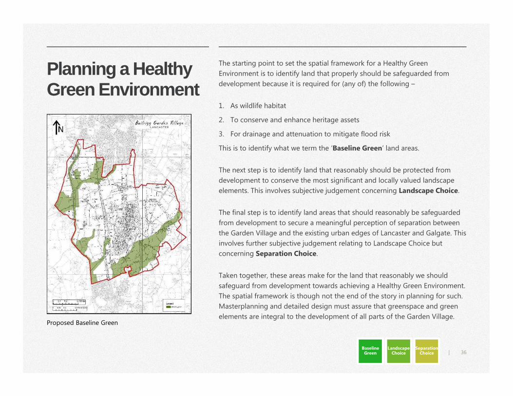
Planning a Healthy Green Environment
The starting point to set the spatial framework for a Healthy Green
Environment is to identify land that properly should be safeguarded from
development because it is required for (any of) the following –
1. As wildlife habitat
2. To conserve and enhance heritage assets
3. For drainage and attenuation to mitigate flood risk
This is to identify what we term the ‘Baseline Green’ land areas.
The next step is to identify land that reasonably should be protected from
development to conserve the most significant and locally valued landscape
elements. This involves subjective judgement concerning Landscape Choice.
The final step is to identify land areas that should reasonably be safeguarded
from development to secure a meaningful perception of separation between
the Garden Village and the existing urban edges of Lancaster and Galgate. This
involves further subjective judgement relating to Landscape Choice but
concerning Separation Choice.
Taken together, these areas make for the land that reasonably we should
safeguard from development towards achieving a Healthy Green Environment.
The spatial framework is though not the end of the story in planning for such.
Masterplanning and detailed design must assure that greenspace and green
elements are integral to the development of all parts of the Garden Village.Proposed Baseline Green
Baseline Green
Landscape Choice
Separation Choice
37|
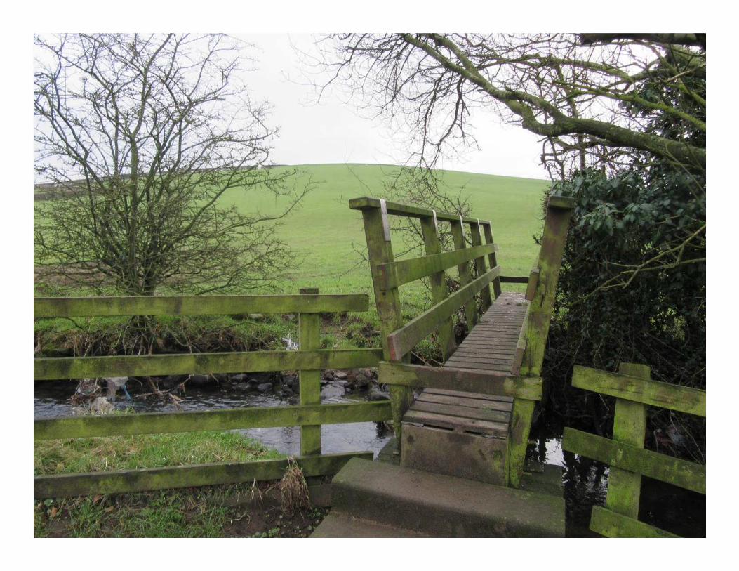
Wildlife and Habitats We will take a precautionary approach to conserve wildlife and habitats.
Certain areas must be safeguarded and reserved as greenspace for the wildlife
habitats. These afford or reasonably might readily afford given appropriate
stewardship and management to secure these for the future. These include -
• The Lancaster Canal
• Park Coppice (ancient woodland and county Biological Heritage Site) and
buffer
• Burrow Beck (county Biological Heritage Site)
• On campus woodland
• Woodlands east of the M6 and to the south of Hazelrigg Lane
• Areas with significant habitat potential including streams and streamsides
and associated areas of wetland.
Significant areas east of the M6 may have moderate, or above, potential as
estuarine habitats to support bird species associated with internationally
designated wildlife sites nearby. This requires further consideration.
The spatial framework should connect and integrate habitats where possible
to make green corridors for wildlife. Habitat value and wildlife is not though
exclusive to any defined framework. Conserving and enhancing wildlife must
be integral to the design of development, including to safeguard hedgerows,
trees, ponds (where at all possible) and to optimise opportunities for wildlife
as part of development.
Source: Greater Manchester Ecology Unit link to studyBaseline Green
38|
Heritage Assets and Archaeology
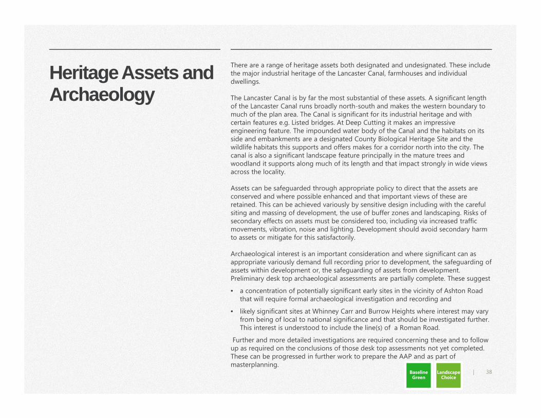
There are a range of heritage assets both designated and undesignated. These include the major industrial heritage of the Lancaster Canal, farmhouses and individual dwellings.
The Lancaster Canal is by far the most substantial of these assets. A significant length of the Lancaster Canal runs broadly north-south and makes the western boundary to much of the plan area. The Canal is significant for its industrial heritage and with certain features e.g. Listed bridges. At Deep Cutting it makes an impressive engineering feature. The impounded water body of the Canal and the habitats on its side and embankments are a designated County Biological Heritage Site and the wildlife habitats this supports and offers makes for a corridor north into the city. The canal is also a significant landscape feature principally in the mature trees and woodland it supports along much of its length and that impact strongly in wide views across the locality.
Assets can be safeguarded through appropriate policy to direct that the assets are conserved and where possible enhanced and that important views of these are retained. This can be achieved variously by sensitive design including with the careful siting and massing of development, the use of buffer zones and landscaping. Risks of secondary effects on assets must be considered too, including via increased traffic movements, vibration, noise and lighting. Development should avoid secondary harm to assets or mitigate for this satisfactorily.
Archaeological interest is an important consideration and where significant can as appropriate variously demand full recording prior to development, the safeguarding of assets within development or, the safeguarding of assets from development. Preliminary desk top archaeological assessments are partially complete. These suggest
• a concentration of potentially significant early sites in the vicinity of Ashton Road that will require formal archaeological investigation and recording and
• likely significant sites at Whinney Carr and Burrow Heights where interest may vary from being of local to national significance and that should be investigated further. This interest is understood to include the line(s) of a Roman Road.
Further and more detailed investigations are required concerning these and to follow up as required on the conclusions of those desk top assessments not yet completed. These can be progressed in further work to prepare the AAP and as part of masterplanning.
Baseline Green
Landscape Choice
39|
40|
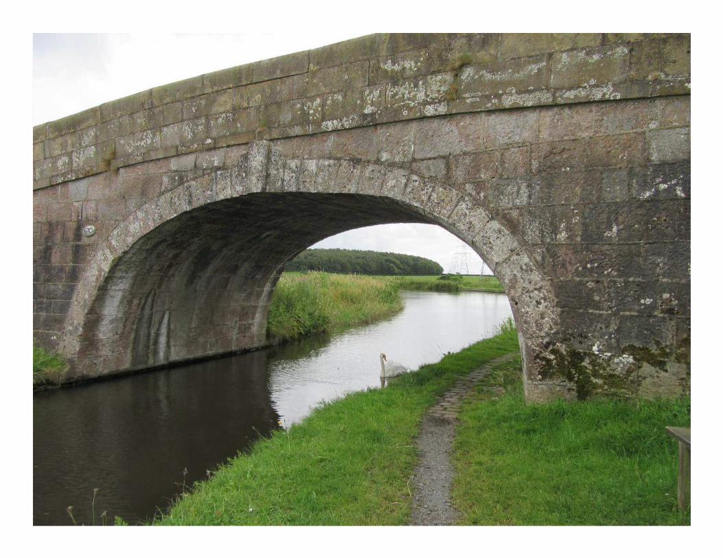
Park Coppice This ancient woodland is the largest area of woodland within the plan area
and must be retained in its entirety. Park Coppice is one of several relatively
small ancient woodlands in something of a swathe both north west and east
of Galgate and all remnant of much more extensive natural woodlands all lost
over centuries to clearance and grazing. Ancient woodlands are rich habitats
because they are long standing and at least semi-natural. But where ancient
woodland is quite small and isolated from complementary habitats the wildlife
interest can be vulnerable and diminish over time.
Development should be planned to reinforce the spatial connection between
Park Coppice, woodland by the Lancaster Canal and Old Park Wood to
reinforce the woodland ecosystem. Development should relate well to the
woodland and development that closes off the woodland or abuts abruptly
including with rear gardens is to be avoided.
Bringing forward the Garden Village should secure appropriate management
to conserve and enhance the woodland and its wildlife interest.
Baseline Green
41|
Managing Flood Risk
Managing water and drainage is a key concern for planning new development
and a major issue for local communities impacted in recent times by serious
flood events, including most recently in Galgate and other areas in November
2017.
We recognise that we must do all we reasonably can to bring forward
development in such a way that flood risk is managed as well as possible. We
will take a very precautionary approach in planning for drainage and to
mitigate flood risk. We will do this in what can be termed ‘blue/green’
planning, providing for effective drainage and measures to mitigate flood risk
as an integral part of planning greenspace and the spatial framework. A key
element is to identify that land we should not develop because it is not
prudent to do so given the implications to drainage and flood risk.
The management of flood risk is otherwise the responsibility of the lead flood
authorities. For the River Conder this is the Environment Agency and for Ou
Beck and Burrow Beck it is the Lancashire County Council as Lead local Flood
Authority. In addition to their continuing regulatory roles, their input to the
plan is essential.
Baseline Green
Landscape Choice
Concept Bailrigg flood risk and drainage strategy (JBA) March2018
Geo – environmental and groundwater flooding desk study(JBA) Jan 2018
Culvert surveys (JBA) Oct 2017
https://www.lancaster.gov.uk/planning/planning-policy/bailrigg-garden-village
42|
43|
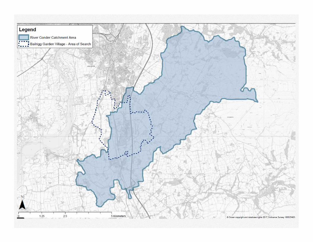
Drainage Catchment and Flood Risk
Planning development and managing flood risk requires an understanding of
river catchments. The greater part of the plan area lies within the catchment of
the River Conder. Flood from the River Conder represents the greatest risks to
Galgate. The AAP area covers only a very small proportion of the Conder
catchment but there may be opportunities to reduce flood risk to Galgate as
part of development.
The city and county councils and the Environment Agency will consider what
measures might bring forward as part of development to slow and hold water
coming down the Conder from the catchment up-river of Galgate.
Ou Beck drains a sub catchment of the Conder and risks some parts of
Galgate. The Ou Beck sub-catchment is relatively small but there are
considerable areas of low-lying land that could be utilised to store and hold
back water and there may be opportunities to direct some run off to the
Burrow Beck catchment instead.
The Burrow Beck catchment flows west to outfall into the River Lune.
Catchment runoff from this area does not risk Galgate and development
within this sub catchment would not impact on any other areas of known
flood risk.
Whitley Beck poses some flood risk to Galgate but is outside of the plan area.
The residential areas in Scotforth that flooded last year from Burrow Beck are
upstream of the plan area.
Concept Bailrigg flood risk and drainage strategy (JBA) March 2018 https://www.lancaster.gov.uk/planning/planning-policy/bailrigg-garden-village
Baseline Green
Landscape Choice
44|
Flood Risk and Drainage Strategy
We have prepared a Concept Drainage and Flood Risk Strategy to inform
the initial spatial options and will work up a full strategy for a preferred
spatial option (draft plan).
The Environment Agency maps risk of flood from rivers. The Concept
Strategy identifies these in combination with consideration of risks from
alluvial and groundwater flooding.
Taking a reasonably precautionary approach we will safeguard from
development all land in Flood Zones 2 and 3, plus land otherwise at risk of
alluvial and groundwater flood.
In addition, the full strategy will provide -
• how multi-purpose and accessible greenspace should make ‘blue green’
corridors with wetland, attenuation basins, drainage ditches and
watercourses enhanced for wildlife.
• On how to use water as an integral feature within the Garden Village.
• Information concerning robust sustainable urban drainage systems (SuDs)
to reasonably mitigate flood risk and, as a minimum, that any
development will result in no increase in surface water runoff and where
appropriate seek the retrospective fit of SuDs.
• more detail about those land areas at significant risk of flood - including
from surface water, groundwater and alluvial flood.
• how to achieve some net gains for communities downstream with
development designed to help reduce and better manage flood risks to
communities downstream.
Baseline Green
Landscape Choice
Link to The Concept Drainage and Flood Risk
Strategy
45|
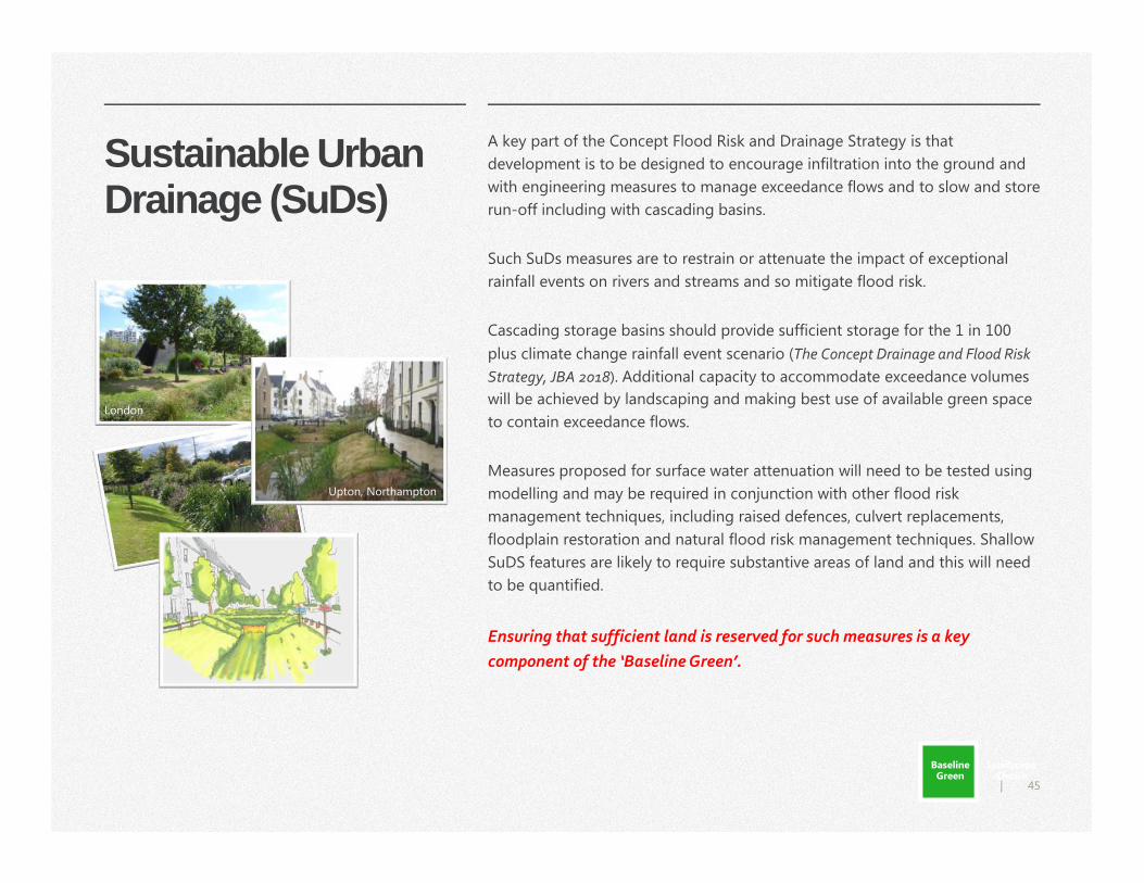
Sustainable Urban Drainage (SuDs)
A key part of the Concept Flood Risk and Drainage Strategy is that
development is to be designed to encourage infiltration into the ground and
with engineering measures to manage exceedance flows and to slow and store
run-off including with cascading basins.
Such SuDs measures are to restrain or attenuate the impact of exceptional
rainfall events on rivers and streams and so mitigate flood risk.
Cascading storage basins should provide sufficient storage for the 1 in 100
plus climate change rainfall event scenario (The Concept Drainage and Flood Risk
Strategy, JBA 2018). Additional capacity to accommodate exceedance volumes
will be achieved by landscaping and making best use of available green space
to contain exceedance flows.
Measures proposed for surface water attenuation will need to be tested using
modelling and may be required in conjunction with other flood risk
management techniques, including raised defences, culvert replacements,
floodplain restoration and natural flood risk management techniques. Shallow
SuDS features are likely to require substantive areas of land and this will need
to be quantified.
Ensuring that sufficient land is reserved for such measures is a key
component of the ‘Baseline Green’.
Upton, Northampton
London
Baseline Green
Landscape Choice
46|
The Most Significant and Valued Landscape
We think there is a need as a minimum to reserve the following areas from
development because of their significant contribution to the local landscape.
These are -
• certain prominent ridge tops and views including the greater part of the
Burrow Heights drumlin and part of the Whinney Carr drumlin
• land adjacent Burrow Beck and Ou Becks.
• Lancaster Canal
• Park Coppice
• Land in the Conder Valley
• Extensive areas east of the M6
Landscape Choice
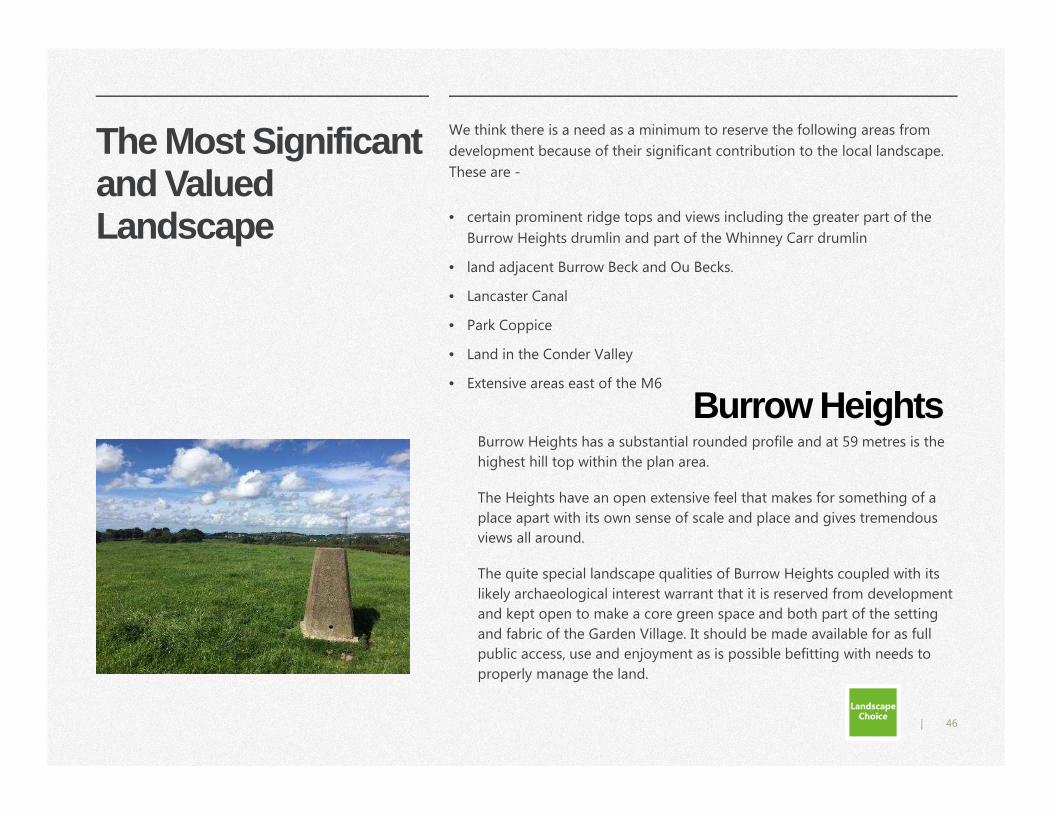
Burrow HeightsBurrow Heights has a substantial rounded profile and at 59 metres is the
highest hill top within the plan area.
The Heights have an open extensive feel that makes for something of a
place apart with its own sense of scale and place and gives tremendous
views all around.
The quite special landscape qualities of Burrow Heights coupled with its
likely archaeological interest warrant that it is reserved from development
and kept open to make a core green space and both part of the setting
and fabric of the Garden Village. It should be made available for as full
public access, use and enjoyment as is possible befitting with needs to
properly manage the land.
47|
48|
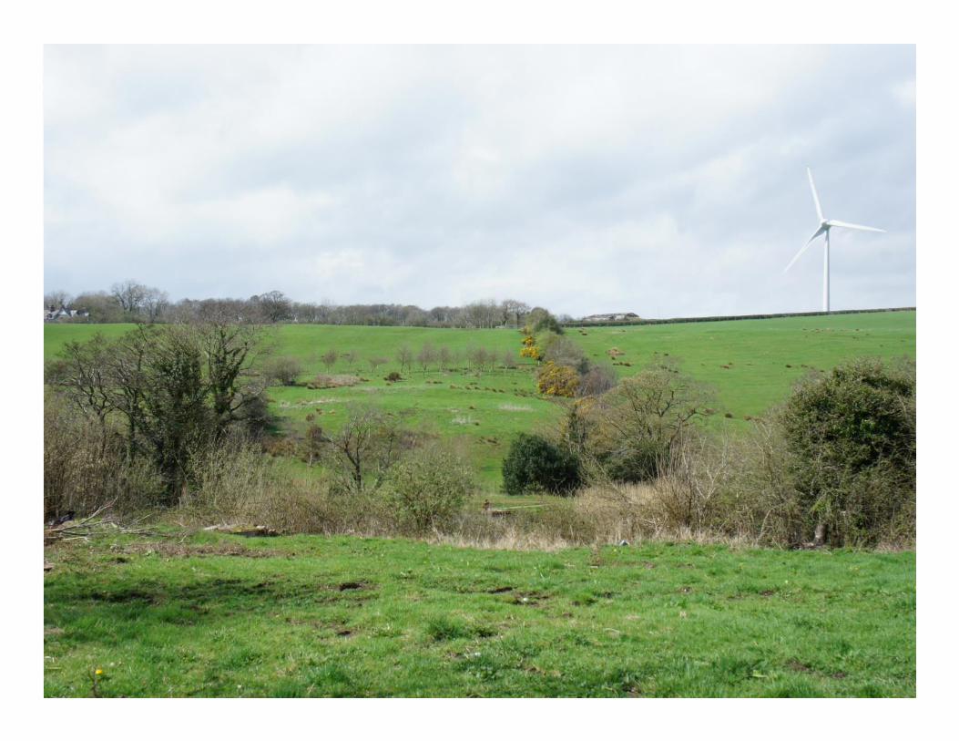
Land in the Conder Valley and east of the M6
Land in the Conder Valley and east of the M6 offers much landscape quality.
Flood risk considerations preclude development in much of the Conder Valley.
Much land otherwise east of the M6 is prominent when viewed from the east
including from vantage points within the Forest of Bowland AONB.
The topography of land here is quite incised and heavy wooded. There may be
some limited scope for development if carefully sited and of appropriate scale,
massing and design.
Source: LCC: Strategic sites landscape & visual assessment part 2.1: site 01 - Bailrigg Garden Village, (ARCADIS) Baseline Green
Landscape Choice
Source: Google Street view
49|
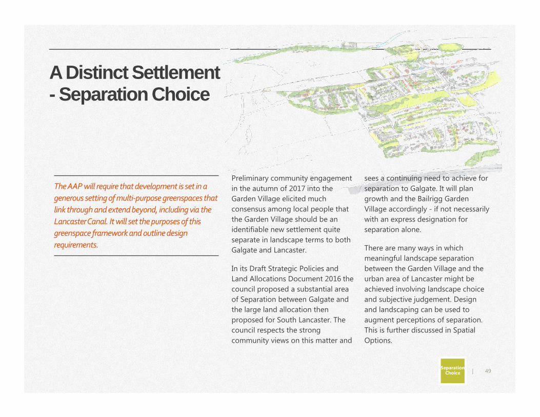
A Distinct Settlement - Separation Choice
Preliminary community engagement
in the autumn of 2017 into the
Garden Village elicited much
consensus among local people that
the Garden Village should be an
identifiable new settlement quite
separate in landscape terms to both
Galgate and Lancaster.
In its Draft Strategic Policies and
Land Allocations Document 2016 the
council proposed a substantial area
of Separation between Galgate and
the large land allocation then
proposed for South Lancaster. The
council respects the strong
community views on this matter and
sees a continuing need to achieve for
separation to Galgate. It will plan
growth and the Bailrigg Garden
Village accordingly - if not necessarily
with an express designation for
separation alone.
There are many ways in which
meaningful landscape separation
between the Garden Village and the
urban area of Lancaster might be
achieved involving landscape choice
and subjective judgement. Design
and landscaping can be used to
augment perceptions of separation.
This is further discussed in Spatial
Options.
The AAP will require that development is set in a
generous setting of multi-purpose greenspaces that
link through and extend beyond, including via the
Lancaster Canal. It will set the purposes of this
greenspace framework and outline design
requirements.
Separation Choice
50|
Healthy green environment
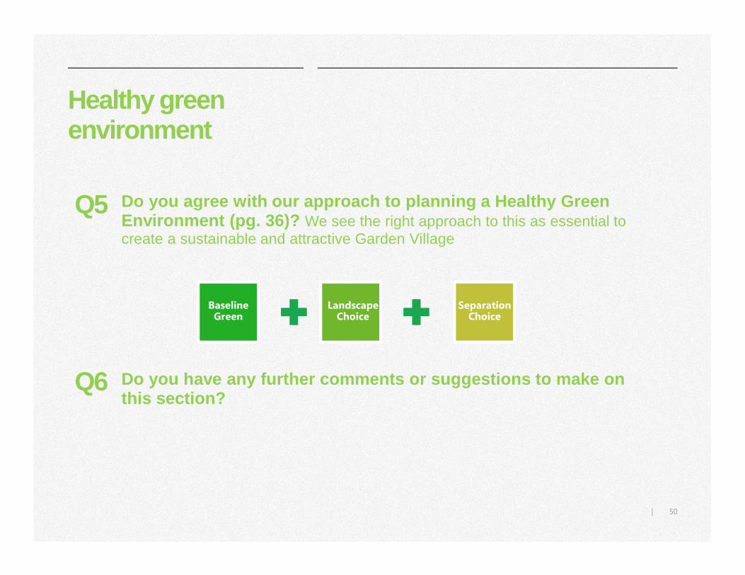
Do you agree with our approach to planning a Health y Green Environment (pg. 36)? We see the right approach to this as essential to create a sustainable and attractive Garden Village
Q5
Baseline Green
Landscape Choice
Separation Choice
Do you have any further comments or suggestions to make on this section?
Q6
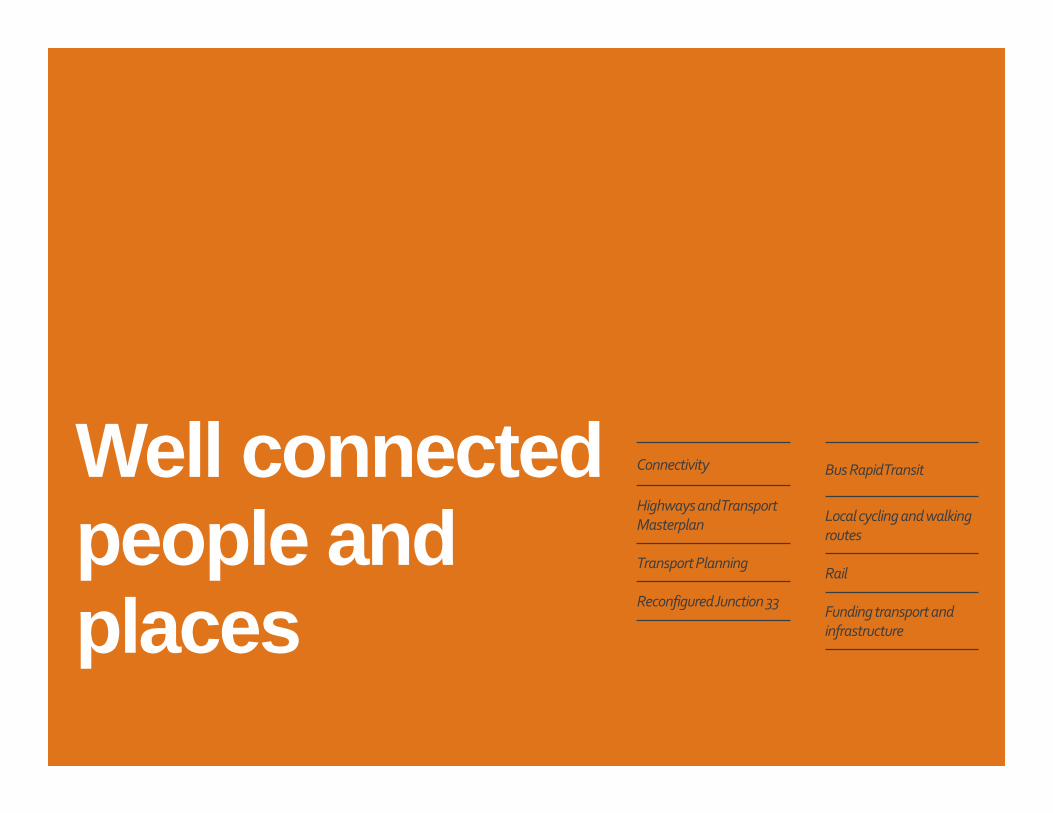
Well connected people and places
Connectivity
Highways and Transport
Masterplan
Transport Planning
Reconfigured Junction 33
Bus Rapid Transit
Local cycling and walking
routes
Rail
Funding transport and
infrastructure
52|
Connectivity For places to work and be attractive
to people over time people need to
be able to connect well with one
another, their places of work and the
places they need and want to visit.
This for the Bailrigg Garden Village
and development at South Lancaster
means making places that people
can readily move around, travel by
sustainable modes and optimising
digital connectivity.
Making the conditions for
sustainable travel favourable by
advantaging bus, walking and cycling
is crucial to securing a Healthy Green
Environment and, making places that
people want to live and work in over
time - Homes and Neighbourhoods
for All.
Connectivity is about
travel… and more. We are in a
digital era. For well-connected
people and places and for the digital
economy to really push on in
Lancaster it needs the impetus,
shared space, collaboration and
research links offered by the
University at the Bailrigg Campus.
The draft Local Vision narrative
suggests the Garden Village can add
a ‘digital dynamic’ as a place for
people to live and be entrepreneurial
with connected opportunities such as
‘digi-health’ linked to the new Health
Innovation Campus.
Assuring optimal broadband
provision must be a high priority and
is key to enabling and supporting
business activity at the Garden Village
and living / working flexibilities. There
will likely be much that we can do
and we invite views.
What might we do to help realise digital
potentials in the future?
53|
Highways and Transport Masterplan
Lancaster District Highways and Transport Masterplan 2016 http://www.lancashire.gov.uk/council/strategies-policies-plans/roads-parking-and-travel/highways-and-transport-masterplans/lancaster-district-highways-and-transport-masterplan/
The Highways and Transport Masterplan, Lancashire County Council, 2016 sets
the direction for transport planning within the district and is key to the context
for the AAP and planning growth and development at Lancaster South
including the Garden Village.
The Masterplan recognises that we cannot continue with current approaches
to travel and transport and that there must be radical change. It sets that high
traffic levels and at many times acute traffic congestion in particular on the
city centre gyratory, its approaches and along the A6 corridor and in Galgate
must be tackled. These make for extended travel times, delay and distort bus
services, impair and makes less safe conditions for pedestrians and cyclists
and, most important, impacts adversely on peoples’ safety and health through
adverse levels of air pollution. In turn, the economic performance, visitor
attraction and liveability of the city centre and around is held back by the long
prevailing poor traffic conditions and, without action such conditions things
can only get worse.
The Masterplan represents a decisive change in approach from, (by and large),
seeking to meet demands for private motorised travel to advantaging more
sustainable patterns of travel. This means reducing use of private vehicles
(together with making more efficient use of private vehicles) alongside
providing for much more travel by bus and more cycling and walking.
The Masterplan suggests such change in approach is vital for our economic,
social and environmental futures, to enable growth and to make good places
for people to live in, work in, visit and invest in.
Lancaster District
Highways and Transport
Masterplan 2016
The masterplan outlines a
range of improvements to
be developed by 2031
It aims to tackle problems
with congestion and air
pollution to support
economic growth
Sustainable transport location
54|
Growth, Transport and Sustainable Travel, Lancaster South
Growth and development at South
Lancaster cannot happen on any
scale without significant new
transport infrastructure.
Development that simply loads more
traffic on already congested roads
and in places suffering from acute
problems including air pollution is
not tenable.
The approach consistent with the
county council’s Highways and
Transport Masterplan is -
• For Caton Road to be the principal
gateway into the city centre for
traffic from the M6 via Junction 34
from both north and south. This
capitalises on the benefits of the
new M6 ‘Bay Gateway’ Link Road
and makes it possible to heavily
manage traffic in the city centre,
including via the J34 Park and Ride
facility.
• Involves change to transport in the
city centre to advantage Bus Rapid
Transit (BRT) and sustainable
travel.
• To transform connectivity to the
national road network from South
Lancaster via a reconfigured
Junction 33 to increase capacity
and directly connect into Lancaster
South avoiding Galgate.
• To make a true sustainable
transport corridor between
Lancaster South and the city
centre with good options for
people to travel by bus and where
possible to cycle and walk.
• To advantage cycling and walking
for local travel between the
University campus and the Garden
Village and within the Garden
Village and not travel by private
vehicles.
This approach can work with the right
infrastructure investment. It needs to
deliver real attractive travel choices
for local travel and, facilities to enable
people to switch mode of travel when
arriving in / departing South
Lancaster from the south and via
Junction 33. This demands well
integrated transport and land use
planning. Source: http://www.lancashire.gov.uk/council/strategies-policies-plans/roads-parking-and-travel/highways-and-transport-
masterplans/lancaster-district-highways-and-transport-masterplan/
55|
Transport PlanningThe city council has embed the Masterplan approach in its Publication
Strategic Policies and Land Allocations Document and the city and county
councils are working closely together to plan and deliver radical transport
change across the urban areas. Transport planning for development in South
Lancaster relates very closely to that for the city centre. The main strands of
transport planning now underway and being led by the county council are -
• To bring forward proposals to reconfigure J33
• Work towards a Movement Strategy for the city centre to re-work transport
and advantage sustainable travel with Bus Rapid Transit (BRT) the priority.
• Work on BRT route options with informal consultation forthcoming on
route options on the city centre – South Lancaster section.
• Work to plan for walking and cycling including the Cycle Superhighway and
via preparation of a Cycling and Walking Investment Plan
The AAP will factor for all of these. Bringing together all of this information
and more will support the stage 2 Housing Infrastructure Fund (HIF) co-
development phase working with Homes England.
Certain parts of the Broad Location for Growth are not well served by
sustainable transport options, nor might they feasibly be even with significant
new infrastructure.
Development can be advanced in locations well served with sustainable
transport options but not in locations otherwise and that reasonably cannot
be well served in the plan period. Decisions to come on sustainable transport
routes including BRT and the Cycle Superhighway and delivery of these will
make for change and improvements to sustainable transport and may make
certain locations appropriate for development where at present they are not.
Sustainable transport location
Although visual appearance
and the architecture of
individual buildings are very
important factors, securing
high quality and inclusive
design goes beyond aesthetic
considerations. Therefore,
planning policies and
decisions should address the
connections between people
and places and the
integration of new
development into the natural,
built and historic
environment.
National Planning Policy
Framework. Department for
Communities and Local
Government March 2016
56|
Transport Infrastructure
The main infrastructure proposed is -
• A reconfigured Junction 33 including to distribute traffic around Galgate.
• Park and walk, cycle or ride.
• New Bus Rapid Transit services between Lancaster South and the city centre
and over time as part of a wider system. This largely additional to existing
bus services.
• A Cycle Superhighway between South Lancaster and the city centre
• Dedicated cycle and walking routes within the Garden Village connecting
outward including to the Cycle Superhighway and direct to the University
campus.
• At least one crossing of the West Coast Main Line (WCML) to access land to
the west of the WCML and A6 Preston – Lancaster Road.
A railway station to serve the Lancaster university and south Lancaster can be
a long-term ambition.
The council will structure development to Bus Rapid Transit to make a
sustainable transport corridor between the city centre and South Lancaster.
The city and county councils will lead on infrastructure planning and much
delivery.
Comments and views on
BRT options are sought by
the county council. link.
Responses will inform
county council decisions on
this. In turn, these decisions
will inform work to come to
prepare the AAP.
Further AAP work will
include specific consultation
into options for the cycle
superhighway.Sustainable transport location
57|
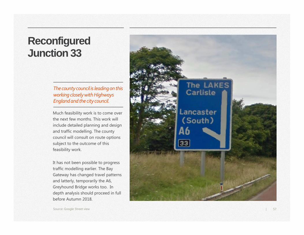
Reconfigured Junction 33
6.4
5.7
3.4
2.2
1.4
2.3
0
1
2
3
4
5
6
7
Category 1
Series 1 Series 2 Series 3 Series 4 Series 5 Series 6
Much feasibility work is to come over
the next few months. This work will
include detailed planning and design
and traffic modelling. The county
council will consult on route options
subject to the outcome of this
feasibility work.
It has not been possible to progress
traffic modelling earlier. The Bay
Gateway has changed travel patterns
and latterly, temporarily the A6,
Greyhound Bridge works too. In
depth analysis should proceed in full
before Autumn 2018.
Source: Google Street view
The county council is leading on this working closely with Highways England and the city council.
58|
Park and Walk, Cycle or Ride
This is subject to detailed investigation and feasibility work still to come
including as part of BRT planning and other consultations with the county
council, including for Junction 33 remodelling.
Well located and well designed, served by the BRT and with dedicated facilities
such as secure cycle parking and quality waiting shelters it should encourage
people to switch modes of travel
Located close by the University campus it should enable the following –
• Park and Walk to and from the campus and Galgate
• Park and Cycle to and from the campus, Galgate and the Garden Village
• Park and Ride to and from the campus and Lancaster, the city centre and
beyond
The city council indicates a possible site (on the sketch plan on page 93) that might be safeguarded for such a facility.
Sustainable transport location
59|
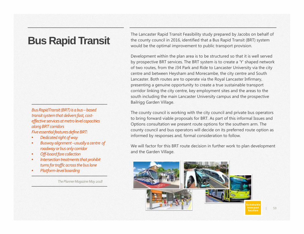
Bus Rapid Transit The Lancaster Rapid Transit Feasibility study prepared by Jacobs on behalf of
the county council in 2016, identified that a Bus Rapid Transit (BRT) system
would be the optimal improvement to public transport provision.
Development within the plan area is to be structured so that it is well served
by prospective BRT services. The BRT system is to create a ‘Y’ shaped network
of two routes, from the J34 Park and Ride to Lancaster University via the city
centre and between Heysham and Morecambe, the city centre and South
Lancaster. Both routes are to operate via the Royal Lancaster Infirmary,
presenting a genuine opportunity to create a true sustainable transport
corridor linking the city centre, key employment sites and the areas to the
south including the main Lancaster University campus and the prospective
Bailrigg Garden Village.
The county council is working with the city council and private bus operators
to bring forward viable proposals for BRT. As part of this informal Issues and
Options consultation we present route options for the southern arm. The
county council and bus operators will decide on its preferred route option as
informed by responses and, formal consideration to follow.
We will factor for this BRT route decision in further work to plan development
and the Garden Village.
Sustainable transport location
Bus Rapid Transit (BRT) is a bus – based
transit system that delivers fast, cost-
effective services at metro level capacities
along BRT corridors
Five essential features define BRT:
• Dedicated right of way
• Busway alignment –usually a centre of
roadway or bus only corridor
• Off-board fare collection
• Intersection treatments that prohibit
turns for traffic across the bus lane
• Platform-level boarding
The Planner Magazine May 2018
60|
Local Cycling and Walking Routes
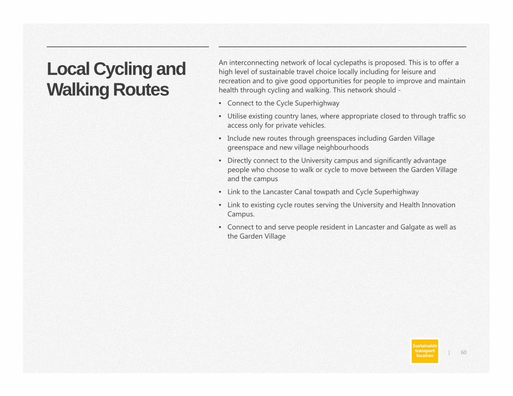
An interconnecting network of local cyclepaths is proposed. This is to offer a
high level of sustainable travel choice locally including for leisure and
recreation and to give good opportunities for people to improve and maintain
health through cycling and walking. This network should -
• Connect to the Cycle Superhighway
• Utilise existing country lanes, where appropriate closed to through traffic so
access only for private vehicles.
• Include new routes through greenspaces including Garden Village
greenspace and new village neighbourhoods
• Directly connect to the University campus and significantly advantage
people who choose to walk or cycle to move between the Garden Village
and the campus
• Link to the Lancaster Canal towpath and Cycle Superhighway
• Link to existing cycle routes serving the University and Health Innovation
Campus.
• Connect to and serve people resident in Lancaster and Galgate as well as
the Garden Village
Sustainable transport location
61|
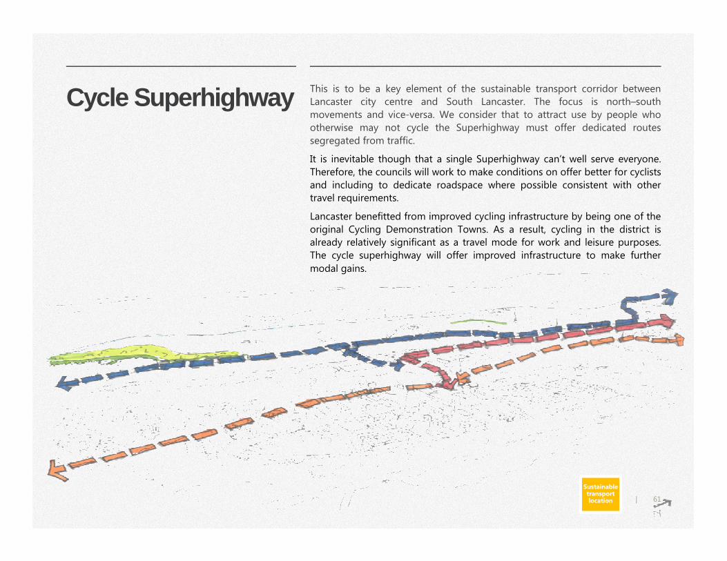
Cycle Superhighway This is to be a key element of the sustainable transport corridor between
Lancaster city centre and South Lancaster. The focus is north–south
movements and vice-versa. We consider that to attract use by people who
otherwise may not cycle the Superhighway must offer dedicated routes
segregated from traffic.
It is inevitable though that a single Superhighway can’t well serve everyone.
Therefore, the councils will work to make conditions on offer better for cyclists
and including to dedicate roadspace where possible consistent with other
travel requirements.
Lancaster benefitted from improved cycling infrastructure by being one of the
original Cycling Demonstration Towns. As a result, cycling in the district is
already relatively significant as a travel mode for work and leisure purposes.
The cycle superhighway will offer improved infrastructure to make further
modal gains.
Sustainable transport location

62|
Rail
One element in planning development in the locality and the Garden Village
is to look forward and factor for the prospect of improvements to the main
line rail infrastructure. Ever increasing capacity issues on the main line and
the potentials for significant development and improvement in train services
post HS2 are the key contexts. Network Rail and the county council as local
transport authority will advise as appropriate including as to the use of buffer
zones to stand development back from the main line.
As per the Lancaster Rapid Transit Feasibility Study, 2016 an ambition of
many people is for a rail station to serve the University. In the context of
existing main line service capacity and service operational needs this is not
feasible in the short to medium terms but we should not preclude ability to
achieve this ambition over the long term. The council will be guided in how
to factor for this by Network Rail and the county council. Prospectively, we
might expressly safeguard land for future rail transport infrastructure
including a station (we indicate a possible location in the sketch plan on page
93). We will also work to provide at least one crossing of the West Coast
Main Line (WCML) to access land to the west of the WCML and A6 Preston –
Lancaster Road.
Sustainable transport location
63|
Funding Transport and Infrastructure
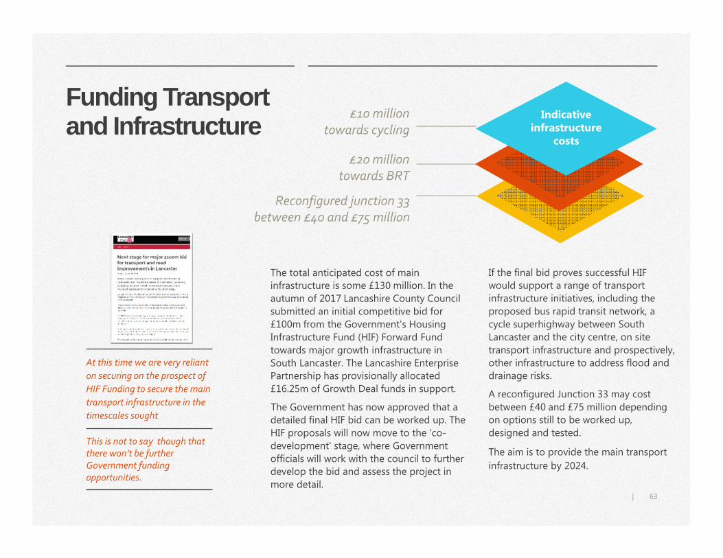
The total anticipated cost of main
infrastructure is some £130 million. In the
autumn of 2017 Lancashire County Council
submitted an initial competitive bid for
£100m from the Government's Housing
Infrastructure Fund (HIF) Forward Fund
towards major growth infrastructure in
South Lancaster. The Lancashire Enterprise
Partnership has provisionally allocated
£16.25m of Growth Deal funds in support.
The Government has now approved that a
detailed final HIF bid can be worked up. The
HIF proposals will now move to the 'co-
development' stage, where Government
officials will work with the council to further
develop the bid and assess the project in
more detail.
If the final bid proves successful HIF
would support a range of transport
infrastructure initiatives, including the
proposed bus rapid transit network, a
cycle superhighway between South
Lancaster and the city centre, on site
transport infrastructure and prospectively,
other infrastructure to address flood and
drainage risks.
A reconfigured Junction 33 may cost
between £40 and £75 million depending
on options still to be worked up,
designed and tested.
The aim is to provide the main transport
infrastructure by 2024.
At this time we are very reliant
on securing on the prospect of
HIF Funding to secure the main
transport infrastructure in the
timescales sought
This is not to say though that there won’t be further Government funding opportunities.
Indicative infrastructure
costs
Reconfigured junction 33
between £40 and £75 million
£20 million
towards BRT
£10 million
towards cycling
64|
Well connected people and places
Do you have any further comments or suggestions to make on this section?
Q7
Sustainable transport location
The overall approach to transport in Lancaster is e stablished via the Lancaster District Highways and Transport Masterpla n. Do you agree that the Garden Village should be structured around sustainable transport provision and particularly, Bus Rapid Tra nsit (BRT) (pg.56)?
Q8
Homes and Neighbourhoods for all
A place for generations,
village living and working
Village design
Housing and development
density
Sustaining the Village,
community and social
ownership
66|
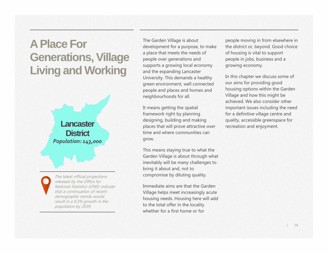
A Place For Generations, Village Living and Working
The Garden Village is about
development for a purpose, to make
a place that meets the needs of
people over generations and
supports a growing local economy
and the expanding Lancaster
University. This demands a healthy
green environment, well connected
people and places and homes and
neighbourhoods for all.
It means getting the spatial
framework right by planning
designing, building and making
places that will prove attractive over
time and where communities can
grow.
This means staying true to what the
Garden Village is about through what
inevitably will be many challenges to
bring it about and, not to
compromise by diluting quality.
Immediate aims are that the Garden
Village helps meet increasingly acute
housing needs. Housing here will add
to the total offer in the locality
whether for a first home or for
people moving in from elsewhere in
the district or, beyond. Good choice
of housing is vital to support
people in jobs, business and a
growing economy.
In this chapter we discuss some of
our aims for providing good
housing options within the Garden
Village and how this might be
achieved. We also consider other
important issues including the need
for a definitive village centre and
quality, accessible greenspace for
recreation and enjoyment.
The latest official projections released by the Office for National Statistics (ONS) indicate that a continuation of recent demographic trends would result in a 9.3% growth in the population by 2039.
Lancaster District
Population: 143,000
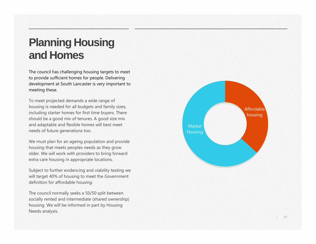
67|
Planning Housing and Homes
Affordable
housing
Market
Housing
The council has challenging housing targets to meet
to provide sufficient homes for people. Delivering
development at South Lancaster is very important to
meeting these.
To meet projected demands a wide range of
housing is needed for all budgets and family sizes,
including starter homes for first time buyers. There
should be a good mix of tenures. A good size mix
and adaptable and flexible homes will best meet
needs of future generations too.
We must plan for an ageing population and provide
housing that meets peoples needs as they grow
older. We will work with providers to bring forward
extra care housing in appropriate locations.
Subject to further evidencing and viability testing we
will target 40% of housing to meet the Government
definition for affordable housing.
The council normally seeks a 50/50 split between
socially rented and intermediate (shared ownership)
housing. We will be informed in part by Housing
Needs analysis.
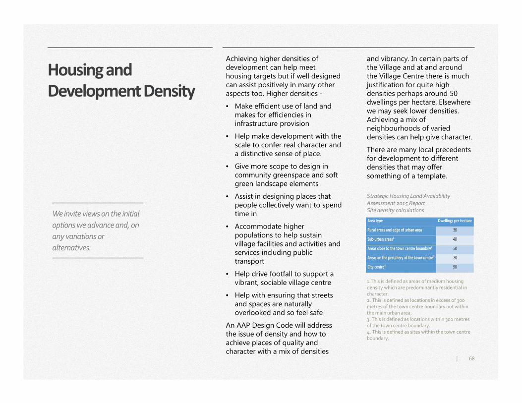
68|
Housing and
Development Density
and vibrancy. In certain parts of the Village and at and around the Village Centre there is much justification for quite high densities perhaps around 50 dwellings per hectare. Elsewhere we may seek lower densities. Achieving a mix of neighbourhoods of varied densities can help give character.
There are many local precedents for development to different densities that may offer something of a template.
Achieving higher densities of development can help meet housing targets but if well designed can assist positively in many other aspects too. Higher densities -
• Make efficient use of land and makes for efficiencies in infrastructure provision
• Help make development with the scale to confer real character and a distinctive sense of place.
• Give more scope to design in community greenspace and soft green landscape elements
• Assist in designing places that people collectively want to spend time in
• Accommodate higher populations to help sustain village facilities and activities and services including public transport
• Help drive footfall to support a vibrant, sociable village centre
• Help with ensuring that streets and spaces are naturally overlooked and so feel safe
An AAP Design Code will address the issue of density and how to achieve places of quality and character with a mix of densities
1.This is defined as areas of medium housing density which are predominantly residential in character.2. This is defined as locations in excess of 300 metres of the town centre boundary but within the main urban area.3. This is defined as locations within 300 metres of the town centre boundary.4. This is defined as sites within the town centre boundary.
Strategic Housing Land Availability
Assessment 2015 Report
Site density calculations We invite views on the initial
options we advance and, on
any variations or
alternatives.
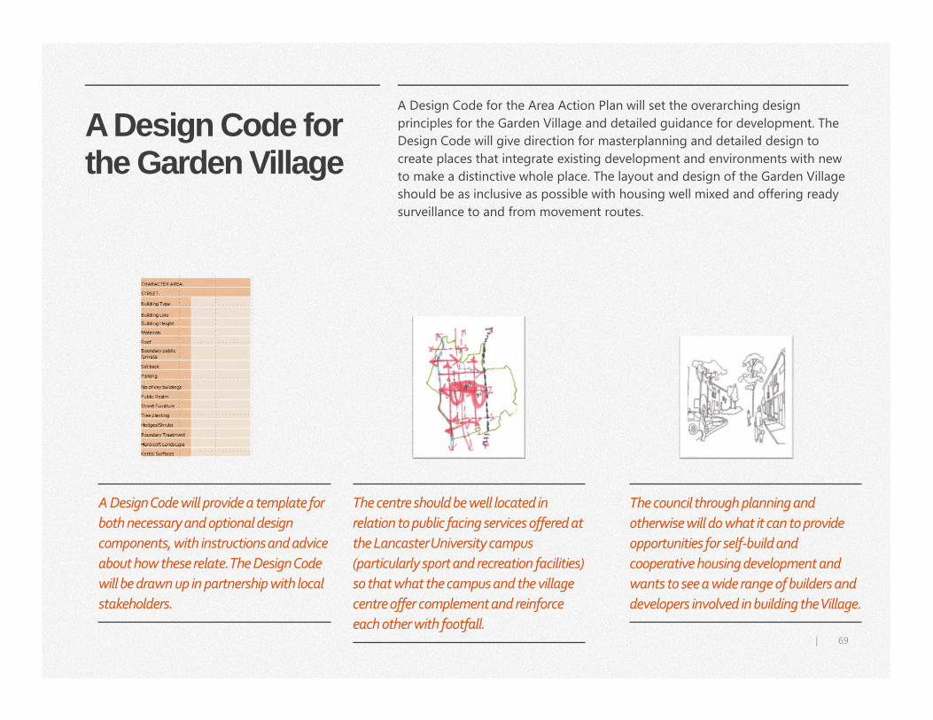
69|
A Design Code for the Garden Village
A Design Code for the Area Action Plan will set the overarching design
principles for the Garden Village and detailed guidance for development. The
Design Code will give direction for masterplanning and detailed design to
create places that integrate existing development and environments with new
to make a distinctive whole place. The layout and design of the Garden Village
should be as inclusive as possible with housing well mixed and offering ready
surveillance to and from movement routes.
The council through planning and
otherwise will do what it can to provide
opportunities for self-build and
cooperative housing development and
wants to see a wide range of builders and
developers involved in building the Village.
The centre should be well located in
relation to public facing services offered at
the Lancaster University campus
(particularly sport and recreation facilities)
so that what the campus and the village
centre offer complement and reinforce
each other with footfall.
A Design Code will provide a template for
both necessary and optional design
components, with instructions and advice
about how these relate. The Design Code
will be drawn up in partnership with local
stakeholders.
70|
Village Centre LOCATION – The Garden Village
should have a strong centre that
offers a range of facilities and
services, is a meeting place and gives
identity. It needs to be as busy or
vibrant as possible with sufficient
footfall to sustain services over time.
This requires that the centre is well
located at the hub of local bus, cycle
and walking provision, as well as by
private vehicle travel routes both in
relation to the Garden Village around
and to the University campus.
DESIGN – The centre should be
built to a higher density than
elsewhere to help make a vibrant
centre with good footfall. The north-
south alignment of Burrow Road can
make a good transport spine for the
Garden Village centre itself but
should be access only for vehicles
and dedicated as far as possible to
shared pedestrian and cyclist use
utilising informal street treatments as
appropriate. Such an approach can
help make an attractive focus to the
centre.
OFFER- The village centre should
be a local centre in planning terms
fitting to the established retail
hierarchy for the district. This means
that the convenience shopping offer
should serve local needs i.e. be for
the village itself and immediately
around and, in this context, also offer
some services attractive to people
both working and resident at the
University campus.
Local centresLocal
centres
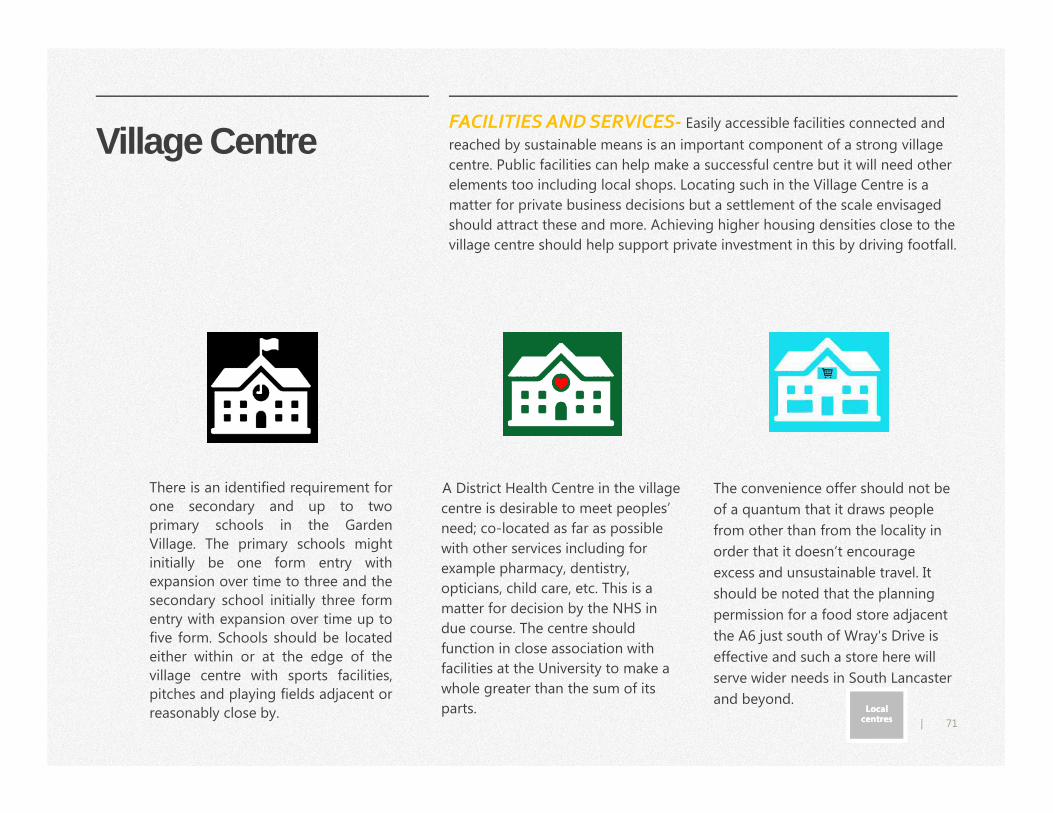
71|
Village Centre
A District Health Centre in the village
centre is desirable to meet peoples’
need; co-located as far as possible
with other services including for
example pharmacy, dentistry,
opticians, child care, etc. This is a
matter for decision by the NHS in
due course. The centre should
function in close association with
facilities at the University to make a
whole greater than the sum of its
parts.
The convenience offer should not be
of a quantum that it draws people
from other than from the locality in
order that it doesn’t encourage
excess and unsustainable travel. It
should be noted that the planning
permission for a food store adjacent
the A6 just south of Wray's Drive is
effective and such a store here will
serve wider needs in South Lancaster
and beyond.
There is an identified requirement for
one secondary and up to two
primary schools in the Garden
Village. The primary schools might
initially be one form entry with
expansion over time to three and the
secondary school initially three form
entry with expansion over time up to
five form. Schools should be located
either within or at the edge of the
village centre with sports facilities,
pitches and playing fields adjacent or
reasonably close by.
FACILITIES AND SERVICES- Easily accessible facilities connected and
reached by sustainable means is an important component of a strong village
centre. Public facilities can help make a successful centre but it will need other
elements too including local shops. Locating such in the Village Centre is a
matter for private business decisions but a settlement of the scale envisaged
should attract these and more. Achieving higher housing densities close to the
village centre should help support private investment in this by driving footfall.
Local centresLocal
centres
72|
Healthy Outdoor Exercise, Sport and Recreation
The Garden Village must offer good opportunities for healthy
outdoor activity with -
• Walking, running and cycle routes that make meaningful
local links and connections and offer multiple local circuits and
longer circuits and routes beyond.
• Informal play areas, informal kickabout and play space and
outdoor gym facilities.
• Places to relax, spend time in, and be close to nature.
• Places for young people to meet at and hang out in, from a
basket ball net to a multi use games area.
• Play and sports facilities on walking and cycle routes and close to
highways so readily accessed and overlooked.
• Open space and facilities readily accessible from all parts of the
Village, the University campus and by people in South Lancaster,
Galgate.
• Greenspace close by the Village centre and that wraps round and
weaves through housing areas.
73|
Village Sports Pitches
The Garden Village must be well served with sports facilities and pitches.
Elements of this are effectively ready made with the excellent public facing
University recreation facilities on campus – elements of which such as the
Sports Centre and way beyond the level of what could likely be secured as
part of Village development otherwise. The Garden Village cannot be wholly
reliant on these though given the University must prioritise its students and
staff if there are capacity issues. Further, there are facilities that the Village
may want not available on campus.
We invite views on the range of new sports facilities that may be needed for
the Village? A village cricket pitch is one suggestion made to date and there
will be many more. The topography gives much scope to locate pitches east of
the suggested preferred village centre. We will consider all suggestions and
work up detailed proposals to ensure that provision of sports facilities and
pitches for the Village will well serve demands in conjunction with the
University.
74|
Village Greenspace Land to be reserved from
development as it is needed to
make a healthy, green
environment for the Garden
Village is identified in Spatial
Options as ‘Village Greenspace’.
Village Greenspace will be
predominantly multipurpose and
should be managed as such where
at all possible. The aim is that
Village Greenspace makes a
coherent network interlaced by
walking and cycle routes. The AAP
will require that development
proposals optimise network
connectivity for the benefit of
people and wildlife.
Village Greenspace should include
for sports pitches and recreation
areas within development areas
but as yet to be planned.
Village greenspace should-
• be open and accessible to the
public consistent with the
needs to properly conserve
habitats and wildlife
• Be readily accessed from
housing neighbourhoods
• Give good, varied opportunities
for exercise and enjoyment by
all groups of people and all
mobilities including for informal
children's’ play and outdoor
gyms
• Integrate well to University
campus green space
• Link well to cycle and walking
routes outward including via
the Lancaster Canal and via
country lanes and Public Rights
of Way.
The council will explore all options in preparing the AAP
including investigating the viability of managing as a Country
Park
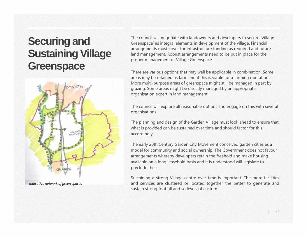
75|
Securing and Sustaining Village Greenspace
The council will negotiate with landowners and developers to secure ‘Village
Greenspace’ as integral elements in development of the village. Financial
arrangements must cover for infrastructure funding as required and future
land management. Robust arrangements need to be put in place for the
proper management of Village Greenspace.
There are various options that may well be applicable in combination. Some
areas may be retained as farmland if this is viable for a farming operation.
More multi-purpose areas of greenspace might still be managed in part by
grazing. Some areas might be directly managed by an appropriate
organisation expert in land management.
The council will explore all reasonable options and engage on this with several
organisations.
Indicative network of green spaces
The planning and design of the Garden Village must look ahead to ensure that
what is provided can be sustained over time and should factor for this
accordingly.
The early 20th Century Garden City Movement conceived garden cities as a
model for community and social ownership. The Government does not favour
arrangements whereby developers retain the freehold and make housing
available on a long leasehold basis and it is understood will legislate to
preclude these.
Sustaining a strong Village centre over time is important. The more facilities
and services are clustered or located together the better to generate and
sustain strong footfall and so levels of custom.
76|
Homes and Neighbourhoods for All
Do you have any further comments or suggestions to make on this section?
Q9 Do you agree that we should seek higher densities o f development where appropriate, for example in and a round the village centre (pg.68)? We see this as important to making places that work and are distinctive and have character.
Q10
Spatial Options Issues and Options
Engagement
Initial Spatial Options
Initial Options Assessment
Village Centre options
Broad Transport Approach
– early thinking
Cycle superhighway
Work to prepare Preferred
Spatial Option and a Draft
AAP
Delivery
78|
Issues and Options Engagement
Informed by all evidence gathered
and engagement to date we present
initial spatial options for
development in South Lancaster and
the Garden Village. The focus of
these is to propose how
development might be disposed
across the Broad Location for
Growth.
Closely related to this we summarise
our consideration of options for a
Village Centre and Village
Greenspace. Further, concerning
travel and transport and the
infrastructure required we share our
early and very much outline thinking
about the broad approach to provide
transport access and good
sustainable travel choice for the
Garden Village. We take the
opportunity to test people’s
aspirations for a Cycle Superhighway.
Comments are sought on a Draft
Sustainability Appraisal (SA) for the
Initial Spatial Options. SA will inform
successive stages in plan making and
will cover for the requirements of
Strategic Environment Assessment.
All options and information
presented are without prejudice to
consideration and decisions to come
in formal stages to prepare the AAP
and including via formal consultation
into preferred options.
Supporting this issues and options
engagement the county council
consults informally on route options
for Bus Rapid Transit for the southern
arm of the proposed system. This
will inform the county council in
further development work towards
formal consultation into BRT route
options. To remind, we intend to
structure development and the
Garden Village as far as possible to
sustainable transport provision and,
as a priority, BRT.
We invite views on the initial
options we advance and, on
any variations or
alternatives.
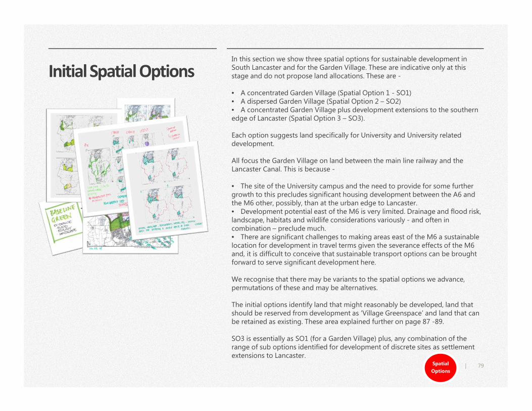
79|
Initial Spatial OptionsIn this section we show three spatial options for sustainable development in South Lancaster and for the Garden Village. These are indicative only at this stage and do not propose land allocations. These are -
• A concentrated Garden Village (Spatial Option 1 - SO1) • A dispersed Garden Village (Spatial Option 2 – SO2) • A concentrated Garden Village plus development extensions to the southern edge of Lancaster (Spatial Option 3 – SO3).
Each option suggests land specifically for University and University related development.
All focus the Garden Village on land between the main line railway and the Lancaster Canal. This is because -
• The site of the University campus and the need to provide for some further growth to this precludes significant housing development between the A6 and the M6 other, possibly, than at the urban edge to Lancaster. • Development potential east of the M6 is very limited. Drainage and flood risk, landscape, habitats and wildlife considerations variously - and often in combination – preclude much.• There are significant challenges to making areas east of the M6 a sustainable location for development in travel terms given the severance effects of the M6and, it is difficult to conceive that sustainable transport options can be brought forward to serve significant development here.
We recognise that there may be variants to the spatial options we advance, permutations of these and may be alternatives.
The initial options identify land that might reasonably be developed, land that should be reserved from development as ‘Village Greenspace’ and land that can be retained as existing. These area explained further on page 87 -89.
SO3 is essentially as SO1 (for a Garden Village) plus, any combination of the range of sub options identified for development of discrete sites as settlement extensions to Lancaster.
Spatial
Options
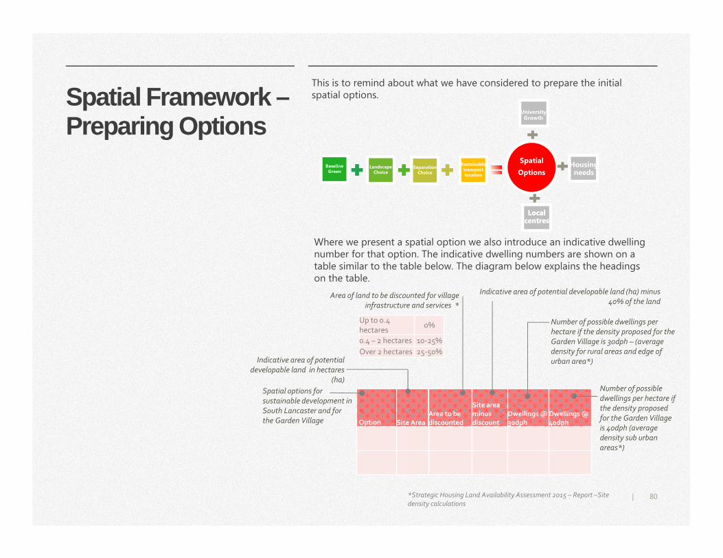
80|
Spatial Framework –Preparing Options
Separation Choice
Landscape Choice
Baseline Green
Sustainable Sustainable transport location
Spatial
Options
Local centresLocal
centres
University Growth
University Growth
Housing needs
Housing needs
Option Site Area Area to be discounted
Site area minus discount
Dwellings @ 30dph
Dwellings @ 40dph
Up to 0.4
hectares 0%
0.4 – 2 hectares 10-25%
Over 2 hectares 25-50% Indicative area of potential
developable land in hectares
(ha)
Area of land to be discounted for village
infrastructure and services *
Number of possible dwellings per
hectare if the density proposed for the
Garden Village is 30dph – (average
density for rural areas and edge of
urban area*)
Number of possible
dwellings per hectare if
the density proposed
for the Garden Village
is 40dph (average
density sub urban
areas*)
Indicative area of potential developable land (ha) minus
40% of the land
Spatial options for
sustainable development in
South Lancaster and for
the Garden Village
Where we present a spatial option we also introduce an indicative dwelling number for that option. The indicative dwelling numbers are shown on a table similar to the table below. The diagram below explains the headings on the table.
*Strategic Housing Land Availability Assessment 2015 – Report –Site density calculations
This is to remind about what we have considered to prepare the initial spatial options.
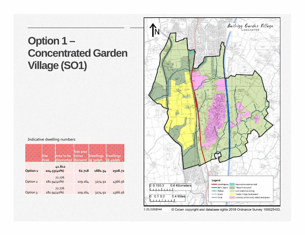
81|
Option 1 –Concentrated Garden Village (SO1)
Site
Area
Area to be
discounted
Site area
minus
discount
Dwellings
@ 30dph
Dwellings
@ 40dph
Option 1 104.53
41.812
(40%) 62.718 1881.54 2508.72
Option 2 181.94
72.776
(40%) 109.164 3274.92 4366.56
Option 3 181.94
72.776
(40%) 109.164 3274.92 4366.56
Indicative dwelling numbers
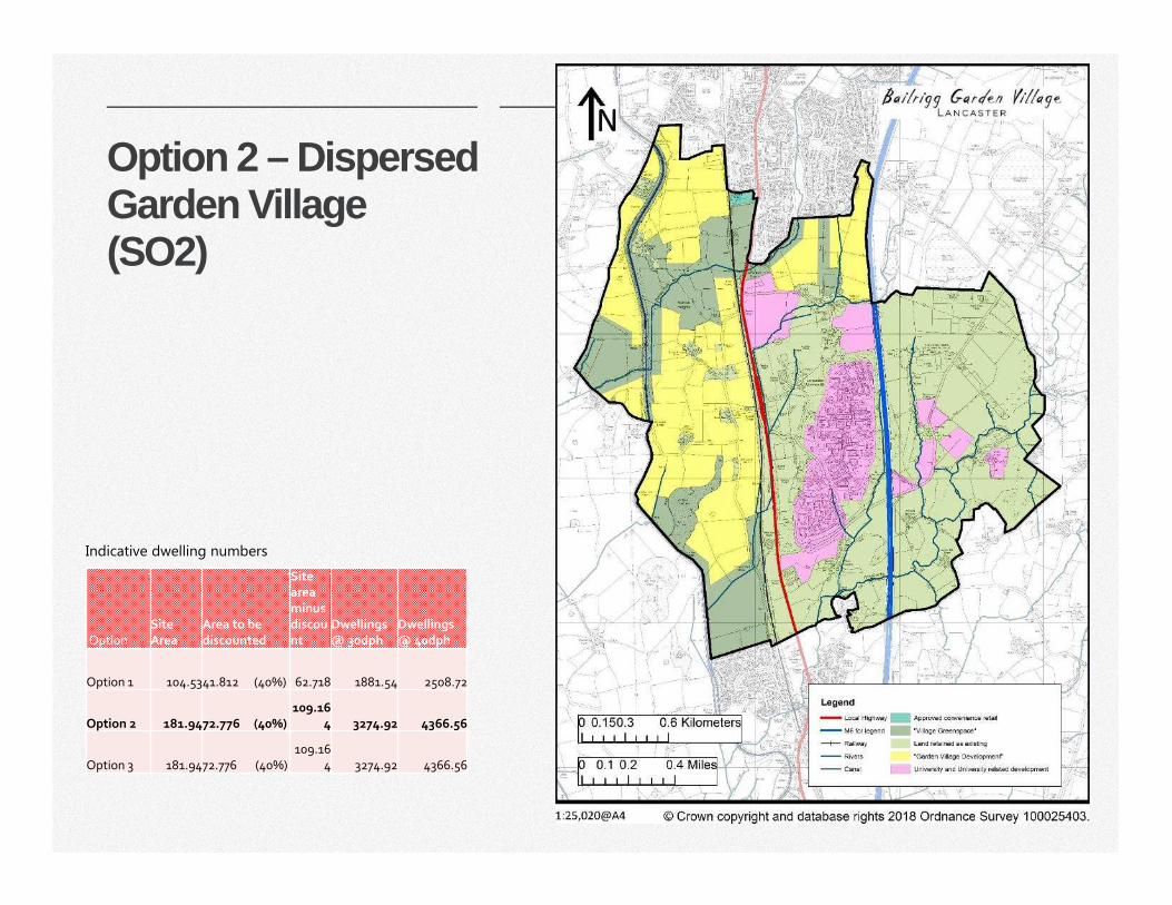
82|
Option 2 – Dispersed Garden Village (SO2)
Option
Site
Area
Area to be
discounted
Site
area
minus
discou
nt
Dwellings
@ 30dph
Dwellings
@ 40dph
Option 1 104.5341.812 (40%) 62.718 1881.54 2508.72
Option 2 181.9472.776 (40%)
109.16
4 3274.92 4366.56
Option 3 181.9472.776 (40%)
109.16
4 3274.92 4366.56
Indicative dwelling numbers
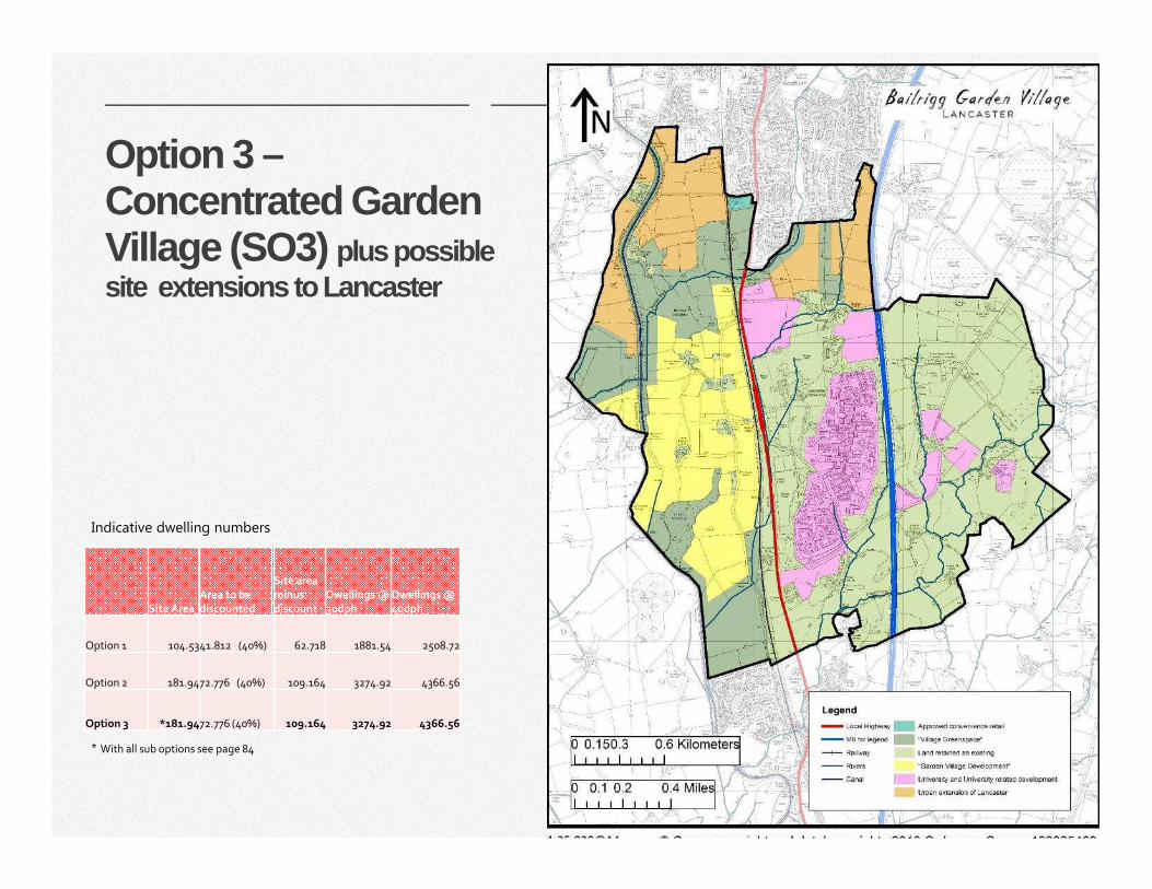
83|
Option 3 –Concentrated Garden Village (SO3) plus possible site extensions to Lancaster
Site Area Area to be discounted
Site area minus discount
Dwellings @ 30dph
Dwellings @ 40dph
Option 1 104.5341.812 (40%) 62.718 1881.54 2508.72
Option 2 181.9472.776 (40%) 109.164 3274.92 4366.56
Option 3 *181.9472.776 (40%) 109.164 3274.92 4366.56
* With all sub options see page 84
Indicative dwelling numbers
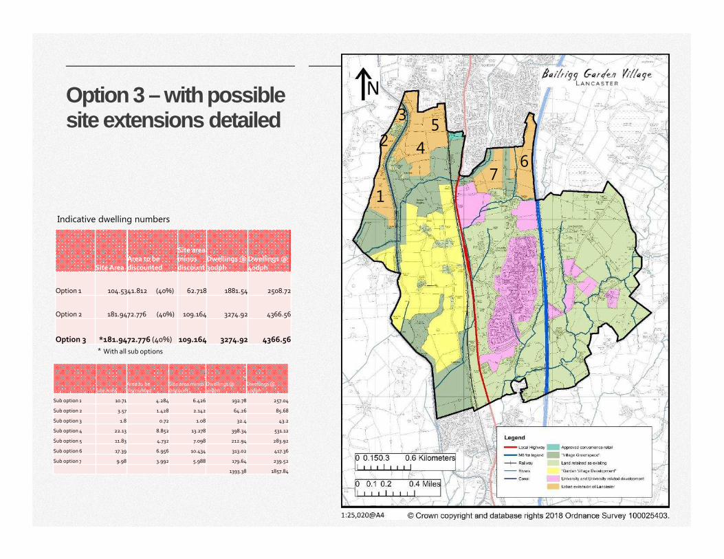
84|
Option 3 – with possible site extensions detailed
Site Area
Area to be
discounted
Site area minus
discount
Dwellings @
30dph
Dwellings @
4odph
Sub option 1 10.71 4.284 6.426 192.78 257.04
Sub option 2 3.57 1.428 2.142 64.26 85.68
Sub option 3 1.8 0.72 1.08 32.4 43.2
Sub option 4 22.13 8.852 13.278 398.34 531.12
Sub option 5 11.83 4.732 7.098 212.94 283.92
Sub option 6 17.39 6.956 10.434 313.02 417.36
Sub option 7 9.98 3.992 5.988 179.64 239.52
1393.38 1857.84
Site Area Area to be discounted
Site area minus discount
Dwellings @ 30dph
Dwellings @ 40dph
Option 1 104.5341.812 (40%) 62.718 1881.54 2508.72
Option 2 181.9472.776 (40%) 109.164 3274.92 4366.56
Option 3 *181.9472.776 (40%) 109.164 3274.92 4366.56
* With all sub options
Indicative dwelling numbers
1
2
3
4
5
76
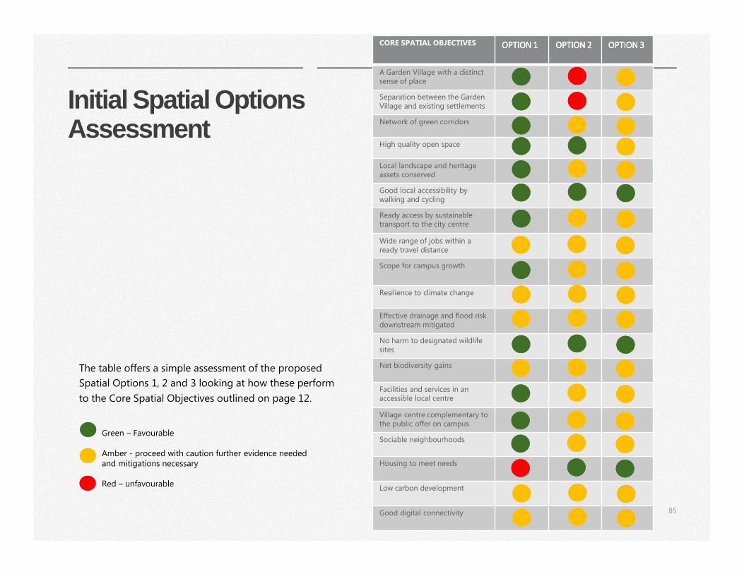
85|
Initial Spatial Options Assessment
The table offers a simple assessment of the proposed
Spatial Options 1, 2 and 3 looking at how these perform
to the Core Spatial Objectives outlined on page 12.
Green – Favourable
Amber - proceed with caution further evidence needed and mitigations necessary
Red – unfavourable
CORE SPATIAL OBJECTIVES OPTION 1OPTION 1OPTION 1OPTION 1 OPTION 2OPTION 2OPTION 2OPTION 2 OPTION 3OPTION 3OPTION 3OPTION 3
A Garden Village with a distinct sense of place
Separation between the Garden Village and existing settlements
Network of green corridors
High quality open space
Local landscape and heritage assets conserved
Good local accessibility by walking and cycling
Ready access by sustainable transport to the city centre
Wide range of jobs within a ready travel distance
Scope for campus growth
Resilience to climate change
Effective drainage and flood risk downstream mitigated
No harm to designated wildlife sites
Net biodiversity gains
Facilities and services in an accessible local centre
Village centre complementary to the public offer on campus
Sociable neighbourhoods
Housing to meet needs
Low carbon development
Good digital connectivity
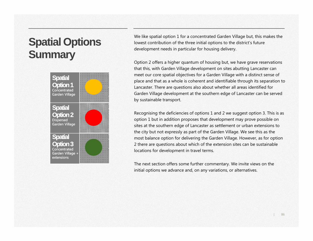
86|
Spatial Options Summary
We like spatial option 1 for a concentrated Garden Village but, this makes the
lowest contribution of the three initial options to the district’s future
development needs in particular for housing delivery.
Option 2 offers a higher quantum of housing but, we have grave reservations
that this, with Garden Village development on sites abutting Lancaster can
meet our core spatial objectives for a Garden Village with a distinct sense of
place and that as a whole is coherent and identifiable through its separation to
Lancaster. There are questions also about whether all areas identified for
Garden Village development at the southern edge of Lancaster can be served
by sustainable transport.
Recognising the deficiencies of options 1 and 2 we suggest option 3. This is as
option 1 but in addition proposes that development may prove possible on
sites at the southern edge of Lancaster as settlement or urban extensions to
the city but not expressly as part of the Garden Village. We see this as the
most balance option for delivering the Garden Village. However, as for option
2 there are questions about which of the extension sites can be sustainable
locations for development in travel terms.
The next section offers some further commentary. We invite views on the
initial options we advance and, on any variations, or alternatives.
Spatial Option 1 Concentrated Garden Village
Spatial Option 1 Concentrated Garden Village
Spatial Option 2 Dispersed Garden Village
Spatial Option 2 Dispersed Garden Village
Spatial Option 3 Concentrated Garden Village + extensions
Spatial Option 3 Concentrated Garden Village + extensions
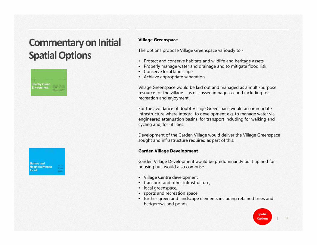
87|
Commentary on Initial
Spatial Options
Village Greenspace
The options propose Village Greenspace variously to -
• Protect and conserve habitats and wildlife and heritage assets • Properly manage water and drainage and to mitigate flood risk • Conserve local landscape• Achieve appropriate separation
Village Greenspace would be laid out and managed as a multi-purpose resource for the village – as discussed in page xxx and including for recreation and enjoyment.
For the avoidance of doubt Village Greenspace would accommodate infrastructure where integral to development e.g. to manage water via engineered attenuation basins, for transport including for walking and cycling and, for utilities.
Development of the Garden Village would deliver the Village Greenspace sought and infrastructure required as part of this.
Garden Village Development
Garden Village Development would be predominantly built up and for housing but, would also comprise -
• Village Centre development• transport and other infrastructure,• local greenspace, • sports and recreation space • further green and landscape elements including retained trees and
hedgerows and ponds
Spatial
Options
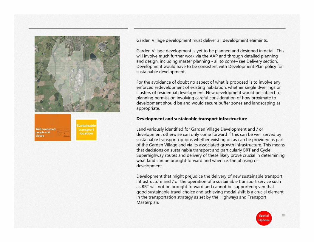
88|
Garden Village development must deliver all development elements.
Garden Village development is yet to be planned and designed in detail. This will involve much further work via the AAP and through detailed planning and design, including master planning - all to come– see Delivery section. Development would have to be consistent with Development Plan policy for sustainable development.
For the avoidance of doubt no aspect of what is proposed is to involve any enforced redevelopment of existing habitation, whether single dwellings or clusters of residential development. New development would be subject to planning permission involving careful consideration of how proximate to development should be and would secure buffer zones and landscaping as appropriate.
Development and sustainable transport infrastructure
Land variously identified for Garden Village Development and / or development otherwise can only come forward if this can be well served by sustainable transport options whether existing or, as can be provided as part of the Garden Village and via its associated growth infrastructure. This means that decisions on sustainable transport and particularly BRT and Cycle Superhighway routes and delivery of these likely prove crucial in determining what land can be brought forward and when i.e. the phasing of development.
Development that might prejudice the delivery of new sustainable transport infrastructure and / or the operation of a sustainable transport service such as BRT will not be brought forward and cannot be supported given that good sustainable travel choice and achieving modal shift is a crucial element in the transportation strategy as set by the Highways and Transport Masterplan.
Spatial
Options
Sustainable transport location
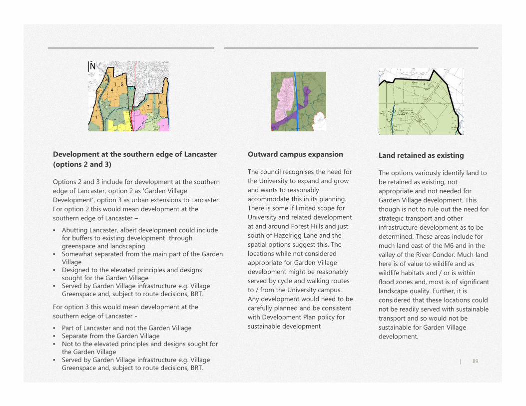
89|
Outward campus expansion
The council recognises the need for
the University to expand and grow
and wants to reasonably
accommodate this in its planning.
There is some if limited scope for
University and related development
at and around Forest Hills and just
south of Hazelrigg Lane and the
spatial options suggest this. The
locations while not considered
appropriate for Garden Village
development might be reasonably
served by cycle and walking routes
to / from the University campus.
Any development would need to be
carefully planned and be consistent
with Development Plan policy for
sustainable development
Land retained as existing
The options variously identify land to
be retained as existing, not
appropriate and not needed for
Garden Village development. This
though is not to rule out the need for
strategic transport and other
infrastructure development as to be
determined. These areas include for
much land east of the M6 and in the
valley of the River Conder. Much land
here is of value to wildlife and as
wildlife habitats and / or is within
flood zones and, most is of significant
landscape quality. Further, it is
considered that these locations could
not be readily served with sustainable
transport and so would not be
sustainable for Garden Village
development.
Development at the southern edge of Lancaster
(options 2 and 3)
Options 2 and 3 include for development at the southern
edge of Lancaster, option 2 as ‘Garden Village
Development’, option 3 as urban extensions to Lancaster.
For option 2 this would mean development at the
southern edge of Lancaster –
• Abutting Lancaster, albeit development could include for buffers to existing development through greenspace and landscaping
• Somewhat separated from the main part of the Garden Village
• Designed to the elevated principles and designs sought for the Garden Village
• Served by Garden Village infrastructure e.g. Village Greenspace and, subject to route decisions, BRT.
For option 3 this would mean development at the
southern edge of Lancaster -
• Part of Lancaster and not the Garden Village• Separate from the Garden Village• Not to the elevated principles and designs sought for
the Garden Village• Served by Garden Village infrastructure e.g. Village
Greenspace and, subject to route decisions, BRT.
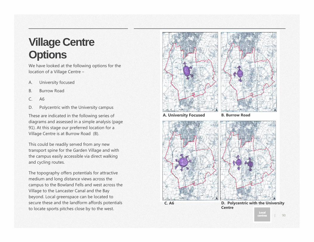
90|
Village Centre Options
A. University Focused B. Burrow Road
C. A6 D. Polycentric with the University Centre
Local centresLocal
centres
We have looked at the following options for the
location of a Village Centre –
A. University focused
B. Burrow Road
C. A6
D. Polycentric with the University campus
These are indicated in the following series of
diagrams and assessed in a simple analysis (page
91). At this stage our preferred location for a
Village Centre is at Burrow Road (B).
This could be readily served from any new
transport spine for the Garden Village and with
the campus easily accessible via direct walking
and cycling routes.
The topography offers potentials for attractive
medium and long distance views across the
campus to the Bowland Fells and west across the
Village to the Lancaster Canal and the Bay
beyond. Local greenspace can be located to
secure these and the landform affords potentials
to locate sports pitches close by to the west.
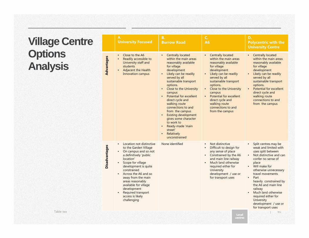
91|
Village Centre Options Analysis
Table xxx
A.
University Focused B. Burrow Road
C. A6
D. Polycentric with the University Centre
Ad
van
tag
es • Close to the A6
• Readily accessible to University staff and students
• Adjacent the Health Innovation campus
• Centrally located within the main areas reasonably available for village development
• Likely can be readily served by all sustainable transport options.
• Close to the University campus
• Potential for excellent direct cycle and walking route connections to and from the campus
• Existing development gives some character to work to
• Ready-made ‘main street’
• Relatively unconstrained
• Centrally located within the main areas reasonably available for village development
• Likely can be readily served by all sustainable transport options.
• Close to the University campus
• Potential for excellent direct cycle and walking route connections to and from the campus
• Centrally located within the main areas reasonably available for village development
• Likely can be readily served by all sustainable transport options.
• Potential for excellent direct cycle and walking route connections to and from the campus
Dis
ad
van
tag
es • Location not distinctive
to the Garden Village• On campus and so not
a definitively ‘public location’
• Scope for village development is quite constrained
• Across the A6 and so away from the main areas reasonably available for village development
• Required transport access is likely challenging
None identified • Not distinctive• Difficult to design for
any sense of place• Constrained by the A6
and main line railway• Much land otherwise
required either for University development / use or for transport uses
• Split centres may be weak and limited with uses split between
• Not distinctive and can confer no sense of place
• Will make for otherwise unnecessary travel movements
• Part heavily constrained by the A6 and main line railway
• Much land otherwise required either for University development / use or for transport uses
Local centresLocal
centres
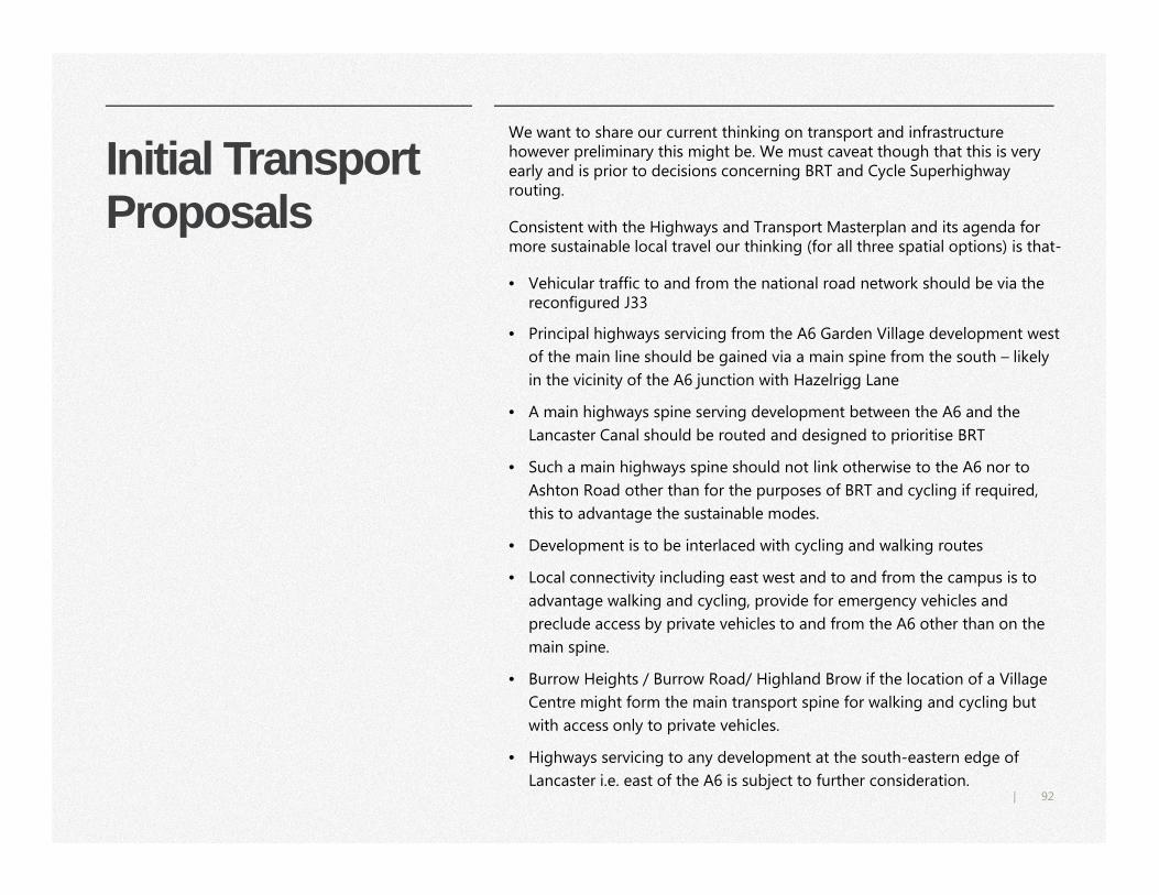
92|
Initial Transport Proposals
We want to share our current thinking on transport and infrastructure however preliminary this might be. We must caveat though that this is very early and is prior to decisions concerning BRT and Cycle Superhighway routing.
Consistent with the Highways and Transport Masterplan and its agenda for more sustainable local travel our thinking (for all three spatial options) is that-
• Vehicular traffic to and from the national road network should be via the reconfigured J33
• Principal highways servicing from the A6 Garden Village development west
of the main line should be gained via a main spine from the south – likely
in the vicinity of the A6 junction with Hazelrigg Lane
• A main highways spine serving development between the A6 and the
Lancaster Canal should be routed and designed to prioritise BRT
• Such a main highways spine should not link otherwise to the A6 nor to
Ashton Road other than for the purposes of BRT and cycling if required,
this to advantage the sustainable modes.
• Development is to be interlaced with cycling and walking routes
• Local connectivity including east west and to and from the campus is to
advantage walking and cycling, provide for emergency vehicles and
preclude access by private vehicles to and from the A6 other than on the
main spine.
• Burrow Heights / Burrow Road/ Highland Brow if the location of a Village
Centre might form the main transport spine for walking and cycling but
with access only to private vehicles.
• Highways servicing to any development at the south-eastern edge of
Lancaster i.e. east of the A6 is subject to further consideration.
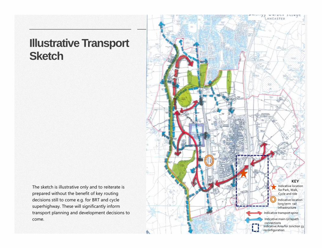
93|
Illustrative Transport Sketch
Indicative main cyclepath connections
Indicative transport spine
KEY
The sketch is illustrative only and to reiterate is
prepared without the benefit of key routing
decisions still to come e.g. for BRT and cycle
superhighway. These will significantly inform
transport planning and development decisions to
come.
Indicative Area for Junction 33 reconfiguration
Indicative location for Park, Walk, Cycle and ride
Indicative location long term rail infrastructure
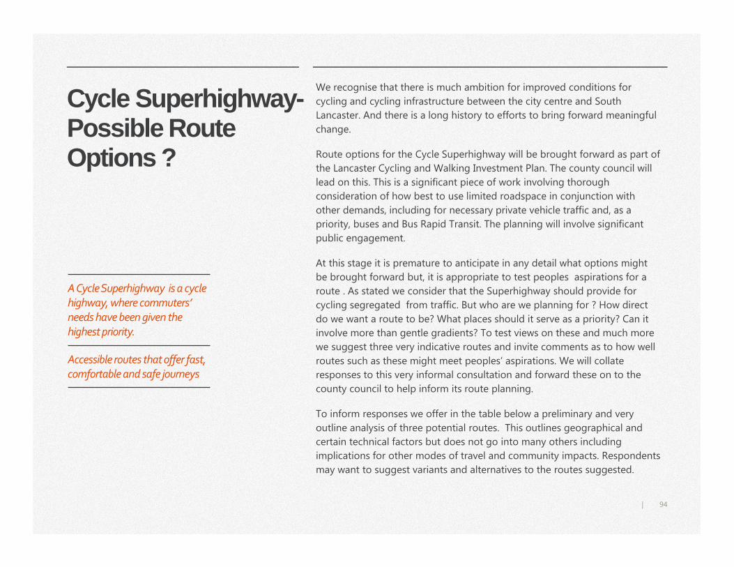
94|
Cycle Superhighway-Possible Route Options ?
We recognise that there is much ambition for improved conditions for
cycling and cycling infrastructure between the city centre and South
Lancaster. And there is a long history to efforts to bring forward meaningful
change.
Route options for the Cycle Superhighway will be brought forward as part of
the Lancaster Cycling and Walking Investment Plan. The county council will
lead on this. This is a significant piece of work involving thorough
consideration of how best to use limited roadspace in conjunction with
other demands, including for necessary private vehicle traffic and, as a
priority, buses and Bus Rapid Transit. The planning will involve significant
public engagement.
At this stage it is premature to anticipate in any detail what options might
be brought forward but, it is appropriate to test peoples aspirations for a
route . As stated we consider that the Superhighway should provide for
cycling segregated from traffic. But who are we planning for ? How direct
do we want a route to be? What places should it serve as a priority? Can it
involve more than gentle gradients? To test views on these and much more
we suggest three very indicative routes and invite comments as to how well
routes such as these might meet peoples’ aspirations. We will collate
responses to this very informal consultation and forward these on to the
county council to help inform its route planning.
To inform responses we offer in the table below a preliminary and very
outline analysis of three potential routes. This outlines geographical and
certain technical factors but does not go into many others including
implications for other modes of travel and community impacts. Respondents
may want to suggest variants and alternatives to the routes suggested.
A Cycle Superhighway is a cycle
highway, where commuters’
needs have been given the
highest priority.
Accessible routes that offer fast,
comfortable and safe journeys
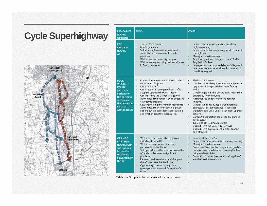
95|
Cycle Superhighway
Table xxx Simple initial analysis of route options
INDICATIVEROUTE OPTIONS
PROS CONS
RED CENTRAL ROUTEA6
• The most direct route • Gentle gradients• Sufficient highway capacity available -
subject to decisions on traffic mode priorities
• Well serves the University campus • Well serves large existing residential areas
in South Lancaster
• Requires the removal of most if not all on highway parking
• Requires extensive engineering works to adjust the highway
• Many junctions to redesign• Requires significant changes to (local) Traffic
Regulation Orders• Large parts of the proposed Garden Village will
be somewhat remote albeit ready connections could be designed
BLUE WESTERN ROUTE(with sub options for the northern section via the Lancaster canal or Ashton Road)
• Potential to achieve a full off road route if with Canal sub option
• Canal section is flat• Canal section is segregated from traffic• Scope to upgrade the Canal section• Can well serve the Garden Village well• Ashton Road sub option is quite direct and
with gentle gradients• Less engineering intervention required to
Ashton Road than for other on highway options but still some removal of parking and junction adjustments required.
• The least direct route.• Canal section will require significant engineering
upgrade including to achieve a satisfactory width.
• Canal bridges are a big obstacle and reduce the propensity for commuting.
• Alterations to bridges may have heritage impacts.
• Canal section already popular and potential conflicts with other users pedestrians/dog walkers/leisure users unless a sufficient upgrade achieve.
• Garden Village section can be readily planned but delivery
• subject to development progress• Doesn’t serve the University very well.• Doesn’t serve large residential areas connect
east of the A6
ORANGE EASTERN ROUTE (with sub options for northern section via bowerham or the a6)
• Well serves the University campus and including the new HIC
• Well serves large residential areas particularly east of the A6
• Sub option for northern section to use the A6 and avoid otherwise significant gradients.
• Requires less intervention and change to the A6 than does the Red Route
• Opportunity to route through Hala greenspace at Lentworth Drive/Whinfell Drive
• Less direct than the A6• Requires the removal of much highway parking• Many junctions to redesign• Bowerham Road involves a significant gradient
both ways and is a deterrent (to many) unless using an electric bike
• Sub option for a northern section along the A6 avoids this – but see above.
•
Lancaster University
Lancaster City Centre
Lancaster Canal
M6
Galgate
96|
Spatial Options
Do you have any further comments or suggestions to make on the initial spatial options or this section generally?
Q11 Which of the initial spatial options do you prefer? We present three options but we invite variations or alternative also.
Q13 Do you agree with our preferred Village Centre loca tion around Burrow Road? We see think its important to be in a readily accessible location with opportunity for character and identity.
Within these spatial options, do you agree with our proposed Village Greenspace? We see this as land that should be reserved from development, to help make a Healthy Green Environment.
Q12
Q16
Q14 Do you agree with our Initial Transport Proposals i ncluding indicative transport spine (pg.92-93) and any of the illustrat ive route options suggested for a Cycle Superhighway (pg. 94 -95)?
Do have any comments to make on the Draft Sustainab ility Appraisal (SA) of the Initial Spatial Options? The SA will test the emerging proposals for their contribution to sustainable development.
Q15
97|
Next and to come
The council intends to consult on
key issues and content options for
the Design Code this via a specific
round of engagement this
Summer.
Next, the council will consider
responses to the Issues and
Options Consultation and
engagement concerning the
engage Design Code and look to
prepare a preferred spatial option
for consultation hopefully this
autumn.
This document is about setting the
spatial and urban design framework
for development through the AAP,
about setting parameters for how we
are to achieve the Garden Village.
This may be viewed as the first stages
of master planning. The AAP will
direct and guide, a key element in
this will be an AAP Design Code.
The AAP will provide parameters and
direction for further masterplanning
and, in due course, for the
preparation of planning applications.
We will engage with landowners and developers and work cooperatively to
initiate and progress master planning consistent with the emerging AAP spatial
framework.
98|
Work to prepare Preferred Spatial Option and a Draft AAP
Work to prepare a preferred spatial option and Draft AAP will include inter alia to -
• Draft and engage on a Design Code
• Prepare a full Drainage and Flood Risk Strategy including to help mitigate flood risk to communities downstream
• Make full proposals to achieve net gains for biodiversity – to enhance habitats we safeguard and, to provide for wildlife as part of all development
• Determine what may be required to satisfactorily conserve habitat important to species associated with nearby internationally designated wildlife sites
• Confirm any requirements concerning minerals safeguarding
• Establish any requirements for noise attenuation
• Undertake appropriate archaeological assessments for the areas proposed for development
• Seek to establish the forward programme to reconfigure J33 (Lancashire County Council)
• Consult on BRT and cycling infrastructure (Lancashire County Council)
• Confirm the planned main transport and associated infrastructure (Lancashire County Council)
• Liaise with utilities and services providers and plan utilities provision
• Investigate further how best to plan for and assist business via development
• Confirm as far as possible health and education requirements of development
• Set expectations and local standards for sports and recreation provision
• Further engage with the Lancaster University
• Establish the feasibility of bespoke District Heating and any other energy technologies for the Garden Village
• Further engage with the Canals and Rivers Trust
• Determine land to be safeguarded for transport infrastructure
• Test development viability
• Explore with relevant organisations all reasonable options to secure land in appropriate management into the future
• Engage with landowners and farmers as appropriate concerning any implications for farming operations
• Investigate and propose development phasing
99|
Delivery The Area Action Plan will cover the delivery of growth and development but it is premature to cover this in any detail pending progress to determine infrastructure requirements and source funding. We need to get a good handle on this before work on viability and to establish priorities and, to determine phasing. The AAP will cover all these and more.
We aim at the preferred options stage to bring forward a credible and robust delivery plan grounded in a good understanding of constraints, opportunities and informed by sound infrastructure planning. To reiterate, significant growth and development at South Lancaster including for the Garden Village depends on providing substantial new infrastructure including J33 reconfiguration and for sustainable local transport and principally BRT.
To do this we will work closely with key partners notably the county council as transport infrastructure lead and with the University. We need also provide for the University’s reasonable growth ambitions as outlined to 2027 in its Masterplan and, beyond.
We will work with developers to understand viability issues and, to set a mechanism(s) for cost sharing / equalisation as appropriate. Necessarily for the Garden Village such a mechanism(s) will involve an element of land value capture and to a level likely greater than landowners would normally anticipate given substantial infrastructure requirements and elevated development and quality ambitions.
We anticipate making a Draft Delivery
Plan available as part of a preferred
options consultation.
It is for the Local Plan to bring forward
development at South Lancaster and
all development for the Garden Village
and University campus growth is
subject to planning permission
Good design takes time and delivering
quality development and a true
Garden Village will also take time.
100|
The traditional towns and cities that we love were not designed and built
over a few short decades. They were built one building at a time and then
allowed to evolve over centuries. They were often promoted by land owners
with a long-term interest in the success of the place and many of their
buildings were erected by people and businesses for their own use.
Olsen, Donald – Town Planning in London: The 18th an d 19th centuries – Yale University Press 1982
It is important to appreciate that development and growth at South Lancaster will take some years to achieve. This should not be read as a negative. It does take time to scope, plan, fund and provide significant new infrastructure. It takes time and much collaborative working to plan and bring forward quality development there are limits to the pace at which the private sector can deliver working within the supply and demand constraints of the contemporary housing market.
Development and growth at South Lancaster and the Garden Village are to make places for generations to come, and may prove the work of a generation.
We invite and look forward to receiving your comments on our thoughts so far.
101|
Background Evidence
DOCUMENT TITLE DOCUMENT LINK DATE
BAILRIGG GARDEN VILLAGE AREA ACTION PLAN ISSUES AND OPTIONS PAPER
https://www.lancaster.gov.uk/planning/planning-policy/bailrigg-garden-village
May-18
DRAFT SUSTAINABILITY APPRAISAL FOR INITIAL SPATIAL OPTIONS https://www.lancaster.gov.uk/planning/planning-policy/bailrigg-garden-village
May-18
PRELIMINARY COMMUNITY ENGAGEMENT AUTUMN 2017
www.lancaster.gov.uk/bgvevidence 2017
THE LOCAL VISON NARRATIVE www.lancaster.gov.uk/bgvevidence Jan-18
CONCEPT BAILRIGG FLOOD RISK AND DRAINAGE STRATEGY (JBA)
www.lancaster.gov.uk/bgvevidence Mar-18
GEO – ENVIRONMENTAL AND GROUNDWATER FLOODING DESK STUDY (JBA)
www.lancaster.gov.uk/bgvevidence Jan-18
CULVERT SURVEYS (JBA) www.lancaster.gov.uk/bgvevidence Oct-17
THE GARDEN VILLAGE PROSPECTUS www.lancaster.gov.uk/bgvevidence Dec-17
TOPIC PAPERS 1. www.lancaster.gov.uk/bgvevidence
BREEDING BIRDS SURVEYS OF LAND AROUND FOREST HILLS/HAZELRIGGG LANE LANCASTER UNDER CONSIDERATION FOR POTENTIAL FUTURE DEVELOPMENT (GMEU)
www.lancaster.gov.uk/bgvevidence Dec-17
PRELIMINARY ECOLOGICAL APPRAISALS SITES BEING CONSIDERED FOR ALLOCATION FOR FUTURE DEVELOPMENT (GMEU)
www.lancaster.gov.uk/bgvevidence Aug-17
LCC:STRATEGIC SITES LANDSCAPE & VISUAL ASSESSMENT PART 2.1: Site 01 - BAILRIGG GARDEN VILLAGE (ARCADIS)
www.lancaster.gov.uk/bgvevidence Apr-18
BAILRIGG GARDEN VILLAGE POSITION STATEMENT www.lancaster.gov.uk/bgvevidence
LANCASTER CITY COUNCIL -EXPRESSION OF INTEREST FOR A LOCALLY-LED GARDEN VILLAGE – BAILRIGG GARDEN VILLAGE, LANCASTER
www.lancaster.gov.uk/bgvevidence 2016
LANDSCAPE ASSESSMENT OF EMERGING SITE OPTIONS BAILRIGG, LANCASTER (WOOLERTON DODWELL)
http://www.lancaster.gov.uk/planning/planning-policy/environmental-studies
Nov-12
INITIAL DESKTOP ARCHAEOLOGICAL ASSESSMENT -(Assessments conducted by Lancashire Archaeological Advisory Service)
http://www.lancaster.gov.uk/planning/planning-policy/environmental-studies
Sept -2017 - Jan 18
102|
DOCUMENT TITLE DOCUMENT LINK DATE
LANCASHIRE STRATEGIC ECONOMIC PLAN – A Growth Deal for the Arc of Prosperity – Lancashire Enterprise Partnership
http://www.lancashirelep.co.uk/about-us/what-we-do/lancashire-strategic-economic-plan.aspx
Mar-14
THE LANCASTER DISTRICT LOCAL PLAN - Strategic Policies and Land Allocation Development Plan Document (DPD)
http://www.lancaster.gov.uk/planning/planning-policy/publication-local-plan
May-18
LANCASTER UNIVERSITY MASTERPLAN http://www.lancaster.ac.uk/facilities/about/masterplan/
2017
INFRASTRUCTURE DELIVERY PLAN, LANCASTER DISTRICT LOCAL PLAN
http://www.lancaster.gov.uk/planning/planning-policy/viability-studies
Feb-18
LANCASTER DISTRICT HIGHWAYS AND TRANSPORT MASTERPLAN (LANCASHIRE COUNTY COUNCIL)
http://www.lancashire.gov.uk/council/strategies-policies-plans/roads-parking-and-travel/highways-and-transport-masterplans/lancaster-district-highways-and-transport-masterplan
May-16
LANCASTER UNIVERSITY/BAILRIGG BUSINESS PARK DEVELOPMENT BRIEF SPG Note 5
http://www.lancaster.gov.uk/planning/planning-policy/supplementary-planning-documents-spds
Apr-02
EMPLOYMENT LAND SURVEY REPORT (LCC) http://www.lancaster.gov.uk/planning/planning-policy/employment-studies
SUMMER 2015
REVIEW OF THE EMP[LOYMENT LAND POSITION FOR LANCASTER DISTRICT (TURLEY)
2015
HOUSING STUDIES; HOUSING LAND MONITORING REPORTS, HOUSING LAND SUPPLY STATEMENT, STRATEGIC HOUSING AND EMPLOYMENT LAND AVAILABILITY ASSESSMENT
http://www.lancaster.gov.uk/planning/planning-policy/housing-reports-local-plan
VARIOUS
STRATEGIC HOUSING MARKET ASSESSMENT (ARC 4) 2018
LANCASTER DISTRICT ECONOMIC PROSPECTS: UPDATE REPORT (TURLEY)
http://www.lancaster.gov.uk/planning/planning-policy/employment-studies
Sep-17
STRATEGIC FLOOD RISK ASSESSMENT REPORT (SFRA) (JBA) http://www.lancaster.gov.uk/planning/planning-policy/environmental-studies
Oct-17
REVIEW STAGE 1: ASSESSMENT OF KEY URBAN LANDSCAPE REPORT (WOOLERTON DODWELL)
http://www.lancaster.gov.uk/planning/planning-policy/environmental-studies
Nov-12
REVIEW STAGE 2: EVALUATION OF KEY URBAN LANDSCAPES (WOOLERTON DODWELL)
http://www.lancaster.gov.uk/planning/planning-policy/environmental-studies
Nov-12
KEY URBAN LANDSCAPE REVIEW (ARCADIS) http://www.lancaster.gov.uk/planning/planning-policy/environmental-studies
Jul-05
LANDSCAPE, TOWNSCAPE AND VISUAL FIELD SUMMARY REPORT (LCC)
http://www.lancaster.gov.uk/planning/planning-policy/environmental-studies
Mar-16
PRELIMINARY DESK TOP ECOLOGICAL ASSESSMENTS -LANCASTER CITY COUNCIL POTENTIAL ALLOCATED SITES
http://www.lancaster.gov.uk/planning/planning-policy/environmental-studies
Mar-17
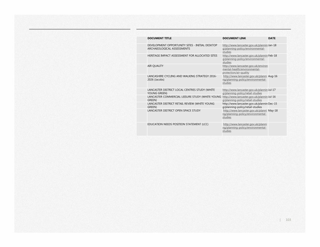
103|
DOCUMENT TITLE DOCUMENT LINK DATE
DEVELOPMENT OPPORTUNITY SITES - INITIAL DESKTOP ARCHAEOLOGICAL ASSESSMENTS
http://www.lancaster.gov.uk/planning/planning-policy/environmental-studies
Jan-18
HERITAGE IMPACT ASSESSMENT FOR ALLOCATED SITES http://www.lancaster.gov.uk/planning/planning-policy/environmental-studies
Feb-18
AIR QUALITY http://www.lancaster.gov.uk/environmental-health/environmental-protection/air-quality
LANCASHIRE CYCLING AND WALKING STRATEGY 2016-2026 (Jacobs)
http://www.lancaster.gov.uk/planning/planning-policy/environmental-studies
Aug-16
LANCASTER DISTRICT LOCAL CENTRES STUDY (WHITE YOUNG GREEN)
http://www.lancaster.gov.uk/planning/planning-policy/retail-studies
Jul-17
LANCASTER COMMERCIAL LEISURE STUDY (WHITE YOUNG GREEN)
http://www.lancaster.gov.uk/planning/planning-policy/retail-studies
Jul-16
LANCASTER DISTRICT RETAIL REVIEW (WHITE YOUNG GREEN)
http://www.lancaster.gov.uk/planning/planning-policy/retail-studies
Dec-15
LANCASTER DISTRICT OPEN SPACE STUDY http://www.lancaster.gov.uk/planning/planning-policy/environmental-studies
May-18
EDUCATION NEEDS POSITION STATEMENT (LCC) http://www.lancaster.gov.uk/planning/planning-policy/environmental-studies