Embed Size (px)
Citation preview
Unclassified
Land Information Ontario Data Description
Bait Harvest Area Disclaimer This technical documentation has been prepared by the Ministry of Natural Resources (the “Ministry”), representing Her Majesty the Queen in right of Ontario. Although every effort has been made to verify the information, this document is presented as is, and the Ministry makes no guarantees, representations or warranties with respect to the information contained within this document, either express or implied, arising by law or otherwise, including but not limited to, effectiveness, completeness, accuracy, or fitness for purpose. The Ministry is not liable or responsible for any loss or harm of any kind arising from use of this information. Some of the information in this document is nonconvertible or has not yet been made accessible and may not be compatible with assistive technologies. If you need any of the information in an alternate format, please contact LIO Support at [email protected] or (705) 755-1878.
©Queens Printer for Ontario, 2012
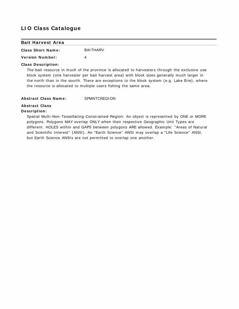
LIO Class Catalogue Bait Harvest Area
Class Short Name:
Version Number:
Class Description:
BAITHARV 4
The bait resource in much of the province is allocated to harvesters through the exclusive use block system (one harvester per bait harvest area) with block sizes generally much larger in the north than in the sourth. There are exceptions to the block system (e.g. Lake Erie), where the resource is allocated to multiple users fishing the same area.
Abstract Class Name:
Abstract Class Description:
SPMNTCREGION
Spatial Multi-Non-Tessellating-Constrained-Region: An object is represented by ONE or MORE polygons. Polygons MAY overlap ONLY when their respective Geographic Unit Types are different. HOLES within and GAPS between polygons ARE allowed. Example: "Areas of Natural and Scientific Interest" (ANSI). An "Earth Science" ANSI may overlap a "Life Science" ANSI, but Earth Science ANSIs are not permitted to overlap one another.
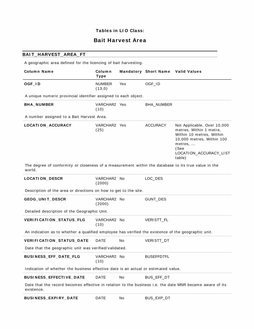
Tables in LIO Class:
Bait Harvest Area BAIT_HARVEST_AREA_FT
A geographic area defined for the licencing of bait harvesting.
Column Name Column Type
Mandatory Short Name Valid Values
OGF_ID NUMBER
(13,0)
Yes OGF_ID
A unique numeric provincial identifier assigned to each object.
BHA_NUMBER VARCHAR2 (10)
A number assigned to a Bait Harvest Area.
LOCATION_ACCURACY VARCHAR2 (25)
Yes BHA_NUMBER Yes ACCURACY Not Applicable, Over 10,000
metres, Within 1 metre, Within 10 metres, Within 10,000 metres, Within 100 metres, ... (See LOCATION_ACCURACY_LIST table)
The degree of conformity or closeness of a measurement within the database to its true value in the world.
LOCATION_DESCR VARCHAR2 (2000)
No LOC_DES
Description of the area or directions on how to get to the site.
GEOG_UNIT_DESCR VARCHAR2 (2000)
Detailed description of the Geographic Unit.
VERIFICATION_STATUS_FLG VARCHAR2 (10)
No GUNT_DES No VERISTT_FL
An indication as to whether a qualified employee has verified the existence of the geographic unit.
VERIFICATION_STATUS_DATE DATE No VERISTT_DT
Date that the geographic unit was verified/validated.
BUSINESS_EFF_DATE_FLG VARCHAR2 (10)
No BUSEFFDTFL
Indication of whether the business effective date is an actual or estimated value.
BUSINESS_EFFECTIVE_DATE DATE No BUS_EFF_DT
Date that the record becomes effective in relation to the business i.e. the date MNR became aware of its existence.
BUSINESS_EXPIRY_DATE DATE No BUS_EXP_DT
A date indicating when the record was determined to be invalid.
SYSTEM_CALCULATED_AREA NUMBER (16,3)
No SYS_AREA
The area of a polygon measured in square metres by the system.
SYSTEM_CALCULATED_LENGTH NUMBER (16,3)
No SYS_LENGTH
The perimeter of a polygon or length of a line measured in metres.
USER_CALCULATED_METRIC NUMBER (16,3)
No USER_CALC
The length, perimeter or area of an object in metres or square metres as measured or provided by the user.
GENERAL_COMMENTS VARCHAR2 (2000)
No GNL_CMT
General comments.
GEOMETRY_UPDATE_DATETIME DATE No GEO_UPD_DT
Date/time the geometry was created or last modified in the source database.
EFFECTIVE_DATETIME DATE Yes EFF_DATE
Date/time the record was created or last modified in the source database. BAIT_ANNUAL_EXPORT
The annual amount of bait that was exported.
Column Name Column Type
Mandatory Short Name Valid Values
BAIT_LICENCE_ID NUMBER (13,0)
Yes BT_LIC_OID
Foreign key to BAIT LICENCE
EXPORT_YEAR NUMBER (4,0)
Yes EXP_YEAR
The year that the bait export summary details are associated to.
BAIT_TYPE VARCHAR2 (20)
Yes BAIT_TYPE Bait-fish, Emerald Shiners, Lake Herring, Leeches (See BAIT_TYPE_LIST table)
This field identifies the specific type of bait e.g. Bait-fish, Emerald Shiners, Lake Herring, Leeches.
EXPORT_QUANTITY NUMBER (10,2)
Yes EXP_QUAN
This is the quantity of a specific bait type exported during the year measured in pounds, dozens or gallons. The unit of measure applicable to the value stored in this field is identified in the UNIT_OF_MEASURE field.
UNIT_OF_MEASURE VARCHAR2 (10)
Yes UNT_MSR
The Unit of Measure used to quantify the bait export quantity measured in dozens, gallons or
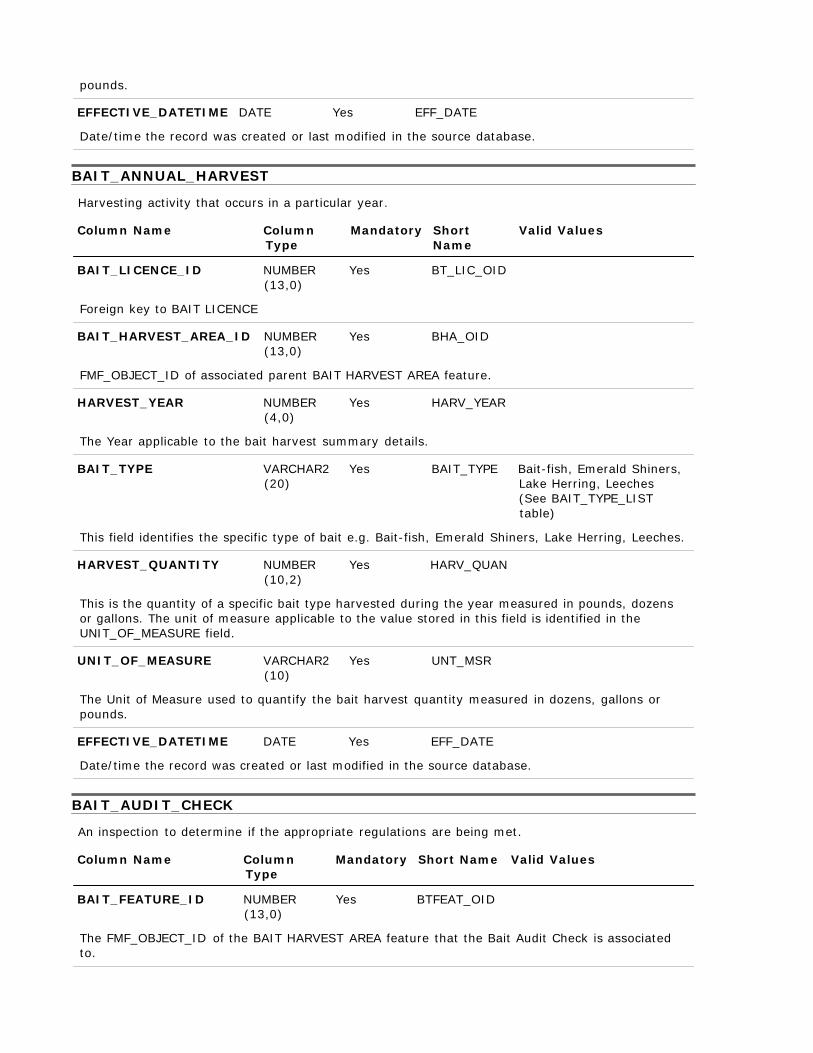
pounds.
EFFECTIVE_DATETIME DATE Yes EFF_DATE
Date/time the record was created or last modified in the source database. BAIT_ANNUAL_HARVEST
Harvesting activity that occurs in a particular year.
Column Name Column Type
Mandatory Short Name
Valid Values
BAIT_LICENCE_ID NUMBER
(13,0)
Yes BT_LIC_OID
Foreign key to BAIT LICENCE
BAIT_HARVEST_AREA_ID NUMBER (13,0)
Yes BHA_OID
FMF_OBJECT_ID of associated parent BAIT HARVEST AREA feature.
HARVEST_YEAR NUMBER (4,0)
Yes HARV_YEAR
The Year applicable to the bait harvest summary details.
BAIT_TYPE VARCHAR2 (20)
Yes BAIT_TYPE Bait-fish, Emerald Shiners, Lake Herring, Leeches (See BAIT_TYPE_LIST table)
This field identifies the specific type of bait e.g. Bait-fish, Emerald Shiners, Lake Herring, Leeches.
HARVEST_QUANTITY NUMBER
(10,2) Yes HARV_QUAN
This is the quantity of a specific bait type harvested during the year measured in pounds, dozens or gallons. The unit of measure applicable to the value stored in this field is identified in the UNIT_OF_MEASURE field.
UNIT_OF_MEASURE VARCHAR2 (10)
Yes UNT_MSR
The Unit of Measure used to quantify the bait harvest quantity measured in dozens, gallons or pounds.
EFFECTIVE_DATETIME DATE Yes EFF_DATE
Date/time the record was created or last modified in the source database. BAIT_AUDIT_CHECK
An inspection to determine if the appropriate regulations are being met.
Column Name Column Type
Mandatory Short Name Valid Values
BAIT_FEATURE_ID NUMBER
(13,0)
Yes BTFEAT_OID
The FMF_OBJECT_ID of the BAIT HARVEST AREA feature that the Bait Audit Check is associated to.
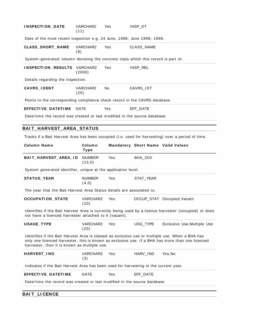
INSPECTION_DATE VARCHAR2 (11)
Yes INSP_DT
Date of the most recent inspection e.g. 24 June, 1998; June 1998; 1998.
CLASS_SHORT_NAME VARCHAR2 (8)
Yes CLASS_NAME
System-generated column denoting the concrete class which this record is part of.
INSPECTION_RESULTS VARCHAR2 (2000)
Details regarding the inspection.
CAVRS_IDENT VARCHAR2 (20)
Yes INSP_REL No CAVRS_IDT
Points to the corresponding compliance check record in the CAVRS database.
EFFECTIVE_DATETIME DATE Yes EFF_DATE
Date/time the record was created or last modified in the source database. BAIT_HARVEST_AREA_STATUS
Tracks if a Bait Harvest Area has been occupied (i.e. used for harvesting) over a period of time.
Column Name Column Type
Mandatory Short Name Valid Values
BAIT_HARVEST_AREA_ID NUMBER
(13,0)
Yes BHA_OID
System generated identifier, unique at the application level.
STATUS_YEAR NUMBER (4,0)
Yes STAT_YEAR
The year that the Bait Harvest Area Status details are associated to.
OCCUPATION_STATE VARCHAR2 (10)
Yes OCCUP_STAT Occupied,Vacant
Identifies if the Bait Harvest Area is currently being used by a licence harvester (occupied) or does not have a licenced harvester attached to it (vacant).
USAGE_TYPE VARCHAR2 (20)
Yes USG_TYPE Exclusive Use,Multiple Use
Identifies if the Bait Harvest Area is classed as exclusive use or multiple use. When a BHA has only one licenced harvester, this is known as exclusive use. If a BHA has more than one licenced harvester, then it is known as multiple use.
HARVEST_IND VARCHAR2 (3)
Yes HARV_IND Yes,No
Indicates if the Bait Harvest Area has been used for harvesting in the current year.
EFFECTIVE_DATETIME DATE Yes EFF_DATE
Date/time the record was created or last modified in the source database. BAIT_LICENCE
Authorization to either harvest and/or deal in bait.
Column Name Column Type
Mandatory Short Name
Valid Values
OGF_ID NUMBER (13,0)
Yes OGF_ID
A unique numeric provincial identifier assigned to each object.
LICENCE_TYPE_FLG VARCHAR2 (10)
Yes LIC_TYPE Harvester, Dealer
The type of bait licence issued to the applicant, whether as a Harvester or Dealer.
LICENCE_NUMBER VARCHAR2 (10)
Yes LIC_NUM
The licence number assigned to the person who has rights to harvest and/or deal bait.
LICENCE_NUMBER_PROV VARCHAR2 (10)
Yes LIC_NUM_PR
The provincial licence number assigned to the person who has rights to harvest and/or deal bait.
LICENCE_CONDITIONS VARCHAR2 (2000)
No LIC_COND
Identifies any limits or qualifiers that may be attached to a licence.
LICENCE_FEE VARCHAR2 (10)
No LIC_FEE
The amount of money collected for a specific licence.
REVENUE_CODE VARCHAR2 (20)
Yes REVENUE_C
The general ledger revenue code to which the licensing fee is assigned.
LICENCE_EFFECTIVE_DATE DATE Yes LIC_EFF_DT
The date when the licence becomes effective.
LICENCE_ISSUED_DATE DATE Yes LIC_ISS_DT
Date the licence was issued.
ISSUING_DISTRICT VARCHAR2 (50)
Yes ISSU_DIST
The Ministry of Natural Resources district which issued the licence. The licence may be issued by a district other than where the BHA is located in.
RECEIPT_NUMBER VARCHAR2 (25)
No RECEIPT_NM
The identification number on the receipt provided to the purchaser of the licence.
HARVESTER_TYPE_FLG VARCHAR2 (10)
No HARV_TYPE Regular, Tourist
Identifies whether the licenced harvester is a Regular or Tourist to the operation.
HARVEST_BAITFISH_IND VARCHAR2 (3)
No BAITFISH Yes,No

Indicates whether this licence allows the harvesting of baitfish.
HARVEST_LEECHES_IND VARCHAR2 (3)
No LEECHES Yes,No
Indicates whether this licence allows the harvesting of leeches.
DEALER_TYPE_FLG VARCHAR2 (10)
No DLR_TP_FLG Regular, Tourist
Identifies whether the licenced bait dealer is a Regular or Tourist to the operation.
EFFECTIVE_DATETIME DATE Yes EFF_DATE
Date/time the record was created or last modified in the source database. BAIT_LICENCE_AND_AREA
Intersect Table between BAIT HARVEST AREA and BAIT LICENCE.
Column Name Column Type
Mandatory Short Name
Valid Values
BAIT_LICENCE_ID NUMBER
(13,0)
Yes BT_LIC_OID
Foreign key to BAIT LICENCE
BAIT_HARVEST_AREA_ID NUMBER (13,0)
Yes BHA_OID
FMF_OBJECT_ID of associated parent BAIT HARVEST AREA feature.
EFFECTIVE_DATETIME DATE Yes EFF_DATE
Date/time the record was created or last modified in the source database. BAIT_LICENCE_HARVEST_GEAR
Equipment used by a licenced person to capture bait. For example: trap, seine, etc.
Column Name Column Type
Mandatory Short Name
Valid Values
BAIT_LICENCE_ID NUMBER (13,0)
Yes BT_LIC_OID
Foreign key to the parent BAIT_LICENCE record FMF_OBJECT_ID
BAIT_HARVEST_GEAR_TYPE VARCHAR2 (20)
Yes TYPE
Identifies the type of fishing gear used to harvest bait e.g. trap, seine etc.
EFFECTIVE_DATETIME DATE Yes EFF_DATE
Date/time the record was created or last modified in the source database. BAIT_MONTHLY_SALES
The activity, either harvesting and/or sales, that occurs in a given month.
Column Name Column Type
Mandatory Short Name Valid Values

BAIT_LICENCE_ID NUMBER (13,0)
Yes BT_LIC_OID
Foreign key to the parent BAIT_LICENCE record FMF_OBJECT_ID
SALES_YEAR NUMBER (4,0)
Yes SALES_YEAR
The year that the Bait Monthly Sales summary pertains to.
SALES_MONTH VARCHAR2 (15)
Yes SALES_MNTH
The month that the Bait Monthly Sales summary pertains to.
BAIT_TYPE VARCHAR2 (20)
Yes BAIT_TYPE Bait-fish, Emerald Shiners, Lake Herring, Leeches (See BAIT_TYPE_LIST table)
This field identifies the specific type of bait e.g. Bait-fish, Emerald Shiners, Lake Herring, Leeches.
SALES_QUANTITY NUMBER (10,2)
Yes SALES_QUAN
This is the quantity of a specific bait type sold during the year measured in pounds, dozens or gallons. The unit of measure applicable to the value stored in this field is identified in the UNIT_OF_MEASURE field.
UNIT_OF_MEASURE VARCHAR2 (10)
Yes UNT_MSR
The Unit of Measure used to quantify the bait sales quantity measured in dozens, gallons or pounds.
DOLLAR_VALUE NUMBER (10,2)
No DOLLAR_VAL
The dollar value (CAD) generated from sales for a specific month and bait type.
EFFECTIVE_DATETIME DATE Yes EFF_DATE
Date/time the record was created or last modified in the source database. BAIT_TYPE_LIST
This Lookup Table stores the permissible values for bait types e.g. Bait-fish, Emerald Shiners, Lake Herring, Leeches.
Column Name Column
Type Mandatory Short Name Valid Values
BAIT_TYPE VARCHAR2
(20)
Yes BAIT_TYPE
This field identifies the specific type of bait e.g. Bait-fish, Emerald Shiners, Lake Herring, Leeches.
WILD_LIFE_ID NUMBER (38,0)
No WILDLIFEID
An ID pointing to a corporate list of taxa.
EFFECTIVE_DATETIME DATE Yes EFF_DATE
Date/time the record was created or last modified in the source database.
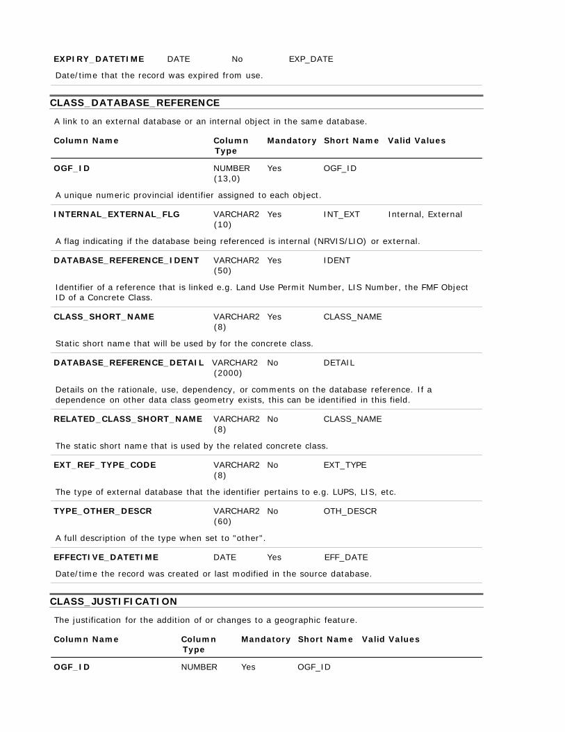
EXPIRY_DATETIME DATE No EXP_DATE
Date/time that the record was expired from use. CLASS_DATABASE_REFERENCE
A link to an external database or an internal object in the same database.
Column Name Column Type
Mandatory Short Name Valid Values
OGF_ID NUMBER
(13,0)
Yes OGF_ID
A unique numeric provincial identifier assigned to each object.
INTERNAL_EXTERNAL_FLG VARCHAR2 (10)
Yes INT_EXT Internal, External
A flag indicating if the database being referenced is internal (NRVIS/LIO) or external.
DATABASE_REFERENCE_IDENT VARCHAR2 (50)
Yes IDENT
Identifier of a reference that is linked e.g. Land Use Permit Number, LIS Number, the FMF Object ID of a Concrete Class.
CLASS_SHORT_NAME VARCHAR2
(8) Yes CLASS_NAME
Static short name that will be used by for the concrete class.
DATABASE_REFERENCE_DETAIL VARCHAR2 (2000)
No DETAIL
Details on the rationale, use, dependency, or comments on the database reference. If a dependence on other data class geometry exists, this can be identified in this field.
RELATED_CLASS_SHORT_NAME VARCHAR2 (8)
No CLASS_NAME
The static short name that is used by the related concrete class.
EXT_REF_TYPE_CODE VARCHAR2 (8)
No EXT_TYPE
The type of external database that the identifier pertains to e.g. LUPS, LIS, etc.
TYPE_OTHER_DESCR VARCHAR2 (60)
A full description of the type when set to "other".
No OTH_DESCR
EFFECTIVE_DATETIME DATE Yes EFF_DATE
Date/time the record was created or last modified in the source database.
CLASS_JUSTIFICATION
The justification for the addition of or changes to a geographic feature.
Column Name Column Type
Mandatory Short Name Valid Values
OGF_ID NUMBER Yes OGF_ID
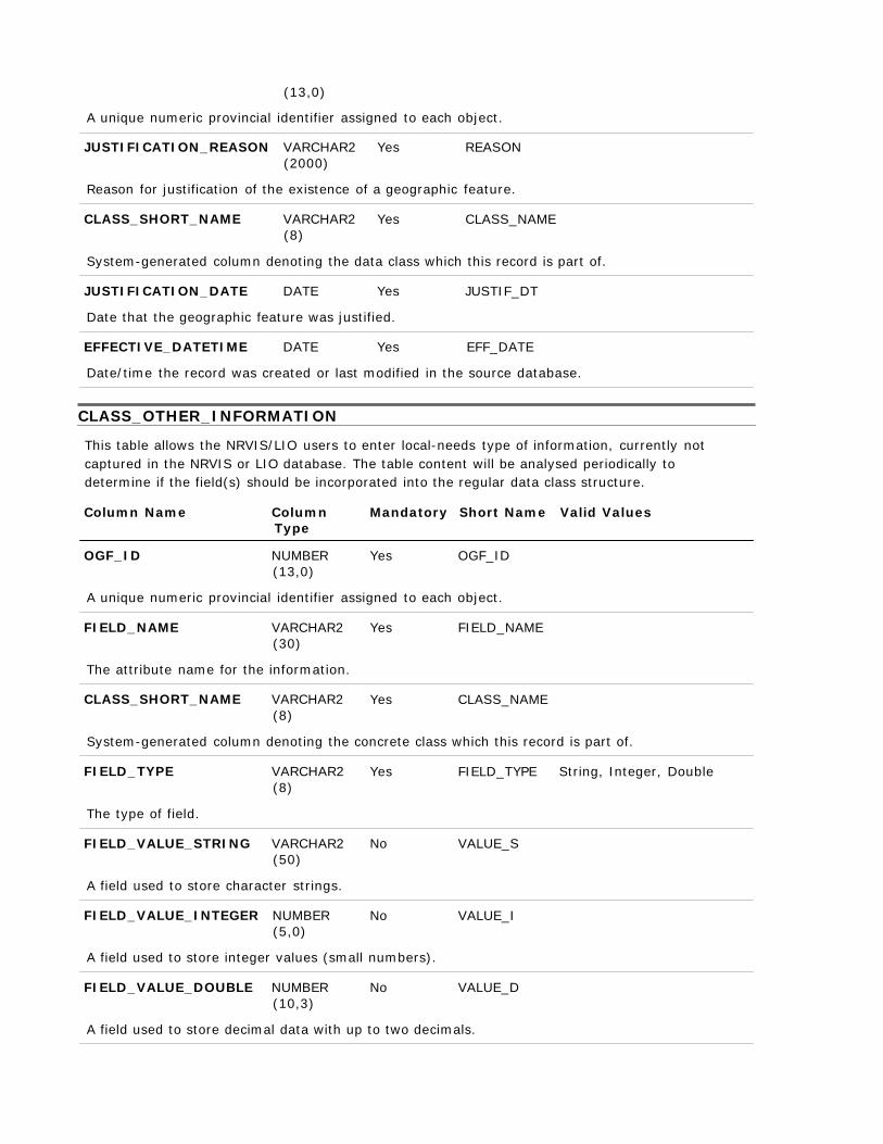
(13,0)
A unique numeric provincial identifier assigned to each object.
JUSTIFICATION_REASON VARCHAR2 (2000)
Yes REASON
Reason for justification of the existence of a geographic feature.
CLASS_SHORT_NAME VARCHAR2 (8)
Yes CLASS_NAME
System-generated column denoting the data class which this record is part of.
JUSTIFICATION_DATE DATE Yes JUSTIF_DT
Date that the geographic feature was justified.
EFFECTIVE_DATETIME DATE Yes EFF_DATE
Date/time the record was created or last modified in the source database. CLASS_OTHER_INFORMATION
This table allows the NRVIS/LIO users to enter local-needs type of information, currently not captured in the NRVIS or LIO database. The table content will be analysed periodically to determine if the field(s) should be incorporated into the regular data class structure.
Column Name Column
Type Mandatory Short Name Valid Values
OGF_ID NUMBER
(13,0)
Yes OGF_ID
A unique numeric provincial identifier assigned to each object.
FIELD_NAME VARCHAR2 (30)
The attribute name for the information.
CLASS_SHORT_NAME VARCHAR2 (8)
Yes FIELD_NAME Yes CLASS_NAME
System-generated column denoting the concrete class which this record is part of.
FIELD_TYPE VARCHAR2 (8)
Yes FIELD_TYPE String, Integer, Double
The type of field.
FIELD_VALUE_STRING VARCHAR2 (50)
A field used to store character strings.
FIELD_VALUE_INTEGER NUMBER (5,0)
No VALUE_S No VALUE_I
A field used to store integer values (small numbers).
FIELD_VALUE_DOUBLE NUMBER (10,3)
No VALUE_D
A field used to store decimal data with up to two decimals.

EFFECTIVE_DATETIME DATE Yes EFF_DATE
Date/time the record was created or last modified in the source database. CLASS_PARTY_ROLE
A link to an external contact database.
Column Name Column Type
Mandatory Short Name Valid Values
OGF_ID NUMBER
(13,0)
Yes OGF_ID
A unique numeric provincial identifier assigned to each object.
PARTY_IDENT VARCHAR2 (25)
Yes PARTY_ID
An identifier for a party (group or individual). It should reference an identifier in an external database which would contain further information. The identifier should not contain personal information (i.e. Social Insurance Number, Outdoors Card Number, phone number, name etc.).
PARTY_DATABASE VARCHAR2 (100)
Yes PARTY_DB
The database that contains the party information.
ROLE_TYPE VARCHAR2 (50)
Yes ROLE_TYPE Affiliated With, Approver, Authority Holder, Claim Holder, Contact, Contractor, ... (See ROLE_TYPE_LIST table)
The role that an organization or an individual plays.
CLASS_SHORT_NAME VARCHAR2 (8)
Yes CLASS_NAME
System-generated column denoting the concrete class which this record is part of.
ROLE_DETAIL VARCHAR2 (200)
Additional details about the role.
No DETAIL
START_DATE DATE No START_DATE
The date when a Party starts to play a Role.
END_DATE DATE No END_DATE
The date when a Party ceases to play a Role.
EFFECTIVE_DATETIME DATE Yes EFF_DATE
Date/time the record was created or last modified in the source database. CLASS_SOURCE
Intersection table between the data class and Source List table.
Column Name Column Type
Mandatory Short Name Valid Values

OGF_ID NUMBER (13,0)
Yes OGF_ID
A unique numeric provincial identifier assigned to each object.
SOURCE_NAME VARCHAR2 (100)
Yes SOURCE_NAM AFFM Provincial Administrative Maps, Aerial Photography, Aerial Survey, Book/Publication, CIR Photograpy, City of Ottawa Borehole Database, ... (See SOURCE_LIST table)
The name of the source.
SOURCE_DETAIL VARCHAR2 (254)
Yes SOURCE_DET
What part of the source pertains to the feature. Examples: Summary data from a data base, pages in a book or atlas, figure number and page from a publication, a section of a map, record in a database.
CLASS_SHORT_NAME VARCHAR2 (8)
Yes CLASS_NAME
Unique abbreviation of the concrete class name (primary key)
SOURCE_DESCR VARCHAR2 (2000)
Text providing details about the source.
METHOD_DESCR VARCHAR2 (2000)
No SOURCE_DES No METHOD
The type of method, tools, and techniques used in observing/collecting/recording the Source. It may also include a URL where users could get further information on the method used.
SOURCE_APPLICABILITY VARCHAR2 (20)
No APPLICABIL
How the source contributes to the feature's definition.
EFFECTIVE_DATETIME DATE Yes EFF_DATE
Date/time the record was created or last modified in the source database. CLASS_SUPPORTING_MATERIAL
Material (document/file/picture) that provides more information on a geographic feature.
Column Name Column Type
Mandatory Short Name Valid Values
OGF_ID NUMBER
(13,0)
Yes OGF_ID
A unique numeric provincial identifier assigned to each object.
MATERIAL_NAME VARCHAR2 (200)
Yes NAME
A name or brief description of the material.

MATERIAL_LOCATION VARCHAR2 (200)
Yes LOCATION
The location where the supporting material is stored. This may be a physical location or a link to a storage location.
CLASS_SHORT_NAME VARCHAR2 (8)
Yes CLASS_NAME
System-generated column denoting the concrete class which this record is part of.
URL_ENG VARCHAR2 (500)
No URL_ENG
The address of a computer or a document in English on the Internet that consists of a communications protocol followed by a colon and two slashes (as http://), the identifier of a computer (as www.m-w.com) and usually a path through a directory to a file -- called also universal resource locator.
URL_FRE VARCHAR2 (500)
No URL_FRE
The address of a computer or a document in French on the Internet that consists of a communications protocol followed by a colon and two slashes (as http://), the identifier of a computer (as www.m-w.com) and usually a path through a directory to a file -- called also universal resource locator.
EFFECTIVE_DATETIME DATE Yes EFF_DATE
Date/time the record was created or last modified in the source database. EXTERNAL_REF_TYPE_LIST
List of valid EXTERNAL_REFERENCE_TYPE codes.
Column Name Column Type
Mandatory Short Name Valid Values
EXT_REF_TYPE_CODE VARCHAR2
(8)
Yes EXT_REF_TY
The type of external database that the identifier pertains to e.g. LUPS, LIS, Other.
EXT_REF_TYPE_DESCR VARCHAR2 (60)
Yes EXT_REF_TY
Description of the type of external reference.
EFFECTIVE_DATETIME DATE Yes EFF_DATE
Date/time the record was created or last modified in the source database.
EXPIRY_DATETIME DATE No EXP_DATE
Date/time that the record was expired from use. LOCATION_ACCURACY_LIST
List of valid LOCATION_ACCURACYs.
Column Name Column Type
Mandatory Short Name Valid Values
LOCATION_ACCURACY VARCHAR2 Yes ACCURACY
(25)
The accuracy of the location of the feature at an OBM scale. The degree of conformity or closeness of a measurement to the true value.
EFFECTIVE_DATETIME DATE Yes EFF_DATE
Date/time the record was created or last modified in the source database.
EXPIRY_DATETIME DATE No EXP_DATE
Date/time that the record was expired from use. ROLE_TYPE_LIST
List of valid party role types.
Column Name Column Type
Mandatory Short Name Valid Values
ROLE_TYPE VARCHAR2
(50)
Yes ROLE_TYPE
The role that an organization or an individual plays.
ROLE_TYPE_DESCR VARCHAR2 (2000)
Yes DESCR
Description of Role Type.
EFFECTIVE_DATETIME DATE Yes EFF_DATE
Date/time the record was created or last modified in the source database.
EXPIRY_DATETIME DATE No EXP_DATE
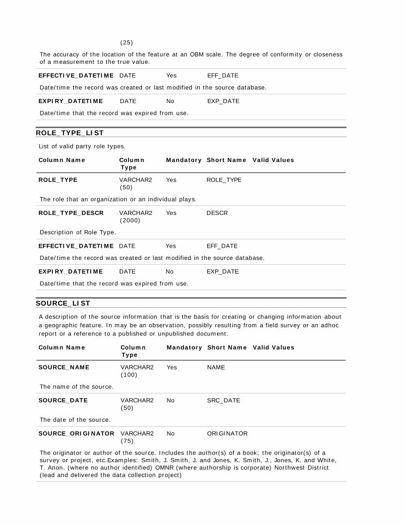
Date/time that the record was expired from use. SOURCE_LIST
A description of the source information that is the basis for creating or changing information about a geographic feature. In may be an observation, possibly resulting from a field survey or an adhoc report or a reference to a published or unpublished document.
Column Name Column
Type Mandatory Short Name Valid Values
SOURCE_NAME VARCHAR2
(100)
Yes NAME
The name of the source.
SOURCE_DATE VARCHAR2 (50)
No SRC_DATE
The date of the source.
SOURCE_ORIGINATOR VARCHAR2 (75)
No ORIGINATOR
The originator or author of the source. Includes the author(s) of a book; the originator(s) of a survey or project, etc.Examples: Smith, J. Smith, J. and Jones, K. Smith, J., Jones, K. and White, T. Anon. (where no author identified) OMNR (where authorship is corporate) Northwest District (lead and delivered the data collection project)
SOURCE_SCALE VARCHAR2 (15)
No SCALE
The scale of the vector base or aerial photography, the cell resolution of a grid, or the pixel resolution of an image used to record the location of the feature. Examples: For a vector source or aerial photography: 1:10,000 1:20,000 1:250,000. For a grid or imagery source: 1 km, 10 m, 15 seconds.
HORIZONTAL_DATUM VARCHAR2 (10)
No H_DATUM
Identifies the reference system used for defining the coordinates of points. There are three common horizontal datum systems used in Ontario: NAD83, NAD27, NAD27 with 1974 adjustment. The datum models the shape of the earth.
VERTICAL_DATUM VARCHAR2 (30)
No V_DATUM
The zero surface to which elevations or heights are referred is called a vertical datum. Traditionally, surveyors and mapmakers have tried to simplify the task by using the average (or mean) sea level as the definition of zero elevation, because the sea surface is available worldwide. MSL is a close approximation to another surface, defined by gravity, called the geoid, which is the true zero surface for measuring elevations. Example: WGS-84 EGM96 Geoid.
SOURCE_PROJECTION VARCHAR2 (40)
No PROJECTION
The name of a systematic representation of all or part of the surface of the Earth on a plane or developable surface.
EFFECTIVE_DATETIME DATE Yes EFF_DATE
Date/time the record was created or last modified in the source database.
EXPIRY_DATETIME DATE No EXP_DATE
Date/time that the record was expired from use.
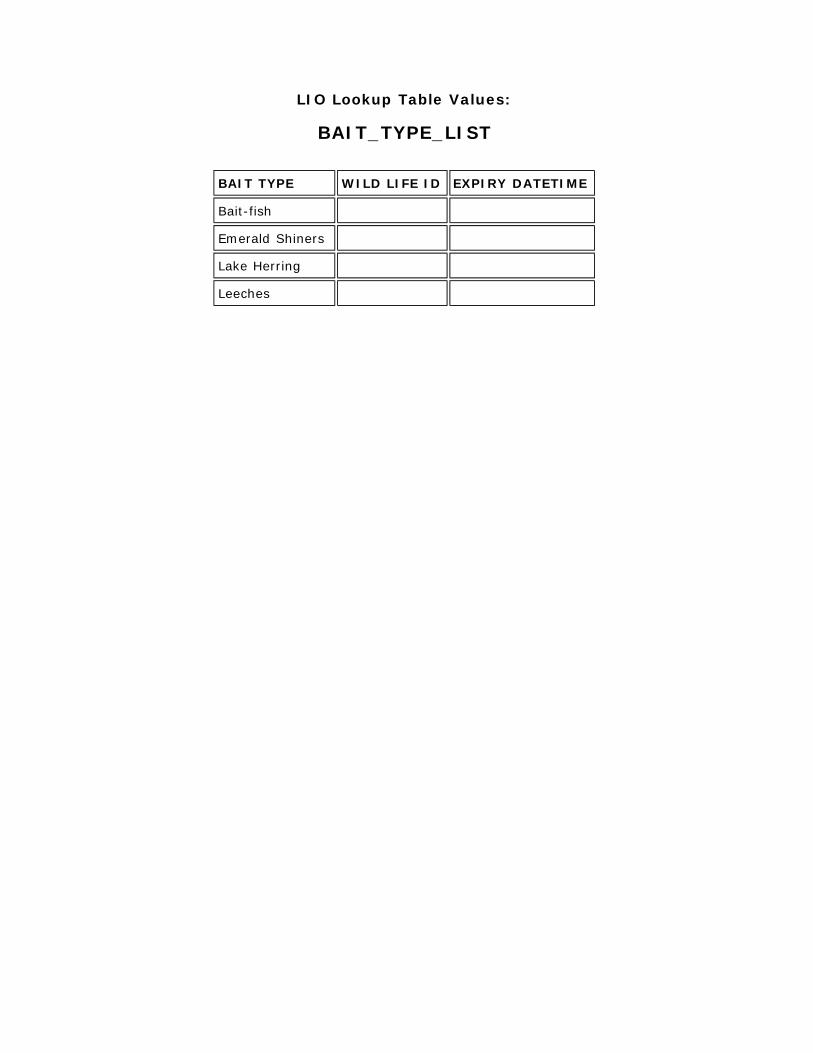
LIO Lookup Table Values:
BAIT_TYPE_LIST
BAIT TYPE WILD LIFE ID EXPIRY DATETIME
Bait-fish
Emerald Shiners
Lake Herring
Leeches
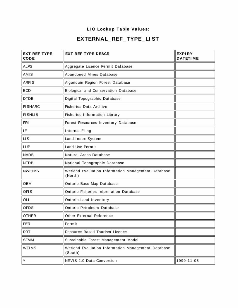
LIO Lookup Table Values:
EXTERNAL_REF_TYPE_LIST EXT REF TYPE CODE
EXT REF TYPE DESCR EXPIRY DATETIME
ALPS Aggregate Licence Permit Database
AMIS Abandoned Mines Database
ARFIS Algonquin Region Forest Database
BCD Biological and Conservation Database
DTDB Digital Topographic Database
FISHARC Fisheries Data Archive
FISHLIB Fisheries Information Library
FRI Forest Resources Inventory Database
IF Internal Filing
LIS Land Index System
LUP Land Use Permit
NADB Natural Areas Database
NTDB National Topographic Database
NWEIMS Wetland Evaluation Information Management Database (North)
OBM Ontario Base Map Database
OFIS Ontario Fisheries Information Database
OLI Ontario Land Inventory
OPDS Ontario Petroleum Database
OTHER Other External Reference
PER Permit
RBT Resource Based Tourism Licence
SFMM Sustainable Forest Management Model
WEIMS Wetland Evaluation Information Management Database (South)
^ NRVIS 2.0 Data Conversion 1999-11-05
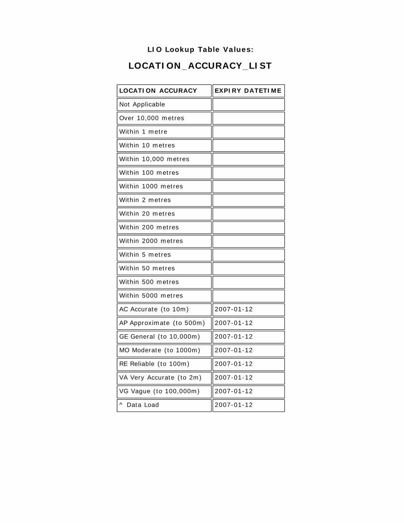
LIO Lookup Table Values:
LOCATION_ACCURACY_LIST
LOCATION ACCURACY EXPIRY DATETIME
Not Applicable
Over 10,000 metres
Within 1 metre
Within 10 metres
Within 10,000 metres
Within 100 metres
Within 1000 metres
Within 2 metres
Within 20 metres
Within 200 metres
Within 2000 metres
Within 5 metres
Within 50 metres
Within 500 metres
Within 5000 metres
AC Accurate (to 10m) 2007-01-12
AP Approximate (to 500m) 2007-01-12
GE General (to 10,000m) 2007-01-12
MO Moderate (to 1000m) 2007-01-12
RE Reliable (to 100m) 2007-01-12
VA Very Accurate (to 2m) 2007-01-12
VG Vague (to 100,000m) 2007-01-12
^ Data Load 2007-01-12
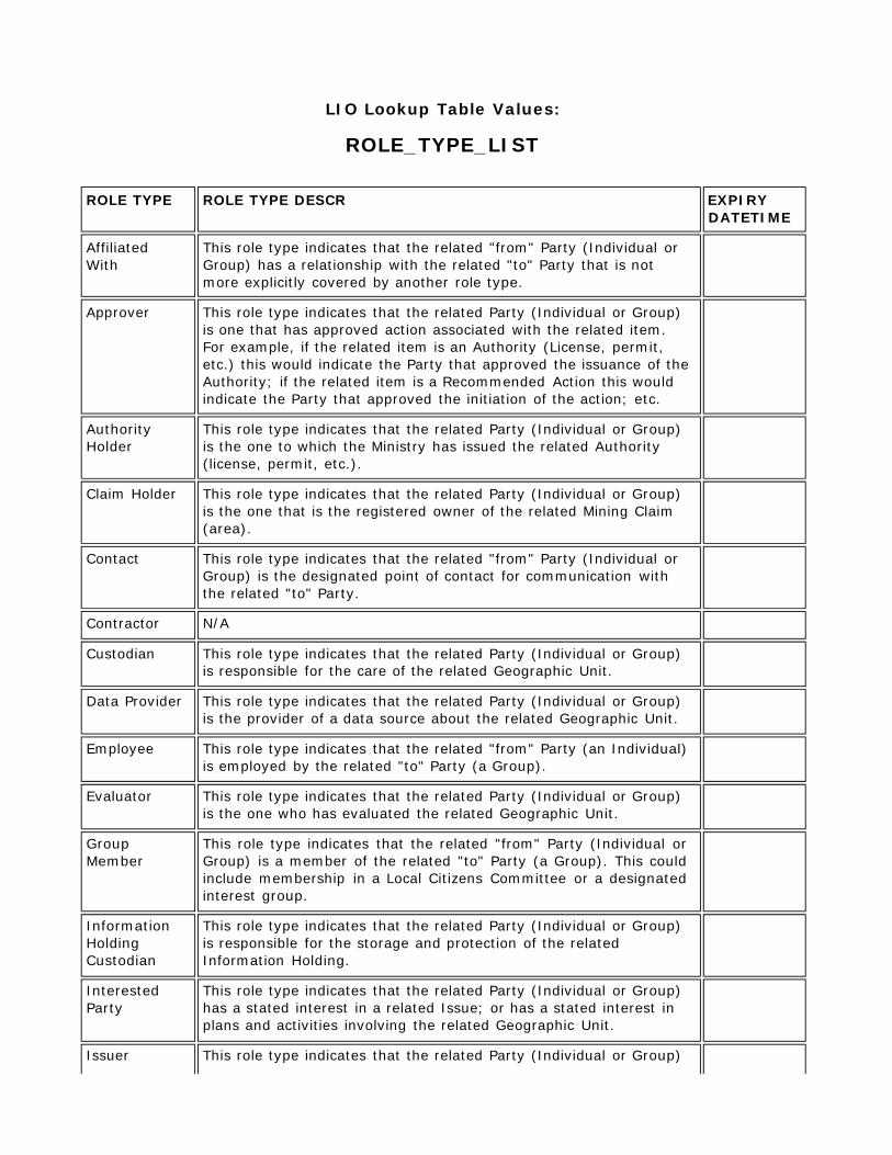
LIO Lookup Table Values:
ROLE_TYPE_LIST
ROLE TYPE ROLE TYPE DESCR EXPIRY
DATETIME
Affiliated With
This role type indicates that the related "from" Party (Individual or Group) has a relationship with the related "to" Party that is not more explicitly covered by another role type.
Approver This role type indicates that the related Party (Individual or Group) is one that has approved action associated with the related item. For example, if the related item is an Authority (License, permit, etc.) this would indicate the Party that approved the issuance of the Authority; if the related item is a Recommended Action this would indicate the Party that approved the initiation of the action; etc.
Authority Holder
This role type indicates that the related Party (Individual or Group) is the one to which the Ministry has issued the related Authority (license, permit, etc.).
Claim Holder This role type indicates that the related Party (Individual or Group) is the one that is the registered owner of the related Mining Claim (area).
Contact This role type indicates that the related "from" Party (Individual or Group) is the designated point of contact for communication with the related "to" Party.
Contractor N/A
Custodian This role type indicates that the related Party (Individual or Group) is responsible for the care of the related Geographic Unit.
Data Provider This role type indicates that the related Party (Individual or Group) is the provider of a data source about the related Geographic Unit.
Employee This role type indicates that the related "from" Party (an Individual) is employed by the related "to" Party (a Group).
Evaluator This role type indicates that the related Party (Individual or Group) is the one who has evaluated the related Geographic Unit.
Group Member
This role type indicates that the related "from" Party (Individual or Group) is a member of the related "to" Party (a Group). This could include membership in a Local Citizens Committee or a designated interest group.
Information Holding Custodian
This role type indicates that the related Party (Individual or Group) is responsible for the storage and protection of the related Information Holding.
Interested Party
This role type indicates that the related Party (Individual or Group) has a stated interest in a related Issue; or has a stated interest in plans and activities involving the related Geographic Unit.
Issuer This role type indicates that the related Party (Individual or Group)
is one that has issued the related Authority (license, permit, etc.).
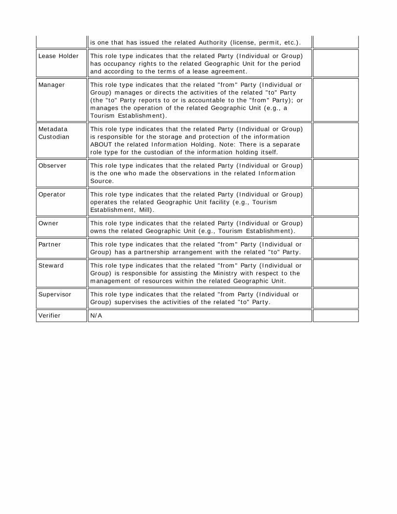
Lease Holder This role type indicates that the related Party (Individual or Group) has occupancy rights to the related Geographic Unit for the period and according to the terms of a lease agreement.
Manager This role type indicates that the related "from" Party (Individual or Group) manages or directs the activities of the related "to" Party (the "to" Party reports to or is accountable to the "from" Party); or manages the operation of the related Geographic Unit (e.g., a Tourism Establishment).
Metadata Custodian
This role type indicates that the related Party (Individual or Group) is responsible for the storage and protection of the information ABOUT the related Information Holding. Note: There is a separate role type for the custodian of the information holding itself.
Observer This role type indicates that the related Party (Individual or Group) is the one who made the observations in the related Information Source.
Operator This role type indicates that the related Party (Individual or Group) operates the related Geographic Unit facility (e.g., Tourism Establishment, Mill).
Owner This role type indicates that the related Party (Individual or Group) owns the related Geographic Unit (e.g., Tourism Establishment).
Partner This role type indicates that the related "from" Party (Individual or Group) has a partnership arrangement with the related "to" Party.
Steward This role type indicates that the related "from" Party (Individual or Group) is responsible for assisting the Ministry with respect to the management of resources within the related Geographic Unit.
Supervisor This role type indicates that the related "from Party (Individual or Group) supervises the activities of the related "to" Party.
Verifier N/A
LIO Lookup Table Values:
SOURCE_LIST SOURCE NAME SOURCE
DATE SOURCE ORIGINATOR
SOURCE SCALE
HORIZONTAL DATUM
VERTICAL DATUM
SOURCE PROJECTION
EXPIRY DATETIME
AFFM Provincial Administrative Maps
Ministry of Natural Resources
600000
Aerial Photography
Ministry of Natural Resources
15840
Aerial Survey
Book/Publication
CIR Photograpy Ministry of
Natural Resources
City of Ottawa Borehole Database
1883 - 2006
City of Ottawa Varies Mean
Average Sea Level
Geodetic and UTM
Digital File
Digital Map
Field Survey\Site Visit
File System/Filing Cabinet Information
Forest Resources Inventory
Ministry of Natural Resources
NAD27 UTM
GPS Data Collection
Hard Copy/Paper Map
IKONOS Multispectral
Ministry of Natural Resources
IKONOS Panchromatic
Ministry of Natural Resources
IRS Multispectral Ministry of
Natural Resources
IRS Panchromatic
Ministry of Natural Resources
IRS Pansharpened
Ministry of Natural Resources
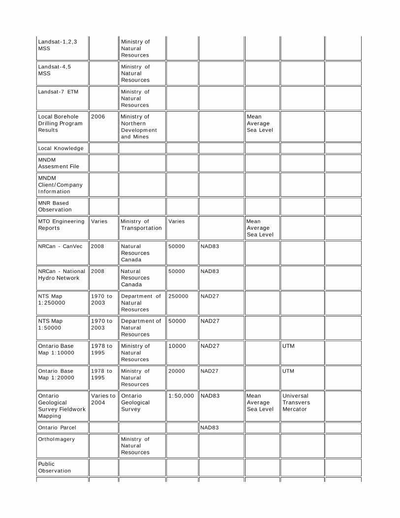
Landsat-1,2,3 MSS
Ministry of Natural Resources
Landsat-4,5 MSS
Ministry of Natural Resources
Landsat-7 ETM Ministry of
Natural Resources
Local Borehole Drilling Program Results
2006 Ministry of
Northern Development and Mines
Mean Average Sea Level
Local Knowledge
MNDM Assesment File
MNDM Client/Company Information
MNR Based Observation
MTO Engineering Reports
Varies Ministry of
Transportation
Varies Mean
Average Sea Level
NRCan - CanVec 2008 Natural
Resources Canada
50000 NAD83
NRCan - National Hydro Network
2008 Natural
Resources Canada
50000 NAD83
NTS Map 1:250000
1970 to 2003
Department of Natural Reosurces
250000 NAD27
NTS Map 1:50000
1970 to 2003
Department of Natural Resources
50000 NAD27
Ontario Base Map 1:10000
1978 to 1995
Ministry of Natural Resources
10000 NAD27 UTM
Ontario Base Map 1:20000
1978 to 1995
Ministry of Natural Resources
20000 NAD27 UTM
Ontario Geological Survey Fieldwork Mapping
Varies to 2004
Ontario Geological Survey
1:50,000 NAD83 Mean
Average Sea Level
Universal Transvers Mercator
Ontario Parcel NAD83
OrthoImagery Ministry of
Natural Resources
Public Observation
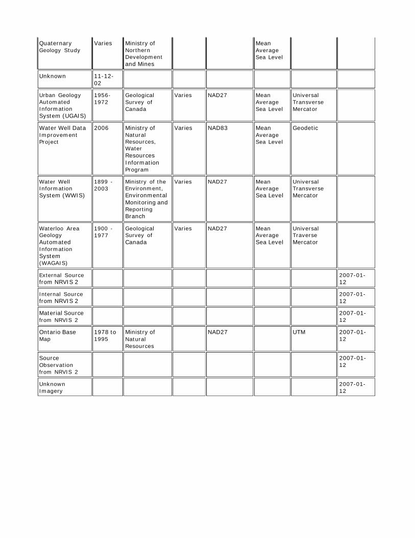
Quaternary Geology Study
Varies Ministry of Northern Development and Mines
Mean Average Sea Level
Unknown 11-12- 02
Urban Geology Automated Information System (UGAIS)
1956- 1972
Geological Survey of Canada
Varies NAD27 Mean Average Sea Level
Universal Transverse Mercator
Water Well Data Improvement Project
2006 Ministry of Natural Resources, Water Resources Information Program
Varies NAD83 Mean Average Sea Level
Geodetic
Water Well Information System (WWIS)
1899 - 2003
Ministry of the Environment, Environmental Monitoring and Reporting Branch
Varies NAD27 Mean Average Sea Level
Universal Transverse Mercator
Waterloo Area Geology Automated Information System (WAGAIS)
1900 - 1977
Geological Survey of Canada
Varies NAD27 Mean Average Sea Level
Universal Traverse Mercator
External Source from NRVIS 2
2007-01- 12
Internal Source from NRVIS 2
2007-01- 12
Material Source from NRVIS 2
2007-01- 12
Ontario Base Map
1978 to 1995
Ministry of Natural Resources
NAD27 UTM 2007-01- 12
Source Observation from NRVIS 2
2007-01- 12
Unknown Imagery
2007-01- 12