Embed Size (px)
Citation preview
# !
NATIONAL AERONAUTI.'.;S AND SPACE ADMINISTRATION
Technica:iReport No. 32-908
bampling and Handling of Desert Soils
R. E. Cameron
G. B. Blank
D. R. Gensel
GPO PRICE $
CFST! PRICE(S) $
N66" 238 60 ..,, co,_(._) _.,_o=,. ,^cc_._,,_,,....._,.,,, ,"r.,,_, Microfiche (MF) __ _c"_ _o .,_$I_" _PICES_ / ff 653 Ju_v E5
--(_l "1_ A C R O F"* 3' _" O"R A-'_ _"_" B E R I (cA"rE ) '
i,IdF_ JET PROPULSION LABORATORYCALIFORNIA INSTITUTE OF TECHNOLOGY
PASADENA_ CALIFORNIA
April 15, 19.66
\
;i
1966014571
https://ntrs.nasa.gov/search.jsp?R=19660014571 2018-06-23T16:49:12+00:00Z

NATIONAL AERONAUTICS AND SPACE ADMINISTRATION
Technical Report No. 32-908
Sampling and Handling of Desert Soils
R .E. Cameron
G. B. Blank
D. R. Gense;
.....orow,.'.,,,,,a,'.ag._/Bioscience Section
JET PROPULSION LABORATORY
CALIFORNIA INSTITUTE OF TECHNOLOGY
PASADENA, CALIFORNIA
April 15, 1966
1966014571-002
JPL TECHNICAL REPORT NO. 32-908
CONTENTS
I. Introduction..................... 1
A. SoilVa_ffab_ty ................... 1B. Histonea!Studies.................. 3
C. Purpose ..................... 4
II. Selection and Characterizo.';onof Area, Site, and SO_I .... 5A. Soil Unit ..................... 5
B. Soil Area ..................... 5
C. Soil Site ..................... 5
D. Observationsof Area, Site, and Soft ............ 6
III. Photography of Area, Site,and Soil ........... 8
IV. Sterilization of Soil Sampling Equipment and Containers . 9
V. Soil Sample Collection ................ 10
Vi. SoilSample Transportand Shipment ........... 12
VII. Soil Sample Handling, Processing,and Storage ....... 12
VIII. JPLSoil Sample Dispersal ............... 13
References ....................... 14
Appendix A. Sequenceof Stepsfor Collecting Soil Samplesin Desert Areas ................ 15
Appendix B. SoilSample Informotion Sheet andAccompanying Photographs ...........
Appendix C. SuggestedMinimum Equipment Ust'/or SoilSample Collecting ............... 31
Appendix D. Nomenclature ............. 32
PRECEDINGPAGEBLANKNOTFILMED.J
1966014571-003

JPL TECHNICAL REPORT NO. 32-908
ABSTRACT _ _ _ (o
Variability and characteristics of terrestrial soils and variability in
methods and techniques used in sampling and handling are important
factors responsible for discrepancies in results of investigations on
soils. Procedures for soil sampling, as well as selection of the soil to
be sampled, are usually determined by the purpose for which the
soil will be used. Information is presented for the sequential selec-
tion, characterization, and sampling of a desert soil site. Procedures
are recommended and illustrations given for photegraphy of major
features, sterilization of sampling equipment and sample containers,
the collection of desert soils, and their handling, processing, storage,
shipment, and dispersal. Aseptic technique is empb.asized for the
collection and handling of soil samples for microbiologic.-.l studies.
I. INTRODUCTION
A. Soil Variabilily and formed under the influence of corr,plex and interact-
Soil sampling is an important factor in various soil ing forces of time (geological), dhnate, topography,studies because most terrestrial soils are not homo- biota, parent materials (minerals), elevation, and geo-
gencous, nor are they simple systems. Except in a strict graphical position, as well as other factors (Refs. 1 and":ngineering sense, soils are not just unconsolidated 2). Differences between various kinds of soils dependmasses of small-sized geologic materials in terms of their considerably on the intensity and degree of action andphysical components. On this planet, soil is a three- interaction of soil-forming factors. Variability in the
interaction of these forces results in the developmentdimensional body, usually a living system, which has and formation of an immense number of soils on thisdeveloped in nature. Differences in the raw soil-formingmaterials and the natural environment have contributed, planet.in time, to the development and formation of different
kinds of soils. Given the same soil-forming factors, the same kindof soil will be formed, whether it occurs at some loea-
Soils can vary on a point-to-point bas:,s and from tion on this planet, or in some extraterres_ial environ-ecosystem to ecosystem insofar as they are developed ment. The same kind of soil will not be formed at a
1
Pl
1966014571-004
JPL TECHHICAL REPORT NO. 32-908
given location unless the same soil-forming factors are is essential to understanding the soil arid its behavior.
operative to the sar_ae degree. The less the interaction This also includes factors responsible for the develop-between factors and the lower the degree of intensi_ merit, formation, degree of maturity, and degradationof each factor involved in soil formation, the lower the of the soil, as well as comprehensive characteristics odegree of complexity and maturity of the soil. Con- the soil ecosystem.versely, the opposite is also true. For example, a high
interaction and intensity, of climate (especially favorable Accessibility of the sample must be considered since
moisture-temperature regime), and biota (especially it inchldes factors related to the best time for obtainhadense, deep fibrous-rooted vegetation) will give rise to the sample and the time that mu:_t be spent in procurin_a high degree of soil development, and complexity, even the sample, location of the sampling site, depth andthough other factors of soil formation are similar to those volume of sample required, design, bias and capabilityof a less complex soil. of the sampling devices, and transport and shipmen
of the sample from the site to another location, such asA number of methods have been used to sample soils for analytical or experimental purpcses.
and a variety of investigations have been performed onsoils, but it has not been possible to devise a singlemethod which is entirely preferable and satisfactory for For a given area and sampling site, variability of solsampling all kinds of soils at all times and in all loca- properties may be quite important. For example, an area
of dune sand, or a broad, level, arid plain may showtions. Shallow, rocky soils must be sampled, as weU asdense, aggregated, cemented, and compacted soils, or only a few soils with a narrow range of variability insoils composed of loose, cohesionless, drifting dunes, soft properties. However, in a large area varying fromSampling capability must extend to the dislodgment of a barren desert peneplain to wet, densely vegetatecin situ clays, silts, sands, and loams, as well as other mountains of increasing elevation, and correspondiP,_larger geologic materials in various states of structural changes in climate, radiation fluxes, and different minera-arrangements, logical composition, soils can vary widely from point to
point, from ecosystem to ecosystem, and hence in individ-
Productive soils, or those occurring in agricultural ual properties of a single unit of soil.
regions, usually have weU-developed profiles of distinct
A, B, C horizons and subhorizons, and these soils corn- Considering all of the factors in soil sampling, it hasmonly show considerable variability in their character- been found that the purpgse and use for which the so/istics with depth of soil profile. Desert soils may show sample is required usually deten._ines the k_nd of soi
much less variability of morphology or other character- and the method of sampling (Ref. 3). The purpose alsoistics with depth and are usually azonal, although hard- largely determines the quantity, quality, and depth ofpan or caliche layers may occur, sample, the time of sampling, the number of samples,
the selection of the area and choice of sampling sites,Whichever methods are selected and utilized to sample and subsequent procedures followed during the "lifetime"
a soil, at least six factors must be considered: (1) charae- of the sample.teristics of the environn_ent external to a given body of
soil; (2) soil-environmental relationships and interac- For most soil studies, it is desirable to collect a volume
tions; (3) accessibility of the sample in terms of feasi- of soil, ,'_ther than an area of soil (Ref. 3). In mostbility of procurement from the natural environment; instances, this means that the investigator must obtain(4) the variability, as well as the representative charac- a soil unit which is a representative sample from a par-teristics, of the sample; (5) the handling, processing, ticular body of soil or soil ecosystem (Ref. 2). To ensuretreatment, shipping, storage, and other conditions that the collection of a representative and reasonably homo-will be imposed upon the soil after it has been removed geneous soil sample, a number of dislodged samples orfrom the natural environment; (6)the purpose for which sample units are ordinarily collected from a body ofthe soil sample is required, i.e., the analyses and Jnvesti- soil. These samples are then mixed together, and angations which will be performed on the soil. aliquot is taken as the representative sample of soil.
It is not always possible to satisfy all of the criteriafor soil sampliug, and some factors must receive priority For some studies, a selective sample, such as from aover others. The soil should be considered in relation to specific area of soil or soil microenvironment, is pro-its external environment. Knowledge of field conditions cured. A selective sample, rather than a random sample,
2
1966014571-005
JPL TECHNICAL REPORT NO. 32-908
may also be desired, or even necessary, for some experi- be procured from the "plow layer" or first 12 in. of soil.mental design purposes, e.g., qt:alitative detection of Samples taken from the immediate surface or less thansoil microflora populations or other organics. 12 in. depth would not be co_idered for examination.
It was also required that samples should not be randomlyProcedures for collecting and handling of soil samples collec/ted, but selected from distinct kinds of soils, and
must be determined prior to actual procurement of that they should be from nondisturbed or "v.ncontami-samples in the field. In this respect, procedures for col- nated" areas.lection of ;_oilsa'.nples for physical or chemical analyses
are 9ot the sartae as for procurement of samples for soil Before shipment or transport, the soil was to be sep-monoliths, or for microbiological analyses and research, arated from macrovegetation, and the samples were to
be homogeneous from several representative sampling
It should be realized that precautionary techniques sites. Observed changes in soil characteristics with depthfor procurement of soft samples for microbiological in- of soil were to be noted by the collector, and it wasvestigations are not rou_nely utilized when obtaining advised that cultiw.ted, as well as adjacent virgin soilssoft samples. Methods for collection of soil samples in should be procured. It was also recommended that theorder to preclude covtamination have not been well occurrence of normal vegetation should be carefully
developed or tested. In this respect, it is quite difficult noted and recorded, and that soil sites with unusualto obtain a quantity of soil from subsurface depths with- plants or vegetative grov,_th should be avoided.out introducing contamination from surface soil.
!n arid areas, it was suggested that samples of alkali
Procatrement of worthwhile and scientifically valuable or salty soils should be collected toward the end of thesoil samples depends considerably upon the capabilities, dry season when surface layers contained the largestpreparation, and experience of the individual collector amounts of evaporated salts. All wet samples were toor investigator. Errors in soil seanpling are increased by be air-dried before shipping or storing, and no soilsinadequate preparation, lack of sv.mpling experience, were examined unless notes on soil location, lay of thelack of a rudimentary knowledge of basic soil principles land, soil "peculiarities," crop or vegetation, accompanied
the sample. Otherwise, "the amount of labor involvedand characteristics, poor choice of a sampling site, pro-curement of an insufllcient quantity of sample, use of [does not warrznt] their examination" (Ref. 5).improper sampling methods and techniques, impropertreatment, handling, storage, and shipment of the sample, Soil sample collection and handling procedures haveinattention to the time of sampling with regard to evolved from the above requirements outlined by the firstenvironmental and soil conditions, and failure to take outstanding United States soil scientist, E W. Hilgard
sut_cient notes on characteristics of the sampling s_te, (fief. 5). Most of these principles for the collection andits environment, or other factors which influence, the handling of soil sranples have been retained to date.
status of the collected sample. Errors due to ._ampling Although several modifications have been made forof soils are generally greater than those of soil. analyses research purposes, most agricultural soils are still col-(Ref. 3), and these errors in sampling could affect the letted within 12 in. of the surface or from distinct hori-value of the soils for other purposes. As indicated above, zons which compose the soil profile."ny one factor or combination of factors can contribute to
collection of samples with decreased or very little Little or no regard is usually given to slight contamina-_,.,entiBe value. Sampling reliability must be e.-nphasized tion of successive layers or depths of soil by surfaceat all times, soil. No procedures are routinely followed for steriliza-
tion of digging tools, samplers, or sample containers.Aseptic techniques, except for specific microbiological
B. Historical Studies purposes, are not used during the collecting and process-Methodology of soil sanaple collection shows that most ing of soils, and this contributes to the contamination
soils have been sampled for use in soil science or of samples by nonindigenous organisms and other mate-agronomy. Primarily, soil samples have been obtained rials. It is still standard practice to air-dry soils before
for analytical purposes with reference to agriculture, and shipping, storage, or determination of soil properties,many subsequent examinations of softs have been under- but care is not ordinarily taken to exclude laboratory ortaken by the various state and county agriculture experl- open-air contamination of soil samples during the processmeat stations. Acoording to one of the earliest accounts of drying or other treatment. A time period of 24,48 hrof soil sampling (Ref. 5), it was required that samples or longer is commonly allowed to dry a soil. The soil
3
1966014571-006

JPL TECHNICAL REPORT NO. 32-908
may be exposed to open-air contamination for ._ longer quent methods and techniques presented in this Reporttime period, depending considerably upon the time and are similar in some respects to soil sampling and han-convenience for repackaging and for investigating the dling procedures generally utilized by many soil scientists.soil. However, the suggested procedures have evolved through
experience gained in the aseptic collection and handling
of hundreds of soils which have been analyzed for theC. Purpose JPL Desert Microflora Program.
Procedures for sampling and handling of soils are
presented in this Report on the basis of procurement of Instructions are also included for those who may wantmanually dislodged samples of soil or sampling units to contribute to or obtain soils from the Desert Soil
which are to be removed from the field in a desert area. Collection at the Jet Propulsion Laboratory. 2 A typicalInstructions are intended for individuals who have had Soil Sample Information Sheet and pictures of the
some experience in soil sampling, as well as for the corresponding soil site are included for this p,'rpose ininexperienced collector who lacks any background in Appendix B. Additional information on standard prac-soil science or in the procurement of soil samples from rices of soil sampling, equipment for sampling, andthe field. Emphasis is given to procurement of desert characterization of the sampling site can be found insoil samr, les of biological quality_ and stress is given to sections of some soil texts (Refs. 4-10). Useful irfforma-the use of aseptic techniques which must be utilized in tion to observe and record at the soil site, and for aorder to avoid sample contamination. The soil survey given depth of soil profile, are emphasized in a fewmethod of soil pit excavation and examination is utilized works on soils (Refs. 11-13). Sources of error in sampl2ng
for obtaining large quantities of samples, and for the have been given E/ Cline (Ref. 3) and Petersen andconvenience of personnel in making soil depth measure- Calvin (Ref. 14). Sampling of desert soils and theirments. The instructions are summarized and simple physical, chemical, and microbiological properties withillustrations are given in Appendix A. reference to extraterrestrial life detectors and samplers
have been presented previously (Ref. 15). It is assumedIt is not the purpose of this Report to present basic that the collector who intends to undertake soil sam-
characteristics of desert soils, various types of soft sam- piing in a remote desert area will have made adequatepiing devices and equipment, preparation of soil mono- preparation prior to his departure.liths, or to suggest soil tests and anal 3ses. 1 The subse-
'Cameron, R. E., Blank, G. B., and Gensel, D. R., Desert Soil1Cameron,R. E., Blank, G. B., and Censel, D. R., Soil Tests, Meas- Collection at the ]PL Soil Science Labo_'atory.JPL Technicalurements, and Properties,JPL Technical Report, in preparation. Report, in preparation.
4
1966014571-007
JPL TECHNICAL REPORT NO. 32-908
II. SELECTION AND CHARACTERIZATION OF AREA, SITE, AND SOIL
For soil studies in the JPL Desert Microflora Program, veniently scrutinized, reasonably identified, and charac-certain precautionary methods and techniques must be terized by visual means.
used for the collection, handling, processing, and storageof soils.:' In this respect, older methods of soil sampling The collector should allow a reasonable time Fzriodhave been modified or replaced, especially wiffi regard in order to "survey" the area before deciding w},etherto the application of aseptic techniques and methods in o_"not it c_ntains sites suitable for sampling. Som_ oforder" to exclude or minimize microbiological contamina- the more conspicuous area features may indicate thetion for collection of surface, as well as depth samples density, distribution, and types :,f vegetation and ani-
of soil. The procedures given below have beea devel- mals, relative proportions of soil :,ad lock, land fcrr_s,oped through trial and error, and they have also been erosion and drainage features, direction of prevailingused successfully by individuals who have not t:ad a winds, slope of land, elevation, etc. The area should be
background in soil science or who have not had pre- traversed and observed to some extent, either by slowvious experience in the collection of soils for microbic,- vehicle or on foot, before a final selection is made of thelogical research purposes. .soil site. While examining the area, take care to avoid
contaminating soils which may later be used forsampling.
A. Soil Unit
C. Soil SiteA soil sample is obtained from a larger portion of a
soil body or ecosystem, and it is commonly referred to The soil site is a working unit or subportion of theas a "sampling unit" (Ref. 3). The soil sampling unit is soil area or terrain which is suit_.ble for soil sampling.a quantity or volume of soil which has arbitrary limita- It has three-dimensional characteristics which are con-
tions and dimensions for descriptive purposes, and it venient for sampling. For practical purposes, the soil
also possesses characteristics which can be defined or sta- site is arbitrarily delimited as the soil ecosystem. Ittistically estimated by sets of stable numbers (parameters). should be accessible, as ,well as convenient for various
personnel operations at the site.The soil sampling unit is a useful working unit, and it
cart be used for various experimental design purposes and It is important to check the site for evidences of con-studies. It usually possesses some characteristics of the tamination. Insofar as possible, a soil site is chosen whichlarger soil body from which it is procured. It, t._.refore, does not show contamination by humans, animals,has some characteristics of a three-dimensional soil sys- vehicles, or trash. Evidences of contamination are foot-tern in terms of area and volume, its physical, chemical, prints, disturbed vegetation, animal tracks, vehicle tracks,
and microbiological systems, and solid (inorganic and discarded bottles, cans, cigarette wrappers, expendedorganic), gas and/or liquid phases. A soil sampling unit ammunition cartridges, dung, feathers, anthills, rodentis not the natural soil after it has been separated from holes, etc.the site, but a soil sampling unit is always a representa-
tive portion of the site, and the quantity, quality, and Wherever possible, a site should be chosen which isreplication of this unit are usually a matter of choice, not covered by, or adjacent to vegetation (trees, shrubs,
convenience, and purpose. A sufficient quantity of sam- bushes, grasses, reraains of recent or partially decom-pie unit should be collected from the soil site insofar posed plant debris, etc.). In deserts, small animals oras possible, evidences of small animals are commonly observed
around shrubs which provide them with food, shelter,B. $eil Area and protection from predators. An attempt should be
The soil area refers to a broad exposure or expanse of made to choose a sampling site which is in an opensoil, and associated rock, vegetation, topographic forms, expanse of bare soil, unless it is also de._ired to obtainand various other inclusive natural features. It includes samples from soil around vegetation and the correspond-
a reasonable portion of the terrain which can be con- ing rhizosphere.
'_Cameron,R. E., "Collection of Soils for the Program on Desert Sampling sites should be avoided which are composedMiemflora,"August 1964. entirely of rock surfaces, but if there is no soil present
5
1966014571-008

JPL TECHNICAL REPORT NO. 32-908
in the area, then it may be desirable to dislodge and Badlands, for example, are complex, mature topo-
collect rock samples utilizing the same recommended graphic forms which develop in many desert regionsptic procedures as those for collecting soils, subject to deluges. Badland are characterized by l_,arrow,
steep-sided, valleys and narrow-crested hills, the entireFollowing selection of the soil site, co_ltinue to take area showing dissections by numerous gullies or arroyos
care not to contaminate it. Do not walk on the sitel and closely spaced valleys. Rocks that compose most
Sometimes the best sites in an area are contaminated badlands are alternating shales and sandstenes, or pre-while the area is being examined. Also be careful not dominatelv shales. Much of the Painted Desert in
to stir up dust, or disturb vegetation which may fall into Arizona is a typical badlands desert region.the site, and do not deposit any collecting devices, instru-
ments, sample sacks, wearing apparel, or other para- Vegetation, or the lack of it, is quite often charaeter-phernalia within the site. istic of a particular desert region. Especial._y note the
At this time, measure and record any desirable micro- kinds or typ._'s of vegetation, e.g., xerophytic shrubs,climatic or soil properties, e.g., soil pH, oxidation- cacti, short grasses, etc. Determine which kinds ofreduction potential (Eh), moisture, density, infiltration vegetation are the most abundant or typical. Note the
distributi 3n of the various kinds of vegetation (scattered,rate, refleetivity, soil color, temperature, and humidity, irregular, ¢_veven), and the amount of vegetative growth
D. Observations of Area, Site, and Soil (prolific, moderate, or scant).
After the site has been selected, the area s,Jrrnu_4hl:g I)epe.nding on the time of year, climate, local weatherthe site should be more carefully exarni_ed. These (especially as to favorable mgisture-temperature con-observations should be made as complete, ob;ective, and ditions), as well as off.er factors, reproductive stages ofclear as possible, and should be recorded in a ilo_ebook, some plants may be c.bserved. If possible, make an esti-
Exami/ne the general topography, as to whether it is mate of the age and ap{:arent health of the vegetation,mountainous, hilly, steep, gently rolling, flat, etc. e.g., dried grasses, ,:_.,,.. _r dehiscent leaves, stunted,
twisted shrubs, flaccid c....'i, desiccated lichens, etc. Ef-Note the erosion patterns (gully or she_:i _ee of fects of fire can som,.tif_:_ be noted, with evidences of
erosion (severe, moderate, or slight), and its pxobable charred wood, fire scc_",_ Jcond-growth, or revegetation.source (wind, water, or both). Try to differentiate be-tween natural erosion and accelerated erosio_. W.nd is As an example ¢,: .:_-._ vegetation, the creGsotebush
a dominant gradational factor responsible for -.:os:on is the most w.idelv ' .,_:ibuted, the most evenly spaced,in deserts, but for a relatively short time period, water and the _ost ;_ .,_ . dy encountered, dominant macro-
_,eoctah, _ ,:can have tremendous erosional effects. Sudden deluges -' .... fo:_._ 'i._eSonoran Desert. It is also a trans-that occur in many desert areas provide turbulent, last- it!on plant £,u ;t.; in surrounding deserts, such as therunning, debris-laden water coursing through drainage Mohave. The- giant saguaro cactus is an example of anchannels which eventually end in closed basins, tem- assoemtwe [&mt occurring with the creosotebush, butporary playa lakes (dry lakes), alluvial fans, or piedmont it is found o,: hillsides, in the Arizona Upland regionsalluvial plains, of the larger Sonoran Desel_t.
Landforms, while of significance in field geology, are Observe and record past or present evidences of
also important features to note in the area in relation to animals and the kinds of animals, e.g., cattle, rabbits,the soil site and its development. Note the position, rodents, lizards, birds, etc., and their numbers and degreeextent, arrangement, and composition of prominent of activity. In addition to visual sightings of animals,natural features. Some of the features to note axe flats, record evidences of tracks, paths of travel, feeding re-valleys, fans, teiraces, mesas, buttes, hogbacks, spires, mains, fresh or old bones, feathers, fresh or decomposedpinnacles, canyons, depressions and sink holes, isolated dung, and distribution and numbers of various kinds ofhills, remnants, dunes, sand washes, loess deposits, old burrows, etc.beach deposits, lacustrine a,,d marine depos;ts, cinder,ash or tuff deposits, lava flows, bedrock escarpments, Make notations as to the characteristics of soil(s)with-
glacial till or drift, steep or gentle mountains, scablands, in the area, adjacent to the site, and especially withinbadlands, etc. Attempt to characterize topography as the site itself, where the samples will be collected.to age in terms of conditions of development (not years, Pertinent observations to be m.ade on soils in the fieldbut whether it is young, mature, or old). can be obtained by referring to any of the published
6
1966014571-009
JPL TECHNICAL REPORT NO. 32-908
United States Department of Agriculture Soil Surveys, According to the wore modem U. S. methods of soil
or the U.S.D.A. Soil Survey Manual (Ref. 7). Notations classification, most desert soils fall w_thin the cdtego,Jesshould be made as to the character of the soil slope or and subcategories of entisols or aridisols (Ref. 11). Desertthe inclhle of the soil surface and the microrelief, soils are hot or cold, and they are barren or formed under
mixed xeric shrubs and bunch grass, or o,aly scattered
In actual practice, 3oil slope is a consideration of the shrub vegetation. Available moisture :'s either lacking,entire terrain. Soil slope characteristics are shape, length, low, or sometimes variable. Evaporation exceeds preeipi-and pattern of gradient. Slopes are either (1) single, or tation, except in polar regions where temperatures dc aot(2) slope complexes, as in a rolling terrain, get a_ove freezing.
Mierorelief or __dace forms include desert pavement, Wind and deluge-type water e: osion are definite devel-desert varnish, fluffy or hard salt deposits, angular or opmental factors. So__,_,desert soiI_ are zonal, but mostsmooth pebbles, large or small rocks or cobbles, lag are very slightly .veathered or leached and have either
gravels, loose or coherent sands, dispersed clay, shrinkage faiut soil horizons and are intrazonal, or lack a profile andcracks, etc. Some desert soil surfaces are hard, dispersed, are therefore azonal or structureless. Many desert soils areand compact, whereas others may be loose, dusty, lacking found in large areas of barren, sandy or stony wastes, andin cohesion, or possess a thin to thick fragile or dense many are shallow or frozen (permafrost) soils. Pans orcrust. ¢.er"ontations of calcium, sodium, iron, or silica occur in
desert soils. Organic matter, organic carbon, and nitrogen
Also, record any striking or unusual prope_es of the concentrations are frequently very low; salts, solublesoil which may occur within the site, e.g., various kinds minerals and corresponding pH and Eh values may be
of salt layers, krotovinas, crusts, coc,;.ings, pockets, crystals, h_gh. Fertility may be l_:gh, but productivity is largelynodules, or concretions, conspicuous mineral deposits, dependent upon quantity and quality of available mois-sharp or irregular changes in color (mottlings), irregular- ture for a given time period.ities in structure, textural banding, stone lines, moisture
variations, organic matter accalmulations, etc. Also make notations as to the meteorological andmicrometeorological or microelimatic characteristics, even
Soil texture is sometimes estimated in the field by ex- though these observations may be of a qualitative nature.perienced personnel by the method of "feel" (Refs. 6, 7). Note the kind, amount, and dir'_ibutSon of cloud cover,Rub some of it between the fingers in both its wet and e.g., few, thin, high cix_us clouds, the humidity, winddry ._tates. Notice whether the soil is coarse and single- direction and estimated wind velocity., and temper ture.grained, or very fine and coherent, loosely aggregated,
powdery and fragile, c_ "loddy and hard to break apart. If instruments and time are available for these measure-
Look at some of the soil for fragments of organic matter, ments, ,_'_is advisable to take readings for extended pc-e.g., seed pods, dried grasses, dung, etc. riods, and for a given profile or depth of environment. If
possible, measurements should be made before, during,
Try to evaluate the moisture status of the soil at various and after collection of the samples. Diurnal environ-levels. Observe and feel whether or not the soil is wet, mental measurements are preferable to those made at
slightly damp, dry or very dry, and powdery or dusty, only one point in time. It is also extremely important toIf a depth of desert soil is investigated, influxes or evi- record information while at the sampling site. Afterdences of past precipitation can sometimes be observed departure fro, n the site, it has been found that recall ofas noticeably moist bands or layers of soil. perthaent infornmtion about the area, site, and in situ
features of the soil are not reliable.
Most arid regions have red, grey, yellow, brown, salt
or frozen desert soils. Within older classifications of desert In addition to measurements of humidity, wind, andsoils these soils were included in Great St;Is Groups of temperature, measurements can be made of evaporatienPolar soils, Tundra soils, Grey Desert soils, Sierozem, rate; onset, amount, and duration of dew; solar radiation;
Brown soils, Reddish-Brewn soils, Solonehak, Solonetz, net or total exchange of thermal radiation; occurrenceSoloth, IAthosol, Regosol, and Alluvial soils. This elassi- and duration of sunshine; site elevation, and barometric
fieation scheme is st/ll used by Soviet soil scientists and pressure. Make any additiopal observations or measure-pedologists, ments of interest. Too many notes are preferable to too
7
1966014571-010

JPL TECHNIC,S,L REPORT NO. 32-908
few. Try not to overlook any special or unl,sual features aeterize them. Common words have become technicalin the environment which may have influence on fonna- terms in various branches of science for the purpose oft_on and development of the soil and any of its physical, describing or measuring natural phenomena. Some corn-
chemical and microbiological systems, mon words have been given precise or unusu_! meanings.However, even v4thout a familiarity with concise, tech-
Reference to texts on deserts soil science, pedology, nical terms and their meanings, a number of eoinmon
geology, botany, ecology, geography, and meteorology words can be used in a qualitatave sense in order to pro-can provide useful ir,formation, especially with regard to vide some i.n.formation on the area, sampling site, in situfeatures L-t the natbral environment, and how to char- soil "profile," and the soil sampling unit.
III. PHOTOGRAPHYOF AREA, SITE,AND SO:;.
Photographs are valuable in the characterization of the times from dust, extreme temperatures (especially heat),area, site and soil. In addition to the soil samples and and moisture. After expo_re, films should be marked andrecorded information about the area and sampling s_te, identified, and then developed as soon as possible.photographs are a valuable source of information. Photo-graphs provide an excellent record of observable con- Take too many pictures rather than too few, and makeditions and prominent features at the time of sampling, a record and notatiolts as to where and when the picturesPerP.nent photographs help to define, ilh_trate or con- were taken. If ne_-_essary,al:o record the point of interest.trast and compare one environment and sampling site Try several views, as exposures. Some views tell the storywith other environments and sampling sites. Pictures can better than others. Consider shadows, the angle of in-also be useful in relocating the same rite or similar a.-cas cidence ef the Sun's rays upon the soil surface, color andfor future sampling (Appendix B)._ reflectivity of soft minerals, the microrelief, topography,
and the time of day.Choose views which have a definite bearing on the
subje_ Although _.he subject of the picture should be Take a mizdmum of two exposures of each view, andof scientific interest, the view should also be taken so include at least the following: (1) pictures of the generalas to obtain an artistic balance. Select definite feata;res area, including _veral hundred square meters of terrain,of interest, and hold the camera on a level so as to main- and also include the m "'sturbed soil site: (2) several
tain balances of intersecting perpendicult, r andhorizontal pictures of the sampling site, including the exact locationlines, from which th,. soil will be collected; and (3) the same
as Item (2) above, after the soil has been sampled, in orderIt is recommended that the collector should take two, to show a cut or exposure of soil "profile" characteristics.
or even three cameras if possible. One camera should beused for black and white film, the second for color nega- A fourth picture can be taken in order to show soiltives, and the third fol color slides. Reflex or miniature features from a much shorter distance. Other shots may
came-_s are often preferred, although movie and polaroid be taken of any noticeable soil or associative property,cameras can also be used. Whatever camer_ is used, the e.g., ealiche or mineral nodules, desert pavement, algal-lens should have good to excellent definitior,/e¢pecially lichen crusts, mottlings, fossils, roots, underground bur-for close-up pictures), rows, soil structure, moisture differences, etc. Additional
pictures may include views of typical or unusual vege-
Films are a matter of choice, although high-speed film tation, geologic features, or of collecting operations.is not necessary for most daytirae desert photographybecause of high light intensity. Films are usually carried A recognizable or known reference item should be in-in tins or plastic sacks. They should be prott;eted at all eluded in the pictures, such as a man, meter stick, shovel,
soil moisture tin, or soil site information sign. A soil site's(_ footnote 2. information sign is quite useful. This sign should include
8
1966014571-011
JPL TECHNICAL REPORT NO. 32-908
pertinent information and it should be used when taking ference from heat waves, haze, or atmospheric dust. Aa picture of the soil "profile" pit. Include on the sign the common rule is, don't overexpose the film in desert areas!
date and location of sampling, depth of soil, and soilsample identificatiorA numbers. The soil site information Operator ineptitude is also, a cause of failure to obtainsign helps to associate areas and sampling sites with the photographs, or else it is not always possible to tell whensoil samples that are collected. It has been found that the pictures are good ones. Failure to obtain good picturesunless photographs with proper identifications are made, occurs either through unfamiliarity with the camera, im-it is t_ossible to confuse similar areas and sampling sites, proper choice of film, failure to consider contrasts of lightSometimes areas and sampling sites are quite similar and dark, failure to compensate for high light intensities,although in entirely different geographical regions, improper focus, dusty ions, as well as many other factors.
If ".mfamiliar with the camera to be used on the field
Camera malfunction or scratched ne¢.ttives art not trip, then take pictures with a la'ial roll of film beforeuncommon in the desert. Dust is a primary source of the tn#. A,_terarrival at the sampling site is not the timetrouble. This is because many desert regions are fre- to learn how to operate the camera. (This precaution alsoquenfly windy, dusty, or are subject to dust and/or wind applies to any o_er equipment to bc used on the trip,storms. Dust is sometimes stirred up through activities since spare parts are not available!) In too many instances,
m the area, and especially at the soil site, and this dust it is not practical to return to the area and sampling siteseeps into instruments and equipment. Sometimes good in ease the pictures were improperly taken, or were notdistance pictures cannot be obtained b_use of inter- obtained at all.
IV. STERILIZATIONOF SAMPLING EQUIPMENT AND CONTAINERS
For the purpose of collecting soil samples suitable for and then subjecting them to s'erilization, either by heat,microbiological research and analyses, it is necessary that ethylene oxide gas mixtures, or other sterilants. It hascertain sterilization procedures and aseptic techniques be been found that sterilization of small samplers can beused: (1) The preparation and use of sterile sample con- achieved by autoclaving (IP.0°C for 1-3 hours), or drytainers; (.q) sterilization of samplers and/or digging tools; heat (180°C for 8-10 hr).(3) the use of aseptic techniques to avoid contaminationduring procurement and dislodgment of the sample unit Ethylene oxide sterilization has been used successfullyfrom the in situ soft; (4) the use of aseptic techniques dur- for both sample containers (plastic-lined canvas sacks)ing placement of dislodged samples into containers; and and metal samplers. Use l_g ethylene oxide/88$ Ucon-19,(5) precautionary measures to preclude contamination of for 24-48 hr at room temperature. If possible, sterilize thethe samples during subsequent handling, shipment, treat- sampler, digging, or collecting devices and tools, e.g.,ment, processing, and storage, shovel, pick, jack hammer blade, curved trowel, etc.,
while at th_ sampling site, and just prior to collection ofSterile samplers (and d'.'gging tools) should be used for the soil. If available, use a propane torch or camp stove
collecting purposes. In most cases, these samplers should for sterilization purposes. A propane torch and its fuel
be capable of being sterilized and re-used a number of package are the most convenient to use, but a field oventimes, e.g., metal shovels. In some instances, a sampler or portable autoclave can also be used for small samplers.may be disposable and previously sterilized and packaged,e.g., various plastic items. If only a few samples are to If a camp stove is used, be sure that no carbon frombe collected, and it is not desirable to carry sterilization partially combusted fuel aeclmmlates on the sampler dur-equipment into the field, then small hand shovels or other ing the stei.iization procedure. Also be certain to allowsmall samplers ezn be sterilized in the laboratory prior sufficient time for sterilized samplers to cool. (A hot shovelto departure to the samplit, g site. ''"-_,,u*"*'-,,,_microorganisms, alters the organic matter, and
otherwise changes soil properties.) Avoid contaminationThese items can be prepared in the laboratory by of the samplers during the cooling period, and do not lay
wrapping them in sewra_ layers of heavy aluminum foil, them on the soil unless it is the same kind of soil to be
9
1966014571-012
JPL TECHNICAL REPORT NO. 32-908
collected. (Discard the heated soil.) Re-use the heat- sampler with the same kir, d of soil that is to be collected.sterilizable samplers for successive collections of soil This pxocedure involves shoving the sampler, e.g., shovel,
samples, and follow the same procedures as outlined vigorously into the soil, and taking care not to use thisabove wit}, regard to sterilization and cooling, contaminated soil as par_ of the collected sample.
If no sterile equipment is available for sampling, then The rinsing procedure is also advisable for any sampleran alternate procedure can be followed, so as to reduce whether sterile or not. Rinsing can be recommended for -contamination. In this regexd, be sure that there is no faster cooling of the sa'npler following heat sterilizationadherent material on the sampler from previous investi- at the sampling site, and it also insures the removal or
gations. (Check espetqally for organics.) Also check for dilution and dispersion of air-borne microorganisms orany material which may have accumulated on the sam- dust particles which may have collected on a sampler dur-pling equipment during transport to the field. Rinse the ing the cooling period.
V. SOIL SAMPLE COLLECTION
Prior to sample colleclat, n, check to be sure that all for the JPL Desert Microflora Program, sterile sacks,equipment necessary for sampling and packaging of which will hold about 10 kg of so_, will be provided byramples is conve,iently available and ready for use. JPL ff sufflcient prior netice is received from the collector.
Label the .sample containers with appropriate irfforma- Fill the :acks with representative samples of soil fror,-, thetion as to location of the sar,_pling site (usually named same depth within the site. Do not pack the sack w_l_,after nearest geographical feato_,_, town, etc.), date of soft. Be sure to leave some empty space in the sa,_k ffsampling, depth of sample to be collected (approximately the soil is wet, becatlsse the increased pressure fromthe surface 1 in., 1-43 in., 1 ft, g ft, 3 ft, etc.), sample swelling soil and mi_obial respiration can split the sack.number, and if desired, the collector's name. Include
similar information, or at least the sample number, on It is not necessary to homogenize or mix the samplesoil moisture tins. in the sack, or to sieve it (unless this is desired). Mixing
and sieving can be performed more satisfactorily duringAs a first step in sample procurement, collect the soil the processing of the soil samples in the laboratory
(the sampling unit) from approximately the surface 1 in. where more time is available, and processing conditions(2.5 cm), or from a shallower depth (indicate this depth can be more favorably controlled.on the sample container). In some cases, an easily dis-lodged soil surface crust can be obtained, such as salt
After the sack has been filled with soil, securely tiecrusts, "rain" or clay crusts, or algal or lichen crusts.the neck of the sack with the drawstxing, and be certainHowever, in other instances, because of a pebbly or -_tony
surface, this material must be removed (or it can be that the soil will not leak out during subsequent trans-collected, if desired), before encountering the soil. port, shipment, and handling. (This is not only a pre-
caution to exclude contamination of the sample, but it
By means of the sterile sampler, fill the sample con- is also a requirement of the U.S.D.A. Plant Quarantinetainer as nearly full as practical, or is convenient to handle Bureau with regard to soil transport and shipping.) Ifunder most circumstances, it may be desirable to rinse the soil is to be shipped to the JPL Soil S_ence Labora-the sample container with soil before filling it with the tory, be sure to tie a JPL addres_ 'ag to the neck of the
sack. Several smaller sacks can be put into larger sacks,sample (discard this soil). Be sure to collect enough sam-ple. It is much more preferable to collect too much e.g., cement sacksorburlapbags, for shippingpurposes.sample rather than too little.
At times, no sterile sacks may be available. Other sam-For most purposes, previously sterilized, strong, leak- ple containers, such as metal cans. can be utilized, and
proof, pmstic-lined, canvas, nylon-stitched sample sacks these containers can then be heat-sterilized at thecan be utilized satisfac corily. If samples are to be collected sampling site. Rust-res_tant containers are preferable
10
1966014571-013

JPL TECHNICAL REPORT NO. 32-908
to other kinds. Be certain that the sample container moistureproof electrical tape securely and tightly aroundmaterials do not _,ntribute contaminating matel_al, e.g., the interface between the lip of the filled tin and the lid.preservant oil, _a: tory dust, etc., to the c_llected soil
sample. Bottlc¢ can be used, but are subject to breakage Label and identify the tin wifla corresponding informa-during rough handling, transport and sidpment. Plastic tion or an identifying number which has already beencontainers, such as unreinforced, or unlined plastic sacks, written on the sample sack. A felt-t-:p marking pen withunless of sufficient strength, are not usually satisfactory, moisture-proof ink can be used for this purpose As was
and they tend to split at the seams, noted for samples collected in sacks, avoid placiag anytirts in direct sunlight or heat, because this may bake
When sterile container_ are not used for the samples, out moisture, stimulate microbial activity, or otherwisethen this should be duly noted on the container and in result in adverse positive pressure effects within thea notebook. If it is desired to deere_,se contamination of sample containers. If no other shade is available, placesamples by nonsterile containers, then gnse the containers the samFles in the shade of the transportation vehicle.a number of times with the san'._ k._ndcf soil that v411be
collected. Indicate on the nonsterile sam_:,le container that In order to obtain additional samples of soil at the siteit was "not sterile," and "rinsed." After collection of the from lower depths of the soil "profile." remove successi,:e
samples, place them in a shaded or protected area, so as layers of soil (Fig. 10), and repeat the proced,,res givennot to "bake" the soil in the Sun. above in regard to sterilization and cooling, sampling
and l_beling, etc. Additional precautions must be taken
Following collection of the bulk of the soil sample unit so as not to contaminate lower depths of soil with surfacefrom the surface, a second sample should then be taken layers, if c6ntamination should occur, remove any of the
with a standard soft moisture tin. If enough soil moisture loose contaminating material, plus some of the contami-tins are available, it is advisable to take more than one nated in situ surface, and take soil samples only from a
sample for averaging results. The samples taken with the newly exposed and uncontaminated surface.soil moisture tins are intended primarily fcr _il moisture
determinations. However, L¢this sample is properly taken, For the Desert Microflora Program, a secopd samplingit can also be u;ed to determine soil bulk density, and it unit is usually taken at a depth of approximat.:".y l-a3 in.will provide for a reasonable esthnate of the void relation- (2.5-15 cm). A soil moisture tin sample is taken from theships or total porosity, middle of this depth. For additional depth samples, again
repeat the above procedures at approximately 1-ft (30-cm)
To take this sample, use either a soft moisture tin intervals. Soil sampling units or soil moisture tin samplessampler, or ff this is lacldng, use the soil tin itself as a can also be taken from any other depths in the soil atsampler. The procedure for taking the sample ,_th the which moisture or density differences may be noticeable.
soil moisture tin is as follows: Place the open end ofthe tin on the soil surface, and gently force it into the Following the collection of soil sample._, the recordingsoil with a rocking motion, so as to completely fill the tin, of observations and measurements, the taking of photo-but do not compact the soil sample, l;Jsert a shovel under graphs, and whatever other operations are necessary at
the buried lip of the tin. If it is not possible to use this the site, collect and check off all samples and equipment,procedure to obtain a sample in the soil moisture tin, etc., as was done at the beginning of the field trip. Re-because of rocks or hard soil, then place dislodged move all discarded materials from around the samplingmaterial in the ft.,..,and make note of this. (Mthough a site. Bury them at some distance from the site, or elsesoil moisture determination can be performed on this discard them at the next public refuse collection container.material, other procedures can be used _o obtaiu values
for bulk density and porosity.) If a map is available, then try to pinpoint the locationof the sampling site with reference to distances from de-
After ce,reful inversion, and placing of the properly scribed natural features, to,._as, markcd highways, etc.filled tin in the upright position, proceed to carefully If published geological topographic maps or soil surveyscrape off excess soil which is above the lip of the tin. maps are available, then use these, or else use highway,Also remove any soil particles adhering to the outside of trail, or other maps. If published maps are lacking, thenthe tin. Do not permit any organic matter, such as rootlets draw a sketch of the area and the sampling site, note ato hang over the lip of the tin. Finally, place the lid firmly few prominent landmarks, and pinpoint the location ofon the soil moisture tin, and wrap several layers of the site as clearly as possible.
11
1966014571-014

JPL TECHNICAL REPORT NO. 32-908
Vl. SOIL SAMPLE TRANSPORTAND SHIPMENT
So ample transport and shipment are importa:lt fac- Hawaii and Alaska, as well as Puerto Rico, Virgin Islands,_,,rs wtlich are not always under the control of the col- Guam, and other U. S. territories and possessions.lector. This is especially true when samples have been
collected in remote locations, and must then be shipped The Soil Science Laboratory at JPL should be notifiedvia common carrier to the Laboratory. It should be noted if samples are not to be hand-carried to the I .aboratory.that prior written authorization must be obtained from Notification should be received as to when the samplesthe U. S. Department of Agricultu* • Quarantine Division were shipped, from where they were shipped, the method
for in port of foreign soils. State or local government of shipment (air, ship, air-diplomatic pouch, etc.), theagencies sometimes ha_ e additional regulations with re- approximate weight of combined samples, the kind ofgard to soil transport, shipment, and disposition of soil containers, the number of individual packages of soil,samples within or between states or counties, or combinations of packages, and an estimate as to the
probable length cf shipping time.:' The Soil Science
If soil sample collections are made outside the conti- Laboratory at JPL is also obligated to notify the Losnental U.S.A, a yellow S-37 soil importation authorization Angeles County Agricultural Quarantine Bureau ofpermit must be securely attached to each sample con- shipment and arrival of soil, whether from outside thetaL-_: of soil before shipment. For the Desert Microflora continental U.S.A. or from outside the State of California.
Program, prior permission has been obtained by the JPL
Soil Science Laboratory from the U.S.D.A. Plant Quar- All possible precautions should be taken to preventantine Division to import, soils from countries which have opening and off-site contamination of sa:nples betweendeserts. (A list of these countries and a cop)" of import their time of shipment and arrival at JPL (includingregulations and the S-37 forms can be provided to sufficient time to notify ]PL Shipping Depar*maent per-
collectors who intend to obtain soils outside of the con- sonnel that tbev are not to open the soi! sample con-tinental U.S.A. for the JPL Desert Mieroflora Program.) tainers). If convenifnt, and in !urge quantity, send the soil
Without a visible S-37 folm. the U. S. Department of samples collect via Railwa} E_p:ess. or by air if smallerAgriculture is obligated to sterilize the samples whether quantities are collectedsoils or plant materials, following their arrival at a U. S.
port of entry from a foreign country. The S-37 form must 'If possible, telephone the JPL So;.lScienceLaboratory at Area Codealso be attached to samples arriving from the States of 213-354-3339, Attention Dr. Roy Cameron, about softshipment.
VII. SOIL SAMPLE HANDLING, PROCESSING,AND STORAGE
Sample handling and processing can be managed best coIltainer, or mixed for various analytical purposes, areby personnel in the Laboratory who will take precau- retained in the original sample containers until readytionary measures depending upon the kind of soil, amount for use.of sample, condition of the soil (whether wet or dry),
and the types of analyses or other purposes for which For drying purposes, wet or damp soil samples arethe samples may be used. If the samples were air-dry spread by means of a sterile scoop in a thin layer (approx-when collected, then the bulk of the sample is retained imately 2 cm or less) on a tray covered with sterile,in the original sample container. However, wet or damp "hcavy,duty" aluminum foil. Trays of soil are then placedsoil samples are dried as soon as possible after their in a closed drying chamber at room temperature, and
arrival at the JPL Soil Science Laboratory. Samples of exposed to a very gentle flow of filtered air. Followingsoil in soil moisture tins are _lso dried immediately fol- the air-drying of the soil samples, which usually takeslowing their airival at the Laboratory. Other samples, several days, they are removed from the chamber, a,adunless they must be inspected, transferred to another repackaged, with mixing, under a hood. These samples
12
1966014571-015
JPL TECHNICAL. REPORT NO. 32-908
are commonly repackaged into their original containers, and processi'.Ag in the Laboratory. This includes the useRepresentative aliquots are then withdrawn from the of sterilizab!e si_._vesand scoops, and also sterile mortars
szmple containers for su_;_equent analyses or study put- and pestles if it is necessary to obtain a powdered speci-poses. Aseptic techniques ace used at all times for tile men. Mortzrs and pestles are sterilized in an oven or byhandling and processing of solN. flaming. The sieves were des;.gned and fabricated of
stainless steel aP,d the screens were silver-soldered and
Aliquot_ of soil sample units are prepared primarily spot-welded to the sieve casings, so that they could with-for four kinds of analyses: (1) physical, (2) physiochem- stand sterilization by the intense heat of a bunsen burnerical and mineralogical, (3) chemical, and (4) microbio- or propa,4e torch.
logical. These analyses require the preparation of eithersieved or powdered soil samples. The processing of these The final processing procedure usually results in foursamples is conducted under a hood, so as to reduce in- aliquots of the soil sampling unit: (1) Coarse materials
above 2-mm diameter, (2) material less than 2-mm diam-fluxes and outfluxes of contamination. If available, a
large, dry-box can also be used for processing of soil eter. (3) a separate, s_,erilized bottle of sieved soil irl-samples, tended for microbiological analyses and research, and
(4) soil particles less than 2-turn diameter which havebeen subsequently powdered with mortar and pestle and
All of the samples are passed through a 2-mm (No. 10 are less than 105 microns (No. 150 mesh).mesh) sieve, unless the soil sample particles are already
of less than 2-mm diameter. All of the soil sample mate- All soil samples are finally stored, either in the originalria! of 2-mm diameter or less constitute what is physically plastic-lined, canvas sample sacks, wh;ch have been savedand chemically "soil" in terms of certain soil properties, for that purpose, or are put into various sizes of screw-
e.g., particle size distribution, moisture holding ability, cap bottles. However, larger quantities of some soils areion exchange capacity, etc. The fraction of material above stored m previously sterilized metal ban.',ls. All sample2 mm _ s.gmetimes retained for research purposes; other- containers are closed, to exclude contaminants from
wise it is discarded, laboratory air. Storage temperatures are commonly be-tween 20 and 25°C. Barrels of soil are kept under a
Materials for microbiological analyses (2 mm or less) protective covering, and are, therefore, not directly ex-
receive additional careful treatment in order to eliminate posed to heat from the Sun; otherwise, they are subjector minimize ;._ntamination of a sample during handling to ambient temperatures.
VIII. JPL SOIL SAMPLE DISPERSAL
A record of soil processing is kept at the JPL Soil Subject to approval by both the U. S. Department ofScience Laboratory. This record includes information on Agriculture Plant Quarantine Division and the State ofthe soi r,area and sampling site and the quantity and vol- California Bureau of Plant Quaranti_ soils can be re-ume of samples obtained. A record is also kept on han- moved from the JPL Soil Science Labora.ory. However,
dling and processing of the soil, and as to whether or not removal of soils from this Laboratory is subject to their
aliquots of the soil sampling unit have been sieved avadability status and conditions imposed upon alland/or powdered. 17or certain purposes, soil samples col- laboratories working with _oils in the State of California.lected primarily for the Desert Microflora Program andother bioscience programs at the Jet Propulsion Labora- At the present time, the JPL Soil Science Laboratory,
tory can be supplied to .her individuals and agencies, through NASA funds provided for the Desert Micro.floraProgram, bears the cost of soil sample collectior_, trans-
Information is kept on the name of the requestor, his port, shipping, handling, processing, storage, and dis-
organization or affiliation, his research needs, the kind of tribution of samples to other individuals or agencies.soil, quantity of soil, and its processing, and the date NASA-supported programs requiring soils for researchof removal of soil from the JPL Soil Science Laboratory. or study purposes will be supplied insofar as possible on
13
1966014571-016

JDL TECHNICAL RIEPOF_T NO. 32-908
a priol;.ty basis. Referev.ce numbers on soils and related suits of analyses or studies on these soils. Upon near
geologic materials in the Desert Soil Collection will not exhaustion of a given sample of soil, the remaining sample
be changed, and therefore, can be used to identify soils (approximately 100 g) will be retained as a museum
obtained from the Laboratory whenever reporting re- specimen.
REFERENCES
1. Jenny, H., Factors of Soil Formation, New 'fork: McGraw--Hill Book Co., Inc., 1941.
2. Jenny, H., "Derivation of State .rador Equations of Soils and Ecosystems," SoilScience Society of America Preceedings, Vol. 25, 1961, pp. 385--388.
3. Cline, M., "Principles of Soil Sampling," Soil Science, Vol. 58, 1944, pp. 275--288.
4. American Society to,"Testing Materiels, Procedures for Testing Soils, Philadelphia:ASTM, 1958.
5. Hiigard, E. W., Sr,F,s,Their Formation, Properties, Composition, and Relations toClimate and P!a,,it Grewth in the Humid and Arid Regions, New York: TheMacMillan Co., 1906.
6. Forest Service, Handbeok on Soils, U, S. Department of Agriculture, Forest Service,Woshlngton, D.C.: U.S. Government Printing Office, 1961.
7. Soil Survey Staff, Soil Survey M_nual, Agriculture Handbook No. 18, AgricultureRese,archAdmislistration, U.S. Department of Agriculture, Washington, D.C.: U.S.Printing Office, 19,51.
8. Jackson,M. L., Sc_lChemical Analysis, Englewood Cliffs, New Jersey: Prentice-Hall,Inc., 1958.
9. Pipe.,, C., Soil and Plant Analysis, New York: Intersc[ence Publishers, Inc., 1950.
10. Richards, L. A., Editor, Diagnosi_ and Improvement of Saline and Alkali Soils,Agriculture Handbeok No. 60, U.S. Department of Agriculture, Washington, D.C.:U. S. Government Printing Office, 1954.
11. Soil Survey Staff, Soil Classification, A Comprehensive System, 7th Approximation,Washington, D.C.. U.S. Government Printing Office, 1960.
12. Clarke, G. R., The Study of Soil in the Field, Oxford. at the Clarendon Press, 1957.
13. Vink, A. P., Aspects de p6dologie appliqu6e, Editionsde la Baconnibre, Neuchatel,Switzerland, 1963.
!4. Petersen, R., and Calvin, L., "Sampling," in Black, C. A., Editor-ln-Chlef, Methods
of Soil Analysis, Part I, Madison, Wisconsin. American Society of Agronomy, Inc.,1965, pp. 54-72.
15. Cameron, R. E, "Soil Chemistry and Sampling," in Biology and the Explorationof Mars, Washinglon, D.C.: National Science Foundation, Space Science Board(in press).
14
1966014571-017

JPL TECHNICAL REPORT NO. 32-908
APPENDIXA
Seqeence of Steps for Collecting Soil Samp|es in Desert Areas
1. Check vehicle, equipment and supplies prior to departure to the field(Fig. A-l).
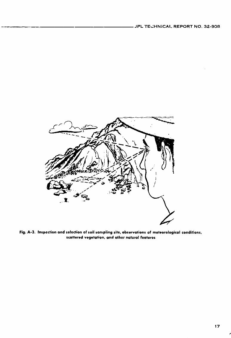
2. "Survey" suitable areas for possible sampling sites (Figs. A-2 and A-3).
3. Take photos of the area, and make notes on observations (see AppendixB; Figs. B-I-B-5).
4. Inspect and select suitable soil site. Take additional photos of pertinentarea and site features, and record observations (Fig. A-3).
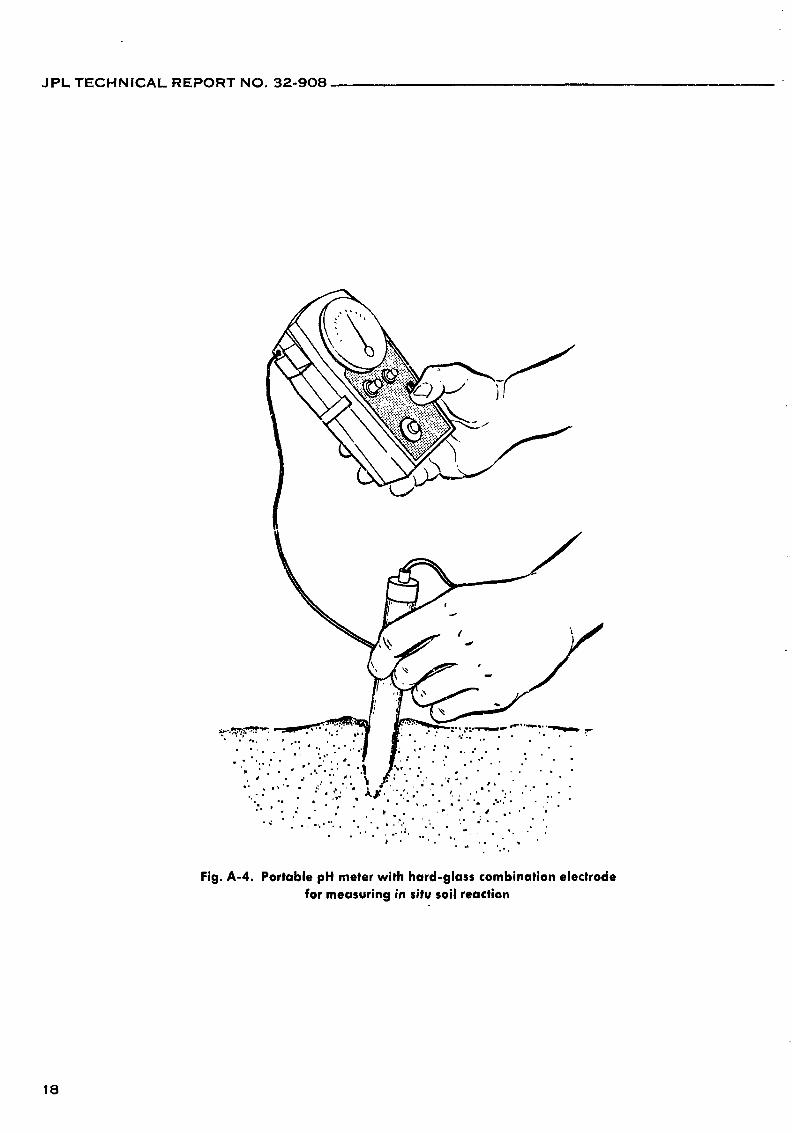
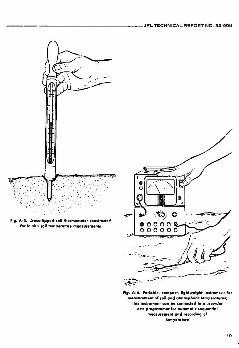
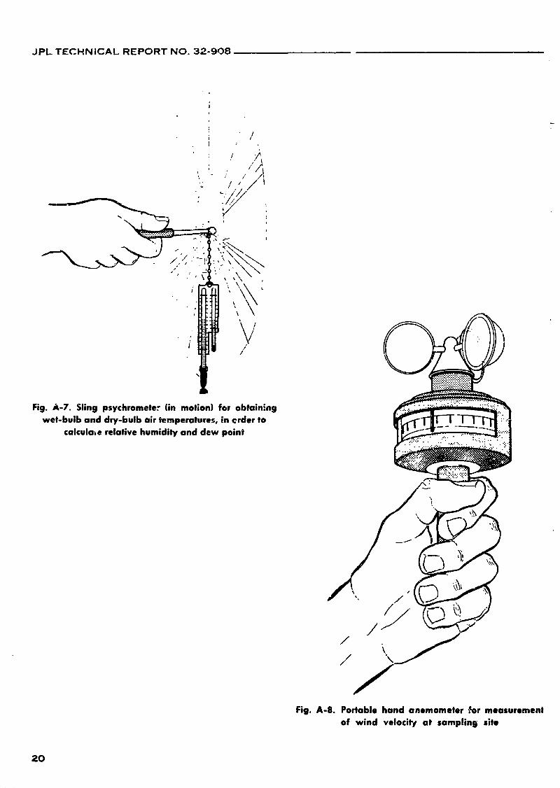
5. Make pertinent environmental and in situ soil observations and measure-ments (Figs. A-4-A-9).
6. Prepare and arrange equipment for soil sampling operations (Figs. A-l,A-10, and A-11).
7. Make sign for identification purposes (Fig. A-12).
8. Sterilize and cool/rinse soft samplers, digging devices, etc. (Fig. A-10).Adequately label soil sample containers (Fig. A-11).
9. Collect soil surface samples from depth of a few cm (Fig. A-12).
10. Collect corresponding soft moisture tin samples (Figs. A-1G, A-13, and A-14).Be sure that all soil moisture tin samples are adequately packaged andlabeled (Fig. A-11).
11. Repeat sterilization, cooling, and sampling procedures, so as to obtain soilsample units from deeper depths of soil "profile." Take samples from levelsof 1--6 in., 1 ft, 2 ft, 3 ft, but not more than 3 ft in depth, unless other-wise desired (Fig. A-12). Do not contaminate deeper layers of soil withsurface materials.
12. Store collected samples in protected area, e.g., under vehicle, away fromdirect sunlight and heat.
13. Following the collection of soil samples, take additional photos of thesampling site showing exposed so,l "profile" and vertically placed meterstick and identification sign in position (Fig. A-12).
14. Make final notes, and indicate location of sampling site on map (Fig. A-15).
15. Collect and check all samples and equipment (Fig. A-l). Leave the areaand sampling site in as good condition as possible, and remove all discardedmaterials, trash, etc.
lt_ Attach address labels, and also import form, if necessary (Fig. A-16). Trans-port and ship soil samples to the Laboratory. Notify pertinent Agencies andpersonnel in regard to shipment of samples.
15
1966014571-018

JPL TECHNICAL REPORT NO. 32-908
Fig. A-1. Four-wheel drive vehicle and miscellaneous field equipment laid outfor inspection prior to departure to desert areas
16
1966014571-019
JPL TECHNICAl. REPORT NO. 32-908
Fig. A-3. Inspection and selection of soil sampling site, observations of meteorological conditions,scattered vegetation, and other natural features
17
1966014571-020
JPL TECHNICAL REPORT NO. 32-908
18
1966014571-021
JPL TECHNICAL .REPORT NO. 32-g08
19
s'
1966014571-022
JPL TECHNICAL REPORT NO. 32-908
Fig. /4-7. Sling psychrometer (in motion) for obtaln'ngwet-bulb and dry-bulb air temperatures, in ©rder to
calculale relative humidity and dew point
/ / C5/ _ _i
Fig. A-8. Portable hand anemometer _r measurement
of wind velocil'# at sampling site
20
1966014571-023
JPL TECHNICAL REPORT NO. 32-908
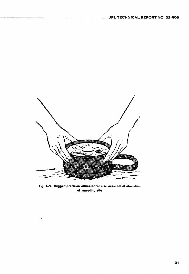
Fig. A-9. Rugged precision altimeter for measurement of elevationof sampling site
21
1966014571-024
JPL TECHNIC.-_.L REPORT NO. 32-908
i
,i' _ __
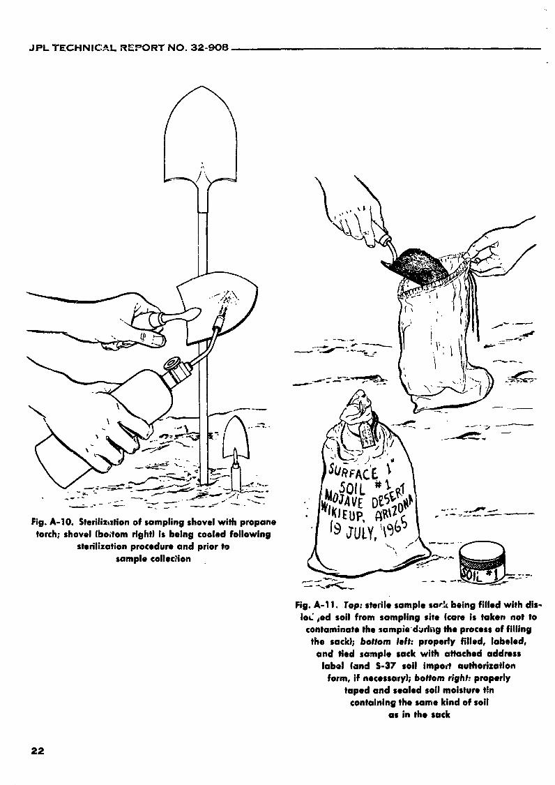
Fig. A-|O. Steriliz,ztion of sampling shovelwilh propane " [9 _ULy2i_('_/_
torch; shovel (bo,_om right) is being cooled following
sterilization procedure and priortOsamplecollec_ion .___ ___-_ "_
Fig. A-11. Top: stedle sample sar_ being filled with dis-IoC ,ed soil from sampling site (care is taken not to
contaminate the samp;e'd_ring the process of fillingthe sack); bottom left: properly filled, labeled,
and tied sample sack with attached addresslabel (and S-37 soil impo_t authorization
form, if necessary); bottom right: properlytaped and sealed soil moisture tin
containing the same kind of soilas in the sack
22
1966014571-025
JPL TECHNICAL REPORT NO. 32-908
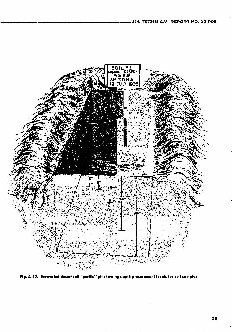
_GTAVF-DESERT "WIKIEUP I
ARIZONA IIg JULY19651
po
23
f
1966014571-026

JPL TECHNICAL REPORT NO. 32-908
24
1966014571-027
JPL TECHNICAL REPORT NO. 32-908
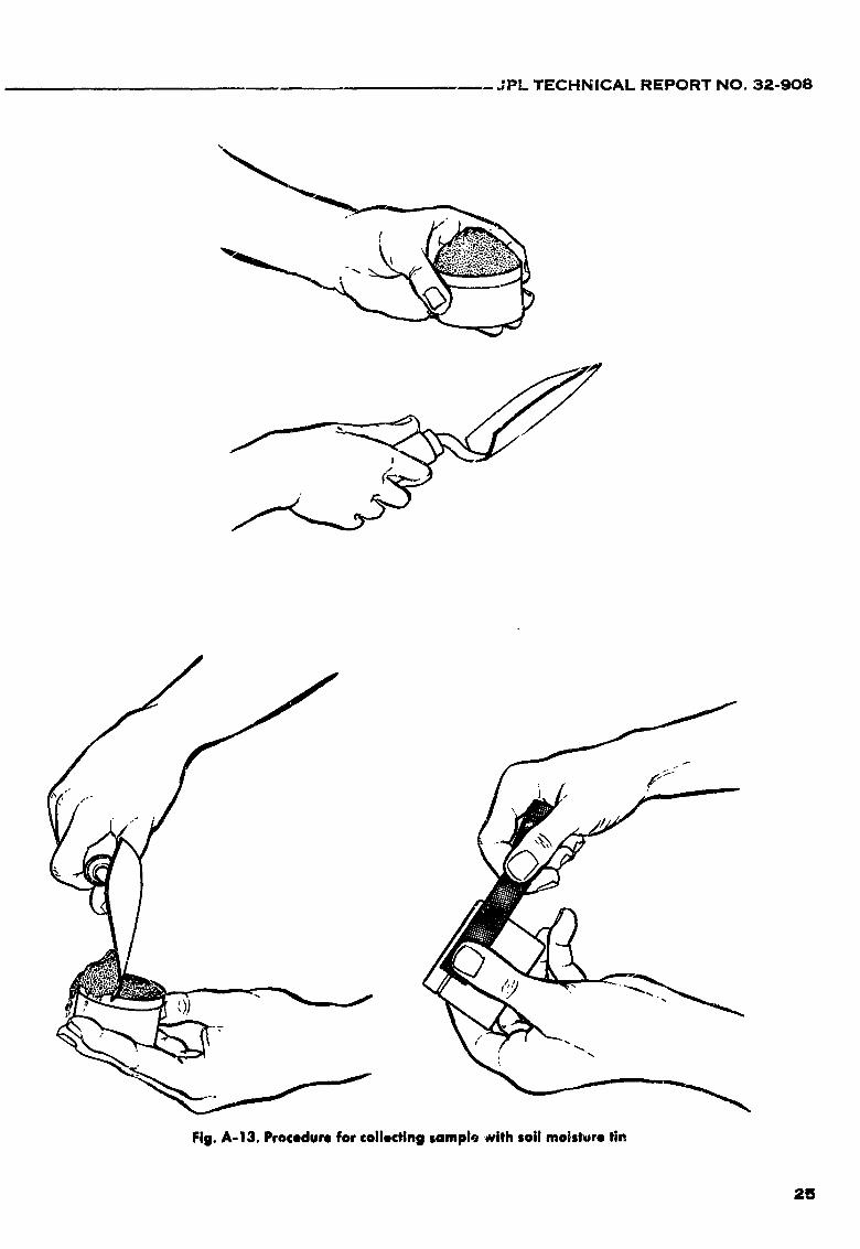
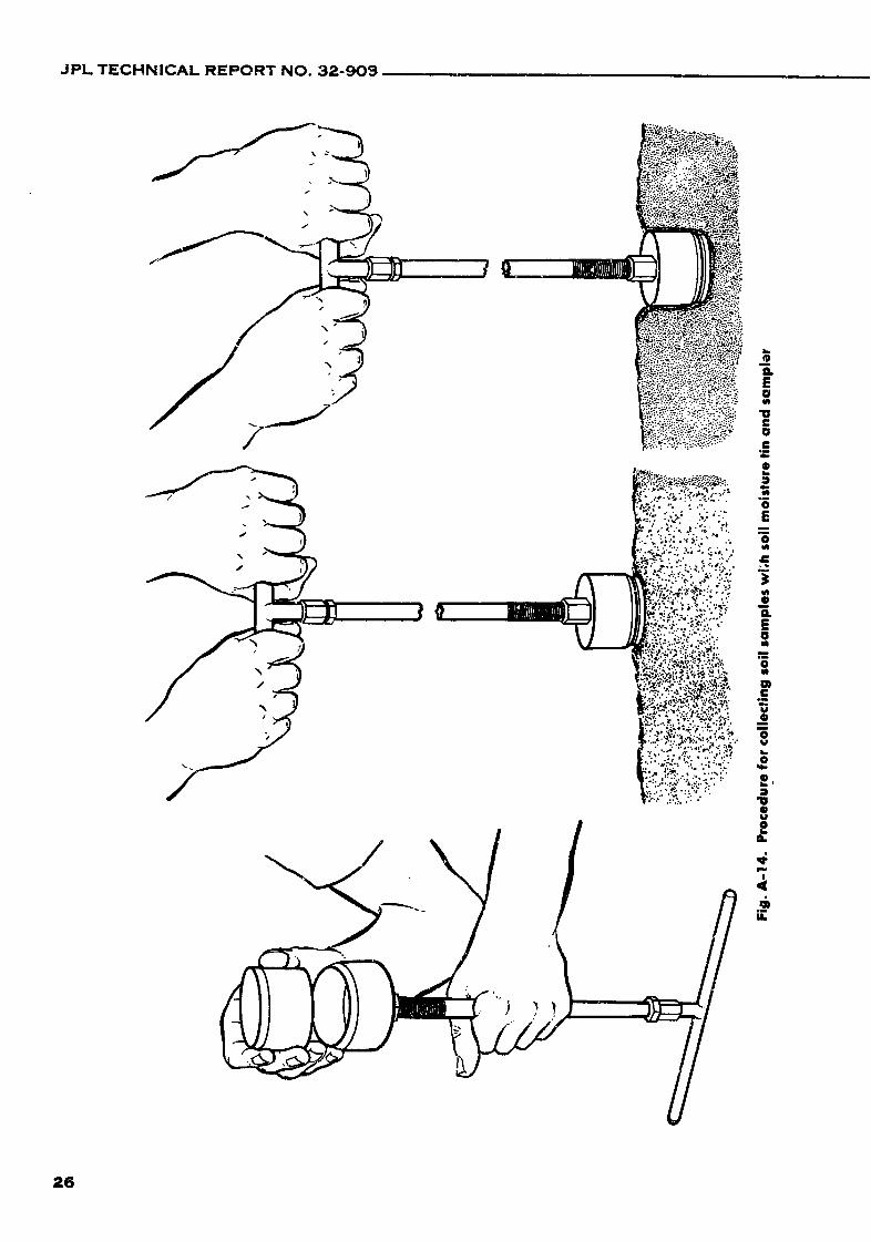
Fig. A-13. Procedurefor collectingsamplr_with soil moisture tin
Z5
1966014571-028
JPL TECHNICAL REPORT NO. 32-909
26
1966014571-029

JPL TECHNICAL REPORT NO. 32-308
Fig. A-15. Locatingsoil sampling site on map for
future reference TO: JETPROPULSIONLABORATORY
CALIFORNIA INSTITUTE OF TECHNOLOGY
4800 Oak Grove Drive PouNIlena_ Celif_'nio
ATTEN: DR. ROY CAMERON
SOIL SCIENCE LABORATORYBUILDING 77
U. 8. O[PARTMIrNlr OF AGRICUI.TuIqlAGmCULTUIqA¢. RIrmRAIICM IIQRVI¢I[
IBILA41iTq_AR&NTINi OIVIJIONWJMN41NI'rON ill D. CS-37 ' •
IMPOaTATION AUTNORIZIID
llaterild ecllmlmd in dis pscksle is _
20.1912.- ,,,,d,¢ (, _''_;_VTide plbekue coms_m SOIL SAMPLES FuR RILfLASI
, PQ Peru 21C _ PIE _" JIly 1940
Fig, A-16. Top: addr_.s label for shipment of soilsamples to JPL Soil Science Laboratory;
bottom: U.S.D.A. S-37 form for soil
impodation authorizatien
27
1966014571-030

JPL TECHNICAL REPORT NO, 32-908
APPENDIX B
Soil Sample Information Sheet and Accompanying Photographs
Photographs of site, area, soil surface, and exposed Soil Nos. 14-16 at WhiteMt. Summit (elev. 14,245 It), Whit,_ Mr. Research Station, White Mt. Range:Inyo National Forest, California, are given in Figs. B-l-B-4. Figure B-5 shows a
Soil Sample Information Sheet for this location.
Fig. B-1. Frozen loessial soil beneath and between 4, _- _."rough stonesat summitsoil site ":'_'_
4 ,;
Fig. B-2. Algal-lichen growth on soil, and colorfulcrustoselichenson rocks;soil crustssubject
to diurnal freeze-thaw cy¢los
28
1966014571-031

JPL TECHNICAL REPORT NO. 32-908
(,
,/i
v
Fig. B-3. View toward Nevada and surrounding ':_'"mountain peaks as seen from soil site
at White Mt. S,Jmmit
R'
*2 '
•Fig. B-4. Collectingsurface soil crustsfrom patch of
soil between rocks; rocky windbreak at dght
29
1966014571-032
JPL TECHNICAL REPORT NO. 32-908
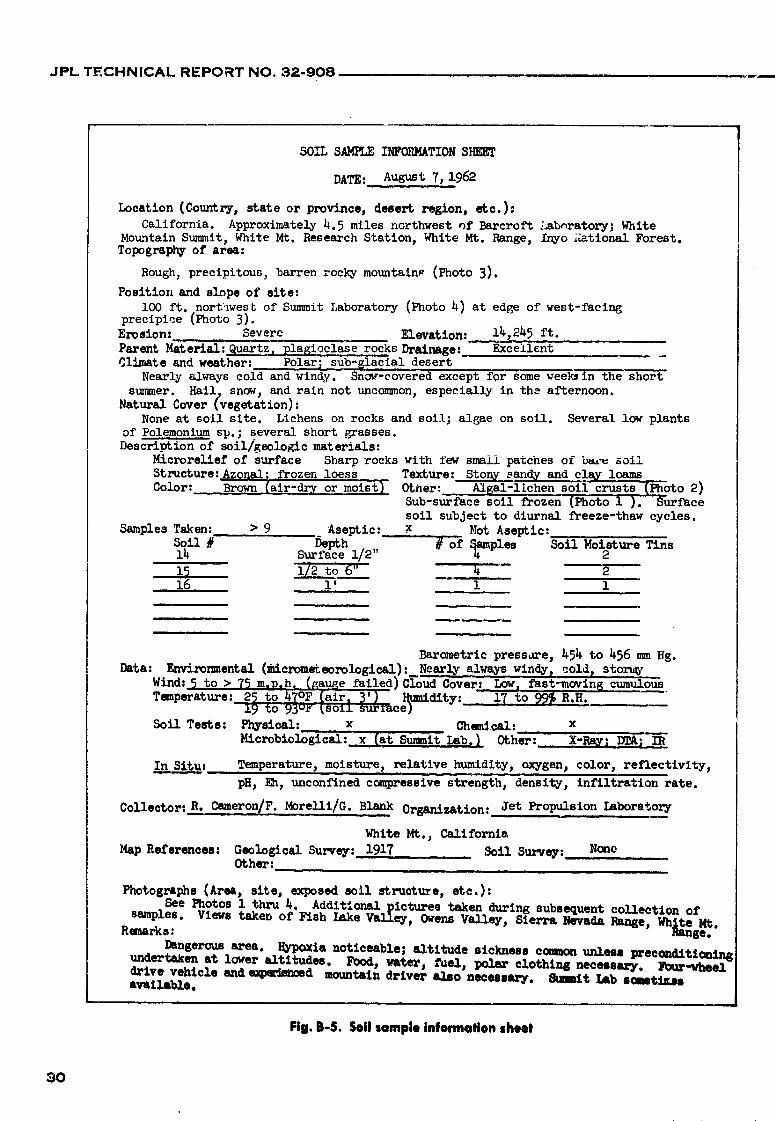
SOIL SAMPLE INFORMATIONSHEEr
DATE: August 7,1962
Location (Country, state or province, desert region, etc.):California. Approximately4.5 miles northwest of Barcroft Labnratory; White
Mountain Summit, White Mt. Research Station, White Mt. Range, /nyo _;ationalForest.Topography of area:
Rough, precipitous,barren rocky mountains (Photo 3).
Position and slope of site:i00 ft. northwest of Summit 1_boratory (Photo)4)at edge of west-facing
precipice (Photo 3).Erosion: Severe Elevation: 14,245 ft.
Parent Material:Quartz. plagioclaserocksDrainage: Excellent m
Climate and weather: Polar; sub-glaclaldesertNearly always cold and windy. Snag-coveredex6ep_ for some weeksin the short
smmner. Hail. snow, and rain not uncommon, especially in the afternoon.Natural Cover (vegetation):
None at soil site. Lichens on rocks and soil; algae on soil. Several low plantsof Polemonium sp.; several short grasses.Descriptionof soil/geologicmaterials:
Microreliefof surface Sharp rocks with few small patches of b_.'u_oli
Structure:Azonal: ,;_'rozenloess Text_Are:Ston_ sand_ and _cla_loamsColor: Brown (air-dry ormoist_ Other: Alsal-lichen soll crusts _l_oto 2)
Sub-surfacesoil frozen (Photo i ). Surfacesoil subject to diurnal freeze-thawcycles.
Samples Taken: > 9 Aseptic: x Not Aseptic:Soil # Depth # of Samples Soil Moisture Tins14 Surface 1/2" _ " 2
i_ 1/2 to 6" 4 216 I' i i
Barometric pressare, _54 to _56 mm Hg.
Data: Environmental (micrometeorological):Nearly always windyt cold, stor_Wind: 5 to > 75 m.D.h_ (gauge failed)C_oudbov'er: Low_ fast-movin6 cumulousTemperature: 25 to _7OF (air, _') _umidity: 17 to 99_ R.H.
19 to 93u_"_soIA surface) .....
Soil Tests: Physical: x Chemical: x
Microbiological:x(at Summi¢ Lab.J Other: X-Ray: IEA} IR
In Sit.._._._uu:Temperature,moisture, relative humidity, oxygen_ color, reflectlvity,
pH, _, unconfined compressivestrength, density, infiltrationrate.
Collector:R. Cameron/F.Morelli/G. Blank Organization: Jet Propulsion Laboratory
White Mt._ Callfornia
Map References: Geological Survey: 1917 Soil Survey: No_eOther:
Photographs(Area, site, exposed soil structure,etc.):
See Photos i thru 4._ Addit_o_._l__icturestaken during subsequent collection of
samples. Views _axen or _sn AaKe vaJ_l.ey, Owens Valley, Sierra Nevada Range, Wh_geMt oRemarks:
Dangerous area. Rypoxia noticeable; altitude eickneee ccemon unleu preconditi_ingunderte_en at lower altitudes. Food, water_ f_el, _ clothing necessary. Four-wheeldrive vehicle and e_pa_ed mountain driver also neceeeary. Stmmit I£b ecemti_mavailable.
Fig. B-5. Soil sample information sheet
3O
1966014571-033
JPL TECHNICAL REPORT NO. 32-908
APPENDIX C
Suggested Minimum Equipment List for Soil Sample Collecting
1. Transportation vehicle adequately inspected and equipped prior to field de-parture (Fig. A-l). A four-wheel drive vehicle is preferable. Include spare tires,extra gasoline, oil, stout rope, some baling wire, an axe, vehicle tools, emer-gency Hares, and all other usual vehicle equipment.
2. Cameras (preferably two). Take one camera for black and white film and asecond for color negatives _c color slides. Also include light meter, flash unit,and clese-up lenses, ff available. Fih,, should not be high-speed, and shouldbe adequately protected in tins or sacks.
3. Meter stick and/or other measuring device, clipboard, and paper for identi-fication sign (Fig. A-12).
4. qterilized, plastic-lined, canvas sample sacks (Fig. A-11), or other st_cile samplecontainers." Include a minimum of five sample sacks per soil sampling siteof approxirnatt ly 1 meter depth. Cement sacks or large burlap bags can beused to hold several ---" ...... Io sack_III_,L[_I o tit 11 l_./.I._.s ,
5. Soil moisture tins (at least the same q,mntity as sample sacks) (Figs. A-13a-A-13g). Use soil moisture tin sampler ff avaib, ble (Figs. A-14a-A-14c). Includemoistureproof tape (Fig. A-13g) znd knife.
6. Address labels, twine, and S-37 soi! importation authorization permits, ifnecessary (Fig. A-16).
7. Soil samplers and dig_'ng tools: sterilizable, small and large shovels (Figs.A-1 and A-10), geological hammer with pick head (Fig. A-l), large pick,
mattock, crowbar, and other digging and sampiic.g equipment.
8. Sterilizing equipment such as propane torch (Fij. A-10) or portable campstove, and sttflicient fuel supply.
9. Moistureproof, felt-Up marking pens, other pens, pencils, ruler, and notebooks.
10. Miscellaneous tools, e.g., pliers, wire-cutter, hammer, wrenches, tongs, etc.
11. Maps (Fig. A-15) (especially topographic), watcll, stop watch, steel measuringtape, and pace counter.
12. Flashlights, "radarlights," and sufficient batteries, or lamps and fuel (Fig. A-l).
13. Various instruments for environmental and soil site measurements: thermora-
eters (Figs. A-5 and A-6), sling psychrometer (Fig. A-7), small pH meter
(Fig. A-4), hand anemometer (Fig. A-8), soil color charts, clinometer, PaulinAltimeter (Fig. A-9), aneroid barometer, etc. Also include sufficient distilledwater supply in sturdy, rustproof contair.ers (Fig. A-l).
14. Various personal items: include here such items as food, water, appropriateclothing (especially a hat), chapstiek, sunburn lot,:on, sun glasses, shop towels,a first aid kit (include snake bite kit), a desert survival manual, gun and
*Soilmor_'umtins (approx. $1.20/doz.) and sample _cks, plastic-linfd (approx. $1/sack), _:,well as many other Reins of soil equipment are available from Soiltest, Inc., 2205 Lee St.,Evanston, Illinois.
31
1966014571-034
JPL TECHNICAL REPORT NO. 32-908
ammunir;on, eating and washing utensils, soap and pans, knife and hatchet,knapsack ground-cover, sleeping bag, camp stool and table, etc. It is highlysuggested that at least two persons in good physical condition should bechosen for desert field trips. Keep people informed of your movements, andthe time you expect to sperd in remote areas. Be adequately prepered fordesert field trips into rough, remote areas. Various diffculties for personneland eqtfipment are encountered and are not uncommon.
APPENDIX D
Nomenclature
adobe-a structural term applied to soils which form deep activity., or conditions of parent material, relief olcracks and break into irregular, cuboidal or polygonal drainage, that prevent the development of typical soilblocks upon dryiLg. . profile characteristics. See aridisoLs and ent/so/s.
algal-lichen soil erust-a soil crust formed on the surface badland-nearly or partly barren, rough, broken land
of arid aa:d semiarid soils which can be more or less sL-'ongly dissected by .streams or drainage channels.easily separat_-_l from the sairfaee of the soil and con- They are most common in arid and semiarid regions,tains algae in variotls stages of pa_asitization or licheni- where water has cut channels through soft geologicration by fungi. See s_l crust, materi.,ds such as clays and soft shales, and including
alkali soil-genexally, a highly .alkaline soil containing a less weather resistant sandstones and limestones.
high percentage of available sodium, black alkali-a term applied to alkali soils containing a
allu,Aal soils (entisols or secondary ._oils)-an azonal preponderance of very toxic sodium carbonate andgroup of soils, developed from transported and rela- sodium chloride salts. The black color is commonly duetively recently deposited material (alluvium) character- te dissolved and dispersed organic matter.
ized by a weak mod_cation (or none) of the orginal calcareous soil-a soil which contains a significant amountmaterial by so_.l-forming processes, of carbonates (usually CaCOs) and effervesces when
alluvium-fine material, such as sand, mud, or other tested with weak (0.1N)HCI.sedimentx deposited on land by streams.
ealiche-a more or less cemented deposit of calcium car-arid climate-(a) a dry climate characteristic of hot, cold bonate (CaCO.0 or of mixed calcium and magnesium
or temperate desert and semidesert regions ir_ which carbonates (MgCO_,), characteristSc of soils of desertprecipitation effectiveness, water availability, or evapo- and semiarid regions which lack sufficient leachingration rate are such that a sparse vegetation of desert rainfall.plants can exist or _he land is barren, (b) a climatewhere the limits of precipitation vary widely according eemente.tion-a process whereby soil becomes hard andto temperature, with an upper limit for cool regions of dense through the accumulation of minerals such as< 10 in., and for tropical regions of as much as 20 in. silica, iron, manganese, salts, e.g., calcium and magne-
sium carbonates, and clay.aridisols-soils of dry places, commonly light-colored,
mineral soils which are low in oiganic matter and either day-(a) a soil separate consisting of particles of 0.002lack or have weak diagnostic horizons. These soils are mm or less in equivalent. (b) a soil textural class, (c)common in arid and semiarid lands lacking a favorable soil material that contains 40$ or more clay, < 45tmoisture-temperature regime and dependent biota, sand, and < 40'$ silt.
azonal soils-any group of soils la,'king well-developed elaypan-a hard, dense soil layer underlying the soilprofile characteristics, either because of their youth surface. It is especially hard when dry, and it is plastic(short geologic time period), arid climate, lack of biotic or stiff when wet. Also called hardpan.
32
1966014571-035

JPL TECHNICAL REPORT NO. 32-908
coneretion--a nodular or inegular concentration of sedi- dune-a mound or ridge of loose material, usuaUy sand,mentary rocks and tufts. It is developed by the localized which has been piled up by the wind.
deposition of material from solution, generally around ecosystem-the biotic community, including all the com-a central nucleus, and can be found as a weather-ponent organisms together with the abiotic environ-
resistant body in some soils, e.g., lime concretion.ment, forming an interacting svstem.
consolidated soil material-soil material made solid by edaphie-(a) of or pertaining to the soil, (b) resulting fromcementation or otLer processes, from a previous fluid or influenced by factors inl_,erent in the soil or otheror loosely aggregated c-.ndition, substrate, rather than by cl;matic factors.
crustose- resembling a crust, or incrustation. A hardened entisols-see alluvial soils.external layer which is found in certain soil and rock
lichens, especially in arid and semiarid regions, environment-all external conditions that mav act uponan organism or soil and which influence its develop-decalcified soil-a sod which has had the calcium car-ment.
bonate removed from the soil by leaching.
deep sod-generally, a soil that has a depth greater than erosion--(a) the wearing away of the land surface bv run-1 meter to rock or other strongly contrastiag material ning water, wind, ice, or other geologic agents, includ-
ing gravity, (b) detachment and movement of soil ordegraded soil-a change of one kind of soil into a more rock by water, wind, ice, or gravity•
highly leacl-.ed one.escarpment-a steep face abruptly terminating h.lgh lands
dehiscence-(a) the bursting of certain dry" fruits ator frequently presented by the abn_pt termination of
maturity, (b) the opening and discharge of pollen from stratified rocks.the anther (sac-like organ on seed-producing plants),(c) the unfurling of leaves, evapotranspiration--the loss of water from a soil by
desalinized soil-a soil which has had salts, especially evaporation and plant transpiration.
sodium compounds, removed by leaching, flaccid cacti-weak or limp cacti (various plants of the
desert, erust-a hardpan, claypan, caliche layer or other cactus family), which exhibit signs of water !os_ nrbinding material ..'xposed at the soil-atmosphere inter- desicca3on of plant parts.
face in desert regions, flocculated soil-a soil which has the individual grains ordesert pavement-a pebbly, stoney, rocky, or similar sur- particles aggregated into small groups or granules.
face layer of coarse material found in desert regions flood plain-the ne_r!y _a_ lands along streams or riversafter the removal of fine material• Materials are fre- that overflow during floods.quently smoothed and polished by wind erosion, and
browned or blackened when containing sufficient oxi- friable soil-soil that is easily crumbled in the fingers.
dized iron and manganese compot,nds, i.e., desert gently slopir, g land-land with an average slope varyingvarnish.between 3 and 8_.
desert soils-a group of soils which are azonal, intrazonal,
or zonal, found in hot, cold, or temperate regions, gley soil-a soil developed under conditions of poordrainage and resulting in reduction of iron and oi.-herfrequently light-colored, well-oxidized, sometimes con-elements and in gray colors and mottles. Uncommon intaining salt depos,.'ts, and developing under arid con-desert soils, except as a relict or in nonarid micr:)-ditions and scant or absent macrovegetation.environments.
desert varnish-a glossy sheen or coating on stones andgravel in desert regions. Also see desert pavement, hardpan-a hard, dense soil layer underlying the soil
surface. It is also synonymous with claypan or otherdispersed soil-(a) a soil which has had the compound cemented layers of soil such as caliche,
particles or aggregates broken up into the individualcomponent particles, such as by sodium in desert soils, humus-the well-decomposed, more or less stable part of(b) distributed or suspended fine particles, such as clay, organic matter in the soil which has lost its originr, lin or throughout a dispersion medium, such as water, structure and has not vet been reduced to simple end-
dry sands-an azonal group of soils consisting of well- products.
drai_aed relatively cohesionless sandy deposits in which impervious soil-a so;: througt_ which water, air, or roots
typical soil profile characteristics have not developed, penetrate slowly or not at all.
33
r'
1966014571-036

JPL TECHNICAL REPORT NO. 32-908,
influx-a gain of mattei or energy from outside assigned ditions, brought about by the modification of generalboundaries, such as an ecosystem, e.g., solar radiation, climatic conditions by local differences in elevationmoisture precipitation, or sedimentation of dust. and exposure.
inherited soil characteristic-any characteristic of soil that microrelief-minor surface configurations or small-scale,
is due directly to .the nature of the parent matecial as local differences in topography, including mounds,c_ntrasted to those partly or wholly due to the swales, or pits that are only a few centimeters to deci-processes of soil formation, meters in diameter and with • '_evation differences of
intr_zonal soiis--any group of soils with more or less severa', centimeters up to one or more meters.
well-developed soil characteristics that reflect the mineral soil-a general term used in reference to any
dominating influence of some local factor of relief, soil composed chiefly of m;neral matter; especiallyparent material, or age over the normal effect of the characteristic of arid and semia6d soils.
climate and vegetation, nodule-a small, more or less rounded body generallyKrotovina (crotovina)-a mineral accretion or deposit of somewhat harder than the enclosing soil, sediment, or
organic matter formed by the filling of a channelway or rock matrix.
former animal burrow. The burrow is usually found outflux-losses of matter or energy from within assignedfilled by material different from that of the soil sur- boundaries, such as an ecosystem, e.g., heat radiation,rounding it. water runoff, or solids carried off by erosion.
lacustrine deposit-material deposited in lake water and pans-horizons or layers of soil that are strongly com-later exposed either by lowering of the water level or pacted, indurated or very high in clay content. Seeby elevation of the land. caliche, cIaypan, and hardpan.
landforms-multitudinous natural features that taken parent material-the unconsolidated mass from which the
collectively make up the Earth's surface. These features soil profile develops.are characterized according to size, shape, angles ofslope and orientation, regardless of origin of develop- parent reek-the rock from which parent materials arement, e.g., hills, vaileys, mountains, canyons, playas, formed. See parent material.
alluvial fans, etc. pedologi,_t-a soil scientist, especially one who is con-
leached soil-soil fr(_m which the soluble salts have been eerned with the laws of origin, formation, and gee-
removed by the percolation of water through the soil. graphic distribution of the soil as a body in nature.
loam-soil material that contains 7 to 27_gclay, 28 to 50g peneplaln-a land surface reduced by erosion almost tosilt, :-md < 52_gsand. base ievel so that most of it is approximately a plain.
loess-material transported and deposited by wind and permafrost-(a) permanently frozen material underlyingconsisting of predominately silt-sized particles, the solum or upper and most weathered part of the
soil profile, (b) a pere,anially frozen soil.macrobiota-organisms visible by the naked eye and
which do not need a microscope for detection purposes, pledmont--lying or formed at the base of mountains. Apiedmont alluvial plain is formed by the coalescence
See macrove[_etation, of alluvial fans.macrovegetatlon-plants which are visible to the naked
eye and which do not need a microscope for detection plain-a large relief form or region of general uniformpurposes, e.g., shrubs, trees, grasses, and various flower- slope, comparatively level, of considerable extent, anding annuals and perennials, not broken by marked elevations or depressions.
mature soil-a soil with well-developed characteristics playa-(a) the shore, strand, beach or bank of river,produced by the natural processes of soil formation and generally sandy and sometimes salty, (b) the sballow
central basin of a desert plain, in which water gathersin equilibrium with the environment.after a rain and evaporates.
microcllmate-(a) the climate /demperature-moisture-gasregime and related hctors) ,;urrounding a single soil playa lake-broad, shallow sheets of water which quicklyparticle, bacterium, or population of microorganisms gather and a_most as quickly evaporate, leaving dry
or moist mud flats or playas to mark their sites.on a soil particle, (b) the climate :_,t the soil surface-
atmosphere interface exlending into the atmor.phere to pore space ( voids )-the total space not occupied by seilapproximately 1 meter or more, (c) local climatic con- particles in a .bulk volume of soil.
34
1966014571-037
JPL TECHNICAL REPORT NO. 32-908
relief-the elevations or inequalities of a land surface, soil bulk density (apparent density, volume weight )-the
considered collectively, mass or weight of oven-dry (105°C) soil per unit
rhlzosphere-that portion of the soil directly affected by volume, including pore space.plant roots, soil charaeteristic-a feature of a soil that can be observed
rolling land-land which has compound slopes of 9 to and/or measured and determined in the field or in the15_. laboratory on soil samples, e.g., texture, structure, iron
content, etc. Also see soil property.root zone-the part of the soil that is invaded by plant
roots, soil climate ( solclime)-the moisture and temperatureconditions existing in the soil.
rough broken land-land with very steep topography andsoil consistence-the relative mutual attraction of the
numerous intermittent drainage channels but com-monly covered by vegetation, particles in the whole soil mass or their resistance to
separation or deformation, e.g., friable, soft, hard,rubble land-land areas with 90g or more of the surface cemented, etc.
covered with stones and boulders.soil creep-the dowl,ward mass movement of sloping soil
runoff-that portion of the precipitation on an area which which is usually slow and irregular.is discharged from the area through stream channels.
soil erust-a brittle layer of hard soil formed on the sur-sallnization-the process of accumulation of salts in soil. face of many soils when dry.
salty soil-a generic term applied to soils having char- soil drainage-the rapidity and extent of removal of wateracteristics which are caused by exlmsure to excessive from the soil by runoff and flow through the soil toamounts of soluble salts, underground spaces.
sand-(a) a soil particle between 0.05 and 2.00 mm in soil fertility-the quality of a soil that enables it to pro-diar_aeter, (b) a soil textural class, (c) soil material that vide compounds in adequate amounts and in propercontains &Sg or more of sand; percentage of silt, plus balance, for the growth of specific plants, when other
1.5 times the percentage of clay, shall not exceed 15. growth factors such as light, moisture, temperature,sandy soil-a soil containing a large amount of sand. and the physical condition of the soil are favorable.
scabland-land characterized by numerous outcrops of soil genesis-the mode of origin of the soil, referringlava rock or scoria, and including land having numer- particularly to the processes responsible for the develop-ous spots of barren, salty soil as is found in arid and ment of the solum from the unconsolidated parentsemiarid regions, material.
second growth-new or continued growth by plants fol- soil horizon-a layer of soil or soil material approximatelylowing an interruption of the growth period by fire, parallel to the land surface and differing from adjacentflood, hail, drought, landslide, or animal damage, related layers by degrees of physical, physicochemical,
secondary soils-see alluvial soils, chemical and microbiotic properties.
soil kind-a collection of soils that are alike in specifiedsflt-(a) a soil separate consisting of particles between combinations of characteristics.
0.05 and 0.002 mm in equivalent diameter, (b) a soiltextural class, (c) soil material that contains 8(Ygor more soil map--a map showing the distribution of kinds of soilsilt and < 12g clay. or other soil mapping units in relation to the prominent
physical and cultural features of the Earth's surface.single grain.-e_ch grain in a soil considered by itself, as
in a structureless dune sand. soil microfauna-that part of the animal populationwithin and on the soil which consists of individuals too
soil-a naturally flefived body existing as a dynamic open small to be clearly distingaished without the use ofsystem. It is a product of ff_e environment, and on this a microscope. It includes primarily protozoa andplanet it is composed of subsystems of a physical, ,'._maiodes.
chemical, and biotic nature. It has been developed soil microflora-that part of the plant population withinunder the combined influences of climate, time, min- and on the soil which consists of individuals too smalleralogy, topography, and biota, as well as other factors.
to be clearly distinguished without the use of a micro-soil aggregate-a single mass or cluster of soil consisting scope. It includes primarily bacteria, actinomycetes.
of many soil part':cles held together, e.g., granule, fungi, and algae.
35
1966014571-038

JPL TECHNICAL REPORT NO. 32-908
soil monolith-r, mo_,nted specimen of a soil profile or soil texture-the relative proportions of the various groupsvertical exposure of soil taken from a cut .h. a bank or of individual soil grains.
from a soft pit dtyg in the _,:ld. solum-the upper part of the soil profile, above the parentsoil morphology-the physical constitution of the so;1 material, in which the processes o_ soil formation are ,
includbig the texture, structure, porosity, consistence, taking place.
and ccJor of the various soil horizons, their thickness, steep land-land having slopes ranging from 30 to 45_.and arrangement in the soil profile.
stone l{ne-a layer within the soil profile consisting ofsoil mottling-spots or blotches of different color or stones, commonly deposited by stone-carrying flood
shade.; of color in the soil interspersed with the waters.dominant color.
stratified-composed of, or arranged in, strata or layers,soil organic matter-materials in soil which are living, or as stratified alluvium. Those layers in soils that are
are derived from plants or animals, and in various produced by processes of soil formation are calledstages of decomposition, horizons, while those inherited from the soil material
soil population-the group of organisms that are indige- are called strata.
nous or normally live in the soil. structureless soil-a soil showing no observable aggre-seii porosity-the volume percentage of the total bulk of gation or no definite and orderly arrangement of
soil not occupied by solid particles, secondary soil particles or units along natural lines ofweakness.
soil productivity-an agricultural term for the present
capability of a kind of soil for producing a specified subsoil-(a) any part of the soil beneath the soil surface or
plant or sequence of plants under a defined set of below the immediate soil-atmosphere interface, (b)management practices, that part of the solum or upper part of the soil profile
soil profile-a vertical section of the soil through all its just above the parent material, in which the processeshorizons and extending into the parent material, of soil formation are taking place, i.e., in agriculture,
it is that part of the solum below plow depth (approxi-soil property-a term commonly used synoPymously with mately 12 in.).
soil characteristics, except in a broader sense, i.e., soil surface soft-(a) that part of the soil at the immediate soil-physical, chemical, or microbiological properties, atmosphere interface to a depth of several centimeters,
soil sclence-that science dealing with soils as a natural (b) agriculturally, it is that part of the arable soil com-body or resoltrce and the properties of soils for various monly stirred by tillage implements to an equivalentpurposes, depth of 5 to 8 in.
soil separates-mineral particles, "_ 2.0 mm in eq_aivale,t talus-fragments of rock and soil material collected at thediameter, ranging between specified size lirrJts. See foot of cliffs or steep slopes, chiefly as a result of gravi-clay, silt, and sand. tational forces.
terrace (geologieal)-a fiat or undulating plain, com-soil speeificity-a soil which is limited to particular setof characteristics or conditions, monly rather narrow and usually with a steep front,
commonly bordering existing or previous rivers, lakes,soil structure-the combination or arrangement of primary or seas.
soil particles into secondary particles, units or peds. till (glaeiPl)-a deposit of unstratified earth, sand, gravel,Secondary units may be, but usually are net, arrar_ged and boulders transported by glaciers.in the soil profile in such a manner as to give a distinc-tive characteristic pattern, transpiration-loss of water vapor from the leaves and
stems of living plants to the atmosphere.soil subhorizon-a horizon or distinctive layer of soil
occurring to some depth beneath the soil surface, transported soil materials-parent materials of soils thathave been moved from the place of their origin and
soil survey-the systematic examination, description, redeposited during the weathering process itself orclassification, and mapping of soils in an area. during some phase of that. process, and _,,.ch consist
of, or are weathered from, unconsolidated formations.soil textural banding-the: occurrence of a soil band or
separate denoted by its difference in texture from the tuff (tufa)-a rock composed of finer kinds of volcanicadjacent soil layers or horizons, detritus, usually more or less stratified and in various
36
1966014571-039
JPL TECHNICAL REPORT NO. 32-908
states of consolidation. In calcareous deposits (traver- cacti, shrubs, small flowering annual _md perennialtine), it may be referred to as "calcareous tufa." plants, crustose lichens, etc.
unconsolidated soll material-soil material in a form or xerophytic (xerophilous)-see xeric.state of loose aggregation.
young (immature) soil-Ca ) an imperfectly developed soilvery steep land-land or slopes of more than 455. in telTnS of soil characteristics and horizons, (b) a soilvoids-see pore space, having a profile with sl/ghtly compact subsoil horizons.
weathering-the physical and chemical disintegration and zonal soils-any group of soils having well-developed softdecomposition of rocks and minerals, characteristics that reflect the influence of the active
xeric (xerophytlc)-arid, or deficient in moisture. Vege- factors of soft genesis, especially climate and livingration characteristic of desert regions; thorny brush, organisms (p_narily vegetation).
37
1966014571-040