Embed Size (px)
Citation preview
8/9/2019 Bangladesh Land
http://slidepdf.com/reader/full/bangladesh-land 1/16
3.1.1 INTRODUCTION
Land is the basic natural resource that provides
habitat and sustenance for living organisms, as
well as being a major focus of economic activities.
Degradation of land refers to loss of its potential production capability as a result of degradat ion of
soil quality and also its loss for effective use. In
Bangladesh, the topsoil degrades due to natural
processes and human activities. The functional
capabilities of soil deteriorate from activities
related to agriculture, forestry, and industry. On
the other hand, urban sprawling and infrastructure
development cause loss of available land. Natural
events such as cyc lones and floods cause land
loss, and can also deteriorate functional
capabilities of soil. Soil degradation in the coastal
area results from unplanned land use, as well as
intrusion of saline water. Therefore, solving or
minimizing land degradation problems should be
based on multi-sectored, multi-layered, yet
integrated approaches.
The land degradation section of this report deals with
causes of land degradation, both in terms of
deterioration of soil quality and loss of land. It also
highlights state and impacts of degradation, along with
policy and program responses.
There are several issues related to land degradationthat intersect with other concerns. The most relevant
of these have been addressed in other chapters of the
report. For example, land related environmental
problems, particularly droughts and floods, have been
discussed under the Natural Disaster section. The
Biodiversity section addresses issues of shrinking
wetland in the dry season. The Water Pollution and
Scarcity section deals with lean water flow in the river
system and fluctuation of groundwater.
3.1.2 PRESSURES
There are many driving forces compelling people
in Bangladesh to over-exploit natural resources like
land. The main ones are the poverty with rapid
population growth, improper land use, absence of a
land use policy, and ineffective implementation of
existing laws and guidelines. Unplanned
agricultural practices, and encroachment on forest
areas for agriculture and settlements, also put
pressure on scarce land resources. Unplanned or
inadequate rural infrastructure development and the
growing demands of increasing urbanization arealso devouring productive land. The level of land
degradation and its extent vary seasonally and
yearly, by region, as well as the pressures on land
are not always the same either.
Natural processes that lead to land degradation in
Bangladesh can be considered part of the ongoing landformation process. The upliftment and deposition
processes that led particularly to formation of land in
the regions of Sylhet, Chittagong, Barind and
Madhupur continued during the period of the
Miocene, Pliocene and Pleistocene ages. Throughout
the Pleistocene time up to the present, the rivers have
been depositing heavy sediments to build up the
country’s flat alluvial plain, although the processes of
erosion and deposition have not been similar all along.
There are a few studies on recent sedimentation and
erosion that show these processes have been
aggravated by human interventions such as
encroachment for settlement and improper agricultural
practices.
Land degradations caused by nature are often balanced
by formations of new land. Deterioration of soil
quality and land loss due to human intervention may
not always be reversible.
If the pressures on land are considered in a region-
wise manner, the following picture emerges:
Land degradation in the Chittagong Hill Tracts (CHT)is occurring mainly due to rapid changes in
demographic patterns, development of roadways and
other physical infrastructure. Jhum cultivation, the
traditional community-based agricultural method
practiced by the indigenous people of the CHT, is one
of the major causes of land degradation. Degradation
of land in the hilly area has also occurred due to the
mobilization of defense regiment for peace keeping in
the CHT, which leads to destruction of forestland and
loss of land cover.
The Madhupur forest area has almost been denudeddue to deforestation and has further been aggravated
by many other factors such as its closeness to the
capital city, improvement of road communication
leading to displacement of population, urbanization
and industrialization. This land, a Pleistocene terrace,
is naturally raised and flood-free, therefore, it is
attractive for infrastructural development. The land in
the area has further been degraded by the development
activities related to building of the Jamuna
Multipurpose Bridge.
Land degradation in the Barind Tract is caused mainlydue to over exploitation of biomass from agricultural
LAND DEGRADATION
25
8/9/2019 Bangladesh Land
http://slidepdf.com/reader/full/bangladesh-land 2/16
lands and unscientific cultivation of HYV rice through
groundwater irrigation. The process has been
aggravated by irregular rainfall; and insignificant
water flow in the adjacent rivers that normally play a
vital role in replenishing soil fertility and recharging
groundwater.
Degradation of soil quality in the floodplains is mainlyattributed to improper use of chemical fertilizers and pesticides to boost agricultural production. Siltation inthe floodplains also contributes towards degradationof land due to flashflood and sediments accumulatedfrom riverbank erosion. Dispersed industrial growthand uncontrolled discharges of their untreated effluentin the nearby rivers deteriorate the quality of land andsoil.
Land degradation in the coastal areas of Bangladeshis a result of recurring cyclones and storm surges,which inundate the land. Practice of shrimpcultivation round the year is ultimately increasing
the salinity of the degraded soil. Intrusion of salinewater in the dry season is attributed to the low flowin the river system.
Human interference and waterborne action are the two
most important land degradation processes inBangladesh. Table 3.1.1 presents driving forces and
pressures, state, impacts related to land degradation
and responses to address the problems.
3.1.2.1 Human Activities
Improper Culti vation in H il l Slopes, Terr ace Land
and Piedmont Plains
Shifting cultivation on the hills, locally known as
“ Jhum”, is a common practice among the tribal
communities in the greater Chittagong Hill Tracts.
Traditionally Jhum cultivation is a slash-and-burn
process where a certain area is cleared and cultivated
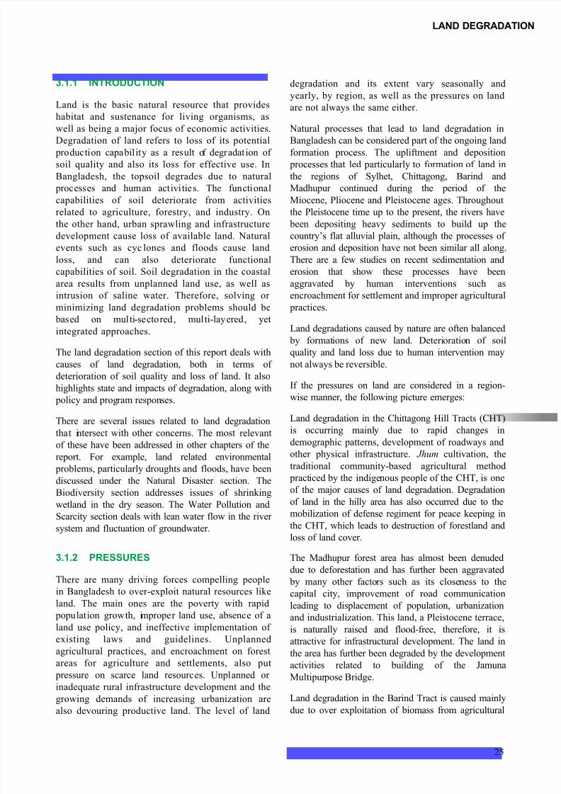
Source: SoE Study Team Note: E stands for Existing and P stands for Proposed
Driving Forces & Pressures State Impacts Responses
•Population and Poverty • Increasing population •Depletion of natural resource
base
•Population control and poverty
alleviation program. [E]
• Improper agricultural
practices
•Unscientific use of
agricultural inputs(chemical fertilizer and
pesticides)
•Yield reduction due to quality
degradation of soil and thusdecriseing land productivity
• Integrated Plant Nutrient System (IPNS)
• Integrated Pest Management (IPM). [E]
• Induction of green manuring crop,
biomass recycling. [E]
•Agriculture practices in
hill, terrace and piedmont area
•Deforested area •Loss of topsoil
•Gradual siltation in the
floodplain and water bodies
•Occasional restriction and ban of Jhum
cultivation [E]
•Massive afforestation [E]
•Adoption of SALT (Sloping
Agricultural Land Technology)
• Improper irrigation •Declining soil nutrient •Yield reduction due to quality
degradation of topsoil
• Irrigated Agricultural Development
Strategies [E]
•Use of surface water for irrigation [E]
•Development of rural
road network
• Increased length of road •Loss of productive agricultural
land
•Draft Land Use Policy [P]
• Integrated road, embankment and
drainage system
•Mining of sand and
gravel
•Abandoned area is
increasing
•Loss of productive land •Draft Land Use Policy [P]
•Land ownership and
tenure
•Land fragmentation •Quality degradation •Draft Land Use Policy [P]
•Riverbank erosion and
sedimentation
•Erosion and accretion of
land
•Loss of land and quality
degradation
•Riverbank protection and embankment
[E]
•Salinity • Salinity intrusion •Quality degradation •Augmentation of dry season flow [E/P]
• Industrial pollution •Open discharge to land •Quality degradation •Environment Protection Act and Rules
(95/97) [E]
•Rural housing •Horizontal expansion of • Seizing of productive land •Vertical expansion of rural housing [P]
•Urbanization • Increased unplanned land
use
•Loss of land •Draft Land Use Policy [P]
•Brick making and kiln • Number of brick kilns are
increasing
•Loss of topsoil
•Destruction of productive land
•Draft Land Use Policy [P]
•Environment Protection Act and Rules(95/97) [E]
Table 3.1.1 Pressures, State, Impacts and Responses of Land Degradation
26
BANGLADESH : STATE OF THE ENVIRONMENT 2001
8/9/2019 Bangladesh Land
http://slidepdf.com/reader/full/bangladesh-land 3/16
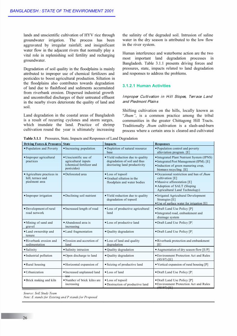
Clearing of natural vegetation for cultivation of
pineapple, ginger and turmeric along the slopes has an
ill effect, which increases soil erosion in the Sylhet
and in the hilly areas of Chittagong. These lands after
5-7 years of cultivation by this method totally degrade
to an almost irreversible state, to the extent that it
becomes practically unfit for further generations.
Rubber plantations on more than 70 per cent of the
slopes of Sylhet and Chittagong hills, leads to severe
landslides during the heavy monsoon period.
The population pressure and scarcity of agricultural
land has caused a heavy influx of settlers from
the plainlands to the unprotected forestlands of
Madhupur and Barind tracts and also to the
northern piedmont plains. The topsoil of all
these areas is either laid over infertile loamy
soils of shallow depth or over heavy compact
clays. Clearing of forestland for settlements and
unscientific land management for agricultural
use accelerate erosion of the topsoil with the
runoff from high monsoon rain. In addition, the
infertile heavy compact clay is exposed to the
surface as a result of the removal of topsoil.
Faulty I rri gation
The availability of irrigation water can be a blessing or a curse depending upon how it is
fo r 1-2 years, and then abandoned for 5-12 years
until the natural fertility of the soil is regained to a
useful economic level (Rahman, 1991). In the recent
years this traditional agricultural practice is
considered as the most inefficient way of using the
rich forest lands. Due to increase in the number of
population in the CHT region there is a demand on
agricultural production, which is putting pressure on
cultivable land. As a result, the traditional
regeneration time is not being allowed, and the soil
is loosing its fertility.
used. During the Fourth Five Year Plan (FFYP,
1990-94) a tremendous increase was made in the
installation of Shallow Tubewells (STWs) and Deep
Tubewells (DTWs) for groundwater irrigation. Most
of this irrigation water is being used on relatively
impermeable highlands of piedmont plain, meander
floodplain and in terrace areas. A very small area is
being irrigated in the haor basins by this irrigation
system. In the highlands, the cropping pattern is
mostly transplanted HYV Boro/Aus followed by
rain-fed transplanted Aman, but in the basins
broadcast Aman is grown followed the HYV Boro/
Aus varieties. As a result of this irrigation, the land
remains inundated in most of the seasons, which
keeps an adverse effect on soils because of
continued oxygen deprivation in the sub-soils.
Chemical changes of soil material forming toxiccompounds for plants and constant percolation loss
of essential nutrient elements including
micronutrients and organic matter.
Imbalanced Ferti li zer Use
The use of chemical fertilizers is directly linked to
farming in irrigated lands. Three types of fertilizers
such as Urea, Triple Supper Phosphate (TSP) and
Muriate of Potash (MP) and four types of pesticides
are commonly use in Bangladesh, which are
insecticides, herbicides, fungicides, and rodenticides.
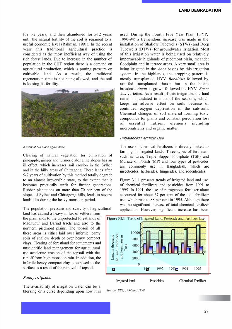
Figure 3.1.1 presents trends of irrigated land and use
of chemical fertilizers and pesticides from 1991 to
1995. In 1991, the use of nitrogenous fertilizer alone
accounted for about 67 per cent of the total fertilizer
use, which rose to 88 per cent in 1995. Although there
was no significant increase of total chemical fertilizer
application. However, significant increase has been
A view of hi ll slope agricultu re
0
2000
4000
6000
8000
10000
L a n d i n t h o u s a n d
h a . . a n d P e s t i c i d e s
a n d F e r t i l i z e r i n
T o n s
1991 1992 1993 1994 1995
Irrigated land Pesticides Chemical Fertilizer
Figure 3.1.1 Trend of Irrigated Land, Pesticide and Fertilizer Use
Source: BBS, 1994 and 1998
LAND DEGRADATION
27
8/9/2019 Bangladesh Land
http://slidepdf.com/reader/full/bangladesh-land 4/16
observed in use of pesticides, which has serious
implication to quality of land and ecosystem.
Ploughpan
Transplanted rice covers the widest cultivatedareas of Bangladesh, and is grown on medium
highlands and medium lowlands. The soils are
puddled in a wet condit ion for easy transplantation
and to prevent percolation loss, but this destroys
the soil structure. As a result of ploughing in wet
condition, a compact 3-5 cm ploughpan is formed
from the pressure of the plough, as well as from
the pressure during the transplantation of seedlings
(Rahman, 1991). This ploughpan impedes soil
drainage, restricts root penetration to deeper levels
and the movement of soil moisture from subsoil to
the topsoil during the dry season. The resultant
loss of soil structure makes the topsoil water
resistant and hard, which makes tillage difficult
and often makes it unfit for cultivating Rabi crops.
Some people argue that if this compacted
ploughpan method is not used, transplantation of
rice will be affected, but this has not been shown
to be true except in the shallow valleys of
Madhupur and Barind tract.
Improper Use of Pesticides
Farmers of Bangladesh are using pesticides since
1957 and at present on an average of 12-15
thousand tons of pesticides is used every year.
Insecticide accounts for about 90 per cent of the
total consumed pesticide, and is used most for
cultivating vegetables and Rabi crops (BBS, 1984
and 1998). Although pesticides are used at low
levels still they are a cause of land degradation. The
pesticides sprayed over standing crops ultimately
contaminate the surrounding soil. Research findings
show that pesticides applied at the rate of about one
kilogram per hectare contaminates the topsoil to adepth of about 30 cm. The pesticides not only
destroy harmful insects, but also destroy useful
topsoil microbes, which eventually reduce the
biological nutrient replenishment of the soil.
Over Exploitation of Biomass from the Agricul tural
Fields
One of the most important causes of land
degradation specifically in the Barind tract, is over
exploitation of biomass from cultivated fields (Hunt,
1984). The acute energy crisis in various areas leadsto all available vegetation being scavenged for
firewood and fodder. Due to the reduction of
vegetative cover from this withdrawal of biomass
silty loam topsoil over low permeability compact
heavy clay is lost and topsoil gets inadequate water
conservation capability. Therefore, there is
considerable runoff due to heavy rainfall during the
monsoon. This process of land degradation is also
common in other highland and medium highland
areas.
Unplanned Rura l In f ras t ruc ture (Road,
Embankment, FCD/I )
The rural roadways of the country have been
constructed under Upazila or District programs
through Upazila or Union Parishads (local level
government). Therefore, the road alignment was
subject to the influence of local politicians and
influential people. A noteworthy feature of this
alignment is that it follows the boundaries separating
agricultural lands, rather than cutting through them.
As a result, the actual length of the roads is often
much longer than needed.
A significant part of the roadways constructed
under the rural road network program fall within
the floodplain, with a view to easy road
communication during the monsoon season
between village to village, villages to markets and
villages to some industrial units. Therefore, the
road heights had to be kept above flood level, for
which a significant portion of agricultural land was
acquired for the roadway and the borrow pits along
the sides of the roads.
The main objectives of the development of flood
control drainage and irrigation are to reduce flood
hazard, facilitate agricultural productivity and the
livelihood of rural households. The impacts of
flood control, drainage and irr igation
infrastructures have been given in detail in the
Biodiversity section.
Urbanization
Urban development is necessary for economic
growth, but the present process of urbanization in
Bangladesh invariably reduces the amount of good
agricultural land. Dhaka city has been growing at the
expense of what were dense jackfruit and mango
orchards in Savar, Gulshan, Banani and Uttara areas.
The expansion of Khulna is reducing the coconut
plantations of Phultala and Abhayanagar. These
lands were not only good for horticulture, but alsofor Aus, Transplanted Aman, sugarcane and all kinds
of dry land crops. The rapid urban growth of the past
28
BANGLADESH : STATE OF THE ENVIRONMENT 2001
8/9/2019 Bangladesh Land
http://slidepdf.com/reader/full/bangladesh-land 5/16
two decades has mainly affected potentially triple
croppable highlands.
Br ickf ields and Biomass Use
Brick making is a dry season activity that can bestarted as soon as the monsoon rain stops.
Unfortunately, brick kilns are mostly situated on good
agricultural land as brick manufacture needs silty clay
loam to silty clay soils with good drainage conditions,
which is turning good agricultural land into
unproductive lands. Brick kilns are spread all over the
country, and are degrading land. Moreover, over 50
per cent of the energy used for firing bricks comes
from biomass.
Unplanned Industri al Development
Unplanned industrial development is of concern
because it often encroaches on fertile land, and
industrial effluents not only deteriorate the quality of
soils but also affect fisheries. Despite the low level
of industrialization, there are many pockets where
effluent discharge cause serious harm to crops and
fisheries. The rivers Sitalakhya, Buriganga,
Karnaphuli and their banks are some of the many
examples. There are areas of damage around or
downstream of industrial units. Vast effluent
discharge by ships has been identified as a major
cause of pollution in the Passur river downstream of
Mongla port. This has affected both forest and
coastal lands in the Sunderbans (UNDP, 1989). The
distribution of the most polluting industrial units and
their subsequent impacts on water and land are given
in detail in the Water Pollution and Scarcity section
of the report.
In addition to polluting both water and land, most
industrial units have acquired or bought more land
than is required. This can be seen in all the district
industrial estates, for example, on the other side of theSitalakhya river along the Dhaka-Chittagong road. In
Khulna, a big area has been acquired and part of it has
been utilized for industrial units and part remains
unutilized. Planned industrialization and land zoning
would be appropriate measures to combat this type of
land degradation.
Min ing of Sand and Gravels fr om Agricul tural Land
Mining of sand from agricultural land is common
along the eastern side of the Dhaka-Chittagong
road, from Comilla to near Sitakunda, and in thenorthern piedmont areas of northern Netrokona
District. Farmers tend to enjoy the immediate
monetary benefit and lease out their land for
extracting sand, which is used in glass
manufacturing industries or as building material.
First, 2-3 feet of topsoil are removed from the land
and dumped anywhere available near the site. Sand
is extracted to a greater depth. Once the sand is
extracted, the new tenant abandons the site and no
one is responsible for making the land productive
again (Rahman, 1991). The damage is two fold -
the land purchased for dumping topsoil is used
unproductively, and the land from where sand is
extracted remains unutilized for many years.
Extraction of pebbles from 2-3 feet below the surfaceof agricultural land is a common phenomenon in thenorthern part of greater Dinajpur and RangpurDistricts. There are many similar examples of wasteful
use of land by businessmen. Farmers lease out or selltheir land at higher prices for immediate gain, but infact a portion of farmland is lost from theirdescendents, and eventually there is an environmentalloss to the nation.
Land Ownership and Tenur e
The present land tenure and commercial approachesdo not provide security to farmers. Since Bangladeshis mostly an alluvial delta, there are land formationsof different ages from very recent to old alluvium.
Soil improvement for sustained crop production innew alluvial land is a long-term process. But theshort-term leases that are common do not provide anincentive to farmers to engage in long-term landimprovement.
There are many other such related problems. Bigfarmers cannot manage all their parcels of land bythemselves. Therefore, in almost all cases ownersretain the irrigable lands (even if they cannot managethem all themselves) and lease out the relatively less productive, non-irrigable land. The practice has twoadverse effects on agricultural land. Firstly, the
landlord’s attitude that the land is less valuable has anegative effect psychologically on the sharecropper interms of management of the land. Secondly, thesharecropper calculates his short-term benefit whenfarming the land, rather than thinking of the future formaking the land more productive than its present state.
3.1.2.2 Waterborne Land Degradation
Riverbank E rosion and Sedimentation
The most devastating form of waterborne land
degradation in Bangladesh is riverbank erosion. The
LAND DEGRADATION
29
8/9/2019 Bangladesh Land
http://slidepdf.com/reader/full/bangladesh-land 6/16
It is reported that upstream withdrawal of the
Ganges water has significantly reduced the
freshwater discharge, and hence salinity is
encroaching gradually deeper into the mainland. As
a result, farmlands are being degraded by increased
salinity, non-availability of groundwater forirrigation, industry and domestic need.
3.1.3 STATE OF LAND DEGRADATION
Comprehensive studies are lacking on the issue of
land degradation in Bangladesh. The country needs
further research and studies to precisely delimit the
areas affected by, or vulnerable to land degradation.
There are inadequate statistics on how much area is
annually brought under shifting cultivation in the
Chittagong Hill Tracts. Statistics on loss of
forestlands in Madhupur, Barind and Piedmont
active floodplains of the Ganges, the Brahmaputra- Jamuna, the Tista and the Meghna rivers are mostsusceptible to riverbank eros ion. Moreover, smallrivers, particularly in eastern Bangladesh, also erodeland, although to a relatively lesser extent than the
big rivers.
There are many factors that may be responsible for
riverbank erosion. The unique, natural geographic
setting, the behavior of an alluvial channel, together
with characteristics of the tropical monsoon
climate, are mainly responsible for these ravages.
An enormous volume of water comes from the
melting of ice in the Himalayan range. Besides
natural processes, human activities both up and
downstream, mainly irrational use of forest and
other natural resources, cause further deterioration
of the situation (Islam, 1986). The wholecombination of factors creates an ideal situation for
producing devastating floods, which cause bank
erosion and sedimentation.
In the southern part of the country, the riverbank
erosions are also severe. Hatia, Sandwip and Bhola
islands are severely prone to recurrent bank erosion.
The amount of water and sediment carried in the
Ganges-Brahmaputra-Meghna (GBM) river system is
given in detail in the Water Pollution and Scarcity
sections of the report.
Deposition of Sandy Over-wash on Agricultural
Land
Deposition of sandy materials on agricultural land is
frequent in the lower part of the pie dmont areas of
greater Mymensingh and valleys of Sylhet and
Chittagong Hill Tracts. This is the net result of
deforestation in the hills of the upper catchment
areas. During the monsoon season, when heavy
rainfall occurs in the upper hill areas, it causes flash
floods in the lower plains. With the runoff, the water
carries sandy sediments that spread over agricultural
lands. In the areas of the lower foothills, deposits of
sandy materials go up to even a few meters, which
compels farmers to abandon such land for
agriculture purposes.
Land degradation by deposition of sandy materials
on agricultural land also occurs when there is a
breach of embankments and the materials spread
over adjoining agricultural land. This kind of local
land degradation often occurs in many riverbank
embankments, in the Flood Control and Drainage
(FCD) and Flood Control Drainage and Irrigation
(FCDI) projects. Many of the Flood Control projects
that could not be completed in time resulted in
spillover from unfinished polders onto adjoining
fields during the monsoon season.
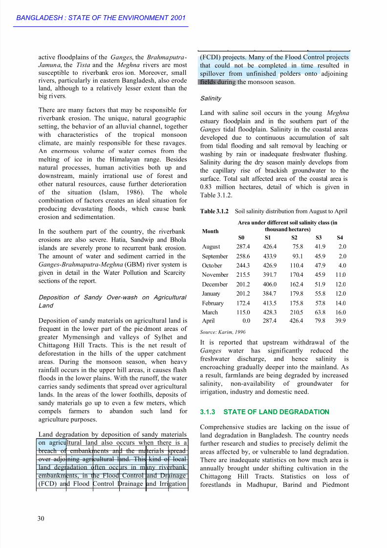
Salinity
Land with saline soil occurs in the young Meghna
estuary floodplain and in the southern part of the
Ganges tidal floodplain. Salinity in the coastal areas
developed due to continuous accumulation of salt
from tidal flooding and salt removal by leaching or
washing by rain or inadequate freshwater flushing.
Salinity during the dry season mainly develops from
the capillary rise of brackish groundwater to the
surface. Total salt affected area of the coastal area is
0.83 million hectares, detail of which is given in
Table 3.1.2.
Source: Karim, 1990
Table 3.1.2 Soil salinity distribution from August to April
Area under different soil salinity class (in
thousand hectares)
S0 S1 S2 S3 S4
August 287.4 426.4 75.8 41.9 2.0
September 258.6 433.9 93.1 45.9 2.0
October 244.3 426.9 110.4 47.9 4.0
November 215.5 391.7 170.4 45.9 11.0
December 201.2 406.0 162.4 51.9 12.0
January 201.2 384.7 179.8 55.8 12.0
February 172.4 413.5 175.8 57.8 14.0
March 115.0 428.3 210.5 63.8 16.0
April 0.0 287.4 426.4 79.8 39.9
Month
30
BANGLADESH : STATE OF THE ENVIRONMENT 2001
8/9/2019 Bangladesh Land
http://slidepdf.com/reader/full/bangladesh-land 7/16
plains for agriculture, and other uses are also
insufficient. There are few studies on the
wastelands created by abandoned brick fields, and
associated abandoned roads, but a good amount of
land once regarded as good agricultural land has
now turned unproductive. Statistics on irrigated
area and uses of different pesticides are available,
but studies on the extent of land degradation are
lacking. The information is insufficient to make a
comprehensive nationwide assessment on land
degradation. However, a number of case studies are
available, which do give an idea of the condition of
land and the state of land degradation. A few of
these examples are described below.
A few case studies have indicated that Jhum
cultivation has been intensified, and has shown an
increasing trend over the past few decades. Figure
3.1.2 shows the changing status of Jhum cultivation in
three forest ranges. An evaluation of the Sanghu-
Matamuhuri reserve forest indicated that shifting
cultivation, which was practically non-existent in
1961, accounted for 17,135 ha in 1984, which is about
23 per cent of the total area. In Kasalong, 2,096 ha
Topsoil erosion per unit area depends on the type ofland cover and land use practices. It was found thattopsoil erosion rate is 2.7 to 7.2 tons per ha perannum in the mixed forest-covered land. On theother hand, per hectare erosion goes up to 120 tonsin the deforested hill slopes (Shahid, 1994). A studyin Khagrachari, Rangamati and Bandarban area ontopsoil erosion revealed that topsoil erosion rangesfrom 100 to 120 tons per ha annually (Farid et. al., 1992).
The amount of organic matter in the
soil is one of the best indicators
representing soil quality. The
concentration of soil organic materials
in the country has been deterioratingover the last few decades. Now over
50 per cent of the agricultural land is
below the critical level. The highes t
deterioration of organic materials has
been found in the Barind Tract,
Madhupur Tract, Himalayan Foothill
areas, the floodplains of Tista,
Karatoya and Bangali, and in the
northeast hilly region. Moderate
deterioration of organic materials has
been observed in medium highlands of the rivers
Tista, the Jamuna and in the Ganges floodplain
(Karim et. al., 1994). Figure 3.1.3 shows changes of
organic materials from 1969-70 to 1989-90.
The Soil Resources Development Institute (SRDI) has
analyzed soil samples, and found that nitrogen
deficiency is common all over the country. The Sylhet
haor areas, Surma-Kushiyara floodplain, northeast
hilly area and Madhupur Tract have a noticeably
intense deficiency of Phosphorus. Deficiency of other
chemical substances has also been noticed in other
parts of the country.
were identified as Jhum areas in 1963, whereas in
1983 the area increased sharply to 35,079 ha. InRainkheong, in 1963 Jhum area was only 14 ha, which
increased to 30,838 ha in 1983 (Rahman, 1991).
Landsat imagery indicates a definite change invegetative cover and soil moisture in the Barind Tract, particularly the Western Barind. It resembles an aridzone during the months of March-April, although oncemoderately sized forest, bushes and shrubs werevisible (Hunt, 1984).
Erosion of topsoil in the hill districts has increased,and 17 per cent of the soil resources have
deteriorated between 1964 and 1985 (IUCN, 1991).
A vi ew of deforestation
LAND DEGRADATION
31
Source: Rahman, 1991
Figure 3.1.2 Changes of Jhum Cultivated Area in Three Forest Ranges
0
10000
20000
30000
40000
A r e a i n H a
.
Sanghu-
Matamuhuri
Kasalong Rainkheong
19831963

8/9/2019 Bangladesh Land
http://slidepdf.com/reader/full/bangladesh-land 8/16
As shown in Table 3.1.3, the level of organic matter
in the soil of Bangladesh is very low. About 45
per cent of the net cultivable area (NCA) of the
country has less than 1 per cent organic matter
content.
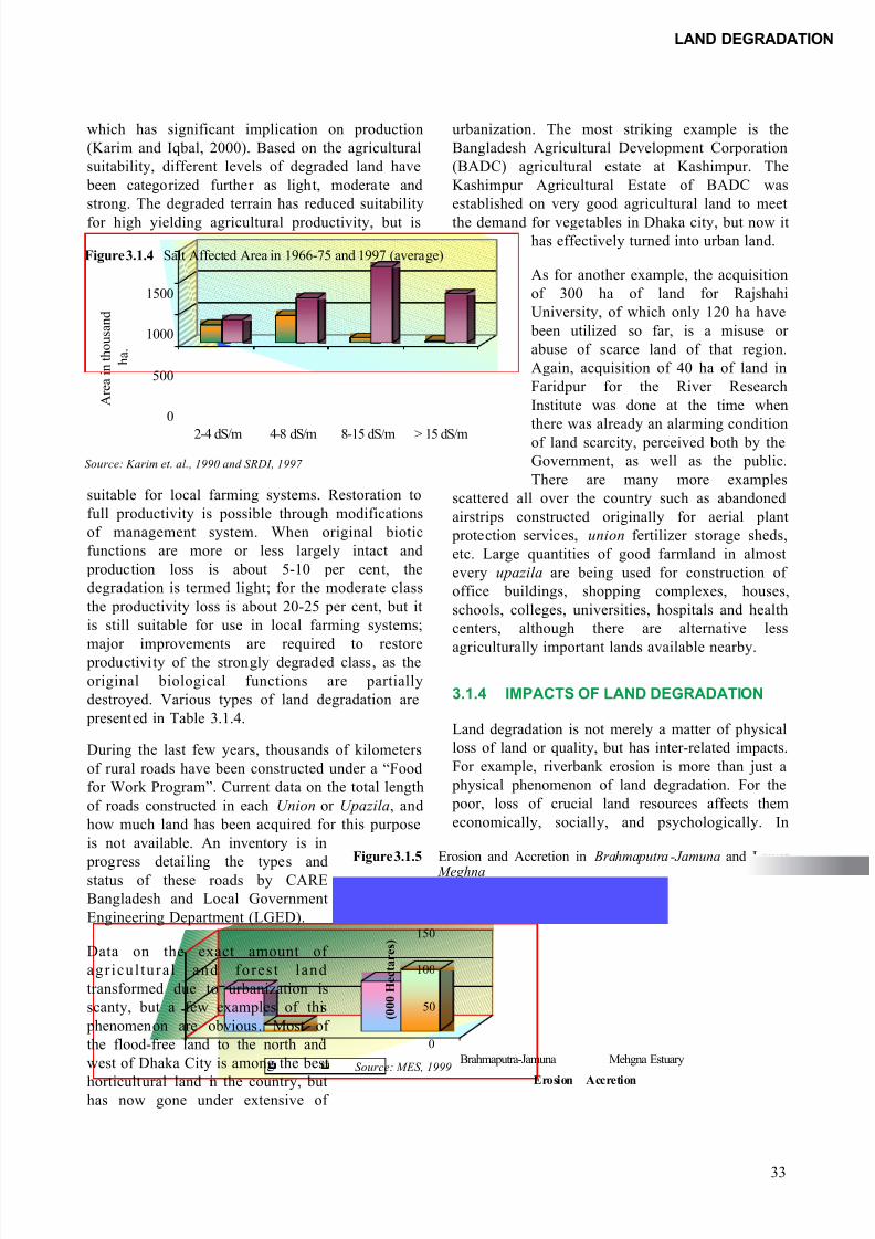
Accurate assessment of the salt affected area in thecoastal region is very difficult, as the level ofsalinity varies according to season and year.However, it is clear from different sources that thesalinity level of both surface water and soil hasincreased over the last decade. Saline affectedareas in the coastal district have increased to about
3.05 million in 1995 from 0.83 million ha in 1966-75 (Karim et. al., 1990 and SRDI, 1997). Noteworthy changes occurred in the categorieswhich lies above 8 dS/m. During the period of1966-75, a very small amount ofarea was under the category ofmore than 8 dS/m, which becameintense in 1995. Changes of salineaffected areas are shown in Figure3.1.4 in detail.
Studies on riverbank erosion haveshown that the overall erosion is
higher than sedimentation along theriverbanks in the Brahmaputra- Jamuna river system, and that thereis net accretion in the Meghna estuary starting from Chandpur.
The “Riverbank Erosion Impact
Study”, conducted jointly by
Jahangirnagar University and
University of Manitoba during 1984-
87 at three places, namely, Chilmari
(Rangpur), Kazipur (Serajgonj) and
Bhola, found that about 15,750 ha of
land eroded over the period of 1961 to 1981,
while only about 4,600 ha land have been
formed through accretion (Elahi, 1985).
Environment and GIS Support Project for
Water Sector Planning and Delft Hydraulicsconducted a study on behalf of Water
Resource Planning Organisation (WARPO)
on “Morphological Dynamics of the
Brahmaputra-Jamuna River” from 1973 to
1996, using remote sensing images. Their
study showed a total of 73,552 ha of land
eroded during the period of 1973 to 1996,
while only 10,628 ha of land have been
formed by accretion.
Analysis of remote sensing data for the period of
1993 to 1998 measured the net accretion in the Meghna estuary, starting from Chandpur towards
the Bay of Bengal (MES, 1999). Up to 1984,
erosion was higher than the accretion, but major
accretion occurred during the period 1984-1990 and
1993-1996. The accretion and erosion over the
years amounts to 107,863 and 87,967 ha,
respectively. Thus the net accretion in the Meghna
is about 19,896 ha. Figure 3.1.5 presents erosion
and accretion in the Brahmaputra-Jamuna and
Meghna river systems.
Based on currently available information and data,
it appears that all agricultural lands have degraded
to different extents. From this about 8 million ha
show fertility decline and def iciency of nutrients,
Source: BARC, 1999
Class of
organic
matter
Main Locations Total Area
(Mha)
% of
NCA
Very Low
(<1.0 %)
Dinajpur, Sherpur, Jamalpur, Tangail,
Nawa bgan j, Ra hsha hi , Pa bn a,
Kushtia, Bogra, Naogaon, Rangpur,
Khagrachari, Bandarban and
Chittagong
4.05 44.5
Low
(1.0-1.7 %)
Adjoining area of Tista, Dharlus,
Chandpur, Lakshimipur, Noakhali,
Bhola, Barisal, Patuakhali, Narsingdi
and Dhaka
1.56 17.1
Medium
(1.7-3.5 %)
Sirajganj, Mymensingh, Kishoreganj,
She rpu r , Jama lpu r , Sy lhe t ,
Moulvibazar, Feni and Cox’s Bazar
1.94 21.3
High
(>3.5 %)
Panchaghar, Natore, Naogaon,
Khulna, Satkhira, Madaripur,
Gopalganj, Munshiganj, Habiganj,
Sunamganj and Netrokina
1.56 17.1
Table 3.1.3 Organic Matter Status of Bangladesh Soils
32
BANGLADESH : STATE OF THE ENVIRONMENT 2001
0.00
0.50
1.00
1.50
2.00
2.50
P e r c e n t a g e o f O r g a n i c
M a t e r i a l
Madhupur Tract Barind Tract Northeast Hilly
Area
1969-70
1989-90
Figure 3.1.3 Changes in Organic Matters from 1969-70 to 1989-90
Source: Karim et. a l., 1994
8/9/2019 Bangladesh Land
http://slidepdf.com/reader/full/bangladesh-land 9/16
which has significant implication on production
(Karim and Iqbal, 2000). Based on the agricultural
suitability, different levels of degraded land have
been categorized further as light, moderate and
strong. The degraded terrain has reduced suitability
for high yielding agricultural productivity, but is
urbanization. The most striking example is the
Bangladesh Agricultural Development Corporation
(BADC) agricultural estate at Kashimpur. The
Kashimpur Agricultural Estate of BADC was
established on very good agricultural land to meet
the demand for vegetables in Dhaka city, but now it
has effectively turned into urban land.
As for another example, the acquisition
of 300 ha of land for Rajshahi
University, of which only 120 ha have
been utilized so far, is a misuse or
abuse of scarce land of that region.
Again, acquisition of 40 ha of land in
Faridpur for the River Research
Institute was done at the time when
there was already an alarming condition
of land scarcity, perceived both by the
Government, as well as the public.
There are many more examples
scattered all over the country such as abandoned
airstrips constructed originally for aerial plant
protection services, union fertilizer storage sheds,
etc. Large quantities of good farmland in almost
every upazila are being used for construction of
office buildings, shopping complexes, houses,
schools, colleges, universities, hospitals and health
centers, although there are alternative less
agriculturally important lands available nearby.
3.1.4 IMPACTS OF LAND DEGRADATION
Land degradation is not merely a matter of physical
loss of land or quality, but has inter-related impacts.
For example, riverbank erosion is more than just a
physical phenomenon of land degradation. For the
poor, loss of crucial land resources affects them
economically, socially, and psychologically. In
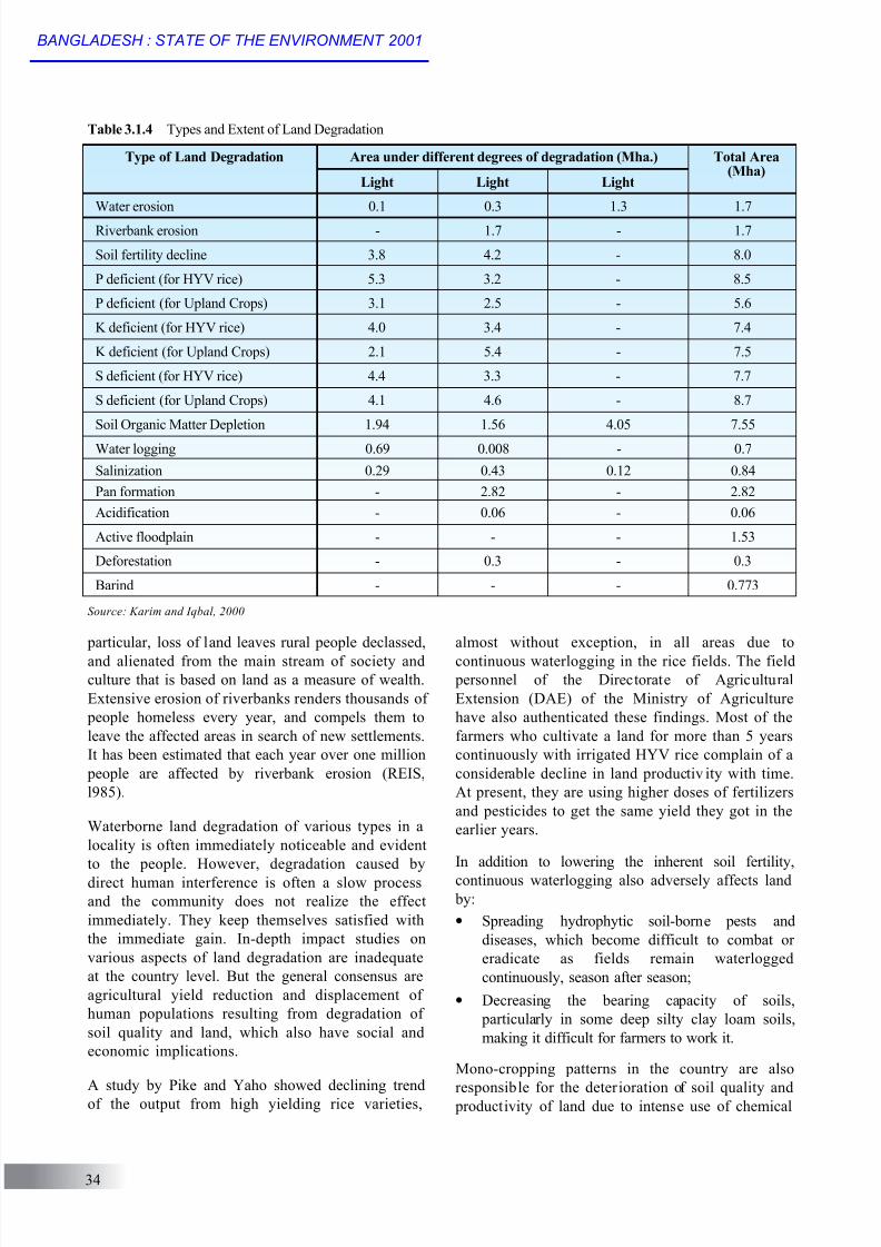
suitable for local farming systems. Restoration to
full productivity is possible through modifications
of management system. When original biotic
functions are more or less largely intact and
production loss is about 5-10 per cent, the
degradation is termed light; for the moderate class
the productivity loss is about 20-25 per cent, but it
is still suitable for use in local farming systems;
major improvements are required to restore productivity of the strongly degraded class, as the
original biological functions are partially
destroyed. Various types of land degradation are
presented in Table 3.1.4.
During the last few years, thousands of kilometers
of rural roads have been constructed under a “Food
for Work Program”. Current data on the total length
of roads constructed in each Union or Upazila, and
how much land has been acquired for this purpose
is not available. An inventory is in
progress detailing the types andstatus of these roads by CARE
Bangladesh and Local Government
Engineering Department (LGED).
Data on the exact amount of
agr icul tura l and forest land
transformed due to urbanization is
scanty, but a few examples of this
phenomenon are obvious. Most of
the flood-free land to the north and
west of Dhaka City is among the best
horticultural land in the country, buthas now gone under extensive of
Source: Karim et. al., 1990 and SRDI, 1997
Figure 3.1.4 Salt Affected Area in 1966-75 and 1997 (average)
0
500
1000
1500
A r e a i n t h o u s a n d
h a .
2-4 dS/m 4-8 dS/m 8-15 dS/m > 15 dS/m
Source: MES, 1999
Figure 3.1.5 Erosion and Accretion in Brahmaputra -Jamuna and Lower
Meghna
0
50
100
150
( 0 0 0 H e c t a r e s )
Brahmaputra-Jamuna Mehgna Estuary
Erosion Accretion
LAND DEGRADATION
33
8/9/2019 Bangladesh Land
http://slidepdf.com/reader/full/bangladesh-land 10/16
almost without exception, in all areas due to
continuous waterlogging in the rice fields. The field
personnel of the Directorate of Agricultural
Extension (DAE) of the Ministry of Agriculture
have also authenticated these findings. Most of the
farmers who cultivate a land for more than 5 years
continuously with irrigated HYV rice complain of a
considerable decline in land productiv ity with time.
At present, they are using higher doses of fertilizers
and pesticides to get the same yield they got in the
earlier years.
In addition to lowering the inherent soil fertility,
continuous waterlogging also adversely affects land
by:
• Spreading hydrophytic soil-borne pests and
diseases, which become difficult to combat or
eradicate as fields remain waterlogged
continuously, season after season;
• Decreasing the bearing capacity of soils,
particularly in some deep silty clay loam soils,
making it difficult for farmers to work it.
Mono-cropping patterns in the country are also
responsible for the deterioration of soil quality and productivity of land due to intense use of chemical
particular, loss of land leaves rural people declassed,
and alienated from the main stream of society and
culture that is based on land as a measure of wealth.
Extensive erosion of riverbanks renders thousands of
people homeless every year, and compels them to
leave the affected areas in search of new settlements.
It has been estimated that each year over one million
people are affected by riverbank erosion (REIS,
l985).
Waterborne land degradation of various types in a
locality is often immediately noticeable and evident
to the people. However, degradation caused by
direct human interference is often a slow process
and the community does not realize the effect
immediately. They keep themselves satisfied with
the immediate gain. In-depth impact studies on
various aspects of land degradation are inadequate
at the country level. But the general consensus are
agricultural yield reduction and displacement of
human populations resulting from degradation of
soil quality and land, which also have social and
economic implications.
A study by Pike and Yaho showed declining trendof the output from high yielding rice varieties,
Table 3.1.4 Types and Extent of Land Degradation
Source: Karim and Iqbal, 2000
Area under different degrees of degradation (Mha.) Total Area(Mha)
Light Light Light
Water erosion 0.1 0.3 1.3 1.7
Riverbank erosion - 1.7 - 1.7
Soil fertility decline 3.8 4.2 - 8.0
P deficient (for HYV rice) 5.3 3.2 - 8.5
P deficient (for Upland Crops) 3.1 2.5 - 5.6
K deficient (for HYV rice) 4.0 3.4 - 7.4
K deficient (for Upland Crops) 2.1 5.4 - 7.5
S deficient (for HYV rice) 4.4 3.3 - 7.7
S deficient (for Upland Crops) 4.1 4.6 - 8.7
Soil Organic Matter Depletion 1.94 1.56 4.05 7.55
Water logging 0.69 0.008 - 0.7
Salinization 0.29 0.43 0.12 0.84
Pan formation - 2.82 - 2.82
Acidification - 0.06 - 0.06
Active floodplain - - - 1.53
Deforestation - 0.3 - 0.3
Barind - - - 0.773
Type of Land Degradation
34
BANGLADESH : STATE OF THE ENVIRONMENT 2001
8/9/2019 Bangladesh Land
http://slidepdf.com/reader/full/bangladesh-land 11/16
fertilizers and pesticides, and deteriorating soil
quality (Karim et. al., 1998). This is emerging as an
important issue regarding sustainability of the
cropping pattern and productivity. Already,
Bangladesh is experiencing a decline or stagnation
in the yield of many crops. According to
Bangladesh Rice Research Institute (BRRI), 30
cropping patterns observed in 1997 of which 28
cropping patterns were found to have paddy as a
component. The noteworthy feature of the findings
were that nine all-rice patterns occupied 60 per cent
of the total area covered by 30 cropping patterns
(Karim and Iqbal, 2000). The deleterious effects of
continuous wet-culture of rice were seen in the
declining yields, and reduced availability of soil
nutrients, particularly sulphur and zinc. There is
also a decrease in soil organic content, due todecreasing practice trend in legume, green manure
and jute-based cropping.
Salinity is a problem for cropping in the dry season.
But in pre-monsoon and monsoon months, salinity is
no longer a limiting factor. As a result, it appears to be
possible to cultivate Aman varieties of rice in those
areas between late May and September. However,
even in such cases, the expected yield reduces to a
certain degree depending on the soil salinity
concentration (Karim et. al., 1990).
Shifting and hill cultivation in Chittagong district
not only degrade land productivity, but also causes
excess runoff. This accelerates soil erosion and
causes flash floods. The additional effect, other
than loss of the sloping land, is that soil particles
from erosion move down the slope, and are
deposited on the riverbed, in the adjoining basins
and over flat alluvial land. The beds of rivers and
deep basins have been raised, which has affected
drainage condition, and infertile soil material is
spread over flat alluvial land burying fertile topsoil.
Kaptai reservoir is now severely threatened by slowrising of the bed due to deposition of sediments
coming in with the river water as a results of
shifting cultivation in the surrounding hills. The
siltation rate of the Kaptai reservoir is given in the
Water Pollution and Scarcity chapters in detail.
These kinds of land degradation phenomenon are
also common in the northern piedmont areas, and
foothills of Sylhet and Comilla.
The most adverse effect on the land caused by the
rural road network is drainage congestion. Most of
these roads have inadequate number of culverts, because the authority in charge of construction
often lacked the expertise on drainage needs and
also had limited technical capability to determine
the sites where culverts were needed. As a
consequence, apart from the creation of man-made
floods, during heavy rainfall the floodwater recedes
slowly, so that agricultural land remains
waterlogged for a longer time. This limits the
cultivation of early high priced Rabi crops such as
mustard, lentil, wheat, etc. Now farmers in the
meander floodplain areas often complain that in
their fields “ Joo”, i.e., the optimum moisture
required for sowing and germination, is present
much later than a few years ago. Due to this,
ploughing of the land for Rabi crops is delayed.
Farmers are now compelled to grow late Rabi crops
such as Kheshari.
There is no doubt that loss of land due to riverbank
erosion causes not only morphological changes in
the land, but also in the socio-economic condition
of the affected people. A study by the Centre for
Urban Studies (CUS) shows that riverbank erosion
lad to displace people losing stability in their lives
and social status (CUS, 1988). The reality is that
displaced people suffer terribly not only from loss
of their land and housing, but also from a lack of
psychological and social assimilation in the new
places they settle. They are usually regarded as
unwanted wherever they settle either in the cities orin new rural areas.
When riverbank erosion claims land and homesteads,
the affected people have no alternative, but to move in
search of new land and shelter. Many of them migrate
to cities and are absorbed in urban informal-sector
activities. The presence of hundreds of uprooted
families on the 86 Km stretch of the BWDB
embankment from Kazipur to Chouhali, via Serajgonj,
testifies the magnitude of the riverbank erosion
problem in the mid Jamuna floodplain. According to an
estimate, about 8,000 households have becomesquatters on the embankment (Zaman and Babla,
1985).
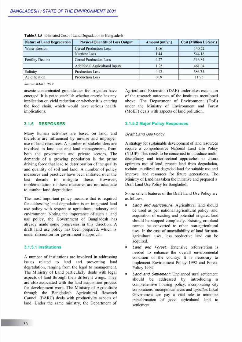
Besides its social and environmental aspects, theeconomic implications of land degradation aretremendous. An assessment has been made in terms of production loss of crops and additional agriculturalinput necessary to maintain soil nutrients. It was foundthat the total economic cost of land degradationexceeds to 2 billion US dollars per year, as presentedin detail in Table 3.1.5.
The presence of arsenic in the groundwater has beennoticed in Bangladesh, and concerns over the use of
LAND DEGRADATION
35
8/9/2019 Bangladesh Land
http://slidepdf.com/reader/full/bangladesh-land 12/16
arsenic contaminated groundwater for irrigation have
emerged. It is yet to establish whether arsenic has any
implication on yield reduction or whether it is entering
the food chain, which would have serious health
implications.
3.1.5 RESPONSES
Many human activities are based on land, and
therefore are influenced by unwise and improper
use of land resources. A number of stakeholders are
involved in land use and land management, from
both the government and private sectors. The
demands of a growing population is the prime
driving force that lead to deterioration of the quality
and quantity of soil and land. A number of policy
measures and practices have been initiated over the
last decade to mitigate these. However,implementation of these measures are not adequate
to combat land degradation.
The most important policy measure that is required
for addressing land degradation is an integrated land
use policy with respect to agriculture, industry and
environment. Noting the importance of such a land
use policy, the Government of Bangladesh has
already made some progresses in this direction. A
draft land use policy has been prepared, which is
under discussion for government’s approval.
3.1.5.1 Institutions
A number of institutions are involved in addressing
issues related to land and preventing land
degradation, ranging from the legal to management.
The Ministry of Land particularly deals with legal
aspects of land through their different wings. They
are also associated with the land acquisition process
for development work. The Ministry of Agriculture
through the Bangladesh Agricultural Research
Council (BARC) deals with productivity aspects ofland. Under the same ministry, the Department of
Agricultural Extension (DAE) undertakes extension
of the research outcomes of the institutes mentioned
above. The Department of Environment (DoE)
under the Ministry of Environment and Forest
(MoEF) deals with aspects of land pollution.
3.1.5.2 Major Policy Responses
Draft Land Use Policy
A strategy for sustainable development of land resources
require a comprehensive National Land Use Policy
(NLUP). This needs to be concerned to introduce multi-
disciplinary and inter-sectoral approaches to ensure
optimum use of land, protect land from degradation,
reclaim unutilized or degraded land for suitable use and
improve land resources for future generations. The
Ministry of Land has taken the initiative and prepared aDraft Land Use Policy for Bangladesh.
Some salient features of the Draft Land Use Policy are
as follows;
• Land and Agricultur e : Agricultural land should
be used as per national agricultural policy, and
acquisition of existing and potential irrigated land
should be stopped completely. Existing cropland
cannot be converted to other non-agricultural
uses. In the case of unavailability of land for non-
agricultural uses, less productive land can be
acquired.
• Land and Forest : Extensive reforestation is
needed to enhance the overall environmental
condition of the country. It is necessary to
implement Environment Policy 1992 and Forest
Policy 1994.
• Land and Settlement : Unplanned rural settlement
should be addressed by introducing a
comprehensive housing policy, incorporating city
corporations, metropolitan areas and upazilas. Local
Government can pay a vital role to minimize
transformation of good agricultural land tosettlement.
Table 3.1.5 Estimated Cost of Land Degradation in Bangladesh
Source: BARC, 1999
Nature of Land Degradation Physical Quantity of Loss Output Amount (mt/yr.) Cost (Million US $/yr.)
Water Erosion Cereal Production Loss 1.06 140.72
Nutrient Loss 1.44 544.18
Fertility Decline Cereal Production Loss 4.27 566.84
Additional Agricultural Inputs 1.22 461.04
Salinity Production Loss 4.42 586.75
Acidification Production Loss 0.09 11.95
36
BANGLADESH : STATE OF THE ENVIRONMENT 2001
8/9/2019 Bangladesh Land
http://slidepdf.com/reader/full/bangladesh-land 13/16
• Land and Industry : Industrial development is
necessary for development, and Bangladesh
obviously needs it. Land acquired by the
Bangladesh Small and Cottage Industries
Corporation (BSCIC) should be used properly,
and new industry should be discouraged within a
range of 10 km. As most of the industries were
found very close to major roads, it is also
proposed that 500 meters of land on both sides of
the main road should be dedicated to industrial
development.
• Land and Wetland : Highlighting the importance
of wetlands, advocate for implementing Fisheries
policy as a basis for wetland use.
• Land and Tea and Rubber Garden : Existing land
under tea and rubber gardens cannot be used for
other purposes, and valuable trees cannot be
harvested in an indiscriminate manner.
In addition, the Land Use Policy also highlights other
uses of land for different social and cultural purposes.
Certified land ownership is one of the important
aspects of the land use policy aiming at reduction of
ownership-related problems and crime. For
implementing the land use policy successfully, it
emphasizes mass awareness programs for the general
population and government administration.
Agri cultur e Policy 1999
Very recently the government has approved the
Agricultural Policy of 1999. The major thrust of the
policy is increased food production, and to address
food and nutritional insecurity issues through self-
sufficiency. It emphasizes environment-friendly,
sustainable agriculture, and strengthening of agro-
forestry programs of government and non-government
organizations. It also highlights the need for frontier
research, for example, on biotechnology and use of
GIS based information.
I ntegrated Pest M anagement Pol icy, 2000
Integrated Pest Management (IPM) activities started
in 1981, and have already passed through several
phases of research and extension. IPM has an
immense contribution in reducing the use of
pesticides for crop production. Results show that it
has the potential to increase crop production
directly and yet contaminate soil very little.
Considering these benefits of IPM, the Government
has initiated the National Integrated PestManagement Policy in 2000.
I ntegrated Plant N utr ient System (I PNS)
Integrated Plant Nutrient System (IPNS) is a new
concept to combat land degradation, particularly to
address degradation of soil and land quality, since it
uses a need-based nutrient application. In IPNS, theamount of nutrient application is specifically
determined through diagnostic testing and estimation of
the inherent nutrient status. Then there is a
recommended application of a mix of organic and
inorganic nutrients, including use of Biological
Nitrogen Fixation (BNF). This system ensures the
actual need for application of agricultural inputs and
avoid excess application. Proper extension and large-
scale adoption of this concept will reduce land
degradation in terms of soil quality, land productivity
loss and pollution by nutrients and nutrient availability
(Iqbal, 2000).
There are other national policies and measures that
have indirect positive impacts on combating land
degradation. The noteworthy policies are the
National Environment Policy, National
Environment Conservation Act and Rules, National
Forestry Policy, National Conservation Strategies,
and the Strategic Plan for National Agricultural
Research.
3.1.6 OPTIONS AND MEASURES NEED TOCOMBAT LAND DEGRADATION
A comprehensive study at the country level on land
degradation, covering all its aspects ranging from the
physical to economic, is absent. However, it is clear
that the quality of land has deteriorated, and its
impacts are visible. Over the last decade, crop yield
has declined due to deterioration of physical and
chemical properties of land and soil. It would be
useful to establish a baseline survey on which future
monitoring and assessment of further deterioration or
improvement could be based.
The country has a number of policies to deal with
land degradation, but with limited implementation.
The existing polices must be implemented, and a
number of new activities should be undertaken in
the immediate future to address land degradation.
Research and its extension to practice are the most
important steps that should start without delay.
Brief descriptions of future needs, along with
potential local stakeholders to undertake solving
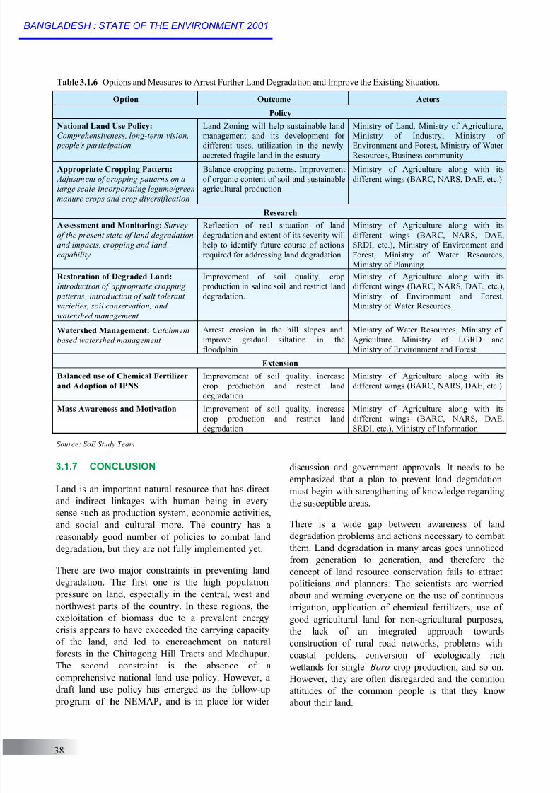
them, are presented in Table 3.1.6. A strategy is
also required to obtain support from internationalagencies.
LAND DEGRADATION
37
8/9/2019 Bangladesh Land
http://slidepdf.com/reader/full/bangladesh-land 14/16
3.1.7 CONCLUSION
Land is an important natural resource that has direct
and indirect linkages with human being in every
sense such as production system, economic activities,
and social and cultural more. The country has a
reasonably good number of policies to combat land
degradation, but they are not fully implemented yet.
There are two major constraints in preventing land
degradation. The first one is the high population
pressure on land, especially in the central, west and
northwest parts of the country. In these regions, the
exploitation of biomass due to a prevalent energy
crisis appears to have exceeded the carrying capacity
of the land, and led to encroachment on natural
forests in the Chittagong Hill Tracts and Madhupur.
The second constraint is the absence of a
comprehensive national land use policy. However, a
draft land use policy has emerged as the follow-up
program of the NEMAP, and is in place for wider
discussion and government approvals. It needs to be
emphasized that a plan to prevent land degradation
must begin with strengthening of knowledge regarding
the susceptible areas.
There is a wide gap between awareness of land
degradation problems and actions necessary to combat
them. Land degradation in many areas goes unnoticed
from generation to generation, and therefore the
concept of land resource conservation fails to attract
politicians and planners. The scientists are worried
about and warning everyone on the use of continuous
irrigation, application of chemical fertilizers, use of
good agricultural land for non-agricultural purposes,
the lack of an integrated approach towards
construction of rural road networks, problems with
coastal polders, conversion of ecologically rich
wetlands for single Boro crop production, and so on.
However, they are often disregarded and the common
attitudes of the common people is that they knowabout their land.
Table 3.1.6 Options and Measures to Arrest Further Land Degradation and Improve the Existing Situation.
Option Outcome Actors
Policy
National Land Use Policy:
Comprehensiveness, long-term vision, people's participation
Land Zoning will help sustainable land
management and its development fordifferent uses, utilization in the newly
accreted fragile land in the estuary
Ministry of Land, Ministry of Agriculture,
Ministry of Industry, Ministry ofEnvironment and Forest, Ministry of Water
Resources, Business community
Appropriate Cropping Pattern:
Adjustment of cropping patterns on a
large scale incorporating legume/green
manure crops and crop diversification
Balance cropping patterns. Improvement
of organic content of soil and sustainable
agricultural production
Ministry of Agriculture along with its
different wings (BARC, NARS, DAE, etc.)
Research
Assessment and Monitoring: Survey
of the present state of land degradation
and impacts, cropping and land
capability
Reflection of real situation of land
degradation and extent of its severity will
help to identify future course of actions
required for addressing land degradation
Ministry of Agriculture along with its
different wings (BARC, NARS, DAE,
SRDI, etc.), Ministry of Environment and
Forest, Ministry of Water Resources,
Ministry of Planning
Restoration of Degraded Land: Introduction of appropriate cropping
patterns, introduction of salt tolerant
varieties, soil conservation, and
watershed management
Improvement of soil quality, crop production in saline soil and restrict land
degradation.
Ministry of Agriculture along with itsdifferent wings (BARC, NARS, DAE, etc.),
Ministry of Environment and Forest,
Ministry of Water Resources
Watershed Management: Catchment
based watershed management
Arrest erosion in the hill slopes and
improve gradual siltation in the
floodplain
Ministry of Water Resources, Ministry of
Agriculture Ministry of LGRD and
Ministry of Environment and Forest
Balanced use of Chemical Fertilizer
and Adoption of IPNS
Improvement of soil quality, increase
crop production and restrict land
degradation
Ministry of Agriculture along with its
different wings (BARC, NARS, DAE, etc.)
Mass Awareness and Motivation Improvement of soil quality, increase
crop production and restrict landdegradation
Ministry of Agriculture along with its
different wings (BARC, NARS, DAE,SRDI, etc.), Ministry of Information
Extension
Source: SoE Study Team
38
BANGLADESH : STATE OF THE ENVIRONMENT 2001
8/9/2019 Bangladesh Land
http://slidepdf.com/reader/full/bangladesh-land 15/16
Politicians, decision makers and planners often do
not see the land as the scientists do. The scientists
see the land as a natural body, with its own delicate
balance, and that problems and consequences can
arise from its mistreatment. Farmers in general,
particularly small farmers, are suspicious of
innovations and are not easily convinced to use
scientific methods, which would benefit them from
resource conservation programs in the long run.
Present knowledge about the present status of the
land degradation process and its level of impacts on
national development and rural livelihood system is
inadequate, and definitely requires further
investigation and research. The potentiality of
preventing further degradation in the future is
uncertain, as the country suffers from a lack of
innovative technology and adoption of recent
technologies from outside the country, a low level
of education and social awareness, and limited
enforcement of laws and regulations. Therefore, in
order to combat land degradation and to attain
sustainable land management and development, it is
very urgent to build institutional capacity to
conduct field level research and apply the results
through extension programs along with enabling
policy makers to take necessary decision and to
undertake appropriate mitigation measures.
Reference
BARC (1997) Land Degradation Situation in Bangladesh.
Soil Division, Bangladesh Agricultural Research Council.
Dhaka, Bangladesh.
BBS (1994) Statistical Year Book of Bangladesh,
Bangladesh Bureau of Statistic, Ministry of Planning,
Dhaka, Bangladesh.
BBS (1998) Statistical Year Book of Bangladesh ,
Bangladesh Bureau of Statistic, Ministry of Planning,
Dhaka, Bangladesh.
CUS (1988) Composite Score map of Socio- economic
Development of Bangladesh by Upazila, Center for Urban
Studies, Dhaka University, Dhaka, Bangladesh.
Elahi, K.M. (1985) Riverbank Erosion and Floods in
Bangladesh: Need for Inventory and Planning, In REIS ,
Bulletin No. 2.
Farid, A.T., Iqbal, A. and Karim, Z. (1992) Soil Erosion in
the Chittagong Hill Tracts and Its Impact on Nutrient Status
of Soils, Bangladesh Journal of Soil Science, Vol. 23 (1&2),
Page 92-101.
Hunt, J.M. (1984) Area Development of Barind Tract ,
Dhaka, Bangladesh.
Iqbal, A. (2000) The Bangladesh National Report on the
Land, Water and Plant Nutrition in Bangladesh, Regional
Workshop on Land Resources Information System in Asia,
Manila, Philippines.
Islam, M.N. (1986) Alternative Adjustment to Natural
Hazards; Implication for Bangladesh, Presidential Addressat the 11 th Annual Bangladesh Science Conference,
Rajshahi, Bangladesh.
IUCN (1991) National Conservation Strategy of
Bangladesh (Draft), International Union for Conservation of
Nature and Natural Resources; Ministry of Environment and
Forest, GoB, Dhaka, Bangladesh. P. 83.
Karim, Z., Hussain, S.G. and Ahmed, M. (1990) Salinity
problems and crops intensification in the coastal region of
Bangladesh , Bangladesh Agricultural Research Council,
Dhaka, Bangladesh.
Karim, Z., Mia, M.M.U. and Razia, S. (1994) Fertilizer in
the National Economy and Sustainable Environmental
Development, Asia Pacific Journal Environment and
Development, 1 (2): 48-67.
Karim, Z., Hussain, S.G. and Rahman, M. (1998) Chemical
Fertilizer for Increase Crop Production Poses on Threat to
Soil Pollution in Bangladesh , Bangladesh Agricultural
Research Council, Dhaka, Bangladesh (unpublished).
Karim, Z and Iqbal, M.A. (ed.) (2000) Impact of Land
Degradation in Bangladesh: Changing Scenario in
Agricultural Land Use, Bangladesh Agricultural Research
Council, Dhaka, Bangladesh, (in press).
MES (1999) Technical Note 023. Meghna Estuary Study.Dhaka Bangladesh.
Pike, J.G. and Yano, T. (1986) Investigation of Lands with
Declining and Stagnating Productivity Report, Dhaka,
Bangladesh.
Rahman, M.R. (1991) Towards Sustainable Development
Land Resources in Bangladesh, Ministry of Environment &
Forest and National Conservation Strategy Secretariat,
Bangladesh Agricultural Resource Council, Dhaka,
Bangladesh.
REIS (1985) Riverbank Erosion Study, Jahangirnagar
University, Bangladesh and University of Manitoba, Canada.
Shahid, S.M. (1994) Data Collection and Analysis of Land
Degradation, Bangladesh Report, Bangkok, Rapa
Publication; 1994/3.
SRDI (1997) Task Force Report. Soil Resources
Development Institute, Dhaka, Bnaldesh.
UNDP (1989) Bangladesh Agriculture Sector Review.
Zaman, M.Q. and Babla, A.I. (1985) Rural Bastee; A Socio-
economic Background to the Squatter on the Jamuna Right
Bank Embankment , Dhaka, Bangladesh.
LAND DEGRADATION
39

8/9/2019 Bangladesh Land
http://slidepdf.com/reader/full/bangladesh-land 16/16
40
BANGLADESH : STATE OF THE ENVIRONMENT 2001