Embed Size (px)
DESCRIPTION
report
Citation preview
DEVELOPMENT PLAN OF BARDOLI
INDEX
1. INTRODUCTION1.1 BARDOLI PROFILE1.2 LOCATION AND LINKAGES1.3 HISTORICAL BACKGROUND OF TOWN1.4 EVOLUTION OF THE TOWN
2. POPULATION2.1 POPULATION SCENARIO
3. EXISTING LAND USE PATTERN4. HOUSING SCENARIO5. TRAFFIC AND TRANSPORTATION
5.1 ROAD CONNECTIVITY6. UTILITY AND SERVICES
6.1 WATER SUPPLY6.2 SEWERAGE6.3 SOLID WASTE6.4 ELECTRIC NETWORK6.5 TELECOMMUNICATION
7. PUBLIC AMENITIES7.1 EDUCATIONAL BUILDING7.2 HEALTH FACILITY7.3 SOCIO-CULTURAL FACILITIES
CHAPTER - 1
INTRODUCTION
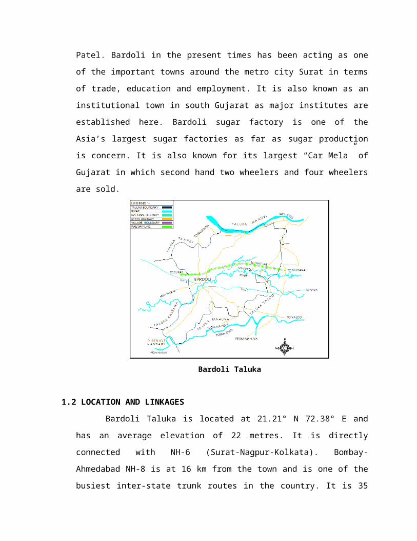
1.1 BARDOLI PROFILE
Bardoli Taluka is the heart of Surat district and is situated in centre of District.
It is the most developed Taluka amongst ten talukas of Surat district. It is well connected
with Surat-BhusawalTapti rail network. Three major rivers named Tapi, Mindhola and
Purna are passing through Bardoli taluka. It shares its boundary with Mandvitaluka on
North, Mahuvataluka on South, Valodtaluka on East, Palsanataluka on West,
Kamrejtaluka on North-West and Navsari district on South-West direction. NH-6 (Surat-
Nagpur-Kolkata) is passing through the heart of Bardoli Taluka.
Bardoli is a historical town as first freedom movement of India named “Bardoli
Satyagraha” was initiated from here in the great leadership of Sardar Vallabhbhai Patel.
Bardoli in the present times has been acting as one of the important towns around the
metro city Surat in terms of trade, education and employment. It is also known as an
institutional town in south Gujarat as major institutes are established here. Bardoli sugar
factory is one of the Asia’s largest sugar factories as far as sugar production is concern.
It is also known for its largest “Car Mela” of Gujarat in which second hand two wheelers
and four wheelers are sold.
Bardoli Taluka
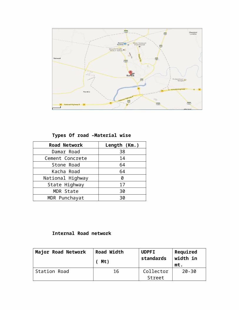
1.2 LOCATION AND LINKAGES
Bardoli Taluka is located at 21.21° N 72.38° E and has an average elevation of
22 metres. It is directly connected with NH-6 (Surat-Nagpur-Kolkata). Bombay-
Ahmedabad NH-8 is at 16 km from the town and is one of the busiest inter-state trunk
routes in the country. It is 35 Kms from Surat, 242 Kms from Mumbai and 278 Kms
from Ahmedabad. The city is well connected by Surat- Bhusawal rail network with the
other major cities and towns of the Gujarat state as well as states of Maharashtra and
Madhya Pradesh.
1.3 HISTORICAL BACKGROUND OF TOWN
It is believed that the history of Bardoli is associated with the ‘Kedareshwar
Temple’ near Bardoli which is approximately 1000 years old. It is situated on the bank
of the ‘Mindhola’ river which was known as ‘Mandakini’ river in the ancient world. The
‘Kedareshwar’ city was destroyed due to heavy floods in the river ‘Mandakini’, so
people started shifting to ‘Baladevi’ temple hills, and as time passes it gradually came to
be known as ‘Bardoli’. Bardoli town came into light after the draught of the year 1856
which was very terrible. To fight against that calamite and to provide help to the
surrounding region of Surat city; the Britisher’s started a railway from Surat to
Bhusawal. Railway Authority established Bardoli as there important station. Since then
Bardoli has been progressing constantly.
In year 1928, when the movement against the British Government taxes was
started, Sardar Vallabhbhai Patel was selected as a leader and the first freedom
movement was started from Bardoli which was called as ‘Bardoli Satyagraha’.
1.4 EVOLUTION OF THE TOWN
After the freedom of India, Bardoli Nagar was administrated by the District
Local Board. After several years it is declared as Bardoli gram Panchayat. Because of
continuous progress and expansion in population of city, from 1968 it became Bardoli
Nagar Panchayat and from 1986 it was declared as Bardoli Municipality which is
operational till today.
CHAPTER - 2
POPULATION
2.1 POPULATION SCENARIO
The total population of Bardoli Town according to 2001 census is 51946 people. The
total population of Bardoli Town according to 2011 census is 60815 persons and area is
7.36 sqkm.
Table No. 1.1: Population Scenario
Year Population % Growth Rate
1981 28131 -
1991 38377 36.42
2001 51946 35.35
2011 60815 17.07
Table No. 1.2: Ward wise Population
Word No.Total population
Persons Males Females Others1 6027 3043 2984 02 5576 2758 2818 03 6123 3250 2873 04 4607 2369 2238 05 4209 2237 1972 06 5250 2648 2602 07 6676 3504 3172 08 5040 2571 2469 09 4425 2251 2167 7
10 3092 1592 1498 211 5969 3037 2932 012 3821 1927 1894 0
Total 60815 14882 14132 9
POPULATION PROJECTION
Table No. 1.3 Population Projection
Year Population
Projection
% Growth Rate
2016 72726 19.58
2021 78253 7.60
2031 92652 18.40

CHAPTER - 3
EXISTING LAND USE PATTERN
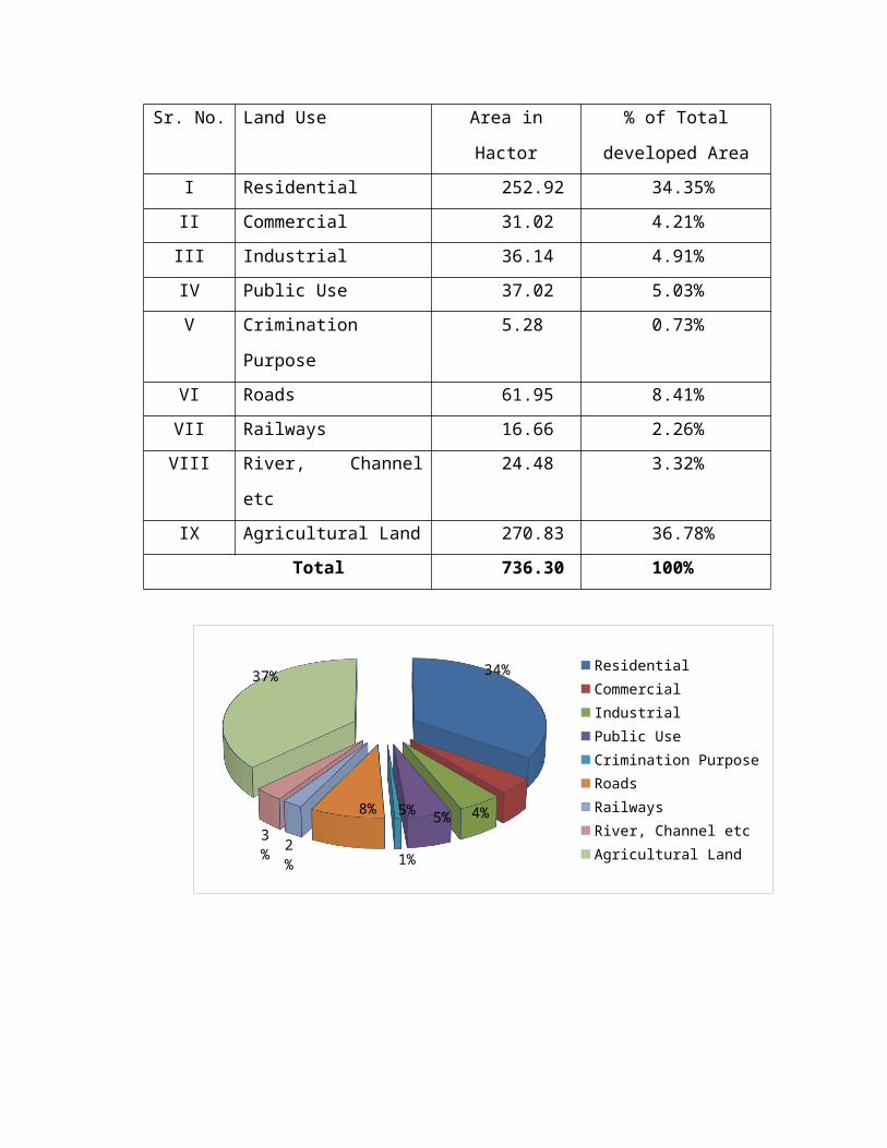
Table No. 1.4: Existing Land Use Pattern in Bardoli Town
Sr. No. Land Use Area in Hactor % of Total developed
Area
I Residential 252.92 34.35%
II Commercial 31.02 4.21%
III Industrial 36.14 4.91%
IV Public Use 37.02 5.03%
V Crimination Purpose 5.28 0.73%
VI Roads 61.95 8.41%
VII Railways 16.66 2.26%
VIII River, Channel etc 24.48 3.32%
IX Agricultural Land 270.83 36.78%
Total 736.30 100%
34%
4%5%5%
1%
8%
2%
3%
37%Residential
Commercial
Industrial
Public Use
Crimination Purpose
Roads
Railways
River, Channel etc
Agricultural Land
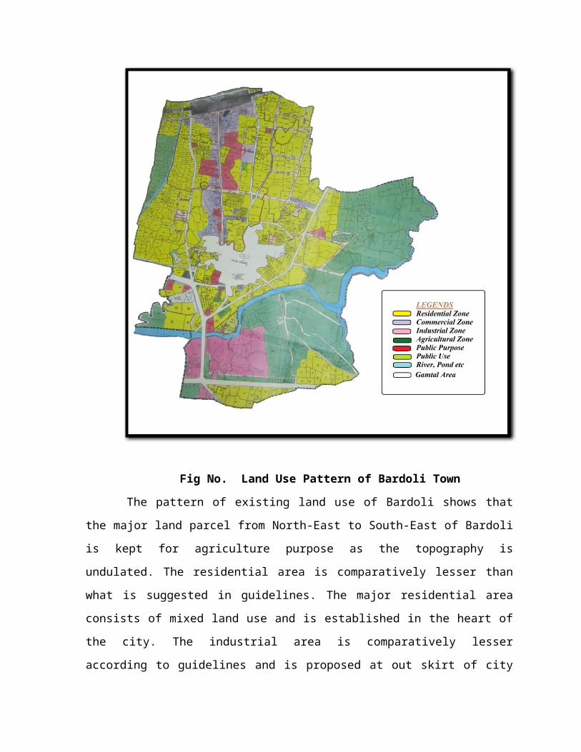
Fig No. Land Use Pattern of Bardoli Town
The pattern of existing land use of Bardoli shows that the major land parcel from
North-East to South-East of Bardoli is kept for agriculture purpose as the topography is
undulated. The residential area is comparatively lesser than what is suggested in guidelines.
The major residential area consists of mixed land use and is established in the heart of the
city. The industrial area is comparatively lesser according to guidelines and is proposed at
out skirt of city on southern side. The commercial area and recreational areas in the city are
not evenly distributed and those which are available are not properly developed.
CHAPTER - 4
HOUSING SCENARIO
As Bardoli town is growing it is found with all types of Building forms such as Gala type ,
Row houses, Bungalows, Low-rises & High-rise Residential apartments.
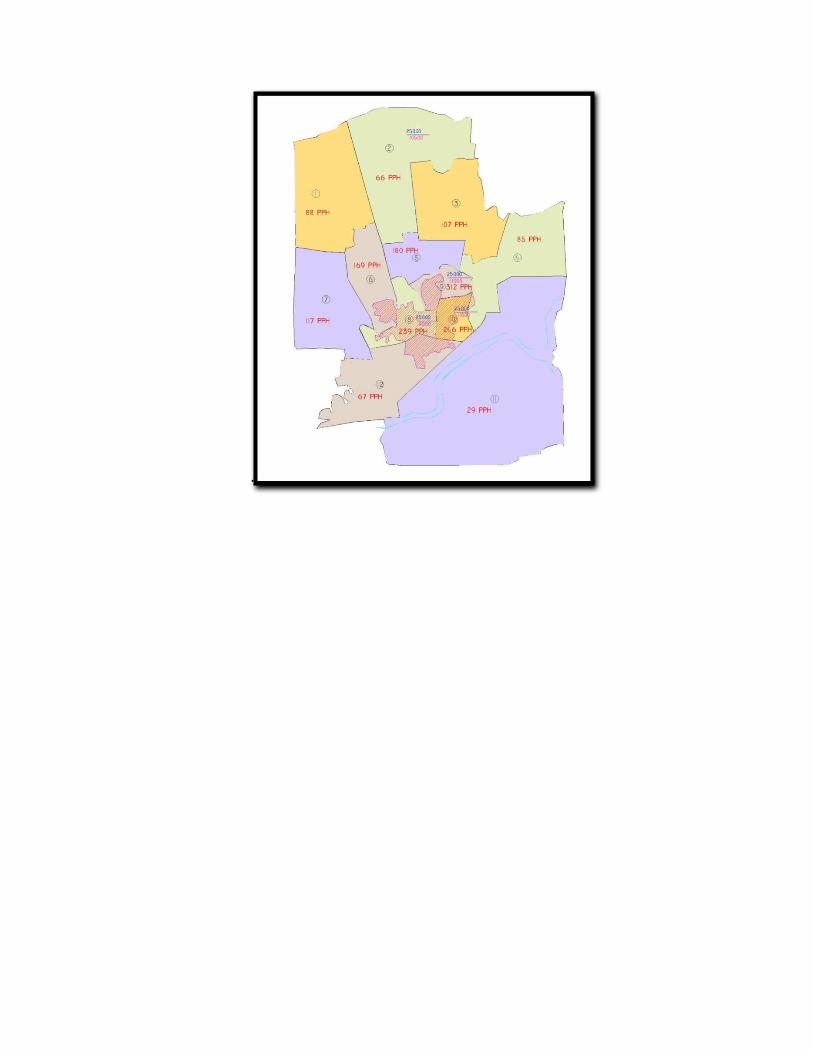
Table No. 1.5 Ward Wise Population Detail
Word No.
Total population
PersonsArea in
HECTORS Density(PPH)1 6027 68.32 88.217212 5576 84.44 66.035053 6123 56.7 107.98944 4607 53.62 85.919435 4209 23.36 180.17986 5250 30.92 169.7937 6676 56.88 117.36998 5040 21.08 239.08929 4425 14.18 312.059210 3092 12.53 246.767811 5969 200.72 29.7379412 3821 56.42 67.72421
Total 60815 679.17
The study indicates that the ward no’s 8, 9 & 10 are heavily dense as they fall in Gamtal
areas. The adjacent wards 5 & 6 are also dense. The wards 11 &2 are with low density as
they are developing.
To decongest the city core by providing attractive residential schemes with all necessary
amenities.
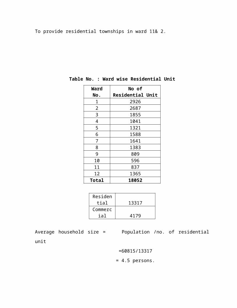
To provide residential townships in ward 11& 2.

Table No. : Ward wise Residential Unit
Ward No. No of Residential Unit
1 29262 26873 18554 10415 13216 15887 16418 13839 80910 59611 83712 1365
Total 18052
Residential 13317Commercia
l 4179
Average household size = Population /no. of residential unit
=60815/13317
= 4.5 persons.
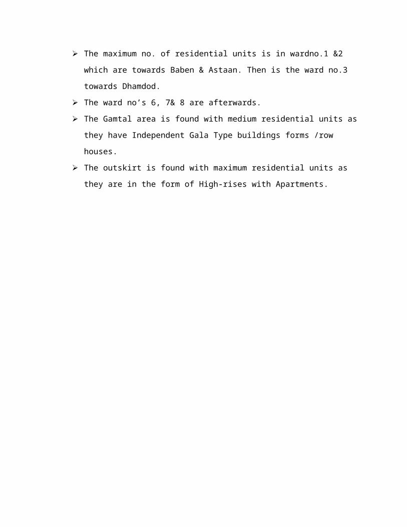
The maximum no. of residential units is in wardno.1 &2 which are towards Baben &
Astaan. Then is the ward no.3 towards Dhamdod.
The ward no’s 6, 7& 8 are afterwards.
The Gamtal area is found with medium residential units as they have Independent
Gala Type buildings forms /row houses.
The outskirt is found with maximum residential units as they are in the form of High-
rises with Apartments.
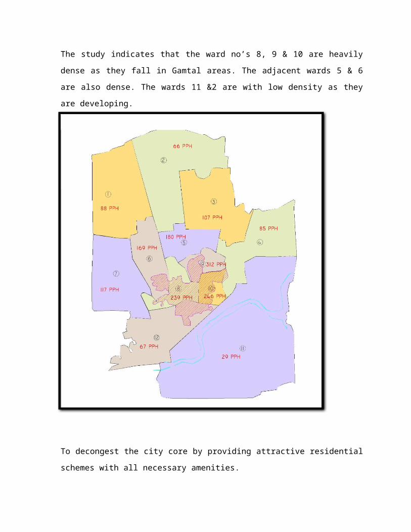
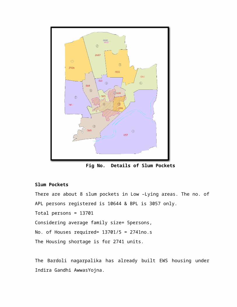
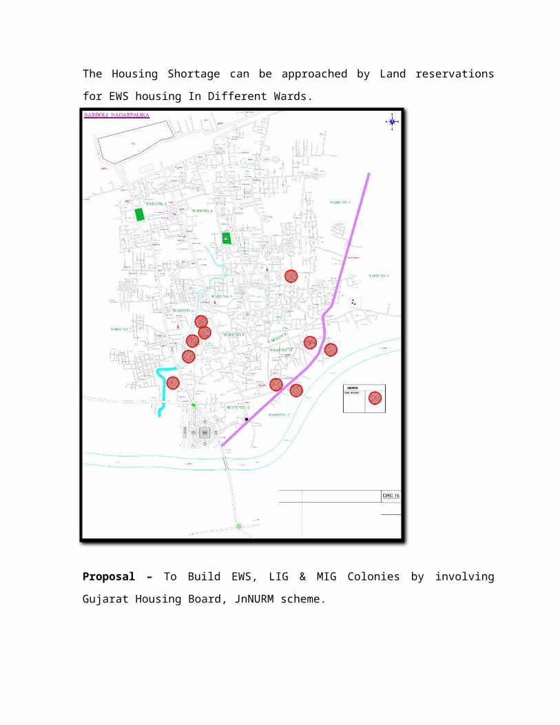
Fig No. Details of Slum Pockets
Slum Pockets
There are about 8 slum pockets in Low –Lying areas. The no. of APL persons registered is
10644 & BPL is 3057 only.
Total persons = 13701
Considering average family size= 5persons,
No. of Houses required= 13701/5 = 2741no.s
The Housing shortage is for 2741 units.
The Bardoli nagarpalika has already built EWS housing under Indira Gandhi AwwasYojna.
The Housing Shortage can be approached by Land reservations for EWS housing In
Different Wards.
Proposal – To Build EWS, LIG & MIG Colonies by involving Gujarat Housing Board,
JnNURM scheme.
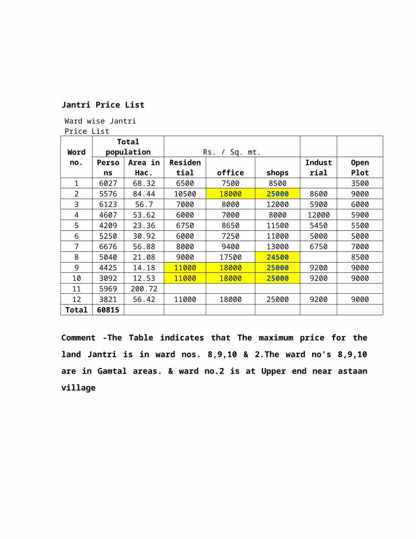
Jantri Price List
Ward wise Jantri Price List
Word no.
Total population Rs. / Sq. mt.Person
sArea in
Hac. Residential office shopsIndustria
l Open Plot1 6027 68.32 6500 7500 8500 35002 5576 84.44 10500 18000 25000 8600 90003 6123 56.7 7000 8000 12000 5900 60004 4607 53.62 6000 7000 8000 12000 59005 4209 23.36 6750 8650 11500 5450 55006 5250 30.92 6000 7250 11000 5000 50007 6676 56.88 8000 9400 13000 6750 70008 5040 21.08 9000 17500 24500 85009 4425 14.18 11000 18000 25000 9200 9000
10 3092 12.53 11000 18000 25000 9200 900011 5969 200.7212 3821 56.42 11000 18000 25000 9200 9000
Total 60815
Comment -The Table indicates that The maximum price for the land Jantri is in ward
nos. 8,9,10 & 2.The ward no’s 8,9,10 are in Gamtal areas. & ward no.2 is at Upper end
near astaan village
.
CHAPTER - 5
TRAFFIC AND TRANSPORTATION
5.1 ROAD CONNECTIVITY
It is very well connected to through networks of national and state highways.
There are many roads passing through Bardoli town. National highway 6 from Surat to
Kolkata and National Highway 8 connecting two major commercial hubs Ahmadabad
and Mumbai is passing through kadodara at 15 kms from Bardoli town.
Bardoli town and most of the villages are well connected by good quality of
roads to the major commercial and industrial places.
Heavy traffic movements and industrial activities are responsible for the degradation of
main roads as well as internal roads of Bardoli area.
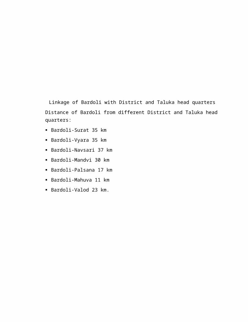
Linkage of Bardoli with District and Taluka head quarters
Distance of Bardoli from different District and Taluka head quarters:
Bardoli-Surat 35 km
Bardoli-Vyara 35 km
Bardoli-Navsari 37 km
Bardoli-Mandvi 30 km
Bardoli-Palsana 17 km
Bardoli-Mahuva 11 km
Bardoli-Valod 23 km.
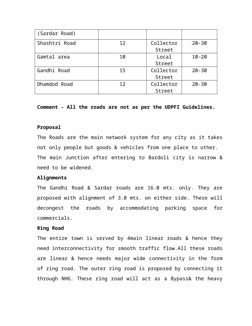
Types Of road –Material wise
Road Network Length (Km.)Damar Road 38
Cement Concrete 14Stone Road 64Kacha Road 64
National Highway 0State Highway 17
MDR State 30MDR Punchayat 30
Internal Road network
Major Road Network Road Width ( Mt) UDPFI standards
Required width in mt.
Station Road (Sardar Road) 16 Collector Street
20-30
Shashtri Road 12 Collector Street
20-30
Gamtal area 10 Local Street 10-20

Gandhi Road 15 Collector Street
20-30
Dhamdod Road 12 Collector Street
20-30
Comment - All the roads are not as per the UDPFI Guidelines.
Proposal
The Roads are the main network system for any city as it takes not only people but goods &
vehicles from one place to other.
The main Junction after entering to Bardoli city is narrow & need to be widened.
Alignments
The Gandhi Road & Sardar roads are 16.0 mts. only. They are proposed with alignment of
3.0 mts. on either side. These will decongest the roads by accommodating parking space for
commercials.
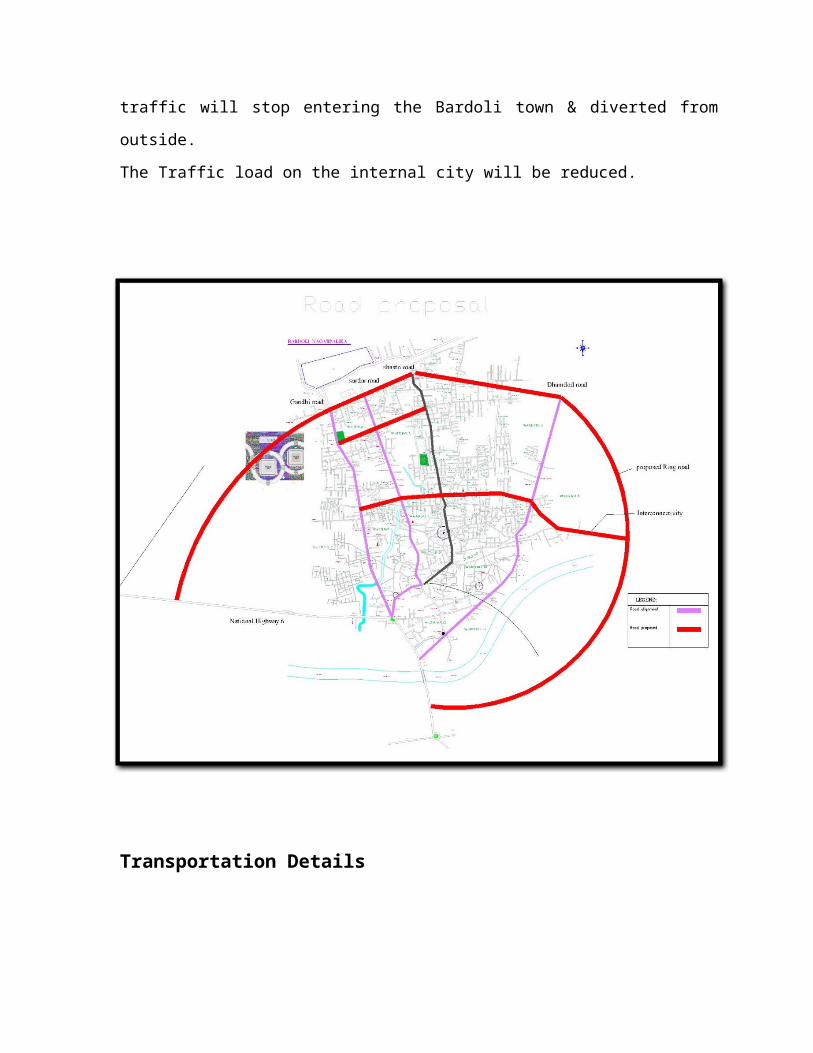
Ring Road
The entire town is served by 4main linear roads & hence they need interconnectivity for
smooth traffic flow.All these roads are linear & hence needs major wide connectivity in the
form of ring road. The outer ring road is proposed by connecting it through NH6. These ring
road will act as a Bypass& the heavy traffic will stop entering the Bardoli town & diverted
from outside.
The Traffic load on the internal city will be reduced.
Transportation Details
In Bardoli region total 10000 buses and trailers are registered till 2011. 5960 auto
rickshaws registered in RTO from 1996 to 2012. Total 1, 44,206 two wheelers are registered
in 2012. 672 are government vehicles run in Bardoli. 22,130 motor cars are registered in
Bardoli RTO.
Express buses are 88 which, going through Bardoli to other places. 66 local buses
also going through Bardoli.
CHAPTER - 6
UTILITY AND SERVICES
Bardoli Municipality is responsible for the delivery of variety of services like water
supply, sewerage, sanitation, solid waste management and Roads Transportation to the
people of Bardoli Town. They also provides services regarding medical facilities,
maternity and child welfare, control of food adulteration and some other function under
the public health regulation.
6.1 WATER SUPPLY
Bardoli Town has their own water supply system. A perineal river Mindhola passes
through the core of town but due to the deteriorated quality of water, it cannot be used as
a source for water supply. The main source of water is the ground water; being tapped
through bore wells or the water supply schemes supported by GWSSB (Gujarat Water
Supply and Sewerage Board).
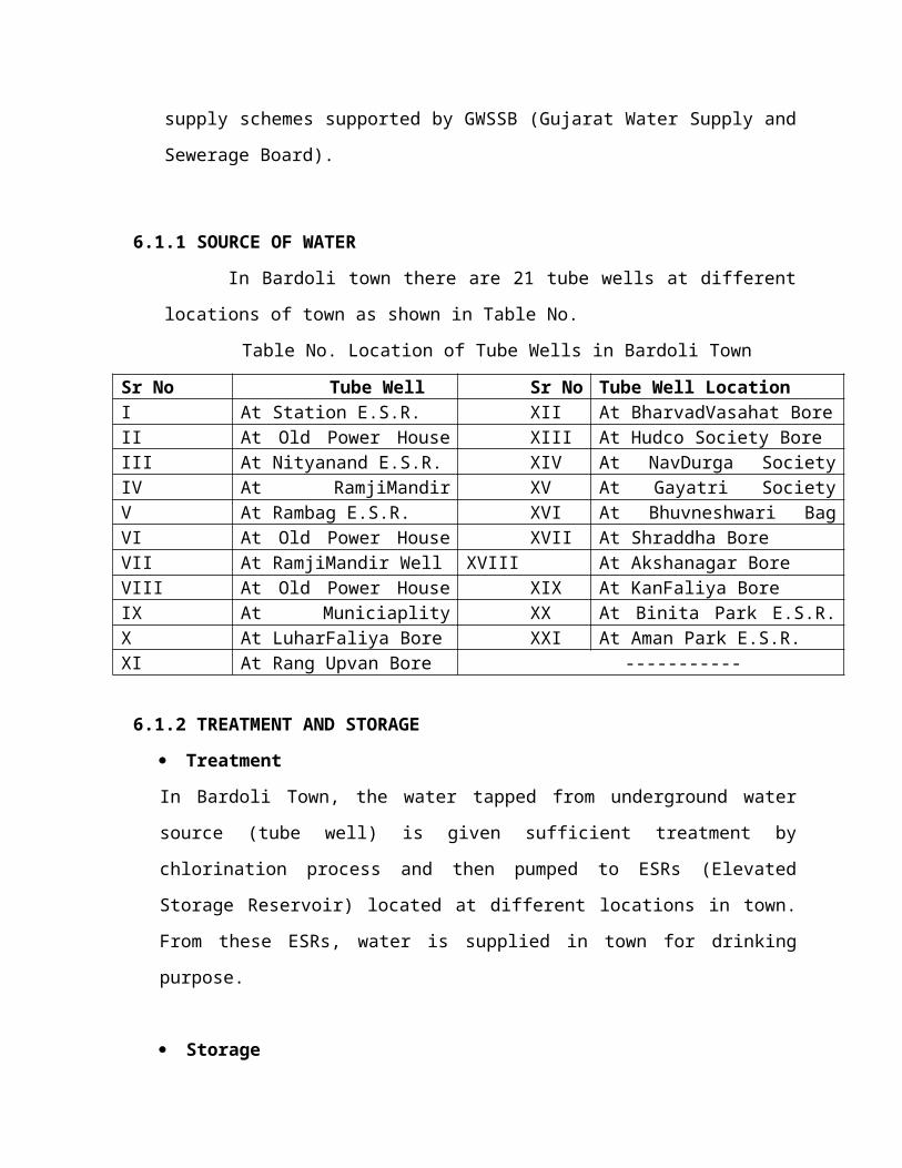
6.1.1 SOURCE OF WATER
In Bardoli town there are 21 tube wells at different locations of town as shown
in Table No.
Table No. Location of Tube Wells in Bardoli Town
Sr No Tube Well
Location
Sr No Tube Well Location
I At Station E.S.R. XII At BharvadVasahat Bore
II At Old Power House E.S.R. XIII At Hudco Society Bore
III At Nityanand E.S.R. XIV At NavDurga Society Bore
IV At RamjiMandir E.S.R. XV At Gayatri Society Bore
V At Rambag E.S.R. XVI At Bhuvneshwari Bag Bore
VI At Old Power House Sump XVII At Shraddha Bore
VII At RamjiMandir Well XVIII At Akshanagar Bore
VIII At Old Power House Bore XIX At KanFaliya Bore
IX At Municiaplity Bore XX At Binita Park E.S.R. (Khodiyar
E.S.R.)X At LuharFaliya Bore XXI At Aman Park E.S.R.
XI At Rang Upvan Bore -----------
6.1.2 TREATMENT AND STORAGE
Treatment
In Bardoli Town, the water tapped from underground water source (tube well) is given
sufficient treatment by chlorination process and then pumped to ESRs (Elevated Storage
Reservoir) located at different locations in town. From these ESRs, water is supplied in
town for drinking purpose.
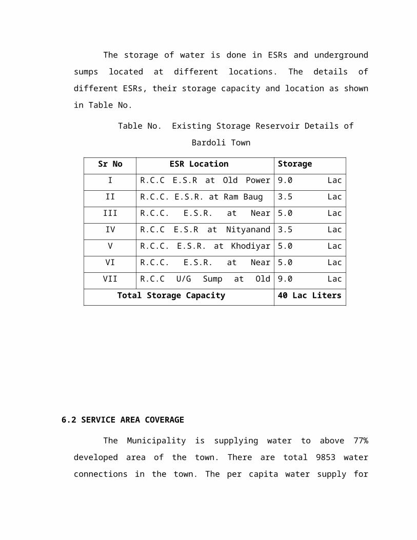
Storage
The storage of water is done in ESRs and underground sumps located at
different locations. The details of different ESRs, their storage capacity and location as
shown in Table No.
Table No. Existing Storage Reservoir Details of Bardoli Town
Sr No ESR Location Storage Capacity
I R.C.C E.S.R at Old Power House 9.0 Lac Liters
II R.C.C. E.S.R. at Ram Baug 3.5 Lac Liters
III R.C.C. E.S.R. at Near Railway Station 5.0 Lac Liters
IV R.C.C E.S.R at Nityanand Tank 3.5 Lac Liters
V R.C.C. E.S.R. at Khodiyar Nagar 5.0 Lac Liters
VI R.C.C. E.S.R. at Near RamjiMandir 5.0 Lac Liters
VII R.C.C U/G Sump at Old Power House 9.0 Lac Liters
Total Storage Capacity 40 Lac Liters
6.2 SERVICE AREA COVERAGE
The Municipality is supplying water to above 77% developed area of the town.
There are total 9853 water connections in the town. The per capita water supply for
Bardoli town is about 115 to 140 lpcd. The water is supplied 2 hours twice (morning and
evening) daily.
Water is supplied to the citizen through house service connection. In some areas in
addition to the connection hand pumps are provided by the Municipality.
6.2.2 SEWERAGE
Bardoli Town has its own sewerage network. The existing sewerage system covers the
Station Road, Shashtri Road, Ten Road, Gamtal area and some parts of Gandhi Road and
Dhamdod Road. The waste water of the town is collected in a lifting from four pumping
station located near Linear S.T Depo. The untreated sewage is finally discharged at
Nandida Village Disposal site which is 1.5 km away from Bardoli Town.
At present the area covered by sewerage network is only 45% of total inhabited
area. The total properties in the town are 15680 out of which 12000 properties have toilet
facility (11300 toilets + 700 common toilets) hence the toilet facility available in town is
76.53%.
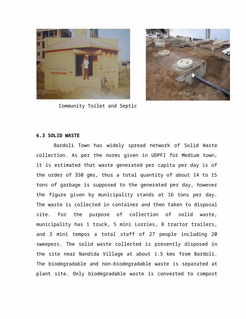
Community Toilet and Septic tank in Bardoli
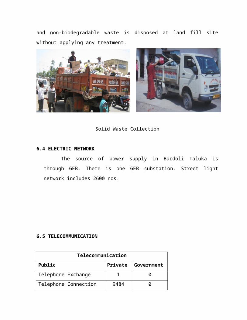
6.3 SOLID WASTE
Bardoli Town has widely spread network of Solid Waste collection. As per the
norms given in UDPFI for Medium town, it is estimated that waste generated per capita per
day is of the order of 350 gms, thus a total quantity of about 14 to 15 tons of garbage is
supposed to the generated per day, however the figure given by municipality stands at 16
tons per day. The waste is collected in container and then taken to disposal site. For the
purpose of collection of solid waste, municipality has 1 truck, 5 mini Lorries, 8 tractor
trailers, and 3 mini tempos a total staff of 27 people including 20 sweepers. The solid waste
collected is presently disposed in the site near Nandida Village at about 1.5 kms from
Bardoli. The biodegradable and non-biodegradable waste is separated at plant site. Only
biodegradable waste is converted to compost and non-biodegradable waste is disposed at
land fill site without applying any treatment.
Solid Waste Collection
6.4 ELECTRIC NETWORK
The source of power supply in Bardoli Taluka is through GEB. There is one
GEB substation. Street light network includes 2600 nos.
6.5 TELECOMMUNICATION
Telecommunication
Public Private Government
Telephone Exchange 1 0
Telephone Connection 9484 0
T.V set 8000 0
Radio 50 0
S.T.D,P.C.O 0 65
Cable Connection center 5000 0
Cyber cafe 0 10
Internet Connections 0 100
Courier services 0 10
CHAPTER – 7
PUBLIC AMENITIES
7.1 EDUCATIONAL BUILDING
Education Building No.UDPFI Guidelines
High secondary school 4 1
Secondary school 3 8
Primary School 3 12
Anganwadi 4 24
Aashram School 3 2
College 3 1
Total 20 48
Comment: As per UDPFI guidelines for Educational Building all the units provide in
No forms for Population. In the above table mention that for educational building 48
No’s required as per guideline but in existing condition provide only 20 Nos. So, there is
need to add this facility in proposal.
7.2 HEALTH FACILITY
Health facilitiesSr no. Health Building Government Private
UDPFI Guideline
1 Hospitals 1 20 1
2 Community Health center 1 0 1
3 Public Health center 1 0 1
4 Sub center 0 0 1
5 Maternity Hospital 1 0 1
6 Clinic 1 30 4
7 Operation theater 1 7 1
8 I.C.U 1 6 1
9 X Ray 0 3 1
10 Pathology Lab 1 11 1
11 Burn Ward 0 1 1
12 Blood Bank 0 1 1
13 Sonography center 0 3 1
14 Physiotherapy center 0 3 1
15 Medical Store 0 38 N.A.Total 8 123
Comment: As per UDPFI Guidelines for Bardoli Town Census Population 2011 are
60815. For this much population Health Facility is sufficient so no need to provide any
facility in proposal. For Health Facility in Bardoli provide Government and Private
Units.
7.3 SOCIO-CULTURAL FACILITIES
Sr. No.
Socio-Cultural Facilities No. UDPFINorms
1 Community Hall 6 12
2 Agriculture Cooperating Society
3 N.A.
3 Milk cooperating Society 2 N.A.
4 Service cooperating Society 2 N.A.
5 Police Station 1 1
6 Kerosene Port 2 N.A.
7 Gas agency 4 1
8 Post Office 2 N.A.
9 Cinema 1 1
10 Circuit House 1 1
11 Private Bank 4 N.A.
12 Nationalize Bank 9 N.A.
13 Library 0 4
14 Fire Station 1 1
Comment: As per UDPFI Guidelines for Bardoli Town Census Population 2011 are
60815. For this much population Socio-cultural Facilities are sufficient for Police
station, Gas agency, Cinema, Circuit house, Fire station so no need to provide any
facility in proposal. Library and community hall are need to proposed because as per
UDPFI Guide line it require more as per above table.
CHAPTER – 8
PROPOSALS FOR DEVELOPMENT PLAN
PROPOSALS FOR DEVELOPMENT PLAN
SHORT TERM PROPOSAL (2016) -AGRICULTURAL
It includes Bardoli with BABEN village.
Proposal for Agriculture institute in & Agri SEZ & Agri mall in ten.
Proposal for recreational areas garden & parks as pollution due to factory.
SHORT TERM -2016 POPULATION DENSITY AREA in ha.
BABEN 12650
BARDOLI 72725
85375 80 12.01
MEDIUM TERM PROPOSAL (2021)-
It Includes TEN village.
TENvillage has full potential development for Agricultural industry
Proposal for road development.
Proposal for Art & craft centre.
Proposal for primary & secondary school with Graduate College
MEDIUM TERM-2021 DENSITY AREATEN 7133BARDOLI 78254BABEN 13926
99313 80 17.91
LONG TERM PROPOSAL (2031)
It includes the village Umrakh & astaan.
Umrakh will also be included with Residential & Educational land use.
Long TERM-2031 POPULATION DENSITY AREATEN 8477BARDOLI 92653BABEN 17482ASTAAN 7307Umarakh
125919 80 24.11