Embed Size (px)
Citation preview

Barkly District
Land Condition
GuideGuide
Understanding the productivity of grazing lands

This guide was produced by the Northern Territory Government in association with the Northern Territory Cattlemen’s Association as part of the Caring for Our Country project “Grazing Land Management – Demonstration, Continuation and Evaluation”.
AuthorCaroline Pettit
AcknowledgementsThe author would like to thank the following for their contribution to the development of this publication:Whitney Dollemore, Jodie Ward, Robyn Cowley, Trudi Oxley, Dionne Walsh, Chris Materne, Charmayne Craven, Lee Crothers, Steve Eldridge and Jason De Araujo.
PhotographsThe author would like to thank the following for contributing photographs to this publicationCassie Duggan, Camilla Osborn, Arthur Cameron, NRETAS Weed Management Branch, Graeme Owen, Whitney Dollemore and Chris Materne.
Further information on land condition can be found through the Grazing Land Management (GLM) workshops. For information about the GLM courses available in the Northern Territory please contact the Department of Resources on 8973 9763.

1
Land Condition Guide
Contents
Introduction ............................................................................................................2
Using this guide .....................................................................................................7
Mitchell grass country ........................................................................................8Barkly land system
Northern heavy clays ........................................................................................10Creswell land system
Spinifex on northern red soils .......................................................................12Pollyarra land system
Southern red country........................................................................................14Wonorah land system
Species list ..........................................................................................................16
Map Barkly land systems ................................................................................17

2
This booklet is a pastoral land condition assessment tool that has been produced to assist land managers.
Land condition can be described as the ability of land to respond to rainfall and produce useful forage. Country in good condition is robust and can recover quickly from stresses such as grazing, fi re or a few dry years.
Land in poor condition is lacking in productive perennial pastures and is often affected by soil erosion due to a decline in ground cover and the stabilising effects of perennial grass tussocks and roots.
Often land is somewhere between good and poor condition where pastures are in some state of decline or soil condition is starting to deteriorate. It is important to understand what processes are causing the decline so that changes in management can be implemented before land condition declines further.
To assess a given area for land condition we look at FOUR major features of the landscape: pasture structure and composition, soil condition, presence of weeds and woodland structure. Table 1 outlines how these features change with varying land condition states and what criteria must be met to assign an area to a land condition group.
Land condition is divided into 4 categories A, B, C and D condition with A condition being the best andD condition the worst.
Table 1
Land Condition Soil Pasture Weed Woodland
A(All of these features)
No erosion and good surface condition
Good coverage of 3P grasses*, little bare ground (<30%) in most years
Few weeds and no signifi cant infestations
No signs of woodland thickening
B(At least one or more of these features)
Some signs of previous erosion and some current signs of erosion risk
Some decline in the presence of 3P grasses and/or bare ground (more than 30%, but less than 50% in most years)
Small infestations of weeds
Some thickening in the density of woody plants
C(One or more of these features)
Obvious signs of past erosion and/or current susceptibility to erosion
General decline in the presence of 3P species and/or bare ground (>50% in most years)
Obvious presence of weeds
General thickening in the density of woody plants
D(One or more of these features)
Severe erosion, scalding or compaction resulting in a hostile environment for plant growth
General lack of any perennial grasses or forbs
Large weed infestations covering signifi cant areas
Thickets of woody plants that cover signifi cant areas
*3P grasses = Palatable, Productive Perennial grasses
Land Condition Guide
Introduction
Good condition Poor condition

3
SoilGood soil condition is important for healthy plant growth. The uppermost layer of the soil is known as top soil or the A horizon. This layer is anywhere from a few cm to 20+ cm deep and is where seed germination occurs and plants concentrate their roots for stability and nutrient uptake. When top soil is eroded, plants struggle to establish which leads to less ground cover and subsequently higher rates of runoff, reduced infi ltration of rain water and further erosion.
The key to maintaining soil condition is good plant cover. Plant tussocks and leaf litter provide barriers which slow the velocity of water and wind and reduce resource loss from the system.
Types of soil erosionThese are some of the erosional processes that may occur in land with declining land condition.
Rills and GulliesChannels cut upslope by fl owing water, often initiated by water fl owing down a cattle pad, fence line or road.
TerracettesSmall abrupt walls 1-10cm high cut into the slope and aligned with the contour.
Sheeting or sheet erosionProgressive removal of thin layers of soil across extensive areas.
ScaldingThe loss of A horizon material to expose a hard-setting subsurface horizon.
HummockingConfi ned to soils with coarse textured surface layers such as sand and is the result of accumulation of wind borne material around obstructions.
PedestallingRemoval of soil from around obstructions (commonly plants) to leave them perched on a mound above the surrounding soil surface.
Rill erosion Sheet erosion Pedestalling erosion

4
PastureThe presence of palatable productive perennial grasses (3P’s) in most cases indicates good land condition. These species are the fi rst to disappear under heavy grazing and are often replaced by less productive grasses and forbs. Carrying capacity is therefore reduced because there is less palatable forage for stock.
Some land types such as those dominated by spinifex don’t typically meet the 3P grass criteria for good land condition. While spinifex is not as productive or palatable as other 3P grasses, it is perennial and can facilitate good land condition when other land condition components are maintained.
Areas of land in good condition have healthy soils that provide water and nutrients for plants to grow. In return, the plants help protect the soil and return nutrients through decomposing leaf litter. Carbon is also captured and stored effectively where good land condition occurs. When land condition declines, the cycle is broken and resources such as nutrients and water are lost from the system.
A modifi cation in grazing strategies can assist in improving pasture condition. Wet season spelling, rotational grazing and stocking rate adjustments can encourage the re-establishment of preferentially grazed pasture species and increase ground cover.
Strategic burning can also be used to manage pastures by removing rank growth and modifying grazing distribution. In the Barkly, a low-moderate intensity fi re after rain at the beginning of the wet season is recommended for black soil pastures to improve pasture quality and encourage more even grazing as cattle will be less selective when grazing new growth. At least 1500kg/ha is required to successfully burn under these conditions.
Annual-dominated pastures do not respond well to fi re. As annual species only live for one year, a fi re can completely remove ground cover until the next rains occur and seeds are germinated. If fi re occurs before the annual species have set seed then the seed bank is depleted and even good rain may not produce much forage.
Land in poor condition often has wide spaces between grass tussocks which allow resources to leave the local ecosystem. More bare ground also leads to greater rates of erosion by wind and water which accelerates the decline in land condition.
The solid lines represent the movement of resources such as nutrients, water or vegetative cover such as leaves. The dashed lines show how the grass tussocks encourage the retention of these resources so they remain available to the surrounding plants.

5
Weeds and woody thickeningA decline in land condition is not always a decline in vegetative growth. A weed infestation or woody thickening will also decrease land condition while maintaining some of the “good” condition characteristics such as ground cover. However weeds and woody thickening can have a large impact on land condition because they require more intensive and expensive management techniques to rectify.
Weeds, trees and shrubs in large numbers affect land condition by competing with pastures for nutrients, water and sunlight. Minor weed infestations or woody thickening can quickly spread to dominate the landscape, inhibiting pasture growth and making them less viable for cattle production.
Fire can be used to kill or suppress tree growth when fuel loads are upwards of 2000kg/ha and the species are sensitive to fi re. For fi re to be effective, trees need to be less than 200cm tall and ground cover must be greater than 40-50%. A fi re frequency of 5-10 years is recommended so that re-sprouting woody plants don’t become too tall before the next burn. Where woody thickening is already a problem, fuel loads upwards of 3500kg/ha may be required for successful woody control.
Not all land types respond well to fi re. Burning annual-dominated pastures lead to exposed soils and reduced seed banks. Spinifex is also sensitive to fi re in drier areas and a late dry season fi re may kill the plant.
Other options for woody thickening and weed control include chemical and/or mechanical treatments however prevention is the most successful and cost effective control method.
Weeds of signifi cance in the Barkly region include:
Parkinsonia on Barkly land system Rubberbush on Barkly land system
• Prickly acacia • Parkinsonia• Mesquite• Rubber bush• Noogoora burr
• Bellyache bush• Needle bush (Mimosa bush)• Mossman river grass• Khaki weed
6
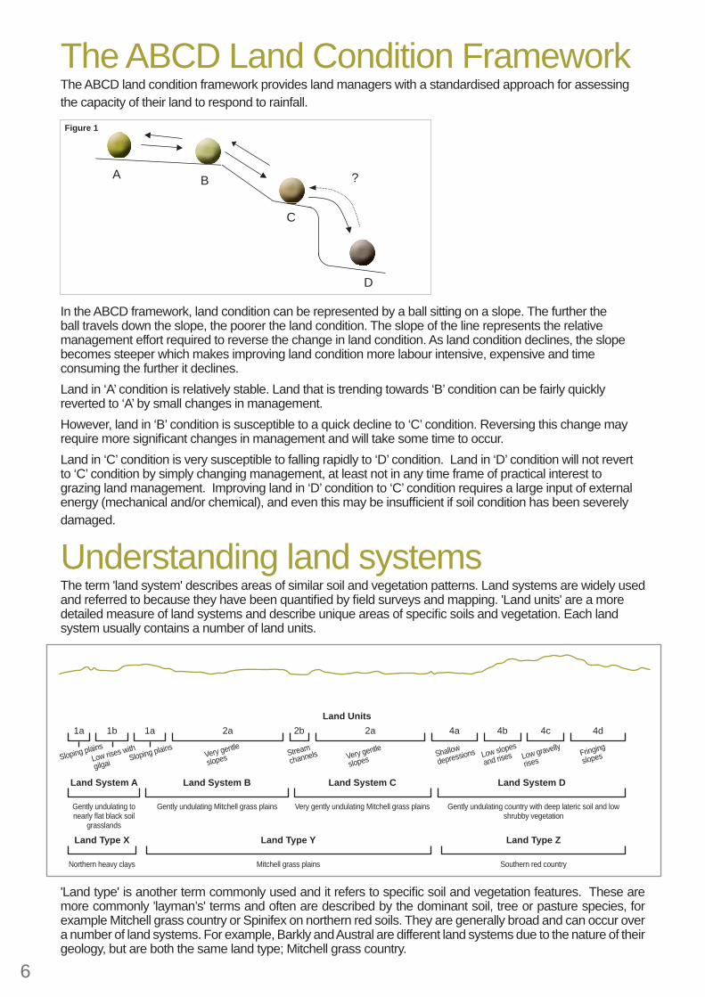
The ABCD Land Condition FrameworkThe ABCD land condition framework provides land managers with a standardised approach for assessing the capacity of their land to respond to rainfall.
In the ABCD framework, land condition can be represented by a ball sitting on a slope. The further the ball travels down the slope, the poorer the land condition. The slope of the line represents the relative management effort required to reverse the change in land condition. As land condition declines, the slope becomes steeper which makes improving land condition more labour intensive, expensive and time consuming the further it declines.Land in ‘A’ condition is relatively stable. Land that is trending towards ‘B’ condition can be fairly quickly reverted to ‘A’ by small changes in management.However, land in ‘B’ condition is susceptible to a quick decline to ‘C’ condition. Reversing this change may require more signifi cant changes in management and will take some time to occur.Land in ‘C’ condition is very susceptible to falling rapidly to ‘D’ condition. Land in ‘D’ condition will not revert to ‘C’ condition by simply changing management, at least not in any time frame of practical interest to grazing land management. Improving land in ‘D’ condition to ‘C’ condition requires a large input of external energy (mechanical and/or chemical), and even this may be insuffi cient if soil condition has been severely damaged.
?
D
C
BA
Figure 1
1a 1b 1a 2a 2b 2a 4a 4b 4c 4d
Gently undulating to nearly fl at black soil
grasslands
Northern heavy clays
Gently undulating Mitchell grass plains
Mitchell grass plains
Very gently undulating Mitchell grass plains Gently undulating country with deep lateric soil and low shrubby vegetation
Southern red country
Sloping plainsLow rises with
gilgai Sloping plainsVery gentle
slopes Very gentle
slopesShallow
depressions Low slopes
and rises Low gravelly
risesFringing
slopesStream
channels
Land Units
Land System C Land System DLand System BLand System A
Land Type YLand Type X Land Type Z
Understanding land systemsThe term 'land system' describes areas of similar soil and vegetation patterns. Land systems are widely usedand referred to because they have been quantifi ed by fi eld surveys and mapping. 'Land units' are a moredetailed measure of land systems and describe unique areas of specifi c soils and vegetation. Each landsystem usually contains a number of land units.
'Land type' is another term commonly used and it refers to specifi c soil and vegetation features. These are more commonly 'layman’s' terms and often are described by the dominant soil, tree or pasture species, for example Mitchell grass country or Spinifex on northern red soils. They are generally broad and can occur over a number of land systems. For example, Barkly and Austral are different land systems due to the nature of their geology, but are both the same land type; Mitchell grass country.

7
Carrying capacity assumptions and notesLong term carrying capacity is the average number of animals that a paddock can be expected to support over a planning horizon (5-10 years) without affecting land condition.
Pasture growth estimates have been calculated using models created from data collected from monitoring sites across the NT.
Carrying capacity fi gures assume all land is within 3-5km of water (depending on terrain).
Discounts for pasture growth for land condition changes have been calculated using GLM principles
Pasture growth may vary outside of the given ranges depending on the type of land condition decline you have. Where high yielding weeds and undesirable plants invade, pasture growth values may actually behigher but the overall productivity of useful forage or carrying capacity would be reduced.
Utilisation rates are based on research work conducted across northern Australia. As a general rule,recommended utilisation rates are 20% for robust black soils, 15% for productive red soils with perennialgrasses, 10% for poorer red soils with a mix of less palatable perennial and annual grasses and 5% forspinifex dominated land types.
Utilisation rate recommendations and carrying capacity fi gures have been excluded for land in D condition. While pastures in this condition can grow limited grass, it is not recommended that these areas be grazed until land condition can be improved.
Table 2Land Condition
Discount applied to pasture growth Land Condition
Discount applied to pasture growth
A 100% of A condition pasture growth C 45% of A condition pasture growthB 75% of A condition pasture growth D 20% of A condition pasture growth
Using this guideThis guide includes information on pasture growth and carrying capacity for a selection of land systems in the region. Above the land system name is a general land type description. This will help you identify which pages are most suitable to land systems not mentioned in the booklet.Use the land system photos in conjunction with the land condition assessment table on page 2 to help you identify your pastures and what condition they are in.
A ConditionRecommended utilisation rate
20%Pasture growth expected in 50% of years
850 - 2200 kg/haDesirable species %
>80%Carrying Capacity (AE’s/km2)
4.5 - 12
Utilisation rate is the proportion of pasture growth that can be consumed while maintaining good land condition.
Pasture growth values are based on median annual rainfall (the expected annual rainfall in 50% of years). Annual rainfall can vary within a region, and this will affect how much pasture grows. Where this is the case a range of expected pasture growth values have been given that represent the lowest to the highest across the region that the land system occurs in.
Forage demand = annual animal intake per AE (3650kg/year)AE = Adult equivalent (One AE = One 450kg dry cow)Carrying capacity is expressed as AE’s /km2
Carrying capacity is the average long term stocking rate that can be carried safely. Because of differences in average rainfall across geographical areas a range of expected pasture growths have been used in the calculations.
Pasture growth * Utilisation rate * 100
Forage demand
(times by 100 is conversion from ha to km2)

Mitchell grass countryBarkly land system
8
DescriptionVery gently undulating, heavy grey clays. Surface has a light covering of chert pebbles in some areas. Barkly landsystem is divided into 3 parts (see map inside back cover). The only difference between Barkly 1, 2 and 3 is the amount of chert pebble on the surface (B1 = least, B3 = most).
Pastoral ValueHigh pastoral value.
Management ImplicationsThis land system is resilient to both grazing and fi re. Moderate to poor quality hay production is possible.
Dominant PasturesBarley mitchell (Astrebla pectinata)
Weeping mitchell (Astrebla elymoides)
Other PasturesBull mitchell (Astrebla squarrosa)
Flinders grasses (Iseilema species)Feathertop wiregrass (Aristida latifolia)
Native couch (Brachyachne convergens)Golden beard grass (Chrysopogon fallax)
Pepper grass (Panicum laevinode)Flemings bush (Flemingia paucifl ora)
Other ShrubsAcacia bush (Acacia victoriae)
Conkerberry (Carissa lanceolata)
Other TreesCoolibah (Eucalyptus microtheca)
Beefwood (Grevillea striata)Barklys wattle (Vachellia sutherlandii)
Georgina wattle (Acacia georginae)Gidgee (Acacia cambagei)

9
A ConditionRecommended utilisation rate
20%Pasture growth expected in 50% of years
850 – 2200 kg/haDesirable species %
>80%Carrying Capacity (AE’s/km2)
4.5 - 12
B ConditionRecommended utilisation rate
20%Pasture growth expected in 50% of years
650 – 1400 kg/haDesirable species %
50 – 80%Carrying Capacity (AE’s/km2)
3.5 – 7.5
C ConditionRecommended utilisation rate
20%Pasture growth expected in 50% of years
400 – 850 kg/haDesirable species %
25 – 50%Carrying Capacity (AE’s/km2)
2 – 4.5
D ConditionRecommended utilisation rate
0%Pasture growth expected in 50% of years
150 – 350 kg/haDesirable species %
0 – 25%Carrying Capacity (AE’s/km2)
0

Northern heavy claysCreswell land system
10
DescriptionVery gently undulating heavy grey pedocals with gilgais confi ned to the northern parts of the Barkly.
Pastoral ValueModerate to high pastoral value.
Management ImplicationsStrategic burning can improve palatability of dense stands of Silky Browntop (Eulalia aurea). Overgrazed areas near water points can benefi t from wet season spelling.
Dominant PasturesSilky browntop (Eulalia aurea)
Curly bluegrass (Dichanthium fecundum)Golden beard grass (Chrysopogon fallax)
Other PasturesBull mitchell (Astrebla squarrosa)
Feathertop wiregrass (Aristida latifolia)Native millet (Panicum decompositum)
Barley mitchell (Astrebla pectinata)Weeping mitchell (Astrebla elymoides)Annual sorghum (Sorghum timorense)
Sensitive plant (Neptunia species)
Other TreesCoolibah (Eucalyptus microtheca)

11
A ConditionRecommended utilisation rate
20%Pasture growth expected in 50% of years
1650 – 2150 kg/haDesirable species %
>80%Carrying Capacity (AE’s/km2)
9 – 12
B ConditionRecommended utilisation rate
20%Pasture growth expected in 50% of years
1250 – 1600 kg/haDesirable species %
50 – 80%Carrying Capacity (AE’s/km2)
7 – 8
C ConditionRecommended utilisation rate
20%Pasture growth expected in 50% of years
750 – 950 kg/haDesirable species %
25 – 50%Carrying Capacity (AE’s/km2)
4 – 5
D ConditionRecommended utilisation rate
0%Pasture growth expected in 50% of years
350 – 450 kg/haDesirable species %
0 – 25%Carrying Capacity (AE’s/km2)
0

Spinifex on northern red soilsPollyarra land system
12
DescriptionGently undulating, shallow, gravelly red earths confi ned to the northern parts of the Barkly.
Pastoral ValueLow pastoral value.
Management ImplicationsEarly dry season burning may improve pasture palatability to livestock and reduce the risk of wildfi res.
Dominant Pastures Soft spinifex (Triodia pungens)
Other Pastures Golden beard grass (Chrysopogon fallax)Lemon grass (Cymbopogon bombycinus)
Gulf wiregrass (Aristida pruinosa)Silky browntop (Eulalia aurea)
Dominant ShrubsTurpentine (Acacia lysiphloia)
Hill turpentine (Acacia monticola)Wattle (Acacia argyraea)
Candelabra wattle (Acacia colei)
Dominant TreesVariable-bark bloodwood (Corymbia dichromophloia)
Snappy gum (Eucalyptus leucophloia)
Other TreesBeefwood (Grevillea striata)
Ironwood (Erythrophleum chlorostachys)

13
A ConditionRecommended utilisation rate
5%Pasture growth expected in 50% of years
1100 kg/haDesirable species %
>80%Carrying Capacity (AE’s/km2)
1.5
B ConditionRecommended utilisation rate
5%Pasture growth expected in 50% of years
850 kg/haDesirable species %
50 – 80%Carrying Capacity (AE’s/km2)
1
C ConditionRecommended utilisation rate
5%Pasture growth expected in 50% of years
500 kg/haDesirable species %
25 – 50%Carrying Capacity (AE’s/km2)
0.5
D ConditionRecommended utilisation rate
0%Pasture growth expected in 50% of years
200 kg/haDesirable species %
0 – 25%Carrying Capacity (AE’s/km2)
0
No image available

Southern red countryWonorah land system
14
DescriptionGently undulating, deep lateritic red earths with low scrubby vegetation in the central and southern parts of the Barkly region.
Pastoral ValueLow to moderate pastoral value. Most valuable for wet season grazing when surrounding heavier soils are saturated.
Management ImplicationsGood area for cattle during the wet season, but need to ensure areas of red soil are large enough within the paddock to accommodate all the herd, or overgrazing during the wet will result in rapid land condition decline.
Dominant PasturesSoft spinifex (Triodia pungens)
Gulf wiregrass (Aristida pruinosa)Kerosene grass (Aristida hygrometrica)
Silky browntop (Eulalia aurea)Ribbon grass (Chrysopogon fallax)
Kangaroo grass (Themeda triandra)White grass (Sehima nervosum)
Dominant ShrubsCandelabra wattle (Acacia colei)
Turpentine (Acacia lysiphloia)Hill turpentine (Acacia monticola)
Broom wattle (Acacia tenuissima)Conkerberry (Carissa lanceolata)
Dominant TreesSnappy gum (Eucalyptus leucophloia)
Variable-bark bloodwood (Corymbia dichromophloia)Inland bloodwood (Corymbia terminalis)
Silver box (Eucalyptus pruinosa)Glossy-leaf box (Eucalyptus chlorophylla)
Other TreesBeefwood (Grevillea striata)
Supplejack (Ventilago viminalis)Whitewood (Atalaya hemiglauca)

15
A ConditionRecommended utilisation rate
10%Pasture growth expected in 50% of years
1000 – 2450 kg/haDesirable species %
>80%Carrying Capacity (AE’s/km2)
2.5 – 6.5
B ConditionRecommended utilisation rate
10%Pasture growth expected in 50% of years
750 – 1850 kg/haDesirable species %
50 – 80%Carrying Capacity (AE’s/km2)
2 – 5
C ConditionRecommended utilisation rate
10%Pasture growth expected in 50% of years
450 – 1100 kg/haDesirable species %
25 – 50%Carrying Capacity (AE’s/km2)
1 – 3
D ConditionRecommended utilisation rate
0%Pasture growth expected in 50% of years
200 - 500 kg/haDesirable species %
0 - 25%Carrying Capacity (AE’s/km2)
0

16
Grazing Land Management
Species listBarkly Desirable Perennial GrassesBarley mitchell grass Astrebla pectinataBull mitchell grass Astrebla squarrosaWeeping/Hoop mitchell grass Astrebla elymoidesGolden beard grass Chrysopogon fallaxSilky browntop Eulalia aureaCurly bluegrass Dicanthium fecundumNative millet Panicum decompositumKangaroo grass Themeda triandra
Desirable Annual GrassesFlinders grass Iseilema speciesNative couch Brachyachne convergensOatgrass Enneapogon polyphyllus
Desirable Legumes/forbsSensitive plant Neptunia speciesRhynchosia Rhynchosia minimaPea bush Sesbania cannabinaOnion vine Operculina aequisepalaFringed glycine Glycine falcata
Intermediate value grasses (perennials and annuals)Soft spinifex Triodia pungensLemon grass / Silky oil grass Cymbopogon bombycinusWhite grass Sehima nervosumPepper grass Panicum laevinodeFairy grass Sporobolus australasicus
Less desirable grasses (perennials and annuals)Gulf wiregrass Aristida pruinosaFeathertop wiregrass Aristida latifoliaAnnual sorghum Sorghum timorenseKerosene grass Aristida hygrometrica
Less desirable forbsFleming’s bush Flemingia paucifl oraSedge Cyperus speciesSida Sida speciesRattlepod Crotalaria speciesFlinders river poison Tephrosia rosea

17

Barkly District
Land Condition
GuideGuide