1
3086 3039 3077 3078 3009 3008 3233 3041 3049 3050 3092 3171 3168 3024 3025 3141 3208 3087 3131 3164 3221 3130 3046 3189 3075 3093 3047 3139 3019 3210 3002 3199 3170 3096 3060 3258 3157 3179 3232 3239 3128 3108 3082 3215 3286 3037 3062 3132 3065 3033 3118 3163 3287 3187 3256 3004 3085 3143 3285 3100 3267 3146 3204 3198 3073 3070 3264 3054 3201 3120 3056 3162 3217 3014 3102 3110 3144 3218 3172 3001 3263 3069 3072 3038 3135 3227 3222 3016 3010 3138 3013 3101 3055 3007 3192 3225 3032 3133 3211 3197 3238 3257 3129 3265 3158 3003 3142 3243 3229 3274 3200 3107 3156 3261 3031 3081 3058 3127 3236 3011 3205 3097 3030 3012 3235 3104 3061 3230 3035 3220 3121 3018 3194 3145 3020 3015 3106 3109 3282 3140 3186 3067 3259 3231 3021 3040 3260 3023 3124 3125 3228 3281 3080 3017 3074 3122 3066 3289 3167 3057 3237 3111 3185 3226 3159 3209 3114 3279 3115 3193 3061 3166 3105 3280 3123 3223 3068 3224 3288 3126 Sheet 17 - South Sound Scale: 1:160,000 Recommended Approach Protect High Protect Restore High Restore Enhance High Enhance Embayment Features Current Embayment Length ! ( 43m to 150m ! ( 151m to 350m ! ( 351m to 800m ! ( 801m to 2000m ! ( 2001m to 8470m Lost Embayment Length k 21m to 150m k 151m to 350m k 351m to 800m k 801m to 2000m k 2001m to 13727m Beach Features Bulkhead/armoring Bluff backed beach Divergence zone Barrier Embayments [ These maps are the result of a sound-wide large scale assessment, and are intended to organize and inform site level investigation of restoration and protection opportunities. Please refer to Strategies for Nearshore Protection in Puget Sound (Cereghino et al. 2012) before interpreting map results.

Barrier Embayments - Puget Sound Nearshore · 3187 3256 3004 3085 3143 3285 3100 3267 3146 3204 3198 3073 ... 3 29 3274 3200 3107 3156 3261 3031 3081 3058 3127 3236 3011 ... Barrier

Embed Size (px)

Citation preview

3086

30393077

3078

30093008

3233

304130493050

3092

31713168

3024

3025

3141

3208

3087

3131

3164

3221

3130

3046

3189

3075

3093

3047

3139

3019

3210

3002

3199

3170

3096

3060

3258

3157

3179

3232

3239

3128

3108

3082

3215

3286

3037

3062

3132

3065

3033

3118

3163

3287

3187

3256 3004

3085

3143

3285

3100

3267

3146

3204

3198

3073

3070

3264

3054

3201

3120

3056

31623217

3014

3102

3110

3144

3218

3172

3001

32633069

3072

3038

31353227

3222

3016

3010

3138

3013

3101

3055

3007

3192

3225

3032

3133

3211

3197

3238

3257

3129

3265

3158

30033142

3243

3229

3274

3200

3107 3156

3261

3031

3081

3058

3127

3236

3011

3205

3097

3030

3012

3235

3104

3061

3230

3035

3220

3121

30183194 3145

3020

3015

3106

31093282

3140

3186

3067

3259

3231

3021

3040

32603023

3124

3125

3228

3281

3080

3017

3074

3122

3066

3289

3167

3057

3237

31113185

3226

3159

3209

3114

3279

3115

3193

3061

3166

3105

3280

3123 3223

3068

3224

3288

3126

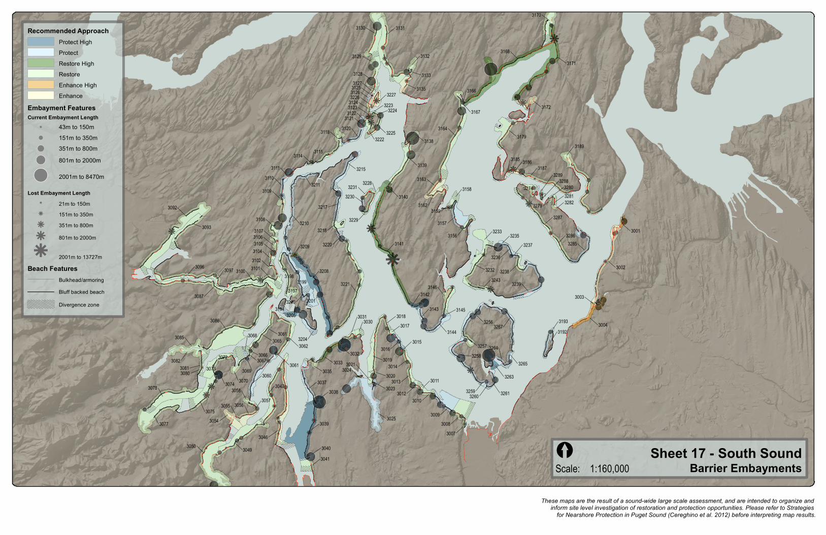
Sheet 17 - South SoundScale: 1:160,000

Recommended ApproachProtect HighProtectRestore HighRestoreEnhance HighEnhance

Embayment FeaturesCurrent Embayment Length

!( 43m to 150m!( 151m to 350m!( 351m to 800m!( 801m to 2000m

!( 2001m to 8470m

Lost Embayment Lengthk 21m to 150mk 151m to 350mk 351m to 800m

k 801m to 2000m

k 2001m to 13727mBeach Features

Bulkhead/armoringBluff backed beach

Divergence zone

Barrier Embayments[

These maps are the result of a sound-wide large scale assessment, and are intended to organize and inform site level investigation of restoration and protection opportunities. Please refer to Strategies

for Nearshore Protection in Puget Sound (Cereghino et al. 2012) before interpreting map results.