Embed Size (px)
Citation preview

2003 Technical Report #12
Baseline Avian Surveys
KAGMAN CONSERVATION AREA 2002/03
Conducted by
CNMI Department of Lands and Natural Resources Division of Fish and Wildlife
Wildlife Section P.O. Box 10007, Lower Base
Saipan, MP 96950
Justine de Cruz, Laura Williams, Vicente Camacho, and Juan Salas
December 2002 - February 2003

Kagman Wildlife Conservation Area Surveys
BASELINE AVIAN SURVEYS OF KAGMAN WILDLIFE CONSERVATION AREA 2002/03
DECEMBER 2002 - FEBRUARY 2003
by Justine de Cruz, Laura Williams, Vicente Camacho, and Juan Salas
Division of Fish and Wildlife Wildlife Section
P.O. Box 10007, Lower Base Saipan, MP 96950
Executive Summary
Forest birds were surveyed using Variable Circular Plot (VCP) methodology on 17 - 20 December 2002, 22 - 23 January, and 4 February 2003. Teams of one to two people surveyed 60 point count stations along 13 transects within the Kagman Wildlife Conservation Area. Density estimates and population abundance for each species were calculated using the computer statistical program DISTANCE (version 3.5) available on the web. In calculating forest bird population abundances we estimated that approximately 179 ha of the Protected Area are used by forest birds at this time.
A total of 847 birds were detected during the VCP surveys of the Kagman Wildlife Conservation Area in 2002 - 2003. On average, 13.7 birds were counted per station, with only four feral and domestic roosters and chickens observed. On average, the density of forest birds was less in the Kagman Conservation Area than in other protected areas on the island of Saipan.
Of the 16 species of birds counted during the survey, three White-tailed tropicbird (Phaethon lepturus), five Brown Noddies (Anous stoJidus), and 77 White terns (Gygis alba) were among the seabirds recorded incidentally.
Populations of the remaining forest birds appeared to be robust during the survey period. The most plentiful were the Bridled white-eye (Zosterops consp;cillafus), Rufous fantail (Rhipidura fufifrons) , and Golden white-eye (Cleptornis marcher). Collared kingfishers (Halcyon chloris), Micronesian starlings (Aplonis opaca), and Micronesian honeyeaters (Myzomela rubratra) were common. Abundance of Philippine turtle-doves (StreptopeJia bitorquata), Eurasian tree-sparrows (Passer montanus), endangered Nightingale reed-warblers (Acrocephalus lusc;n;a), and White-throated ground-doves (Gallicolumba xanthonura) were relatively low, but consistent with expectations. The endangered Micronesian megapode (Megapodius laperouse) and endangered Mariana swiftlet (Aerodramus bartschl)
2003 Technical Report #12 2

Kagman Wildlife Conservation Area Surveys
were not detected during the survey, but the latter have been observed foraging frequently over this forest on other occasions. Mariana fruit-doves (Ptilinopus roseicapilla) occurred less often than expected given their abundance in other forested reserves on Saipan.
Juvenile Mariana fruit-dove
I. Introduction
The Kagman Conservation Area was created by the Department of Lands and Natural Resources (DLNR) after almost 10 years of lobbying the then Marianas Public Land Corporation (currently the Mariana Public Lands Authority [MPLA]) by the Division of Fish and Wildlife (DFW). A grant of public domain lands for the Conservation Area was made to DLNR in December 1991. The purpose of the transfer of public lands was to set aside a sanctuary exclusively for wildlife and to improve agricultural and wildlife resources to meet the needs of the residents of the Commonwealth. The Kagman Conservation Area is described by DLS Check No. 019 G 00 as Lot No. 019 G 01 containing an area of 179.16 ha (Fig. 1).
2003 Technical Report #12

Kagman Wildlife Conservation Area Surveys
TlllF-==--crank Beach
orbidden Island Lookout
~Ik-'-~----=-----'crrail to beach
Old forest road
Figure 1. Boundaries, prior uses (forestry mitigation plots and grazing permits are indicated by hatching), and current recreational sites in the Kagman Wildlife Conservation Area.
The area incorporated into the Kagman Conservation Area includes Tank Beach (also known as Unai Laolao Kattan) on the northeast and extends along the east coast of Saipan past Puntan Hakmang to a point halfway between Puntan Hakmang and Puntan Bapot. It is bounded on the west by the recently constructed Kagman Homestead Areas, roads, schools, and public recreation areas as well as a golf course (Laolao Bay Golfcourse) leased by the Shimizu Corporation. The Kagman Conservation Area is bounded on the northeast, east, and south by the ocean and by the Forbidden Island Sanctuary.
Prior to the establishment of the Kagman Conservation Area in 1991 and throughout the 1980-1990's, at least one third of the area was leased to private individuals under temporary grazing permits. Several of these grazing permits were renewed until 1999. However, proposals to create orchards of fruit trees on a large section of land including Puntan Laolao Kattan were rebuffed in 1991. Further disturbances to the natural regime included reforestation plots planted as
2003 Technical Report #12 4

Kagman Wildlife Conservation Area Surveys
mitigation for the Air Force Radar installation on Saipan (PACBAR plots) in 1989 and maintained through 1993. With the creation of the adjacent Kagman Homestead Areas, MPLA constructed a barbed wire fence along a short portion of the ConseNation Area boundary including the area of Tank Beach in 2000, which has precluded traffic driving on the beach since that time. Signage indicating the appropriate uses of the Tank Beach and Forbidden Island areas was erected by DLNR in 2002. Interpretive signs focused on wildlife species were installed by DFW in 2003 at Tank Beach parking area and Forbidden Island Lookout.
View to the southern portion of the Kagman ConseNation Area including Forbidden Island Sanctuary and Lookout, and the beginning of the Kagman
Homestead Area.
Historically, the area is rich in archeological sites that have not been well documented (G. Cabrera, CNMI-Historic PreseNation Office, in. /itt.). Ancient Chamorro ruins exist along the cliff lines and shoreward areas of the reseNe, and the area was under agricultural usage prior to World War" during the Japanese Era. Maps of the extent of agricultural transformation of the Kagman area exist in the archives of the Northern Mariana College, and physical remnants of the Japanese and American occupations and wartime activities are widespread through the ConseNation Area.
2003 Technical Report #12 5

Kagman Wildlife Conservation Area Surveys
Soil surveys of the Kagman Are were completed in 1986 (Young 1989). There are seven soil types listed for the area, two of which are volcanic in origin (the Afayan Variants) and the remainder are very shallow, well drained soils formed over a limestone substrate (Table 1). The limestone base is jagged and frequently protrudes well above the soil surface in towering flanges of knife sharp rock. The area is known for its many caves and deep rifts, and the rugged topography includes several level plateaus and cliff lines.
Cliff lines, rifts, jagged limestone outcroppings, caves, and pockets of outstanding native forest are characteristic of the Kagman Conservation Area.
Table 1. Soils and their recommended uses in the Kagman Conservation Area after Young 1989).
# Name Slope (%)
Recreational Uses1
Sanitation Wildlife Uses
1 Afayan Variant Rock Outcrop
15-30 Trails with extensive modifications
No Herbs Openland wildlife
2 Afayan Variant Rock Outcrop
30-60 None No Herbs Openland wildlife
10 Chinen Clay Loam 0-5 Trails with extensive modifications
No Herbs, shrubs, trees Openland and Forest wildlife
11 Chinen Clay Loam 5-15 Trails with No Herbs, shrubs, trees
2003 Technical Report #12 6

Kagman Wildlife Com
# Name Slope (%)
Recreational Uses1
Sanitation Wildlife Uses
extensive modifications
Openland and Forest wildlife
50 Takpochao-Rock Outcrop complex
3-15 None No Trees and shrubs Forest wildlife2
51 Takpochao-Rock Outcrop complex
15-30 None No Trees and shrubs Forest wildlife2
52 Takpochao-Rock Outcrop complex
30-60 None No Trees and shrubs Forest wildlife2
1 Recreational uses conSidered Included camping areas, pICniC areas, ~Iaygrounds, paths and trails.
Soils are poor for herbs and openland wildlife.
Figure 2. Approximate locations of soil types. See Table 1 for names and characteristics of soils delineated by numbers (map after Young 1989).
2003 Technical Report #12 7

Kagman Wildlife Conservation Area Surveys
The volcanic soil series occupies the southern portion of the Conservation Area, including Forbidden Island, and is very resistant to weathering. Hazard of erosion is severe on the volcanic soils and although they develop hard crusts, they can easily be chipped with a spade. Where trails are built in these areas, the risk of gully erosion is great. Over two-thirds of the area lies at a greater than 15% slope and thus is prone to high water run off and erosion. The soils are poorly suited for recreational development, and the vegetation the soils support ranges from grasslands (on Afayan Variant soils) to native forest on Takpochao soils (Fig. 2 and Table 1).
Early inventories of wildlife and vegetation in the Kagman Conservation Area are scant. A memo from DFW Fisheries Specialist David Aldan to the head of DFW in 1984 lists species diversity (Table 2) with no indication of population size in the at-that-time proposed Conservation Area. The boundaries of the proposed area were revised several times before declaration of the Area in 1991.
Table 2. Species present in the Kagman Conservation Area in 1984 (after a memo from DFW Fisheries Specialist David Aldan).
SPECIES· COMMON NAME ENGLISH NAME SEABIRDS Anous stolidus Fahang dankolo Brown noddy Sula leucogaster Lu'ao Brown booby Pheathon lepturus FaQPiapaka White-tailed tropicbird Pheathon rubricauda FaQpi Red-tailed tropicbird Gygis alba Chunge White tern TERRESTRIAL BIRDS Rhi/Jidura rufifrons Na'abak Rufous fantail Cleptornis marchei Canario Golden white-eye Myzomela rubratra Egigi Micronesian honeyeater Zosterops conspicillata Nosa Bridled white-eye Acrocephalus luscinia Gaga karisu Nightingale reed-warbler Aerodramus barlschii ChachaQuak Mariana swiftlet Ixobrychus sinensis Kakak Yellow bittern Halcyon chloris Sihek Collared kingfisher Aplonis opaca Sali Micronesian starlinq Pfilinopus roseicapilla Paluman totot Mariana fruit-dove Gallicolumba xanthonura Paluman apaka White-throated ground-
dove Streptopelia bitorquota Paluman apu Philippine turtle-dove INVERTEBRATES Birgus latro Ayuyu Coconut crab VEGETATION Arlocarpus altiUs Lemai Seedless breadfruit
2003 Technical Report #12 8

Kagman Wildlife Conservation Area Surveys
SPECIES· COMMON NAME ENGLISH NAME Morinda citrifolia Lada [noni] Indian mulberry Ficus tinctoria Hodda Dyer's fig Ficus prolixa Nunu Banyan, Strangler fig Psycotria mariana Aploghating --Pouteria obovata Lalaha --Neisosperrna oppositifolia
Fagot --
Guamia mariannea Peipei Paipai Carica papaya Papaya Papaya Premna obtusifolia Ahgao False elder Euaenia palumbus Agatelang --Passiflora foetida - Love-in-a-mist [wild
passionfruit] Terminalia catappa Talisai Pacific almond Ochrosia mariannensis Langiti Lipstick tree Pipturus argenteus Amahadyan Silvery pipturus Melanolepis multiglandulosa
Alum -
*Deslgnatlons have been updated to reflect current taxonomIc usage.
Forbidden Island, just off the coast of the Kagman Conservation Area, was designated by the Commonwealth legislature as a sanctuary for wildlife and marine life by Public Law No. 12-46 in February 2001. The purpose of the sanctuary is twofold: (1) to serve as a refuge where wildlife and marine species can propagate for the repopulation of depleted areas of the island and lagoon, and (2) to serve as educational laboratories for students, teachers and research groups for the study of terrestrial and marine species. The terrestrial boundaries of the sanctuary overlap with the seaward boundaries of the conservation area on the southeast.
The law creating the Forbidden Island Sanctuary permits instructional signage to be erected, as well as marking and fencing the terrestrial boundary and the deployment of buoys to mark the seaward perimeter of the sanctuary. It allows for the installation of gates, railings for safety purposes, trail marking, and the building of rest areas and bathroom facilities. The law charges the Division of Fish and Wildlife (DFW) with monitoring the sanctuary both for scientific and enforcement purposes, and charges MPLA, Coastal Resource Management Office, Mariana Visitors Authority, and DFW with working cooperatively to develop the sanctuary as a model for conservation throughout the Pacific.
2003 Technical Report #12 9

Kagman Wildlife Conservation Area Surveys
Ayuyu (Coconut crabs) are among the many wildlife resources in the Kagman Conservation Area.
Activities permissible within the sanctuary include educational field trips, documentary filming, hiking, picnicking and other activities that do not impact detrimentally on wildlife conservation. Activities that are expressly prohibited in the sanctuary include harassing and/or removal of plants, wildlife, turtles, fish and marine species, fishing in any form, operation of jet skis, walking on exposed reef, and harvesting shellfish. At this writing, no management plan exists for the Kagman Conservation Area that defines use areas. It is expected that the baseline avian surveys reported here will contribute to the delineation of specific use zones (e.g., areas dedicated to the use of the public for recreational activities, areas set aside as no-use zones for wildlife and research purposes) in a future management plan for the Conservation Area. The avian baseline surveys conducted by DFW in December 2002 - February 2003 are detailed in the following report with results of vegetation and herpetological surveys to be added as analysis of survey data is completed.
II. Forest Bird Surveys
Methods for surveys and analysis Forest birds were surveyed using Variable Circular Plot (VCP) methodology
on 17 - 20 December 2002,22 - 23 January, and 4 February 2003. Teams of one to two people surveyed 60 point count stations along 13 transects within the Kagman Wildlife Conservation Area. Listening stations were located 150 m distant from each other along transects set 200 m apart (Fig. 3).
2003 Technical Report #12 10

Kagman Wildlife Conservation Area Surveys
\'. \ .
Figure 3. Kagman Conservation Area sampling transects established in December 2002.
Sampling stations were not permanently marked but may be approximately relocated using the GPS coordinates listed in Appendix 1. One person from each team counted birds both visually and by song, estimating the lateral distance to each bird detected. Calibration exercises conducted prior to beginning the survey were intended to reduce variability among observers. Surveys were conducted from dawn until 1000 hours. Vegetation was described for each listening station and results of the habitat survey are reported separately.
Density estimates for each species were calculated using the computer statistical program DISTANCE (version 3.5) available on the web. Data for each species were examined using histograms and truncated such that 90-95% of the observations were used to fit the mathematical models. Data were grouped into intervals that allowed a good fit to the half-normal model (intervals and number of groups were different for each species). The X: goodness-of-fit test for all species with the exception of Golden white-eyes (P > 0.6) and Mariana fruitdoves (P > 0.7) indicated a very good fit between model and data (P > 0.9). Data
2003 Technical Report #12 11

Kagman Wildlife Conservation Area Surveys
from this survey were grouped with data from other forest surveys conducted on Saipan and Aguiguan and were run simultaneously to augment the number of detections (sample size) for each species where necessary. Densities were calculated for each species and for each survey independently.
In calculating forest bird population abundances we estimated that approximately 179 ha of the Protected Area are used by forest birds at this time. From aerial photos it is known that some portion of this area was under sugar cane production in the 1930's and 1940's, with an old road that ran out to Puntan Laolao Kattan. The presence of extensive secondary forest attests to the regrowth of the forest since that period.
Results and discussion A total of 847 birds were detected during the VCP surveys of the Kagman
Wildlife Conservation Area in 2002 - 2003. On average, 13.7 birds were counted per station, with only four feral and domestic roosters and chickens observed.. Of the 16 species of birds counted during the survey, three White-tailed tropicbird (Phaethon lepturus), five Brown Noddies (Anous stolidus), and 77 White terns (Gygis alba) were among the seabirds recorded incidentally.
Table 3. Numbers of forest birds detected 17 December 2002 - 4 February 2003 in the Kagman Conservation Area (n = 60 stations). Counts are expressed both as total number of detections for the species and as mean number of the species detected per station ± one standard deviation (SO).
Bird Species Total count mean
# birds/station (±sdl Bridled white-eye 405 6.5 4.83 Rufous fantail 108 1.7 1.96) White tern 77 1.212.00 Golden white-eye 71 1.1 1.71 Collared kinQfisher 56 0.9 1.10 Micronesian starlinQ 32 0.5 1.05 Philippine turtle-dove 23 0.4 1.00 Micronesian honeyeater 20 0.3 (0.65 Mariana fruit-dove 15 0.2 0.50 Eurasian tree-sparrow 12 0.2 1.52 Nightingale reed-warbler 8 0.1 0.38 White-throated ground-dove 5 0.1 0.38 Brown noddy 5 0.1 0.64 Domestic fowl 4 0.06 (na Yellow bittern 3 0.05 0.28) White-tailed tropicbird 3 0.05 0.375) Micronesian meqapode Not detected -
2003 Technical Report #12 12
Kagman Wildlife Conservation Area Surveys
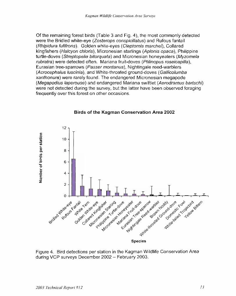
Of the remaining forest birds (Table 3 and Fig. 4), the most commonly detected were the Bridled white-eye (Zosterops conspicillatus) and Rufous fantail (Rhipidura fufifrons). Golden white-eyes (Cleptornis marche/), Collared kingfishers (Halcyon chloris), Micronesian starlings (Aplonis opaca), Philippine turtle-doves (Streptopelia bitorquata) and Micronesian honeyeaters (Myzomela rubratra) were detected often. Mariana fruit-doves (Ptilinopus roseicapilla), Eurasian tree-sparrows (Passer montanus), Nightingale reed-warblers (Acrocephalus luscinia), and White-throated ground-doves (Gal/icolumba xanthonura) were rarely found. The endangered Micronesian megapode (Megapodius laperouse) and endangered Mariana swiftlet (Aerodramus bartschl) were not detected during the sUNey, but the latter have been obseNed foraging frequently over this forest on other occasions.
Birds of the Kagman Conservation Area 2002
12 c 0 ~ 10 ~ .. G) Q. 8 tn 'E 1i 6-..0G) .0 4 E z ~
2
0
Figure 4. Bird detections per station in the Kagman Wildlife ConseNation Area during VCP sUNeys December 2002 - February 2003.
2003 Technical Report #12 13

Kagman Wildlife Conservation Area Surveys
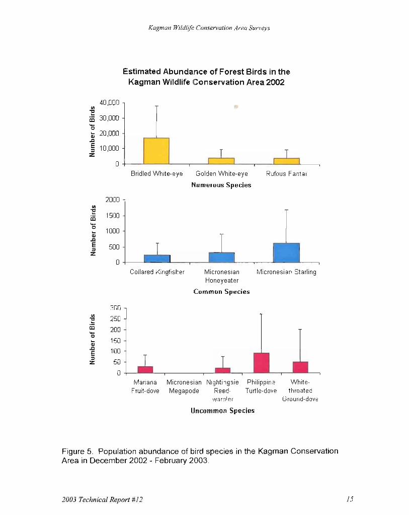
Populations of all of the forest birds in the Kagman Wildlife Conservation Area appeared to be robust during the survey period (Table 4 and Fig. 5). Bridled white-eyes, Rufous fantails, and Golden white-eyes were plentiful. Micronesian starlings, Micronesian honeyeaters, and Collared kingfishers were common. Abundance of Philippine turtle-doves, White-throated ground-doves, and the endangered Nightingale reed-warbler were relatively low, but consistent with expectations. Mariana fruit-doves, however, occurred less often than expected given their abundance in other forested reserves on Saipan.
Table 4. Bird density per hectare and estimated abundance of each species in the Kagman Conservation Area, 2002-2003. Calculated densities and the Conservation Area-wide population estimates are followed by 95% confidence intervals based on an estimated 179 ha of forested land.
Bird Species DENSITY
Birds/ha 2001 (95% CI) ABUNDANCE
Population estimate(95% CI) Bridled white-eye 94.41 (75.91 -117.40) 16,908 (13,596 - 21,027) Rufous fantail 22.58 (16.92 - 30.13) 4,044 (3,030 - 5,397) Golden white-eye 21.22 (13.9 - 32.17) 3,800 (2,506 - 5,761) Micronesian starling
3.44 (1.99 - 5.95) 617 (357 - 1,066)
Micronesian honeyeater
1.80 (1.00 - 3.25) 323 (180 - 582)
Collared kingfisher 1.37 (0.90 - 2.09) 246 (161 - 374) Philippine turtledove
0.52 (0.26 - 1.01) 92(47-181)
White-throated ground-dove
0.28 (0.09 - 0.85) 50 (17 - 151)
Mariana fruit-dove 0.16 (0.09 - 0.30) 29 (16 - 53) Nightingale reed-warbler
0.14 (0.06 - 0.29) 24 (11 - 52)
Density of Mariana fruit-doves in the Kagman Conservation Area 2002/03 (0.16 birds/ha) was significantly lower than in the Bird Island Wildlife Preserve 2001 (0.33 birds/ha) (Cruz et al. 2003) and thus population abundance in the larger protected area was surprisingly low. However, it is difficult to determine the lateral distance of a calling dove during surveys (Craig et al. 1992), and differences in calling activity over the year plus differences in forest structure between the two sites (differences that impact the attenuation of sound waves) may have contributed to the lower detection rate for fruit-doves in the Kagman site.
2003 Technical Report #12 14
Kagman Wildlife Conservation Area Surveys
40,000 (II
"'Cl
~ 30,000 .... Cl
; 20,000 .J:2
§ 10,000 z
Estimated Abundance of Forest Birds in the Kagman Wildlife Conservation Area 2002
T T o +-_....L..-__..1--_-r--__1 _-...I1 1 ..1--_-..1.- L....-_-.--_...J. 1
Bridled White-eye Golden White-eye Rufous Fantail
Numerous Species
Collared Kingfisher Micronesian Micronesian Starling Honeyeater
Common Species
300
250
200 150 100
Z ::=
50
Mariana Micronesian Nightingale Philippine WhiteFruit-dove Megapode Reed- Turtle-dove throated
warbler Ground-dove
Uncommon Species
2000 (II
"'Cl... 1500CD .... Cl
1000... Ql
.J:2 E 500... z
0
O+---L.--r-----,-----,----J
Figure 5. Population abundance of bird species in the Kagman Conservation Area in December 2002 - February 2003.
2003 Technical Report #12 15

Kagman Wildlife Conservation Area Surveys
Nightingale reed-warbler density also appeared to be low for the island of Saipan. Reed-warbler density was 0.14 birds/ha (95% CI = 0.06 - 0.29) in the Kagman Wildlife Conservation Area in December 2002 - February 2003 compared with 0.32 birds/ha (95% CI =0.12 - 0.83) in the Bird Island Wildlife Preserve in December 2001 (Cruz et al. 2003), and 0.41 birds/ha (95% CI = 0.28 - 0.59) in the Saipan Upland Mitigation Bank in March 2003 (J. Cruz, unpublished data). Because the confidence intervals overlap, there is no statistically significant difference in reed-warbler density among the three areas. However, habitat differences between the southern area dominated by native forest and the two northern areas dominated by tangantangan forests may contribute to the paucity of reed-warbler detections in the Kagman Wildlife Conservation Area. The endangered Nightingale reed-warbler is known to nest infrequently in native forest and to be a bird adapted to mosaics of field and secondary forest (Craig 1992). The Kagman Wildlife Conservation Area may support fewer reed-warblers than other areas because the intact native forest canopy is more extensive there.
Reports of small Mariana fruit bat colonies in less accessible locations of the Kagman Conservation Area are persistent.
2003 Technical Report #12 16

Kagman Wildlife Conservation Area Surveys
III. Other Observations
Small mammal, herpetological, and vegetation surveys were also conducted in the Kagman Wildlife Conservation Area to provide baseline information for future decisions regarding the management of the Area. Several unique forest types were discovered during these surveys, as well as many sites of archeological and historic importance. At this writing, the data from these additional surveys are being analyzed but, due to time constraints, they are not ready to be presented in this report. A more comprehensive technical report including the results of analysis for the above surveys will be prepared by DFW-Wildlife Section in the near future.
IV. Management Recommendations
The Kagman Conservation Area appears to be recovering from past fragmentation by roads, military and tourist facilities, agricultural clearings, grazing leases, and forestry plots. It contains a wealth of historic artifacts as well as stunning vistas from its cliff edges. The adjacent Forbidden Island Sanctuary protects one of the most scenic and popular beach and marine areas of Saipan. The Wildlife Conservation Area, adjacent to one of the most populated areas of Saipan, has been effectively isolated by the current homestead and commercial development on the Kagman peninsula. Threats to the Conservation Area, in part, are a result of this double insular effect: isolation of this forested area within an already isolated oceanic island.
The Kagman Conservation Area is at active risk from silvicultural and agricultural encroachments by homesteaders along its landward borders; encroachment from the mining of limestone in an adjacent quarry operated by the Mayor of Saipan; forest edge effects including increased drying, windfalls, and invasion by edge and invasive plant species; poaching of marine turtles and their nests, coconut crabs and fruit bats within the Protected Area; erosion of trails constructed on poor soil substrates; vehicular traffic on the beach; and overuse as a recreational area.
The following recommendations to improve protection and enhance forest and wildlife resources are based on past use of the area, the structure of the substrate, and the biological findings of the current surveys:
1. Protect the continuity of the forests within the Kagman Wildlife Conservation Area by:
a. Fencing the Protected Area's boundaries; b. Posting the boundaries to inform the public of the Conservation
Area's physical extent; c. Maintaining informational signage to inform the public of the
benefits of the Protected Area and the restrictions of its use;
2003 Technical Report #12 17

Kagman Wildlife Con:
d. Prohibiting further road building; e. Restricting the building of further tourist and recreational
facilities to those sites that are currently disturbed in the southern half of the Protected Area (e.g., Forbidden Island Lookout and trail) and to the Tank Beach area.
f. Limiting plantings along roadsides and in recreational use areas to native species (that is, no non-native plantings).
2. Improve erosion control along current road to Forbidden Island Lookout and along the trail to the beach.
3. Restrict tourist and other recreational facilities to those areas that are already developed.
4. Improve protection and the monitoring of nesting sea turtles on Tank Beach.
5. Restrict uses of the remaining intact areas of the Protected Area to those supporting scientific research and conservation.
6. Prohibit further manipulation of currently forested areas so that forest continuity and health is maintained at least in its current status.
7. Implement a management plan for the area that strictly protects the current forests and restricts recreational uses to those existing clearings and soil types that can support them.
Silvicultural and agricultural encroachment, as well as over use of the Forbidden Island Lookout and Beach trail areas, are among the risks to forest integrity in the
Kagman Conservation Area.
2003 Technical Report #12 18

Kagman Wildlife Conservation Area Surveys
V. Acknowledgements
The authors would like to thank the Enforcement Section's Conservation Officers and the CNMI Historic Preservation Office for their assistance during the survey period. We are indebted to a grant under Federal Aid (Pitman-Robertson funds) to Wildlife Conservation and Restoration for financial support while conducting the surveys and for support during the analysis of data and the writing of this report.
VI. Literature Cited
Craig, RJ. 1992. Territoriality, habitat use and ecological distinctness of an endangered Pacific island reed-warbler. Journal of Field Ornithology 63:436444.
Craig, RJ., R Chandran, and A. Ellis. 1992. Bird populations of Aguiguan: a ten year update. In, The Aguiguan Expedition, pp. 8-15, Proceedings: Marianas Research Symposium, R J. Craig (ed), Northern Marianas College, Saipan, MP.
Cruz, J., L. Williams, N. Johnson, V. Camacho, and J. Salas. 2003. Baseline Avian Surveys, Bird Island Wildlife Preservation Area 2001. CNMI-Division of Fish and Wildlife Technical Report #11. Pp. 14.
Young, F. J. 1989. Soil survey of the islands of Aguijan, Rota, Saipan, and Tinian, Commonwealth of the Northern Mariana Islands. USDA, Soil Conservation Service, National Cooperative Soil Survey. Pp. 166 plus maps.
2003 Technical Report #12 19

Kagman Wildlife Conservation Area Surveys
APPENDIX 1
Kagman Conservation Area vep Point Count Station GPS Locations
Error (plus or minus) Island Transect Station N E meters ~aipan 1 1 369954 1677367 5 Saipan 1 2 370078 1677289 6 Saipan 1 3 370208 1677206 9 Saipan 1 4 370338 1677125 9 Saipan 1 5 376470 1677044 8 Saipan 1 6 370593 1677018 5 Saipan 2 1 369776 1677274 8 Saipan 2 2 369901 1677171 22 Saipan 2 3 369996 1677092 11 Saipan 2 4 1370128 1677009 17 Saipan 2 5 reception poor Saipan 3 1 369670 1676997 Saipan 3 2 369762 1676925 Saipan 3 3 369797 1676909 )aipan 4 1 369576 1676732 :>aipan 4 2 369702 1676649 ~aiDan 5 1 369495 1676435 ~aipan 5 2 369603 1676350 ~aiDan 5 3 369719 1676266 ~aipan 6 1 369337 1676224 ~aipan 6 2 369452 1676150 ~aipan 6 3 369578 1676066 )aipan 6 4 369723 1675963 ;aipan 7 1 369439 1675948 ;aipan 7 2 369349 1675849 ~aipan 7 3 369233 1675746 )aipan 7 4 369146 1675641 ;aipan 7 5 369036 1675522 ;aipan 7 6 368927 1675406 ~aipan 8 1 369480 1675790 ~aipan 8 2 369607 1675742 ~aiDan 9 1 369609 1675852 9 ~aipan 9 2 369678 1675735 4 ~aipan 9 3 369740 1675602 8 ~aipan 9 4 369772 1675480 6 Saipan 9 5 369804 1675555 9 Saipan 9 6 369878 1675393 13 Saipan 10 1 369836 1677640 10
2003 Technical Report #12 20

Kagman Wildlife Conservation Area Surveys
Error (plus or minus) Island Transect Station N E meters lSaipan 10 2 reception poor lSaipan 10 3 reception poor lSaipan 10 4 370177 1677376 10 Saipan 10 5 370283 1677284 13
aipan 10 6 370409 1677200 10 aipan 10 7 370544 1677137 8 aipan 11 1 369733 1677730
lSaipan 11 2 36960E 1677824 lSaipan 11 3 369522 1677910 Saipan 11 4 369413 1677998 lSaipan 11 5 not recorded lSaipan 11 6 not recorded Saipan 12 1 369293 1675944 Saipan 12 2 369159 1675879 )aipan 12 3 369045 1675777 :iaipan 12 4 368901 1675689 )aipan 12 5 368827 1675605
Saipan 12 6 368747 1675499 Saipan 13 1 369731 1676090 Saipan 13 2 369305 1675965 Saipan 13 3 369840 1676151 Saipan 13 4 369937 1676460 Saipan 13 5 370067 1676282 Saipan 13 6 370139 1676376
2003 Technical Report #12 21