Embed Size (px)
Citation preview
Basic Seismological Characterization for
Lincoln County, Wyoming
by
James C. Case, Rachel N. Toner, and Robert Kirkwood Wyoming State Geological Survey
November 2002
BACKGROUND Seismological characterizations of an area can range from an analysis of historic seismicity to a long-term probabilistic seismic hazard assessment. A complete characterization usually includes a summary of historic seismicity, an analysis of the Seismic Zone Map of the Uniform Building Code, deterministic analyses on active faults, “floating earthquake” analyses, and short- or long-term probabilistic seismic hazard analyses. Presented below, for Lincoln County, Wyoming, are an analysis of historic seismicity, an analysis of the Uniform Building Code, deterministic analyses of nearby active faults, an analysis of the maximum credible “floating earthquake,” and current short- and long-term probabilistic seismic hazard analyses.
Historic Seismicity in Lincoln County
The enclosed map of “Earthquake Epicenters and Suspected Active Faults with Surficial Expression in Wyoming” (Case and others, 1997) shows the historic distribution of earthquakes in Wyoming. Numerous magnitude 2.0 and greater earthquakes have been recorded in Lincoln County. Most of these were relatively small magnitude events and subsequently, not felt. These earthquakes are discussed below. The first earthquake that was reported in Lincoln County occurred on March 31, 1915. This intensity IV earthquake, located approximately 3.5 miles northeast of Bedford, shook buildings in the area. No significant damage was reported, however (Humphreys, 1915). Only one earthquake was recorded in the county in the 1920s. On December 6, 1921, an intensity III earthquake occurred approximately 8 miles northeast of Afton. No damage was reported.
2
Several earthquakes occurred in Lincoln County in the 1930s. The first took place on June 12, 1930, approximately 9 miles southwest of Afton. This intensity VI, magnitude 5.8 (estimated) event was felt by most residents in the Star Valley and caused damage in Grover. Plaster walls, a brick building, and a swimming pool in the Grover area cracked. Interestingly, this event also stopped clocks on the west walls of buildings. (Neumann and Bodle, 1932). Numerous aftershocks continued in the area through June 16, 1930 (Reagor, Stover, and Algermissen, 1985). Intensity II and intensity III earthquakes occurred in the same area as the June 12 event on September 19, 1930, and September 21, 1930, respectively (U.S.G.S. National Earthquake Information Center). Another intensity III earthquake and another intensity II earthquake were recorded in the same location on November 16, 1930 (Neumann and Bodle, 1932) and June 8, 1932 (U.S.G.S. National Earthquake Information Center), respectively. No damage was reported from any of these events. On October 24, 1936, two earthquakes occurred in western Wyoming. The U.S.G.S. National Earthquake Information Center reported these two intensity III earthquakes as occurring in Sublette County. The original reference and description of these events, however, indicates that these earthquakes originated in the Star Valley of Lincoln County (Neumann, 1936). The epicenter of this earthquake will therefore be tentatively located approximately 6-8 miles northwest of Afton. No damage was reported. The area approximately 9 miles southwest of Afton again experienced intensity III earthquakes on November 29, 1938, December 1, 1938, and December 5, 1938 (U.S.G.S. National Earthquake Information Center). No damage was associated with these events. On October 8, 1944, an intensity IV earthquake occurred in the same area as the 1930s earthquakes described above. Several residents of Grover felt the event and reported that the earthquake had a trembling motion with an abrupt onset. Loose objects rattled and buildings creaked (Bodle, 1946). The U.S.G.S. National Earthquake Information Center detected an earthquake of no specific magnitude or intensity on September 3, 1949, approximately 14 miles southwest of La Barge. No one reported feeling this earthquake. Two earthquakes were recorded in northern Lincoln County in the 1950s. A magnitude 3.0 event occurred on May 8, 1955, approximately seven miles east-northeast of Afton. No damage was associated with this earthquake. On November 3, 1957, a magnitude 3.7, intensity IV earthquake was recorded approximately 18 miles south-southwest of Afton. This event was felt by several residents of Geneva, Idaho (Brazee and Cloud, 1959). Although numerous earthquakes occurred in Lincoln County during the 1960s, none caused any significant damage. Earthquakes of no specific magnitude or intensity were recorded on June 25, 1964, approximately 14 miles northeast of Alpine, and on July 10, 1964, approximately 13 miles east-northeast of Bedford (U.S.G.S. National Earthquake Information Center). On September 17, 1964, a non-damaging magnitude 4.0 earthquake was detected approximately 10 miles northeast of Afton. The U.S.G.S. National Earthquake Information Center recorded another earthquake of no specific magnitude or intensity on May 20, 1965. This event was centered approximately 19 miles east-southeast of Alpine. A magnitude 3.3 earthquake occurred on August 22, 1965, approximately 21 miles west-northwest of La Barge. On October 27, 1965, a magnitude 2.5 event was detected approximately 18 miles southwest of La Barge. A non-
3
damaging, magnitude 3.9 earthquake occurred in Lincoln County on December 24, 1965. This earthquake’s epicenter was located approximately 12 miles east-northeast of Afton. Several earthquakes also occurred in Lincoln County in 1966. The first took place on July 12, 1966, approximately 17 miles northeast of Cokeville. No damage was reported from this magnitude 2.5 earthquake. On October 4, 1966, a magnitude 3.8 earthquake occurred approximately 13 miles south-southwest of Kemmerer. It is suspected that an explosion or seismic line activity may have caused this event. A few days later, a magnitude 4.4 earthquake occurred on October 8, 1966. This non-damaging earthquake was centered approximately 3 miles north-northeast of Alpine. According to the U.S.G.S. National Earthquake Information Center, no one reported feeling this event. Another earthquake attributed to an explosion was recorded on October 14, 1966, approximately 8 miles west-northwest of Kemmerer. This same area experienced a magnitude 3.7 earthquake of tectonic origin on October 27, 1966. On November 3, 1966, a magnitude 2.8 event was detected approximately 14.5 miles north of Kemmerer (University of Utah Seismograph Stations). This event was followed by a magnitude 2.5 earthquake on November 18, 1966. Its epicenter was located approximately 18.5 miles north-northeast of Kemmerer. The first event to occur in Lincoln County in 1967 took place on February 27, 1967, approximately 18 miles southwest of La Barge. This magnitude 3.7 earthquake was later attributed to an explosion in the area. On March 10, 1967, another magnitude 3.7 earthquake occurred approximately 15.5 miles south-southwest of La Barge. Residents in the area reported feeling this event, but no damage was reported (U.S.G.S. National Earthquake Information Center). A magnitude 4.0 earthquake was detected in northern Lincoln County on June 26, 1967, approximately 5 miles north of Thayne. On August 29, 1967, a magnitude 2.5 earthquake occurred approximately 9 miles north-northwest of Kemmerer. The last event to occur in 1967 took place on September 11, 1967. This earthquake of no specific magnitude or intensity was located in the same area as the June 26 event. Five earthquakes occurred in Lincoln County in 1968. The first was detected on February 20, 1968. This magnitude 3.7 earthquake was centered approximately 5 miles southwest of Kemmerer. On May 17, 1968, a magnitude 2.8 event occurred roughly 16 miles southwest of La Barge. A magnitude 3.0 earthquake was recorded on June 14, 1968. Its epicenter was located approximately 11 miles northeast of Kemmerer. Magnitude 2.5 and magnitude 2.6 earthquakes occurred in the county on July 30, 1968 and November 14, 1968, respectively. The July 30 event was centered approximately 21 miles west of La Barge, while the November 14 event was centered approximately 19 miles southwest of La Barge. No damage was reported from any of the 1968 events. Several earthquakes took place in the county in 1969, the first of which occurred on February 4. This magnitude 2.5 event was centered approximately 15 miles north-northeast of Kemmerer. On August 27, 1969, a magnitude 4.2, intensity III earthquake was reported approximately 7 miles east-northeast of Bedford. Residents of Auburn reported feeling this earthquake, but no damage was caused. On the same day, a magnitude 3.9 earthquake was detected roughly 15 miles east-northeast of Thayne. No one reported feeling this event (U.S.G.S. National Earthquake
4
Information Center). A second 3.9 earthquake occurred a few days later on August 30, 1969. This event was located in northeastern Lincoln County, approximately 19 miles southeast of Alpine. Again, no one reported feeling this event (U.S.G.S. National Earthquake Information Center). On December 11, 1969, the University of Utah Seismograph Stations recorded a magnitude 2.5 earthquake approximately 20 miles southwest of La Barge. The largest earthquake recorded in northern Lincoln County in the 1970s occurred on September 21, 1970. The magnitude 4.4 earthquake, which occurred near the Elbow Campground in the Snake river Canyon, was primarily felt in Teton and Sublette Counties. The Jackson Hole Guide (September 24, 1970) reported that residents from Jackson through the Hoback Canyon to Bondurant felt the earthquake. Some residents in Jackson thought that the event was a sonic boom. At Camp Davis, a resident reported a figurine knocked off a television set and a “vibrating” staircase. Eleven miles south of Jackson, a resident reported rattling windows and a shaking bed. Near Bondurant, a resident reported that windows rattled and her whole house shook. In 1972, a series of earthquakes occurred in the Cokeville area. The first occurred on February 12, 1972. This magnitude 2.5 earthquake was recorded approximately 19 miles south-southwest of Cokeville. A magnitude 2.6 earthquake occurred in the same area on March 17, 1972. Another magnitude 2.6 earthquake was detected on May 17, 1972, roughly 7 miles south-southwest of Cokeville. On September 28, 1972, a magnitude 2.5 earthquake occurred approximately 13 miles north of Cokeville. No damage was reported from any of these events. On November 11, 1975, an earthquake of no specific magnitude or intensity was recorded approximately 4 miles northwest of Kemmerer (U.S.G.S. National Earthquake Information Center). This event was followed by a magnitude 3.1 earthquake on December 27, 1975. Its epicenter was located in the northern part of the county, approximately 14 miles east of Alpine. No damage was reported from either earthquake. A magnitude 3.9 earthquake occurred in far northern Lincoln County on March 17, 1976. It was located on the Lincoln County – Teton County border approximately 18 miles northeast of Alpine. No one reported feeling this event (U.S.G.S. National Earthquake Information Center). On April 14, 1978, a magnitude 2.5 earthquake was recorded approximately 3 miles east of Afton. Residents in the area reported feeling the earthquake (U.S.G.S. National Earthquake Information Center). The last earthquake to occur in the county in the 1970s took place on February 24, 1979. This magnitude 3.5 event was located in the southwestern corner of the county, approximately 26 miles southwest of Kemmerer. No one reported feeling the earthquake (U.S.G.S. National Earthquake Information Center). The first earthquake recorded in Lincoln County in the 1980s occurred on June 13, 1980. This magnitude 3.1 earthquake, located near Bedford, did not cause any damage. On March 31, 1981, another magnitude 3.1 earthquake occurred in the southwestern corner of Lincoln County. Its epicenter was located approximately 25 miles west-southwest of Kemmerer. No one reported feeling this event (U.S.G.S. National Earthquake Information Center). On December 15, 1981, two earthquakes were detected an hour apart. They were both centered
5
approximately 3 miles northeast of Bedford. The U.S.G.S. recorded these earthquakes as being magnitude 2.9, but the University of Utah recorded them as magnitude 2.4 events. Residents in the area did report feeling the earthquakes. Most of the earthquakes that caused damage or concern in Lincoln County in the 1980s occurred in 1985. On February 28, 1985, two non-damaging earthquakes were recorded in the northern portion of the county. These magnitude 3.5 and 3.1 events were centered approximately 11 miles east-northeast of Thayne. On March 8, 1985, a magnitude 3.4 earthquake occurred in the same area, approximately 15 miles northeast of Thayne. Three earthquakes occurred on March 11, 1985, approximately 10 miles northeast of Thayne. The University of Utah recorded magnitude 3.1, magnitude 3.6 and magnitude 2.6 earthquakes on March 11. The magnitude 3.1 and magnitude 2.6 earthquakes were not felt, but residents in the area reported feeling the magnitude 3.6 event. In August and September of 1985, nine earthquakes occurred in northern Lincoln County. The first earthquake, a magnitude 4.8, intensity V event, occurred on August 21, 1985, approximately 10 miles east of Alpine. It was felt as an intensity V event at Alpine, and intensity IV event at Wilson in Teton County, an intensity IV event at Lander in Fremont County, and was lightly felt in Jackson. No major damage was reported, although the Teton County Sheriff’s Department reported that the earthquake caused a motorist to drive off the highway in the Snake River Canyon (Casper Star-Tribune, August 22, 1985). The second earthquake, a magnitude 4.3 event, occurred on August 22, 1985, approximately twelve miles southeast of Alpine. It was felt as an intensity IV event in Alpine, with no significant damage reported (Laramie Daily boomerang, August 23, 1985). The third and fourth earthquakes also occurred August 22, 1985. These magnitude 3.4 and magnitude 3.2 events were centered approximately 8 miles east of Alpine. The fifth earthquake, a magnitude 4.3, intensity V event, occurred on August 30, 1985, approximately seven miles east of Alpine. It was felt as an intensity V event at Alpine, and was also felt in Jackson. The sixth earthquake, a magnitude 4.6, intensity V event, occurred on September 6, 1985, approximately fifteen miles east-southeast of Alpine. It was felt as an intensity V event at Alpine, and as an intensity IV event in Wilson. An earthquake-induced landslide temporarily closed a portion of U.S. Highway 89 in the Snake River Canyon (Casper Star-Tribune, September 8, 1985). A second earthquake occurred on September 6, 1985 in the same area. No one reported feeling this magnitude 3.6 earthquake. A magnitude 3.5 earthquake, located roughly 5 miles southeast of Alpine, occurred on September 19, 1985. Residents in the area did report feeling this earthquake. The last earthquake to occur in Lincoln County in 1985, took place on September 23, 1985. This magnitude 2.5 earthquake, was centered approximately 18 miles southwest of Kemmerer. No one felt this earthquake. Two earthquakes occurred in Lincoln County on November 17, 1986, approximately 10 miles east of Alpine. The first was a magnitude 3.9, intensity III event, which was felt by residents in the area. The second, a magnitude 3.7 earthquake, was not felt. Two earthquakes also occurred in 1988 in northern Lincoln County. A magnitude 2.5 earthquake was recorded on March 21, 1988, approximately 8 miles east-southeast of Alpine. No one reported feeling the earthquake. On November 13, 1988, a magnitude 4.0, intensity V earthquake occurred near Smoot, south of Afton. The earthquake was felt as an intensity V event at Smoot and an intensity IV event at Afton and Fairview. No significant damage was reported.
6
The 1990s were one of the most active periods on record for the area in and around northern Lincoln County. The first earthquake of significance recorded in northern Lincoln County in this decade was a magnitude 3.5 event that occurred on April 9, 1990. The earthquake, which was located approximately 20 miles east-southeast of Alpine, did not cause any damage. A magnitude 2.6 earthquake was detected on May 20, 1990. It was centered approximately 16 miles south of Afton. No one reported feeling this event. On November 17, 1990, a magnitude 3.1 earthquake occurred roughly 17 miles southeast of Alpine. Again, no one reported feeling this event. On October 10, 1993, a magnitude 3.1 earthquake occurred approximately 9 miles north-northeast of Alpine. No one reported feeling the earthquake. Several earthquakes and associated aftershocks in 1994 greatly affected Lincoln County. Because these earthquakes originated in Idaho, however, they are discussed in the following “Regional Historic Seismicity” section. On February 22, 1995, a magnitude 2.9 earthquake occurred near the Wyoming-Idaho border, approximately 6 miles west of Afton. Residents in the area reported feeling the earthquake. The only other earthquake to occur in Lincoln County in 1995 was recorded on December 16, 1995. This non-damaging, magnitude 3.3 event occurred near Bedford in the vicinity of the Star Valley fault. Because of the lack of seismic stations in the area, the epicenter could not located accurately enough to determine if it had originated on the Star Valley fault. The next earthquake in Lincoln County occurred on January 11, 1998. This magnitude 2.7 earthquake was centered approximately 4 miles northwest of Afton. No one reported feeling the event. A series of seven earthquakes were detected on January 29, 1999 through February 1, 1999 in northern Lincoln County. These events, located approximately 11-14 miles east-southeast of Alpine, ranged from magnitude 2.8 to magnitude 3.9. On June 17, 1999, a magnitude 3.5 earthquake occurred in the same area. No one reported feeling any of these 1999 earthquakes. On January 8, 2000, a magnitude 3.5 earthquake was recorded approximately 14 miles southwest of La Barge. Two earthquakes occurred in the county on April 20, 2000. These magnitude 2.7 and magnitude 2.3 events were centered approximately 16 miles northeast of Cokeville. The last earthquake to occur in 2000 took place on December 1, 2000. The epicenter of this magnitude 3.2 event was located approximately 13 miles east of Alpine. None of the 2000 earthquakes were felt and no damage was reported. Only one earthquake occurred in Lincoln County in 2001. A magnitude 3.1 earthquake was detected on April 1, 2001, approximately 5 miles north-northeast of Alpine. Again, no one reported feeling this event. Several earthquakes have occurred in Lincoln County in 2002. In March 2002, a series of earthquakes were recorded near Alpine. A magnitude 3.4 earthquake occurred on March 24,
7
2002, approximately 11 miles east of Alpine. This event was followed by magnitude 2.8 and magnitude 3.1 events on March 25, 2002, in the same area. A week later, on March 31, 2002, a magnitude 3.5 earthquake was reported approximately 15 miles east of Alpine. No one felt the March earthquakes and no damage was reported. On May 8, 2002, the U.S. Bureau of Reclamation recorded four earthquakes in the same area as the March events. Again, no one felt these magnitude 3.3, 2.7, 3.2, and 2.3 earthquakes. Most recently, three earthquakes occurred in the Alpine area in October 2002. On October 21, 2002, a magnitude 3.2 earthquake was detected approximately 4 miles northeast of Alpine. This event was followed closely by a magnitude 4.4 earthquake centered approximately 3-4 miles north-northeast of Alpine. Residents in the area reported feeling both of these earthquakes. No damage was reported from either event. On October 23, 2002, a magnitude 3.4 earthquake was reported approximately 4.5 miles north-northeast of Alpine. No one reported feeling this most recent earthquake.
Regional Historic Seismicity
Several earthquakes have also occurred near Lincoln County. On October 24, 1936, the Star Valley experienced two intensity II earthquakes, each accompanied by a rumble (Neumann, 1938). The epicenters of these earthquakes were located near Pinedale in Sublette County, approximately 48 miles east-northeast of Bedford (Reagor, Stover, and Algermissen, 1985). In June of 1945, two earthquakes occurred in western Sublette County. These intensity III earthquakes were recorded on June 7, 1945, approximately 7 miles northwest of La Barge, and on June 23, 1945, approximately 2.5 miles north of La Barge. Although people reported feeling the earthquakes, no damage resulted from them (Casper Tribune-Herald, June, 1945). The earthquakes did cause several camp buildings to creak. The first earthquake recorded near Lincoln County in the 1960s occurred on October 12, 1963, in southern Teton County. This magnitude 3.9 event was centered approximately 12 miles north-northeast of Alpine. No one reported feeling this earthquake. On February 2, 1964, an earthquake was reported in Idaho, approximately 5 miles west of Alpine. No damage was associated with the magnitude 4.1 earthquake. A magnitude 3.7 earthquake was recorded in southern Teton County on April 13, 1964. No one felt this event that was centered approximately 12.5 miles north-northeast of Alpine. On July 31, 1965, a magnitude 2.8 earthquake occurred in western Sublette County, approximately 12 mile northwest of La Barge. A series of earthquakes occurred in eastern Idaho in June 1966. Magnitude 3.7 and 3.3 events were detected on June 10, 1966, approximately 6 miles southwest of Alpine. The next day, a magnitude 3.4 earthquake and an earthquake of no specific magnitude or intensity were recorded in the same area. No one reported feeling these June 1966 earthquakes. Another earthquake occurred in Sublette County on August 18, 1967. This magnitude 2.7 earthquake was located approximately 11 miles northwest of La Barge. No one reported feeling these Sublette County earthquakes. Several earthquakes occurred in western Sublette County and southern Teton County in the 1970s. On December 2, 1971, and December 3, 1971, a magnitude 4.1 earthquake and a magnitude 4.2 earthquake were detected in western Sublette County, respectively. The
8
earthquakes were located approximately 17 miles northwest of La Barge. Two earthquakes of no specific magnitude or intensity occurred in Teton County on March 21, 1976. They were centered approximately 19 miles northeast of Alpine. Approximately 15 miles north-northeast of Alpine, a magnitude 3.3 earthquake was recorded on June 18, 1975. No one reported feeling any of the earthquakes that occurred near Lincoln County in the 1970s. On March 1, 1982, a magnitude 3.6, intensity V earthquake occurred in eastern Idaho, just west of Freedom, Wyoming. It was felt as an intensity IV earthquake in Freedon, Etna, and Thayne. No damage was reported. On February 8, 1983, a magnitude 4.4, intensity V earthquake occurred in Idaho, approximately twelve miles northwest of Alpine, Wyoming. Although no damage was reported, the earthquake was felt as an intensity IV event at Etna and at Teton Village in Teton County. The U.S. Forest Service reported that the event might have initiated snow avalanches in some areas (Casper Star-Tribune, February 9, 1983). A magnitude 4.5, intensity IV earthquake was recorded on December 20, 1983, in southern Teton County. This earthquake, located approximately 15 miles northeast of Alpine, was felt from Jackson to the palisades Reservoir in Idaho. In Jackson, there were reports of Christmas trees falling over and dishes breaking (Laramie Daily Boomerang, December 21, 1983). The December 20, 1983 event had a number of aftershocks, with one of the largest, a magnitude 3.4 earthquake, occurring on December 22, 1983. On January 5, 1984, another magnitude 3.0 aftershock occurred in the same area. A magnitude 2.8 earthquake was recorded in Teton County, approximately 17 miles northeast of Alpine. Residents in the area reported feeling this event. On July 1, 1985, a magnitude 4.0, intensity IV earthquake occurred in Idaho, approximately 10 miles northwest of Alpine. Although the earthquake was felt in Jackson Hole and Alpine, no damage was reported (Casper Star-Tribune, July 3, 1985). A magnitude 3.5 earthquake occurred in eastern Idaho on June 21, 1986, approximately 13 miles northwest of Afton. The earthquake was felt as an intensity IV event at Auburn. On August 14, 1991, a magnitude 3.0 earthquake occurred in southern Teton County. No one reported feeling this earthquake that was centered approximately 23 miles northeast of Alpine. A series of earthquakes that originated in Idaho shook the Star Valley on November 10, 1992. The first earthquake had a magnitude of 4.8 and was felt as an intensity V event at Alpine and Grover, and as an intensity IV event in the rest of the Star Valley. This earthquake was quickly followed by a magnitude 4.7 earthquake that was felt as an intensity V event at Grover, an intensity IV event in the northern portion of Star Valley, and as an intensity III event in the more southern portion of Star Valley. The November 10, 1992, earthquakes did not cause any significant damage in Wyoming. A magnitude 2.9 earthquake was reported on September 4, 1993, in western Sublette County. No one reported feeling this earthquake that was centered approximately 4 miles northwest of La Barge. On January 30, 1994, a magnitude 3.3 earthquake occurred in eastern Idaho, west of Afton. No damage was associated with the event. This event was followed by a magnitude 3.5 earthquake on February 1, 1994, and a magnitude 4.0 earthquake on February 2, 1994. The magnitude 4.0
9
event was felt as an intensity V event at Afton and Freedom, and as an intensity III event at Grover. On February 3, 1994, a magnitude 4.7 earthquake occurred in the same area. This earthquake was soon followed by a magnitude 5.9, intensity VII earthquake that rocked the Star valley. The earthquake’s epicenter was located in the vicinity of Draney Peak in Idaho. The most significant damage from the magnitude 5.9 event occurred at the Auburn Fish Hatchery, located just into Idaho, near Auburn, Wyoming. One wall separated from the roof of that facility. In addition, one home near Auburn had cracks in both the foundation and ceiling. The earthquake also shook dishes off shelves and clocks off walls in Afton and surrounding communities. In Wyoming, the magnitude 5.9 earthquake was felt as far away as Rock Springs. It was also felt in Salt Lake City, Utah, and Grand Junction, Colorado. The magnitude 5.9 earthquake that occurred on February 3, 1994, was followed by thousands of aftershocks, most of which originated in eastern Idaho. Some of the largest of these aftershocks include magnitude 5.2 and 4.0 earthquakes on February 3, 1994, a magnitude 4.0 earthquake on February 4, 1994, two magnitude 4.2 earthquakes and a magnitude 4.1 earthquake on February 5, 1994, a magnitude 4.8 earthquake on February 6, 1994, a magnitude 4.5 earthquake on February 7, 1994, a magnitude 4.3 earthquake on February 8, 1994, a magnitude 4.4 earthquake on February 9, 1994, a magnitude 5.3 earthquake on February 11, 1994 and a magnitude 4.1 earthquake on February 14, 1994. The February 11, 1994, aftershock did cause some minor structural damage in the Star Valley. In Grover, a resident reported that his house had been damaged to the point where a front door would not close. There was also a report from Grover that a set of concrete steps had pulled away from a house. In Afton, cracks appeared in the walls of some homes. In Fairview, there were reports of lamps tipped over. No other significant damage was associated with what has been called the Draney Peak earthquake sequence. Large aftershocks continued into March and April, with a magnitude 4.4 earthquake on March 3, 1994, a magnitude 4.1 earthquake on March 10, 1994, a magnitude 3.8 earthquake on April 2, 1994, a magnitude 5.2 earthquake on April 7, 1994, magnitude 4.3 and 4.1 earthquakes on April 8, 1994, and a magnitude 4.6 on February 10, 1994. Several other earthquakes were recorded in the same region through August. Residents in the area did report feeling several of these earthquakes, although none were larger than a magnitude 3.9. On February 28, 1995, a magnitude 4.0, intensity V earthquake occurred 17 miles south-southwest of Afton. The earthquake was felt as an intensity V event in Afton, and as an intensity IV event in Smoot. No significant damage was associated with the earthquake. On July 25, 1995, two earthquakes occurred in Idaho, approximately 6 miles west of Etna, Wyoming. The first earthquake had a magnitude of 3.0, and was not widely felt. The second earthquake had a magnitude of 4.1, and was felt as an intensity IV event at Thayne. No damage was associated with either earthquake. On May 16, 1996, a magnitude 4.3, intensity V earthquake occurred 20 miles southwest of Afton, Wyoming. This non-damaging earthquake was felt as an intensity IV event at Afton and as an intensity III event in Auburn, Fairview, Freedom, Grover, and Smoot. This earthquake occurred in the same vicinity as those that caused damage and concern in the Star Valley in 1994.

10
A magnitude 3.4 earthquake was recorded in Lincoln County on January 4, 1998. It was centered near the Auburn Fish Hatchery, approximately 11 miles northwest of Afton. The earthquake was felt at the fish hatchery, Auburn, and Afton. The Wyoming Emergency Management Agency reported that the earthquake shook walls and moved couches. On June 19, 1998, a magnitude 4.1 earthquake occurred in eastern Idaho, approximately 17 miles southwest of Afton. Residents of Auburn described the earthquake as a heavy truck passing. No damage from this earthquake was reported. The next day, on June 20, 1998, another earthquake was recorded near Camp Davis, approximately 14 miles south-southeast of Jackson. This magnitude 4.7 event was felt at Hoback Junction and Jackson, but no damage was reported.
On July 22, 1999, a magnitude 4.1 earthquake occurred in eastern Idaho, approximately 25 miles north-northwest of Afton. This earthquake was felt at Freedom, where residents reported dishes being rattled. Several aftershocks, including a magnitude 3.6 event, occurred on the same day. No significant damage was associated with the earthquakes. Most recently, on January 16, 2003, a magnitude 3.4 earthquake was recorded in eastern Idaho, approximately 4 miles west-southwest of Fairview, Wyoming. Residents in Fairview reported feeling this earthquake, but no damage has been associated with it.
Uniform Building Code
The Uniform Building Code (UBC) is a document prepared by the International Conference of Building Officials. Its stated intent is to “provide minimum standards to safeguard life or limb, health, property, and public welfare by regulating and controlling the design, construction, quality of materials, use and occupancy, location and maintenance of all buildings and structures within this jurisdiction and certain equipment specifically regulated herein.” The UBC contains information and guidance on designing buildings and structures to withstand seismic events. With safety in mind, the UBC provides Seismic Zone Maps to help identify which design factors are critical to specific areas of the country. In addition, depending upon the type of building, there is also an “importance factor”. The “importance factor” can, in effect, raise the standards that are applied to a building. The current UBC Seismic Zone Map (Figure 1) (1997) has five seismic zones, ranging from Zone 0 to Zone 4, as can be seen on the enclosed map. The seismic zones are in part defined by the probability of having a certain level of ground shaking (horizontal acceleration) in 50 years. The criteria used for defining boundaries on the Seismic Zone Map were established by the Seismology Committee of the Structural Engineers Association of California (Building Standards, September-October, 1986). The criteria they developed are as follows:
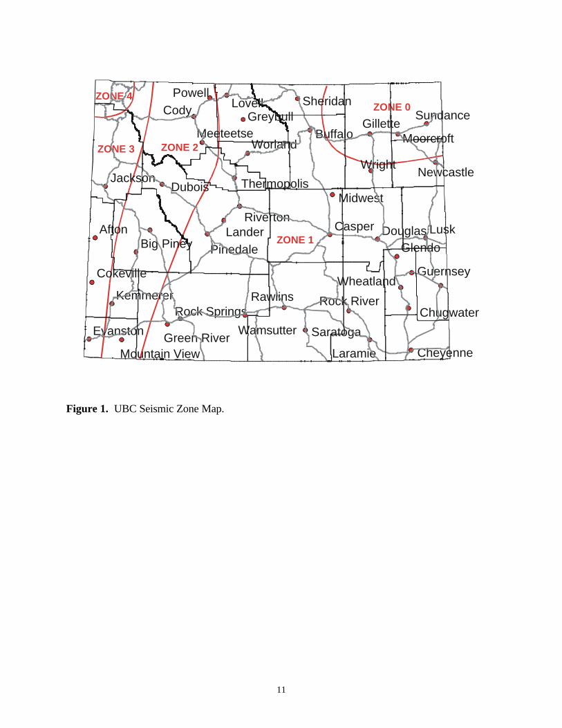
11
ZONE 0
ZONE 1
ZONE 2ZONE 3
ZONE 4
Lusk
Cody
Afton
Wright
PowellLovell
LanderGlendo
Dubois
Casper
Worland
Rawlins
Midwest
Laramie
Jackson
Douglas
Buffalo
SundanceSheridan
Saratoga
Riverton
Pinedale
Kemmerer
Guernsey
Greybull Gillette
Evanston
Cheyenne
Wheatland
Wamsutter
Newcastle
MoorcroftMeeteetse
Cokeville
Chugwater
Big Piney
Rock River
Thermopolis
Green River
Rock Springs
Mountain View Figure 1. UBC Seismic Zone Map.
12
Zone Effective Peak Acceleration, % gravity (g) 4 30% and greater 3 20% to less than 30% 2 10% to less than 20% 1 5% to less than 10%
0 less than 5% The committee assumed that there was a 90% probability that the above values would not be exceeded in 50 years, or a 100% probability that the values would be exceeded in 475 to 500 years. Lincoln County is primarily in Seismic Zones 2 and 3 of the UBC. Since effective peak accelerations (90% chance of non-exceedance in 50 years) can range from 10%g-30%g in these two zones, and there has been some significant historic seismicity in the county, it may be reasonable to assume that a maximum peak acceleration of 30%g could be applied to the design of a non-critical facility located in the county if only the UBC were used. Such acceleration, however, is significantly less than would be suggested through newer building codes. Recently, the UBC has been replaced by the International Building Code (IBC). The IBC is based upon probabilistic analyses, which are described in a following section. Lincoln County still uses the UBC, however, as do most Wyoming counties as of November 2002.
Deterministic Analysis of Regional Active Faults with a Surficial Expression
Three active fault systems are present in Lincoln County. The Rock Creek fault system is a north-south-trending normal fault located approximately 15 miles west of Kemmerer, Wyoming, near Fossil Butte National Monument. McCalpin and Warren (1992) found evidence of late-Quaternary movement on this system. Based upon a surface rupture length of 24 miles (38 km) and Quaternary displacement amounts, it has been estimated that the Rock Creek fault is capable of generating a magnitude 6.9 to 7.2 earthquake with an approximate recurrence interval of 600-1500 years (Chambers, 1988; McCalpin, 1993). The most recent events on the Rock Creek fault, however, occurred approximately 3600±300 and 4600±200 years before present (McCalpin, 1993). This suggests that the recurrence interval for this fault system may be variable and an exact interval may be difficult to determine. A maximum magnitude 7.2 earthquake could generate peak horizontal accelerations of approximately 6.3%g at Afton, approximately 2.5%g at Alpine, approximately 29%g at Cokeville, approximately 18%g at Kemmerer and Diamondville, approximately 27%g at Lake Viva Naughton and Kemmerer City Reservoir, approximately 7.2%g at La Barge, approximately 9.1%g at Opal, and approximately 3.9%g at Thayne (Campbell, 1987). These accelerations are roughly equivalent to intensity VII earthquakes at Cokeville, Kemmerer, Diamondville, Lake Viva Naughton and Kemmerer City Reservoir; intensity V earthquakes at Afton, La Barge, Opal, and Thayne; and an intensity IV earthquake at Alpine. Moderate damage could occur at Cokeville, Kemmerer, Diamondville, Lake Viva Naughton, and Kemmerer City Reservoir, whereas Afton, La Barge, Opal, and Thayne could sustain light damage. No damage should occur at Alpine.
13
The second active fault system in Lincoln County is the Grey’s River fault system, located on the western side of the Wyoming Range. Evidence of late-Holocene movement has also been identified on this north-south-trending normal fault (Jones and McCalpin, 1992; McCalpin, 1993). Based upon an estimated surface rupture length of 54 km, the Grey’s River fault system could potentially generate a magnitude 7.1 earthquake with a recurrence interval of approximately 2970 – 3400 years (Jones, 1995; Jones and McCalpin, 1992). The most recent events on the fault occurred 1910-2110 and 5080-5310 years before present. However, because no movement occurred on the Grey’s River fault system between approximately 5000 and 15,000 years before present, this recurrence interval may be variable (Jones and McCalpin, 1992). A magnitude 7.1 earthquake could generate peak horizontal accelerations of approximately 17%g at Afton, approximately 11%g at Alpine, approximately 5.8%g at Cokeville, approximately 3.2%g at Kemmerer and Diamondville, approximately 7%g at La Barge, approximately 2.9%g at Opal, and approximately 14%g at Thayne (Campbell, 1987). These accelerations are roughly equivalent to intensity VI earthquakes at Afton, Alpine, and Thayne, intensity V earthquakes at Cokeville and La Barge, and intensity IV earthquakes at Kemmerer, Diamondville, and Opal. Light damage could occur in Afton, Alpine, and Thayne. Cokeville and La Barge could sustain very light damage. No damage should occur at Kemmerer, Diamondville, and Opal. The Star Valley fault system is the third active fault system in Lincoln County. This fault system, which has been subdivided into north and south segments, bounds the eastern edge of the Star Valley. Investigations of the Star Valley fault system determined that Holocene and late-Pleistocene offsets exist along the south fault segment (Piety et al., 1986; McCalpin et al., 1990; McCalpin, 1990). Several maximum magnitude earthquakes have been suggested for the Star Valley fault system. Piety and others (1986) proposed that the Star Valley fault system is capable of generating a maxiumum credible earthquake of magnitude 7.5 with a recurrence interval of 5,000 to 7,000 years. Based upon a surface rupture length of 27 miles, McCalpin and others (1990) determined that the Star Valley fault system could produce a maximum magnitude 7.2 earthquake. When McCalpin (1990) trenched a portion of the Star Valley fault near Afton, he determined that a magnitude 7.3 earthquake with a recurrence interval of 2550-6000 years is possible on this system. Approximately 5,500 years (radiocarbon age) has elapsed since the latest event on the fault system at the Afton locality. Based upon this evidence, the Star Valley fault system is near the maximum limit for the recurrence interval assigned to the system. Because of the extensive seismic activity associated with the area surrounding the Star Valley fault, and because of the close proximity of towns to this fault system, a maximum magnitude of 7.5 will be used for this analysis. It should also be noted that it has been approximately 5500 years since the last confirmed event on the Star Valley fault at Afton. This fault system is therefore nearing its recurrence interval limit. A magnitude 7.5 earthquake could generate peak horizontal accelerations of greater than 80%g at Afton, approximately 79%g at Alpine, approximately 6.6%g at Cokeville, approximately 3.2%g at Kemmerer and Diamondville, approximately 5.2%g at La Barge, approximately 2.9%g at Opal, and approximately 47%g at Thayne (Campbell, 1987). These accelerations are roughly equivalent to intensity IX earthquakes at Afton and Alpine, an intensity VIII earthquake at Thayne, intensity V earthquakes at Cokeville and La Barge, and intensity IV earthquakes at Kemmerer, Diamondville, and Opal. Afton and Alpine could sustain heavy damage. Moderate to heavy damage could occur at Thayne. Light damage could occur at Cokeville and La Barge, but Kemmerer, Diamondville, and Opal should sustain no damage.
14
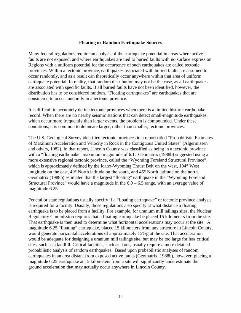
Floating or Random Earthquake Sources Many federal regulations require an analysis of the earthquake potential in areas where active faults are not exposed, and where earthquakes are tied to buried faults with no surface expression. Regions with a uniform potential for the occurrence of such earthquakes are called tectonic provinces. Within a tectonic province, earthquakes associated with buried faults are assumed to occur randomly, and as a result can theoretically occur anywhere within that area of uniform earthquake potential. In reality, that random distribution may not be the case, as all earthquakes are associated with specific faults. If all buried faults have not been identified, however, the distribution has to be considered random. “Floating earthquakes” are earthquakes that are considered to occur randomly in a tectonic province. It is difficult to accurately define tectonic provinces when there is a limited historic earthquake record. When there are no nearby seismic stations that can detect small-magnitude earthquakes, which occur more frequently than larger events, the problem is compounded. Under these conditions, it is common to delineate larger, rather than smaller, tectonic provinces. The U.S. Geological Survey identified tectonic provinces in a report titled “Probabilistic Estimates of Maximum Acceleration and Velocity in Rock in the Contiguous United States” (Algermissen and others, 1982). In that report, Lincoln County was classified as being in a tectonic province with a “floating earthquake” maximum magnitude of 6.1. Geomatrix (1988b) suggested using a more extensive regional tectonic province, called the “Wyoming Foreland Structural Province”, which is approximately defined by the Idaho-Wyoming Thrust Belt on the west, 104° West longitude on the east, 40° North latitude on the south, and 45° North latitude on the north. Geomatrix (1988b) estimated that the largest “floating” earthquake in the “Wyoming Foreland Structural Province” would have a magnitude in the 6.0 – 6.5 range, with an average value of magnitude 6.25. Federal or state regulations usually specify if a “floating earthquake” or tectonic province analysis is required for a facility. Usually, those regulations also specify at what distance a floating earthquake is to be placed from a facility. For example, for uranium mill tailings sites, the Nuclear Regulatory Commission requires that a floating earthquake be placed 15 kilometers from the site. That earthquake is then used to determine what horizontal accelerations may occur at the site. A magnitude 6.25 “floating” earthquake, placed 15 kilometers from any structure in Lincoln County, would generate horizontal accelerations of approximately 15%g at the site. That acceleration would be adequate for designing a uranium mill tailings site, but may be too large for less critical sites, such as a landfill. Critical facilities, such as dams, usually require a more detailed probabilistic analysis of random earthquakes. Based upon probabilistic analyses of random earthquakes in an area distant from exposed active faults (Geomatrix, 1988b), however, placing a magnitude 6.25 earthquake at 15 kilometers from a site will significantly underestimate the ground acceleration that may actually occur anywhere in Lincoln County.
15
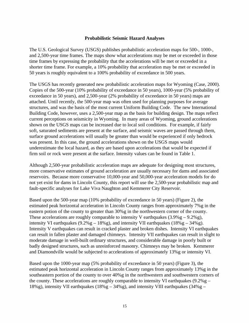
Probabilistic Seismic Hazard Analyses
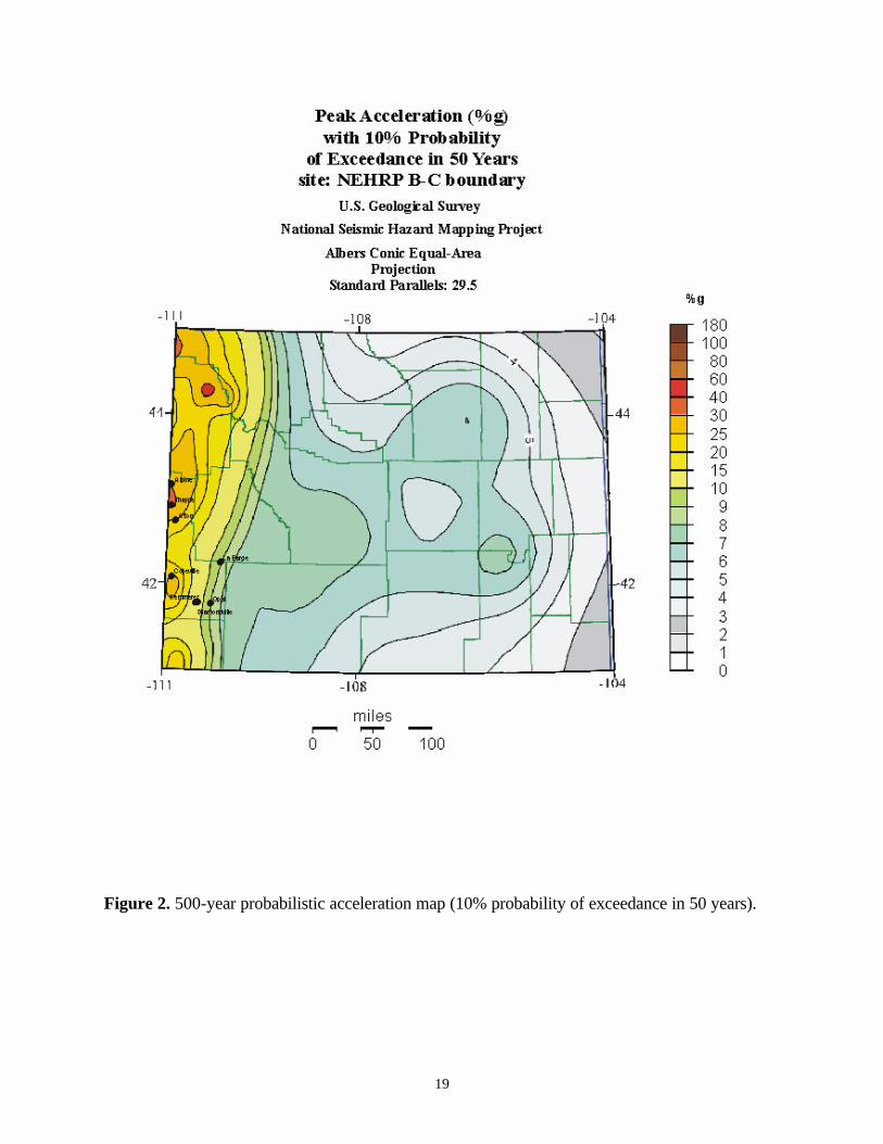
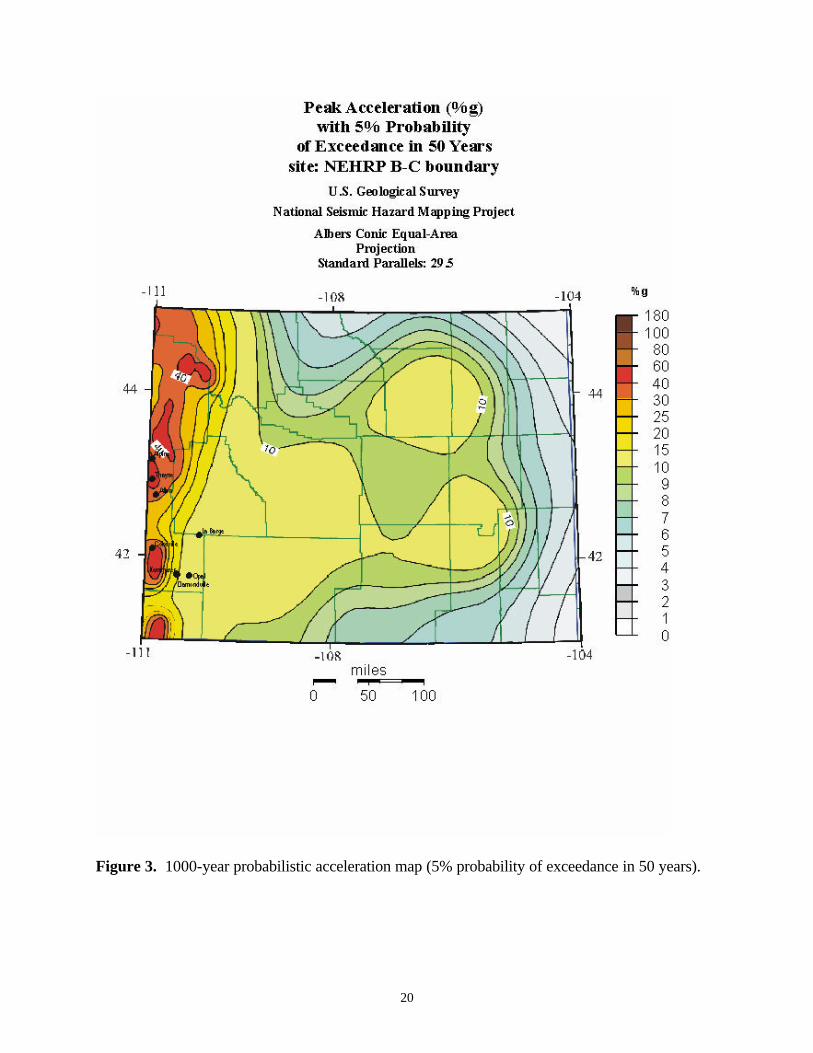
The U.S. Geological Survey (USGS) publishes probabilistic acceleration maps for 500-, 1000-, and 2,500-year time frames. The maps show what accelerations may be met or exceeded in those time frames by expressing the probability that the accelerations will be met or exceeded in a shorter time frame. For example, a 10% probability that acceleration may be met or exceeded in 50 years is roughly equivalent to a 100% probability of exceedance in 500 years. The USGS has recently generated new probabilistic acceleration maps for Wyoming (Case, 2000). Copies of the 500-year (10% probability of exceedance in 50 years), 1000-year (5% probability of exceedance in 50 years), and 2,500-year (2% probability of exceedance in 50 years) maps are attached. Until recently, the 500-year map was often used for planning purposes for average structures, and was the basis of the most current Uniform Building Code. The new International Building Code, however, uses a 2,500-year map as the basis for building design. The maps reflect current perceptions on seismicity in Wyoming. In many areas of Wyoming, ground accelerations shown on the USGS maps can be increased due to local soil conditions. For example, if fairly soft, saturated sediments are present at the surface, and seismic waves are passed through them, surface ground accelerations will usually be greater than would be experienced if only bedrock was present. In this case, the ground accelerations shown on the USGS maps would underestimate the local hazard, as they are based upon accelerations that would be expected if firm soil or rock were present at the surface. Intensity values can be found in Table 1. Although 2,500-year probabilistic acceleration maps are adequate for designing most structures, more conservative estimates of ground acceleration are usually necessary for dams and associated reservoirs. Because more conservative 10,000-year and 50,000-year acceleration models for do not yet exist for dams in Lincoln County, this report will use the 2,500-year probabilistic map and fault-specific analyses for Lake Viva Naughton and Kemmerer City Reservoir. Based upon the 500-year map (10% probability of exceedance in 50 years) (Figure 2), the estimated peak horizontal acceleration in Lincoln County ranges from approximately 7%g in the eastern potion of the county to greater than 30%g in the northwestern corner of the county. These accelerations are roughly comparable to intensity V earthquakes (3.9%g – 9.2%g), intensity VI earthquakes (9.2%g – 18%g), and intensity VII earthquakes (18%g – 34%g). Intensity V earthquakes can result in cracked plaster and broken dishes. Intensity VI earthquakes can result in fallen plaster and damaged chimneys. Intensity VII earthquakes can result in slight to moderate damage in well-built ordinary structures, and considerable damage in poorly built or badly designed structures, such as unreinforced masonry. Chimneys may be broken. Kemmerer and Diamondville would be subjected to accelerations of approximately 13%g or intensity VI. Based upon the 1000-year map (5% probability of exceedance in 50 years) (Figure 3), the estimated peak horizontal acceleration in Lincoln County ranges from approximately 13%g in the southeastern portion of the county to over 40%g in the northwestern and southwestern corners of the county. These accelerations are roughly comparable to intensity VI earthquakes (9.2%g – 18%g), intensity VII earthquakes (18%g – 34%g), and intensity VIII earthquakes (34%g –
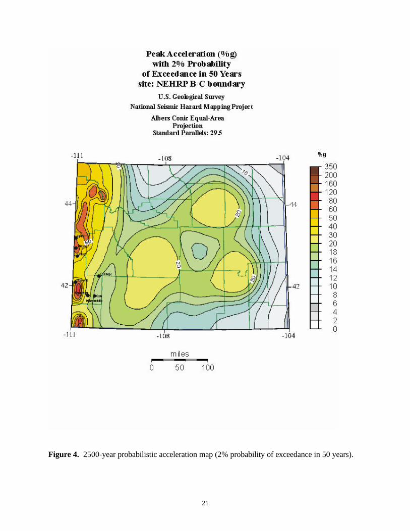
16
65%g). Intensity VI earthquakes can result in fallen plaster and damaged chimneys. Intensity VII earthquakes can result in slight to moderate damage in well-built ordinary structures, and considerable damage in poorly built or badly designed structures, such as unreinforced masonry. Chimneys may be broken. Intensity VIII earthquakes can result in considerable damage in ordinary buildings and great damage in poorly built structures. Panel walls may be thrown out of frames. Chimneys, walls, columns, factory stacks may fall. Heavy furniture may be overturned. Kemmerer and Diamondville would be subjected to accelerations of approximately 15-20%g or intensity VI-VII. Based upon the 2500-year map (2% probability of exceedance in 50 years) (Figure 4), the estimated peak horizontal acceleration in Lincoln County ranges from approximately 17%g in the southeastern corner of the county to over 60%g in the northern part of the county and over 80%g in the northwestern corner of the county. These accelerations are roughly comparable to intensity VI earthquakes (9.2%g – 18%g), intensity VII earthquakes (18%g – 34%g), intensity VIII earthquakes (34%g – 65%g), and intensity IX earthquakes (65%g-124%g). Intensity VI earthquakes can result in fallen plaster and damaged chimneys. Intensity VII earthquakes can result in slight to moderate damage in well-built ordinary structures, and considerable damage in poorly built or badly designed structures, such as unreinforced masonry. Chimneys may be broken. Intensity VIII earthquakes can result in considerable damage in ordinary buildings and great damage in poorly built structures. Panel walls may be thrown out of frames. Chimneys, walls, columns, factory stacks may fall. Heavy furniture may be overturned. Intensity IX earthquakes can cause considerable damage in specially designed structures and great damage and partial collapse in substantial buildings. Well-designed frame structures could be thrown out of plumb. Buildings can be shifted off their foundations. The ground can crack and underground pipes could be broken. Kemmerer and Diamondville would be subjected to accelerations of approximately 20-30%g, or intensity VII. Lake Viva Naughton and Kemmerer City Reservoir would be subjected to accelerations of approximately 40%g or intensity VIII earthquakes. Cokeville and Afton would be subjected to accelerations of approximately 60%g and 50%g, respectively, or intensity VIII. Thayne and Alpine would be subjected to accelerations greater than 60%g, or intensity IX. As the historic record is limited, it is nearly impossible to determine when a 2,500-year event last occurred in the county. Because of the uncertainty involved, and based upon the fact that the new International Building Code utilizes 2,500-year events for building design, it is suggested that the 2,500-year probabilistic maps be used for Lincoln County analyses. This conservative approach is in the interest of public safety.
17
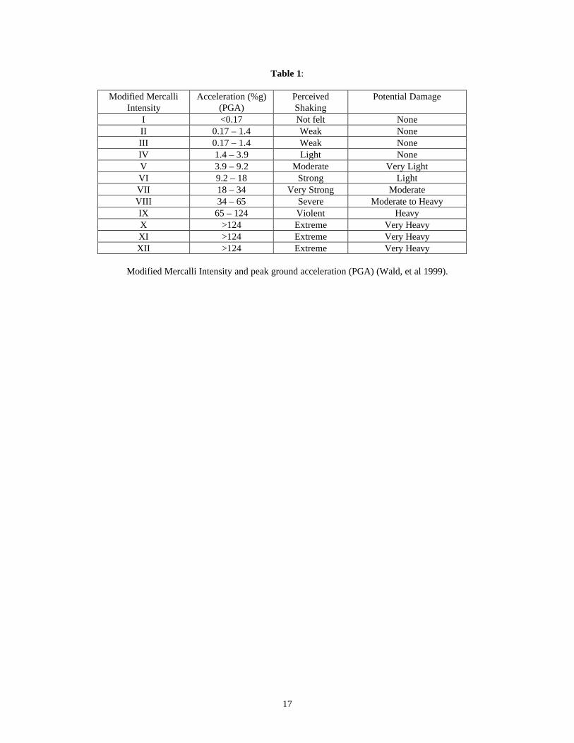
Table 1:
Modified Mercalli Intensity
Acceleration (%g) (PGA)
Perceived Shaking
Potential Damage
I <0.17 Not felt None II 0.17 – 1.4 Weak None III 0.17 – 1.4 Weak None IV 1.4 – 3.9 Light None V 3.9 – 9.2 Moderate Very Light VI 9.2 – 18 Strong Light VII 18 – 34 Very Strong Moderate VIII 34 – 65 Severe Moderate to Heavy IX 65 – 124 Violent Heavy X >124 Extreme Very Heavy XI >124 Extreme Very Heavy XII >124 Extreme Very Heavy
Modified Mercalli Intensity and peak ground acceleration (PGA) (Wald, et al 1999).
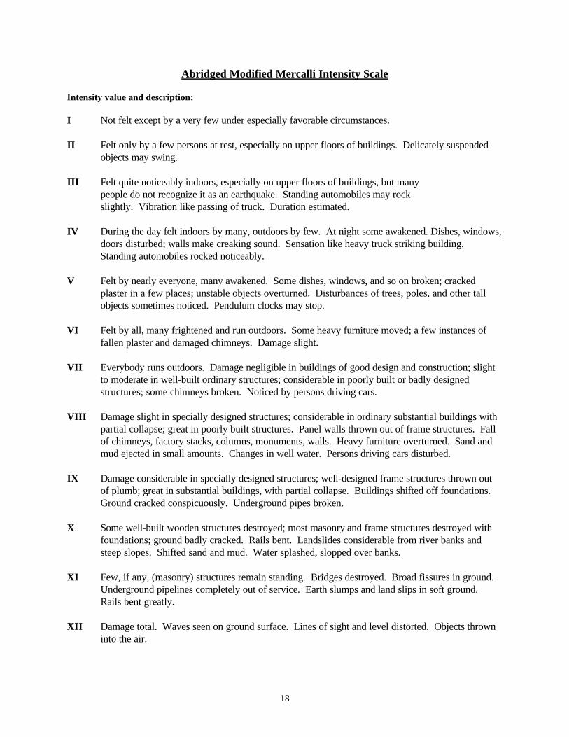
18
Abridged Modified Mercalli Intensity Scale Intensity value and description: I Not felt except by a very few under especially favorable circumstances. II Felt only by a few persons at rest, especially on upper floors of buildings. Delicately suspended
objects may swing. III Felt quite noticeably indoors, especially on upper floors of buildings, but many people do not recognize it as an earthquake. Standing automobiles may rock slightly. Vibration like passing of truck. Duration estimated. IV During the day felt indoors by many, outdoors by few. At night some awakened. Dishes, windows,
doors disturbed; walls make creaking sound. Sensation like heavy truck striking building. Standing automobiles rocked noticeably.
V Felt by nearly everyone, many awakened. Some dishes, windows, and so on broken; cracked
plaster in a few places; unstable objects overturned. Disturbances of trees, poles, and other tall objects sometimes noticed. Pendulum clocks may stop.
VI Felt by all, many frightened and run outdoors. Some heavy furniture moved; a few instances of
fallen plaster and damaged chimneys. Damage slight. VII Everybody runs outdoors. Damage negligible in buildings of good design and construction; slight
to moderate in well-built ordinary structures; considerable in poorly built or badly designed structures; some chimneys broken. Noticed by persons driving cars.
VIII Damage slight in specially designed structures; considerable in ordinary substantial buildings with
partial collapse; great in poorly built structures. Panel walls thrown out of frame structures. Fall of chimneys, factory stacks, columns, monuments, walls. Heavy furniture overturned. Sand and mud ejected in small amounts. Changes in well water. Persons driving cars disturbed.
IX Damage considerable in specially designed structures; well-designed frame structures thrown out
of plumb; great in substantial buildings, with partial collapse. Buildings shifted off foundations. Ground cracked conspicuously. Underground pipes broken.
X Some well-built wooden structures destroyed; most masonry and frame structures destroyed with
foundations; ground badly cracked. Rails bent. Landslides considerable from river banks and steep slopes. Shifted sand and mud. Water splashed, slopped over banks.
XI Few, if any, (masonry) structures remain standing. Bridges destroyed. Broad fissures in ground.
Underground pipelines completely out of service. Earth slumps and land slips in soft ground. Rails bent greatly.
XII Damage total. Waves seen on ground surface. Lines of sight and level distorted. Objects thrown
into the air.
19
Figure 2. 500-year probabilistic acceleration map (10% probability of exceedance in 50 years).
20
Figure 3. 1000-year probabilistic acceleration map (5% probability of exceedance in 50 years).
21
Figure 4. 2500-year probabilistic acceleration map (2% probability of exceedance in 50 years).
22
Summary There have been thousands of historic earthquakes with a magnitude greater than 2.0 recorded in and near Lincoln County. Because of the limited historic record, it is possible to underestimate the seismic hazard in Lincoln County if historic earthquakes are used as the sole basis for analysis. Earthquake and ground motion probability maps and specific fault analyses give a more reasonable estimate of damage potential in Lincoln County. Current earthquake probability maps that are used in the newest building codes suggest a scenario that would result in moderate to heavy damage to buildings and their contents, with damage increasing from the southeast to the north and southwest. More specifically, the probability-based or fault activation-based worst-case scenario could result in the following damage at points throughout the county: Intensity IX Earthquake Areas Afton Alpine Auburn Bedford Fossil Butte National Monument Grover Thayne Turnerville Intensity IX earthquakes can cause considerable damage in specially designed structures and great damage and partial collapse in substantial buildings. Well-designed frame structures could be thrown out of plumb. Buildings can be shifted off their foundations. The ground can crack and underground pipes could be broken. Intensity VIII Earthquake Areas Auburn Border Cokeville Fairview Kemmerer City Reservoir Lake Viva Naughton Sage Smoot Intensity VIII earthquakes can result in considerable damage in ordinary buildings and great damage in poorly built structures. Panel walls may be thrown out of frames. Chimneys, walls, columns, factory stacks may fall. Heavy furniture may be overturned.

23
Intensity VII Earthquake Areas Elkol Frontier Diamondville Kemmerer La Barge Opal In intensity VII earthquakes, damage is negligible in buildings of good design and construction, slight-to-moderate in well-built ordinary structures, considerable in poorly built or badly designed structures such as unreinforced masonry buildings. Some chimneys will be broken.
24
References
Algermissen, S.T., Perkins, D.M., Thenhaus, P.C., Hanson, S.L., and Bender, B.L., 1982, Probabilistic estimates of maximum acceleration and velocity in rock in the contiguous United States: U.S. Geological Survey Open File Report 82-1033, 99 p., scale 1:7,500,000. Bodle, R.R., 1946, United States earthquakes 1944: U.S. Coast and Geodetic Survey, Serial No. 682, 43 p. Brazee, R.J., and Cloud, W.K., 1959, United States earthquakes 1957: U.S. Department of Commerce, Coast and Geodetic Survey, 108 p. Brazee, R.J., and Cloud, W.K., 1960, United States earthquakes 1958: U.S. Department of Commerce, Coast and Geodetic Survey, 76 p. Campbell, K.W., 1987, Predicting strong ground motion in Utah, in Gori, P.L., and Hays, W.W., editors, Assessment of regional earthquake hazards and risk along the Wasatch front, Utah, Volume 2: U.S. Geological Survey Open File Report 87-585, pp. L1-90. Case, J.C., 2000, Earthquakes in Wyoming: Wyoming State Geological Survey, Wyoming Geo-notes No. 66, pp. 49-56. Case, J.C., 2000, Probability of damaging earthquakes in Wyoming: Wyoming State Geological Survey, Wyoming Geo-notes No. 67, pp. 50-55. Case, J.C., 1997, Earthquakes and active faults in Wyoming: Wyoming State Geological Survey Preliminary Hazards Report 97-2, 58 p. Case, J.C., 1997, Historical seismicity of south-central and southeastern Wyoming: Wyoming State Geological Survey Wyoming Geo-notes Number 56, pp. 54-59. Case, J.C., 1997, Overview of historical seismicity in western Wyoming, Part 2: Wyoming State Geological Survey Geo-notes Number 55, pp. 43-52. Case, J.C., Larsen L.L., Boyd, C.S., and Cannia, J.C., 1997, Earthquake epicenters and suspected active faults with surficial expression in Wyoming: Wyoming State Geological Survey Geologic Hazards Section Preliminary Hazards Report 97-1, scale 1:1,000,000. Case, J.C., 1996, Historical seismicity of northeastern and east-central Wyoming: Wyoming State Geological Survey Wyoming Geo-notes Number 51, pp. 50-55. Case, J.C., 1996, Historical seismicity in Southwestern Wyoming: Wyoming State Geological Survey Wyoming Geo-notes Number 50, pp. 52-56.
25
Case, J.C., 1993, Geologic Hazards in Wyoming: Wyoming State Geological Survey Wyoming Geo-notes Number 40, pp. 46-48. Chambers, H.P., 1988, A regional ground motion model for historical seismicity along the Rock Creek fault, western Wyoming: unpublished M.S. thesis, University of Wyoming, Laramie, 95 p. Coffman J.L., von Hake, C.A., Spence, W., Carver, D.L., Covington, P.A., Dunphy, G.J., Irby, W.L., Person, W.J., and Stover, C.W., 1975, United Staes Earthquakes 1973: U.S. National Oceanic and Atmospheric Administration and U.S. Geological Survey, 112 p. Geomatrix Consultants, Inc., 1988a, Seismotectonic evaluation of the northwestern Wind River Basin: Report prepared for the U.S. Bureau of Reclamation, Contract No. 6-CS-81-07310, 116 p. Geomatrix Consultants, Inc., 1988b, Seismotectonic evaluation of the Wyoming Basin geomorphic province: Report prepared for the U.S. Bureau of Reclamation, Contract No. 6-CS-81-07310, 167 p. Gibbons, A.B., and Dickey, D.D., 1983, Seismotectonic study, Jackson Lake dam and reservoir, Minidoka project, Wyoming: U.S. Bureau of Reclamation Seismotectonic Report 83-8, 123 p. Humphreys, W.J., 1915, Seismological reports for March, 1915, in Abbe, C., editor, monthly weather review: U.S. Department of Agriculture, Weather Bureau Monthly Weather Review, v. 43, no. 3, p. 142-145. Humphreys, W.J., 1921, Seismological reports for October 1914 to June 1924: U.S. Weather Bureau, Monthly Weather Review, Section V-Seismology. Jones, L.A.C., 1995, The Quaternary Geology of the Eastern Side of the Grey’s River Valley and the Neotectonics of the Grey’s River Fault in Western Wyoming: unpublished M.S. thesis, Utah State University, Logan, 116 p. Jones, L.C.A., and McCalpin, J.P., 1992, Quaternary faulting on the Grey’s River fault, a listric normal fault in the overthrust belt of Wyoming: Geological Society of America Abstracts with Programs, v.24, no.6, p.20. McCalpin, J.P., 1993, Neotectonics of the northeastern Basin and Range margin, western USA: Zeitschrift fuer Geomorphologie N. Folge, v.94, p.137-157. McCalpin, J.P., and Warren, G. A., 1992, Quaternary faulting on the Rock Creek fault, overthrust belt, Wyoming: Geological Society of America Abstracts with Programs, v.24, no.6, p.51. McCalpin, J.P., 1990, Latest Quaternary faulting in the northern Wasatch to Teton corridor (NWTC): Final Technical Report prepared by Department of Geology, Utah State University, Logan, UT, for the U.S. Geological Survey, 42 p.
26
McCalpin, J.P., Piety, L.A., and Anders, M.H., 1990, Latest Quaternary faulting and structural evolution of Star Valley, Wyoming in Roberts, Sheila, editor, Geologic field tours of western Wyoming and parts of adjacent Idaho, Montana, and Utah: Geological Survey of Wyoming Public Information Circular No. 29, p. 5-12. McGrew, L.W., 1961, Structure of Cenozoic rocks along the northwestern margin of the Julesburg Basin, southeastern Wyoming (abstract): Geological Society of America, Rocky Mountain Section, Annual Meeting Program, Laramie, Wyoming, May 11-13, 1961, p. 22. Murphy, L.M., and Ulrich, F.P., 1952, United States earthquakes 1950: U.S. Coast and Geodetic Survey, Serial No. 755, 47 p. Murphy, L.M., and Cloud, W.K., 1954, United States earthquakes 1952: U.S. Department of Commerce, Coast and Geodetic Survey, Serial No. 773, 112p. Neumann, F., and Bodle, R.R., 1932, United States earthquakes 1930: U.S. Department of Commerce, Coast and Geodetic Survey Serial No. 539, 25 p. Neumann, F., 1927, Seismological report, October, November, December, 1925, and supplement for 1924: Department of Commerce, U.S. Coast and Geodetic Survey Serial No. 388, 120 p. Piety, L.A., Wood, C.K., Gilbert, J.D., Sullivan, J.T., and Anders, M.H., 1986, Seismotectonic study for Palisades Dam and Reservoir, Palisades project: U.S. Bureau of Reclamation Seismotectonic Report 86-3, 198 p. Reagor, B.G., Stover, C.W., and Algermissen, S.T., 1985, Seismicity map of the State of Wyoming: U.S. Geological Survey Miscellaneous Field Studies Map MF-1709, scale 1:1,000,000. Stover, C.W., 1985, Preliminary isoseismal map and intensity distribution for the Laramie Mountains, Wyoming, earthquake of October 18, 1984: U.S. Geological Survey Open File report 85-137, 9 p. U.S.G.S. National Earthquake Information Center: http://wwwneic.cr.usgs.gov/ University of Utah Seismograph Station Epicenter Listings: http://www.seis.utah.edu/HTML/EarthquakeCatalogAndInfo.html Wald D.J., Quitoriano V., Heaton T.H., Kanamori H., 1999, Relationships between Peak Ground Acceleration, Peak Ground Velocity and Modified Mercalli Intensity in California, Earthquake Spectra, v. 15, no. 3, 557-564. West, M.W., 1989, Neotectonics of the Darby-Hogsback and Absaroka thrust plates, Lincoln County, Wyoming and Summit County, Utah with applications to earthquake hazard assessment: Golden, Colorado School of Mines, unpublished Ph.D. dissertation, 450 p., 17 pls.

27
West, M.W., 1994, Seismotectonics of North-Central Utah and Southwestern Wyoming: Utah Geological Survey Special Study 82, Paleoseismology of Utah, v.4, 93 p. Wong, I., Dober, M., Fenton, C., 2001, Probabilistic Seismic Hazard Analyses Alcova, Glendo, Guernsey, Kortes, Pathfinder, and Seminoe Dams: Report prepared by URS Greiner Woodward Clyde for the U.S. Department of the Interior, Bureau of Reclamation, Denver, Colorado.