Embed Size (px)
Citation preview
1
Bayfield County Forest
Barrens Management Plan
Barnes Barrens Management Area (BBMA)
Preface
Pine barrens is a globally and regionally rare natural community that supports many endangered,
threatened, rare and declining native plants and animals. Pine barrens are classified as imperiled,
both globally (G2), as well as in the state of Wisconsin (S2). In addition, chapter 825.5 of the
Bayfield County Forest Comprehensive Land Use Plan (hereafter, Land Use Plan) identifies Pine
Barrens as a habitat of importance. The Land Use Plan also outlines general parameters
regarding pine barrens management and introduces the concepts of surrogate and floating
barrens. The Barnes Barrens Management Plan (hereafter, BBMA) is intended to provide
guidance and direction in the development and perpetual maintenance of large block pine barrens
habitat on the Bayfield County Forest.
Location and History
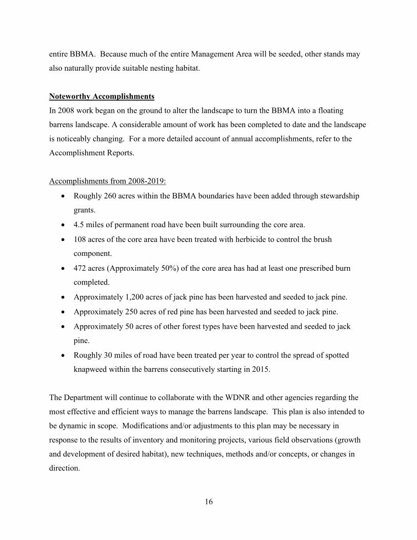
The BBMA is roughly 11,700 acres in size, is located in the Town of Barnes in western Bayfield
County and is within the Northwest Sand Ecological Landscape. This area is considered one of
Wisconsin’s Priority Conservation Opportunity Areas for Wildlife Species of Greatest
Conservation Need, referred to as the Douglas and Bayfield County Barrens Conservation
Opportunity Area. A complete description of the Northwest Sands Landscape is available in the
on the DNR Website (see the Appendix for a link to the Ecological Landscapes webpage).
Pine barrens are classified as a true savanna type. The term savanna is used for any plant
community where trees are a component, but where their density is low enough to support
grasses and other sun-loving herbaceous vegetation. Pine barrens are unique among savannas in
that the shrub component is much more extensive than in other savanna types.
According to some estimates, pine barrens once covered nearly 7% of the state of Wisconsin (or
nearly 2.4 million acres). But have since become increasingly rare. Many wildlife species, like
2
the once federally endangered Kirtland’s Warbler, and many species of flora and fauna are
dependent on the existence of pine barrens.
Three major factors: fire, soils, and topography dominate the development and maintenance of
Pine barrens. Humans have had a large influence on the fire factor. Intensive fire control has
virtually eliminated the frequent fires which once occurred naturally in the pine barrens.
Pine barrens are a tenuous group of communities pulled in opposing directions by disturbance
and plant succession. Depending on the severity and frequency of disturbance, or the lack
thereof, pine barrens communities range structurally from grasslands to forests. Pine barrens
habitat or community types include:
Open Barrens: This is a grassy, prairie-like habitat type with very little woody
vegetation. It is an early seral stage of pine barrens habitat. Over time and in the absence
of disturbance such as fire, woody vegetation will become increasingly abundant and
dominant, changing to a different habitat type.
Brush Prairie Barrens: This type is dominated by short woody vegetation, including
hazel, willow, scrub oak, and scrub aspen.
Savanna Barrens: This type contains scattered individual trees from small groups of trees
to patches or stands of trees. Tree age can vary from young to mature. Tree height can
range from short, i.e. scrubby, on low moisture, poor nutrient sites, to average height on
better sites. This type is often a transitional type or phase between the open or brush
prairie barren types and the forested barrens type.
Forested (Pine) Barrens: These are areas where trees have become dominant and are
generally considered to be a forest habitat type. These areas usually contain and retain all
of the plant species associated with the more open barren habitat types. When a
disturbance, such as a fire or timber sale occurs in this type, these sun loving plant
3
species will become more abundant and dominant until trees begin to crowd and shade
them out.
In the absence of fire, natural plant succession coupled with an intensive tree planting program
has turned almost all of the pine barrens in Bayfield County and in Wisconsin into forests. Pine
barrens management on the Bayfield County Forest includes the creation and maintenance of
both permanent and temporary (surrogate) open barrens and brush prairie barrens habitat types.
These are the least common types of pine barrens habitat and are the types that, in the absence of
disturbance, become forested over time; hence they become a forest habitat.
The following sections outline the critical steps required to create and maintain permanent and
surrogate barrens within the BBMA. The strategic use of commercial timber sales, prescribed
fire and herbicide application will be implemented to achieve this goal.
Goals and Objectives
This special management area will provide critically important pine barrens habitat through the
simultaneous development of jack pine and open and early successional barrens. In managing
any natural resource, it is necessary to develop principles and guidelines to meet specific
objectives. This plan defines operational parameters and guidelines that should be followed to
achieve the desired future condition. Management Zones were designed to give the forester
flexibility in timber sale planning. A few important objectives are as follows:
1. Delineate approximately 11,700 acres as a special management area on the Bayfield
County Forest for the simultaneous management of timber products and the development
and maintenance of early successional open and brush prairie pine barrens habitat.
2. Identify and delineate a “core” area and four management zones within the special
management area. The core area will provide permanent open barrens habitat and the
zones will serve as floating surrogate barrens.

4
3. Develop a timetable for the systematic harvest and regeneration of timber in each
designated management zone.
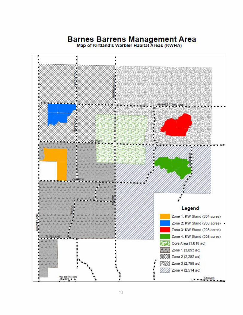
4. Designate approximately 200 contiguous acres within each zone as Kirtland’s Warbler
Habitat Areas (KWHA). Reforest these areas to jack pine at densities that are conducive
to creating suitable Kirtland’s Warbler habitat. Currently, suitable habitat contains at
least 1,200 stems per acre, combined with 1 to 5 unforested openings per acre. Openings
should total approximately 25% of the stand and be evenly distributed.
5. Direct the Foresters of Bayfield County, through principles and guidelines, in the
sustainable management of the BBMA.
Principles and Guidelines
When implementing the management plan, whenever possible, incorporate the following
principles and guidelines. Stand conditions and updated reconnaissance may influence future
planning and goals:
1. Harvest all merchantable jack pine within the BBMA by year 2025, as outlined in the
attached map “Barnes Barrens cutting cycle 2020 to 2035”. Excessive mortality within
individual stands may require accelerated harvests.
2. Within each zone, plan and establish timber harvests in a manner that that does not
impede, obstruct or otherwise diminish the intended purpose of the surrogate barrens or
functional connectivity to the permanent core area.
3. The roughly 1,000 acre core area will be maintained using prescribed fire and/or
mechanical/chemical vegetative treatments to ensure the persistence of native warm
season grasses and forbs.
4. Prescribed fire has proven to be the most effective tool in maintaining grass and forb
dominated habitats and is the preferred method of maintenance. However, herbicide has
5
shown to be a useful tool in establishing open prairie barrens habitat by effectively
controlling the woody competition. One application of herbicide can be as, if not more,
effective than repeated prescribed burning in the creation of open prairie barrens habitat.
5. Fire management zones (fuel break roads) will be established on the perimeter of the
Core Area and maintained to the same standards as County Forest Primary Roads. All
roads will have a 50 foot wide defensible zone maintained on both sides of the road.
These roads will help facilitate timely prescribed burns and reduce the need to construct
new fuel breaks every time a prescribed burn is conducted.
6. Most red pine within the planning area will be converted to jack pine by 2082, whenever
possible. However, all existing red pine stands will be managed (thinned) as scheduled
until the point of conversion to jack pine.
7. Throughout this process, some red pine stands may be retained and/or planted to enhance
the barrens habitat. A total of up to approximately 1,000 acres of red pine (or roughly
10% of the BBMA) may be maintained to increase diversity. Whenever possible, the
location of these stands will be adjacent to the exterior boundary of the BBMA or
positioned in a way to minimize any potential connectivity issues and/or conflicts with
the core area. Also whenever possible, the total amount of red pine acreage should be
equally distributed within each Zone (i.e. so that red pine comprises no more than 10% of
the total acreage of each Zone).
8. If a stand is reforested to red pine, it will be managed as per standard county practices, as
addressed in the Land Use Plan, and rotated in compliance with the management
objectives for that Zone. An opportunity may exist to maximize the economic potential
of the stand by planting the first year when operating in the Zone and regenerating during
the last year of re-entry. In this scenario the stand of red pine will be around 60 years old
at the time of rotation and thinned about three times prior to the last harvest (providing a
better opportunity to develop a significant volume of poles). Further increasing the total
acreage of red pine may be considered in each Zone, assuming potential negative impacts
6
to the quality of barrens habitat and/or connectivity to the core area are
negligible/minimal. If considering increasing the percentage of red pine acreage within
each Zone, DNR wildlife biologists should be consulted to discuss potential impacts.
9. Scarification and seeding will be the preferred method of regenerating jack pine,
whenever feasible. Seeding creates a more variable and natural stand condition that has
shown to be preferable to species dependent on pine barrens habitat. Compared to
planting, overall volumes per acre tend to be slightly less, but establishment costs are
typically less than half.
a. On sites that are seeded, a seedling count is conducted generally three to four
years after the reforestation activity. It typically takes a few years for seedlings to
germinate and develop. One to two more regeneration surveys are usually
conducted before a seeded site is considered successful. If additional inputs are
required, they are addressed as soon as possible. A final seedling count is
typically conducted at year 10.
b. A seeded site is generally considered established when monitoring results indicate
at least 400 desirable tree seedlings per acre on at least 60% of the survey plots
(during the first seedling count). If the minimum stocking levels are not achieved,
the Department may prescribe supplemental planting or seeding and/or additional
site preparation or a combination thereof. Additional reforestation surveys may
also be required to monitor results.
c. All reforestation activities will be monitored according to protocols outlined in
the Land Use Plan or similar document adopted by the Department.
d. Deer browse has traditionally been a significant issue on all stands of jack pine
that are planted on the County Forest, especially when using containerized stock.
If planting jack pine, seedling protection (from deer browse) should also be
considered. Bud capping has been one of the most successful and cost effective
methods to minimize loss and/or plantation failure as a result of excessive deer
browse.
7
10. Incorporate cutting prescriptions that do not facilitate the spread of insect and disease.
For example, leaving residual trees within the surrogate barrens produces an increased
risk of jack pine budworm defoliation and spread of diplodia. Another consideration is to
design sale boundaries that result in the least amount of edge as possible (make sales as
blocky as possible). Irregular sale boundaries create environments favorable to the jack
pine budworm. Green tree retention, or other practices that retain reserve/leave trees, will
generally not be considered on all stands that are managed within the BBMA.
11. Aspen and scrub oak stands may be maintained within each Management Zone, but not
allowed to expand and compete with stands of jack pine. Conversion of some aspen or
scrub oak stands to jack pine is allowed only when strategically and economically
feasible. If oak wilt is found within 6 miles of any scrub oak stand within the BBMA, it
may be necessary to convert the stand to jack pine or red pine. Aspen has historically
been a component of pine barrens habitat. Some wildlife species that utilize this habitat
depend upon aspen as a food source. The most cost effective means of limiting the
natural conversion of jack pine stands to aspen is with the use of selective herbicides.
There are currently 646 acres of aspen and 175 acres of scrub oak within the BBMA.
12. Jack pine will be the primary forest type maintained within the BBMA. However,
roughly 15% (and no more than 20%) of the total area may be comprised of a
combination of red pine, aspen, and scrub oak types, to achieve a level of habitat
diversity within the BBMA. Whenever possible, an emphasis will be placed on evenly
distributing habitat diversity across all Zones, in locations that will not obstruct or
otherwise inhibit the connectivity to and/or natural functions of the core area.
13. Management Zones will be used to determine an average harvest schedule per year.
Prescribed activities for individual stands have a tendency to create an uneven schedule
of harvests per year. Management zones will provide an even distribution of harvests per
year and better facilitate responses to insect and disease outbreaks, wildfires, blow-
downs, and other unanticipated natural events.

8
14. Refer to the annual Workplan for a detail of management goals during the calendar year.
Also refer to the annual Accomplishment Report for a summary of completed work
within the BBMA.
15. Work closely with State wildlife personnel and other natural resource professionals in
coordinating management strategies within the BBMA. Management strategies are fairly
dynamic and often evolve based on a variety of factors, including, but not limited to: best
available science; lessons from past practices; responses to climate change; impacts of
insects, disease and/or wildfire; demonstrated wildlife habitat use patterns; social
pressures; etc. This plan outlines general goals and objectives for a large portion of the
County Forest over a very long period of time. As the process develops and new
information is realized, adjustments and/or modifications to the plan are to be expected.
a. Refer to the DNR Barrens Best Management Practices document for additional
guidance and considerations. The Barrens BMP document can be located in the
Appendix.
Implementation
The plan will be implemented in two different stages. The first stage is the management of
mature jack pine and the creation of the permanent “Core Area”. The second stage is the
development of the floating surrogate barrens within each Management Zone.
The boundaries of the Zones were established based on the existing age classes of jack pine and
should not be considered permanent. Ideally, each Zone would consist of an equal proportion of
acreage and contact with the Core Area. Future sale design and reforestation should strive
towards this goal. Stand conditions and improved reconnaissance may influence future planning
and goals within each Management Zone.
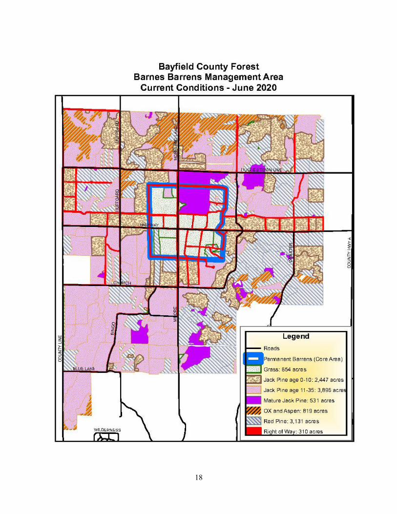
Stage 1 – Core Area, Mature Isolated Jack Pine Management, Existing Red Pine Management
Mature jack pine is currently scattered throughout the entire BBMA. All mature jack pine will
be regenerated within the area by the year 2025. Harvest goals for the mature jack pine will be
9
developed on an annual basis. Excessive mortality within the stands may trigger an acceleration
of harvest levels. Below is a summary of action items over the development period (refer to the
map “Floating Barrens Cutting Cycle 2020 to 2035” for more detail).
Action: In all Zones, manage (thin) all stands of red pine as scheduled until the point of
conversion to jack pine.
Action: In Zone 4, from approximately CY 2020 through year 2029, harvest stands of
red pine with origin year 1990 and older and convert to jack pine. Harvests will
average approximately 110 acres per year over the 10 year period.
Action: In Zone 4, from CY 2021 through approximately 2022 harvest two remaining
stands of mature jack pine (113 acres total). In addition, from CY 2021 through 2029
harvest all remaining mature jack pine, less than 10 acres in size, that are located
adjacent to other stands that are ready for management (30 acres total).
Action: Establish the Core Area by no later than 2035 (earlier if possible).
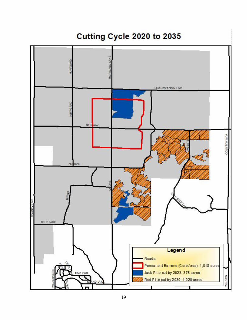
Stage 2 – Floating Surrogate Barrens Development
The approximately 11,700 acre BBMA is broken into four Management Zones. Each Zone
surrounds a roughly 1,000 acre, permanently open core area and ranges in size from 2,282 to
3,093 acres. The Management Zones are assigned a 12 year harvest interval (where each Zone is
completely harvested over a period of 12 years). During the harvest interval, whenever possible,
all stands within each Zone will be harvested and then seeded or planted primarily with jack
pine.
From the time of harvest until the point when the jack pine regeneration is approximately 10 feet
in height, stand characteristics will meet the criteria for Brush Prairie Barrens. Typically,
suitable Brush Prairie habitat will exist for 10 to 15 years after harvest. The habitat created
during this 10 to 15 year window will serve as temporary or “surrogate barrens”.
10
Within each designated Zone, stands will be harvested in an attempt to create a continuous 0 to
12 year old age class in relative contiguous contact with the Core Area at all times. This stage
will begin around 2035 or as soon as the jack pine is merchantable in Zone 1. Completion of this
stage (the management of the last stand in Zone 4) is expected to be by the year 2082 and
repeated indefinitely.
Also within each Zone, an attempt will be made to equally distribute regeneration acres over the
entire management period (basically, the acreage of the Zone divided by 12 years). Whenever
possible, an attempt will be made to arrange the establishment of timber sales near the Core Area
first, working toward the outer boundary of the Zone by the end of the harvest period
(maintaining visual connectivity with the Core Area is not critical, but will enhance the overall
suitability of the habitat).
Within the approximate center of each Zone, roughly 200 acres will be designated as a KWHA.
The Areas will be planted or seeded at higher densities than normal, but will ultimately be
managed like the rest of the stands (on approximately 48 year rotations).
Once fully regulated, stands within each Zone will be managed on a roughly 48 year rotation. It
may be necessary to manage individual stands slightly earlier or later (meaning some individual
stands may be a little younger or older than 48 years when harvested), but the overall goal is to
complete one floating surrogate barrens cycle every 48 years.
Below is a summary of action items over the initial development period (refer to the map
“Floating Barrens Cutting Cycle 2035 to 2082” for more detail).
Action: In Zone 1, from approximately 2035 through year 2046, harvest all stands
located within the Zone and, when possible, regenerate to jack pine. Harvests will
average approximately 250 acres per year over the 12 year period. Also, manage (thin)
red pine in other Zones as scheduled until the point of conversion to jack pine.
11
Action: In Zone 2, from approximately 2047 through year 2058, harvest all stands
located within the Zone and, when possible regenerate to jack pine. Harvests will
average approximately 154 acres per year over the 12 year period. Also, manage (thin)
red pine in other Zones as scheduled until the point of conversion to jack pine.
Action: In Zone 3, from approximately 2059 through year 2070, harvest all stands
located within the Zone and, when possible regenerate to jack pine. Harvests will
average approximately 203 acres per year over the 12 year period. Also, manage (thin)
red pine in other Zones as scheduled until the point of conversion to jack pine.
Action: In Zone 4, from approximately 2071 through year 2082, harvest all stands
located within the Zone and, when possible regenerate to jack pine. Harvests will
average approximately 191 acres per year over the 12 year period.
Summary of Action Items By Year
2020 – 2035: Establish the remaining portions of the Core Area. Also, manage (thin) all red
pine in Zones 1, 2 and 3 as scheduled until the point of conversion to jack pine.
2020 – 2029: In Zone 4, harvest all stands of red pine with an origin year of 1990 or older and
convert to jack pine. Harvests will average approximately 110 acres per year over
the 10 year period.
2020 – 2082: In all Zones, harvest all aspen and scrub oak as scheduled. Some aspen stands
may require a rotation age closer to 60 years and all scrub oak stands will be
harvested at a rotation age closer to 70 years.
2021 – 2029: Harvest all mature jack pine throughout Zone 4. From CY 2021 through
approximately 2022, harvest two remaining stands of mature jack pine (113 acres
total). In addition, from CY 2021 through 2029, harvest all remaining mature
jack pine, less than 10 acres in size, located adjacent to stands that are ready for
management (30 acres total). High levels of mortality may require an
12
acceleration of harvest schedules. Throughout the BBMA, stands of red pine will
be managed (thinned) as scheduled until the point of conversion to jack pine.
2035 – 2046: In Zone 1, harvest all stands located within the Zone and, when possible,
regenerate to jack pine. Harvests will average approximately 250 acres per year
over the 12 year period. Also, manage (thin) red pine in other Zones as scheduled
until the point of conversion to jack pine.
2047 – 2058: In Zone 2, harvest all stands located within the Zone and, when possible
regenerate to jack pine. Harvests will average approximately 154 acres per year
over the 12 year period. Also, manage (thin) red pine in other Zones as scheduled
until the point of conversion to jack pine.
2059 – 2070: In Zone 3, harvest all stands located within the Zone and, when possible
regenerate to jack pine. Harvests will average approximately 203 acres per year
over the 12 year period. Also, manage (thin) red pine in other Zones as scheduled
until the point of conversion to jack pine.
2071 – 2082: In Zone 4, harvest all stands located within the Zone and, when possible
regenerate to jack pine. Harvests will average approximately 191 acres per year
over the 12 year period.
Ultimately, the BBMA has been designed to develop and maintain a globally imperiled barrens
landscape, on a larger scale. This will primarily be achieved by strategically scheduling standard
commercial timber harvesting practices and subsequent reforestation activities within each Zone.
Thus, combining the perpetuation of an extremely important wildlife habitat, with a sustained
yield of timber products and economic viability. However, in some instances, it may be
necessary to incorporate some flexibility into the planning process. For example, it may be
beneficial to carry stands longer than 48 years, primarily as it applies to forest types that have
been maintained for diversity i.e. scrub oak and/or red pine.
13
Monitoring
Short and long term inventory and monitoring of applied silvicultural treatments and
reforestation efforts are critical to the success of any forest management plan. The BBMA will
be included as part of the routine and regular reconnaissance program of the county forest. As
previously stated, all reforestation efforts conducted within the BBMA will be included as part of
the Department’s regeneration monitoring program.
In addition, permanent forest inventory plots will also be installed within the BBMA, as per the
Department’s CFI program (see the Annual Workplan for more information on the CFI
program). However, to better understand the effectiveness of the Plan, additional levels of
inventory and/or monitoring may be required.
Monitoring efforts should include an increased level and/or intensity of forest cover type
analysis, combined with a wildlife component or more intensive and robust biotic inventory.
Since the BBMA is, in part, being developed and maintained to provide critical habitat for a wide
range of threatened, endangered or species of greatest conservation need, some level of wildlife
monitoring is important to help determine the level of success. Results from such monitoring
efforts would also be used to help determine if adjustments or modifications to the Plan are
necessary.
Below is a non-exclusive list of potential monitoring efforts that could be adopted within the
BBMA:
1. Breeding Bird Survey. From 2008 through 2011, the Department conducted a breeding
bird survey across the entire county forest. In total, roughly 1,200 survey points were
conducted (the results of the survey can be found on the Forestry and Parks Department
website). Many of these points were located within the BBMA. Establishing a
permanent breeding bird survey within the BBMA would help to determine how birds are
utilizing the landscape. The survey could be conducted on a routine and regular basis i.e.
once every three to five years.
14
a. The survey should also include considerations for early nesting bird species
and/or those that are traditionally difficult to monitor i.e. nightjars, owls, hawks,
falcons, woodpeckers, grouse, other gamebirds, etc.
2. Sharp-tailed Grouse Monitoring. Many species of greatest conservation need rely, at
least in part, on barrens habitat for a significant portion of their life cycles. Sharp-tailed
grouse is one good example. As a result of landscape scale changes in barrens habitat
availability and configuration, sharp‐tailed grouse have experienced severe population
declines throughout Wisconsin, but particularly in the Northwest Sands. Sharp-tails are
generally classified as area‐sensitive and require large open blocks of early successional
habitat to support viable populations. In that regard, they can be considered a sound
indicator species to help determine the effectiveness of a barrens management plan. The
Department could partner with the DNR, USFS, the academic community and/or similar
natural resource agencies and/or professionals to GPS collar, genetic sample, band and
monitor the movements of sharp-tailed grouse within the BBMA and surrounding
habitats. Information from the project would be used to determine how/if these indicator
species are utilizing stands located within the BBMA, as well as other surrounding
habitats. The results would also be used to help determine if modifications or
adjustments to the plan are required and/or if additional habitat development or
improvement projects should be considered.
3. Other Wildlife Monitoring Projects. Consider working with the WDNR and/or other
agencies to establish a program that monitors the use of the BBMA by other wildlife
species.
4. Barrens Flora of the NW Sands. Continue to work with the WDNR and local Botanical
Clubs on the monitoring and inventory of flora within the BBMA, particularly within the
Core Area. Results of these surveys will be used to help determine the quality of habitat
and help determine if approaches to maintenance should be adjusted.
15
5. Additional Forest Monitoring. The routine and regular monitoring of forested stands
located within the BBMA is important to better understand growth, development and
other responses to silvicultural practices. An increased level of monitoring may be
required to produce a higher degree of coverage. Additional permanent CFI plots could
also be established within the BBMA to increase the ability to capture more subtle
nuances associated with habitat development i.e. insects and disease impacts; mortality;
responses to climate change; etc.
Kirtland’s Warbler Habitat Areas (KWHA)
Within the approximate center of each zone, roughly 200 acres will be designated as a KWHA.
These areas will be reforested to jack pine at densities that are conducive to creating suitable
Kirtland’s Warbler habitat.
Currently, suitable habitat contains at least 1,200 stems per acre, combined with 1 to 5 unforested
openings per acre. Openings should total approximately 25% of the stand and be evenly
distributed. Including the openings, jack pine densities should average at least 1,200 stems per
acre, meaning the areas in between the openings should average 1,500 stems per acre. Numerous
publications exist that can be helpful when developing a reforestation plan for each KWHA. The
Department will continue to work with the WDNR and refer to the most current literature when
designing each KWHA.
The KWHA’s will be planted or seeded at higher densities than normal, but will ultimately be
managed like the rest of the stands in each Zone (on approximately 48 year rotations). Because
of the higher densities, it may be necessary to prescribe a thinning in order to capture excessive
mortality and release other stems. If the stand is seeded, it will most likely be necessary to
supplement with planting, as attaining such high stem densities is unlikely to be achieved
through seeding alone.
Nesting habitat is optimal when trees are approximately 5 to 20 feet tall (or roughly 6 to 22 years
of age). The designation of one KWHA in each Zone will ensure that, for a period of time, at
least two suitable KWHA’s (totaling roughly 400 acres) will exist in perpetuity throughout the
16
entire BBMA. Because much of the entire Management Area will be seeded, other stands may
also naturally provide suitable nesting habitat.
Noteworthy Accomplishments
In 2008 work began on the ground to alter the landscape to turn the BBMA into a floating
barrens landscape. A considerable amount of work has been completed to date and the landscape
is noticeably changing. For a more detailed account of annual accomplishments, refer to the
Accomplishment Reports.
Accomplishments from 2008-2019:
Roughly 260 acres within the BBMA boundaries have been added through stewardship
grants.
4.5 miles of permanent road have been built surrounding the core area.
108 acres of the core area have been treated with herbicide to control the brush
component.
472 acres (Approximately 50%) of the core area has had at least one prescribed burn
completed.
Approximately 1,200 acres of jack pine has been harvested and seeded to jack pine.
Approximately 250 acres of red pine has been harvested and seeded to jack pine.
Approximately 50 acres of other forest types have been harvested and seeded to jack
pine.
Roughly 30 miles of road have been treated per year to control the spread of spotted
knapweed within the barrens consecutively starting in 2015.
The Department will continue to collaborate with the WDNR and other agencies regarding the
most effective and efficient ways to manage the barrens landscape. This plan is also intended to
be dynamic in scope. Modifications and/or adjustments to this plan may be necessary in
response to the results of inventory and monitoring projects, various field observations (growth
and development of desired habitat), new techniques, methods and/or concepts, or changes in
direction.

17
Refer to chapter 800 of the Land Use Plan for more information regarding the management and
reforestation of jack pine. Also refer to the annual Workplan for a detailed summary of
anticipated work and the annual Accomplishment Report for a summary of completed activities.
18
19
20
21
22
Bass Lake Barrens Management Area (BLBMA)
Introduction
Pine and oak barrens were once widespread in Wisconsin, but are presently considered a
globally perilled and significant ecosystem. Many wildlife species of greatest conservation need
(SGCN) that depend on these habitats have experienced population declines and range
contractions within the barrens ecosystem. These population declines are largely attributed to
habitat loss, land‐use change, fire suppression and habitat fragmentation.
As a result, only a few larger, landscape level examples of barrens exist in a series of primarily
disconnected subpopulations within the Northwest Sands Ecological Landscape. The remaining
pine and oak barrens fragments in northwestern Wisconsin are potentially too small and isolated
to ensure the long‐term viability of native species or associated habitats characteristic of this
ecosystem.
Maintenance of viable wildlife populations within the barrens community often requires a
landscape‐scale approach. Larger, landscape level projects provide opportunities for the
development of habitat corridors or stepping stones to facilitate dispersal between existing
barrens habitat patches (often on multiple ownerships).
In 2013 the UW-Madison Department of Forest and Wildlife Ecology, together with WDNR
Science Services and Bureau of Wildlife Management, worked to define landscape-level
opportunies for barrens habitat corridors. The NW Sands Habitat Corridor Plan was the result of
this collaboration (the NW Sands Habitat Corridor Plan can be found in the Appendix).
The corridor plan developed recommendations for two habitat block options: 1) permanent
barrens habitat patches ≥1,280 acres in size, and 2) rolling barrens habitat patches made up of a
500‐1,000 acre core surrounded by 500‐1,000 acres of temporarily‐open rolling barrens. These
habitat patches are recommended to be located within a 3.1 mile distance between other similar
habitat patches (also referred to as “stepping stones”), all within the larger barrens corridor.

23
The corridor (or stepping stones) plan was primarily designed around the habitat needs and
configuration of sharp‐tailed grouse. The current scattered distribution of remaining suitable
habitat limits and/or restricts the movement and dispersal of sharp‐tailed grouse within other
suitable barrens habitat patches. As a result, sharp-tailed grouse dispersal appears to be limited
by significant habitat barriers, which has the potential to negatively impact the genetic exchange
among subpopulations.
Dispersal among existing suitable habitat patches and colonization of new areas is likely
necessary to maintain overall population size and genetic viability for sharp-tailed grouse in the
long‐term. Designing a habitat corridor plan and/or model centered on the needs of sharp‐tailed
grouse (as a primary indicator species) will also provide/produce essential habitat for most other
barrens dependent species, including many SGCNs.
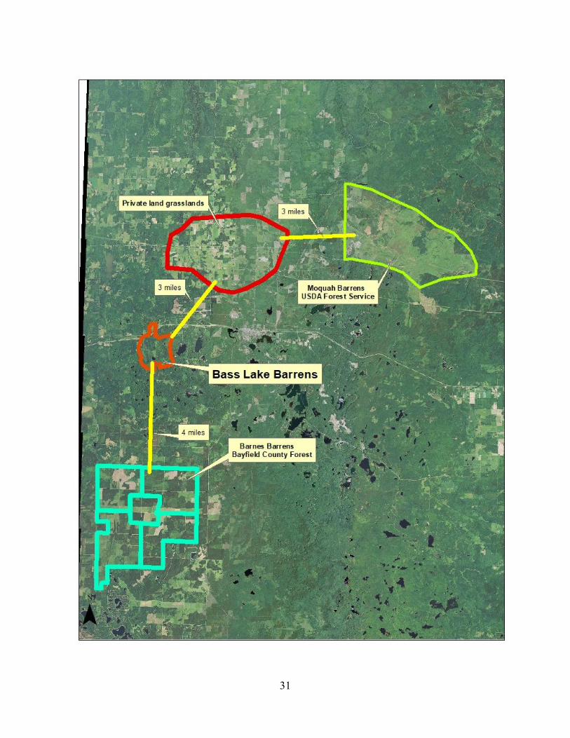
The BLBMA would establish and maintain an important barrens habitat corridor (stepping stone)
that will provide connections with other established barrens habitats, in particular the BBMA,
Moquah Barrens (managed by the USFS), and open fields north of highway 2 (see maps below
for more detail).
Below is some general information regarding current stand conditons located within the
BLBMA:
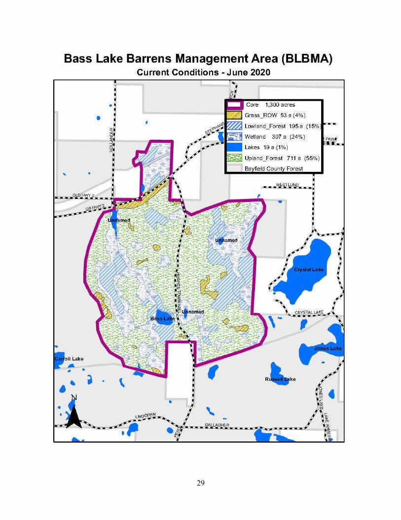
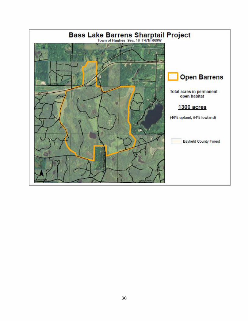
The BLBMA is approximately 1,300 acres in size.
A general classification of current acreage located with the BLBMA is as follows:
o Upland Forest: 710 acres.
o Upland Non-Forest: 53 acres.
o Lowland Forest: 195 acres.
o Lowland Non-Forest: 324 acres.
Of the stands classified as upland forest, roughly 577 acres are merchantable (or around
80%).
Of the stands classified as lowland forest, roughly 170 acres are merchantable (or roughly
85%).
24
Roughly 370 acres or about 30% of the BLBMA is currently “open”, which includes
grass openings, lakes, sedge meadows and road corridors.
About 750 acres or approximately 60% of the BLBMA is scheduled for management and
will be harvested through standard commercial timbers sales.
Approximately 160 acres or about 10% is currently classified as a young forest and
would be harvested at a later date.
Goals and Objectives
This special management area will develop and maintain essential open/brush barrens habitat
roughly four miles north of the larger BBMA. A combination of open/early successional
barrens, wetlands and transitioning shrub habitats will produce an important corridor (or stepping
stone) connection to other established barrens management areas (the BBMA, Moquah Barrens
and the Oulu grasslands/farm fields north of Highway 2).
Similar to the BBMA, it is necessary to develop principles and guidelines to meet specific
objectives. This plan defines operational parameters, guidelines and concepts that should be
followed to achieve the desired future condition. A few important objectives are as follows:
1. The location of the BLBMA was selected according to the WDNR NW Sands Habitat
Corridor Plan. A few of the more significant objectives of the Corridor Plan include:
a) The importance of suitable corridors to facilitate sharp-tailed grouse dispersal
between existing barrens habitats.
b) The development and maintenance of permanent open/brush barrens habitat
patches ≥ 1,280 acres in size.
Maintaining a recommended distance of roughly 3.1 miles between suitable
barrens habitat patches or stepping stones.
2. The BLBMA delineates approximately 1,300 acres as a special management area on the
Bayfield County Forest. In the short term, the existing forested stands would be
managed, as per normal, for the development of timber products. In the long term, all
25
forested stands would be converted to and maintained as open and brush prairie barrens
habitat.
3. Develop an approach for the management of existing forested stands and the post-harvest
conversion of each to an open/early successional barrens habitat.
4. Establish general guidelines for the development and maintenance of the barrens habitat.
5. Direct the Foresters of Bayfield County, through principles and guidelines, in the
sustainable management of the BLBMA.
Principles and Guidelines
When implementing the management plan, whenever possible, incorporate the following
principles and guidelines. Stand conditions and updated reconnaissance may influence future
planning and goals:
1. The management of existing, mature forested stands currently located within the BLBMA
will be accelerated. The goal will be to establish a timber sale on all mature stands by
2025, or earlier.
a. Younger stands, not currently ready for management, will also be accelerated and
harvested at the earliest possible time, when the stand produces a commercially
viable product.
2. Green tree retention (either as patches or individual trees), aesthetic management zones,
riparian management zones, or any other practice that retains scattered mature trees (post-
harvest) will be discouraged.
3. All forested stands will be converted to an open/early successional barrens habitat. This
will be accomplished through a combination of chemical and/or mechanical treatments,
as well as prescribed burning.
26
4. Once established, the entire BLBMA will be maintained in a permanently open/early
successional barrens habitat. Prescribed fire will be the preferred method of maintaining
the open barrens habitat. However, chemical and/or mechanical treatments may be
required if prescribed burning does not achieve the desired results.
a. Prescribed burning and/or other treatment cycles will be established in zones or
quadrants within the BLBMA. Once fully established, it is anticipated that a
designated portion of the “core” will be maintained in each successive year. The
frequency and/or type of maintenance activities will be somewhat fluid and
dependent upon a variety of influences, some of which include, the development
of undesirable plant species, encroachment of trees or other woody vegetation,
presence of invasive species, and results of previous treatments.
b. Many of the same approaches to managing the Core located within the BBMA
will be applied when maintaining the open barrens habitat within the BLBMA.
5. Fire management zones (fuel break roads) will be established at strategic locations
around and/or within the core and maintained to the same standards as County Forest
Primary Roads. All roads will have a 50 foot wide defensible zone maintained on both
sides of the road. These roads will help facilitate timely prescribed burns and reduce the
need to construct new fuel breaks every time a prescribed burn is conducted.
a. When new fuel breaks are necessary, straight paths or corridors will be
constructed to increase the efficiency of the prescribed burn. A fire management
zone or buffer may also be established when approaching privately owned lands.
6. Additional rolling, surrogate barrens (similar to those located within the BBMA) may be
incorporated into this plan. However, the roughly 1,300 acre “core” will be the primary
focal point of this special management area.
a. Forested stands located adjacent to, or in close proximity of, the BLBMA will be
managed as scheduled. However, some alteration to the treatment year and/or
silvicultural prescription may be warranted to maximize connectivity to the open
area and provide additional temporary barrens habitat (similar to the strategies
employed in the BBMA).
27
7. The monitoring of the local sharp-tailed grouse population, through genetic sampling
and/or GPS collaring, should be encouraged to provide information on the effectiveness
of this corridor area, as well as to help determine if additional modifications or rolling
barrens are needed to aid in dispersal.
8. The location of the BLBMA would establish a habitat corridor or stepping stone between
two open barrens landscapes that currently support viable sharp-tailed grouse
populations: the BBMA about 4 miles to the south and the Oulu grasslands (fields)
roughly 3 miles to the northeast.
9. Many of the additional monitoring and inventory needs/recommendations, as described in
the BBMA plan, will also apply to the BLBMA. Information obtained from such projects
will be used to determine the effectiveness of current treatments and whether
modifications or adjustments are necessary.
10. Work closely with State wildlife personnel and other natural resource professionals in
coordinating management strategies within the BLBMA. Management strategies are
fairly dynamic and often evolve based on a variety of factors, including, but not limited
to: best available science; lessons from past practices; responses to climate change;
impacts of insects, disease and/or wildfire; demonstrated wildlife habitat use patterns;
social pressures; etc. As the process develops and new information is realized,
adjustments and/or modifications to the plan are to be expected.
a. Refer to the DNR Barrens Best Management Practices document for additional
guidance and considerations. The Barrens BMP document can be located in the
Appendix.
Anticipated Results
The BLBMA will establish a critical NW Sands Landscape-level habitat connection, while
providing a unique and important open barrens/wetland complex for many rare and common
wildlife species. Some of the anticiapted benefits include, but are not limited to:
28
The BLBWA will provide a critical habitat connection between other larger existing
barrens projects in the region, thus benefiting numerous species, include sharp-tailed
grouse.
The barrens/wetland complex will greatly add to the importance of the total landscape for
waterfowl, northern harriers, sharp-tailed grouse and other barrens dependent species.
The barrens will provide rare and critical habitat for upland sandpipers, brown thrashers,
vesper sparrow, black bear, and badger
The existing sedge meadow wetlands will also benefit under management and will
provide habitat for American bittern, sora rails, sedge wren, Wilson’s snipe, and sandhill
cranes.
The barrens/shrub wetland transition will provide important habitat for golden-winged
warblers and woodcock, as well as other species that rely on a component of edge
habitats.
The barrens/aspen deciduous forest transition will provide additional adjacent habitats for
ruffed grouse, golden-winged warblers, and species of greatest conservation need.
The barrens/conifer forest transition will benefit wild turkey, whip-poor-wills, bobcat,
and other species that depend on this type of habitat.
The Department will continue to collaborate with the WDNR and other agencies regarding the
most effective and efficient ways to manage the barrens landscape. This plan is also intended to
be dynamic in scope. Modifications and/or adjustments to this plan may be necessary in
response to the results of inventory and monitoring projects, various field observations (growth
and development of desired habitat), new techniques, methods and/or concepts, or changes in
direction.
Refer to the annual Workplan for a detailed summary of anticipated work pertaining to the
BLBMA and the annual Accomplishment Report for a summary of completed activities.
29
30
31