Embed Size (px)
Citation preview

BEFORE THE CHRISTCHURCH REPLACEMENT DISTRICT PLAN INDEPENDENT HEARINGS PANEL
IN THE MATTER of the Resource
Management Act 1991 and the Canterbury Earthquake (Christchurch Replacement District Plan) Order 2014
AND IN THE MATTER of the Open Space
Stages 2 and 3 Proposals (and relevant definitions)
MEMORANDUM OF COUNSEL FOR CHRISTCHURCH CITY COUNCIL
REQUESTING CORRECTIONS TO DECISION 35 AND DECISION 34 (FULTON HOGAN / TEMPLETON COUNTRY CLUB)
OPEN SPACE AND RURAL CHAPTERS
2 September 2016
Barristers & Solicitors
D J S Laing / W M Bangma / H P Harwood Telephone: +64-4-499 4599
Facsimile: +64-4-472 6986 Email: [email protected] PO Box 82402 SOLICITORS WELLINGTON 6140

1 Decision 35 Minor Corrections Memorandum - SG Comments - 28327253 v 1.DOCX
MAY IT PLEASE THE PANEL:
Introduction and jurisdiction
1. This memorandum on behalf of the Christchurch City Council (Council)
respectfully requests the Panel make corrections and clarifications to, its
Decision 35: Open Space Chapter, dated 12 August 2016 (Decision).
Because of the interrelationship between the Decision and the Rural Decision
(Decision 34) in respect of the Fulton Hogan proposal at the Templeton Golf
Course, this memorandum also contains some requests which also relate to
the rural provisions.
2. The Panel has the power under clause 16 of Schedule 3 of the Order in
Council to make minor corrections to its decisions and proposals. Clause 16
states:
16 Minor corrections
(1) The hearings panel may, at any time, issue an
amendment to a decision to correct a minor mistake or
defect in a decision of the panel.
(2) This power includes the power to amend or correct a
proposal, provided that the amendment or correction is
made before the proposal becomes operative in
accordance with clause 16 of this order.
3. The Panel discussed the scope of this power in its decision making minor
corrections to Decision 9 Temporary Activities 6A, 6B and 6C.1 In summary,
clause 16 of Schedule 3 of the Order in Council is similar to, but not exactly the
same as, clauses 16 and 20A of Schedule 1 of the RMA. Clauses 16 and 20A
of Schedule 1 of the RMA use the words "minor error" rather than "minor
mistake or defect". The Environment Court in Re an application by
Christchurch City Council2 said:
An error is simply a mistake or inaccuracy which has crept into the plan.
The obvious example is a spelling mistake or reference to a wrong
1 Decision to Make Minor Corrections to Decision on Temporary Activities, dated 22 October 2015, at
paragraphs [3] to [9]. The Panel also discussed what changes of "no more than minor effect" are for the purposes of clause 13(6) in its Decision 9 Temporary Activities 6A, 6B and 6C at para [19] to [25].
2 Re an application by Christchurch City Council [1996] NZEnvC 97.

2 Decision 35 Minor Corrections Memorandum - SG Comments - 28327253 v 1.DOCX
paragraph number where there can be no doubt what number is
intended. It is analogous to the use of the slip rule in other Court
Proceedings. Thus rule 12 of the District Courts Rules 1992 make
provisions for correction of a judgment which contains a clerical mistake
or error arising from an accidental slip or omission. The fundamental
principle applicable to the use of the slip rule is that it may only be used
to correct a slip in the "expression" of a judgment not the "content".
4. The Environment Court determined a change would be within clause 16 of
Schedule 1 of the RMA if "the draftsperson seeks only to clarify what is clearly
intended by the document and does not in any way make a change to it which
alters its meaning".3
REQUESTS FOR CORRECTIONS
5. The Council seeks a number of corrections to the Decision to rectify mistakes
or inaccuracies or to assist users with navigating the Plan. In the Council's
submission, these corrections do not alter the substance (merits) of the
affected provisions. Consistent with the Council's practice, the Council has
included all of the corrections it has identified, including those of a very minor
nature in Attachment A to this application.
6. The Council respectfully requests that the Decision be corrected as set out in
this memorandum and Attachment A.
PLANNING MAPS
7. The Council's approach to the planning maps relating to this Decision is
explained in Attachment B to this memorandum. Attachment B also includes
requests for clarification and corrections in relation to the planning maps.
8. The Council will provide the Panel with amended maps separately on a USB
drive.
3 At page 11.

3 Decision 35 Minor Corrections Memorandum - SG Comments - 28327253 v 1.DOCX
REQUESTS FOR MINOR CORRECTIONS FOR THE PURPOSES OF
CLARIFICATION
Templeton Golf Course/Fulton Hogan Quarry
9. As foreshadowed in the Council's application for minor corrections to Decision
34: Chapter 17 Rural (Stage 2) (Rural Decision) the Council respectfully
requests some additional corrections and clarifications in relation to the Rural
Quarry Templeton Zone provisions of Chapter 17 which are set out below.
17.6A.1 Pre-requisite conditions for zone to apply
17.6A.1 c. iii.
10. Under Fulton Hogan's proposal which is anticipated by the deferred zoning, the
Council would be the administering body of the new golf course and
associated facilities. The Council observes however that under the pre-
requisite conditions in 17.6A.1 the Council has no ability to provide input into or
approval of the design and construction of the new golf course, even though it
would ultimately administer that land.
11. If that was not intended by the Panel, the Council respectfully submits that the
following amendment to 17.6A.1 c. iii. would correct the provision:
The delivery to the Council of an executed contract on terms acceptable to the Council as administering body, acting reasonably, between Fulton Hogan Limited and/or Templeton Golf Club and the party responsible for constructing a new golf course and associated facilities, including clubhouse, on the land shown on the Planning Maps as "Ru Q or OSCP (Templeton)". The contract shall include provision for the following: …
17.6A.1 c. iii. 4.
12. In relation to 17.6A.1 c. iii. 4., the Council respectfully asks whether the
inclusion of the word “potential” is necessary to achieve the Panel's intent for
that provision. The Council has a concern that the inclusion of the word
"potential" adds uncertainty and may be unnecessary.

4 Decision 35 Minor Corrections Memorandum - SG Comments - 28327253 v 1.DOCX
17.6A.1 c. iii. 4. B.
13. In relation to 17.6A.1 c. iii. 4. B., the Council notes that there are three Council
owned gravel reserves adjoining the existing quarry. Consequently, the
Council respectfully seeks clarification as to which two Council owned gravel
reserves the Panel is referring to in this pre-requisite condition (or all three).
14. The three Council owned gravel reserves adjoining the existing quarry are
shown on the diagram below as Pt Res 328 (SO 3430), Pt Res 329 (SO 3430)
and Pt Res 1378 (SO3430). To be abundantly clear in the plan, the Council
respectfully suggests that the legal descriptions of the correct parcels of land
be included in the rule.
Proposed bond - 17.6A.2.2 (C1) and 18.2.4.1.1 (C1)
15. In relation to the proposed bond, which is addressed in rules 17.6A.2.2 (C1)
and 18.2.4.1.1 (C1), the Panel made the following observations:
[419] Before leaving this topic we should say something about the
proposed bond/other security instrument which is, of course, intended to
manage risk to the Council. At this stage it is estimated that the golf course will
cost in the vicinity of $14 million, and the bond/security instrument is
intended to cover the actual cost of constructing the golf course and any
administration and enforcement costs. We accept that the rules must be

5 Decision 35 Minor Corrections Memorandum - SG Comments - 28327253 v 1.DOCX
tight enough for the proposed bond/security instrument to achieve its
purpose, and we are satisfied that this can be achieved. [our emphasis]
16. The Council respectfully considers that rules 17.6A.2.2 (C1) and
18.2.4.1.1(C1) could benefit from some amendments to reflect what the
Council understands the Panel's intention to be in relation to the bond, as
expressed in the paragraph above.
17. In particular, the Council suggests some amendments to the relevant matter of
control in both rules below to clarify that the terms of the bond are a matter
within the Council's control.
18. Further, as presently worded, the rules are not expressly clear as to whether a
guarantee for the bond obligation can be required by the provisions. The
Council considers, as a matter of practice, that such a guarantee would be
essential for the bond to achieve its purpose. The Council respectfully
anticipates that the Panel's intention was for such a guarantee to be within the
scope of the rules. If so, and to put the matter beyond doubt (and therefore
prevent any future interpretation issues), the Council respectfully suggests
some amendments to both rules below.
Rule 17.6A.2.2 (C1):
Activity The matters over which Council reserves its
control:
C1 Quarrying activity provided
that:
a. Construction of six golf
holes within the Open
Space Community Parks
Zone (Templeton) is
completed; and
b. A bond guaranteed by a
bank is entered into
between the Council and
Fulton Hogan Limited
and/or Templeton Golf
Club to ensure
completion of
construction of the golf
a. The extent to which conditions are
required in order to give effect to:
i. The Development Plan and its
requirements in Appendix 17.9.3
(as specified in Rule 17.6A.4.8);
ii. The Noise Management Plan,
including the noise limited as
specified in Rule 17.6A.4.9; and
iii. The Landscape and Ecological
Management plan (as specified
in Rule 17.6A.4.10); and
iv. The quarry site rehabilitation plan
(as specified in Rule 17.6A.4.11).
b. Details of a bond or other security
instrument The terms of the bank

6 Decision 35 Minor Corrections Memorandum - SG Comments - 28327253 v 1.DOCX
course and associated
facilities described in
Rule 17.6A.1 C. iii.
guaranteed bond, and its amount
being of sufficient sum to ensure
completion of construction of the golf
course and associated facilities in
accordance with Rule 17.6A.1 c. iii to
the satisfaction of the Council;
c. The extent to which conditions are
required to ensure that 18 golf course
holes are available for play at all times
across the Rural Quarry Templeton
Zone and the Open Space
Community Parks Zone (Templeton);
d. The extent to which conditions are
required to ensure that the design and
use of the proposed accesses do not
adversely affect the safety and
efficient functioning of the road
network .4
Rule 18.2.4.1.1 (C1)5
Activity The matters over which Council reserves its
control:
C1 c.a. A golf course, if it meets
the built form standards in
Rule 18.2.3, and provided
that:
c.b. a Landscape Plan has
been prepared by a suitably
qualified and experienced
expert showing:
i. …..
viii ….
d.c. A bond guaranteed by
a bank is entered into
between the Council and
Fulton Hogan Limited and/or
a. The extent to which conditions are
required in order to ensure:
i. The character of the golf course is
of a dry grassland indigenous to
the Canterbury Plains;
ii. Implementation of a Landscape
Plan;
iii. Creation of the Biodiversity
Conservation Area(s) specified in
the contract as required by Rule
17.6A.1.c.iii.3;
iv. Creation of a non-golf space as
specified in the contract as
required by Rule 17.6A.1c iii.4;
4 This text is an amendment requested in the Council's application for minor corrections for the Rural
Decision and has been included for completeness. 5 The Council also requests that the numbering of Rule 18.2.4.1.1 (C1) be corrected as show n above.

7 Decision 35 Minor Corrections Memorandum - SG Comments - 28327253 v 1.DOCX
Templeton Golf Club to
ensure completion of
construction of the golf
course and associated
facilities described in Rule
17.6A.1 c. iii.
b. Details of a bond or other security
instrument The terms of the bank
guaranteed bond, and its amount
being of sufficient sum to ensure
completion of construction of the golf
course and associated facilities in
accordance with Rule 17.6A.1 c. iii to
the satisfaction of the Council;
c. The extent to which conditions are
required to ensure that 18 golf course
holes are available for plat at all times
across the Rural Quarry Templeton
Zone and the Open Space
Community Parks Zone (Templeton);
DECISION 34: RURAL PLANNING MAPS
Correction to planning map 29 (RUQ or OCP Templeton Zone boundary)
19. The Council provided the Panel with a full set of planning maps to reflect the
Rural Decision as part of its application for corrections for that decision dated
26 August 2016. The maps showed the rural zoning required to give effect to
the Panel’s decision on the Fulton Hogan zone deferred zoning proposal. As
directed by the Panel on page 144 of the Rural Decision, the Council rezoned
the parcels listed as "RuQ or OCP Templeton Zone".
20. Council has since identified that there are two parcels of land with the same
legal description (Pt Lot 5 DP 19504) but only one of these was then identified
and rezoned "RuQ or OCP Templeton Zone" on the planning maps provided
with the Council's application for corrections to the Rural Decision.
21. This has resulted in the parcel indicated in the figure below (one of the two
parcels described as Pt Lot 5 DP 19504) inadvertently being shown as Rural
Quarry (RuQ) Zone in the planning maps. The Council has confirmed with
Fulton Hogan that it was intended that this parcel be part of its deferred zoning
proposal.

8 Decision 35 Minor Corrections Memorandum - SG Comments - 28327253 v 1.DOCX
22. Consequently, the Council respectfully requests that the correction be made.
To that end, the Council has annexed a corrected version of planning map 29
to this memorandum (Attachment C). The Council asks the Panel to replace
the previous version of planning map 29 with this version.
Planning map 36
23. The Panel’s zoning decision for the Templeton Golf Course site was
inadvertently not included in the planning maps provided with the Council's
application for corrections to the Rural Decision. A replacement planning map
36, which shows the Panel’s zoning decision for the Templeton Golf Cou rse
site as OCP or RuQT, is annexed to this memorandum as Attachment D.
DATED this 2nd
day of September 2016
__________________________________ D J S Laing / W M Bangma / H P Harwood
Counsel for Christchurch City Council

ATTACHMENT A – REQUESTS FOR CORRECTIONS
Correction sought to Decision
Paragraph and page references. Amendment requested
Paragraph [160] (Page 44)
McLeans Island Zone The Decision records at paragraph [160] that in relation to shooting ranges near Peacock Springs agreement was reached that the solution to the issue was to include a new Rule 6.1.4.2.11 in Chapter 6. In order to give effect to the agreed solution, the Council respectfully notes that Rule 18.4.2.4 D2 needs to be deleted, as follows:
D2 Shooting ranges located closer than 1 kilometre from the Peacock Springs Conservation Area as shown in Appendix 17.9.1.
Paragraph [162] (Page 45)
Footnote 83 contains a reference to Bruce Rule at pages 2-5, however, Bruce Rule did not give evidence in the Open Space hearing. The Council respectfully seeks clarification as to which evidence from Mr Rule it
is referring to.
Paragraph [184] (Page 50)
Reference is made in paragraph [184] to commercial-scale fireworks requiring resource consent within a setback. However the relevant Rule 18.4.2.1 P4 ii on page 179 of the decision references any fireworks, and does not specify “commercial-scale”. Accordingly, any fireworks are captured by the rule. The Council respectfully requests that the Panel insert "commercial-scale" fireworks into Rule 18.4.2.1 P4 ii rule to reflect the Panel's decision.
Paragraph [463](b) Deletion of P1 from Rule 18.3.2.1 (Page 121)
The Council notes that P1 in Rule 18.3.2.1 would need to be reinstated if the Definitions Revised proposal (CCC-Closing legal submission and Appendix E – Chapter 18 Open Space - Definitions, dated 16 August 2016) is accepted by the Panel.
The revised definitions proposal recommends removal of “minor sports facility” in the Open Space chapter and instead relying on the defined term recreation activities and facilities.

Correction sought to Proposal Provision
[page of decision]
Amendment requested
(additions in underlined bold text, deletions in strikethrough bold text) Policy 18.1.4 Policy – The role of open space and recreation facilities c.
(Page 128)
This policy was inserted to provide policy support for the specific provisions for privately (as opposed to publicly) owned metropolitan sports facilities contained in Table 1: Metropolitan Facilities – underlying zones, in 18.1A How to use the rules. These underlying zone provisions are only available to privately
owned metropolitan facilities and there are no equivalent provisions for the facilities/reserve land owned by the Council/Crown). The effect of the provisions is that, if a privately operated golf course ceases to operate as a golf course, the golf course can be developed for residential purposes by utilising the underlying zoning without a plan change. This option was intentionally not provided for publicly owned open space in the rules. Unless the Panel had intended a different direction for this policy in its decision, the Council respectfully requests that the reference to privately owned open spaces be reinstated in the Policy as follows: Policy 18.4.1
c. Provide for the redevelopment of privately owned open spaces no longer required for recreational activities in accordance with the rules of the zone most compatible with the surrounding environment.
Policy 18.1.4 Table 18.1.4 Open
Space Community Parks Zone F. (Page 128)
The Council respectfully suggests that for clarity Policy F (i) to (iii) refer to the sites as annotated on the
maps and/or to the address of the sites instead of referring to the "Rural Quarry (Templeton) Zone" or “Open Space Community Parks (Templeton) Zone”. The Council's preference is to refer to the addresses and the map annotation as set out below. The Council considers using the term "Rural Quarry (Templeton) Zone" or “Open Space Community Parks (Templeton) Zone may lead to confusion because that zone does not become "live" until the after the pre-conditions have been satisfied. The Council also notes that Policy (F.)(iii.) appears to refer to the future Rural Quarry Templeton Zone and the current Rural Quarry Zone as if they were one zone. The Council considers it necessary to clarify the distinction between the two sites as set out below. 18.1.4 Table 18.1.4 Open Space Community Park s Zone, Policy F(i) – (iii)
F. In the case of the Open Space Community Parks Zone (Templeton) at 325 Pound Road (shown as “RuQ
or OCP (Templeton)” on planning maps 29 and 36), a golf course, recreation activity, community facilities

and associated activities only if all of the following are satisfied prior to 31 December 2021:
i. the recreation reserve status applying to the site at 189 – 273 Pound Road Rural Quarry Templeton
Zone (shown as “OCP or RuQ (Templeton)” on planning map 29) is uplifted and placed upon the
land within the zone;
ii. any resource consent(s) to clear or fell indigenous vegetation, as required to undertake a quarrying
activity within the Rural Quarry Templeton Zone at 189 – 273 Pound Road (shown as “OCP or RuQ
(Templeton)” on planning map 29), is/are granted; and
iii. any quarrying activity undertaken within the Rural Quarry Templeton Zone at 189 – 273 Pound Road
(shown as “OCP or RuQ (Templeton)” on planning map 29) occurs in conjunction with development
of an international standard golf course in the zone on the land at 333 Pound Road shown as “RuQ
or OCP (Templeton)” on planning maps 29 and 36.
Policy 18.1.4 Table 18.1.4 Open Space Metropolitan Facilities Zone C. (Page 129)
While it is recognised that the meaning of the terms "multifunctional" and "co-location" have a degree of overlap, the Council respectfully considers that the terms have a subtle difference such that a minor clarification of this policy would be useful. In the Council's view, multifunctional use of a building or site is more the co-location of complementary or compatible activities. As such, the Council respectfully requests a minor amendment to Table 18.1.4 Open Space Metropolitan Facilities Zone c as follows: C. Capacity for multifunctional use, (i.e. co-location of complementary or compatible activities) and for
hosting city, regional, national or international events which provide entertainment to residents and visitors;.
Rule 18.1A – How to use the rules;
and 18.2.1, 18.3.1, 18.4.1, 18.5.1 and 18.6.1 (Pages 132, 134, 150, 176, 182 and 190)
The amendments introduced through Decision 35 replaced the ‘How to use the rules’ sections previously
set out at the beginning of each zone with a single set of provisions in Rule 18.1A. This rule is located at the start of the chapter, after the objectives and policies. The original location of “How to use these rules” at the start of each zone was specifically designed to allow for consistent and efficient functioning of the EPlan and its ease of use. It also allowed for the zone specific explanations to be located within the context of the applicable zone rules e.g. the 'underlying' zoning table for privately owned sites/facilities in the OMF zone (now Rule 18.1A(e.) Table 1). As a result, such zone specific information is now not easily found. It is respectfully suggested that in order to enable an easy link to the ‘How to use the rules’ section of the
chapter while using the Panel's approach, the words shown in the example below are inserted into 18.2.1, 18.4.1, 18.5.1 and 18.6.1:

18.2.1 Refer to Rule 18.1A for information on how to use these rules. Note that Rule 18.1A may contain information specific to the zone.
For Rule 18.3.1 the Council suggests additional words should be inserted as shown below:
18.3.1 Refer to Rule 18.1A for information on how to use these rules. Note that Rule 18.1A (b.), (e.) and Table 1 contain information specific to this zone.
Rule 18.2.2.1 P13; Rule 18.3.2.1 P18; and Rule 18.5.2.1 P9 (Page 136)
(Page 152) (Page 182)
The rules applicable to residential activity in the OCP Zone contained an exception from this Rule for residential activities within a heritage item. The wording of that exception has been changed in Decision 35, however, the intent of the exception may be clearer and better reflected if the activity specific standards for P13 are amended as follows:
P13
a. Unless Except as specified in P15, shall be located:
i. within an existing residential unit; or (…)
Similar amendments are recommended to the equivalent Rules in other zones as listed on the left.
Rule 18.2.2.1 P15; Rule 18.3.2.1 P21 Rule 18.5.2.1 P14; Rule 18.6.2.1 P17. (Page 137) (Page 152) (Page 183) (Page 192)
The word “additional” has been deleted from the wording of Rule 18.2.2.1 P15. The Council respectfully requests that the word be reinstated to make it abundantly clear that the activities listed in P15 are permitted in addition to all other permitted activities in Rule 18.2.2.1. The deletion of the word “additio nal” may inadvertently suggest that only the activities listed in P15 are permitted within a building listed as a heritage item which was not the intention of the rule. P15
The following additional activities within a building listed as a heritage item:
i. gymnasium;
ii. (…)
Rule 18.2.2.1 P20; Rule 18.5.2.1 P18; and Rule 18.6.2.1 P19.
To ensure consistency between the Activity specific standards (b.), (c.) and (d.) of the Rules listed on the left, the Council suggests the word “helicopter” be inserted before “movement” in (b.) and (c.) as shown below. “Helicopter movement” is a defined term and a hyperlink can then be used to the link the term with

(Page 137) (Page 152) (Page 184)
its definition. P20 a. Any heli-landing areas shall be limited to sites greater than 3000m² and located more than 450 metres from
any Residential Large Lot, Residential Small Settlement, Papakāinga, Residential Banks Peninsula or Commercial Banks Peninsula Zone;
b. There shall be no:
i. more than 12 flights (24 helicopter movements) in any calendar year; ii. more than five days of flights (helicopter movements) in any one month period; iii. more than three flights (six helicopter movements) in any one week;
iv. helicopter movements tak ing place within 25 metres of any residential unit unless that residential unit is owned or occupied by the applicant;
c. Any helicopter movements shall occur only between 0800 and 1800;
d. A log detailing the time and date of each helicopter movement shall be maintained and made available for inspection by the Christchurch City Council if requested.
Use of “Rule” notation for matters of discretion
(See page 164)
The Council notes that the word "Rule" has not been placed in front of all matters of control and discretion.6
The Council suggests "Rule" be added to the restricted discretionary tables in 18.3.4.1.3, 18.3.5.1.3.
Rule 18.2.2.3 RD13 Major sports facility at Elmwood, and Rule 18.2.2.4 D5 (Page 121) (Pages 142, 143)
Paragraph [462] (d) of the decision (on page 121) indicates that changes to the rules applicable to Elmwood Park have been made to align with the rules on the same proposal in the Specific Purpose (School) Zone of Chapter 21. The Council has noticed that the redrafting has led to some unintended consequences as follows:
1. The status of a major sports facility that does not contain any land in the adjoining Specific Purpose (School) Zone (Heaton Intermediate) will default to non-complying, when the default was intended
to be discretionary activity. At paragraph [196], the decision notes that: “ If a. and b. are not met, any development would default to fully discretionary activity”. This is because clause a. of Rule 18.2.2.3 has not been included in D5 (as it has for 18.2.2.3 b. c. or d). Clause a. needs to be included so that if it is not complied with it the activity can default to full discretionary.
The status of non-compliance with the landscaping requirements (c. and d.) was intended to be restricted discretionary activity (in the Final Revised Proposal), but by moving the provisions into RD13 and then also
6 As per paragraph [6] of the Panel's Minor Corrections to Decision 28 dated 31 August 2016.

into D5 it becomes full discretionary. This is also contrary to paragraph 196 -200 of the decision. The Council recommends the following amendments to Rule 18.2.2.4 D5: D5 A major sports facility on Lot 1, DP 12727 (that part of Elmwood Park located at 83D Heaton Street), that is not developed in conjunction with part of Lot 1 DP11232 (Heaton Intermediate Normal School) as required by Rule 18.2.2.3 RD13 a. and/or that does not meet the minimum contiguous net site area in Rule 18.2.2.3 RD13 b. or the landscaping requirements in rule18.2.2.3 c. and d. – RD13.
Rule 18.2.2.3 RD13 The Council notes that RD1 provides the default status of the activities in RD13 that do not meet the built form standards in Rule 18.2.3. For clarify and ease of use, the Council respectfully suggests an alternative way of setting the activity status for activities that do not comply with c and d of RD 13. The Council suggests that c. and d. be deleted from RD13 and instead be re-inserted as built form standards. In the Council's view, this would add clarity to RD13 which otherwise may imply that the landscaping is a critical part of a proposal for a major sports activity (which is the case for a. and b. but not for c. and d.). It is further recommended that the words “shall be a restricted discretionary activity except as specified in
rule 18.2.2.4 D1” at the bottom of RD13 be deleted or alternatively reference to D5 be included in the list for completeness: The amendments recommended are as follows:

RD13 A major sports facility on Lot 1, DP
12727 (that part of Elmwood Park located at 83D Heaton Street)
where:
a. it is developed in conjunction
with part of the adjacent Lot 1
DP11232 (Heaton Street
Intermediate Normal School,
125 Heaton Street);
b. the net contiguous site area set
aside for the major sports
facility is no less than 6,000 m²
across both sites.;
c. a 3 metre wide landscaped
area is established along all
Residential Suburban Zone
boundaries to be planted with
a minimum of 1 tree for every
10 metres of boundary; and
d. in addition to c, within on-site
car parking areas, 1 tree to be
planted for every 5 car
parking spaces.
shall be a restricted discretionary activity except as
specified in Rule 18.2.2.4 D1.
a. Minor and major sports facilities - Rule 18.7.1.
b. Park ing areas and public transport facilities -
Rule 18.7.5.
c. Traffic generation and access - Rule 18.7.3.
d. Landscaping and trees - Rule 18.7.4.
e.d. Overlook ing and privacy in relation to adjacent
residential properties and the remainder of the
school property.
f.e. Amenity of the neighbourhood - refer to Rule
21.6.5.1.
18.2.3.8 Landscaping Requirements a. The following landscaping requirements shall apply to a Major sports facility development on
that part of Elmwood Park located at 83D Heaton Street (Lot 1, DP 12727):
i. A 3 metre wide landscaped area shall be established along all Residential Suburban zone boundaries and shall be planted with a minimum of 1 tree for every 10m of boundary; and
ii. Within on-site car parking areas, 1 tree shall be planted for every 5 car parking spaces.

It is noted that changes would also be required to be made to the Specific Purpose (School) Zone Rules 21.6.3.4 D4 and 21.6.3.3 RD6 if the Panel agree to these changes because the activity status when a. is not complied with also defaults to non-complying rather than discretionary as indicated in the Decision (paragraphs [196] to [200]). The landscaping provisions also default to full discretionary as per Rule 21.6.3.4 D4, instead of restricted discretionary.
Rule 18.2.2.3 RD14; Rule 18.3.2.3 RD10; Rule 18.5.2.3 RD13; Rule 18.6.2.3 RD10 (Page 142)
(Page 154) (Page 186) (Page 195)
The cross reference to the Matters of Discretion in 9.4.3 needs to be updated to 9.6.3 following the
numbering change in Chapter 97. This applies to all activities listed on the left.
Additionally, as activity RD11 is deleted from Rule 18.2.2.3 RD14 (and deferred to Chapter 6), a numbering amendment is needed in RD14 as shown below.
RD14 Any activity listed above as RD1 –
RD1011 which is located within the Coastal Environment overlay area.
a. Refer to Matters of discretion for activities in the
Coastal Environment in 9.4 6.3
Rule 18.2.3.5; and Rule 18.5.3.4 (Pages 146 and 189)
Decision 35 introduced an exclusion for poles/light support structures from the recession planes built form standards in Rule 18.2.3.5 and 18.5.3.4. No equivalent exemption has been provided for in the Open Space Metropolitan Facilities, Open Space McLeans Island or Open Space Water and Margins Zones. The Council respectfully seeks clarification as whether this was intentional or whether the Panel intended the exclusion to apply in all open space zones.
Rule 18.2.3.6 Building footprint, site coverage and impervious surfaces Table 1
(Page 147)
At Rule 18.2.3.6 Table 1 column d, the provision needs to be corrected to include k. 466-488 Yaldhurst Road (Yaldhurst Recreation and Sports Facility). It is recommended that the clause be amended as follows:
18.2.3.6 Table 1 d. Greater than 10,000m2 in area unless specified in e. to j. k. below
Rule 18.2.2. Activity status tables
and Rule 18.2.4 Area Specific Rules – Open Space Community
Rule 18.2.4 cross references to Rule 18.2.2 and requires compliance with Rule 18.2.2 unless specified
otherwise in 18.2.4. In 18.2.2.1 P8 a golf course is a permitted activity on sites greater than 10,000sqm. However in 18.2.4.1.1 a golf course is a controlled activity subject to conditions and the built form standards
7 Chapter 19 - CCC Closing legal submission, dated 22 March 2016

Parks Zone (Page 134) (Page 148)
in 18.2.3. The Council suggests that it is clarified in the rules that a golf course in the Open Space Community Parks Zone (Templeton) is a controlled activity and that P8 of Rule 18.2.2.1 P8 does not apply to the Templeton site. The following amendment is recommended:
18.2.4 Area specific rules – Open Space Community Parks Zone The following rules apply to the areas specified. All activities are subject to Rule 18.2.2 (excluding 18.2.2.1 P8) and Rule 18.2.3 unless specified otherwise in 18.2.4. It is further suggested that the clause above would be clearer f it was included within 18.2.4.1.
Rule 18.3.2.1 P21 (Page 152)
In addition to including the word "additional" as discussed above, the Council suggests clause i. be deleted for consistency.
As part of the mediation agreement with the Crown, any activities listed for a heritage item building which duplicated the general list of permitted activities within the zone were deleted to avoid unnecessary duplication. Inadvertently, activity “i. recreation activity and/or facility” was not deleted from P21 in Rule 18.3.2.1 and for consistency with similar rules in other Open Space Zones, the Council recommends that P21 is altered as follows: P21
The following additional activities within a building listed as a heritage item:
i. recreation activity and/or facility;
i.ii. guest accommodation;
ii.iii. residential activity;
iii.iv. cultural facility.

Rule 18.3.2.3 RD15 and RD16 [154] [155]
Due to deletion of some restricted discretionary activities in Rule 18.3.2.3, the numbering of RD15 and RD16 no longer follows the numbering sequence. The Council respectfully requests that RD16 be shifted to follow RD10 and be renumbered to RD11 while RD15 (to be deleted when Chapter 6 provisions are confirmed by the future decision) can follow and retain its original number until deleted. The proposed amendments are shown below:
RD10 Any activity listed in Rules 18.3.2.1 P1 – P25
that does not meet one or more of the built form standards in Rule 18.3.3, unless otherwise specified
As relevant to the built form standard that is not met:
a. For rules 18.3.3.1, 18.3.3.2 and 18.3.3.3 - Setback
from boundaries – Rule 18.7.16.
b. Outdoor storage – Rule 18.7.17.
c. Building height - Rule 18.7.18.
d. Recession Planes – Rule 18.7.19.
e. Water supply for firefighting – Rule 18.7.20.
RD11 Any activity listed in Rules 18.3.2.3 RD1 -RD10 located within the Coastal
Environment overlay area.
a. Matters of discretion for activities in the
Coastal Environment in 9.4.6.3.
RD15 [Deferred to Chapter 6 General Rules] e. [Deferred to Chapter 6 General Rules]
RD16 Any activity listed in Rules 18.3.2.3 RD1 -
RD10 located within the Coastal Environment overlay area.
f. Matters of discretion for activities in the
Coastal Environment in 9.4.3.
Rule 18.3.3.9 Landscaping and trees (Page 160)
In clause a. iv. reference is made to a. to c. above when the numbering has changed. It is recommended that this clause be amended as follows: 18.3.3.9 Landscaping and trees a. ….
iv. The landscaped area along the Curletts Road (State Highway 75) frontage… in accordance with a.
to c. i to iii. above to minimise…
18.3.4.1.3 RD2
(Page 163)
Matters of discretion column:
Is it intended that matter of discretion 18.7.16 - Setback from boundaries apply to a non-compliance with
Rule 18.3.3.9 Landscaping and vegetation and Rule 18.3.3.3 Outdoor storage? If not it is recommended that this reference to these rules be deleted.

Rule 18.5.2.1 P13 (Page 183)
It is recommended that the word “additional” is inserted into P13 to make it clear that the activities listed in P13 are permitted in addition to all other permitted activities in Rule 18.5.2.1. The current wording may suggest that only the activities listed in P13 are permitted within the ON Zone at Ferrymead which was not the intention of the rule. It is recommended that P13 is altered as follows: P13
The following additional activities in the Open Space Natural Zone at Ferrymead:
i. Golf course,
ii. (…)
Rule 18.6.2.3 RD4 (Page 194)
All restricted discretionary activities listed in this Rule refer to “Any activity listed in Rule …”. RD4 is an exception referring to “Any permitted activity listed in Rule …”. For consistency it is recommended that the
rule is amended as follows:
18.6.2.3 RD4
Any Permitted activity listed in Rule 18.6.2.1 P12 ….”
Rule 18.6.2.4 D2 (Page 195)
As a result of renumbering the following minor amendments are recommended to this rule to: 1. replace the reference to RD11 with RD9 (amended number for “The future Pavilion building at 794
Colombo Street” restricted discretionary activity), 2. add a reference to 18.6.2.1 P7 in exceptions for clarity.
In addition as a result of an agreement8 reached with submitters Ngāi Tahu Justice Holdings/ Science Alive
(#3652) the discretionary activity D3 (in the hearing version of Chapter 18 text, dated 17 February 2016)
was deleted on the basis that the built form standard 18.6.3.7 (Maximum building footprint ) would control the size of new buildings /additions to buildings on the submitter’s site (refer 18.6.2.1 P24 and P25). Following further mediation with the Crown, it was agreed to delete built form standard 18.6.3.7 and rely on activity specific standards for controls on the maximum floor area of new buildings. Inadvertently, the deletion of 18.6.3.7 resulted in no controls for new buildings on the Science Alive site (P24 and P25). It is recommended that activities P24 and P25 are added to the list of activities in D2 which default to discretionary status if they require a new building. It is recommended that to resolve this unintended consequence of deleting the built form standard relating
8 Chapter 18, 3652 Ngāi Tahu Justice holdings and NZ Science and Technology Trust and CCC - Joint memorandum of agreements reached, dated 29 January 2016.

to the maximum building footprint (ex 18.6.3.7) the following amendments also be made so that D2 now reads with all amendments proposed as follows: D2 Any Permitted Activity listed in Rules 18.6.2.1, P4, P8, P9, P10, P13, and P20, P24, and P25 which requires the
construction of a new building except as specified in Rules 18.6.2.1 P7 and 18.6.2.3 RD1 and RD911.
Rule 18.6.2.4 D3 (Page 195)
This discretionary activity refers to development within an area defined in Appendix 14.10.10.2 Outline Development Plan (Wigram). The area referred to in the Appendix has been developed and is no longer subject to the ODP provisions. The Appendix has now been deleted from Chapter 14 and as a consequence D3 needs to be deleted from 18.6.2.4:
D3
Any activities and development within the area subject to the Outline development plan requirements in
Appendix 14.10.10.2 – Residential Established New Neighbourhood (Wigram) Open Space Network (refer also to Rule 14.6.4.3).
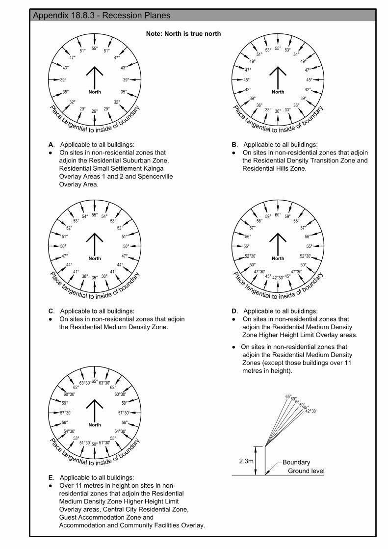
Appendix18.8.3 (Page 213)
An error in Appendix 18.8.3 – Recession Planes, diagram E. needs to be amended by inserting the word “Facilities” into the name of the “Accommodation and Community Facilities Overlay” referred to in E.
Chapter 8 – Subdivision, Appendix 8.6.14
The decision deletes Appendix 8.6.14, originally proposed to be inserted into Chapter 8. It is recommended that the placeholder for that appendix in Chapter 8 is amended to read: 8.6.14 – Appendix 8.6.14 – 27 Hunters Road This number is not used.

ATTACHMENT AA – APPENDICES 18.8.1 – 18.8.4
Appendices 18.8.1 – 18.8.4 have been amended to reflect replacement of Outline Development Plan with Development Plan and are attached for completeness.


North
47°
51°55°
51°
47°
43°
39°
35°
32°
29°26°
29°
32°
35°
39°
43°
North
55°
47°
45°
30°33°
39°
42°
45°
53°51°
49°
53°51°
49°
47°
36°33°
36°
39°
42°
North
55°
51°
50°
35°38°
44°
47°
50°
53°
52°
54°53°
52°
51°
41°38°
41°
44°
47°
54°
North
60°
56°
55°
58°
57°
45°
50°
59°
47°30'
52°30'
42°30'
59°58°
57°
56°
55°
52°30'
50°
47°30'45°
North
65°
59°
50°
56°
62°62°
59°
53° 53°
56°
63°30'
60°30'
57°30'
54°30'
51°30'51°30'
54°30'
57°30'
60°30'
63°30'
Boundary
Ground level
55°
45°
65°60°
50°
42°30'
Note: North is true north
2.3m
yra
dnuob fo edisni ot laitne
gnat
ecal
P
yra
dnuob fo edisni ot laitne
gnat
ecal
P
yra
dnuob fo edisni ot laitne
gnat
ecal
P
yra
dnuob fo edisni ot laitne
gnat
ecal
P
yra
dnuob fo edisni ot laitne
gnat
ecal
P
Overlay Area.
Overlay Areas 1 and 2 and Spencerville
Residential Small Settlement Kainga
adjoin the Residential Suburban Zone,
● On sites in non-residential zones that
. Applicable to all buildings:A
Residential Hills Zone.
the Residential Density Transition Zone and
● On sites in non-residential zones that adjoin
. Applicable to all buildings:B
the Residential Medium Density Zone.
● On sites in non-residential zones that adjoin
Applicable to all buildings: .C
metres in height).
Zones (except those buildings over 11
adjoin the Residential Medium Density
● On sites in non-residential zones that
Zone Higher Height Limit Overlay areas.
adjoin the Residential Medium Density
● On sites in non-residential zones that
. Applicable to all buildings:D
Accommodation and Community Facilities Overlay.
Guest Accommodation Zone and
Overlay areas, Central City Residential Zone,
Medium Density Zone Higher Height Limit
residential zones that adjoin the Residential
● Over 11 metres in height on sites in non-
. Applicable to all buildings:E
Appendix 18.8.3 - Recession Planes

NORTHKEY
Land parcel boundary
20m building setback
Existing boundary shelterbelts
Primary vehicle entrance
Area 2
Area 3
0
SCALE (m) 1:2,5000 at A3
20 40 60 801020
special conditions1 Area 8.8.4(b) for1 - Refer to 1Area
5m landscape setback1
Tilia spp. - (lime tree) Populus yunnanensis - (Chinese poplar)
- (crow's nest poplar) Populus nigra x euramericana 'Crows Nest'
Pittosporum eugenoides - (lemonwood)
Liriodendron tulipifera 'Fastigiata' - (upright tulip tree)
Alnus cordata - (Italian alder)
list or an alternative species approved by CCC:
planting, and shall be a species from the following
setback shall be a minimum of 3m tall at the time of5 metre landscape13. The trees to be planted in the
0 metres apart.1 more than the boundary, and the trees in each row planted no
the outer row set back a minimum of 5 metres from
contain two staggered rows of trees 8 metres apart,
5 metre landscape setback shall be grassed, and shall1 lawfully established feature, the surface of the
2. Except where occupied by a vehicle crossing, or by a
row of trees. as the surrounding vegetation, to create a continuous
planted with the same species and at the same spacing
shall be retained, and any gap within them shall be
. Existing boundary shelterbelts shown on the plan1
Landscaping Requirements
Development plan boundary
Development Plan
Yaldhurst Recreation and Sports Facility
8.8.4(a)1Appendix
pp104001.dgn22/08/2016Date:
Map:
Christchurch City CouncilAssets and Network UnitTechnical Services and Design
145m
200m
80m
175m
200m
100m
15m
20m
15m
20m
15m
20m
15m
20m
Area 3
Area 1
Area 2
466-482
8.8.4(b))1(Refer to
8.8.4(a) Yaldhurst Recreation and Sports Facility Development Plan1Appendix
YALDHURST RD

NORTH
Development Plan
Yaldhurst Recreation and Sports Facility
8.8.4(b)1Appendix
Special conditions for Area 1
into Council records as RMA92023228 pages 10 and 11.
Light Aiming Angles Sheet 3 and Playing Fields A & B Flood Light Aiming Angles Sheet 5 entered
7. Flood lighting shall be angled in accordance with the Connetics Plans Main Playing Field Flood
900 seats.
maximum of 100m from the eastern site boundary and shall not exceed provision for a total of
1. Scaffold stand seating shall be located a minimum of 80m from the northern site boundary and a
provision for a total of 400 seats.
boundary and a maximum of 100m from the eastern site boundary, and shall not exceed
2. Seating within the clubroom stand shall be located a minimum of 175m from the northern site
adverse lighting effect on adjoining properties.
lighting design, installation and operation shall be implemented to control and minimise any
Ltd and entered into Council records as RMA92023228 pages 141 to 144 in relation to exterior
3. All measures as described in the Environmental Lighting Effects Report prepared by Connetics
Plan entered into Council records as RMA92023228 page 7.
4. Car parking and flood lighting shall be limited to the locations as shown on the Connetics Locality
in height.
headframes (to which floodlights will be mounted as shown on Sheet 11) shall not exceed 21m
Plan Lighting Towner Detail Sheet 11 entered into Council records as RMA92023228 page 8 and
5. Flood lighting serving the full sized pitches shall be constructed in accordance with the Connetics
RMA92023228 page 9 and shall not exceed 9.7m in height to the bottom of the luminaire.
Plan Training Field Horizontal Illuminance and Spill Light Sheet 6 entered into Council records as
6. Flood lighting serving the mini pitches shall be constructed in accordance with the Connetics
pp104001.dgn22/08/2016Date:
Map:
Christchurch City CouncilAssets and Network UnitTechnical Services and Design
8.8.4(b) Yaldhurst Recreation and Sports Facility Development Plan1Appendix

ATTACHMENT B - OPEN SPACE DECISION 35 MAPS
1. The Council seeks confirmation from the Panel that its approach to the maps, as described below, is appropriate.
2. The Open Space Water and Margins and Open Space Community Park zones (OWM/OCP) confirmed by Decision 269 have been greyed on
the Decision 35 maps.
3. The Decision 35 maps include sites that were greyed out at Stage 1 and notified as open space at Stage 2 except as altered by decisions on
individual submissions or zoning confirmed by Decisions 10 and 17 (Residential) and Decision 34 (Rural). The approach is as follows:
(a) Where the decision on the change of zoning was part of the Rural decision, Decision 34 maps will display the appropriate zoning.
(b) Decision 35 does not alter transport zoning of the coastal unformed roads as notified and as confirmed by Decision 12, therefore
the Transport Zone is not displayed on Decision 35 maps.
(c) As Decision 10 and 17 maps (Residential Stage 1 and 2) did not display any sites rezoned to Open Space through submissions
considered at Residential hearings, the Decision 35 maps show these rezoned sites. The list of relevant submissions is contained
in Attachment A (section 4) to Ms Carter's evidence in chief for the Stages 2 and 3 Open Space Proposal.10
126 Puriri Street
4. The Council respectfully seeks clarification in relation to 126 Puriri Street. Schedule 4 of Decision 35 confirms the as notified OWM zoning
over part of the site at 126 Puriri Street, however, in an earlier Decision 26 the Panel requested that the Council confirm t he Residential
9 Decision 26, Schedule 2 – The Open Space zone maps show ing the rezoned OWM and OCP areas in red and circled, dated 8 July 2016
10 Chapter 18 Open Space (stages 2 and 3), evidence in chief of Janice Carter – Planning, 19 January 2016.

Suburban (RS) zoning for the site instead (along with the site at 23 Thornycroft Street). The subsequent Council memorandum11
confirmed
the RS zoning for this site. The Council respectfully requests confirmation that the earlier Decision 26 zoning decision (RS) prevails.
Sites with notified double zoning (deferred)
5. Decision 35 maps include the following sites with notified double zoning. The decision on these double zonings were deferred from Stage 1
to Stages 2 and 3 in response to the Council's application for deferral:12
(a) Sites that were notified with a Stage 1 residential zoning but were re-notified at Stage 2 with an open space zoning. The Panel
directed that the decisions on the zoning of these sites was deferred to the Stage 2 hearings, including open space.13
These sites
were greyed out on the Decision 10 maps and their Open Space zoning was confirmed in Schedule 2 of Decision 35.
(b) Sites that were notified with a Stage 1 commercial or industrial zoning but re-notified at Stage 2 with an open space zoning and
deferred by Panel direction to the open space hearing. These were inadvertently not greyed on the Decision 11 maps. However,
Decision 35 confirms the open space zoning of these deferred sites in Schedule 2 of the decision, therefore the Council anticipates
that the later in time decision (Decision 35) prevails.
6. The Council respectfully requests the following corrections in relation to sites with notified double zoning:
(a) Schedule 2 of Decision 35 lists the site at 410R Selwyn Street as a site to be zoned Open Space Community Park. This site has
been since identified as forming part of the Addington Cemetery and its Specific Purpose (Cemetery) Zoning was confirmed by
11
Memorandum of behalf of CCC (in relation to Open Space and Decision 26) confirming zonings of excepted properties, dated 28 July 2016. 12
CCC application to set aside land from Stage 1 proposals w here it has been re-notif ied at Stage 2, dated 17 June 2015. 13
Order made in terms of application to set aside land from Stage 1 proposals re CCC memo 17 June 2015, dated 26 June 2015
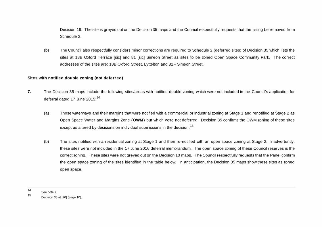
Decision 19. The site is greyed out on the Decision 35 maps and the Council respectfully requests that the listing be removed from
Schedule 2.
(b) The Council also respectfully considers minor corrections are required to Schedule 2 (deferred sites) of Decision 35 which lists the
sites at 18B Oxford Terrace [sic] and 81 [sic] Simeon Street as sites to be zoned Open Space Community Park. The correct
addresses of the sites are: 18B Oxford Street, Lyttelton and 81F Simeon Street.
Sites with notified double zoning (not deferred)
7. The Decision 35 maps include the following sites/areas with notified double zoning which were not included in the Council's application for
deferral dated 17 June 2015:14
(a) Those waterways and their margins that were notified with a commercial or industrial zoning at Stage 1 and renotified at Stage 2 as
Open Space Water and Margins Zone (OWM) but which were not deferred. Decision 35 confirms the OWM zoning of these sites
except as altered by decisions on individual submissions in the decision.15
(b) The sites notified with a residential zoning at Stage 1 and then re-notified with an open space zoning at Stage 2. Inadvertently,
these sites were not included in the 17 June 2016 deferral memorandum. The open space zoning of these Council reserves is the
correct zoning. These sites were not greyed out on the Decision 10 maps. The Council respectfully requests that the Panel confirm
the open space zoning of the sites identified in the table below. In anticipation, the Decision 35 maps show these sites as zoned
open space.
14
See note 7. 15
Decision 35 at [20] (page 10).

Table 1: sites notified with a residential or commercial zoning in Stage 1 which should be open space
Property Address &
legal description
Map No.
Stage 1 notified zoning / Decision 10 or Decision 11 maps
Stage 2 notified OS zoning maps Reason for change Request to confirm the
correct zoning in Decision 35
28 Shearer Avenue RES 4474 (DP 12329), RES 4889 (DP 17732) and RES 4777 (DP 17732)
24
Double zoning (RMD/OCP) – not deferred. CCC owned playground/open space.
Confirm zoning as OCP
136 Shaw Avenue (aka 100 Shaw Avenue) - Thomson Park RES 4467 (DP 3213), Lot 3 DP 3276
26
Double zoning (RS/OCP) – not deferred. CCC owned open space, including access lots to the park.
Confirm zoning as OCP

Property Address &
legal
description
Map No.
Stage 1 notified zoning / Decision 10 or Decision 11 maps
Stage 2 notified OS zoning maps Reason for change Request to confirm the
correct zoning in
Decision 35 111 Berkshire Drive - access to Crosbie Park Lot 555 DP 61836
30
Double zoning (RS/OCP) – not deferred. CCC owned open space, including access lots to the park. (Note, part of the access lot is zoned Transport – Decision 12)
Confirm zoning as OCP
63 Picton Avenue Lot 1 DP 302845
31
Double zoning (RS/OCP) over the northern part of the park – not deferred. CCC owned open space.
Confirm zoning as OCP

Property Address &
legal
description
Map No.
Stage 1 notified zoning / Decision 10 or Decision 11 maps
Stage 2 notified OS zoning maps Reason for change Request to confirm the
correct zoning in
Decision 35 9 Eveleyn Couzins Avenue RES 5233 SO 10548
32
Double zoning (RMD/OCP) of thin strip of land along the western boundary of the park – not deferred. CCC owned open space.
Confirm zoning as OCP
82 Avonside Drive (Beverley Park) Lot 3 DP 335994 and Lot 3 DP 74519
32
Double zoning (RMD/OCP) of park access strip – not deferred. CCC owned open space.
Confirm zoning as OCP

Property Address &
legal
description
Map No.
Stage 1 notified zoning / Decision 10 or Decision 11 maps
Stage 2 notified OS zoning maps Reason for change Request to confirm the
correct zoning in
Decision 35 24 Admirals Way (part of), adjacent to the deferred 60 Owles Terrace RS 42406 (SO 16834) shown as RS
33
Double zoning (RS/OCP) – not deferred. CCC owned open space.
Confirm zoning as OCP
8 Skylark Lane (aka 84 Radley Street) Lot 11 DP 67544
39
Double zoning of the western section of the park (RS/OCP) – not deferred. CCC owned open space.
Confirm zoning as OCP
9F Arran Crescent (aka 434D Linwood Avenue) Pt RSs 39, 464, 84 Canterbury District
39
Double zoning (RSDT/OCP) over south-east corner of the park – not deferred. CCC owned open space – Linwood Park.
Confirm zoning as OCP

Property Address &
legal
description
Map No.
Stage 1 notified zoning / Decision 10 or Decision 11 maps
Stage 2 notified OS zoning maps Reason for change Request to confirm the
correct zoning in
Decision 35 194 Milton Street Lot 2 DP 6287
39
Double zoning (RMD/OCP) – not deferred. CCC owned open space (Bradford Park).
Confirm zoning as OCP
21R St Lukes Street Lot 3 DP 72200, Lot 13 DP 341054 and Lot 29 DP 370714
40
Double zoning (RS/OCP) – not deferred. CCC owned open space.
Confirm zoning as OCP

Property Address &
legal
description
Map No.
Stage 1 notified zoning / Decision 10 or Decision 11 maps
Stage 2 notified OS zoning maps Reason for change Request to confirm the
correct zoning in
Decision 35 30 Coppinger Terrace Heathcote River (part of Nash Reserve) Lot 137 DP 303811, Lots 277, 278 DP 325867 (Also see 22R Date Crescent below)
44
Double zoning (RS/OCP) – not deferred
Confirm zoning as OCP except as specified in paragraphs 12 and 13 of Attachment B below.
22R Date Crescent Heathcote River (part of Nash Reserve) Lot 565 DP 375351 (Also see 30 Coppinger Terrace above)
44
Double zoning (RS/OCP) – not deferred
Confirm zoning as OCP except as specified in paragraphs 12 and 13 of Attachment B below.

Property Address &
legal
description
Map No.
Stage 1 notified zoning / Decision 10 or Decision 11 maps
Stage 2 notified OS zoning maps Reason for change Request to confirm the
correct zoning in
Decision 35 Annies Lane – part of access to properties at 1, 2, 2A, 3, 3A, 4, 5, 5A, 6A, 6B, 7, 7A, 8, 9 Annies Lane Part of Lot 569 DP 375351
44
Double zoning (RS and RMD/OCP) – not deferred Small areas of landscaping maintained by CCC along a private shared access way adjacent to Nash Reserve
Confirm zoning as OCP
50 Voelas Road Pt Secs 258, 259 Lyttelton Town
52
Double zoning (RBP/OCP) – not deferred CCC owned land (part reserve, part road), partly occupied by private buildings in the south-east corner.
Confirm zoning as OCP (for the entire area re-notified as OCP); and Confirm zoning as RBP (for the small triangle of land not re-notified as OCP)

Property Address &
legal
description
Map No.
Stage 1 notified zoning / Decision 10 or Decision 11 maps
Stage 2 notified OS zoning maps Reason for change Request to confirm the
correct zoning in
Decision 35 1 Seaview Terrace Pt RS 247 Canterbury Dist, Pt Secs 213, 214, 215 Lyttelton Town
52
Double zoning (RBP/OCP) – not deferred CCC owned recreation reserve
Confirm zoning as OCP for the entire site
Off 32 Emerson Crescent – Queen’s chain south of Coastal Cliff Reserve
58/61
Double zoning (RBP/OCP) – not deferred Crown owned Queen’s chain
Confirm zoning as OCP

Property Address &
legal
description
Map No.
Stage 1 notified zoning / Decision 10 or Decision 11 maps
Stage 2 notified OS zoning maps Reason for change Request to confirm the
correct zoning in
Decision 35 21 Marine Drive Pt Lot 2 DP 14050, Pt Lot 2 DP 14050, Lot 3 DP 14050, Lot 4 DP 14050
58/59
Double zoning (RBP/OCP) – not deferred CCC owned Coastal Cliff Reserve
Confirm zoning as OCP
11 Rue Grehan Lot 14 DP 41124
77
Double zoning (RBP/OCP) – not deferred CCC owned reserve (Waeckerle Reserve)
Confirm zoning as OCP

Property Address &
legal
description
Map No.
Stage 1 notified zoning / Decision 10 or Decision 11 maps
Stage 2 notified OS zoning maps Reason for change Request to confirm the
correct zoning in
Decision 35 47 Beach Road, Akaroa (Stanley Park) Pt Lot 1 DP 2869, Lot 2 DP 344385
77
Double zoning (RBP/OCP and CBP/OCP) – not deferred Owner: Department of Conservation (Stanley Park)
Confirm zoning as OCP Note: this will require amendments to Decision 11 – Commercial / Industrial Stage 1 (Note Commercial zones are under appeal) as well as Decision 10 - Residential Stage 1 maps
80 Rue Jolie, Akaroa Pt Section 14, Town Akaroa
77 / R5
Double zoning (CBP/OCP) – not deferred Owner: Department of Conservation (Rue Balguerie Playground)
Confirm zoning as OCP Note: this will require amendments to Decision 11 – Commercial / Industrial Stage 1 (Note Commercial zones are under appeal)

Property Address &
legal
description
Map No.
Stage 1 notified zoning / Decision 10 or Decision 11 maps
Stage 2 notified OS zoning maps Reason for change Request to confirm the
correct zoning in
Decision 35 1 Gladstone Quay (aka 4 Donald Street), Lyttelton Lots 2, 3 DP 307398
52 / R1
Double zoning (CBP/OCP) – not deferred Owner: CCC
Confirm zoning as OCP Note: this will require amendments to Decision 11 – Commercial / Industrial Stage 1 (Note Commercial zones are under appeal)
Correction requested for zoning of 32, 34, 36 and 34R Bronco Drive, Aidanfield
8. Four sites at 32, 34, 36 and 34R Bronco Drive, Aidanfield were notified as residential at Stage 1 and were subsequently notified as open
space (in part) at Stage 2. They were inadvertently not included in the Council's deferral application.16
The 15 June 2016 Decision 10 maps
show those parts of the four sites which were double zoned with residential zones.
9. The notified layout of the Open Space zoning in the Aidanfield area in Stage 2 was based on the operative City Plan and on the information
from the Greenspace unit of the Council regarding the indicative extent of the future reserves surrounding the Heathcote River headwaters
(Nash Reserve) in the Aidanfield subdivision. At the time of notification, not all of the land was developed or subdivided and the shape of
future reserves was based on the extent of the natural contour of the waterway ‘gully’. Subsequently, a new stage of the Aidanfield
subdivision was approved and new residential lots were created partly on the land previously anticipated to be open space.
16
CCC, Application to set aside land from Stage 1 proposals w here it has been re-notif ied at Stage 2, dated 17 June 2015

10. Conversely, part of the reserve created in the new subdivision (now known as Bronco Park) extends over the land anticipated to be
developed for residential purposes and zoned accordingly at Stage 1. As a result, the Stage 1 residential zoning (RS and RMD) needs to be
confirmed for the residential sites at 32, 34 and 36 Bronco Drive while the reserve site at 34R Bronco Drive needs to have it s stage 2 OCP
confirmed as notified at Stage 2.
11. The Council requests the following corrections be made, as set out in Table 2 below.

Table 2: Corrections for 32, 34, 36 and 34R Bronco Drive
Property
Address &
legal description
Planning Map No.
Stage 1 notified zoning / Decision 10 – 15 June 2016
maps
Decision 35 planning maps Reason for change Request to confirm the
correct zoning in Decision 35
34R Bronco Drive Lot 104 DP 484886
44
Double zoning (RS/OCP) – not deferred. CCC owned open space (Bronco Park). Note: While the entire site at 34R Bronco Drive is a CCC owned recreation reserve which could be zoned OCP in its entirety, only part of it was notified as OCP at Stage 2.
Confirm zoning as OCP (part) and RS (part)
32 Bronco Drive Lot 67 DP 484886
Double zoning (part RMD, part RS/OCP) – not deferred. Private owner: J A and P H Daly
Confirm Stage 1 part RS and part RMD zoning for the entire site (instead of OCP).
34 Bronco Drive Lot 66 DP 484886
Double zoning (RS/OCP) – not deferred. Private owner: FH Homes Limited
Confirm Stage 1 part RS and part RMD zoning for the entire site (instead of OCP).
36 Bronco Drive Lot 32 DP 484886
Double zoning (RS/OCP) – not deferred. Private owner: Xiupan Ye
Confirm Stage 1 part RS and part RMD zoning for the entire site (instead of OCP).

Correction to Decision 35 – Stage 1 zoning of sites deferred but not renotified as Open Space at Stage 2
12. The sites listed below were notified with residential zoning at Stage 1. They were also partly zoned as OCP at Stage 2 and included in the
Council's deferral application.17
Decision 35 specifically lists them in Schedule 2 (deferred sites) and confirms that they should be zoned
Open Space. However, the Council respectfully considers some corrections to the zoning should be made.
13. Inadvertently, the site at 2 Lane Street and small parts of the sites at 22R Date Crescent and 30 Coppinger Terrace were not renotified at
Stage 2 with Open Space zoning. While the sites are part of CCC land and reserves, due to a GIS error the full extent of the reserves was
not included in the rezoning for Stage 2. The Council therefore respectfully requests the Panel to confirm the Stage 1 Residential zoning for
the sites and parts of sites as shown in Table 3 below. The Council notes that Decision 10 maps showed these sites as zoned Residential
Suburban.
17
CCC, Application to set aside land from Stage 1 proposals w here it has been re-notif ied at Stage 2, dated 17 June 2015

Table 3: Requested corrections to deferred but not renotified sites
Property Address & legal
description
Planning Map No.
Stage 1 notified zoning Stage 2 notified OS zoning maps / Decision 35 planning
maps
Reason for change Request to confirm the
correct zoning in
Decision 35 22R Date Crescent (part) (part of Nash Reserve) 3 small parts of Lot 565 DP 375351
44
RS zoning deferred but not re-notified as OCP. CCC owned land (3 pockets with off-street public car parks, partly in Nash Reserve and partly in Transport Zone). While the appropriate zoning would be OCP or Transport no submission sought such rezoning from RS.
Confirm Stage 1/Decision 10 RS zoning
30 Coppinger Terrace (part) (part of Nash Reserve) A small part of Lot 137 DP 303811
44
RS deferred but not re-notified as OCP. CCC owned land (a pocket with off-street public car parks). While the appropriate zoning would be OCP or Transport no submission sought such rezoning from RS.
Confirm Stage 1/Decision 10 RS zoning
2 Lane Street (aka 25 Maronan Street) Lot 1 DP 18121
40
RMD deferred but not re-notified as OWM. CCC owned land (part of Heathcote River esplanade reserve) While the appropriate zoning would be OWM no submission sought such rezoning from RMD.
Confirm Stage 1/Decision 10 RMD zoning

ATTACHMENT C – REPLACEMENT PLANNING MAP 29

ATTACHMENT D – REPLACEMENT PLANNING MAP 36


![IN THE EMPLOYMENT COURT CHRISTCHURCH … · DAVID RODKISS v CARTER HOLT HARVEY LIMITED NZEmpC CHRISTCHURCH [2015] NZEmpC 147 [27 August 2015] IN THE EMPLOYMENT COURT CHRISTCHURCH](https://img.pdfslide.net/doc/110x75/5bc066c209d3f210098b7f8b/in-the-employment-court-christchurch-david-rodkiss-v-carter-holt-harvey-limited.jpg)