Embed Size (px)
Citation preview

BEFORE THE PALMERSTON NORTH CITY COUNCIL
IN THE MATTER OF
AND
IN THE MATTER OF
REGARDING
The Resource Management Act 1991
A Hearing of the Palmerston North City
Council before Independent Commissioner
Angela Jones
Application for land use consent by
Aokautere Land Holdings Ltd Stage 6F5
being LU 4085
STATEMENT OF EVIDENCE OF PHILIP HARVEY PIRIE

Introduction
1. My name is PHILIP HARVEY PIRIE. I am a LIcensed Cadastral and
Professional Consulting Surveyor and director of Pirie Consultants Ltd. j have
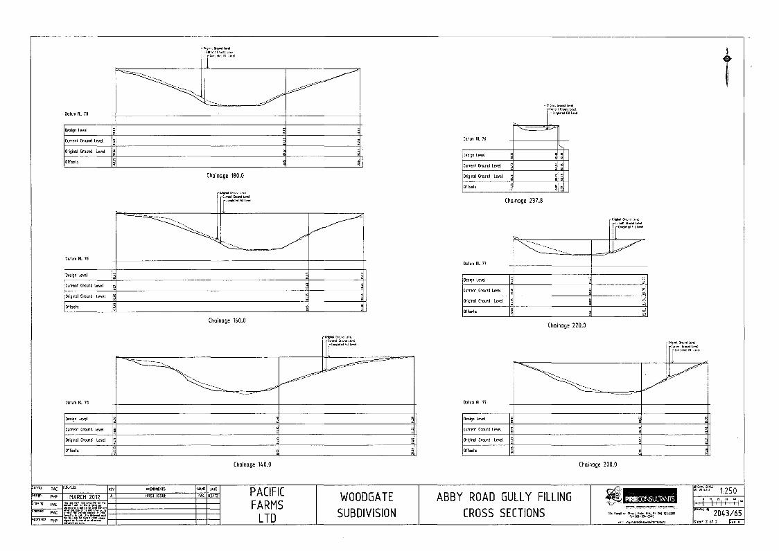
been practicing in the fields of surveying, resource management, land
development and civil engineering for over 37 years. I am a registered member
of the New Zealand Institute of Surveyors and the Consulting Surveyors of New
Zealand, and have also held various roles on the Manawatu Wanganui Branch
Committee.
~ [have provided expertise across alt professional fields that [ practise in for a
wide range of resource consent appIJcations, and have provided evidence at
hearings before Consent Authorities and the Environment Court. My principal
locations of business are within the lower North Island, principally within the
Palmerston North City Council, Manawatu District Council, Rangitikei District
Council, Tararua District Council, and Horowhenua District Council. Work has
also included projects elsewhere in both the North and South Islands. My
Clients are mostly private organisations and the general public who require
expertise and assistance in various matters.
3. I have considerable experience in providing a full range of services for the
design of subdivisions and housing developments within both rural and urban
settings. My firm, based in Palmerston North, has been In eXistence since 1960
and I have been the owner since 1993.
4. J have read the Environment Court's Code of Conduct for Expert Witnesses,
and I agree to comply with its provisions. My qualifications as an expert are
outlined above. i confirm that the issues addressed in this brief of evidence are
within my area of expertise. I confirm that I have not omitted to consider
material facts known to me that might alter or detract from the opinions
expressed.

Background
5. I have been continually engaged in the development of the Woodgate
subdivision by the applicant company and its predecessors since 2002 which
began initially with the compfetion of the construction of Johnstone Drive and
Ron Place from Pacific Drive. This work has continued since then and involved
the proposals for the filling of the Abby Road Gully and Johnstone Drive GuHy,
the development of the northern end of Johnstone Drive in stages, the
development of Coutts Way and proposals for the development of the
remainder of the farmland to the east that is bounded by neighbouring
properties of Moonshine Valley,
6, This application refates to the proposed filling, and aligned earthworks, of a
gully situated on Lot 2 DP 484516, CFR 706790; and part of Lot 1102 DP
519561, CFR 817001, being part of that land situated at 30 Abby Road and 33
Johnstone Drive. For ease of reference I refer to this gully, in this brief as the
"Abby Road Gully".
7. Abby Road Gully has previously been the subject of a resource consent, issued
in or about April 2007, under RM 2466 (the Initial Consent).
8. The Initiaf Consent issued as part of a wider scheme of development. relating to
the land then comprised in computer freehold registers Lot 97 DP 330144, CFR
123780 and Lot 99 DP 325883 CFR 104249.
9. The Initial Consent authorised the carrying out of substantive earthworks/land
remodelling works, and as a result of the grantrng of that consent. the landforms
surrounding, and entailing the Abby. Gully were signjficantly
3

modified/transformed during the construction period commencing July 2007 and
ending February 2008.
10. Work undertaken included building of slit control, removal of all vegetation,
construction of haulage routes into the gully, excavation of unsuitable material
from the gully floor, laying of subsoil drainage and filling of the gully floor,
Without limitation the works completed included, the batters surrounding the
Abby Road Gully being stripped, and reformed, the Abby Road Gully itself was
excavated, and subsoil drainage installed, the dimensions/batters, and
topography of the Abby Road Gully were substantively altered with the base
and the sides of changing in height by up to 2m, Approximately 1m of the base
of the gUlly was excavated to remove unsuitable material and then replaced
with compacted fill.
11. Exhibit A contains photos and videos of the extensive work being peliormed in
the gully during the 2007/8 construction season and shows how the gully has
been significantly modffied.
12. During the 2007/8 construction season earthworks also began on the nearby
Johnstone Drive Gully. A decision was made by the Company to concentrate
resources on the Johnstone Drive Gully earthworks while other matters relating
to the development of land near to the Abby Road Gully were being attended to.
This resulted In work In the Abby Road Gully ceasing in the later part of 1he
2007/8 construction season with the Intention for the work to resume in
forthcoming construction seasons.
13. However for various reasons work did not resume as expected and the gully
was left in its current modified state to consequently become overgrown with
grass, gorse and other weeds.
4

14. Prior to consent RM 2466 lapsing, an application for an extension of time was
made in March 2012 which was initially declined by Council and became the
subject of an objection and subsequent hearrng during August and September
2012. During the final day of the hearing the ApplJcant, out of frustration,
abandoned the proceedings with the consequence that the extension of time for
the consent was dismissed and consent RM 2446, effectively lapsed.
15. In late 2015 the Applicant decided to resurrect the proposal to fiU the gully in
association with the construction of the road linking the northern and southern
ends of Johnstone Drive. The material excavated to form the road would be
used to fill the gully. The principal driving force for proceeding at this time was
the sale of land adjacent to the Abby Road Gully to the Woodgate Gospel Trust
to enable them to develop the Westmont School. A total of 12 applications
were prepared, including various changes in conditions and circumstances. all
associated with the filling of the gully.
16. The Applicant has decided to proceed with the version known as Stage 6F5
being a landuse only for the filling of the gully.
The Proposal
17. The proposal IS for bulk earthworks for Stage 6F5 as shown on Plan of Filling
Area 2043/170 (refer to the application documents). The current proposal is
generally in accordance with the proposal to carry out bulk earthworks detailed
in resource consent decision RM 2446.
18. The proposal is for earthworks to fill the upper section of the Abby Road Gully to
enable standard residential subdivision to occur at a later date as is shown on
5
Proposed Subdivision drawing 2043 I 159 (refer to the application documents).
Earthworks are required to place fill material into the gully to a maximum depth
of 11 m above the bottom of the original gully, for a total length of 270m and
maximum width of 75m.
19. The placement of the fill will eliminate the existing potential instability of the
banks that affects the adjoining properties, some of which have consent notices
placing restrictions upon their titles. The gully will be filled no higher than the
height of the adjoining land thereby enabling the existing natural overland flow
to continue as at present.
20, There is an existing stormwater pipe at the head of the gully that provides
drainage to the existing rear sections of Johnstone Drive and the sections at the
cui de sac head of Woodgate Court. This pipe was installed at the time of
development of those sections in 2003 with the intention for the pipes to be
relocation so as not to inteliere with building sites when the gully was filled at a
later date. A temporary stormwater line is to be installed as the earthworks
proceed to provide continued stormwater drainage from the existing pipe at the
head of the gully to the base of the gully at the boundary with the reserve. This
will ensure that there are not any issues with stormwater affecting the fill
material. As part of the development of the residential subdivision in the future
a new reticulated stormwater system is to be constructed, This system will
connect to the existing pipe at the head of the gully and the temporary pipe will
be abandoned.
21. Upon completion of the earthworks. the suliace is to be topsoiled and grassed.
The northern batter facing the reserve will be planted in natives as per the
Landscape Management Plan prepared by Angela McArthur.
6
22. The gully is to be left to consolidate prior to any further subdivision development
work occurring. The monitoring of the earthworks in the adjacent Johnstone
Drive GUlly has shown that the method of compaction used for that work, which
is proposed to be the same for the Abby Road Gully, results in little if any
settlement and dispenses with the need for any preloading of the fill.
Loss of natural landform amenity
23. The subject site and the surrounding areas have undergone significant change
from the natural landform since development has begun. While not being
involved in any development on the property prior to 2002 I am aware of the
changes that have occurred to the land. The development on the south side of
Aokautere Drive began in the 19805 initially with the re-alignment of Aokautere
Drive which involved substantial filling of the gullies that crossed the road and
the installation of services including a substantial stormwater management
system at the intersection of Old West Road and Turitea Road.
24. The land was all typical farmland used for dry stock sheep and beef grazing
with the Coutts property adjoining Moonshine Valley being a dairy farm. Pacific
Drive was formed by bulk earthworks involving substantial fills and cuts to
create a suitable alignment for road and building sites for houses. At the time it
was uneconomic to consider the filling of the larger deeper gullies for roading
and housing.
25. In the immediate vicinity of the land at issue in this application development has
occurred as follows:
• Abby Road and the majority of Woodgate Place were developed between
1990 and 1992.
7

• The end of Woodgate Court was developed in 2003, RM 2007, and
involved filling in the head of the Abby Road Gully
• The development of Johnstone Drive from Pacific Drive and Ron Place
initially began in the early 1990s but when the demand for sections
dramatically reduced the development was left uncompleted. During 2003
the subdivision was restarted and a new consent obtained, RM 2043. The
construction involved the completion of excavation work and services that
had begun approximately 10 years earlier and was completed in 2004,
• Following the initial approval for filling of the Abby Road Gully, approval
was sought and gained for the filling of the adjoining Johnstone Drive
Gully, RM 2553 In November 2007. This consent was for 650,OOOm:> of
earthworks over 9 hectares for the filling of gullies by up to 23m deep with
the material being obtained from the adjacent ridges. The design
effectivety created a level site with all remnants of the gully to disappear.
Earthworks have been partially completed for this site.
• In 2013 the developer decided to begIn development at the Aokautere
Drive end of the property which involves the construction of Johnstone
Drive substantially in accordance with the Designation. This involved the
reshaping of the land and excavation for the road and was approved in
December 2013, SUB 2201.
• Shortly after work began on SUB 2201 the opportunity arose for the
developer to acquire the adjoJning Coutts property. This resulted in a
redesign of the location of Johnstone Drive and enabled the development
of Coutts Way with approval being granted in February 2014. SUB 2373.
Substantia! earthworks were Jnvolved in this stage of the development for
the recontouring of the land and the filling of two branch gullies of the
Johnstone Drive Gully.
It Following the completion of Coutts Way, the next stage of Johnstone Drive
was applied for and was granted approval in May 2015, SUB 2959. This
part of the development again involved significant earthworks recontouring
8

the land not only for the subdivision but land further to the south and the
filling another branch gully of the Johnstone Drive Gully.
• The proposal to construct the southern part of the remaining undeveloped
portion of Johnstone Drive to provide frontage to the new Westmont
School was approved in December 2016, SUB 3754. This involved
substantial earthworks to achieve a suitable gradient for the road from the
existing road at the southern end completed in 2004 to the northern part
completed in 2016.
• In association with the construction of Johnstone Drive across the frontage
of Westmount School, there have been substantial earthworks performed
to create the necessary buHdlng platforms, car parking areas and playing
fields for the school. The earthworks and building work have radically
changed the shape of the ground which was once a gentle sloping
paddock into a typical school/residential layout bearing little resemblance,
if any, to the original natural ground.
• To the south of the applicant's land, at the end of Pacific Drive, the
adjoining developer has performed substantial earthworks to create
'Pacific Heights'. This work has involved the filling of gullies and
reshaping of the adjoining land to the extent that the original landform no
longer exists.
26. The effect of the above works, in aggregate, is that the land in the immediate
and general vicinity of the Abby Road Gully no longer has any of its natural
landform amenity and is now effectively the same as has developed for the
adjoining properties of Abby Road, Woodgate Court and Johnstone Drive. In
other words, typical residential development as has occurred within the suburb.
9

27. The land for the neighbouring Manga-O-Tane reserve was purchased by
Council in 1994 and then planted at a later date. This converted what was a
grassed gully used for grazing stock into an area of native plantings.
28. There is a misconception that the Abby Road Gully as it appears today is in its
natural landform. This perception is entirely wrong as it has been significantly
modified by the earthworks that were performed in 2007/2008 in accordance
with the Initial Consent RM 2446, Photo and video evidence IS provided that
graphically shows the extent of work that has been performed 1n the gully which
has totally and irreversibly changed the natural landform. The sides and base
of the gully have been extensively altered by up to two metres in height and the
base has been significantly widened. Exhibit 8 are plans showing the
difference in the shape of the gully from the original ground level to what it was
following the 2007/2008 earthworks. The vegetation that is now in the gully is
regrowth that has occurred In the intervening years since construction ceased.
It does not have any redeeming qualities as it is mostly gorse and grass and is
a liability rather than an asset.
Planning Assessment
29. It is contended that the determination that the application is a Non-Complying
activity and therefore must satisfy either limb (a) or (b) of section 1040 of the
Resource Management Act 1991 is wrong.
30- The basis for the determination that the application is a Non-Complying activity
appears to rest upon the permitted activity standard in the Residential Zone.
Rule 10.8.1.7 on the presumption that the earthworks are a non residential
activity.
10

31. It is considered that this determination is wrong as it is treating the earthworks
as a non-residential activity when in fact it is a precursor to and an essential
part of residential development. The determination of the earthworks being a
non-complying activity is at odds with the District Plan Rule 22.9.1 which either
has such as a Discretionary Restricted Activity or a Discretionary Activity.
Furthermore the earthworks are also deemed a Restricted Discretionary Activity
by Rule 6.3.7.1 and Subdivision Rule 7.7.2.1(3). It is incomprehensible that any
residential subdivision that involves earthworks would automatically be deemed
to be Non-Complying and be considered a non-residential activity when there
are a(ready significant controls elsewhere in the District Plan.
32. Rule 10.8.1.7 has been in existence since the inception of the District Plan in
1995 yet it has never been considered as relevant in all of the earthworks
undertaken since that time on any of the applicant's or neighbouring owner's
land, including the initial consent RM 2446 and the Johnstone Drive Gully RM
2553. Furthermore the determination of the application being a non-complying
activity was never made untH the processing of this consent, LU 4085, despite
there being nine previous applications (including RM 2446) for earthworks
involving the Abby Road GUlly. Consequently it is considered that the
determination that the application be processed as Non-Complying is wrong
and that the correct procedure is for it to be processed as a Discretionary
Activity.
33. The processing of this application is principally centred around the site being
defined on District Plan maps as 'Limited Developable Land'. It is considered
prUdent to look at the history of the development of this planning tool to obtain
an understanding as to why it exists.
34. Prtor to the District Plan being created in 1995, controls ensuring the existence
of safe building sites for residential development in the Aokautere area were
II

provided for by the implementation of the Urban Land Use Capability Survey
(ULUC). This system set controls where development could occur and set back
lines based upon the slope of the land and the soil types.
35. This procedure was used until a report was prepared by Tonkin and Taylor in
2005 as a policy document for the development of land which is, or is likely to
be subject to erosion or slippage. This document is now used as the basis for
determining the engineering requirements of any proposed development of land
classified as Limited Development Land.
36. The District Plan when notified in 1995 created a planning definition for the
ULUC land deemed difficult for building upon as being 'Undevelopable Land'.
This proved to be an unfortunate terminology as it gave the impression, in
particular to the general public, that the land could not be built upon or
developed which was not the case. The definition was misleading as what it
really meant was that additional controls would be imposed due to the potential
susceptibility of the land to land stability issues and the need for appropriate
engineering controls to ensure that any development that occurred was safe
and suitable for the intended use.
37. Consequently as part of the Sectional Review of the District Plan in 2014 for the
Residential Zone, Plan Change 20, the term was changed to 'Limited
Developable Land'. The only matter that did change was the name not any of
the controls or other aspects relating to development of the land_
38_ The correct assertion of the use of the land fS based upon the following criteria
(in order of most significant first):
12

• The land [s zoned Residential.
• The land IS within a subzone of Aokautere Development Area
• The land is within a subzone of 'Limited Developable Land' of the
Aokautere Development Area
39. This hierarchy clearly shows that there is a reasonable expectation for any land
zoned Residential to be able to be developed and built upon rather than be
specifically exempted from development simply because the land has an
identification as Limited Developable Land. This is the situation for Abby Road
Gully and all of the other land similarly identified as such.
40. There must be a clear understanding by all residents that the identification of
land as Limited Developable Land only relates to the engineering controls
necessary for the development of the land.
41. While the identification of land as Limited Developable Land does not preclude
the land from development is doesn't mean that all such land will be developed,
Whether or not such land will be developed is primarily dependent upon the
economics of such development. Until the development began of the south
side of Aokautere Drive, it was not considered economic to fiB the gullies due to
their depth and size. As development progressed further south the gullies
become smaller and therefore the opportunity arises for these to be fiHed to
create suitable building sites. This is what has occurred in the Woodgate
development and the adjoining Pacific Heights subdivision.
42. Earthworks within the Gully are effectively controlled by Sections 6 and 22 of
the District Plan. These controls do not prevent the earthworks but rather
reqUire additional matters of consideration. The explanation specifying the
13

rational for the rules of Section 6 does not by default prevent earthworks from
occurring but rather establishes matters that require consideration.
43. The notification report for the subdivision prepared by Helen Marl' concludes
that the effects of the filling are no more than minor and that she considers that
the only effect upon the environment IS that of aesthetics in regards to the fill
batter adjoin,ng the reserve. However these effects are entirely mitigated by the
planting of the batter in native species so as to create a seamless view where
the fill meets the existing reserve.
44. The resultant landform of the filled gully is deemed by Helen Marr to not have
any environmental effects and not be contrary to the surrounding environment.
45. The effects of the construction of the fill are deemed less than minor and
mitigated by the methodology and controls that will be in place to ensure
adverse effects are not created.
46. In summary the independent assessment by Helen Marr has concluded that the
filling of the gully creates effects that are less than minor and concurs with the
assessment of landscape architect Angela McArthur.
47. While reference in the current application has been made in the application to
the Initial Consent, this has not been on the basis that it has permitted activity
status. This cannot be so as the consent has lapsed, however as significant
modification of the landform has occurred in accordance with the Initial
Consent. the permitted baseline is the current state of the landform not as it was
prior to earthworks occurring in 2007/2008.
14
48. Consequently it is incorrect to refer in any planning assessment to the gully as it
now is as being In its original state when it is not. While the landform is stlll a
gully of some sort it does not resemble the gully in its original form or as what
exists in the adjoining reserve which has not had its landform altered (apart
from a pond being created at its downstream end beside Aokautere Drive).
49. Reference in the Council report and other documents as a comparison of the
District Plan requirements with the Initial Consent and the current application
are therefore unsound. Section 6.3 Earthworks of the current District Plan was
implemented in 2010 and did not exist when RM 2466 was granted but was in
existence when an extension of time was sought in 2012. This current
application has been prepared taking into consideration the matters of Section
6.3 of the District Plan. All six identified matters have been considered, various
reports provided and mitigating measures, where necessary, proposed to
ensure that any adverse effects will be less than minor. It is considered that as
ali matters are appropriately dealt with, and accordingly that consent can be
issued for the application.
Submission Received
50. I have been asked to comment upon the submissions received from the
neighbours to the gully.
51. Exhibit C is a table of the owners/submitters with details of when they
purchased their properties. This is particu!arly relevant as [t details the length of
ownership of each neighbouring property and at what stage development of the
Abby Road Gully had been achieved.
52. Of the 13 identified properties. submissions were received from 11. One of the
submitters does not adjoin the gully, being Pettigrew and Lawrence at 8 Abby
15

Road_ Despite not providing a submission, I can advise that the neighbour
Stafford, at 14 Abby Road, fully supports the proposal and considers the
development of the gully into residential housing to be entirely appropriate.
53. The table identifies four phases of ownership as follows:
• Yellow are neighbours that have owned their property prior to the
earthworks of RM 2466 being granted consent and earthworks occurring
on the site during the 2007/8 construction season. This applies to five
properties.
• Green are neighbours that purchased their property while consent RM
2466 was still live until it lapsed in May 2012. This applies to four
properties.
• Blue are neighbours that purchased their property after the first consent
for the latest proposal was submitted to Council in December 2015. This
applies to two properties.
• White are neighbours who purchased their property in the time between
RM 2466 lapsing In May 2012 and the first application in December 2015.
This applies to two properties.
54. The relevance of the purchase date to the proposed activity is:
i. I am unaware of any enquiries or complaints made by any neighbours to
Council, the Applicant or any other person about the prior earthworks that
occurred in the 2007/8 construction season. As has been demonstrated
by the photographic and video evidence of Exhibit A. I consider it
inconceivable that any neighbour could state that they were unaware of
16

the works that were occurring and that consequently that the landform of
the gully had been significantly altered.
ii. Those neighbours identified in Green who purchased their properties while
RM 2466 was still !tve should have performed due diligence and have
made themselves aware of the proposal to fill the gUlly. It is the
responsibility of any purchaser to pertorm such due diligence and
therefore their failure to do so is considered to be at their risk.
Consequently it is considered inappropriate for them now to hold a view
that they were unaware of such a proposal or claim that their purchase
was based upon the gUlly being left as is.
iii. Similarly, those neighbours identified in Blue who purchased their
properties after the latest consent application proposars to fill the gUlly
were submitted to Council appear to have failed to perform due diligence
to make themselves aware of the proposals. Furthermore they appear to
have failed to investigate the history of the property and seem unaware of
the existence of RM 2466 and the significant landform modification that
has occurred.
iv. The two neighbours that purchased their properties between the lapsing of
RM 2446 in May 2012 and the new applications of December 2015 appear
to have failed to investigate the history of the property and seem unaware
of the existence of RM 2466 and the significant landform modification that
has occurred.
55. Rather than comment upon each individual submission [ consider it appropriate
to bundle the concerns Into groups as it appears that the submitters have
prepared their submissions corJectively.
17

56. Matters raised are commented upon as foflows:
A. Zoning of Land
The Abby Road Gully has always been zoned Residential, for the past 30
years, with the expectation that the property would be developed as a
typical residential subdivision. The entire area surrounding the Abby Road
Gully has been zoned Residential and the submitters have only been able
to purchase their properties as a result of the previous residential
subdivisions that have occurred. Details of the proposed residential
design for the filled gully are included in the application to enable an
understanding as to the eventual use of the area. The design of the
subdivision is in accordance with that which has already occurred within
the locality, complies with Council standards and will enable the same
quality of housing to be developed as has occurred elsewhere in the
locality. A separate subdivision consent application is to be provided at a
later date.
B. Reserve Status
The Abby Road Gully has never been a reserve nor has there been any
Council documentation created expressing such a view. The extent of the
land required for a reserve was negotiated with Council during the early
19905 with two areas, one being the north of the subject site, being
purchased and vested as reserve in 1994. A no time since has Council
expressed an interest in obtaining any further areas of gully as a reserve
but rather have advised on several occasions that they are not interested
in extending the reserve. Submitters' reference to old real estate
documentation stating that the gUlly was to be a reserve is considered
immaterial given that the same document also indicates that other areas of
the property were to be reserve but have since been filled and developed
18

as residential sections, without any concern or enquiry from the
submitters.
C. Consents to fill the Abby Road Gully
Some submitters accept that RM 2466 was issued to enable the gully to
be filled while others appear unaware despite their obligation to perform
due diligence to make themselves aware of the proposals. Others despite
being owners of their property at the time of the 2007/8 earthworks fail to
acknowledge that they knew that the work was occurring and yet did not
make any investigation about the extent of the work. While some
submitters acknowledge that the work in 2007/8 did occur they then fail to
accept that this work significantly changed the landform and continue to
claim that the gully is in its nature state with significant vegetation. For
clarity Council has never declined any application for the filling of the gully
but rather the original approval, RM 2466. has lapsed. Exhibits A and B
show the significant changes that have occurred.
D. Reduction in property value
Concerns have been raised by some submitters that the filling of the gully
and the development of residential sections will decrease the value of their
properiy. The value of a property is determined by the property itself.
those properties surrounding it and by what can legally or foreseeably
occur in the locality. It is an acceptable presumption that purchasers have
made themselves aware of what could occur on neighbouring land and
have therefore considered these matters in determining the value of the
property. Conversely it is highly inappropriate to have an expectation that
a property's value can rely upon a neighbouring property where one hasn't
any ownership or control on what may occur on that land. Consequently it
is considered that the effect of a development on a neighbouring
19

property's value is an effect that can't be included in any assessment of
effects.
E. View into gully and amenity
Several submitters state that they have significant views into the gully and
this provides amenity for their property. It is contended that most of the
submitters that claim to have a view do not !n fact have one, or the view is
significantly obscured partially or otherwise by trees and fences. As
detailed in the Landscape report, there is effectively only one property. No
24 Abby Road, that has any significant view and that view is potential
significantly curtailed by development that can occur as a permitted right
on the adjoining land. The actually views of properties are as follows:
• No 23 Johnstone Drive only adjoins the gully at a corner of its
property and any view is obscured by high fences and vegetation.
• Nos 27 & 29 Johnstone Drives' views are blocked by high fences and
vegetation.
• No 8 Abby Road does not adjoin or have any view into the gully.
• No 10 Abby Road's view is blocked by vegetation.
• No 14 Abby Road has a partial view of the upper reaches of the gully
and is further obscured by high fences and vegetation.
• No 22 Abby Road's view is blocked by vegetation.
• No 24 Abby Road's view is only available from one room and a small
deck of the house. This view is effectively across the gully towards
Johnstone Drive with views in other directions being blocked by high
fences and vegetation or future permitted activities.
20

e No 3 Woodgate Court's view is only available from one room and is
of the very top end of the gully only. Views in other directions are
blocked by high fences and vegetation
• No 5 Woodgate Court's view is only available from the garage and
because a hedge had been partially removed, which has since been
replanted. There are not any other views from the dwelling or in
other directions as these are blocked by vegetation.
• No 11 Woodgate Court's view is blocked by vegetation.
• No 17 Woodgate Court only adjoins the gully at a corner of its
property and any view is blocked by vegetation.
• No 19 Woodgate Court's view is only available from the garage and
any view from the dwelling is blocked by the garage and high fences
and vegetation
Comments about the amenity of the gully in particular the birdlife have
been made on the basis that this requires preservation. Exhibit A shows
the extent of the previous earthworks that have significantly modified the
landform and removed all of the vegetation. Any bfrdlife that has since
established itself has only occurred due to the gully having been
abandoned rather than by any deliberate decision by any party.
The mJing of the gully doesn't affect any aspect of the Manga a Tane
Reserve which still ensures that birdlife can extend into the adjoining
residential properties in the future. The landscaping of the fill batter
against the reserve will provide additional habitat to that which exists in the
reserve. The present partial view of a semi-rural landscape is only due to
the land being undeveloped. The expectation of the retention of this view
is unreasonable and without foundation as the land IS expressly zone for
residential development rather than for rural purposes.
21

F. Benefit of Abby Road connection
Some submitters incorrectly believe that the filling of the gully is purely for
the disposal of excavated material from the formation of Johnstone Drive
and the associated residential sections building platforms. This is entirely
incorrect as while that is the source of the material reasons for the ftlling of
the gully are threefold:
1. To enable the continued development of residential sections as has
occurred since the initial subdivision in the early 19905.
2. To provide the intended connection of Abby Road to Johnstone
Drive, thereby providing an alternative travel option which presently
does not exist and to enable further subdivision to occur on the land
to the west of the reserve.
3. To provide security of supply for services which are currently only
provided from Pacific Drive and do not have any alternative delivery
option.
Comments have been made that if a connection of Abby Road to
Johnstone Drive is necessary then any filling of the gully should be
restricted to the construction of this road only, similar to that which has
occurred for Cashmere Drive - Waieola Drive connection. This is
economically unfeasible for the Applicant and while the Council supports
the connection, it has already stated that it will not contribute to the cost of
such roading. The construction of such a road is only economic in
conjunction with the filling of the gully to create residential subdivisions for
sale. There are also other matters of reading that require clarification:
22

a. The width of Abby Road is such that provision has been made for
widening of the carriageway in the future. The assertions by some
submitters that the width is a feature are incorrect.
b. The vertical alignment of Johnstone Drive has required that the
ground be excavated by approximately 2m. This is to ensure
appropriate gradients are attained between the existing parts of the
road bui!t at the southern and northern ends. The road is not level as
some submitters assert but rather follows the general contour of the
land.
G. Land stability and earthworks
The filling of the gully will not result in any land instability in any area of
land able to be built upon. The existing land instability affecting some of
the adjoining properties will be eliminated by the filling and will enable an
area of land presently unsuitable for building upon to provide additional
sections for sale to meet the current supply shortfall. All filling to date,
both in 2007/8 and since 2016 has been tested and confirmed as suitable
for the intended use. The proposed earthworks are to be constructed in
accordance with the requirements of the geotechnical design and all
previous earthworks have been in accordance with the required standards
for earth filling, with compaction being achieved using machinery without
the need for any form of vibration equipment. Earthworks to date on this
land, have not created any adverse effects or caused any land instability
to any adjoining property.
H. Compliance with Horizons Regional Council requirements
All previous and all proposed construction on the subject land has and will
comply with the consent issued by HRC for the earthworks. The consent
imposes conditions upon the applicant for the management of silt, dust,

erosion control and water quality to ensure that any adverse effects are
mitigated so as not create any environmental nuisance.
I. Compliance with PNCC engineering standards
All previous and all proposed construction on the subject land has and will
comply with the PNCC Engineering Standards for Land Development
including the hours of work and the noise limits stipulated in the District
Plan.
J. Natural runoff and stormwater
There is a belief from some submitters that the filling of the gUlly will affect
existing natural runoff and that it will be detrimental to stormwater systems.
These assertions are incorrect as the height of the fill will not be above the
ground height of any adjoining land thereby not changing any existing
natural overland flow. The design makes provision for a temporary system
to join to the existing stormwater pipes at the head of the gully which in
turn is to be replaced by a new stormwater reticulation system when
residential development occurs on the filled area in the future. There IS
not any ability for any runoff to create erosion or any other problem to the
fill. There have not been any stormwater issues created by any of the
earthworks performed on this land since 2007. All drainage that has been
established by the developer in the gUlly eXIsts legally and has been
constructed in accordance with the required standards.
K. Changes to the planning process
Some submitters seek to have the proposal publically notified. This is not
possible as a decision has been made by Council for the application to be
processed as a Limited Notified application under the provisions of the
Resource Management Act 1991,
24

Proposed Consent Conditions
57. I have been asked to comment on the proposed conditions for the consent.
Numbers refer to the conditions in Mr Sowersby report.
1. Acceptable_
2. Acceptable.
3. The condition is in contlict with the PNCC Engineering Standardsfor Land
Development (ESLD). The ESLD only requires a minimum of 24 hours
notice for inspectJons which is considered appropriate notice for the
engineering works beginning. The condition requires amendment.
4. The noise levels are inconsistent with the permitted hours of work stated In
the ESLD. Hours of work are restricted to Weekdays 6.30 am to 8.00 pm
and Saturdays 7.30 am to 6.00 pm. The condition requires amendment.
5. It is considered that a noise management plan is unnecessary and
unreasonable_ Condition 4 requires compliance with NZS 6803:1999 and
therefore further restrictions are not required. The ESLD does not require
a noise management plan and the levels of noise are controlled by rules of
the District Plan. No other earthworks or subdivision have, to my
knowledge, had such a condition imposed. The condition requires
deletlon_
6. As for Condition 5, this condition is unnecessary. The condition requires
deletion.
7. This condition is unnecessary as the matter is already dealt with by the
conditions imposed for the HRC landuse consent and requirements of the
Erosion and Sediment Control Plan (ESCP). The condition requires
deletion.
25

8. This condition is unnecessary as the matter is already dealt with by the
conditions imposed for the HRC landuse consent and requirements of the
Erosion and Sediment Control Plan (ESCP). The condition requires
deletion.
9. This condition is unnecessary as the matter is already dealt with by the
conditions imposed for the HRC landuse consent and requirements of the
Erosion and Sediment Control Plan (ESCP). The condition requires
deletion.
10. This condition is unnecessary as the matter is already dealt with by the
conditions imposed for the HRC landuse consent and requirements of the
Erosion and Sediment Control Plan (ESCP). The condition requires
deletion.
11. This condition is unnecessary as the matter is already dealt with by the
conditions imposed for the HRC landuse consent and requirements of the
Erosion and Sediment Control Plan (ESCP), The condition requires
deletion.
12. It is considered that a vibration management plan is unnecessary and
unreasonable. The ESLD does not require a vibratIon management plan.
No other earthworks or subdivision have. to my knowledge. had such a
condition imposed, The appllcant has already stated the type of
equipment being used that will achieve the required compaction
standards. The condition requires deletion or amendment stating a
requirement to comply with BS 5228-2:2209.
13. As for Condition 12, this condItion is unnecessary. The condition requires
deletion.
14. It is considered that a communication plan is unnecessary and
unreasonable. The ESLD does not require a communication plan. No
other earthworks or subdivision have, to my knowledge, had such a
condition imposed. The condition requires deletion.
26

15. As for Condition 14, this condition is unnecessary. The condition requires
deletion.
16. This condition requires amendment as there is not any necessity for plans
to be provided at least 1 month prior to commencement of work as work
cannot commence until engineering approval is given.
17. This condition is unreasonable and unnecessary as information has
already been provided stating the suitability of the subsoil drainage and fill
that has previously been placed. The condition requires deletion.
18. This condition requires amendment as the matters being requested
exceed the requirements of the ESLD. The reference to condition 15 is
unnecessary as all geotechnical matters are covered by the issuing of a
Schedule 2A certificate. As the Appendix 4 certificate is a duplication of
the Schedule 2A certificate then only one cer1ificate is required. The
certification of Clause 1.21 is a duplication of Clause 1.32 requirements.
CCTV is not required for subsoils or any drainage that is not becoming a
public asset.
19. Acceptable.
20. It is considered that this condition is inappropriate and excessive. The
activity and any effects are well known and have been mitigated. No other
earthworks or subdivision have, to my knowledge, had such a condition
imposed. The Imposition of the condition is considered to be not only
unduly burdensome, but also unreasonable as effectively the approval to
perform the work is able to be changed on a monthly basis and the
consent does not provide any certainty for the applicant. Therefore the
conditJon requires deletion.
27

Summary & Conclusion
58. The Applicant has not proposed any changes to the original earthworks
proposal as approved by RM 2466 in 2007. While earthworks to fill the gully will
result in the elimination of the gully, it is necessary to create suitable building
platforms, to provide services, complete the road link and eliminate the land
instability risk.
59. The existing gully has been significantly modified by the earthworks performed
in 2007/2008 which removed all of the natural vegetation and no longer
resembles its original landform.
60. Any adverse landscape and visual effects must be considered in the context of
the surrounding area; the scale of the land modification and development that
has already occurred; and balancing this with the extent of land within the
existing locality where gullies have been or are proposed to be protected from
development.
61. The Applicant's landscape architect considers that the restoration of earthworks
and mitigation of the effects of the batter proposed in the Landscape
Management Pfan, and the short time frame to complete the earthwork, that the
magnitude of effects on landscape character will be moderate, where there will
be a partial change to the landscape character of the area and a small reduction
in perceived amenity. The visual effects wi[1 be generally localised to a few
residents within the top of the gully. Overall the magnitude of visual effects of
filling the gully will be low due to the lack of vantage points with views into the
gully and the site context of surrounding flat topography. There will be a slight
loss of character and a small reduction in Visual amenity for those with any view
atthe top of the gully.
28

62. It is considered that the approval of the earthworks will not create any adverse
effects but rather enable the development of a high quality residential
subdivision in the future that complements the existing locality,
The accompanying exhibits to this report are:
A. Photographs and videos
S, Plans
C, Ownership details
Phil Pirie
Professional Consulting Surveyor
Member of the i..Jew 7",,",ldrlr1 Institute of Surveyors
Date 13 April, 2018
29


Datum RL 80
Design L~v~l
Curr~nt Ground Level
Original Ground L~v~l
Offsets
QrlglnDI Grgund Leul
[
C"".fn, Grg~nd LrotlItOnpl.todFiIlLf.~
Chninnge 60.0
Datum Rl 79
D~sign L~vel
Curr~nt Ground Level
Original Ground Level
Offsets
Oriainol Grg~nd Lful
[(~rrOnl firgund LfUIICllIIIPlO'fdFIIILfn,
._---~--~--~---..o....",__=__== =d_~/__-
~I
~I
Chninnge 120.0
~
Datum Rl &0
Design Level
Current Grllund level
Original Grllund level
Offsets
Datum RL 80
Design level
Current Ground level I~I
Original Grllund Level
orfsets
Or1Ilingl~undLful
[
rUITon, Ground Lo..1
ICgmPIOlfdHIL"...1
------~---_.._.._-- _ _- --------- -------/---------
Chninnge 40.0
Orl~~:~n~r~~:~n~o~:~fl[1'..".... ,''',...,~ I I~-----
--------~~_....---_....-_....------1-------_------
Datum Rl 79
Oesign Level
Current Ground Level
Original Ground level
Offsets
Datum Rl 80
Design level
Current Ground Level
Original Ground L~vel
Offsets
------------~,--
--------------------------.---"'-=:±,,-~
Chninnge 100_0
~-._ .._---..-
~--..._--+--------------
OriQlnDlGroondL••fl
[[~rront Grg....d L...IICgllljl!ftOd Foil Lf.ol
v
Qrlging, firgundLnol
[C~rr!nl firo~nd ltnlIcomPlo'fllFillLntl
-~-
uryey PAC f-jJ7C8.REV
Dnlgn PHP MARCH 2012 A
l1wng PAC lhl".'_"lwo,prlll.""'orlt.no..01 (11o~! 'or t.... l'I'''II'I'' o••""W" .... I. nat tl ~o u.Oll hr on,Checked PAC ~:~~r~~":nft.~ll::'~~:' ~:1
pprovl!d ~:r'~:~~ ~~~ c:.:':rr~;'::~~::1PHP r~.~,.~p~~~d ... Itl...I..
AMENDHENTS
FIRST ISSUE
Chninnge 20.0
NAME I DATE
PAC 103/12 PACIFICFARMS
LTD
WOODGATESUBDIVISION
Chninnge 60.0
ABBY ROAD GULLY FILLINGCROSS SECTIONS
~j~ ~~.~-- -~..-
m Ra"lllUhl 5~::tlo~lis4~~hil.:h !ll61 l57-Sln
, ..ail rnqulrlnl)piri,coraul!pnls..co.n.z
-~:f~f~JWl 1:250
I I r I "I 1"1 1"1 ~ 1-
Crllllnol Ground Leul~(urfenl lifound Leu;ICO/lI~I~led Rll Lt'I~1
T~,~~-~,-~~--~-~~-----~- ,-
---/ r1""001 ,."~ L~.ICUN'tnt liNIYnd LndDatum Rl 78 l.t'....'., fiji L~.,
-~--
Dl!sign level ~---
~ ~
Current Grllund ll!vel ~ "Datum Rl 76
;2
Original Ground Level 2 ~ Design level • ·.• z :itOffsets ~ ~ Currtnt Ground ltvtl ~ n
Chainage 180.0 Original Ground ltvel · ·:••Offsets ~ ~ ~
0rI0lnoi Ciround L,.elCurrentliroundLt.el
Chainage 237.8II,omPI.tedFiHL••,1
---~~
~.".~ ~Orlglnnl liJ"O\lnd Le.,l
'UfflfltCirlllltldL.v11
/ ---
'IcDl1IJllr'dflulfYr\
-~-~
~ ~-._----------~---
Datum Rl 78Datum Rl 77
Design level ~ ~ - Dl!sign Level , ,~
Current Ground level 5 ~ §- Current Ground level ~ ~ ~Original Grllund Level 5 ~e OrIgInal Ground Level ~ "Offsets ~ ~ Offsets
~.•
Chainage 160.0Chainage 220.0
Or~lnol liround L,,,lCur",nt lirwnd Lt'I~l Crlgnal Crou~d L..r\ICD,"Plrt.dFilll.Ul (urrrnllil"1lu,dL..rlI(olOPlrt.d Fill L..r\
~--_ ....-...••...- ~-~--..--._.__..._.
-'~"'"
~--_.--._---v---
'~~',~-'------------------_.._.-
.--;;?"--------~--- ----~----------
Datum Rl 78 Datum Rl 77
Design Level ~ ~ ~ Design level 3 ; ;Current Ground Level § ~ 2 Current Ground level ::1 i ,Original Ground Level
~ ~ Original Ground Level c ~ 2e ;
Offsets ~ ~ ;; Offsets ~ ~ -;
Chainage 140.0 Chainage 200.0
urvey PAC f.8JL8. REV AMENDMENTS NAME DATE PACIFIC liff., SIlO'" 1:250
~-Dnlgn PHP MARCH 2012 A FIRST ISSUE PAC 03/12 WOODGATE ABBY ROAD GULLY FILLING >;,' :..:.~-, ~~-rll.wlng PAC Thl' I.".....' wo, PrtllD"'~ I... Ii'll FARMS 1I r I "I 1"1 I" 1~. 1-
;::.,,:~~~nl'II:;IIr:=r::; r:'onr(hetlc~ PAC ~l=r!~Urr!i"~7~G!,~~: SUBDIVISION CROSS SECTIONS m Ro~ltlk~ 5~::llo~Ii54~~~L:h (06) )51·5)1) ..,~." 2043/65Ilpr(lved PHP
Mlbou,odl... (on.IfUltlO"unlo.. LTD R;;""A=~..~~::i~d ... oillonol" •.-ull ....qulriultplrlecolIDlltonl'.to.n.t Sheet 2 of 2

()
S8
2043/1701
\
~
1
\\\
Sheet 1 of 3 IRev·
I , I, 'I, i ,i ,i-IliIWilkN1S
::::\---
~-~
:--
115l~SlJftt,l'IlmerstllllHonh.
nC(6)lSHlaJ,fllt{06}JS404J40
fJNIl, "lllulnt~lrillCOl\JllltMlJ.CO,.l'It
!£~
)J490091
.-/.-/
.-/.-/
.-/.-/
.-/.-/
Y
1002DP 490091
RESERVE
STAGE 6FS
PLANOF FILLING AREA
--------
-%
ABBY ROADAOKAUTERE
----------'\J
AOKAUTERE LANDHOLDINGS LIMITE
AMENDMENTS
MAY 2017",.. ........-,....."'............ QomllWlllo,...,... ......... 11••" ..... "'__
='::''''=:::::~=--LaL'''"TlloIII..._ .... ""Ioo .... ,..:==-~..:..'-'-
/'/'
,UMY pp
DesIgn pp
Drawing ML
Checked pp

~ ~~ -/ -~~ Datum RL 76
Datum RL 77
Datum RL 79
Design LevelDesign le'nl
~ ~~~ ~ :;;
:;; :;;
DesIgn Level~ ~ ~ Ground Level Marth 2012
~ < ":;; Ground Level March 2012" § - ;;;; -
Ground Level March 2012" ~ Ground Level May 2016 : • ~. , Ground Ltvf:1 May 2016
" a 2 ::I "Ground Level May 2016 i " Offsets
~ 8 ~:;; " Offsets~ ~ • ·"Offsets ,
~ ~ Chainage 180.0, Chainage 120.0
Chainage 60.0 Ground Lew:J May 2016Ground LM:1 Marth 207 /
~ / I _________~ /
~~-
Datum Rl77 Datum RL 76
Datum RL 78
Design Level~ ~ ~
DesIgn lM!1~ ~ ~
Design level ~ ~ ~Ground levtl March 2012:;; :;; " Ground Level March 2012 ~ 22 " ~ .
Cround level March 2012 ~ "~
. :;;Ground Level May 2016 ~ "
Ground Level May 2016"" . :;;
" :;; "Ground level May 2016 , ~ ~Offsets:;; :;; :;;
Offs.ts~ ~ ~
~
~ i ,Offsets
~ ~ ~Chainage 100.0 Chainage 160.0
Chainage 40.0
~V ~ --- :.::--~
'-I--Datum RL 83 Datum RL 78 Oarum RL 77
Design level~ ~ ~
Design level ~ ~ ~Design level ~ ~ ~:;; "
Ground Level March 2012 ~ 3 Ground level March 2012 , a Ground l~1 Marth 2012~ ~ ,
" " :;; :;; • :;;
Ground Level May 2016~ 3 Ground Levt:1 MilY 2016
" • Ground Level May 2016~ ~ ~. :;; .
Off'''' ~ ~ ~Offs.ts
~ ~ ~Offsets , ;,
Chainage 20.0 Chainage 80.0 Chainage 140.0
"MY pp F.IL/La. REV AMENDMENTS NAME DATE
~-~~:'::;,,>OO£ 1:500
Desilln pp MAY 2017 AOKAUTERE LAND ABBY ROAD CROSS SECTIONSDrawing ML '"*-----""'.... l,j,r,I,j,j...
_CIonIIWU.~._ .."""_ .. ...... .............,Ch""'" ........."" ....""""'- HOLDINGS LIMITED AOKAUTERE STAGE 6F5 1---2043/170pp =.::z.-:=:~Ud."" ICiI~saner.hlmtI'lIDllHDrtiL
1Ioo__IOlIA ....__
rtl(06llSH}I3.f.. {06l}~40NlPI'OV&d pp ~I::::"''':"'''':''~ fmaI!,"lIlUl!M""I~IUllanlJ..CO.nz Sheet 2 of3 r;;;v:-

~ ~ /"",."'" Crn"''''''.,,,'.''Datum RL 75
/~crn",,",,,,,.,,,.,.,,
~ /Design Level~ ~-~~ .~
~ ~ / \d •• ~;;;
~ / LGround l.ew:1 March 2012 ~ ~~~~ ~'i ~• s;;; '\Datum RL 80
Ground level May 2016 ~ l'l~'i~ .. ;:: ~HORIZONTAL GEOMETRY '"• 32££
Offsets~ ;~;~ "
GRADIENT~9 DESIGN CENTRalNE ;;; ;;; ;;; ;;; ;;; " - ;;; ;;; ;;; ;;; ;;; ;;;3 " "Chainage 240.0 Ground Level March 2012
" 3 a ; ~ ~ ~ " ~ ".
~ ~:i s S
Ground Level May 2016 3 3 s a 3 " a ~ 2 i ~ s
" " "Height Difference May 2016-Anlsh level ~ ~ • S
~ ;:;: • ~ • " ~ • ~ ~.; .; .;"" "" ""
~ ~CHAINACE ~ ~ ~
S S s s s~~ • • S ~ " ~ ~ ~ ~ ~ ~ ~
Datum RL 75
LONG SECTION OF GULLYDesign Level
~ ~ ~;;; HORZ. 1:1000VERT. 1:250
Ground Levtl March 2012 ~ ~ i;;;
Ground level May 2016~ • is
Offsets~ ~ ~
Chainage 220.0 MlnHTTopsoU
FlnlahLMiIOfflJl/ I
~ ~/'0 OTlItlpcnryiSOlfInwNovallow
StomlWll~rUn.dltalatolMprovldtd
lItllmeof JIlbdMalon.
/fonn bencbu 10 Uy IlIllO ,xllll"1I
Datum RL 76IlnM'nd.udlm:tlldonaltl.
MuII.Om
Design level~ ~ ~ ~~
"Ground Level March 2012~
,. SlI'lp all vegmtlon and Ul\lultaIH mltlrl&land_deuofflllll'llLNomlnalclepth
Ground Level May 2016200mm on Ildu, 1m on but.
~ J... /"
,;;; ;;;
ICI~ lGOmmDllmmlJUbsoIldrwln
Offsets~
lIIPl1llllTOulXlldllylOOlllm
S 2 Gf2OrnmnIwJtonI.
TYPICAL CROSS SECTIONChainage 200.0 Not to scale
""" pp F.LjLL REV .AMENDMENTS NAME DATE
~-~~:'::;,,~ 1:500
OCIslgn pp MAY 2017 AOKAUTERE LAND ABBY ROAD CROSS SECTIONS &LONG SECTIOND,o.",. ML
".__ ~Iotlho I I 11 'I, i ,i, i-Chedr.ed pp ==:.::==-- HOLDINGS LIMITED AOKAUTERE STAGE 6F5 1-~~2043/170==--:::::cC::.':"Ud.... "'CtriSU'ect,h1l'l'11ntonNortb.
Tllo___..IIo__
Ph (OGI JSNJU, Fu(OGI JS4-<l34ll"PProved pp ~=-~..:..~ &naI1,1IICl1IJ~lrllQllllultamJ.co.nz Sheet 3 of3 ~

ALHL - Stage 6F
Neighbours to Abby Road Gully
Neighbours owning property prior to earthworks occurring 2007/8
RM 2446 issued May 2007, lapsed May 2012.