Embed Size (px)
Citation preview
Part 1Urban Design
Framework
1
1.1 Introduction
1.1.1 BACKGROUND
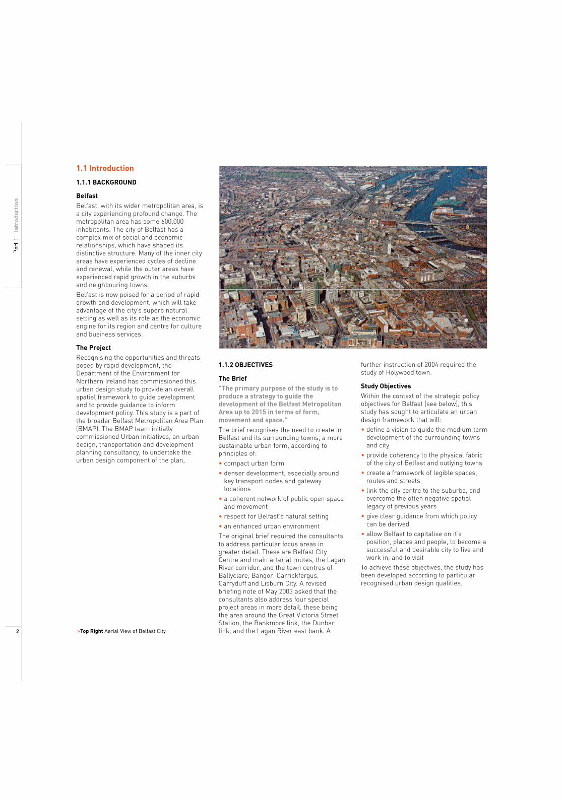
Belfast Belfast, with its wider metropolitan area, is a city experiencing profound change. The metropolitan area has some 600,000 inhabitants. The city of Belfast has a complex mix of social and economic relationships, which have shaped its distinctive structure. Many of the inner city areas have experienced cycles of decline and renewal, while the outer areas have experienced rapid growth in the suburbs and neighbouring towns. Belfast is now poised for a period of rapid growth and development, which will take advantage of the city’s superb natural setting as well as its role as the economic engine for its region and centre for culture and business services.
The Project Recognising the opportunities and threats posed by rapid development, the Department of the Environment for Northern Ireland has commissioned this urban design study to provide an overall spatial framework to guide development and to provide guidance to inform development policy. This study is a part of the broader Belfast Metropolitan Area Plan (BMAP). The BMAP team initially commissioned Urban Initiatives, an urban design, transportation and development planning consultancy, to undertake the urban design component of the plan,
>Top Right Aerial View of Belfast City
1.1.2 OBJECTIVES
The Brief "The primary purpose of the study is to produce a strategy to guide the development of the Belfast Metropolitan Area up to 2015 in terms of form, movement and space." The brief recognises the need to create in Belfast and its surrounding towns, a more sustainable urban form, according to principles of: • compact urban form
• denser development, especially around key transport nodes and gateway locations • a coherent network of public open space and movement • respect for Belfast’s natural setting • an enhanced urban environment The original brief required the consultants to address particular focus areas in greater detail. These are Belfast City Centre and main arterial routes, the Lagan River corridor, and the town centres of Ballyclare, Bangor, Carrickfergus, Carryduff and Lisburn City. A revised briefing note of May 2003 asked that the consultants also address four special project areas in more detail, these being the area around the Great Victoria Street Station, the Bankmore link, the Dunbar link, and the Lagan River east bank. A
further instruction of 2004 required the study of Holywood town.
Study Objectives Within the context of the strategic policy objectives for Belfast (see below), this study has sought to articulate an urban design framework that will: • define a vision to guide the medium term development of the surrounding towns and city • provide coherency to the physical fabric of the city of Belfast and outlying towns • create a framework of legible spaces, routes and streets • link the city centre to the suburbs, and overcome the often negative spatial legacy of previous years • give clear guidance from which policy can be derived • allow Belfast to capitalise on it’s position, places and people, to become a successful and desirable city to live and work in, and to visit To achieve these objectives, the study has been developed according to particular recognised urban design qualities.
2
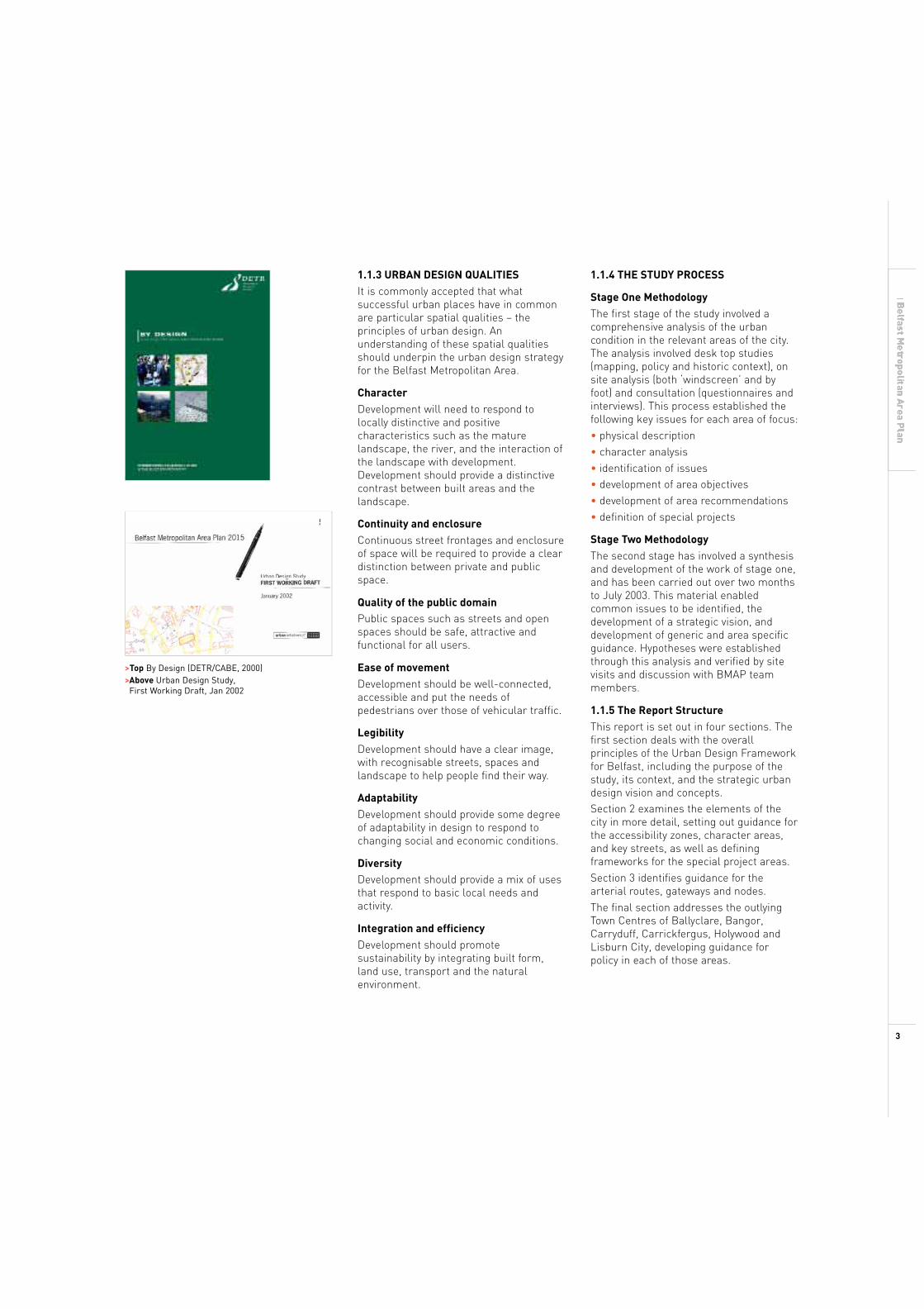
>Top By Design (DETR/CABE, 2000) >Above Urban Design Study, First Working Draft, Jan 2002
1.1.3 URBAN DESIGN QUALITIES
It is commonly accepted that what successful urban places have in common are particular spatial qualities – the principles of urban design. An understanding of these spatial qualities should underpin the urban design strategy for the Belfast Metropolitan Area.
Character Development will need to respond to locally distinctive and positive characteristics such as the mature landscape, the river, and the interaction of the landscape with development. Development should provide a distinctive contrast between built areas and the landscape.
Continuity and enclosure Continuous street frontages and enclosure of space will be required to provide a clear distinction between private and public space.
Quality of the public domain
Public spaces such as streets and open spaces should be safe, attractive and functional for all users.
Ease of movement Development should be well-connected, accessible and put the needs of pedestrians over those of vehicular traffic.
Legibility Development should have a clear image, with recognisable streets, spaces and landscape to help people find their way.
Adaptability Development should provide some degree of adaptability in design to respond to changing social and economic conditions.
Diversity Development should provide a mix of uses that respond to basic local needs and activity.
Integration and efficiency Development should promote sustainability by integrating built form, land use, transport and the natural environment.
1.1.4 THE STUDY PROCESS
Stage One Methodology The first stage of the study involved a comprehensive analysis of the urban condition in the relevant areas of the city. The analysis involved desk top studies (mapping, policy and historic context), on site analysis (both ‘windscreen’ and by foot) and consultation (questionnaires and interviews). This process established the following key issues for each area of focus: • physical description • character analysis • identification of issues • development of area objectives • development of area recommendations • definition of special projects
Stage Two Methodology The second stage has involved a synthesis and development of the work of stage one, and has been carried out over two months to July 2003. This material enabled common issues to be identified, the development of a strategic vision, and development of generic and area specific guidance. Hypotheses were established through this analysis and verified by site visits and discussion with BMAP team members.
1.1.5 The Report Structure This report is set out in four sections. The first section deals with the overall principles of the Urban Design Framework for Belfast, including the purpose of the study, its context, and the strategic urban design vision and concepts. Section 2 examines the elements of the city in more detail, setting out guidance for the accessibility zones, character areas, and key streets, as well as defining frameworks for the special project areas. Section 3 identifies guidance for the arterial routes, gateways and nodes. The final section addresses the outlying Town Centres of Ballyclare, Bangor, Carryduff, Carrickfergus, Holywood and Lisburn City, developing guidance for policy in each of those areas.
3
1.2 Context
1.2.1 STRATEGIC CONTEXT
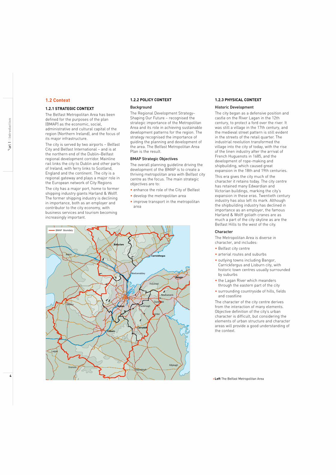
The Belfast Metropolitan Area has been defined for the purposes of the plan (BMAP) as the economic, social, administrative and cultural capital of the region (Northern Ireland), and the focus of its major infrastructure. The city is served by two airports – Belfast City and Belfast International – and is at the northern end of the Dublin–Belfast regional development corridor. Mainline rail links the city to Dublin and other parts of Ireland, with ferry links to Scotland, England and the continent. The city is a regional gateway and plays a major role in the European network of City Regions The city has a major port, home to former shipping industry giants Harland & Wolff. The former shipping industry is declining in importance, both as an employer and contributor to the city economy, with business services and tourism becoming increasingly important.
BMAP Boundary
Ballyclare
Antrim
Glenavy Belfast
Lisburn
Lurgan
Dromore
1.2.2 POLICY CONTEXT
Background The Regional Development Strategy– Shaping Our Future – recognised the strategic importance of the Metropolitan Area and its role in achieving sustainable development patterns for the region. The strategy recognised the importance of guiding the planning and development of the area. The Belfast Metropolitan Area Plan is the result.
BMAP Strategic Objectives The overall planning guideline driving the development of the BMAP is to create a thriving metropolitan area with Belfast city centre as the focus. The main strategic objectives are to: • enhance the role of the City of Belfast • develop the metropolitan area • improve transport in the metropolitan area
Carrickfergus
Newtownabbey
Bangor
Holywood
Newtownards
Dundonald
Castlereagh
Comber
Carryduff
Killyleagh
Ballynahinch
1.2.3 PHYSICAL CONTEXT
Historic Development The city began as a defensive position and castle on the River Lagan in the 12th century, to protect a ford over the river. It was still a village in the 17th century, and the medieval street pattern is still evident in the streets of the retail quarter. The industrial revolution transformed the village into the city of today, with the rise of the linen industry after the arrival of French Huguenots in 1685, and the development of rope-making and shipbuilding, which caused great expansion in the 18th and 19th centuries. This era gives the city much of the character it retains today. The city centre has retained many Edwardian and Victorian buildings, marking the city’s expansion in these eras. Twentieth century industry has also left its mark. Although the shipbuilding industry has declined in importance as an employer, the famous Harland & Wolff goliath cranes are as much a part of the city skyline as are the Belfast Hills to the west of the city.
Character The Metropolitan Area is diverse incharacter, and includes:• Belfast city centre • arterial routes and suburbs• outlying towns including Bangor,Carrickfergus and Lisburn city, withhistoric town centres usually surrounded by suburbs • the Lagan River which meandersthrough the eastern part of the city• surrounding countryside of hills, fields and coastline The character of the city centre derives from the interaction of many elements. Objective definition of the city’s urban character is difficult, but considering the elements of urban structure and character areas will provide a good understanding of the context.
>Left The Belfast Metropolitan Area 4
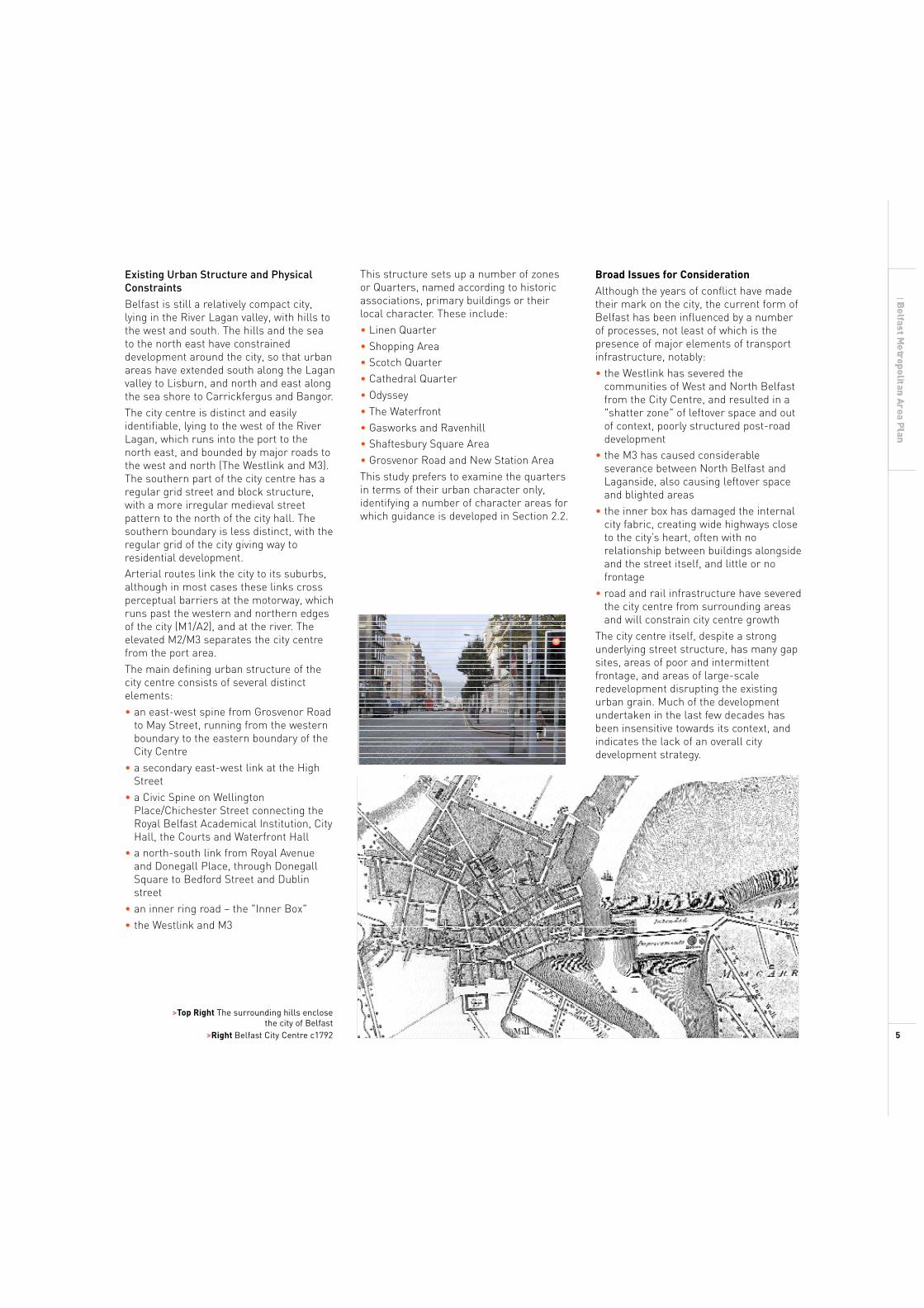
Existing Urban Structure and Physical Constraints Belfast is still a relatively compact city, lying in the River Lagan valley, with hills to the west and south. The hills and the sea to the north east have constrained development around the city, so that urban areas have extended south along the Lagan valley to Lisburn, and north and east along the sea shore to Carrickfergus and Bangor. The city centre is distinct and easily identifiable, lying to the west of the River Lagan, which runs into the port to the north east, and bounded by major roads to the west and north (The Westlink and M3). The southern part of the city centre has a regular grid street and block structure, with a more irregular medieval street pattern to the north of the city hall. The southern boundary is less distinct, with the regular grid of the city giving way to residential development. Arterial routes link the city to its suburbs, although in most cases these links cross perceptual barriers at the motorway, which runs past the western and northern edges of the city (M1/A2), and at the river. The elevated M2/M3 separates the city centre from the port area. The main defining urban structure of the city centre consists of several distinct elements: • an east-west spine from Grosvenor Road to May Street, running from the western boundary to the eastern boundary of the City Centre • a secondary east-west link at the High Street • a Civic Spine on Wellington Place/Chichester Street connecting the Royal Belfast Academical Institution, City Hall, the Courts and Waterfront Hall • a north-south link from Royal Avenue and Donegall Place, through Donegall Square to Bedford Street and Dublin street • an inner ring road – the "Inner Box" • the Westlink and M3
>Top Right The surrounding hills enclose the city of Belfast
>Right Belfast City Centre c1792
This structure sets up a number of zones or Quarters, named according to historic associations, primary buildings or their local character. These include: • Linen Quarter • Shopping Area • Scotch Quarter • Cathedral Quarter • Odyssey • The Waterfront • Gasworks and Ravenhill • Shaftesbury Square Area • Grosvenor Road and New Station Area This study prefers to examine the quarters in terms of their urban character only, identifying a number of character areas for which guidance is developed in Section 2.2.
Broad Issues for Consideration
Although the years of conflict have made their mark on the city, the current form of Belfast has been influenced by a number of processes, not least of which is the presence of major elements of transport infrastructure, notably: • the Westlink has severed the communities of West and North Belfast from the City Centre, and resulted in a "shatter zone" of leftover space and out of context, poorly structured post-road development • the M3 has caused considerable severance between North Belfast and Laganside, also causing leftover space and blighted areas • the inner box has damaged the internal city fabric, creating wide highways close to the city’s heart, often with no relationship between buildings alongside and the street itself, and little or no frontage • road and rail infrastructure have severed the city centre from surrounding areas and will constrain city centre growth The city centre itself, despite a strong underlying street structure, has many gap sites, areas of poor and intermittent frontage, and areas of large-scale redevelopment disrupting the existing urban grain. Much of the development undertaken in the last few decades has been insensitive towards its context, and indicates the lack of an overall city development strategy.
5
1.2.4 CONCURRENT STUDIES
This study needs to be considered alongside a number of concurrent studies, including the following:
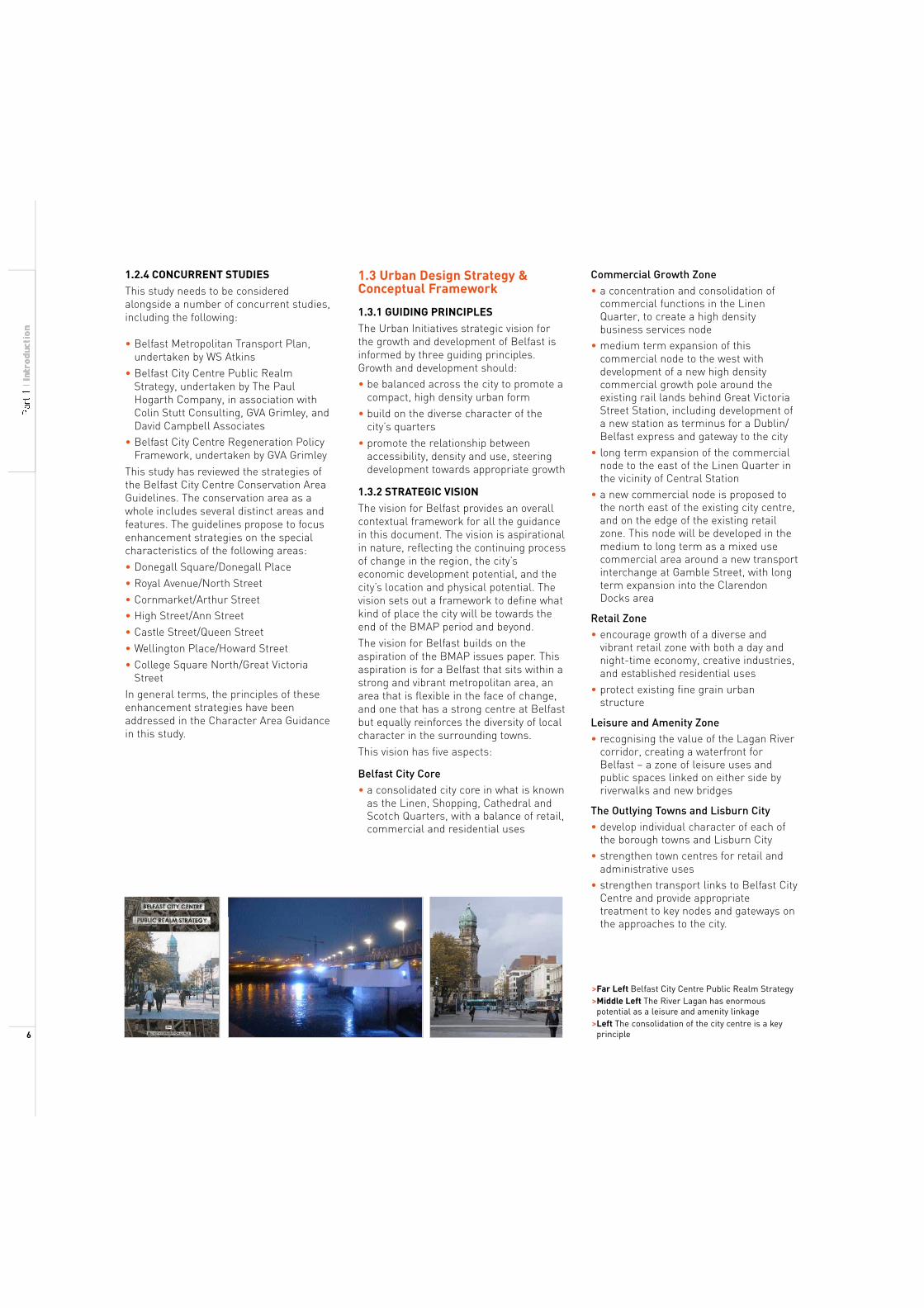
• Belfast Metropolitan Transport Plan, undertaken by WS Atkins • Belfast City Centre Public Realm Strategy, undertaken by The Paul Hogarth Company, in association with Colin Stutt Consulting, GVA Grimley, and David Campbell Associates • Belfast City Centre Regeneration Policy Framework, undertaken by GVA Grimley This study has reviewed the strategies of the Belfast City Centre Conservation Area Guidelines. The conservation area as a whole includes several distinct areas and features. The guidelines propose to focus enhancement strategies on the special characteristics of the following areas: • Donegall Square/Donegall Place • Royal Avenue/North Street • Cornmarket/Arthur Street • High Street/Ann Street • Castle Street/Queen Street • Wellington Place/Howard Street • College Square North/Great Victoria Street In general terms, the principles of these enhancement strategies have been addressed in the Character Area Guidance in this study.
1.3 Urban Design Strategy & Conceptual Framework
1.3.1 GUIDING PRINCIPLES
The Urban Initiatives strategic vision for the growth and development of Belfast is informed by three guiding principles. Growth and development should: • be balanced across the city to promote a compact, high density urban form
• build on the diverse character of the city’s quarters • promote the relationship between accessibility, density and use, steering development towards appropriate growth
1.3.2 STRATEGIC VISION
The vision for Belfast provides an overall contextual framework for all the guidance in this document. The vision is aspirational in nature, reflecting the continuing process of change in the region, the city’s economic development potential, and the city’s location and physical potential. The vision sets out a framework to define what kind of place the city will be towards the end of the BMAP period and beyond. The vision for Belfast builds on the aspiration of the BMAP issues paper. This aspiration is for a Belfast that sits within a strong and vibrant metropolitan area, an area that is flexible in the face of change, and one that has a strong centre at Belfast but equally reinforces the diversity of local character in the surrounding towns. This vision has five aspects:
Belfast City Core • a consolidated city core in what is known as the Linen, Shopping, Cathedral and Scotch Quarters, with a balance of retail, commercial and residential uses
Commercial Growth Zone • a concentration and consolidation of commercial functions in the Linen Quarter, to create a high density business services node • medium term expansion of this commercial node to the west with development of a new high density commercial growth pole around the existing rail lands behind Great Victoria Street Station, including development of a new station as terminus for a Dublin/ Belfast express and gateway to the city • long term expansion of the commercial node to the east of the Linen Quarter in the vicinity of Central Station • a new commercial node is proposed to the north east of the existing city centre, and on the edge of the existing retail zone. This node will be developed in the medium to long term as a mixed use commercial area around a new transport interchange at Gamble Street, with long term expansion into the Clarendon Docks area
Retail Zone • encourage growth of a diverse and vibrant retail zone with both a day and night-time economy, creative industries, and established residential uses • protect existing fine grain urban structure
Leisure and Amenity Zone • recognising the value of the Lagan River corridor, creating a waterfront for Belfast – a zone of leisure uses and public spaces linked on either side by riverwalks and new bridges
The Outlying Towns and Lisburn City • develop individual character of each of the borough towns and Lisburn City • strengthen town centres for retail and administrative uses • strengthen transport links to Belfast City Centre and provide appropriate treatment to key nodes and gateways on the approaches to the city.
>Far Left Belfast City Centre Public Realm Strategy >Middle Left The River Lagan has enormous potential as a leisure and amenity linkage >Left The consolidation of the city centre is a key principle 6
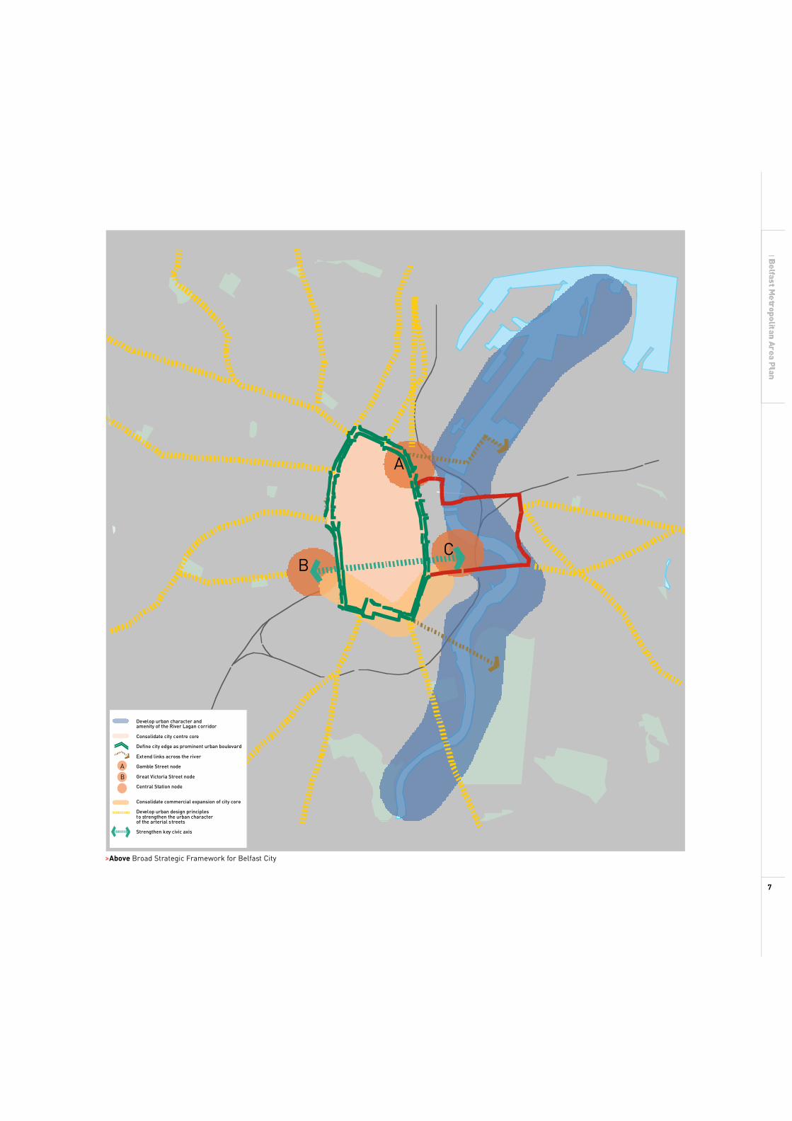
C
A
C B
Develop urban character and amenity of the River Lagan corridor
Consolidate city centre core
Define city edge as prominent urban boulevard
Extend links across the river
A Gamble Street node
B Great Victoria Street node
Central Station node
Consolidate commercial expansion of city core
Develop urban design principles to strengthen the urban character of the arterial streets
Strengthen key civic axis
>Above Broad Strategic Framework for Belfast City
7
1.3.3 THE CITY CENTRE – KEY CONCEPTS
This urban design strategy for Belfast considers the city and the key outlying towns and Lisburn City separately. Different factors are involved, and the issues in the city are generally more complex than those in the outlying towns. The urban design strategy and guidance for the city centre is developed around 6 key concepts, which concern the definition of areas for high density development, articulation of areas of particular character through the city, and the definition of particular streets through the city.
High Accessibility/High Density Development Zones Sustainable growth and expansion of the city centre is dependent on a close relationship between land use and transport. Increasing accessibility for new development will require major new public transport initiatives. Three potential high accessibility zones, providing opportunities for greater development density and larger building scale, are identified: • the development of a new high profile terminus station serving the heart of the city at the Grosvenor Road/Boyne Bridge interchange (to replace the existing Great Victoria Street Station), will provide a major development opportunity at the station site as well as enhancing the accessibility of the city centre • the existing Central Station will be retained to serve the city centre east, and the long term expansion area south of East Bridge Street, as well as future east-bank development at the former Sirocco Works site. A high quality shuttle transit between the two stations will link both to the City Hall • development of a new bus station at Gamble Street, with potential for interchange with a future rail station, provides a focus for a high density development at the northern edge of the city at the interface of the Clarendon Docks and the Cathedral Quarter To facilitate the development potential of these three development zones, this study proposes that a new intermediate mode of transit is developed to link each of these to one another, to the city airport, and to the surrounding suburbs.
Character Areas A number of different character areas are identified in the city relating to their existing character and uses, and their potential to accommodate change. Definition of these character areas is loosely based on the City Quarters identified in section 1.2.3. Each will have a set of blanket guidelines designed to reinforce the character aspired to in the particular area. These areas provide the basis for developing a variety of places in the city, with diversity in activities and urban form.
The City Centre Ring The development of the inner ring road, or Inner Box, has left a scar on the fabric of the city centre.The legacy of major road construction is a series of disjointed and truncated streets, weak corners, and expansive road areas. Addressing this legacy is a priority, but rather than seeing this as a problem to be solved, it can be viewed as a significant urban design opportunity. It is proposed to develop the Inner Box as a boulevard or avenue circling the existing city centre. It should be conceived and designed as an orbital boulevard, grand in scale and with generous proportions, a consistent approach to streetscape design, strong built street edges, and linear definition through a distinctive landscape structure of close set lines of trees. The relationship between carriageway, footpath, tree line and building, will be crucial. This structure will define the limits of the existing city centre, identifying it as a cohesive place, yet at the same time knit together new and existing development on the city centre fringes.
The Civic Spine A single, direct street connects the main civic uses of the city. Starting in the west with Wellington Place at the Royal Belfast Academical Institution, the street runs east along Donegall Square North past the City Hall, becoming Chichester Street which leads past the courts to the Waterfront Hall. This is an important structural element in the city centre and the importance of the route should be reflected in a consistent approach to the treatment of public realm and built form.
The Belfast Cross Belfast originally developed westwards from the Lagan River, and the original High Street still runs west from the waterfront into the heart of the shopping quarter, where it intersects with what is now the principal retail street – Donegall Place and Royal Avenue. This crossing forms the hub of the ‘Belfast Cross’, two intersecting primary pedestrian routes that are extended to link through the city from north to south, and from east to west.
Arterial Streets The city centre is linked to the suburbs by a number of radiating arterial routes. However, in many cases, the link between the arterial route and the city centre has been shattered. Understanding the strategic nature of these routes is crucial to ensuring an appropriate approach to development. Although these streets are the major transport connections between the city and the suburbs, they have in many cases retained their historic function as local high streets, rather than been restructured as transport corridors. These routes also have important symbolic functions. Many of them, such as Shankill, Crumlin and Falls Roads, have developed as boundaries between different communities, or as the identified territory of one or the other. They also act as significant notional connectors of the opposite ends of the city, through the city centre. The approach to development of the public realm and private domain should reinforce the role of these routes as links between residential communities and the heart of the city. In addition, special consideration is needed for the treatment of nodes and gateways. ‘Nodes’ form points of local activity along the arterial routes. ‘Gateways’ mark the entrance to the city.
8
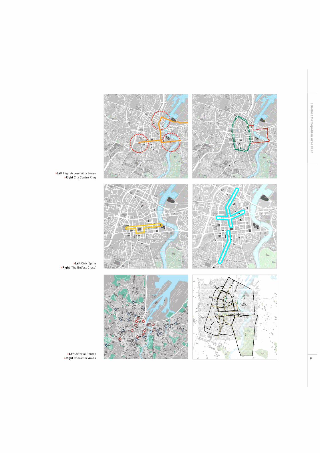
>Left High Accessibility Zones >Right City Centre Ring
>Left Civic Spine>Right ‘The Belfast Cross’
N2
N5 N1
N4
N3G2 N6
N7 G1
G3
G11 G12 N15 N16
N17
G5 G4 G10 N13 G9
N8 N18
G8 N14
N12 G7 N11
N10G6
N9
>Left Arterial Routes>Right Character Areas 9
1.4 Aspects of Building Height
Building Height Building height in cities can be expressed in terms of the number of storeys or as Building Shoulder Height (BSH). BSH is the sheer height of the front façade on the building line, and often acts as the linking element in street frontage. Additional storeys on top of the BSH may be setback (within a clearly defined range of maximum building heights) where it can be demonstrated that there will be no consequential negative impact on the street. This allows for a variation in the top level or ridgeline of the building. This implies that residential and hotel buildings can have higher top floors with the introduction of mezzanines (for pent houses or studios) in return for mansard roofs and/or larger setbacks from the building line.
Continuous Building Height Line In some streets, a continuous building shoulder height line or ridgeline is evident. This form of development often occurs along formal streets, for example, Royal Avenue and Chicester Street.
Varied Building Height line In other streets, the height of building often varies, responding to local and changing conditions. These height variations create different street characters, which animate views of the street silhouette and city skyline. New building should respond to this character where it exists.
Landmarks Landmarks are often taller buildings which cut through the skyline and act as key markers in the city. These structures can assist legibility and mark the distinctiveness of special places. In this respect, there are two key aspects to building height. On the one hand, building height should contribute to the strengthening of the city fabric. On the other hand, opportunities for the development of special marker buildings should be explored.
Principles for determining Building Height A review of examples in the UK suggests that building height policy should: • protect the city image by requiring buildings to respect the city topography • identify a general scale of building appropriate to the city and require
buildings to be generally consistent with this scale • protect existing landmarks, strategic views and settings, rooflines and conservation areas • protect the visual ‘backcloth’ or views to the surrounding landscape • outline locational and design criteria for new high buildings
Building Height Criteria for Belfast City Centre Four key design criteria should be considered: • Character Areas Belfast City Centre has a number of areas of different character. It is the variety of these areas that give Belfast City its special quality. One aspect of this urban quality is building height. Sections 2.2 and 2.3 of this report outlineguidance to reinforce area character.• Nature of route The scale of city streets in Belfast varies. Some of the key streets are wide, enclosed on either side by tall buildings. In other areas, public spaces and parks provide opportunities for taller buildings. The scale of building height therefore should be related to the scale of thespace it encloses.• Adjacent buildings The height of adjacent buildings provide contextual clues for new development. The key criteria for relating new buildings to existing stock is to identify the linking element, for example, Building Shoulder Height, parapet height etc and respect these cues. The use of setback top storeys may be promoted, where there is no impact on the continuity of the dominant building lines.
• The qualities we want to achieve in city streets and spaces A key consideration in determining building height is to identify the qualities we want to achieve in the city streets and spaces. For example, on many of the key streets, a vibrant, mixed use culture is generally promoted, enlivened by outdoor cafes and dining areas. To achieve these objectives, the street needs to be attractive and welcoming, with an appropriate micro climate. In this regard, the extent of sun penetration into the street is a key consideration. As a general principle, and acknowledging the pattern of the seasons, it should be an objective to get sun into these key streets for at least two thirds of the year, and especially around lunchtime hours. BRE ‘Site Layout Planning for Daylight’ and BS 8206 Part 2 :Code of Practice for Daylight set out established methods for predicting the amount of sunshine by location. The details in these publications can be tested against street sections to identify the extent of potential sun penetration at different times of the year (see opposite.) In this context, a range of roof forms and top storey setback options can be tested to identify building forms and heights that achieve the required amount of sun penetration. For new development in the city, developers should apply these methods to illustrate how the new development will achieve the urban design qualities promoted by the City, particularly where a maximum building height condition is proposed.
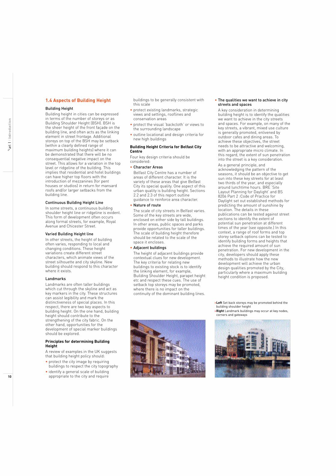
>Left Set back storeys may be promoted behind the building shoulder height >Right Landmark buildings may occur at key nodes, corners and gateways
10
Methodology
• Specify minimum and maximum building height. A minimum building height is proposed for each of the character areas (See Guidance in Sections 2.2 and 2.3) and key streets (See Guidance in Sections 2.4 and 2.5). This minimum height will set up the basic street structure in terms of scale and enclosure, and generally respond to existing development. Maximum building height expresses the maximum height which will be considered where the developer can demonstrate that:
- the proposed height is in line with the urban design guidance and contributes to the urban character of the area or street.
- the proposed building does not result in any negative impacts on adjoining buildings, streets, blocks or views.
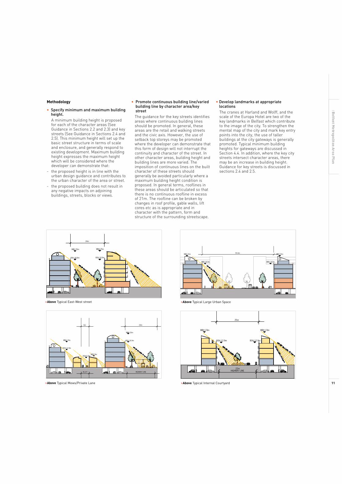
24m
MBH 25m MBH 25m
BSH 18.9m BSH 18.9m
>Above Typical East-West street
6m
• Promote continuous building line/varied building line by character area/key street The guidance for the key streets identifies areas where continuous building lines should be promoted. In general, these areas are the retail and walking streets and the civic axis. However, the use of setback top storeys may be promoted where the developer can demonstrate that this form of design will not interrupt the continuity and character of the street. In other character areas, building height and building lines are more varied. The imposition of continuous lines on the built character of these streets should generally be avoided particularly where a maximum building height condition is proposed. In general terms, rooflines in these areas should be articulated so that there is no continuous roofline in excess of 21m. The roofline can be broken by changes in roof profile, gable walls, lift cores etc as is appropriate and in character with the pattern, form and structure of the surrounding streetscape.
MBH 25m
MBH 18.9m
• Develop landmarks at appropriate locations The cranes at Harland and Wolff, and the scale of the Europa Hotel are two of the key landmarks in Belfast which contribute to the image of the city. To strengthen the mental map of the city and mark key entry points into the city, the use of taller buildings at the city gateways is generally promoted. Typical minimum building heights for gateways are discussed in Section 4.4. In addition, where the key city streets intersect character areas, there may be an increase in building height. Guidance for key streets is discussed in sections 2.4 and 2.5.
55.6m MBH 25m
MBH 18.9m
>Above Typical Large Urban Space
25m
24m
MBH 19m MBH 19m MBH 25m
MBH 19m BSH 18.9m BSH 12.9m BSH 12.9m
BSH 12.9m
MBH 8mBSH 6.9m
22m HIGHWAY LINE
ALLEY HIGHWAY LINE
>Above Typical Mews/Private Lane >Above Typical Internal Courtyard 11