Embed Size (px)
Citation preview

Belle Isle State Park 1632 Belle Isle Road Lancaster, VA 22503
BELLE ISLE STATE PARK MASTER PLAN
EXECUTIVE SUMMARY 2017 UPDATE
Department of Conservation and Recreation Division of Planning and Recreation Resources
600 East Main Street, 24th Floor Richmond, Virginia 23219

Belle Isle State Park 2017 Executive Summary July 21, 2017
BELLE ISLE STATE PARK MASTER PLAN
EXECUTIVE SUMMARY 2017 UPDATE
Presented for review at a public meeting on September 29, 2016, then recommended for adoption by the Board of Conservation and Recreation on January 27, 2017, and then reviewed for 30 days by
the Virginia General Assembly.
Adopted: ___________/S/_______________________ July 21, 2017 Clyde E. Cristman, Director Date Department of Conservation and Recreation

Belle Isle State Park 2017 Executive Summary i July 21, 2017
BELLE ISLE STATE PARK
MASTER PLAN EXECUTIVE SUMMARY
2017 UPDATE Park Purpose Statement “The purpose of Belle Isle State Park is to serve as a Gateway to the Rappahannock River and the transition from river to the Chesapeake Bay by providing a range of family-oriented outdoor recreation and educational experiences, which identify and interpret the historical connections of various ages with visual and physical connections to the land and water and provide for estuarine research opportunities.” Introduction The Belle Isle State Park Master Plan was originally adopted October 29, 1998, by Department of Conservation and Recreation (DCR) Director David G. Brickley. The plan was renewed on December 16, 2004, by the DCR Director Joseph H. Maroon, and then on March 18, 2011, DCR Director, David A. Johnson approved an updated plan. The 2017 executive summary represents the most recent ten-year review as described in §10.1-200.1 of the Code of Virginia. It outlines the desired future condition for Belle Isle State Park when it is fully developed. Belle Isle State Park is located on the northern shore of the Rappahannock River in Lancaster County, which is in the Northern Neck Planning District (Region 17) of eastern Virginia. The park is accessed via Route 683 off Route 354. It is about 70 miles northeast of Richmond, 80 miles southeast of Fredericksburg and 70 miles from the Hampton Roads area. Comprising 889.85 acres, with frontage on the Rappahannock River and Deep and Mulberry Creeks, the initial purchase was made in April 1993 with funds appropriated from the 1992 Virginia Park and Recreation Facilities Bond Act. The Department of Conservation and Recreation (DCR) retained EDAW, Inc. to create the original park plan, and Belle Isle development was started in 1993. In 1998, the master plan was and modified to adjust for changing conditions, new acquisitions and development. All park amenities funded through the 1992 Virginia Park and Recreation Facilities Bond Act were completed by the fall 1999, when the park opened to visitors. From the original acquisition of 674.9 acres in 1993 to the most recent in 2015, the park has added 215 acres from 5 parcels. The site has significant cultural value dating back to the 1750s. The property was listed on the National Register of Historic Places in 1973. This master plan executive summary includes information from the park’s resource management plan and visitor experience plan, as well as information on park revenues and economic activity. This information guides the future of the park’s development and management.
Belle Isle State Park 2017 Executive Summary ii July 21, 2017
Resource Management Plan The resource management plan consolidates all known resource information for a park and provides management direction for maintaining and enhancing those resources. The plans identify the physical, abiotic, and biotic characteristics of the park, and historic and archaeological resources, as well as a description of the legal constraints and limitations. The park is delineated into undeveloped areas based on the ecosystems found in these areas; unique management areas which are undeveloped areas with a specific purpose or function such as a historic battlefield or open field; and developed areas where park facilities are located yet have natural and cultural resources requiring specific management. The plan has defined management objectives and action recommendations that guide resource management and allow for continuity over time. Located in the Coastal Plain physiographic region, the park forms a peninsula bordered by the Rappahannock River, Mulberry Creek and Deep Creek, with a combined water frontage of more than 9 miles. Natural ecosystems existing at the park include mesic mixed hardwood forest, Central Atlantic coastal plain maritime forest, and various wetland ecosystems including freshwater forested/scrub wetlands, tidal marsh, and estuarine and marine wetlands. There are eight separate early successional grassland fields that are managed through prescribed burning. These fields total 37 acres and are managed to maintain an open area of warm season grasses and forbs planted to support a variety of native wildlife, pollinator and bird species.
Bald eagle nests also exist at the park. Park staff manage the nests to protect them from disturbances according to state recommended guidelines. Several non-native invasive species exist at the park including phragmites, Johnson grass, Chinese lespedeza, Chinese privet, multiflora rose, ailanthus and autumn olive. An invasive species management program has existed at the park for several years in which these species are treated annually to help control the spread. Managed deer hunts have been utilized to reduce the deer population to prevent damage to the park’s natural resources and existing farm fields which are leased. One hundred thirty-four acres of park land are leased for agriculture. Crops include soybeans, barley, rye, corn and wheat.
The park land was originally owned by John Bertrand, a Huguenot, in 1692. There are numerous archaeological sites on the property as well as historic structures. It is believed that the main portion of the Belle Isle Plantation House was built prior to 1759 by William Bertrand, John Bertrand’s son. Support buildings including a kitchen were constructed around 1760. The property was sold in 1786 to the Downman family who expanded the mansion and maintained ownership of Belle Isle until 1918. The Pollard and Boatwright (brother and sister) families owned all of the Belle Isle property beginning in 1939. The Boatwright’s kept the Belle Isle mansion and most of the farming acreage. The Pollard family retained about 35 acres and built a revived colonial home (Bel Air). The Boatwright parcel was sold to the Gruis’s and Gillette’s in 1977. In 1987, around 700 acres of the property was sold to Jimmy Carter/Bay Trust Company (real estate developer). The Gruis’s kept the Belle Isle mansion and 152 acres. The 700 acres was divided into 65 waterfront lots with septic approved for the subdivision. The Commonwealth purchased the 700 acres in 1993 to become Belle Isle State Park. The Pollard parcel was purchased by Davis Hamlin in

Belle Isle State Park 2017 Executive Summary iii July 21, 2017
1987 and then sold to the Commonwealth in 1994. Deemed an excellent example of a small Tidewater plantation complex in the historic register nomination, Belle Isle was listed in 1973 on the National Register of Historic Places for its architectural significance. Visitor Experience Plan The visitor experience management plan provides a park-wide vision for the future of interpretation, education, recreation and other visitor experience opportunities. The plan addresses all elements of a park that affect visitor experiences, including personal services, media, facilities and landscapes. It is a conceptual document that lays a foundation for subsequent phases of comprehensive interpretive planning: facility and media planning, design and production; and organization of staff and activities into annual visitor experience implementation plans. A primary theme encompasses the overall park story. It is the single most important message ALL park guests should receive and remember. Secondary themes are important messages related to the primary theme that should be presented to park guests. Any other sub-themes and topics that may be interpreted at the park should be linked to these secondary themes. Planning workshops were held in late 2009 and early 2010, and information was compiled by park staff, Friends’ members and representatives of various user groups. A formal Visitor Experience Plan was created for use by park staff, planners, and designers in 2010. This was one of the first Visitor Experience Plans created for Virginia State Parks. Interpretive themes for Belle Isle State Park were developed during the visitor experience planning workshops. Primary theme – From ancient times until the present, the water, landscapes and natural assets of Belle Isle have been an important agricultural, economic and recreational resource for people and a healthy habitat for diverse animal and plant species. Secondary themes - Belle Isle State Park’s secondary themes focused on three areas: History - People from pre-colonial times to the present have used the Rappahannock River and surrounding landscape resources to survive and thrive. A wealth of opportunities for settlement, agriculture, and commerce has created a distinct lower Northern Neck cultural heritage. Recreation - Belle Isle State Park provides access to forest, fields, river, creeks and wetlands for family-oriented active recreation or quiet contemplation. Nature - The quiet, secluded setting of Belle Isle State Park is a natural oasis that provides refuge for an abundant variety of plants and animals in an easily accessible area for people to observe, study and appreciate the value of nature conservation.

Belle Isle State Park 2017 Executive Summary iv July 21, 2017
Park Master Plan The Department of Conservation and Recreation Planners and State Park Staff conducted this master plan update in accordance with §10.1-200.1 of the Code of Virginia. As required by the Code of Virginia, it must be revisited every ten years to ensure that the development objectives outlined in the plan continue to meet the recreational and conservation needs of the citizens of the Commonwealth. This plan outlines the desired future condition of the park over a 30-year planning horizon. As a part of the 2017 master plan process, the original 1998 plan and the 2004 and 2011 park master plan updates were reviewed. Planning staff met with park staff and conducted a site visit to gather information for this plan update. A public meeting was held on September 29, 2016, to share the draft plan and receive public comment. Following the public meeting, the phased development plan and estimated costs were revised, as were the staffing and operational costs for the park for each phase of development. The final draft of the executive summary and map were developed. This plan outlines the desired future condition of the park during a 30-year planning horizon. The draft 2017 executive summary and map were presented to the Board of Conservation and Recreation at their January 27, 2017, meeting and were recommended for adoption. The documents were then placed on the DCR website for a 30-day review by the Virginia General Assembly. Following that review, the updated plan was presented to the DCR Director Clyde E. Cristman for adoption. Following adoption, the updated executive summary and map were placed online http://www.dcr.virginia.gov/recreational-planning/masterplans for the public to access. Attendance, Economic Impact and Park Revenues Annual visitation to the park has generally increased over the last 10 years as depicted in the following table:
Park Visitation – Belle Isle (Calendar Year¹)
2006 2007 2008 2009 2010 2011 2012 2013 2014 2015 31,818 43,051 38,032 37,389 39,947 43,855 41,326 42,742 48,067 44,502
¹Note that the calendar year ends 6 months after the fiscal year. In 2015 Belle Isle had 44,502 visits; 12,829 were overnight visits, while 31,673 were day use visits.

Belle Isle State Park 2017 Executive Summary v July 21, 2017
Economic activity is created by the park from three sources: Park visitation, the park operating budget (but only to the extent that it was not funded by park visitor revenues in order to avoid double counting), and park construction projects. The following table summarizes this economic activity for 2015:
Total Economic Activity including Visitation, Park Budget, and Construction
(Adjusted to local economy) Visitor Spending
Spending on Park Budget (excluding portion derived from visitation)
Spending on Park Construction
State and Local Taxes Created
Dollars Jobs Dollars Dollars Dollars Dollars
$ 1,723,613 20.9 $ 1,137,428 $ 253,521 $ 13,428 $ 117,201
In general, overnight visitors create the greatest amount of economic activity, and at this park, overnight visitors account for about 60% of visitor spending activity despite the absence of traditional park cabins. (The park has two vacation homes that rent to the public.) A majority of the 20.9 jobs that are created by the park’s economic activity are local jobs that benefit the local rural community. This park generates state and local taxes that cover a major portion of the park budget that is not derived from visitor revenues. Master plan recommendations designed to increase visitation and improve the visitor experience, once implemented, should have a further positive impact on the community’s economic vitality. The following chart depicts revenue generated at the park from fiscal year 2008 to 2016:
Park Revenues - Belle Isle
2008 2009 2010 2011 2012 2013 2014 2015 2016
$132,995 $135,621 $160,127 $195,119 $174,967 $172,188 $209,105 $212,504 $217,951
In FY 2016, Virginia State Parks generated $21,233,340 in total revenue-- $11,138,230 from overnight facilities and $10,095,110 from other sources. Belle Isle State Park contributed $217,951 to the revenue total, $128,904 in overnight revenue and $89,047 from other sources. Revenue generated by Virginia State Parks is reinvested in the state park system to maintain and operate the parks. In FY 2016, 48% of the state park budget came from revenues generated in the parks.
Belle Isle State Park 2017 Executive Summary vi July 21, 2017
Existing Facilities Contact station Visitor Center Park Office Amphitheater Concession with comfort station Boat ramp and car top launch area Fishing pier and platform Picnic areas with shelters (2) and comfort station Playground Boat and bike rental facilities 9.5 miles of trails Parking for horse trailers Historic rental houses (2) Staff residences (4) with one across Mulberry Creek. Campground (30 sites) with Bathhouse Group Camp Camp store YCC Bunkhouse Maintenance Shop Canoe/Kayak campsites (4) Bel Air Mansion (overnight – sleeps 6) Bel Air Guest House (overnight- sleeps 8) Belle Isle Plantation House with historic landscape and support structures (to be restored) Park infrastructure: Roads, water system, waste water system, and utilities. Connectivity This 2017 update places value on connecting Belle Isle to other resources in the community. Water resources are abundant: in addition to the Rappahannock River, Mulberry Creek and Deep Creek which serve as park boundaries, there are many smaller tributaries in close proximity to the park, along with the unrivaled Chesapeake Bay. Water trails have been mapped on many river tributaries. Conservation areas with hiking trails nearby include Rappahannock River Valley National Wildlife Refuge, Chilton Woods State Forest and Hickory Hollow and Bush Mill Stream Natural Area Preserves.
A short drive leads to the Morattico Waterfront Museum, the Mary Ball Washington Museum and Library, Richmond County Museum and Visitor Center or Rice’s Hall/Hughlett’s Tavern. Belle Isle State Park is listed as a site on the Department of Game and Inland Fisheries’ Birding and Wildlife Trail, the Virginia Oyster Trail and the Captain John Smith Chesapeake National Historic Trail. Scenic Roads in the area include portions of State Highways 354 and 604. The Rappahannock and Corrotoman Rivers as well as Cat Point Creek are designated scenic rivers. The Belle Isle State Park Regional Connectivity Map is an attachment to the full Master Plan document.

Belle Isle State Park 2017 Executive Summary vii July 21, 2017
TheVirginiaOutdoorPlan(VOP)identifieslandconservationandoutdoorrecreationresources.TheVOPMapperhttp://www.dcr.virginia.gov/recreational‐planning/vopmapperidentifiestheseresourcesbothwithinandaroundstateparkstoencouragecrosspromotion,physicallinksandothercollaborativeefforts.Themapperisupdatedonanannualbasis. Land and Water Conservation Fund Belle Isle State Park received Federal Land and Water Conservation Funds (LWCF) in 2005 for park facility development. In compliance with the LWCF Act of 1965 and amendments thereto, the Commonwealth of Virginia is required to maintain the park for public outdoor recreation in perpetuity. Americans with Disabilities Act (ADA) Virginia State Parks strive to meet the requirements of the Americans with Disabilities Act (ADA) Standards. Land Acquisition/Viewshed Protection Additional land acquisition is recommended to enhance park offerings, establish connective trail easements/corridors, buffer the park from inappropriate development and/or protect valued viewsheds. Future land acquisitions will only be negotiated with willing property owners. The placement of conservation easements on adjacent property to preserve the natural resources, cultural landscapes, and scenic resources in close proximity to the park will be encouraged. In working cooperatively with neighboring landowners, the park will be enhanced and protected over time. Environmental/Design Guidance This 2017 master plan update describes both proposed facilities and improvements to existing facilities. New facilities are sited to minimize impact to the park, and in keeping with the prescriptive management areas as defined by the Park Resource Management Plan and the guidelines of the Park Visitor Experience Plan, when available. New facilities at this park should be designed and built with consideration to the original design and layout of facilities. These facilities will be carefully sited to minimize impacts to the views in the park and of the park from adjacent lands and water bodies. Consideration will be given to eliminate excessive, misdirected or obtrusive artificial light in the park in order to maximize the dark sky effect and encourage astronomy and night-sky viewing. Building and site design will implement green energy standards using energy-efficient and sustainable materials and procedures to the greatest extent possible. Green design initiatives will be considered during the design process for park renovations and new construction. Development activities will comply with requirements set forth by the Department of Environmental Quality’s best management practices for erosion, sediment control and stormwater management in order to protect water quality. A setback guideline of 100 feet from the shoreline has been established by
Belle Isle State Park 2017 Executive Summary viii July 21, 2017
DCR, and trails and water-dependent facilities such as fishing stations, piers and other water access facilities will be the only developments permitted within the 100-foot setback. There are potential challenges of overuse and crowded conditions, which may require management actions to protect the resources and the quality of the park experience. Issues related to resource carrying capacity and social carrying capacity should be evaluated prior to developing new facilities. Special Issue: Impacts from Storm Surge and Sea Level Rise Recurrent flooding is a threat to state parks in low lying coastal areas including the Chesapeake Bay, Albemarle-Pamlico Sound and their tidal tributaries. Some low-lying areas will have more frequent flooding, and very low-lying land could be submerged completely. Recurrent flooding can also harm important coastal ecosystems and cause additional shoreline erosion. Sea level rise and storm surge are important factors to consider when designing, locating and constructing new facilities, and in the decision to renovate existing facilities. The data used for mapping is based on information provided by the Virginia Institute of Marine Science (VIMS) and assumes a 1.5 foot rise in sea level and a 4.5 foot storm surge in the next 30 to 50 years. Based on these projections, the master plan map indicates flooded areas within the park boundaries. Phased Development Plan Proposed developments for the park are presented in priority order. Completion of all of the projects in this list will represent total build-out (completion of the master plan), and cover a 30-year timeframe. The phasing costs are based on 2017 cost estimates. Shoreline stabilization and the dredging of Deep Creek will be an ongoing issue, and long term planning and funding will be needed to protect the recreational resources of Belle Isle State Park. Phase I Renovate Belle Isle Plantation House, out-buildings and historic landscape Upgrade fuel station in maintenance area Shoreline stabilization at visitor center, day-use, Watch House and Bel Air Guest House sites Dredge Deep Creek to boat ramp Develop interpretive exhibits for the Visitor Center Construct a 30-site campground, including 4 yurts/camping cabins with bathhouse Provide additional parking for picnic area (60 spaces) Construct screened-in shelter at YCC bunkhouse with water and electric Construct and develop a trail with a bridge across the Mulberry Creek inlet Construct staff residences (2) Demolish garage at Belle Isle Plantation House site The total estimated cost for Phase I development is $18,758,844

Belle Isle State Park 2017 Executive Summary ix July 21, 2017
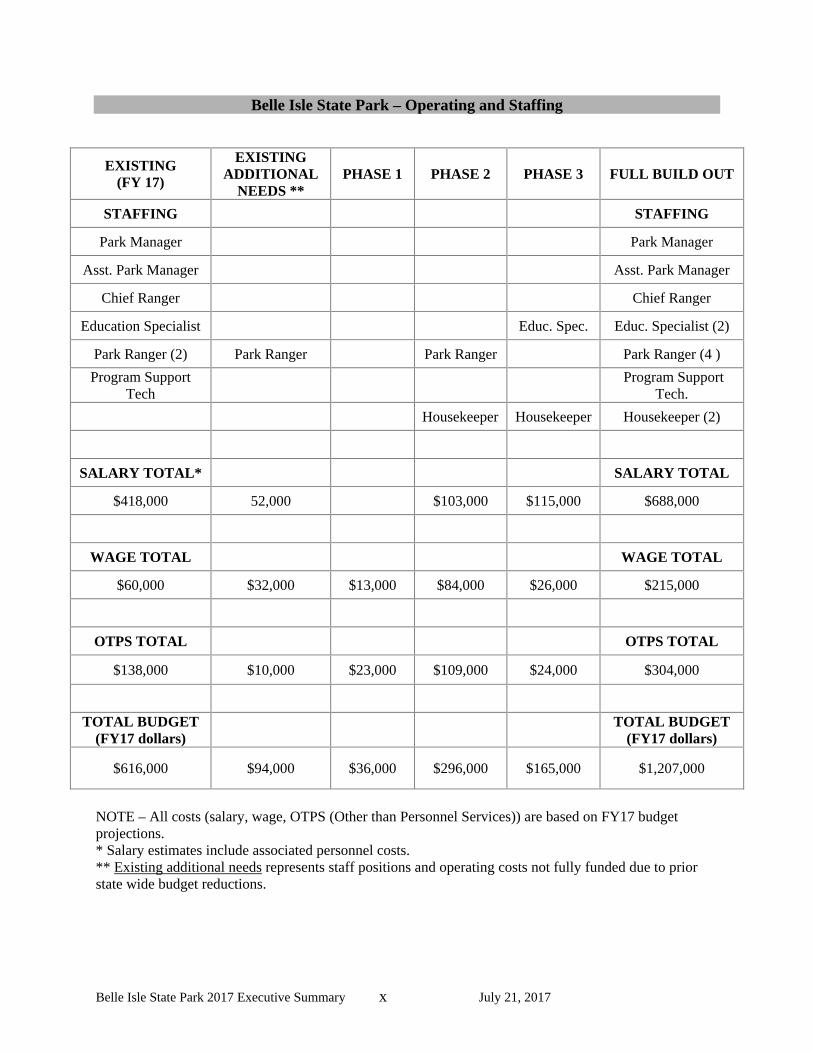
Phase II Construct a fishing pier (200 foot) in the day-use area Cabins (12) with boat tie-ups Construct a day-use boat tie-up adjacent to the large boat ramp Staff residence Renovate three existing staff residences for overnight rentals Construct a meeting facility with seating for 150-200, kitchen, conference room, comfort station The total estimated cost for Phase I development is $12,258,921 Phase III Restore historic barn for interpretive programs Construct a comfort station and canoe storage at the car-top launch Upgrade group camp with water, electric, bathhouse, shelter, gravel road and parking (20 spaces) Construct a water feature/spray ground in the day-use area The total estimated cost for Phase I development is $4,840,652 The total cost to bring Belle Isle State Park to its desired future condition is $35,858,616 Staffing and Operations Staffing and operational costs at Belle Isle State Park are presently budgeted at $616,000 annually, including salaries for seven staff positions. With the current facilities and operational requirements, the park has an identified need for one additional position and an additional $94,000. At complete build out of the proposed three phases of development, four more additional staff will be needed and an additional $497,000 in operating funds. In order for the park to operate effectively and efficiently at full build out, the park will require the projected staffing and operating cost identified as “existing additional needs” and the costs for the three development phases. The total budget for Belle Isle at full build=out is projected to be $1,207,000 with 12 staff positions.
Belle Isle State Park 2017 Executive Summary x July 21, 2017
Belle Isle State Park – Operating and Staffing
EXISTING (FY 17)
EXISTING ADDITIONAL
NEEDS ** PHASE 1 PHASE 2 PHASE 3 FULL BUILD OUT
STAFFING STAFFING
Park Manager Park Manager
Asst. Park Manager Asst. Park Manager
Chief Ranger Chief Ranger
Education Specialist Educ. Spec. Educ. Specialist (2)
Park Ranger (2) Park Ranger Park Ranger Park Ranger (4 )
Program Support Tech
Program Support
Tech.
Housekeeper Housekeeper Housekeeper (2)
SALARY TOTAL* SALARY TOTAL
$418,000 52,000 $103,000 $115,000 $688,000
WAGE TOTAL WAGE TOTAL
$60,000 $32,000 $13,000 $84,000 $26,000 $215,000
OTPS TOTAL OTPS TOTAL
$138,000 $10,000 $23,000 $109,000 $24,000 $304,000
TOTAL BUDGET (FY17 dollars)
TOTAL BUDGET (FY17 dollars)
$616,000 $94,000 $36,000 $296,000 $165,000 $1,207,000
NOTE – All costs (salary, wage, OTPS (Other than Personnel Services)) are based on FY17 budget projections. * Salary estimates include associated personnel costs. ** Existing additional needs represents staff positions and operating costs not fully funded due to prior state wide budget reductions.