Embed Size (px)
Citation preview
BEREA URBAN CORE EXTENSION, FORMULATION OF DRAFT FAP PREPARED FOR THE ETHEKWINI MUNICIPALITY: LAND USE MANAGEMENT DEPARTMENT FEBRUARY 2012 ILLOVO LOCAL AREA PLAN: SPATIAL PLANNING FRAMEWORK
1
08.02.2012 REVERT A
BEREA URBAN CORE EXTENSION
PHASE 2 – DEVELOPMENT OF A FAP/ LANDUSE MANAGEMENT FRAMEWORK
BEREA URBAN CORE EXTENSION, FORMULATION OF DRAFT FAP PREPARED FOR THE ETHEKWINI MUNICIPALITY: LAND USE MANAGEMENT DEPARTMENT FEBRUARY 2012
BEREA URBAN CORE EXTENSION, FORMULATION OF DRAFT FAP PREPARED FOR THE ETHEKWINI MUNICIPALITY: LAND USE MANAGEMENT DEPARTMENT FEBRUARY 2012
www.iyer.co.za
28 DEVONSHIRE AVENUE GLENWOOD DURBAN 4001
P.O. BOX 17390 CONGELLA 4013
T +27 31 202 9550
F +27 31 202 9551
1st FLOOR THE MEDIA MILL 7 QUINCE ROAD
BRAAMFONTEIN WERF JOHANNESBURG 2001
T +27 11 482 8681
F +27 11 482 8681
BY:
FOR:
LAND USE MANAGEMENT UNIT
IN ASSOCIATION WITH:
STRATPLANSTRATEGIC PLANNING RESOURCES cc
Tel 031 - 262 7014
Fax 086 - 514 1588
Postnet Suite 75
Private Bag X3
WESTVILLE 3630
KKKEEENNN DDDAAAVVVIIIEEESSS AAANNNDDD AAASSSSSSOOOCCCIIIAAATTTEEESSS

BEREA URBAN CORE EXTENSION, FORMULATION OF DRAFT FAP PREPARED FOR THE ETHEKWINI MUNICIPALITY: LAND USE MANAGEMENT DEPARTMENT FEBRUARY 2012
4
BEREA URBAN CORE EXTENSION, FORMULATION OF DRAFT FAP PREPARED FOR THE ETHEKWINI MUNICIPALITY: LAND USE MANAGEMENT DEPARTMENT FEBRUARY 2012
TABLE OF CONTENTS
00
5

BEREA URBAN CORE EXTENSION, FORMULATION OF DRAFT FAP PREPARED FOR THE ETHEKWINI MUNICIPALITY: LAND USE MANAGEMENT DEPARTMENT FEBRUARY 2012
6
BEREA URBAN CORE EXTENSION, FORMULATION OF DRAFT FAP PREPARED FOR THE ETHEKWINI MUNICIPALITY: LAND USE MANAGEMENT DEPARTMENT FEBRUARY 2012
00 00 TABLE OF CONTENTS
7
PG
01. INTRODUCTION 9 1.1 Project Background 11 1.2 Objectives of the Berea FAP 11 1.3 Road Name Changes 11 1.4 The Study Area 12 1.5 The report Structure 12
02. PHASE ONE STATUS QUO SUMMARY 15 2.1 The Over-Arching Findings of Analysis 17 2.2 The Spatial Structure 17 2.3 Trends and Demands 17 2.4 Traffic and Transportation 17 2.5 Bulk Infrastructure 17 2.6 Environmental Issues 18 2.7 Precinct Key Issues 18
03. FORMULATING A DRAFT FAP 19 3.1 The Approach 21 3.2 Application of Filter One 22 3.3 Vision & Statement of Intent 25 3.4 The basic Elements of the Concept 27 3.5 The Spatial Concept 29 3.6 Application of Filter Two 31 3.7 Towards a Landuse Framework 32
04. THE LANDUSE FRAMEWORK (DRAFT) 35 4.1 Introduction 37 4.2 Zones and Statements of Intent 38 4.3 The Landuse Framework Description Details 43 4.4 The Draft Landuse Framework 57
05. IMPLEMENTATION PLAN 59 5.1 The Approach 61

BEREA URBAN CORE EXTENSION, FORMULATION OF DRAFT FAP PREPARED FOR THE ETHEKWINI MUNICIPALITY: LAND USE MANAGEMENT DEPARTMENT FEBRUARY 2012
8
BEREA URBAN CORE EXTENSION, FORMULATION OF DRAFT FAP PREPARED FOR THE ETHEKWINI MUNICIPALITY: LAND USE MANAGEMENT DEPARTMENT FEBRUARY 2012
INTRODUCTION
01

BEREA URBAN CORE EXTENSION, FORMULATION OF DRAFT FAP PREPARED FOR THE ETHEKWINI MUNICIPALITY: LAND USE MANAGEMENT DEPARTMENT FEBRUARY 2012
10
BEREA URBAN CORE EXTENSION, FORMULATION OF DRAFT FAP PREPARED FOR THE ETHEKWINI MUNICIPALITY: LAND USE MANAGEMENT DEPARTMENT FEBRUARY 2012
11
The Berea Urban Core Extension Project encompasses the Berea North and Berea South areas and covers an area of approximately 2085ha. The Berea North area contains a substantially higher residential density than the Berea South Area. As the terms of reference indicates, the study area is considered to be one of Durban’s oldest residential suburbs. The area boasts architectural significant and valuable buildings, as well as tree lined streets, combined with a set of vibrant mixed communities. However modern and emerging life-style trends, coupled with market forces, has lead to changes within this area, and the penetration of other uses challenges the existing scheme and current infrastructure. This report forms the second phase of the Berea Urban Extension Project, complied by Iyer Urban Design Studio for the eThekwini Municipality Land Use Management Unit. This project was born out of the need to a prepare a Functional Area Plan for the Berea Study area and Conceptual Precinct Plans for Florida Road and Davenport Road. The second phase of the project requires the development of a vision for the area through which a Functional Area Plan can be achieved. The vision was developed as a result of a detailed status quo assessment of the broader Berea area as well as the two identified precinct – Davenport and Florida Road, the summary of which can be found in section two of this report. The first stage of the situational analysis involved identifying the nature of the Berea. This stage involves the formulation of a ‘Broad Vision’ for the study area. This requires, amongst other things, the application of Performance measures, distilling a structure for the Berea and responding to the uniqueness and challenges identified in the previous section.
00 01
Thereafter, following the vision a spatial concept will be developed for the study area. Subsequently this broad Vision and Concept will be subject to the reality constraints of Zoning, existing land-use, and development trends. Once the vision and concept has been developed, this will then be translated into a Functional Area Plan (FAP). The FAP will outline the intent of the Vision and its implications for translation into a Scheme. In this sense, the FAP will indicate the indicative appropriate zones for consideration in future Scheme revisions and amendments. 1.2 THE OBJECTIVES OF THE BEREA FAP The implicit Objectives for the Functional Area Plan are: To prepare a Land Use vision for the Project area as a
whole; To promote an integrated Plan; Protect and maintain the existing ‘environment’ i.e. to
maintain and reinforce the existing character of the different Neighbourhoods, Districts and Corridors;
To accommodate non-residential land uses appropriate for the role of the Berea;
To promote appropriate land use Nodes and Activity precincts;
To prepare a Land Use Framework which sets the basis for the preparation of a Scheme;
To identify a set of future actions including areas /issues to be researched, precincts that might require future urban design interventions, projects for immediate implementation.
The expected outcomes provided in the Brief, together with the challenges outlined represent a diverse set of needs covering differing sectors and scales.
The Brief explicitly requests The retention of the current character of the areas,
while Simultaneously acknowledging changed, demands, and
trends. This will require balancing all these issues; finding a way to reinforce some trends; and resisting other trends. 1.3 ROAD NAME CHANGES The following tables indicates various road name changes which have effected particular roads within the study area. This table should be used as a guide to assist particular descriptions through the following report.
INTRODUCTION 1.1 PROJECT BACKGROUND
PREVIOUS ROAD NAME NEW ROAD NAME
Argyle Road Sandile Thusi Road
Bellevue Road Amilcar Cabral Road
Berea Road (North) King Dinuzulu Road (North)
Berea Road (South) King Dinuzulu Road (South)
Cowey Road Problem Mkhize Road
Davenport Road Helen Joseph Road
Essenwood Road Stephen Dlamini Road
Francois Road Rick Turner Road
Frere Road Esther Roberts Road
Goble Road Smiso Nkwanyana Road
Manning Road Lena Ahrens Road
Mc Donald Road Alan Paton Road
Mitchell Road Gladys Mazibuko Road
Moore Road Che Guevara Road
Nicholson Road Z K Matthews Road
Queen Mary Avenue Sphiwe Zuma Avenue
Ridge Road Peter Mokaba Ridge
South Ridge Road Mazisi Kunene Road
Sydenham Road John Zikhali Road
Warwick Avenue Julius Nyerere Road
Willowvale Road Albert Dlomo Road
Windermere Road Lillian Ngoyi Road
BEREA URBAN CORE EXTENSION, FORMULATION OF DRAFT FAP PREPARED FOR THE ETHEKWINI MUNICIPALITY: LAND USE MANAGEMENT DEPARTMENT FEBRUARY 2012
12
1.4 THE STUDY AREA For purposes of analysis and subsequent proposals the area is distinguished into a Study Area for the purposes of data collection and analysis; and into a Project Area for purposes of formulating plans. The southern section of the Study Area comprises the area south of Berea Road and lies between Cato Crest and the Umhlatuzana River to the west and Umbilo Road as its eastern boundary. The Project Area is limited to the area that comprised the original 2001 study and the area that comprised the Berea South Town Planning Scheme. The northern section of the Study area stretches from Berea Road in the south and the northern section of Umgeni Road and the Umgeni river to the north; while the eastern boundary is just below the Greyville Race Course, Stamford Hill and Umgeni Roads; with the western boundary being the mid-slope west of Peter Mokaba Ridge (Ridge Road). The Project area is a slightly lesser area that conforms largely to the original boundary of the Berea North Town Planning Scheme. Within both of these areas are located the areas designated as the Florida Road Precinct and the Davenport Precinct. The Florida Road Precinct is bounded by Mitchell Park, Montpelier Road, a strip of sites below Lillian Ngoyi Road (Windermere Road), Rosetta Road and Gordon Road. Image indicating the study area and the precinct location, can be located on the following page.
00 01
INTRODUCTION 1.2 THE OBJECTIVES OF THE BEREA FAP (CONTINUED…)
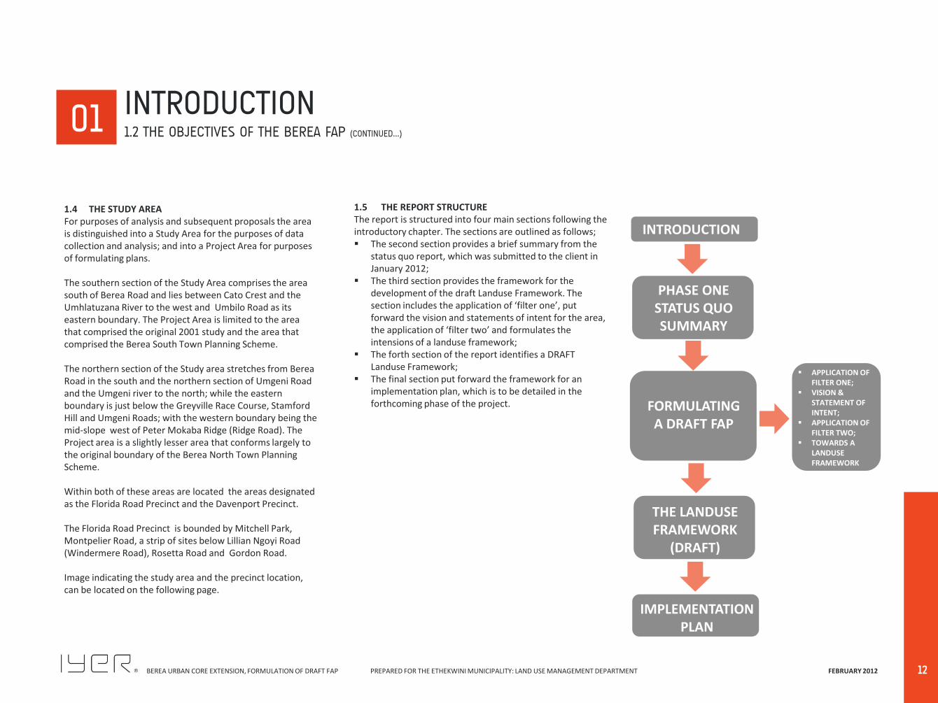
1.5 THE REPORT STRUCTURE The report is structured into four main sections following the introductory chapter. The sections are outlined as follows; The second section provides a brief summary from the
status quo report, which was submitted to the client in January 2012;
The third section provides the framework for the development of the draft Landuse Framework. The section includes the application of ‘filter one’, put forward the vision and statements of intent for the area, the application of ‘filter two’ and formulates the intensions of a landuse framework;
The forth section of the report identifies a DRAFT Landuse Framework;
The final section put forward the framework for an implementation plan, which is to be detailed in the forthcoming phase of the project.
INTRODUCTION
FORMULATING A DRAFT FAP
THE LANDUSE FRAMEWORK
(DRAFT)
IMPLEMENTATION PLAN
APPLICATION OF FILTER ONE;
VISION & STATEMENT OF INTENT;
APPLICATION OF FILTER TWO;
TOWARDS A LANDUSE FRAMEWORK
PHASE ONE STATUS QUO SUMMARY

BEREA URBAN CORE EXTENSION, FORMULATION OF DRAFT FAP PREPARED FOR THE ETHEKWINI MUNICIPALITY: LAND USE MANAGEMENT DEPARTMENT FEBRUARY 2012
00 01
13
INTRODUCTION 1.4 STUDY AREA (CONTINUED…)
DAVENPORT PRECINCT FLORIDA ROAD PRECINCT
BEREA NORTH & SOUTH STUDY AREA
BEREA URBAN CORE EXTENSION, FORMULATION OF DRAFT FAP PREPARED FOR THE ETHEKWINI MUNICIPALITY: LAND USE MANAGEMENT DEPARTMENT FEBRUARY 2012
14
BEREA URBAN CORE EXTENSION, FORMULATION OF DRAFT FAP PREPARED FOR THE ETHEKWINI MUNICIPALITY: LAND USE MANAGEMENT DEPARTMENT FEBRUARY 2012
PHASE ONE STATUS QUO SUMMARY
02

BEREA URBAN CORE EXTENSION, FORMULATION OF DRAFT FAP PREPARED FOR THE ETHEKWINI MUNICIPALITY: LAND USE MANAGEMENT DEPARTMENT FEBRUARY 2012
16
BEREA URBAN CORE EXTENSION, FORMULATION OF DRAFT FAP PREPARED FOR THE ETHEKWINI MUNICIPALITY: LAND USE MANAGEMENT DEPARTMENT FEBRUARY 2012
17
2.1 The Over-Arching Finding of the Analysis The Berea is not merely another suburb, but as the name of the study indicates, i.e. the Urban Core Extension, it performs several roles, viz
Some areas perform City-Wide roles;
Some areas perform Berea-Wide Roles; and
Some areas perform local level roles. Consequently the Berea is a complex set of areas and uses, with a ‘richness’ and ‘complexity’ leading to a high level of liveability within a dense and compact area at its centre. The area comprises a strong set of ‘Imageability’ elements that gives rise to the ‘fine-grain’ nature of the area. The main overarching conclusion of this phase requires
achieving an appropriate urban balance between nurturing the levels of complexity and choice, whilst maintaining the integrity of the area, both from a residential and liveability point of view, whilst also in ensuing the highest quality and functionality of current business environments.
2.2 The Spatial Structure The Spatial and Land Use Characteristics of the Berea identifies:
A series of Major and Minor Nodes, where the major Nodes perform City-Wide functions; while the minor Nodes perform Berea-wide functions;
A series of Residential Neighbourhoods, that distinguishes between a set of detached housing Neighbourhoods; a set of neighbourhoods that are dominated by the development of flats – some of which are medium–rise older walk-up flats and a set
00 02
of newer higher-rise flats; The commercial Nodes form a basis of Mixed-Use
Districts; largely within a comfortable walking distance;
A set of three Mixed-Use Corridors, viz the Florida Road city-wide corridor; the smaller Helen Joseph Road (Davenport Road) corridor; and the Berea-wide Lilian Ngoyi Road (Windermere Road) Corridor;
A set of office conversion areas, especially in older areas containing many Listed Buildings; and
The movement lattice ensures high levels of ‘Permeability’.
It remains to identify and determine which Districts to maintain, which to reinforce and which to constrain. 2.3 Trends and Demands Over the last decade a combination of conversion and minor redevelopment has seen the emergence of office and restaurant uses as extensions of most of the major and some of the minor Nodes. In some cases these extensions have extended beyond comfortable walking distances and will limit the ability to create integrated Districts. In most cases it appears that these conversions have occurred legally, as Consent Uses, and in many cases these changes appear to be illegal. These trends are beginning to create a ‘Domino effect’ and are starting to threaten the integrity of the various Residential Neighbourhoods. In order to address the requirements of the Brief, the analysis begins to suggest that non-residential uses should be contained within the Mixed-Use Districts and should not be permitted to ‘invade’ residential neighbourhoods.
2.4 Traffic and Transportation For the most part, all major and minor roads are in good condition and capable of performing their roles A relatively small number of Intersections are at the stage that they are beginning to be ‘stressed’. These will have to be addressed. The change in use in the older residential uses to mostly office uses has traffic and parking implications. Most of the office conversion areas occur in areas with narrow roads and on small sites such that these conversions cannot absorb or mitigate the traffic impacts and the parking generated. This will inhibit full redevelopment of these areas unless parking reservoirs are able to be created. The grid-iron lattice of roads has a latent public transportation potential; particularly as many nodes and other uses are located on or adjacent to them. This potential should be beneficiated. Existing pedestrian orientated areas should be protected and enhanced with ‘traffic-calming’ measures. Where appropriate, cycle paths should be considered. 2.5 Bulk Infrastructure Both Stormwater and sewerage reticulation systems are showing their age and require constant maintenance. Any larger scale developments will require stormwater management plans. There is some capacity for sewerage services, but any substantial increase in development density will require reconsideration.
PHASE ONE STATUS QUO SUMMARY
BEREA URBAN CORE EXTENSION, FORMULATION OF DRAFT FAP PREPARED FOR THE ETHEKWINI MUNICIPALITY: LAND USE MANAGEMENT DEPARTMENT FEBRUARY 2012
18
2.6 Environmental Issues The Berea as a whole is largely ‘transformed’ with only a few areas with indigenous vegetation. The Berea is a well vegetated area with many tree-lined streets that are part of the character of the area in particular Berea South. New development and redevelopment should be encouraged to retain existing trees and avoid large scale removal of vegetation; especially for ‘sustainability’ reasons. 2.7 Precinct Key issues 2.7.1 Davenport Precinct The Davenport Precinct functions at a suburban level and serves a neighbourhood function. The mix of active uses is centered at the core. There is a clear movement system within the precinct as the area has a grid network and this assists in the permeability of the area. Whilst the precinct is adequately serviced by sidewalks, the area does not appropriately resolve pedestrian /vehicular conflict at key nodes or interceptory points particularly around the Davenport Centre. Visually the area is pleasing. Most of the roads are tree lined with canopies that form a boulevard affect which is typical of this area. The area is characterised by numerous listed buildings which occurs throughout the precinct. The listed buildings closer to the core have been refurbished however Glenwood is noted for its older buildings which often are difficult and expensive to maintain. The area is well serviced by taxis and Municipal buses which service the main routes through this area. Owing to its mixed use nature, the area has all the amenities within a walking distance. The Davenport Centre is the local Neighbourhood shopping node, Helen Joseph and Brand Road has an array of retail,
00
business and office opportunity, combined with religious and recreational activities such Bulwer Park, make’s this area highly convenient and desirable for people that reside in the area, however Bulwer park has been seemingly inactive for many years as it was perceived as a very unsafe environment to use as a recreational space. Poor lighting, no clear pedestrian structure and basic security of this area has seen people consider this vital space a negative area. The eThekwini Council, Architectural Department is currently in the design phase of the project aiming to rejuvenate Bulwer Park. The study revealed that there are approximately 23 109m2 of additional bulk available within the precinct. Whilst the scheme does allow for additional bulk within certain zones, achieving this would be rather difficult as granting additional bulk may further compound the parking problems within the precinct if the developments do not cater for on-street parking. 2.7.2 Florida Road Precinct The Florida precinct serves a city wide and local function. Apart from the visual, aesthetic character of the street, the precinct has a very distinctive quality made up of mixed uses. The precinct is anchored in the north by Mitchell Park which serves as a recreational gateway. The Florida Road Precinct is characterised by a grid network which is an extension of the city grid. This makes the area permeable, creating a circuit which favours both the pedestrian, as well as vehicular traffic, however Florida Road is not entirely pedestrian friendly as attempts have been made to create designated pedestrian crossings at key intersections however there are still occurrences where people speed along this street. The area is well serviced by
taxis, bus which includes the Mynah Bus service that has routes throughout this area. Owing to its mixed use nature, the area has all the amenities within a walking distance. The Windermere centre is the local neighbourhood shopping node, Florida road has an array of retail, business and office opportunity, combined with religious and recreational activities. Visually the area is pleasing, combined with the vibrant energy of Florida Road, the area is unique which attracts both tourists and locals. The area is characterised by numerous listed buildings with many refurbished to its original condition. This together with the diversity in the mix of uses makes this area highly desirable attractive. The precinct has tree planting but is very sparse and not consistent throughout. The market space upgraded recently between Gordon Road and Florida Road is underutilised especially during the weekly days. Florida Road has been recently upgraded where the focus has been on improving the aesthetic appearance of the road, pavement treatments of the intersections, sidewalks and improved lighting within the precinct. Although significantly improved the treatment of the road surfaces has not deterred speeding along this highly active road. There are approximately 77 500m2 of additional bulk available within the precinct. Whilst the scheme does allow for additional bulk within certain zones, achieving this would be rather difficult as granting additional bulk may further compound the parking problems within the precinct if the developments do not cater for on-street parking. PLEASE NOTE: The full status quo document must remain the primary referencing document for this phase of work.
PHASE ONE STATUS QUO SUMMARY
BEREA URBAN CORE EXTENSION, FORMULATION OF DRAFT FAP PREPARED FOR THE ETHEKWINI MUNICIPALITY: LAND USE MANAGEMENT DEPARTMENT FEBRUARY 2012
FORMULATING A DRAFT FAP
03

BEREA URBAN CORE EXTENSION, FORMULATION OF DRAFT FAP PREPARED FOR THE ETHEKWINI MUNICIPALITY: LAND USE MANAGEMENT DEPARTMENT FEBRUARY 2012
20
BEREA URBAN CORE EXTENSION, FORMULATION OF DRAFT FAP PREPARED FOR THE ETHEKWINI MUNICIPALITY: LAND USE MANAGEMENT DEPARTMENT FEBRUARY 2012
21
3.1.1 THE FUNCTIONAL AREA PLAN PROCESS Summarising the Situational Analysis: The Situational Analysis of the FAP area, as undertaken in Phase 1, involved a conventional suite of analytical tools, which resulted in identifying the characteristics of the current reality. The analysis of the whole Berea area identified a ‘Structure’ for the Berea in that it comprised a range of different types of areas; mainly Neighbourhoods, Districts and Corridors, together with a set of Nodes, Landmarks, Edges and Paths (vehicle and pedestrian). The next step in the process of preparing a FAP is to subject the analysis to a series of ‘Filters; which are: Application of ‘Filter 1’ - This process applies
theoretical, conceptual, ‘Good Practice’ and ‘Urban Performance’ measures in order to create a vision for the area, unencumbered with the constraints of certain ‘Realities’. This will result in an initial ‘idealized’ approach to the preparation of the FAP, which will include a diagramised concept and its further development as a Spatial Concept plan.
Application of ‘Filter’ 2 - This process involves the
application of Zoning, the existing situation, trends and demands, and infrastructural constraints to formulate a ‘Draft’ Functional Area Plan. This stage will result in a reality based modification into a Draft Functional Area Plan.
The Draft Functional Area Plan will identify the broad proposed structure for the Berea, which will identify the indicative potential zones.
00 03
The final component of the FAP will be the preparation of an ‘Implementation Plan’. This plan will identify further actions emanating from the analysis and the proposals of the FAP itself. It will identify additional issues to be researched, e.g. the identification of additional precinct, nodal and corridor that would have to be prepared, any projects for possible implementation. The FAP will be set up in terms of a Land Use Framework which will be a precursor for the guiding the formulation of an appropriate Scheme.
FORMULATING A DRAFT FAP 3.1 THE APPROACH
BEREA URBAN CORE EXTENSION, FORMULATION OF DRAFT FAP PREPARED FOR THE ETHEKWINI MUNICIPALITY: LAND USE MANAGEMENT DEPARTMENT FEBRUARY 2012
22
The aim of this stage is to identify a basic approach or set of principles in order to formulate the beginnings of a ‘Vision’ for the Berea Study Area. The application of the above issues needs to be in response to a number of questions, i.e. What is the role of the Berea? What has changed, and what is changing? What can still change? What will /should not change, vis a vis the role of the
Berea? What are the limits for change, by type of land use and
type of structural component? How should the existing ‘Character’ be maintained and
retained, and where? Where should residential integrity be protected and
where should increased workplace opportunities be permitted?
How should ‘change’ be accommodated? How should the impacts of change be mitigated? How to improve the quality and sustainability of the
Berea? Many of the answers to the questions are mutually reinforcing; and the responses tend to indicate an integrated response. 3.2.1 WHAT IS THE ROLE OF THE BEREA? The role of the Berea is that it is a multi-functional and diverse area forming the extension of the City Core; and therefore possesses uses that perform a city-wide role, while simultaneously performing local role functions Consequently, the Berea is comprised of a number of neighbourhoods, precincts and corridors, and associated
00
Nodes, each defined by its attributes in terms of function, built form and character. The structure of the Berea into these distinct areas allows consideration of the specifics of each setting and ensures that new development is appropriate to its location. The Structural analysis map in the previous section depicts these neighbourhoods, precincts and corridors. 3.2.2 WHAT HAS CHANGED, AND WHAT IS CHANGING? All the major City-wide Mixed-Use Districts (and their nodal focus) have grown and consolidated with accretions of associated land use extensions, mostly in the form of conversion of existing residential buildings for office purposes. The two major office conversion areas, viz below Davenport Centre and around Windermere Centre have tended to consolidate themselves. The minor, Berea-wide Mixed use Districts, have also grown by accretion of converted housing for office purposes. The Florida Road City-wide Entertainment Corridor has continued to consolidate itself The small Helen Joseph Road (Davenport Road) Entertainment Corridor has also consolidated its role with several previous office conversions subsequently changing to restaurant use. The clusters of retail and office uses along the Lilian Ngoyi Road (Windermere Road) Corridor have maintained their uses with some minor accretions.
Therefore, based on the above, it is evident that the emerging patterns of change experienced over the last decade has consolidated into established business nodes as part of land use profiles over the Berea. 3.2.3 WHAT CAN STILL CHANGE? The centrally located areas zoned for flats are fairly well developed with relatively few sites that could be redeveloped. The difference between General Residential 1 and General Residential 2 zones is no longer appropriate and a range of different size units is an appropriate direction to take. Most of the mixed residential neighbourhoods still possess substantial redevelopment opportunities, except for those with many Listed Buildings. The redevelopment of these areas should be constrained from occurring as high-rise developments on the lower slopes to mitigate the impact of a ‘Heat island’. The areas zoned for Maisonettes needs to be reconsidered to induce redevelopment at relatively higher densities. Depending on their location some could be rezoned for medium density housing in order to interface with adjacent detached low-rise housing areas; and some could be considered for rezoning to General Residential types development. Therefore, in the main, the sectors that are most likely to change relate to the alteration and extension of the nodes at the centre of the Mixed-use Districts; the amendment of the Maisonette zone to Medium density Housing and General Residential type housing and the consolidation of specific areas as Urban type office clusters.
00 03 FORMULATING A DRAFT FAP
3.2 APPLICATION OF FILTER ONE
BEREA URBAN CORE EXTENSION, FORMULATION OF DRAFT FAP PREPARED FOR THE ETHEKWINI MUNICIPALITY: LAND USE MANAGEMENT DEPARTMENT FEBRUARY 2012
23
3.2.4 WHAT WILL / SHOULD NOT CHANGE, VIS A VIS THE ROLE OF THE BEREA?
The perimeter residential neighbourhoods continue to maintain their residential integrity particularly as detached housing areas. There is, as yet, no pressure for change in these areas, and areas such as Morningside and Glenwood are retained as some of the city’s best residential areas. Most of these areas comprise small and medium sized lots which are not conducive to densifying through the mechanism of inserting of a second dwelling. Some of the residential neighbourhoods with larger lots could be considered for this form of densification. The integrity of the various residential neighbourhoods should be protected from additional and further conversions extending into adjacent residential areas. The residential components of the major Mixed-use districts could be considered for densification with an increase of bulk to induce redevelopment in these Districts. An increase of bulk and appropriate rezoning could be considered for the office /commercial in these Districts. It is recommended that the Mixed-use Districts should be consolidated, but with limitations imposed on the horizontal extent in order to preserve the integrity of the adjacent residential areas. Therefore, the peripheral suburban detached neighbourhoods will not be subject to change; the areas for flats will remain largely intact; the Maisonette zones will be altered depending on their relationship to adjacent zones; and the office conversion areas will be consolidated as such; while a few specific areas will be induced to redevelop as ‘Urban’ Office clusters.
3.2.5 WHAT ARE THE LIMITS FOR CHANGE, BY TYPE OF LAND USE AND TYPE OF STRUCTURAL COMPONENT?
Both the major Mixed-use Districts and minor Mixed Use Districts should be contained by a walking distance locus that will facilitate and integrate the associated land uses. This will have the effect of constraining and reducing the spread (Invasion) of non-residential land uses; whilst at the same time creating a distinct Edge for these various Districts and Neighbourhoods. The Overport Centre Node /District is awkwardly located across a major road intersection and this does not facilitate an easy and comfortable integration. The spread of business services and service industry west of both Umgeni and Umbilo Roads is inimical to a successful interface with residential development; and should not be permitted to extend, as well as having its impacts mitigated by being treated as some form of ‘buffer’ or Interface zone. Therefore, non-residential uses are to be consolidated in and about the major nodes /Districts and constrained by an appropriate walking distance to enhance the possibility of being integrated and coordinated. 3.2.6 HOW SHOULD THE EXISTING ‘CHARACTER’ BE
MAINTAINED AND RETAINED, AND WHERE? The following approach or principles are the foundation of the Functional Area Plan and the basis for the development of a Land Use Framework. Several mechanisms are available to achieve the protection, maintenance and enhancement of the different Neighbourhoods and Districts. These approaches will apply at the Urban Design level of resolution, and includes principles that seek to Retain and Preserve; Maintain; Repair; Replace; Replacement of missing feature
should be based on historical, pictorial and physical Evidence; Alterations and Additions; Demolitions and New Buildings; and Landscaping. The goal of these PRINCIPLES is to improve the quality of the environment in Berea as a whole; particularly to ensure that those elements, which contribute to the special character of the diverse parts of the area, are retained and enhanced. The main planning objectives in achieving this goal include:
i. Enhancement of Areas of Special Identity noted in the analysis, viz the various neighbourhoods, Districts, Corridors and Precincts identified in this document;
ii. Protection of low-rise, pedestrian-oriented mixed-use areas from the adverse impact of high-rise development;
iii. Protection of residential areas from adverse impacts of commercial expansion /invasion and /or higher density development which is controllable in scale;
iv. Enhancement and protection of historic buildings; v. Improvement of publicly accessible areas (streets and
open spaces); and vi. Excellence in urban design, architecture, and
landscape in private developments; vii. Sustainability of future development, such that
municipal infrastructure services are not strained / respond appropriately to new and innovative technologies coming on stream that will assist in the paradigm shift needed in terms of setting a standard and precedent for future development.
00 00 03 FORMULATING A DRAFT FAP
3.2 APPLICATION OF FILTER ONE (CONTINUED…)
BEREA URBAN CORE EXTENSION, FORMULATION OF DRAFT FAP PREPARED FOR THE ETHEKWINI MUNICIPALITY: LAND USE MANAGEMENT DEPARTMENT FEBRUARY 2012
24
3.2.7 WHERE SHOULD RESIDENTIAL INTEGRITY BE PROTECTED AND WHERE SHOULD INCREASED WORKPLACE OPPORTUNITIES BE PERMITTED?
Residential integrity for all residential neighbourhoods should be protected at all costs. This is a fundamental aspect of the Vision; particularly in continuing to enhance the mixed-use character and unique elements as they interact in terms of proximity to each other and in terms of future issues of sustainability. Therefore, the only areas where non-residential uses should be permitted should be within the Mixed-use Districts in and around the major and minor Nodes within a constraint of walking distance from the relevant node. 3.2.8 HOW SHOULD ‘CHANGE’ BE ACCOMMODATED? Several types of changes should be contemplated, viz Continued conversion of older housing to offices, of
the professional and technical variety. Business and service industry type offices should be restricted to the ‘Interface’ zones along Umgeni and Umbilo roads;
Listed Buildings of all types can be considered for conversion;
Conversion to offices can also can be considered in the two main Office conversion areas i.e. behind Davenport Centre and around Windermere Centre;
Rezoning and redevelopment at higher densities for office development can be considered in a narrow band within the walking distance parameter of the nodes in the Mixed-use Districts of the major nodes only. Only conversion of houses to offices can be considered in and around the minor Mixed-use Districts and the minor nodes;
The various Maisonette zones should be amended to permit medium density and higher densities as is
appropriate; Higher residential densities should be considered
within the walking distance parameters of the Major Mixed-use Districts; and
The narrow roads /lanes and the small sites in the two major Office conversion Districts are already not able to cope with parking being generated and there will have to be an appropriate planning intervention to create reservoirs of parking, if these areas are not to deteriorate.
3.2.9 HOW SHOULD THE IMPACTS OF CHANGE BE
MITIGATED? In all cases the parking and loading requirements should be accommodated on-site. Where this is not possible ,the amount of change should be constrained. This may be achieved through the use of existing public parking areas provided at shopping malls, or with the encouragement of effective public transport provision. Redevelopment at the edges of the Office Conversion areas, at their interface with detached housing areas should be restricted. In these cases redevelopment should be in the form of architecture and scale that is compatible with residential development. 3.2.10 HOW TO IMPROVE THE QUALITY AND SUSTAINABILITY
OF THE BEREA To improve the quality and sustainability of the Berea, should the area not become overcapitalised. Therefore consideration must be given to the increase in traffic congestion, lack of adequate parking facility, lack of public transport provision to cater for increase densities, all of which are not sustainable. The sustainability vision builds on the creation of a community that showcases buildings,
00 00 03 FORMULATING A DRAFT FAP
3.2 APPLICATION OF FILTER ONE
infrastructure and lifestyles that help people reduce consumption and live within the capacity of one planet.
BEREA URBAN CORE EXTENSION, FORMULATION OF DRAFT FAP PREPARED FOR THE ETHEKWINI MUNICIPALITY: LAND USE MANAGEMENT DEPARTMENT FEBRUARY 2012
25
The ultimate vision for the Berea is to create an area that promotes a ‘TOTALITY OF CHOICE’, at all scales – City-Wide, Berea-Wide and Precinct-Wide. In so doing, an urban environment is created, which provides well contained, safe and secure neighbourhoods that are woven together by a dynamic open space structure, enhancing a pedestrian oriented environment that compliments human-scale mixed use business clusters (including commercial, office and residential components), and supported by an efficient public transport service. The vision for the Berea can be achieved through the use of the following guiding principles; Well contained, safe and secure residential
neighbourhoods; A well structured open space system; Focus on a pedestrian friendly environment; Well structured, human-scale mixed-used business
clusters; and Supportive public transport service.
3.3.1 WELL CONTAINED, SAFE AND SECURE RESIDENTIAL
NEIGHBOURHOODS The development of quality neighbourhoods begins with the development of a guiding plan or framework. The aim of this plan should be focused on the overall well-being of the area. The plan should give direction for continued growth and development, simultaneously protecting the individual neighbourhood clusters to retain their unique character. The Berea is made up of a number of unique neighbourhoods clusters – these neighbourhood cluster are identified on the Land Use Framework Plan and detailed within the tables in Section 7.
00
Protection of these neighbourhood clusters can be done though the development of a well structured open space system and movement networks which guard the integrity of the area. Development focus within the identified precincts or along the corridors will reinforce the function, built form and character of that specific elements. Growth and development along the Berea should encourage and nurture the natural growth and progression of the area, whilst retaining the distinctive qualities. To achieve the vision the following distinctive qualities within the neighbourhood, should be maintained; Tree lined streetscapes; Varied architectural style which reflects the cultural
mix of inhabitants – Colonial, Cape Dutch, Victorian, Edwardian and Art Deco;
Range of residential intensities; Context specific, human-scale buildings; Sense of community, which promotes an increased
sense of well-being;
3.3.2 A WELL STRUCTURED OPEN SPACE SYSTEM The open space system provides a soft heart to the Berea. It is made up of various passive and active open spaces, which are in some cases linked via dominant tree lined streets. The tree lined streets provide functional links between different aspects of the study area, and have become one of the main identifiable structuring elements within the area. Limited opportunities exist to create new passive or active open space environments, therefore further growth and development of the ‘green’ system should create meaningful links between existing elements.
Existing tree lined streets should be maintained, and new opportunities in this regard should be encouraged. Mature trees along public routes which present possible danger for the community due to age and instability, should be replaced and not just removed from the system. 3.3.3 PEDESTRIAN FRIENDLY ENVIRONMENT The development of a well structured network of pedestrian and vehicular linkages connecting the open space system and adjacent lots is encouraged. The existing grid system will assist in the promotion of a pedestrian friendly environment; the encouragement of which will support the existing active community within the Berea region. Pavements along street edges is promoted to allow for greater pedestrian activity throughout the area. Pavements, together with the surrounding public realm, should be well-maintained to retain the mobility of the communities. Attractive well looked after public environments provide an invitation to the community to use common grounds, and indirectly promotes a sense of community. Promotion and encouragement of non-motorised transport such as cycling and walking. Development and building fronting onto pedestrian zones require that the built form responds to pedestrian traffic in the it interfaces with the sidewalk, provides weather protection, and visual interest. Street furniture such as lighting, benches and trees to provide protection from the elements are encouraged in these spaces.
00 00 03 FORMULATING A DRAFT FAP
3.3 VISION & STATEMENT OF INTENT
BEREA URBAN CORE EXTENSION, FORMULATION OF DRAFT FAP PREPARED FOR THE ETHEKWINI MUNICIPALITY: LAND USE MANAGEMENT DEPARTMENT FEBRUARY 2012
26
3.3.4 WELL STRUCTURED, HUMAN SCALE, MIXED USE BUSINESS CLUSTERS
Well structured environments allow for a diverse mixed of uses to have a symbiotic relationship. Dynamic mixed use clusters with a range of intensity are supported within specific nodes – nodes to vary in size and intensity due to location and context. Wide spread condoned mixed use environments will be destructive to the overall vision of the area. Therefore, tight, intense mixed use clusters should be encouraged where desired. To maintain distinct clusters clear edges need to be defined and held. Strong identity of these clusters /nodes need to be maintained and reinforced through compatible development. Areas, which show a less dominant identity require a stronger vision to direct future development and public improvements. 3.3.5 SUPPORTIVE PUBLIC TRANSPORT SERVICE The immanent implementation of the eThekwini Integrated Rapid Transport Network (IRPTN) will elevate the Berea further, as a desirable location to settle. The IRPTN mainline system doesn’t penetrate the study area explicitly, however it runs along the edge providing increased opportunities. The existing grid system along the Berea encourages an effective public transport system, which could feed into the main IRPTN network. The development of such a sophisticated system would allow the study area to become a truly world class environment, providing first class services within an integrated setting. The future growth and development of the public realm across the Berea needs to take into consideration the IRPTN system. Well integrated, user friendly environments will
encourage the conversion of traditional individual car users to utilise the public transport network. 3.3.6 OVERALL SUSTAINABILITY In order to promote a well structured open space system specific urban design principles should be taken into consideration to protect the existing environment. These include; Promoting Mixed-use zoning and a diversity of housing
types in each neighborhood; Creating an open space network to encourage natural
diversity, manage water runoff and create local amenity;
Promoting the use of native plant species in both the public and private environment;
Promoting controlled urban agriculture and the use of planting within and on buildings;
Minimizing environmental harm through the use of permeable surfaces and the management of storm-water runoff;
Improve safety, pedestrian connections and lights within local and district parks.
To create a well-rounded environment, a ‘Green Building’ approach should be encouraged to support the structured open space system. The following principles should be considered; Local appropriateness; Conservation of the natural environment; Resource efficiency; Lifecycle approach; Zero waste; Use of renewable resources; Sustainable procurement; Local production for local use;
03 FORMULATING A DRAFT FAP 3.3 VISION & STATEMENT OF INTENT
Human health and wellbeing; Monitoring and evaluation; and Positive legacy.
BEREA URBAN CORE EXTENSION, FORMULATION OF DRAFT FAP PREPARED FOR THE ETHEKWINI MUNICIPALITY: LAND USE MANAGEMENT DEPARTMENT FEBRUARY 2012
27
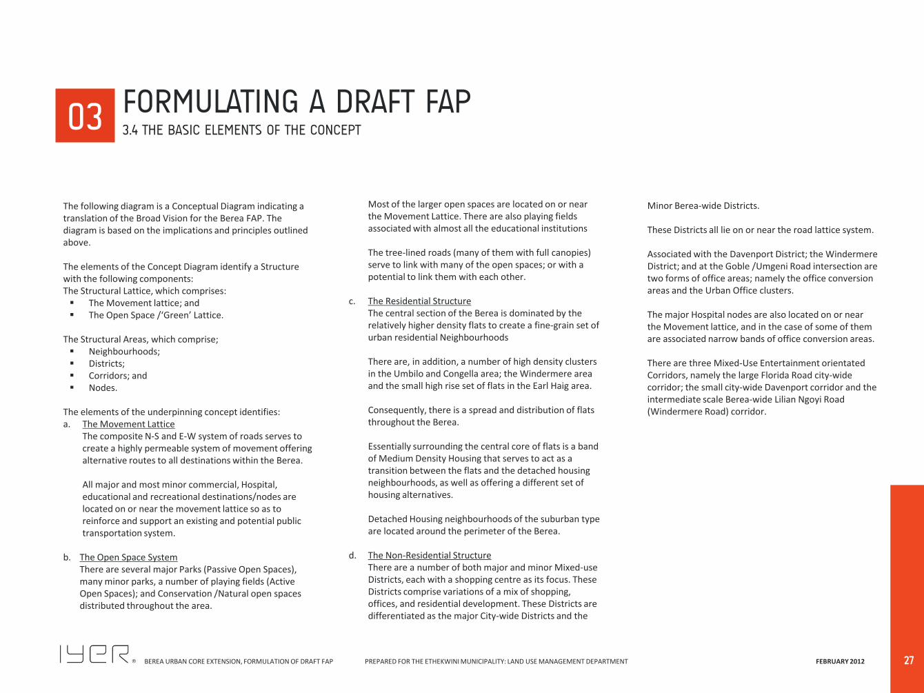
The following diagram is a Conceptual Diagram indicating a translation of the Broad Vision for the Berea FAP. The diagram is based on the implications and principles outlined above. The elements of the Concept Diagram identify a Structure with the following components: The Structural Lattice, which comprises: The Movement lattice; and The Open Space /‘Green’ Lattice.
The Structural Areas, which comprise; Neighbourhoods; Districts; Corridors; and Nodes.
The elements of the underpinning concept identifies: a. The Movement Lattice
The composite N-S and E-W system of roads serves to create a highly permeable system of movement offering alternative routes to all destinations within the Berea. All major and most minor commercial, Hospital, educational and recreational destinations/nodes are located on or near the movement lattice so as to reinforce and support an existing and potential public transportation system.
b. The Open Space System There are several major Parks (Passive Open Spaces),
many minor parks, a number of playing fields (Active Open Spaces); and Conservation /Natural open spaces distributed throughout the area.
00
Most of the larger open spaces are located on or near the Movement Lattice. There are also playing fields associated with almost all the educational institutions
The tree-lined roads (many of them with full canopies) serve to link with many of the open spaces; or with a potential to link them with each other.
c. The Residential Structure
The central section of the Berea is dominated by the relatively higher density flats to create a fine-grain set of urban residential Neighbourhoods There are, in addition, a number of high density clusters in the Umbilo and Congella area; the Windermere area and the small high rise set of flats in the Earl Haig area. Consequently, there is a spread and distribution of flats throughout the Berea. Essentially surrounding the central core of flats is a band of Medium Density Housing that serves to act as a transition between the flats and the detached housing neighbourhoods, as well as offering a different set of housing alternatives. Detached Housing neighbourhoods of the suburban type are located around the perimeter of the Berea.
d. The Non-Residential Structure
There are a number of both major and minor Mixed-use Districts, each with a shopping centre as its focus. These Districts comprise variations of a mix of shopping, offices, and residential development. These Districts are differentiated as the major City-wide Districts and the
Minor Berea-wide Districts. These Districts all lie on or near the road lattice system. Associated with the Davenport District; the Windermere District; and at the Goble /Umgeni Road intersection are two forms of office areas; namely the office conversion areas and the Urban Office clusters. The major Hospital nodes are also located on or near the Movement lattice, and in the case of some of them are associated narrow bands of office conversion areas. There are three Mixed-Use Entertainment orientated Corridors, namely the large Florida Road city-wide corridor; the small city-wide Davenport corridor and the intermediate scale Berea-wide Lilian Ngoyi Road (Windermere Road) corridor.
00 00 03 FORMULATING A DRAFT FAP
3.4 THE BASIC ELEMENTS OF THE CONCEPT
BEREA URBAN CORE EXTENSION, FORMULATION OF DRAFT FAP PREPARED FOR THE ETHEKWINI MUNICIPALITY: LAND USE MANAGEMENT DEPARTMENT FEBRUARY 2012
28
STEPHEN DLAMINI ROAD
MUSGRAVE ROAD
PROBLEM MKHIZE ROAD Z K MATTHEWS ROAD
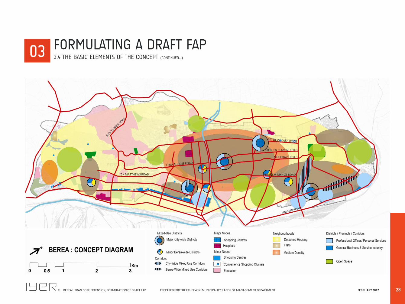
03 FORMULATING A DRAFT FAP 3.4 THE BASIC ELEMENTS OF THE CONCEPT (CONTINUED…)
BEREA URBAN CORE EXTENSION, FORMULATION OF DRAFT FAP PREPARED FOR THE ETHEKWINI MUNICIPALITY: LAND USE MANAGEMENT DEPARTMENT FEBRUARY 2012
29
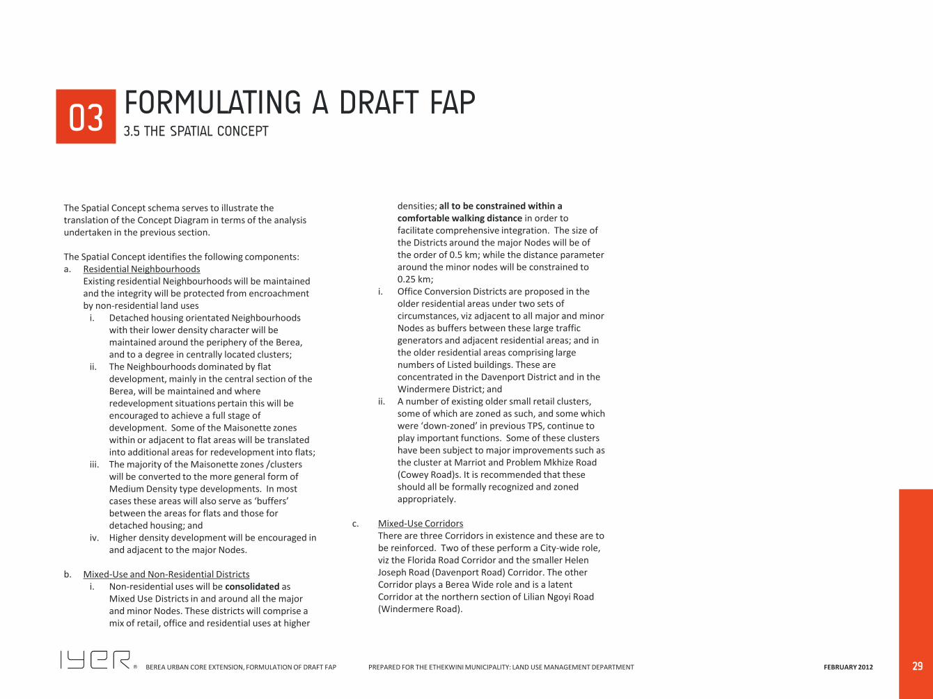
The Spatial Concept schema serves to illustrate the translation of the Concept Diagram in terms of the analysis undertaken in the previous section. The Spatial Concept identifies the following components: a. Residential Neighbourhoods Existing residential Neighbourhoods will be maintained
and the integrity will be protected from encroachment by non-residential land uses
i. Detached housing orientated Neighbourhoods with their lower density character will be maintained around the periphery of the Berea, and to a degree in centrally located clusters;
ii. The Neighbourhoods dominated by flat development, mainly in the central section of the Berea, will be maintained and where redevelopment situations pertain this will be encouraged to achieve a full stage of development. Some of the Maisonette zones within or adjacent to flat areas will be translated into additional areas for redevelopment into flats;
iii. The majority of the Maisonette zones /clusters will be converted to the more general form of Medium Density type developments. In most cases these areas will also serve as ‘buffers’ between the areas for flats and those for detached housing; and
iv. Higher density development will be encouraged in and adjacent to the major Nodes.
b. Mixed-Use and Non-Residential Districts
i. Non-residential uses will be consolidated as Mixed Use Districts in and around all the major and minor Nodes. These districts will comprise a mix of retail, office and residential uses at higher
densities; all to be constrained within a comfortable walking distance in order to facilitate comprehensive integration. The size of the Districts around the major Nodes will be of the order of 0.5 km; while the distance parameter around the minor nodes will be constrained to 0.25 km;
i. Office Conversion Districts are proposed in the older residential areas under two sets of circumstances, viz adjacent to all major and minor Nodes as buffers between these large traffic generators and adjacent residential areas; and in the older residential areas comprising large numbers of Listed buildings. These are concentrated in the Davenport District and in the Windermere District; and
ii. A number of existing older small retail clusters, some of which are zoned as such, and some which were ‘down-zoned’ in previous TPS, continue to play important functions. Some of these clusters have been subject to major improvements such as the cluster at Marriot and Problem Mkhize Road (Cowey Road)s. It is recommended that these should all be formally recognized and zoned appropriately.
c. Mixed-Use Corridors
There are three Corridors in existence and these are to be reinforced. Two of these perform a City-wide role, viz the Florida Road Corridor and the smaller Helen Joseph Road (Davenport Road) Corridor. The other Corridor plays a Berea Wide role and is a latent Corridor at the northern section of Lilian Ngoyi Road (Windermere Road).
03 FORMULATING A DRAFT FAP 3.5 THE SPATIAL CONCEPT
BEREA URBAN CORE EXTENSION, FORMULATION OF DRAFT FAP PREPARED FOR THE ETHEKWINI MUNICIPALITY: LAND USE MANAGEMENT DEPARTMENT FEBRUARY 2012
30
MUSGRAVE ROAD
PROBLEM MKHIZE ROAD Z K MATTHEWS ROAD
03 FORMULATING A DRAFT FAP 3.5 THE SPATIAL CONCEPT (CONTINUED…)
STEPHEN DLAMINI ROAD
BEREA URBAN CORE EXTENSION, FORMULATION OF DRAFT FAP PREPARED FOR THE ETHEKWINI MUNICIPALITY: LAND USE MANAGEMENT DEPARTMENT FEBRUARY 2012
31
This process involves the application of Zoning, the existing situation, trends and demands, and infrastructural constraints to formulate a ‘Draft’ Functional Area Plan. This stage will result in a reality modified Draft Functional Area Plan , in the form of a Land Use Framework. Implications of the Existing Zoning system
a. To a large extent zoning proposals should not deviate substantially from the existing situation. Changes or amendments to the existing zoning regime can more readily increase the range of uses permitted in a zone and /or the intensity of development of those uses. Any form of ‘down-zoning’ should be limited to meet essential requirements as it is legally difficult to reduce owners ‘rights’; although any changes always imply the continuation of those rights as ‘non-conforming use rights’;
b. The several clauses in the existing TPS have permitted a number of alterations to the intent of the original Scheme and have even gone beyond some of the intentions of the 2001 proposals. Some of these implications have already been reduced in this proposal; and some others might also have to be reconsidered if the integrity of residential areas is to be maintained;
c. Any changes need to consider appropriate simplification of the Scheme;
d. Changes need to consider appropriate densification of type and location;
e. Where appropriate, new zones need to be introduced; f. Notwithstanding of the above points the existing
system will largely determine the nature of the proposed FAP;
g. The majority of the major and minor shopping nodes are all zoned General Shopping; while the majority of
the local Convenience clusters are zoned Special Shopping. In addition, many non-conforming Existing Use Rights zoned out in previous TPS’s need to be reconsidered as being zoned for Special Shopping again.
Trends and Demands The section on the imperatives for change and the existing land use analysis have indicated that there has been a ‘spread’ and proliferation of non-residential uses in a number of ways, viz
a. The extension of non-residential uses, mainly in the form of office conversions around most of the major and minor nodes;
b. The proliferation of such uses that have ‘leap-frogged’ away from such nodes along many of the major arterials;
c. The continued creeping invasion of business type uses, rather than professional /technical offices, from both Umgeni and Umbilo Roads;
d. The consolidation of office conversions in the Windermere and Davenport District areas;
e. The decentralisation of headquarter type offices, that were seen in 2001, and have now moved to La Lucia, Westway and Hillcrest. The demand appears to be for small scale office formats and it is unlikely that major redevelopment for these purposes is likely to occur; and
f. In particular, the areas designated for offices, in the 2001 plan, are in areas with many Listed Buildings which will constrain major redevelopment in any event. Secondly, the narrow lanes and roads in the Windermere District will also inhibit the possibility of substantial redevelopment
03 FORMULATING A DRAFT FAP 3.6 APPLICATION OF FILTER TWO
BEREA URBAN CORE EXTENSION, FORMULATION OF DRAFT FAP PREPARED FOR THE ETHEKWINI MUNICIPALITY: LAND USE MANAGEMENT DEPARTMENT FEBRUARY 2012
32
3.7.1 THE APPROACH A ‘Land Use Framework’ (LUF) primarily identifies the range /type of zones appropriate to the area under consideration. The subsequent formulation of a Land Use Scheme (or Planning Scheme) will compile the requisite detail that comprises a Scheme document and map. The LUF is, therefore, a precursor to the formulation of a Planning Scheme. As such it identifies, in broad terms, the nature of the intended zoning categories that will be determined for the Scheme. It does not directly address the details embodied in the written part of a Scheme, viz. It does not address; The preparation of a schedule of General Definitions; A schedule of Land Use and Building Definitions; The preparation of a table of uses related to zones, i.e.
the specific details of land uses (whether Free Entry, Consent Use, or Prohibited); or
The development regulations pertaining to those zones.
However, a Land Use Framework will indirectly or implicitly, identify or ‘flag’ aspects of the 4 listings quoted above. Essentially, the LUF identifies the “intent” of the different zones that will be developed in the formulation of a Scheme. The process of formulating a LUF comprises several aspects; viz. Analyzing the current TPS areas; Adjusting for and being informed by the analysis and
the Vision for the Berea; Detailing and elaborating the use areas identified in
the analysis and in the Vision;
00
Modifying the existing TPS’s in terms of the directives explicit and implicit in the Vision; and Applying and extending use zones to the areas
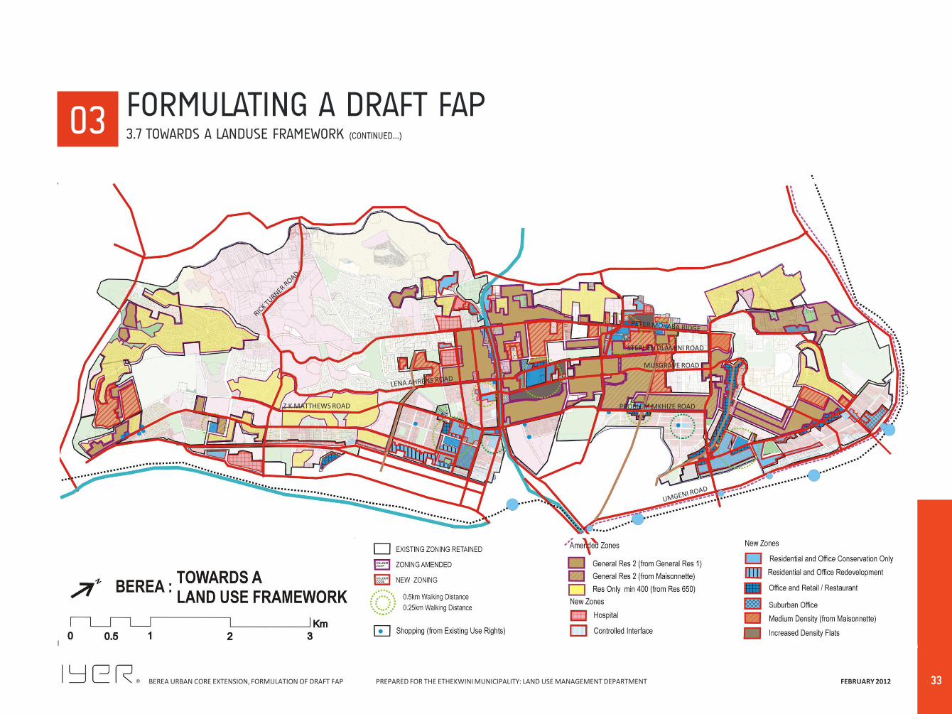
previously not managed by the TPS’s. In this particular case, as it is not quite clear how eThekwini will be applying the LUMS system for a Scheme, the approach to be taken will indicate the current TPS nomenclature for zones as well as its possible translation into a LUMS type scheme approach. Consequently the table to follow will identify the zones using both the present zone names and the possible LUMS scheme zone names, as anticipated. The areas of the Berea where these various changes have been recommended are clearly mapped on the ‘Towards a Land-Use Framework’ map. The LUF map will identify zones in three ways; viz.
a. Where there is no alteration to these zones being recommended, the map will leave these areas ‘untouched’. This is marked by a Black outline;
b. Where existing zones will be altered /amended or ‘translated’ as indicated in the FAP approach, the areas will be demarcated with a particular colour (Purple) boundary, so that those who will be responsible for translating the LUF into a Land Use Scheme will have a clear directive to do so; and
c. In the case of new zones the areas will be demarcated in terms of the characteristics (Statements of Intent) and the LUMS type nomenclature in the colour (RED).
03 FORMULATING A DRAFT FAP 3.7 TOWARDS A LANDUSE FRAMEWORK
BEREA URBAN CORE EXTENSION, FORMULATION OF DRAFT FAP PREPARED FOR THE ETHEKWINI MUNICIPALITY: LAND USE MANAGEMENT DEPARTMENT FEBRUARY 2012
33
MUSGRAVE ROAD
PROBLEM MKHIZE ROAD Z K MATTHEWS ROAD
00 03 FORMULATING A DRAFT FAP
3.7 TOWARDS A LANDUSE FRAMEWORK (CONTINUED…)
STEPHEN DLAMINI ROAD
BEREA URBAN CORE EXTENSION, FORMULATION OF DRAFT FAP PREPARED FOR THE ETHEKWINI MUNICIPALITY: LAND USE MANAGEMENT DEPARTMENT FEBRUARY 2012
34
Clearly some areas have obviously been impacted upon by their location near to major non-residential land uses or major transport routes and could be considered for change of land use. Significantly enough, there are large parts of the Berea, which are remarkably stable and they have not been subject to any changes or development pressures other than the normal pressures as a result of living in a fairly high density residential area within a major metropolitan setting. The following section describes the major changes arising from the land use management proposals and is directly related to the preparation of a Land Use Framework as part of this project, which will guide the subsequent preparation of a detailed Scheme for the area. The following map identifies the broad nature of the proposed FAP. The approach taken is a constraining approach, so that non-residential uses are restricted to occur within walking distance of the various nodes and in the areas demarcated in the 2001 plan for change. Under this approach, many of the non-residential developments that have evolved over the last decade, whether legal or illegal will fall outside of the walking distance parameter. The plan for developing the LUF indicates the following principles: a. Unaltered Zones
i. To a large extent the peripheral detached housing areas, both north and south, will remain largely unaltered in terms of their zoning (This point will be returned to later in the next section);
ii. The General Residential 2 zones will also remain largely unaltered;
iii. The associated and related zones such as those for educational and open spaces will also remain
largely unaltered.
b. Amended Zones i. All the General Residential 1 Zones will be conflated
and amended to be the same as General Residential 2 zoning. This will permit a level of increased density as smaller dwelling units can be established. This concentrates the higher densities in the central portion of the Berea to substantiate an urban fabric;
ii. Some of the centrally located Maisonette zones will be amended to become Medium Density zones that will act as buffers between the high density areas and the detached housing areas.
c. New Zones
i. The older Maisonette zones adjacent to General Residential areas in the central areas of the Berea and along the mid-slope will be converted to General Residential 2 zones;
ii. A number of clusters that form part of some of the major Mixed-Use Districts will be induced to create a higher density in the vicinity of the major Node;
iii. The areas proposed in the 2001 plan for office conservation will be retained to a large extent as an area primarily for Office conversion, and no other uses;
iv. A small narrow band of sites adjacent to some of the major Nodes will permit a level of low scale redevelopment;
v. The 3 Mixed-use Corridors permit an increased number of activities that generate traffic and other externalities. These areas will be able to
accommodate uses such as restaurants and speciality shop outlets, as well as a range of personal services;
vi. In a few areas where the area will have no impact on adjacent residential areas or listed Building a more conventional Urban Office format redevelopment will be encouraged; and
vii. Reintroducing Special Shopping Zones for appropriately located Existing Use rights that have been redeveloped.
d. Zoning Areas vs. the Application of the Consent Use
Procedure i. Once an area is zoned, there is a limited
opportunity to manage and regulate the Free Entry Uses. This approach will be applied to all the different forms of non-residential uses within the walking distance parameter of each major Node/ District;
ii. Non-residential uses beyond the walking distance parameter will be managed via the Consent Use procedure, using the existing Town Planning Scheme Clauses that permit such application. In this way uses and their mitigation can be applied relative to the nature of each application;
iii. All Consent Use adjustments outside of the walking distance parameter should limit use to the professional technical types only. Uses that generate constant traffic such as medical offices, business offices and personal services should be limited/ restricted to avoid further impacts on residential areas.
00 03 FORMULATING A DRAFT FAP
3.7 TOWARDS A LANDUSE FRAMEWORK
BEREA URBAN CORE EXTENSION, FORMULATION OF DRAFT FAP PREPARED FOR THE ETHEKWINI MUNICIPALITY: LAND USE MANAGEMENT DEPARTMENT FEBRUARY 2012
THE LAND USE FRAMEWORK (DRAFT)
04

BEREA URBAN CORE EXTENSION, FORMULATION OF DRAFT FAP PREPARED FOR THE ETHEKWINI MUNICIPALITY: LAND USE MANAGEMENT DEPARTMENT FEBRUARY 2012
36
BEREA URBAN CORE EXTENSION, FORMULATION OF DRAFT FAP PREPARED FOR THE ETHEKWINI MUNICIPALITY: LAND USE MANAGEMENT DEPARTMENT FEBRUARY 2012
37
The areas of the Berea where various Land Use changes have been recommended are clearly mapped on the ‘Towards a Land-Use Framework’ map. The table below will identify: The ‘Translation’ of the current zones for purposes of
the LUF; and The introduction/consideration of “new” zone types.
The Land Use Framework follows the following principles: The existing nature of the zoning of the current
developments and TPS’s will be retained, where appropriate;
The two existing General Residential zones (Gen Res 1 and Gen Res 2) are to be conflated into a single zone, using the Gen Res 2 zone approach;
The existing Maisonette zones will be rezoned to either Gen Res 2 or to a Medium Density Housing type, according to the Approach outlined above;
The various proposed ‘office’ zones will reflect the intention to differentiate the degree of non-residential uses permitted and will use the principles embodied in the LUMS zones identified as Residential Medium Impact and Residential High Impact zones;
The generally defined Institutional zones will be more clearly differentiated as specific Hospital zones in terms of their current use, as well as Municipal and Government and separated Institution zones.
A new ‘Urban Office’ zone will be applied in some areas; and
A new higher density Residential zone will be introduced to align with the intentions of the Vision and as indicated in the way forward. The current General Residential 3 (FAR 1.5) zone will be applied. (Could apply a higher FAR).
00 04 THE LANDUSE FRAMEWORK (DRAFT)
4.1 INTRODUCTION
BEREA URBAN CORE EXTENSION, FORMULATION OF DRAFT FAP PREPARED FOR THE ETHEKWINI MUNICIPALITY: LAND USE MANAGEMENT DEPARTMENT FEBRUARY 2012
38
PARENT TYPE
EXISTING BEREA TPS ZONE
2001 BEREA PROPOSALS
2012 RECOMMENDATIONS 2011 LUMS NEW GUIDELINES
STATEMENT OF INTENT 2011 LUMS ZONES
DET
AC
HED
HO
USI
NG
Special Residential Min 180
SPECIAL RESIDENTIAL
MIN 180
A zone that is intended to promote the development of primarily detached dwelling units, and where a limited number of compatible ancillary uses which have a non-disruptive impact on a neighbourhood amenity may be allowed. It excludes uses such as Bed n Breakfast and second dwellings because of the small lot sizes
RESIDENTIAL ONLY DETACHED 180
Special Residential Min 400
Residential Only (min. Lot 400 sqm)
SPECIAL RESIDENTIAL MIN 400 A zone that is intended to promote the development of primarily detached dwelling units, but does permit multi-family dwellings; and where a limited number of compatible ancillary uses which have a non-disruptive impact on a neighbourhood amenity may be allowed.
.
RESIDENTIAL ONLY DETACHED 400
Special Residential Min 650
Special Residential Min 900
Residential Only (min. Lot 900 sqm)
SPECIAL RESIDENTIAL MIN 900 RESIDENTIAL ONLY DETACHED 900
Special Residential Min 1400
Special Residential Min 1800
RESIDENTIAL ONLY DETACHED 1800
MED
IUM
D
ENSI
TY
Maisonette 650 Medium Density Residential
MEDIUM DENSITY HOUSING A zone that is intended to promote the development of attached and detached dwelling units as part of a larger planned residential development.
RESIDENTIAL ONLY MEDIUM DENSITY
Maisonette 900
Maisonette 1400
Duplex 900
FLA
TS
General Residential 1 High Density Residential
(FAR 1.0)
GENERAL RESIDENTIAL 2 A zone that is intended to promote the development of multi-unit residential units for a wide range of residential accommodation at a high density; together with a mix of activities to cater for broader community needs.
RESIDENTIAL ONLY HIGH DENSITY 2 (FAR 1.0)
General Residential 2
General Residential 3 INCREASED FLAT DENSITY A zone that is intended to promote the development of multi-unit residential units for a wide range of residential accommodation at a high density; together with a mix of activities to cater for broader community needs.
RESIDENTIAL ONLY HIGH DENSITY 3 (FAR 1.3 - Could be 1.5)
00 04 THE LANDUSE FRAMEWORK (DRAFT)
4.2 ZONES AND STATEMENTS OF INTENT
BEREA URBAN CORE EXTENSION, FORMULATION OF DRAFT FAP PREPARED FOR THE ETHEKWINI MUNICIPALITY: LAND USE MANAGEMENT DEPARTMENT FEBRUARY 2012
39
PARENT TYPE
EXISTING BEREA TPS ZONE
2001 BEREA PROPOSALS
2012 RECOMMENDATIONS 2011 LUMS NEW GUIDELINES STATEMENT OF INTENT 2011 LUMS ZONES
CO
NV
ERSI
ON
ZO
NES
A
REA
S
Residential & Office Conversion
RESIDENTIAL & OFFICE CONSERVATION ONLY
A zone that retains a high incidence of residential land uses with an increasing number of appropriate ancillary land uses to satisfy local demands and convenience and excludes industrial and trade uses. The residential density may increase. This is essentially a buffer zone where change of use is permitted with preservation of the existing format.
RESIDENTIAL MEDIUM IMPACT
Residential & Offices Conversion 1 (permits Banks and Retail services) Residential & Offices Conversion 2 (permits Redevelopment)
RESIDENTIAL & OFFICE REDEVELOPMENT
A zone that contains all types of residential development and provides a wide range of services and activities, but excludes industrial and trade uses. The residential density may increase. This is essentially an interface zone where change of use is permitted with construction of low–rise residential type buildings.
RESIDENTIAL HIGH IMPACT 1
Impact Residential & Office Conversion (Permits Restaurants)
OFFICE & RETAIL /RESTAURANT A zone that contains all types of residential development and provides a wide range of services and activities, but excludes industrial and trade uses. The residential density may increase. This is essentially an interface zone where change of use is permitted with construction of low–rise residential type buildings.
RESIDENTIAL HIGH IMPACT 2
Architectural Heritage Precinct
ARCHITECTURAL HERITAGE PRECINCT
IND
UST
RY
A zone that permits manufacturing uses which are compatible with land uses permitted in adjacent more sensitive land use zones, such as residential, mixed-use and open space zones. As a light industrial zone, it would permit manufacturing activities that usually do not involve significant vibration, noise, odour, or high volume of automobile and truck traffic. Warehousing of materials considered non-obnoxious or non-hazardous are permitted in buildings in this zone, with possible conditions. Outdoor storage, as an ancillary use, would be extremely limited if not outright prohibited. Office uses would be permitted with conditions in this zone. I.e. with a Consent Use Procedure.
LIGHT INDUSTRY
General Industrial Light Industrial LIGHT INDUSTRIAL Converted to Light Industry. GENERAL INDUSTRY
00 04 THE LANDUSE FRAMEWORK (DRAFT)
4.2 ZONES AND STATEMENTS OF INTENT (CONTINUED…)

BEREA URBAN CORE EXTENSION, FORMULATION OF DRAFT FAP PREPARED FOR THE ETHEKWINI MUNICIPALITY: LAND USE MANAGEMENT DEPARTMENT FEBRUARY 2012
40
PARENT TYPE
EXISTING BEREA TPS ZONE
2001 BEREA PROPOSALS
2012 RECOMMENDATIONS 2011 LUMS NEW GUIDELINES
STATEMENT OF INTENT 2011 LUMS ZONES
CIV
IC &
SO
CIA
L
Educational 1 (Limited to max 3 Floors)
Educational EDUCATIONAL A zone that provides for a full range of educational facilities including, infants, pre-primary, primary, secondary, tertiary and adult education and training with associated buildings and recreational facilities
EDUCATION 1
Educational 2 (No height limitation)
Educational EDUCATIONAL A zone that provides for a full range of educational facilities including, infants, pre-primary, primary, secondary, tertiary and adult education and training with associated buildings and recreational facilities
EDUCATION 2
Crèche Crèche CRÈCHE A zone that provides for buildings or portions of buildings to be used for the care of no less than six or more infants and children during the daytime. Health bylaws must be complied with.
CRECHE
Health and Welfare HOSPITAL This zone provides for the full range of public and private hospital, medical centres, clinics, sanatoria, community care, welfare and social requirements including pension pay points.
HEALTH AND WELFARE
Government and Municipal
GOVERNMENT & MUNICIPAL This zone is intended for buildings erected and used for National, Provincial and Municipal administration and services.
MUNICIPAL AND GOVERNMENT
Institutional 1 Public Buildings and Institutions
INSTITUTIONAL This zone is intended for land and buildings for the accommodation and care of the aged, places of safety and orphanages.
INSTITUTION 1
Institutional 2 INSTITUTIONAL This zone is intended for land and buildings for the accommodation and care of the aged, places of safety and orphanages.
INSTITUTION 2
Place of Worship Worship WORSHIP This zone is intended for land and buildings to be used as a church, chapel, oratory, synagogue, mosque, temple, Sunday school, and other places of public devotion; but does not include a funeral chapel.
WORSHIP
00 04 THE LANDUSE FRAMEWORK (DRAFT)
4.2 ZONES AND STATEMENTS OF INTENT (CONTINUED…)
BEREA URBAN CORE EXTENSION, FORMULATION OF DRAFT FAP PREPARED FOR THE ETHEKWINI MUNICIPALITY: LAND USE MANAGEMENT DEPARTMENT FEBRUARY 2012
41
PARENT TYPE
EXISTING BEREA TPS ZONE
2001 BEREA PROPOSALS
2012 RECOMMENDATIONS 2011 LUMS NEW GUIDELINES
STATEMENT OF INTENT 2011 LUMS ZONES
MIX
ED -
USE
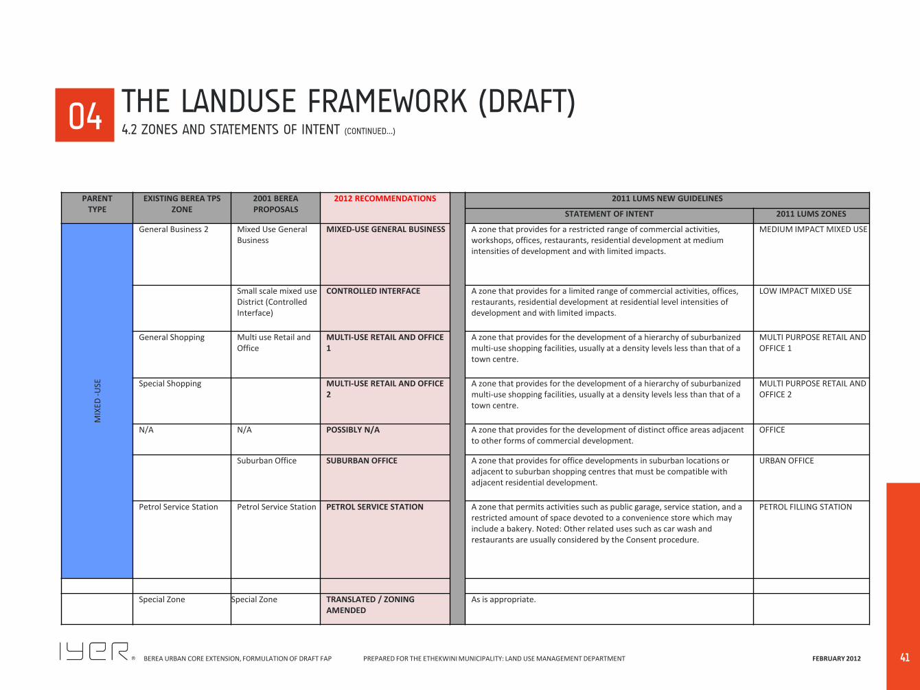
General Business 2 Mixed Use General Business
MIXED-USE GENERAL BUSINESS A zone that provides for a restricted range of commercial activities, workshops, offices, restaurants, residential development at medium intensities of development and with limited impacts.
MEDIUM IMPACT MIXED USE
Small scale mixed use District (Controlled Interface)
CONTROLLED INTERFACE A zone that provides for a limited range of commercial activities, offices, restaurants, residential development at residential level intensities of development and with limited impacts.
LOW IMPACT MIXED USE
General Shopping Multi use Retail and Office
MULTI-USE RETAIL AND OFFICE 1
A zone that provides for the development of a hierarchy of suburbanized multi-use shopping facilities, usually at a density levels less than that of a town centre.
MULTI PURPOSE RETAIL AND OFFICE 1
Special Shopping MULTI-USE RETAIL AND OFFICE 2
A zone that provides for the development of a hierarchy of suburbanized multi-use shopping facilities, usually at a density levels less than that of a town centre.
MULTI PURPOSE RETAIL AND OFFICE 2
N/A N/A POSSIBLY N/A A zone that provides for the development of distinct office areas adjacent to other forms of commercial development.
OFFICE
Suburban Office SUBURBAN OFFICE A zone that provides for office developments in suburban locations or adjacent to suburban shopping centres that must be compatible with adjacent residential development.
URBAN OFFICE
Petrol Service Station Petrol Service Station PETROL SERVICE STATION A zone that permits activities such as public garage, service station, and a restricted amount of space devoted to a convenience store which may include a bakery. Noted: Other related uses such as car wash and restaurants are usually considered by the Consent procedure.
PETROL FILLING STATION
Special Zone Special Zone TRANSLATED / ZONING AMENDED
As is appropriate.
00 04 THE LANDUSE FRAMEWORK (DRAFT)
4.2 ZONES AND STATEMENTS OF INTENT (CONTINUED…)
BEREA URBAN CORE EXTENSION, FORMULATION OF DRAFT FAP PREPARED FOR THE ETHEKWINI MUNICIPALITY: LAND USE MANAGEMENT DEPARTMENT FEBRUARY 2012
42
PARENT TYPE
EXISTING BEREA TPS ZONE
2001 BEREA PROPOSALS
2012 RECOMMENDATIONS 2011 LUMS NEW GUIDELINES
STATEMENT OF INTENT 2011 LUMS ZONES
OP
EN S
PA
CE
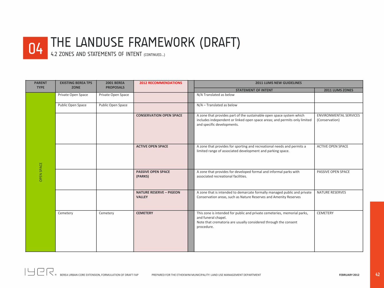
Private Open Space Private Open Space N/A Translated as below
Public Open Space Public Open Space N/A – Translated as below
CONSERVATION OPEN SPACE A zone that provides part of the sustainable open space system which includes independent or linked open space areas; and permits only limited and specific developments.
ENVIRONMENTAL SERVICES (Conservation)
ACTIVE OPEN SPACE A zone that provides for sporting and recreational needs and permits a limited range of associated development and parking space.
ACTIVE OPEN SPACE
PASSIVE OPEN SPACE (PARKS)
A zone that provides for developed formal and informal parks with associated recreational facilities.
PASSIVE OPEN SPACE
NATURE RESERVE – PIGEON VALLEY
A zone that is intended to demarcate formally managed public and private Conservation areas, such as Nature Reserves and Amenity Reserves
NATURE RESERVES
Cemetery Cemetery CEMETERY This zone is intended for public and private cemeteries, memorial parks, and funeral chapel. Note that crematoria are usually considered through the consent procedure.
CEMETERY
00 04 THE LANDUSE FRAMEWORK (DRAFT)
4.2 ZONES AND STATEMENTS OF INTENT (CONTINUED…)
BEREA URBAN CORE EXTENSION, FORMULATION OF DRAFT FAP PREPARED FOR THE ETHEKWINI MUNICIPALITY: LAND USE MANAGEMENT DEPARTMENT FEBRUARY 2012
43
4.3.1 DISTRICTS, CORRIDORS and NEIGHBOURHOODS The Berea will comprise of a number of Mixed-Use Districts, Mixed-Use Corridors and Residential Neighbourhoods, each defined by its attributes in terms of function, built form and character. The organization of the Berea into these distinct areas allows consideration of the specifics of each setting and ensures that new development is appropriate to its location. The Land Use Framework map depicts these various areas. The Basic Principles applicable to different types of areas The spatial analysis of the Berea indicates that there are several major commercial and office nodes, and several minor nodes, as well as several hospital nodes. Each of the nodes has a distinct impact on their surrounding areas, with the degree of impact varying depending on the location around the node or along major access routes leading to the node. The manner in which the various characteristics have been incorporated into the proposed land use changes through Neighbourhoods, Districts and Corridors (of differing intensity and use types), has enabled a balance to be found between protecting the residential areas around these nodes, as well as permitting increased non-residential usage without a radical change in zoning. This has been achieved by preserving the character of the area by a limited number of Districts and Precincts that are to be consolidated. Mixed-Use areas also encourage the conservation of high quality buildings and redevelopment through conversion of certain other areas. The approach taken is to create low impact buffers around certain parts of major nodes by permitting non-residential
uses such as professional offices and personal services; whilst maintaining the original physical character of the area. The land use management proposals arising out of this project, to a large extent, reflects the situation on the ground. This does not mean to say that land uses, which have been established without formal consent, have been recommended for approval, as this was not the purpose, nor has it been the outcome of the project. What it does mean is that a greater balance has been achieved between competing residential and non-residential land uses and that a greater level of certainty regarding the location of future non-residential development and the protection of residential areas has been obtained City-wide and Berea-wide Mixed Use Districts The primary principles applicable to all the Mixed-Use Districts is that they are to comprise high intensity, highly ‘urban’ nodes with retail uses at their heart, surrounded with high intensity residential and office uses, such that their edges are at lower intensities where these interface with adjacent residential areas. The City-wide nodes are to be contained within a comfortable 0.5 km walking distance locus in order that all the uses will be integrated. The Berea –wide Districts are to be constrained within a 0.25 km walking distance and will be of a lesser order The city-wide and Berea-wide Mixed-Use Districts such as the ‘Musgrave District’; the Windermere District; the Overport District; the Davenport District and the Berea-wide Cowey Centre District; the Che Guevara Road (Moore Road) Village District Village all have a strong identity that should be maintained and reinforced through compatible development. The intensity of these Districts is to be enhanced so that they are to achieve specific ‘urban’ type
functions. Other areas, such as the Avondale District; and the Queensmead District have a less defined identity, which require a strong vision to direct future development and public improvements, and will be encouraged to maintain and elaborate their existing lower intensity character for the foreseeable future. Mixed-Use Corridors These are all single lot depth bands of developments orientated to the streets they front. They mostly comprise conversion type developments and a controlled and restricted level of redevelopment that is in keeping with the character of the overall corridor in question. Corridors such as sections of what is now Florida Road and Helen Joseph Road (Davenport Road) have an established low-rise mixed-use low-rise, residential, retail /restaurant and office character, which should be protected and maintained. The Windermere Corridor is less defined and at an early stage of evolution that should be encouraged to develop its own identity and character. Developments in these areas need to be “personalized” so that they create unique and specific ‘Niched’ clusters of development. In addition, whatever their uses, whether residential, retail, office or restaurant, the developments should be pedestrian orientated. The new land use management approach recognises the architectural importance of the Florida Road area and the need to find a balance between competing residential and non-residential land uses. Thus most of the properties along Florida Road are recommended as an area for Offices,
00 04 THE LANDUSE FRAMEWORK (DRAFT)
4.3 LANDUSE FRAMEWORK DESCRIPTION DETAILS
BEREA URBAN CORE EXTENSION, FORMULATION OF DRAFT FAP PREPARED FOR THE ETHEKWINI MUNICIPALITY: LAND USE MANAGEMENT DEPARTMENT FEBRUARY 2012
44
restaurants and retail activities, but to be further regulated with an Urban Design Precinct that will apply a management Overlay. Essentially, the Precinct is intended to create an area where higher impact uses such as restaurants and larger scale offices or residential buildings may be permitted through conversion, conservation and redevelopment, provided that the design of all building is required to be in keeping with am urban design precinct controls. A similar approach is to be taken for the smaller Helen Joseph Road (Davenport Road) precinct, as well as the incipient Corridor in the northern section of Lilian Ngoyi Road (Windermere Road). Residential Neighbourhoods There are several types of residential Neighbourhoods, such as the various detached residential areas; areas for medium density low-rise development; areas for medium-rise blocks of flats; and areas of high-rise blocks of flats. The low density high income Morningside area; the Nicolson Road (Glenwood) area that has a tree-lined medium sized lot, low rise character which should be maintained such that streetscaping is enhanced, buildings should be in keeping with that character of the area, etc . The clusters of medium density duplex and existing maisonette development need to be encouraged to form their own identity. The proposals recommend that the existing Maisonette Zones be joined with the existing Duplex Zone into a single Medium Density Residential District with an FAR of 0.5, as indicated in the plan. The proposed new zone will permit all medium density-housing types by free entry and not just maisonettes and duplexes, as was previously the case. In other cases the existing Maisonette zones will be rezoned as areas for flats.
The older 4 storey blocks of flats built closer to their road frontages are another type of area that should be retained with new developments encouraged to be developed in a similar manner; this is particularly important where such zones integrate with or are adjacent to Mixed Use Districts. The clusters of high-rise flats, with buildings set back from the road have their own character. By and large, the remaining residential areas remain unchanged by the new land use management proposals. It is recommended that the opportunity be taken to reduce the number of residential areas on the Berea by collapsing the current General Residential 1 and 2 zones into a single High Density District; except that the General Residential 3 typology is recommended around Musgrave and Overport. Note that Davenport and Windermere already posses such development as multi-use developments. The FAR for the combined General Residential zone would remain at the existing ratio of 1.0. It is however proposed that where the General Residential becomes subject to office conversion, the FAR be reduced to 0.5, as commented on above. It is also recommended that the existing SR 1800 Zone remain as it is. The two existing Special Residential zones of SR 1400m2 and SR 900m2 be collapsed into a single low density min lot size 900m2zone; and that the SR 650m2 and SR400m2 zones be collapsed into a single low density minimum lot size 400m2 zone. In this way, five existing residential zones will be reduced to three new zones without impacting significantly on the intention of the zones to provide low-density residential neighbourhoods. The Cato Crest areas will retain its SR 180 zoning. Office Conversion and Redevelopment Clusters The smaller site, older detached housing areas that have been subject to office conversions need to be maintained
and enhanced. Essentially most of these clusters should be orientated for the use of professional and personal service type offices and not permit the more impactful ‘business’ type offices which are to be directed to occur adjacent to the edge where they will not impact on residential uses. There are a number of ‘Urban Office’ clusters where redevelopment will be permitted at reasonably high densities. These are in areas that are not adjacent to residential areas. Two other districts, which permit conversion of existing buildings, are proposed along the length of the south-eastern side of Berea Road in the vicinity of Tollgate, and at the intersection of Smiso Nkwanyana Road (Goble Road) and Lilian Ngoyi Road (Windermere Road)s. The distinction between these and other areas is the recommendation that restaurants and small blocks of offices should also be permitted to locate within these Districts, which are essentially High Impact Residential. By constraining the areas outside of shopping centres and commercial nodes where restaurants will be permitted to locate, the concerns of residents regarding the proliferation of potentially disruptive restaurants in primarily residential zones can be addressed. The small site areas such as Greyville Village and in the Windermere area with narrow lanes and roads will not be permitted to be subject to redevelopment at higher intensities of use. The Table below identifies the vision and intentions of the various areas, at a broad level of description .
00 04 THE LANDUSE FRAMEWORK (DRAFT)
4.3 LANDUSE FRAMEWORK DESCRIPTION DETAILS (CONTINUED…)
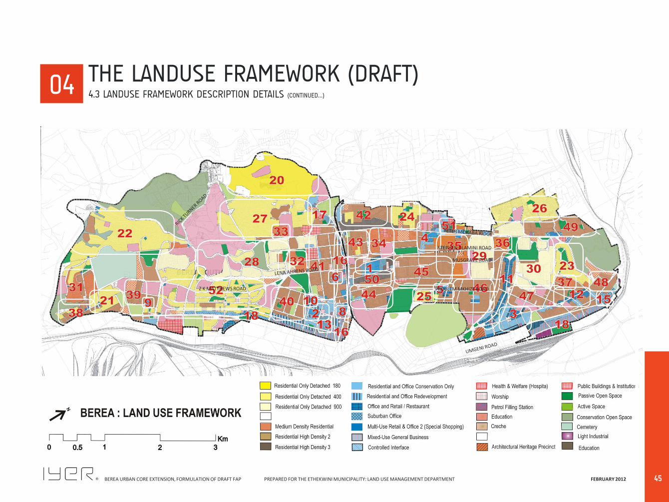
BEREA URBAN CORE EXTENSION, FORMULATION OF DRAFT FAP PREPARED FOR THE ETHEKWINI MUNICIPALITY: LAND USE MANAGEMENT DEPARTMENT FEBRUARY 2012
45
00 04 THE LANDUSE FRAMEWORK (DRAFT)
4.3 LANDUSE FRAMEWORK DESCRIPTION DETAILS (CONTINUED…)
MUSGRAVE ROAD
PROBLEM MKHIZE ROAD Z K MATTHEWS ROAD
STEPHEN DLAMINI ROAD
BEREA URBAN CORE EXTENSION, FORMULATION OF DRAFT FAP PREPARED FOR THE ETHEKWINI MUNICIPALITY: LAND USE MANAGEMENT DEPARTMENT FEBRUARY 2012
46
00 04
AREA AREA TYPE AREA NO AREA DESCRIPTION CURRENT ZONING
(PRIMARY ZONES)
2012 PROPOSALS DESCRIPTION INTENTION
Mixed Use District City-Wide Mixed-Use 1 Musgrave Precinct General Residential 1
General Shopping
MIXED USE DISTRICT COMPRISING:
MULTI-USE RETAIL & OFFICE 1;
GENERAL RESIDENTIAL 3;
RESIDENTIAL & OFFICE
REDEVELOPMENT;
SUBURBAN OFFICE.
This is the largest and highest intensity district of the Berea. At it’s heart
is the Musgrave Shopping centre (a Community level shopping Centre)
and associated retail and office buildings. This node is reasonably fully
developed, with limited opportunity for redevelopment in the central
section; but the northern section has potential for infill redevelopment.
Where redevelopment is feasible it can occur at a higher level of
intensity. Some peripheral clusters will permit additional commercial and
residential uses; but all within the 0.5 km walking Distance.
2 Davenport Precinct General Residential 2
General Shopping 2
MULTI-USE RETAIL & OFFICE 1;
RETAIL AND RESTAURANT
USES;
OFFICE CONVERSION ONLY;
RESIDENTIAL & OFFICE
REDEVELOPMENT;
SUBURBAN OFFICE.
The focus of this district is the Davenport Square shopping centre which
comprises shopping uses with two high-rise blocks of flats above. Office
Conversion Only zones is directed on two sides; while low scale
redevelopment is permitted on Brand Road and Devonshire Avenue. The
upper portion of Helen Joseph Road (Davenport Road) is a small Retail
and Restaurant corridor where development will be orientated to the
street. A fairly substantial area of Office Conversion Only zoning will
occur to one side of the node; while an area between Moore and Clark
Road that is not adjacent to residential development should be
encourage to occur in the form of an “Urban Office” of medium to high-
rise redevelopment that will be constrained at the same level of intensity
as the original GR2 zone i.e. FAR = 1.0.Redevelopment will be restricted
by the large number of listed buildings.
3 Windermere Precinct General Residential 2
General Shopping
Educational 1
MULTI-USE RETAIL & OFFICE 1;
RETAIL AND RESTAURANT
USES;
OFFICE CONVERSION ONLY;
RESIDENTIAL & OFFICE
REDEVELOPMENT.
The focus of this district is the Windermere Neighbourhood level
Shopping Centre which comprises shopping uses with a high-rise block of
flats above. Office Conversion Only is permitted around the shopping
centre A large Office Conversion Only cluster occurs between the centre
and Stamford Hill Road. Redevelopment will be restricted in the Office
Conversion Only area by the large number of listed buildings. The narrow
roads and small sites results in inadequate parking and inconvenient
circulation and will also serve to limit redevelopment.
THE LANDUSE FRAMEWORK (DRAFT) 4.3 LANDUSE FRAMEWORK DESCRIPTION DETAILS (CONTINUED…)

BEREA URBAN CORE EXTENSION, FORMULATION OF DRAFT FAP PREPARED FOR THE ETHEKWINI MUNICIPALITY: LAND USE MANAGEMENT DEPARTMENT FEBRUARY 2012
47
00 04
AREA AREA TYPE AREA NO AREA DESCRIPTION CURRENT ZONING
(Primary Zones)
2012 PROPOSALS DESCRIPTION INTENTION
Mixed Use District City-Wide Mixed-Use 4 Overport Precinct General Shopping
General Residential 1
Maisonette 650
Educational 1
Government & Municipal
MULTI-USE RETAIL & OFFICE 1
GENERAL RESIDENTIAL 3
RESIDENTIAL & OFFICE
REDEVELOPMENT
OFFICE CONVERSION ONLY
SUBURBAN OFFICE
This is a Neighbourhood Shopping Centre based node with an office block
above it. A number of small corner small shopping sites occur adjacent
and across the road from it. This nodes extends from the shopping centre
with a number of houses and older flats converted and redeveloped as
shops and offices. The component parts are not integrated or
coordinated, and the District that is not easily conducive to being
integrated as all four quadrants occur on a busy and awkward
intersection. The node includes a major hospital development with
associated houses and small blocks of flats converted to medical offices.
The district is recommended for further intensification with the addition
of a higher intensity zone for flats.
Berea-Wide Mixed-
Use
5 Cowey Precinct Maisonette 650
General Shopping
General Residential 1
Special Zone
MULTI-USE RETAIL & OFFICE 1;
GENERAL RESIDENTIAL 3;
OFFICE CONVERSION ONLY;
SUBURBAN OFFICE;
SPECIAL ZONE.
This is an older set of commercial developments with inadequate parking
and awkward coordination. It comprises a large Convenience shopping
Centre and individual numerous shops, restaurants and offices in
converted houses and flats extending along Problem Mkhize Road
(Cowey Road) and Marriot Road. This District has become a useful
upgrade and addition to the area and needs to be extended and
coordinated within a shorter walking distance to avoid impacting further
on the integrity of the adjacent residential area.
6 Moore Road Village General Shopping
General Residential 2
Educational
MULTI-USE RETAIL & OFFICE 1;
OFFICE CONVERSION ONLY.
This is a large Convenience shopping/ small neighbourhood level centre
with a large amount of personal services. based node. Extending
outwards from it are both houses and flats converted to offices. The
plan recommends that this district be consolidated within the shorter
walking distance and be investigated for greater integration and
coordination. A major problem is that the older buildings do not provide
adequate parking and this will have to be addressed. It is also the reason
for constraining any further non-residential use invasion. .
THE LANDUSE FRAMEWORK (DRAFT) 4.3 LANDUSE FRAMEWORK DESCRIPTION DETAILS (CONTINUED…)
BEREA URBAN CORE EXTENSION, FORMULATION OF DRAFT FAP PREPARED FOR THE ETHEKWINI MUNICIPALITY: LAND USE MANAGEMENT DEPARTMENT FEBRUARY 2012
48
00 04
AREA AREA TYPE AREA NO AREA DESCRIPTION CURRENT ZONING
(Primary Zones)
2012 PROPOSALS DESCRIPTION INTENTION
Mixed Use District Berea-Wide Mixed-
Use
7 Avondale Centre
District
General Shopping
General Residential 2
MULTI-USE RETAIL & OFFICE 1.
OFFICE CONVERSION ONLY.
This is a Convenience level shopping centre based node based on a
supermarket and a set of restaurants, with some older shops adjacent
and across the road from it. A small amount of office and personal service
uses extend from it. The existing zoned shopping, the existing use rights
site across the road and the office conversion area must be integrated
and constrained from further penetration into the residential area,
especially to maintain the upgraded nature of the area since the advent
of the new ‘Quarters’ Boutique Hotel and restaurant.
8 Berea Centre
District
General Shopping
General Residential 2
Petrol Service Station
Educational 2
General Business 2
MULTI-USE RETAIL & OFFICE
1;
RESIDENTIAL & OFFICE
REDEVELOPMENT;
OFFICE CONVERSION ONLY.
This node comprises the Berea Shopping Centre and associated set of
shops and converted office areas around it. This is also an awkward area
with difficult ingress and egress. This district is also part of the non-
residential strip of uses along the southern edge of Berea Road. The
area forms and adjacent development to the recommended ‘Urban
Office’ zone. The district poses no threat to any adjacent areas as these
are all non-residential in nature. There is no sense of cohesion in this
district and with no particular existing or latent sense of character to
develop upon. Any alteration or redevelopment of uses and buildings
need to take account of traffic movement and parking problems that will
have to be mitigated.
9 Queensmead
District
General Shopping
General Residential 2
Special Residential 650
Maisonette 650
MULTI-USE RETAIL & OFFICE
1;
HIGH DENSITY RESIDENTIAL
2;
OFFICE CONVERSION ONLY.
This node comprises the small neighbourhood level shopping centre and
a small amount of associated office and retail extension. Given its
location at the periphery of the Berea south; the lower threshold of
support of the relatively lower income residents; and the lack of Listed
Buildings, there has been no demand for any extension or elaboration of
this node. It will remain essentially a mono-use shopping facility.
THE LANDUSE FRAMEWORK (DRAFT) 4.3 LANDUSE FRAMEWORK DESCRIPTION DETAILS (CONTINUED…)
BEREA URBAN CORE EXTENSION, FORMULATION OF DRAFT FAP PREPARED FOR THE ETHEKWINI MUNICIPALITY: LAND USE MANAGEMENT DEPARTMENT FEBRUARY 2012
49
00 04
AREA AREA TYPE AREA NO AREA DESCRIPTION CURRENT ZONING
(Primary Zones)
2012 PROPOSALS DESCRIPTION INTENTION
Mixed-Use
Corridor
City-Wide
Entertainment
Corridor
10 Helen Joseph Road
(Davenport Road)
General Residential 2
General Shopping
RESTAURANT AND RETAIL
REDEVELOPMENT;
MULTI-USE RETAIL AND
OFFICES.
This is a short well developed linear belt that is part of the Davenport
Mixed-Use District. It has evolved into a mainly restaurant cluster,
where almost all the houses are already converted to non-residential
uses. The proposal is to substantiate and reinforce this and encourage
the developments to relate to the pedestrian street that has already
occurred. The issue of parking coordination between the developments
needs to be investigated; as well as reinforcing the pedestrian quantity
and expansion of ‘al fresco’ dining. The new zoning system will make
use of an Urban design Management Overlay to direct development.
11 Florida Road General Residential1
General Residential 2
General Shopping
Special Zone
Maisonenette 900
RESTAURANT AND RETAIL
REDEVELOPMENT;
MULTI-USE RETAIL AND
OFFICES.
This corridor is a differentiated strip of restaurant, retail, office and
residential clusters that comprise of many existing listed shops and
houses and flats. It has become a well developed entertainment and
tourist precinct, mostly at a level of single and double storey
developments. The character of the area needs to be conserved so that
any new development must be in alignment with the existing
development. Shops and restaurants should be encouraged to relate to
the street. This area needs protection and appropriate interventions to
reinforce and beneficiate the evolved character. The new zoning
typology will set the base for this intention, and an Urban Design
Management Overlay must be developed to direct development
together with appropriate Municipal interventions. A substantial
amount of residential development is still in place and these
developments and adjacent areas need to be protected from
externalities. Given the pedestrian nature of the area there is a need to
consider ‘Traffic Calming’ interventions in appropriate areas.
Berea-Wide Corridor 12 Lilian Ngoyi Road
(Windermere Road)
General Shopping
General Residential 2
General Residential 1
Maisonette 650
Educational 2
RESTAURANT AND RETAIL
REDEVELOPMENT;
MULTI-USE RETAIL AND
OFFICES.
This corridor is a series of clusters along the corridor comprising shops,
restaurants offices and residual residential development, largely
occurring as flats. This is a latent corridor as it also not a continuous
corridor. There is no distinct character for any of the clusters. A role and
character needs to be established. Consideration must be given to
consolidating a walking distance based cluster to consolidate before
‘spot-zoning’ type leap-frogging destroys any cohesion. In due course
this area will also require an Urban design Management in order to
implement this incipient corridor.
THE LANDUSE FRAMEWORK (DRAFT) 4.3 LANDUSE FRAMEWORK DESCRIPTION DETAILS (CONTINUED…)
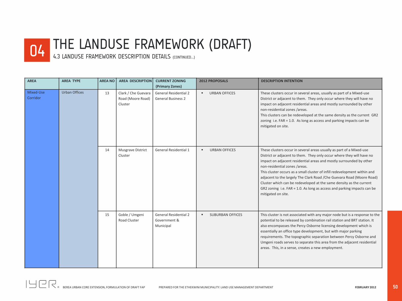
BEREA URBAN CORE EXTENSION, FORMULATION OF DRAFT FAP PREPARED FOR THE ETHEKWINI MUNICIPALITY: LAND USE MANAGEMENT DEPARTMENT FEBRUARY 2012
50
00 04
AREA AREA TYPE AREA NO AREA DESCRIPTION CURRENT ZONING
(Primary Zones)
2012 PROPOSALS DESCRIPTION INTENTION
Mixed-Use
Corridor
Urban Offices 13 Clark / Che Guevara
Road (Moore Road)
Cluster
General Residential 2
General Business 2
URBAN OFFICES These clusters occur in several areas, usually as part of a Mixed-use
District or adjacent to them. They only occur where they will have no
impact on adjacent residential areas and mostly surrounded by other
non-residential zones /areas.
This clusters can be redeveloped at the same density as the current GR2
zoning i.e. FAR = 1.0. As long as access and parking impacts can be
mitigated on site.
14 Musgrave District
Cluster
General Residential 1 URBAN OFFICES These clusters occur in several areas usually as part of a Mixed-use
District or adjacent to them. They only occur where they will have no
impact on adjacent residential areas and mostly surrounded by other
non-residential zones /areas.
This cluster occurs as a small cluster of infill redevelopment within and
adjacent to the largely The Clark Road /Che Guevara Road (Moore Road)
Cluster which can be redeveloped at the same density as the current
GR2 zoning i.e. FAR = 1.0. As long as access and parking impacts can be
mitigated on site.
15 Goble / Umgeni
Road Cluster
General Residential 2
Government &
Municipal
SUBURBAN OFFICES This cluster is not associated with any major node but is a response to the
potential to be released by combination rail station and BRT station. It
also encompasses the Percy Osborne licensing development which is
essentially an office type development, but with major parking
requirements. The topographic separation between Percy Osborne and
Umgeni roads serves to separate this area from the adjacent residential
areas. This, in a sense, creates a new employment.
THE LANDUSE FRAMEWORK (DRAFT) 4.3 LANDUSE FRAMEWORK DESCRIPTION DETAILS (CONTINUED…)

BEREA URBAN CORE EXTENSION, FORMULATION OF DRAFT FAP PREPARED FOR THE ETHEKWINI MUNICIPALITY: LAND USE MANAGEMENT DEPARTMENT FEBRUARY 2012
51
00 04
AREA AREA TYPE AREA NO AREA DESCRIPTION CURRENT ZONING
(Primary Zones)
2012 PROPOSALS DESCRIPTION INTENTION
Mixed-Use
Corridor
Berea Road 16 General Residential 2
Special Shopping
Educational 2
General Residential 1
Special Zone
A series of Zones
MIXED-USE GENERAL
BUSINESS at the lower end;
PETROL FILLING STATION;
MULTI-USE RETAIL AND
OFFICES 1 (Berea Centre);
RESIDENTIAL HIGH DENSITY
2 – several clusters up the
road;
MULTI-USE RETAIL AND
OFFICES 2 (Food Market and
in several clusters including
at intersections of Cato and
Chelmsford);
URBAN OFFICES (Kuhn &
Nagle);
EDUCATIONAL;
PETROL FILLING STATION
and RESIDENTIAL AND
OFFICE REDEVELOPMENT
between Chelmsford and
Peter Mokaba Ridge (Ridge
Road).
This is a mixed-use linear belt of sites that take direct access off the
southern side of Berea Road. The belt comprises several zones along its
length. The zones vary according to the section of Berea Road and the
nature of uses /zones behind them. These serve different forms of
passing traffic and none are large enough to become nodes in the true
sense of the meaning.
Westridge 17 General Residential 1
General Shopping
Government &
Municipal
Special Shopping
Special Residential 650
HIGH DENSITY RESIDENTIAL
2;
URBAN OFFICES;
HEALTH & WELFARE;
EDUCATIONAL;
PUBLIC BUILDINGS & GOVT;
RESIDENTIAL AND OFFICE
CONSERVATION ONLY
This area comprises a range of unrelated non-residential uses that do
result in the form of a Node in the true sense. These uses occur along a
major transport route that is not conducive to residential development.
The area comprises shops, high rise offices, the Oncology unit, Damelin
University, a Police Station, and the older cluster of small houses now
largely converted to Business Offices.
THE LANDUSE FRAMEWORK (DRAFT) 4.3 LANDUSE FRAMEWORK DESCRIPTION DETAILS (CONTINUED…)
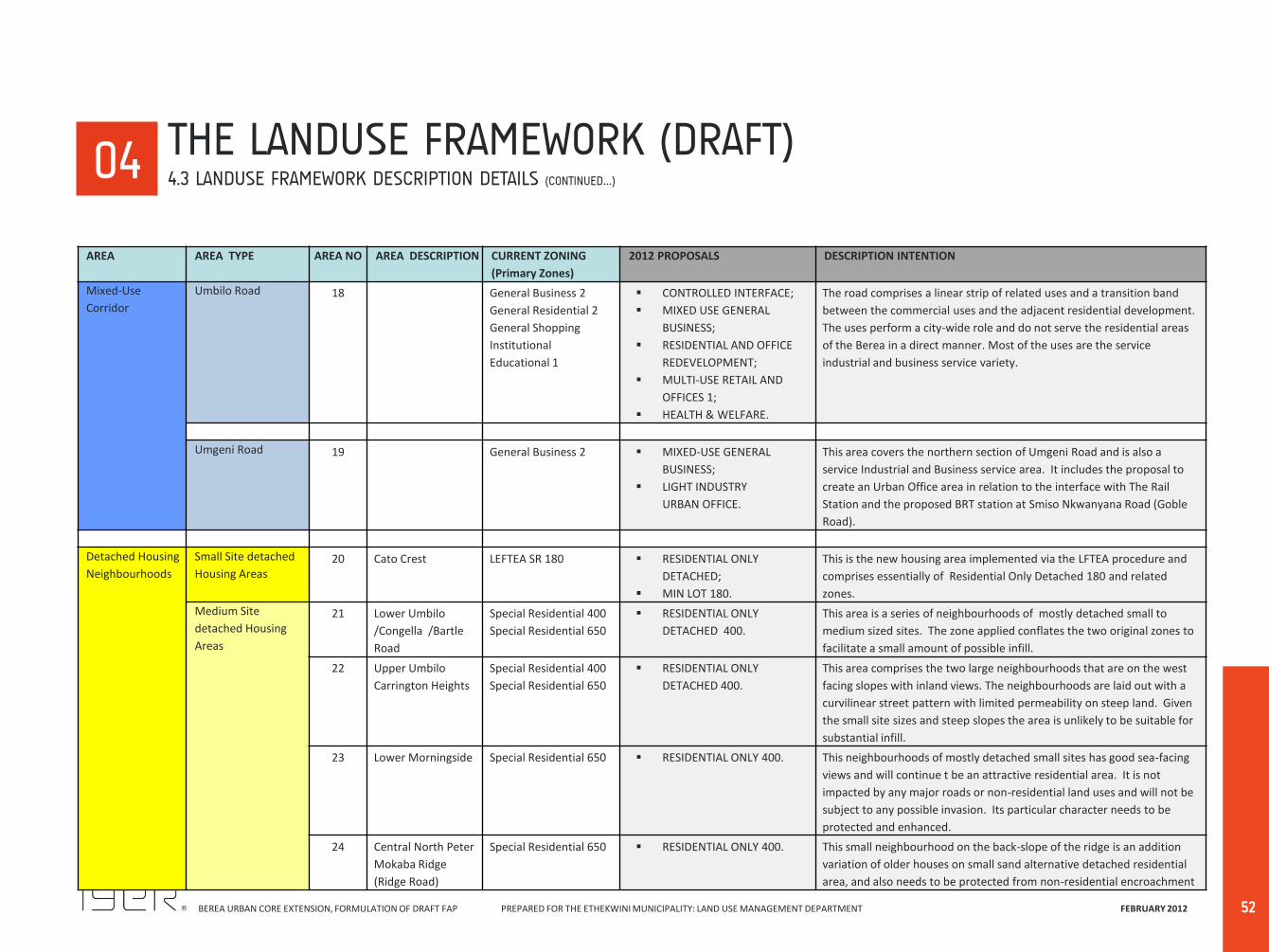
BEREA URBAN CORE EXTENSION, FORMULATION OF DRAFT FAP PREPARED FOR THE ETHEKWINI MUNICIPALITY: LAND USE MANAGEMENT DEPARTMENT FEBRUARY 2012
52
00 04
AREA AREA TYPE AREA NO AREA DESCRIPTION CURRENT ZONING
(Primary Zones)
2012 PROPOSALS DESCRIPTION INTENTION
Mixed-Use
Corridor
Umbilo Road 18 General Business 2
General Residential 2
General Shopping
Institutional
Educational 1
CONTROLLED INTERFACE;
MIXED USE GENERAL
BUSINESS;
RESIDENTIAL AND OFFICE
REDEVELOPMENT;
MULTI-USE RETAIL AND
OFFICES 1;
HEALTH & WELFARE.
The road comprises a linear strip of related uses and a transition band
between the commercial uses and the adjacent residential development.
The uses perform a city-wide role and do not serve the residential areas
of the Berea in a direct manner. Most of the uses are the service
industrial and business service variety.
Umgeni Road 19 General Business 2 MIXED-USE GENERAL
BUSINESS;
LIGHT INDUSTRY
URBAN OFFICE.
This area covers the northern section of Umgeni Road and is also a
service Industrial and Business service area. It includes the proposal to
create an Urban Office area in relation to the interface with The Rail
Station and the proposed BRT station at Smiso Nkwanyana Road (Goble
Road).
Detached Housing
Neighbourhoods
Small Site detached
Housing Areas 20 Cato Crest LEFTEA SR 180 RESIDENTIAL ONLY
DETACHED;
MIN LOT 180.
This is the new housing area implemented via the LFTEA procedure and
comprises essentially of Residential Only Detached 180 and related
zones.
Medium Site
detached Housing
Areas
21 Lower Umbilo
/Congella /Bartle
Road
Special Residential 400
Special Residential 650
RESIDENTIAL ONLY
DETACHED 400.
This area is a series of neighbourhoods of mostly detached small to
medium sized sites. The zone applied conflates the two original zones to
facilitate a small amount of possible infill.
22 Upper Umbilo
Carrington Heights
Special Residential 400
Special Residential 650
RESIDENTIAL ONLY
DETACHED 400.
This area comprises the two large neighbourhoods that are on the west
facing slopes with inland views. The neighbourhoods are laid out with a
curvilinear street pattern with limited permeability on steep land. Given
the small site sizes and steep slopes the area is unlikely to be suitable for
substantial infill.
23 Lower Morningside Special Residential 650 RESIDENTIAL ONLY 400. This neighbourhoods of mostly detached small sites has good sea-facing
views and will continue t be an attractive residential area. It is not
impacted by any major roads or non-residential land uses and will not be
subject to any possible invasion. Its particular character needs to be
protected and enhanced.
24 Central North Peter
Mokaba Ridge
(Ridge Road)
Special Residential 650 RESIDENTIAL ONLY 400. This small neighbourhood on the back-slope of the ridge is an addition
variation of older houses on small sand alternative detached residential
area, and also needs to be protected from non-residential encroachment
THE LANDUSE FRAMEWORK (DRAFT) 4.3 LANDUSE FRAMEWORK DESCRIPTION DETAILS (CONTINUED…)
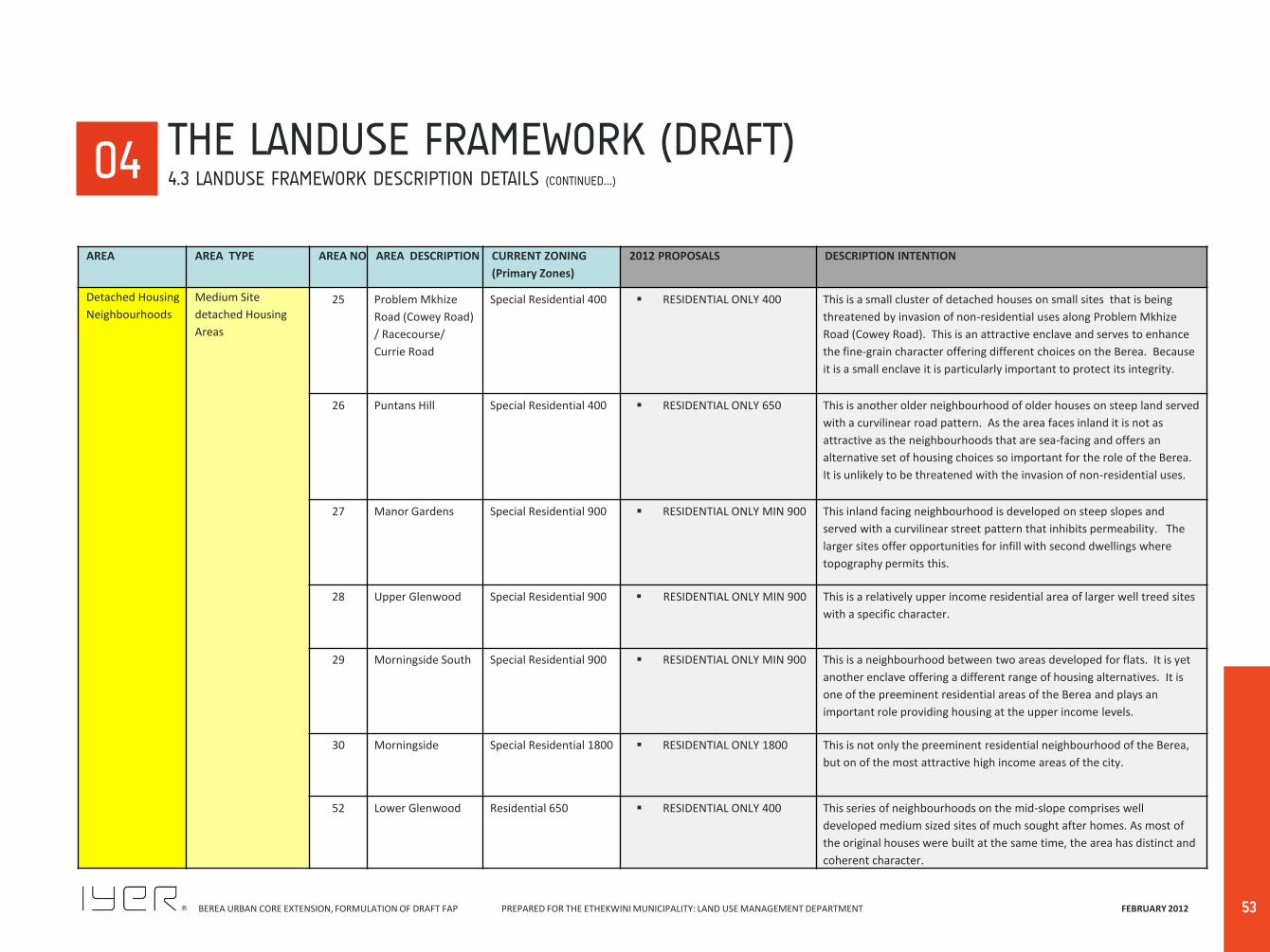
BEREA URBAN CORE EXTENSION, FORMULATION OF DRAFT FAP PREPARED FOR THE ETHEKWINI MUNICIPALITY: LAND USE MANAGEMENT DEPARTMENT FEBRUARY 2012
53
00 04
AREA AREA TYPE AREA NO AREA DESCRIPTION CURRENT ZONING
(Primary Zones)
2012 PROPOSALS DESCRIPTION INTENTION
Detached Housing
Neighbourhoods
Medium Site
detached Housing
Areas
25 Problem Mkhize
Road (Cowey Road)
/ Racecourse/
Currie Road
Special Residential 400 RESIDENTIAL ONLY 400 This is a small cluster of detached houses on small sites that is being
threatened by invasion of non-residential uses along Problem Mkhize
Road (Cowey Road). This is an attractive enclave and serves to enhance
the fine-grain character offering different choices on the Berea. Because
it is a small enclave it is particularly important to protect its integrity.
26 Puntans Hill Special Residential 400 RESIDENTIAL ONLY 650 This is another older neighbourhood of older houses on steep land served
with a curvilinear road pattern. As the area faces inland it is not as
attractive as the neighbourhoods that are sea-facing and offers an
alternative set of housing choices so important for the role of the Berea.
It is unlikely to be threatened with the invasion of non-residential uses.
27 Manor Gardens Special Residential 900 RESIDENTIAL ONLY MIN 900 This inland facing neighbourhood is developed on steep slopes and
served with a curvilinear street pattern that inhibits permeability. The
larger sites offer opportunities for infill with second dwellings where
topography permits this.
28 Upper Glenwood Special Residential 900 RESIDENTIAL ONLY MIN 900 This is a relatively upper income residential area of larger well treed sites
with a specific character.
29 Morningside South Special Residential 900 RESIDENTIAL ONLY MIN 900 This is a neighbourhood between two areas developed for flats. It is yet
another enclave offering a different range of housing alternatives. It is
one of the preeminent residential areas of the Berea and plays an
important role providing housing at the upper income levels.
30 Morningside Special Residential 1800 RESIDENTIAL ONLY 1800 This is not only the preeminent residential neighbourhood of the Berea,
but on of the most attractive high income areas of the city.
52 Lower Glenwood Residential 650 RESIDENTIAL ONLY 400 This series of neighbourhoods on the mid-slope comprises well
developed medium sized sites of much sought after homes. As most of
the original houses were built at the same time, the area has distinct and
coherent character.
THE LANDUSE FRAMEWORK (DRAFT) 4.3 LANDUSE FRAMEWORK DESCRIPTION DETAILS (CONTINUED…)
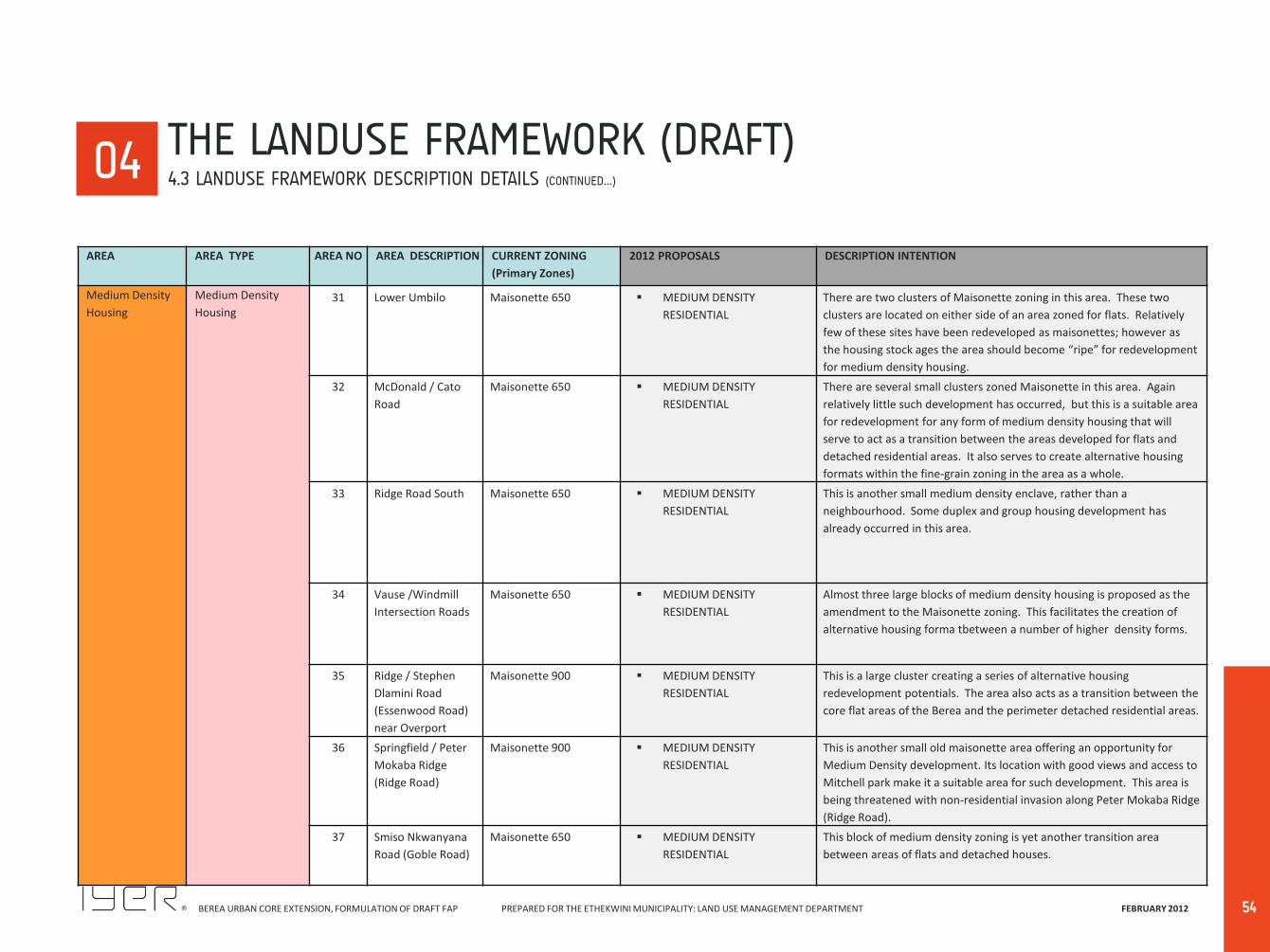
BEREA URBAN CORE EXTENSION, FORMULATION OF DRAFT FAP PREPARED FOR THE ETHEKWINI MUNICIPALITY: LAND USE MANAGEMENT DEPARTMENT FEBRUARY 2012
54
00 04
AREA AREA TYPE AREA NO AREA DESCRIPTION CURRENT ZONING
(Primary Zones)
2012 PROPOSALS DESCRIPTION INTENTION
Medium Density
Housing
Medium Density
Housing 31 Lower Umbilo Maisonette 650 MEDIUM DENSITY
RESIDENTIAL
There are two clusters of Maisonette zoning in this area. These two
clusters are located on either side of an area zoned for flats. Relatively
few of these sites have been redeveloped as maisonettes; however as
the housing stock ages the area should become “ripe” for redevelopment
for medium density housing.
32 McDonald / Cato
Road
Maisonette 650 MEDIUM DENSITY
RESIDENTIAL
There are several small clusters zoned Maisonette in this area. Again
relatively little such development has occurred, but this is a suitable area
for redevelopment for any form of medium density housing that will
serve to act as a transition between the areas developed for flats and
detached residential areas. It also serves to create alternative housing
formats within the fine-grain zoning in the area as a whole.
33 Ridge Road South Maisonette 650 MEDIUM DENSITY
RESIDENTIAL
This is another small medium density enclave, rather than a
neighbourhood. Some duplex and group housing development has
already occurred in this area.
34 Vause /Windmill
Intersection Roads
Maisonette 650 MEDIUM DENSITY
RESIDENTIAL
Almost three large blocks of medium density housing is proposed as the
amendment to the Maisonette zoning. This facilitates the creation of
alternative housing forma tbetween a number of higher density forms.
35 Ridge / Stephen
Dlamini Road
(Essenwood Road)
near Overport
Maisonette 900 MEDIUM DENSITY
RESIDENTIAL
This is a large cluster creating a series of alternative housing
redevelopment potentials. The area also acts as a transition between the
core flat areas of the Berea and the perimeter detached residential areas.
36 Springfield / Peter
Mokaba Ridge
(Ridge Road)
Maisonette 900 MEDIUM DENSITY
RESIDENTIAL
This is another small old maisonette area offering an opportunity for
Medium Density development. Its location with good views and access to
Mitchell park make it a suitable area for such development. This area is
being threatened with non-residential invasion along Peter Mokaba Ridge
(Ridge Road).
37 Smiso Nkwanyana
Road (Goble Road)
Maisonette 650 MEDIUM DENSITY
RESIDENTIAL
This block of medium density zoning is yet another transition area
between areas of flats and detached houses.
THE LANDUSE FRAMEWORK (DRAFT) 4.3 LANDUSE FRAMEWORK DESCRIPTION DETAILS (CONTINUED…)
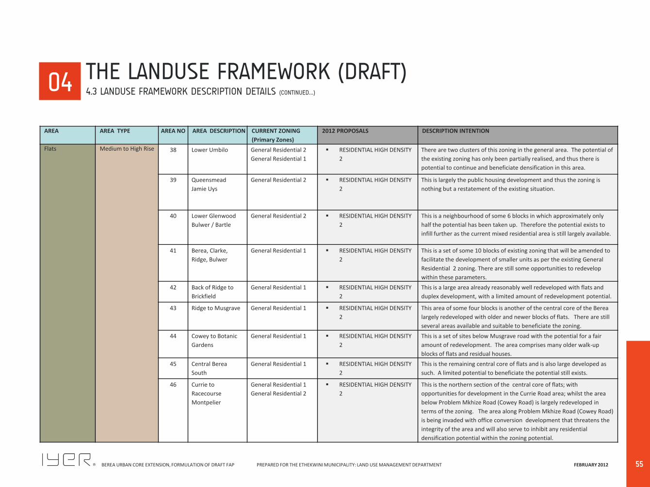
BEREA URBAN CORE EXTENSION, FORMULATION OF DRAFT FAP PREPARED FOR THE ETHEKWINI MUNICIPALITY: LAND USE MANAGEMENT DEPARTMENT FEBRUARY 2012
55
00 04
AREA AREA TYPE AREA NO AREA DESCRIPTION CURRENT ZONING
(Primary Zones)
2012 PROPOSALS DESCRIPTION INTENTION
Flats Medium to High Rise 38 Lower Umbilo General Residential 2
General Residential 1
RESIDENTIAL HIGH DENSITY
2
There are two clusters of this zoning in the general area. The potential of
the existing zoning has only been partially realised, and thus there is
potential to continue and beneficiate densification in this area.
39 Queensmead
Jamie Uys
General Residential 2 RESIDENTIAL HIGH DENSITY
2
This is largely the public housing development and thus the zoning is
nothing but a restatement of the existing situation.
40 Lower Glenwood
Bulwer / Bartle
General Residential 2 RESIDENTIAL HIGH DENSITY
2
This is a neighbourhood of some 6 blocks in which approximately only
half the potential has been taken up. Therefore the potential exists to
infill further as the current mixed residential area is still largely available.
41 Berea, Clarke,
Ridge, Bulwer
General Residential 1 RESIDENTIAL HIGH DENSITY
2
This is a set of some 10 blocks of existing zoning that will be amended to
facilitate the development of smaller units as per the existing General
Residential 2 zoning. There are still some opportunities to redevelop
within these parameters.
42 Back of Ridge to
Brickfield
General Residential 1 RESIDENTIAL HIGH DENSITY
2
This is a large area already reasonably well redeveloped with flats and
duplex development, with a limited amount of redevelopment potential.
43 Ridge to Musgrave General Residential 1 RESIDENTIAL HIGH DENSITY
2
This area of some four blocks is another of the central core of the Berea
largely redeveloped with older and newer blocks of flats. There are still
several areas available and suitable to beneficiate the zoning.
44 Cowey to Botanic
Gardens
General Residential 1 RESIDENTIAL HIGH DENSITY
2
This is a set of sites below Musgrave road with the potential for a fair
amount of redevelopment. The area comprises many older walk-up
blocks of flats and residual houses.
45 Central Berea
South
General Residential 1 RESIDENTIAL HIGH DENSITY
2
This is the remaining central core of flats and is also large developed as
such. A limited potential to beneficiate the potential still exists.
46 Currie to
Racecourse
Montpelier
General Residential 1
General Residential 2
RESIDENTIAL HIGH DENSITY
2
This is the northern section of the central core of flats; with
opportunities for development in the Currie Road area; whilst the area
below Problem Mkhize Road (Cowey Road) is largely redeveloped in
terms of the zoning. The area along Problem Mkhize Road (Cowey Road)
is being invaded with office conversion development that threatens the
integrity of the area and will also serve to inhibit any residential
densification potential within the zoning potential.
THE LANDUSE FRAMEWORK (DRAFT) 4.3 LANDUSE FRAMEWORK DESCRIPTION DETAILS (CONTINUED…)
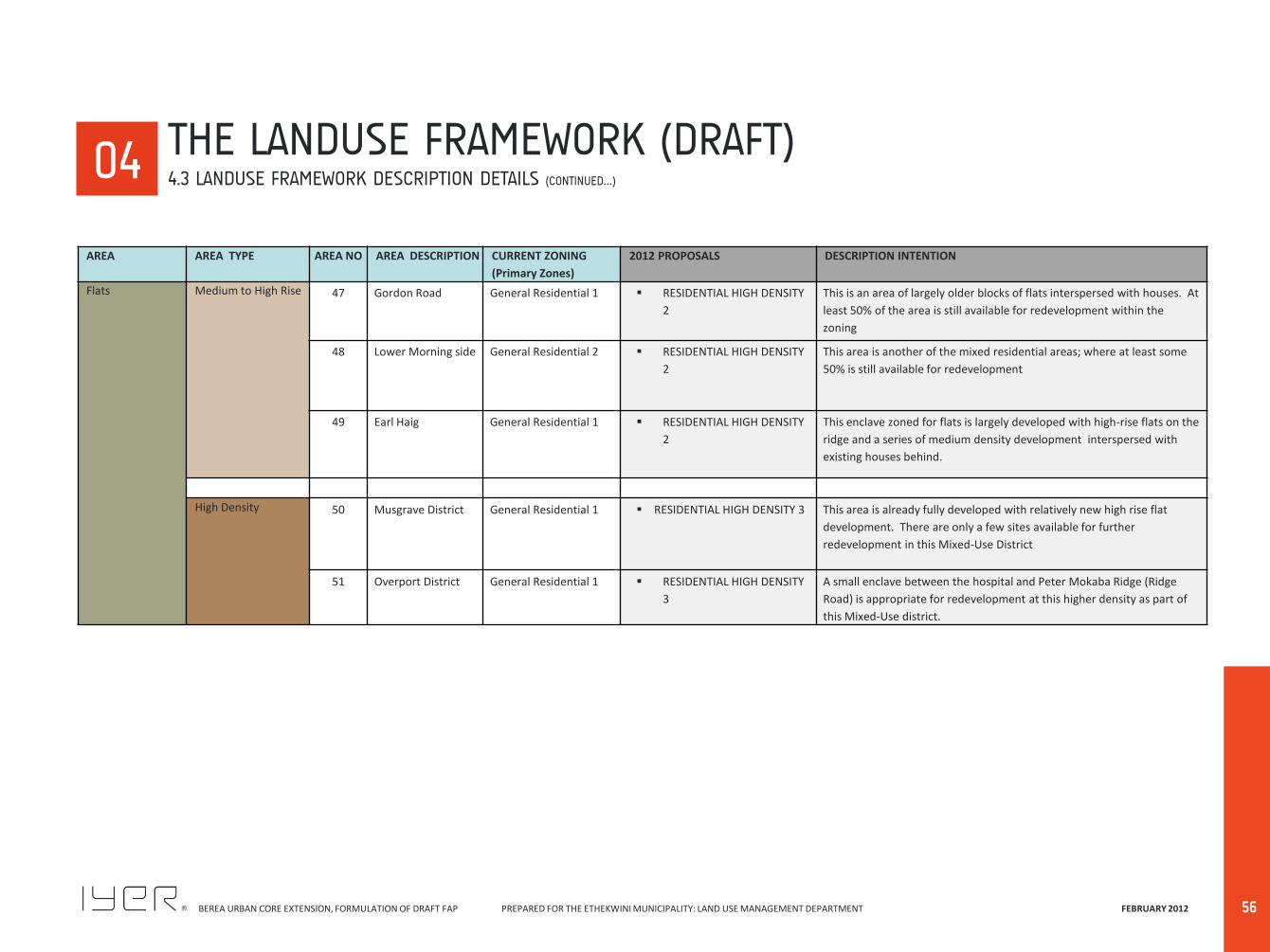
BEREA URBAN CORE EXTENSION, FORMULATION OF DRAFT FAP PREPARED FOR THE ETHEKWINI MUNICIPALITY: LAND USE MANAGEMENT DEPARTMENT FEBRUARY 2012
56
00 04
AREA AREA TYPE AREA NO AREA DESCRIPTION CURRENT ZONING
(Primary Zones)
2012 PROPOSALS DESCRIPTION INTENTION
Flats Medium to High Rise 47 Gordon Road General Residential 1 RESIDENTIAL HIGH DENSITY
2
This is an area of largely older blocks of flats interspersed with houses. At
least 50% of the area is still available for redevelopment within the
zoning
48 Lower Morning side General Residential 2 RESIDENTIAL HIGH DENSITY
2
This area is another of the mixed residential areas; where at least some
50% is still available for redevelopment
49 Earl Haig General Residential 1 RESIDENTIAL HIGH DENSITY
2
This enclave zoned for flats is largely developed with high-rise flats on the
ridge and a series of medium density development interspersed with
existing houses behind.
High Density 50 Musgrave District General Residential 1 RESIDENTIAL HIGH DENSITY 3 This area is already fully developed with relatively new high rise flat
development. There are only a few sites available for further
redevelopment in this Mixed-Use District
51 Overport District General Residential 1 RESIDENTIAL HIGH DENSITY
3
A small enclave between the hospital and Peter Mokaba Ridge (Ridge
Road) is appropriate for redevelopment at this higher density as part of
this Mixed-Use district.
THE LANDUSE FRAMEWORK (DRAFT) 4.3 LANDUSE FRAMEWORK DESCRIPTION DETAILS (CONTINUED…)

BEREA URBAN CORE EXTENSION, FORMULATION OF DRAFT FAP PREPARED FOR THE ETHEKWINI MUNICIPALITY: LAND USE MANAGEMENT DEPARTMENT FEBRUARY 2012
57
00 04 THE LANDUSE FRAMEWORK (DRAFT)
4.4 THE DRAFT LANDUSE FRAMEWORK
MUSGRAVE ROAD
PROBLEM MKHIZE ROAD Z K MATTHEWS ROAD
STEPHEN DLAMINI ROAD

BEREA URBAN CORE EXTENSION, FORMULATION OF DRAFT FAP PREPARED FOR THE ETHEKWINI MUNICIPALITY: LAND USE MANAGEMENT DEPARTMENT FEBRUARY 2012
58
BEREA URBAN CORE EXTENSION, FORMULATION OF DRAFT FAP PREPARED FOR THE ETHEKWINI MUNICIPALITY: LAND USE MANAGEMENT DEPARTMENT FEBRUARY 2012
IMPLEMENTATION PLAN
05

BEREA URBAN CORE EXTENSION, FORMULATION OF DRAFT FAP PREPARED FOR THE ETHEKWINI MUNICIPALITY: LAND USE MANAGEMENT DEPARTMENT FEBRUARY 2012
60

BEREA URBAN CORE EXTENSION, FORMULATION OF DRAFT FAP PREPARED FOR THE ETHEKWINI MUNICIPALITY: LAND USE MANAGEMENT DEPARTMENT FEBRUARY 2012
61
00 05 IMPLEMENTATION PLAN
5.1 THE APPROACH
The purpose of the Implementation Framework is the identification of the different types of planning interventions, primarily those that need to address pressures for change in terms of the requirement to redress the need for ‘improvement’; and additional or new aspects; and those that are, or could be, strategic catalysts for initiating change and a response from the private sector. The following table sets up the framework for the implementation plant, which will be detailed in the forthcoming phase of the project. 5.1 THE APPROACH The following outlines some of the development approaches underlying the Implementation Framework: i. Responding to Development pressures This requires addressing areas subject to both growth and change. It also means being mindful of the Vision and the Land Use Framework that identifies the unique nature of the different components of the area. Promoting a Sustainable development sequence This requires facilitating a development process which is based on a geographical, economic and servicing logic which improves the living conditions of the local residents, contributing to maintaining a variety of living options within the Berea and which maintains the specific character of the various parts of the Berea ii. Retaining the unique character of the area This requires promoting the maintenance, rehabilitation, protection and management of the different parts of the Berea such as to integrate the various parts, especially the various Mixed-Use.
iii. Improving living conditions This requires supporting the provision of adequate and appropriate physical and social services, local economic development and the maintenance of the natural environment. iv. Ensuring sustainable development, This includes environmental as well as economic, social, institutional etc sustainability. v. Supporting appropriate local economic development This requires facilitating the creation of an appropriate local economy linked into the wider metropolitan area by recognizing City-wide, Berea-wide and local Neighbourhood systems and opportunities., while still improving local living conditions. vi. Creating development management capacity This requires establishing capacities and capabilities at the Municipal local level, allowing for the promotion and management of the appropriate development of the area; as well as creating a local understanding and involvement in the development process. vii. Ensuring availability of appropriate physical and social
services This requires guiding development such as to enable the municipality and other service providers to establish adequate physical and social support services. viii. Positively integrating the natural into the built
environment This requires maintaining the unique character of the various components of the Berea, the integration of the natural environment as a positive part of the built environment so
that it becomes an essential development approach to be appropriately promoted and managed.
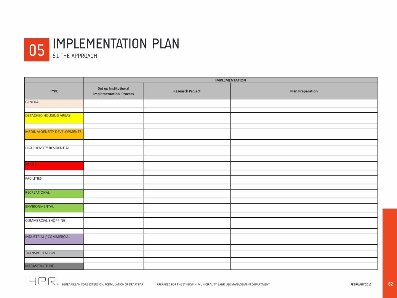
BEREA URBAN CORE EXTENSION, FORMULATION OF DRAFT FAP PREPARED FOR THE ETHEKWINI MUNICIPALITY: LAND USE MANAGEMENT DEPARTMENT FEBRUARY 2012
62
IMPLEMENTATION
TYPE Set up Institutional
Implementation Process Research Project Plan Preparation
GENERAL
DETACHED HOUSING AREAS
MEDIUM DENSITY DEVELOPMENTS
HIGH DENSITY RESIDENTIAL
NODES
FACILITIES
RECREATIONAL
ENVIRONMENTAL
COMMERCIAL SHOPPING
INDUSTRIAL / COMMERCIAL
TRANSPORTATION
INFRASTRUCTURE
00 05 IMPLEMENTATION PLAN
5.1 THE APPROACH