Embed Size (px)
Citation preview

Best practices for creating new salt marshes in an estuarine setting, a literature study
2 of 39 Report number C145/12
EcoShape – Building with Nature
Project: OK0.3 Marconi Delfzijl
Rapport titel: Best practices for creating new salt marshes in a saline estuarine setting, a literature study
Rapport nummer: Auteurs:
IMARES C145/12 A.V. de Groot W.E. van Duin
Project manager:
M.J. Baptist (IMARES)
Datum: 14 January 2013
Versie: 1.0
Report number C145/12 3 of 39
IMARES is: • an independent, objective and authoritative institute that provides knowledge necessary for an
integrated sustainable protection, exploitation and spatial use of the sea and coastal zones; • an institute that provides knowledge necessary for an integrated sustainable protection, exploitation
and spatial use of the sea and coastal zones; • a key, proactive player in national and international marine networks (including ICES and EFARO).
P.O. Box 68 P.O. Box 77 P.O. Box 57 P.O. Box 167
1970 AB IJmuiden 4400 AB Yerseke 1780 AB Den Helder 1790 AD Den Burg Texel
Phone: +31 (0)317 48 09 00 Phone: +31 (0)317 48 09 00 Phone: +31 (0)317 48 09 00 Phone: +31 (0)317 48 09 00
Fax: +31 (0)317 48 73 26 Fax: +31 (0)317 48 73 59 Fax: +31 (0)223 63 06 87 Fax: +31 (0)317 48 73 62
E-Mail: [email protected] E-Mail: [email protected] E-Mail: [email protected] E-Mail: [email protected]
www.imares.wur.nl www.imares.wur.nl www.imares.wur.nl www.imares.wur.nl
© 2012 IMARES Wageningen UR IMARES, institute of Stichting DLO is registered in the Dutch trade record nr. 09098104, BTW nr. NL 806511618
The Management of IMARES is not responsible for resulting damage, as well as for damage resulting from the application of results or research obtained by IMARES, its clients or any claims related to the application of information found within its research. This report has been made on the request of the client and is wholly the client's property. This report may not be reproduced and/or published partially or in its entirety without the express written consent of the client.
A_4_3_2-V12.5
4 of 39 Report number C145/12
Contents
Contents ................................................................................................................... 4
Summary ................................................................................................................. 5
Nederlandse samenvatting .......................................................................................... 7
1 Introduction ..................................................................................................... 8 1.1 The Marconi project ................................................................................. 8 1.2 Aim .................................................................................................... 9 1.3 Approach ................................................................................................ 9
2 The situation at Delfzijl .................................................................................... 10
3 Processes and factors ...................................................................................... 13 3.1 Natural salt-marsh functioning ................................................................. 13 3.2 Salt-marsh types from which information was derived ................................. 14 3.3 Elevation and tidal range ........................................................................ 16 3.4 Hydrodynamics ...................................................................................... 17 3.5 Drainage .............................................................................................. 18 3.6 Sedimentation ....................................................................................... 19 3.7 Salt-marsh sediment .............................................................................. 20 3.8 Vegetation ............................................................................................ 21 3.9 Fauna .................................................................................................. 23
4 Techniques and management for creating salt marshes ........................................ 24 4.1 Techniques for creating salt marshes ........................................................ 24 4.2 Monitoring ............................................................................................ 25 4.3 Success of (re)created salt marshes ......................................................... 25
5 Application at Delfzijl ....................................................................................... 27 5.1 Conditions for salt marshes at Delfzijl ....................................................... 27 5.2 Pioneer salt marsh ................................................................................. 28 5.3 Salt-marsh park .................................................................................... 29 5.4 Naturalness and nature values ................................................................. 29 5.5 Aspects not taken into account ................................................................ 30
6 Conclusions .................................................................................................... 31 6.1 Factors of importance when creating a salt marsh ...................................... 31 6.2 Most suitable methods for creating a new salt marsh at this location ............. 31
Report number C145/12 5 of 39
6.3 What naturalness and nature values can be achieved, and how .................... 32
Acknowledgements .................................................................................................. 32
References .............................................................................................................. 33
Supplement 1 .......................................................................................................... 38
Justification ............................................................................................................. 39
6 of 39 Report number C145/12
Summary At Delfzijl, one of the main aims of the Marconi project is developing two new salt marshes. One (the ‘salt-marsh park’) is meant for recreation, and the second (‘pioneer salt marsh’) will have a function for coastal protection and nature. The present literature study gives information on various aspects of salt-marsh restoration, needed for, and used in, the design process. This is based on literature on a variety of natural saltmarshes and existing salt-marsh (re)creation projects, and has the Building with Nature philosophy as background. Creating or restoring a salt marsh requires (re)creating the boundary conditions for natural salt-marsh development. Only then may the functioning and nature values of a (re)created salt marsh approach those of a natural salt marsh. It seems possible to create a salt marsh at Delfzijl, as tidal range, vegetation and suspended sediment are suitable for the occurrence of salt marshes. However, the elevation of the intertidal and subtidal area needs to be raised to around mean high water, for example with dredged material. Further, the hydrodynamics need to be diminished. A suitable method is using brushwood groynes, given their flexibility and local cultural history. For the salt-marsh park, harder constructions such as stone dams may be needed. Digging drainage channels does not seem to be necessary, and vegetation is expected to spontaneously disperse to the sites because of sufficient source material present in the area. Depending on the desired functioning of the salt marsh, some form of vegetation management may be needed, such as mowing or grazing. As soon as the elevation of the area is suitable and shelter has been created, the area is expected to colonise rapidly with vegetation and show vertical accretion. It will most likely become a semi-natural salt marsh only, as full salt-marsh functioning is almost never reached in a reconstructed salt marsh. What may be expected, though, is the presence of various typical salt-marsh plants, a location for birds to rest at high tide and on the higher parts possible breeding of birds. Objectives for the project need to be set, to direct both the design process and the monitoring strategy. The project needs to be monitored carefully to evaluate whether the set objectives are met so that management can be adapted if needed.
Report number C145/12 7 of 39
Nederlandse samenvatting Het Marconi project bij Delfzijl heeft als één van haar doelen het ontwikkelen van nieuwe kwelders bij Delfzijl. De eerste (‘kwelderpark’) heeft als hoofdfunctie recreatie, en de tweede (‘pionierkwelder’) heeft als hoofddoelen kustbescherming en natuur. Deze literatuurstudie geeft informatie over het kwelderherstel en de kwelderaanleg nodig voor het ontwerpproces. Het is gebaseerd op literatuur over verschillende aangelegde en herstelde kwelders wereldwijd, en heeft de Building with Nature filosofie als achtergrond. Voor het aanleggen of herstellen van een kwelder is het nodig om de randvoorwaarden voor de natuurlijke processen in orde te brengen, zodat kwelderontwikkeling plaats kan vinden. Alleen dan kan een aangelegde kwelder qua functioneren en natuurwaarden op een natuurlijke kwelder gaan lijken. Het lijkt mogelijk om een kwelder bij Delfzijl aan te leggen, aangezien getijverschil, vegetatie en sedimentlast in het water daar geschikt voor zijn. Het is wel nodig om de bodem op te hogen tot rond gemiddeld hoog water, bijvoorbeeld met baggerspecie. Ook de hydrodynamiek moet worden aangepast. Daarvoor lijken rijshouten dammen het meest geschikt gezien hun flexibiliteit en het feit dat ze passen bij de cultuurhistorie in de regio. Voor het kwelderpark zijn waarschijnlijk hardere constructies zoals stortstenen dammen noodzakelijk. Het graven van ontwateringssloten lijkt niet noodzakelijk, en de vegetatie zal zich naar alle waarschijnlijkheid spontaan vestigen. Afhankelijk van het gewenste functioneren van de kwelder is op termijn mogelijk enige vorm van vegetatiebeheer noodzakelijk, zoals maaien of extensieve begrazing. Wanneer de bodem op hoogte is gebracht en er voldoende luwte is gecreëerd, zal de vegetatie het gebied snel koloniseren en zal het gebied verder op gaan slibben. Het zal zich dan hoogstens ontwikkelen tot een halfnatuurlijke kwelder, aangezien een aangelegde kwelder zich vrijwel nooit tot een volledig functionerende kwelder ontwikkelt. Wat wel mag worden verwacht, is de vestiging van typische kwelderplanten, het functioneren als hoogwatervluchtplaats voor vogels en op de hogere delen mogelijk broedgebied voor vogels. Van tevoren moeten doelen voor het project worden bepaald, die leidend zijn voor het ontwerpproces en de monitoringsstrategie. Het project dient zorgvuldig te worden gemonitord om te kunnen bepalen of de doelen worden behaald, zodat indien nodig het beheer kan worden aangepast.
8 of 39 Report number C145/12
1 Introduction
1.1 The Marconi project
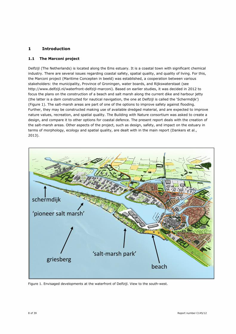
Delfzijl (The Netherlands) is located along the Ems estuary. It is a coastal town with significant chemical industry. There are several issues regarding coastal safety, spatial quality, and quality of living. For this, the Marconi project (Maritime Concepten in beeld) was established, a cooperation between various stakeholders: the municipality, Province of Groningen, water boards, and Rijkswaterstaat (see http://www.delfzijl.nl/waterfront-delfzijl-marconi). Based on earlier studies, it was decided in 2012 to focus the plans on the construction of a beach and salt marsh along the current dike and harbour jetty (the latter is a dam constructed for nautical navigation, the one at Delfzijl is called the ‘Schermdijk’) (Figure 1). The salt-marsh areas are part of one of the options to improve safety against flooding. Further, they may be constructed making use of available dredged material, and are expected to improve nature values, recreation, and spatial quality. The Building with Nature consortium was asked to create a design, and compare it to other options for coastal defence. The present report deals with the creation of the salt-marsh areas. Other aspects of the project, such as design, safety, and impact on the estuary in terms of morphology, ecology and spatial quality, are dealt with in the main report (Dankers et al., 2013).
Figure 1. Envisaged developments at the waterfront of Delfzijl. View to the south-west.
schermdijk
‘pioneer salt marsh’
‘salt-marsh park’
beachgriesberg
Report number C145/12 9 of 39
1.2 Aim
The present report is a literature survey on the best practices for creating the envisaged salt-marsh areas. As there are currently no salt marshes at Delfzijl, a salt marsh would have to be constructed. Such a salt marsh should be stable enough for coastal protection, and have as high as possible nature values and degree of naturalness, given the specific situation at Delfzijl. Underlying questions are: 1. Which factors are of importance when creating a salt marsh? 2. What are most suitable methods for creating a new salt marsh at this location? 3. What naturalness and nature values can be achieved, and how? An important starting point is that any salt-marsh development should follow the Building with Nature approach, i.e. “developing infrastructure while creating opportunities for nature”. In practice this means that the design makes use of the natural processes of the area, and that nature values are incorporated into it. Designs should fit within the natural system and/or enhance natural values in case of a degraded system.
1.3 Approach
In the Netherlands, no salt marshes have yet been created from dredged material. Consequently there is no design readily available. The above questions are therefore approached through a literature study, concerning salt-marsh processes in general and existing projects on salt-marsh (re)creation worldwide. The focus is on literature and projects relevant to the situation at Delfzijl, i.e. matching the requirements of the project, and matching the abiotic and biotic conditions as far as possible. Both scientific and grey literature are used, where the grey literature should be as much as possible freely available (e.g. through the internet), be written by scientists and from sources that standard apply an internal and/or external review procedure. This report does not present the design itself: for that, other aspects such as stakeholder consultations and large-scale modelling need to be carried out as well. Those aspects are dealt with in the main report (Dankers et al., 2013). The present report gives information on various aspects of salt marshes, that are needed for, and have been used in, the design process. This report has been developed as part of the design process and is therefore tailored to the situation at Delfzijl. However, the information can also be used for other locations. First, in Chapter 2 we will give some information on the specific situation at Delfzijl, as this gives the boundary conditions for the literature search. in Chapter 3 factors that are of importance in the construction of salt marshes are discussed. In Chapter 4 this is put into perspective for the situation at Delfzijl. The report is concluded with recommendations for creating a salt marsh at Delfzijl.
10 of 39 Report number C145/12
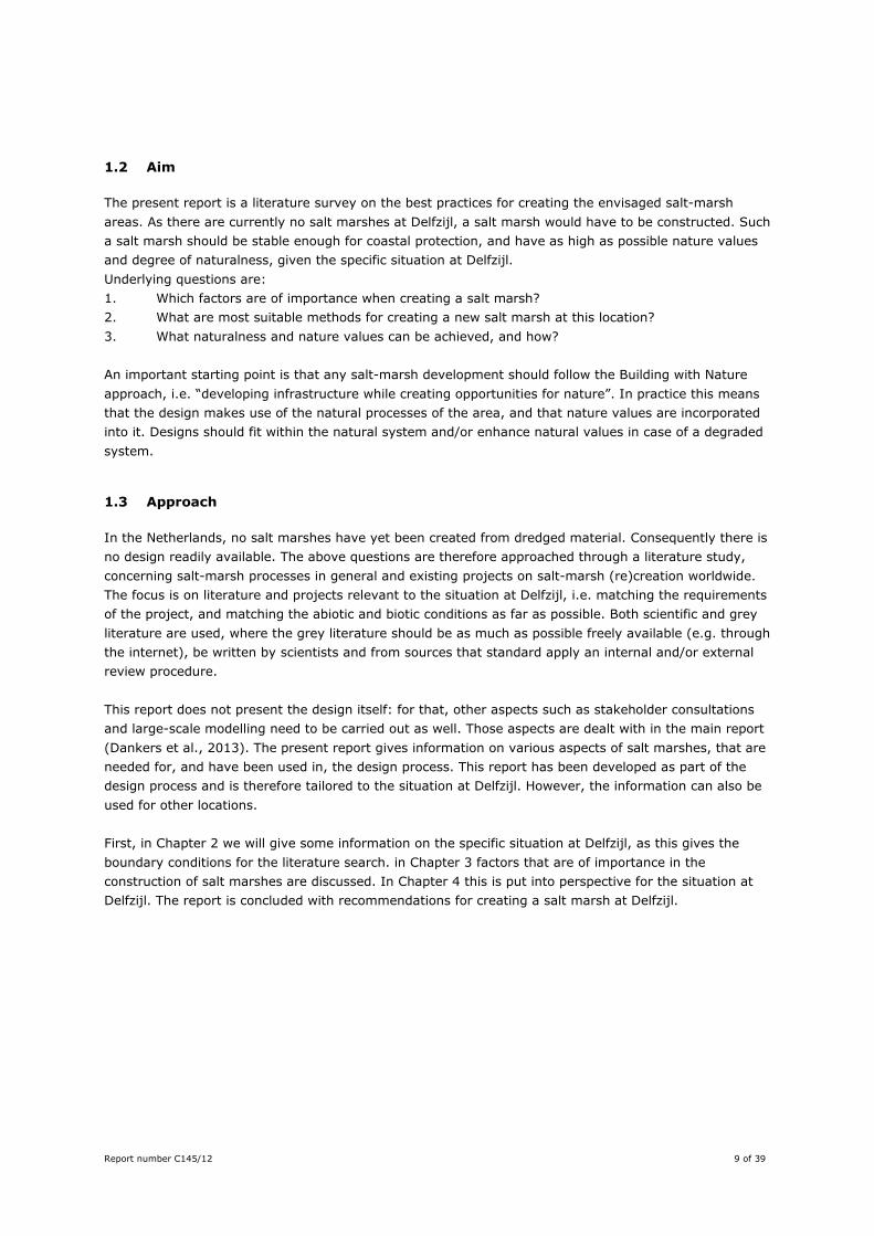
2 The situation at Delfzijl Delfzijl is located in the Ems estuary, and experiences an average tidal range of 3.0 m (Figure 2). Salinity is with an average values of 23 promille mostly saline, but varies with the tide and freshwater outflow from sluices and the river Ems (De Jonge, 1992). Suspended sediment concentrations are around 50 mg/l, which is outside the estuarine turbidity maximum which lies further upstream. The dikes are bordered by intertidal and subtidal areas that consist of sediment with mud contents (< 63 μm) ranging from 25 – 50% to 75 – 100% (Mulder, 1998). The area in front of the Schermdijk consists partly of intertidal flats, and partly of sand flats permanently under water (Figure 3).
Figure 2. Map of Delfzijl and its surroundings. The white box indicates the planning area, and the red circles current salt-marsh areas in the region.
Delfzijl
planning area Dollard
Ems
Groningen
Krummhörn
Report number C145/12 11 of 39
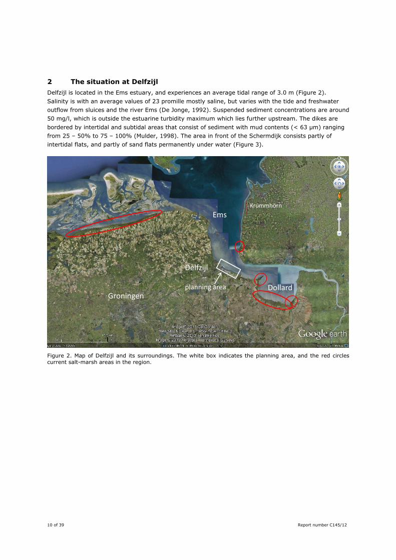
Figure 3. Bathymetry of the Ems around Delfzijl. All blue shades are below NAP; the darker the blue the deeper the water (Rijkswaterstaat data derived through Open Earth, no colorbar available). A detailed version of the area bordering the Schermdijk can be found in Supplement 1 in this report.
Historically (before 1600; Dijkema, 1987), the area around Delfzijl consisted of salt marshes and brackish marshes, that were successively embanked throughout the centuries. At the moment, there are no longer salt marshes at Delfzijl. The nearest (relatively small) marshes are at 7 km distance, whereas larger areas of salt marsh can be found in the Dollard (15 km) and the Groninger mainland (35 – 40 km) (Figure 2). These are all temperate salt marshes that mainly consist of inorganic mud, deposited by the flooding waters. A new salt marsh at Delfzijl would therefore fit into the estuarine system as compared to the historic reference. The fact that there is no salt marsh currently present, indicates that not all conditions are suitable for salt marsh development, and that measures are necessary if one would like to create one at this location. In the intertidal area, a waste dump of calcareous material from soda production is present, locally named ‘Griesberg’ (Figure 3). It has a high pH and different geotechnical properties than the natural sediment (see Appendix 1 of the main report Dankers et al., 2013). Initially, it was thought that the material could be used in creating a salt marsh, but a field visit showed that this is not feasible because of its geotechnical properties and very high pH. The general design of one of the possible future developments at Delfzijl is given in Figure 1. Between the estuary and the mainland lies a dam for aiding ships: the Schermdijk (Figure 3). Freshwater discharge from the hinterland takes also place in this harbour canal. The mixing between fresh and salt water leads to the sedimentation of (mainly) marine mud in the canal, and a need for (intensive) dredging. The plans consist of salt marshes and an artificial beach. The ‘salt-marsh park’ lies relatively high in the tidal frame and is accessible for recreation. It will be built with dredged material from the harbour. The base of the ‘pioneer salt marsh’ will also consist of dredged material, in the form of a slope with the highest part around Mean High Tide. Brushwood groynes take care of suitable hydrodynamics of
Griesberg
Schermdijk
12 of 39 Report number C145/12
salt-marsh development. The base will be enlarged laterally by yearly additions of dredged material, but the vertical growth of the salt marsh is expected to take place through natural sedimentation. The pioneer salt marsh should be as natural as possible and form a buffer for wave attack. A more detailed description of Delfzijl and its surroundings, and the Marconi project can be found in Appendix 2 of the main report (Dankers et al., 2013) and on http://www.delfzijl.nl/waterfront-delfzijl-marconi/. Based on the envisaged design above, this study will focus on how to develop a salt marsh that:
- will be developed in an intertidal and subtidal area, - is built partly from dredged material, where the dredged material will be added regularly to
enlarge the salt-marsh area, - consists largely of inorganic (mineral) sediment, - is as natural as possible, with nature values are as high as possible, - is developed using Building with Nature principles.
Report number C145/12 13 of 39
3 Processes and factors
3.1 Natural salt-marsh functioning
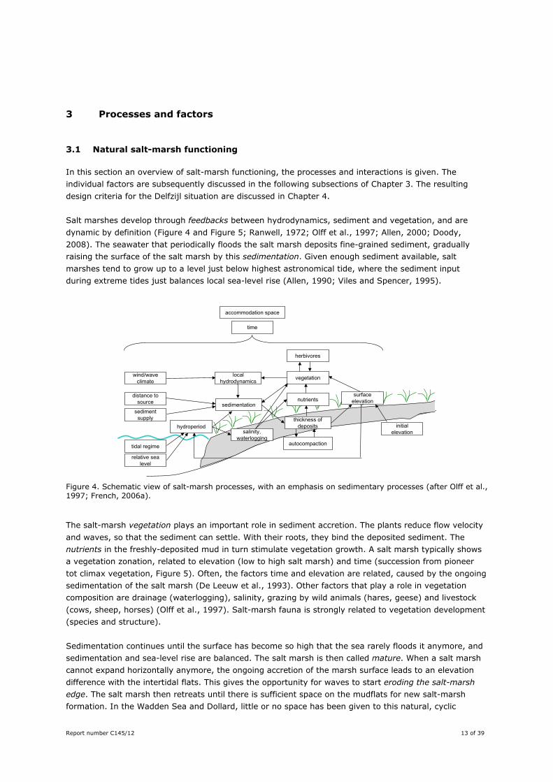
In this section an overview of salt-marsh functioning, the processes and interactions is given. The individual factors are subsequently discussed in the following subsections of Chapter 3. The resulting design criteria for the Delfzijl situation are discussed in Chapter 4. Salt marshes develop through feedbacks between hydrodynamics, sediment and vegetation, and are dynamic by definition (Figure 4 and Figure 5; Ranwell, 1972; Olff et al., 1997; Allen, 2000; Doody, 2008). The seawater that periodically floods the salt marsh deposits fine-grained sediment, gradually raising the surface of the salt marsh by this sedimentation. Given enough sediment available, salt marshes tend to grow up to a level just below highest astronomical tide, where the sediment input during extreme tides just balances local sea-level rise (Allen, 1990; Viles and Spencer, 1995).
Figure 4. Schematic view of salt-marsh processes, with an emphasis on sedimentary processes (after Olff et al., 1997; French, 2006a).
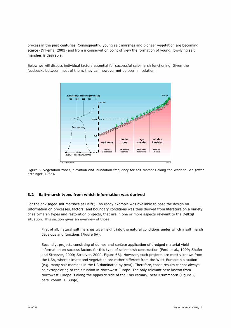
The salt-marsh vegetation plays an important role in sediment accretion. The plants reduce flow velocity and waves, so that the sediment can settle. With their roots, they bind the deposited sediment. The nutrients in the freshly-deposited mud in turn stimulate vegetation growth. A salt marsh typically shows a vegetation zonation, related to elevation (low to high salt marsh) and time (succession from pioneer tot climax vegetation, Figure 5). Often, the factors time and elevation are related, caused by the ongoing sedimentation of the salt marsh (De Leeuw et al., 1993). Other factors that play a role in vegetation composition are drainage (waterlogging), salinity, grazing by wild animals (hares, geese) and livestock (cows, sheep, horses) (Olff et al., 1997). Salt-marsh fauna is strongly related to vegetation development (species and structure). Sedimentation continues until the surface has become so high that the sea rarely floods it anymore, and sedimentation and sea-level rise are balanced. The salt marsh is then called mature. When a salt marsh cannot expand horizontally anymore, the ongoing accretion of the marsh surface leads to an elevation difference with the intertidal flats. This gives the opportunity for waves to start eroding the salt-marsh edge. The salt marsh then retreats until there is sufficient space on the mudflats for new salt-marsh formation. In the Wadden Sea and Dollard, little or no space has been given to this natural, cyclic
sediment supply
tidal regime
wind/wave climate
relative sea level
local hydrodynamics vegetation
surface elevation
hydroperiodthickness of
deposits initial elevation
autocompaction
sedimentationnutrients
distance to source
time
accommodation space
salinity,waterlogging
herbivores
14 of 39 Report number C145/12
process in the past centuries. Consequently, young salt marshes and pioneer vegetation are becoming scarce (Dijkema, 2005) and from a conservation point of view the formation of young, low-lying salt marshes is desirable. Below we will discuss individual factors essential for successful salt-marsh functioning. Given the feedbacks between most of them, they can however not be seen in isolation.
Figure 5. Vegetation zones, elevation and inundation frequency for salt marshes along the Wadden Sea (after Erchinger, 1985).
3.2 Salt-marsh types from which information was derived
For the envisaged salt marshes at Delfzijl, no ready example was available to base the design on. Information on processes, factors, and boundary conditions was thus derived from literature on a variety of salt-marsh types and restoration projects, that are in one or more aspects relevant to the Delfzijl situation. This section gives an overview of those:
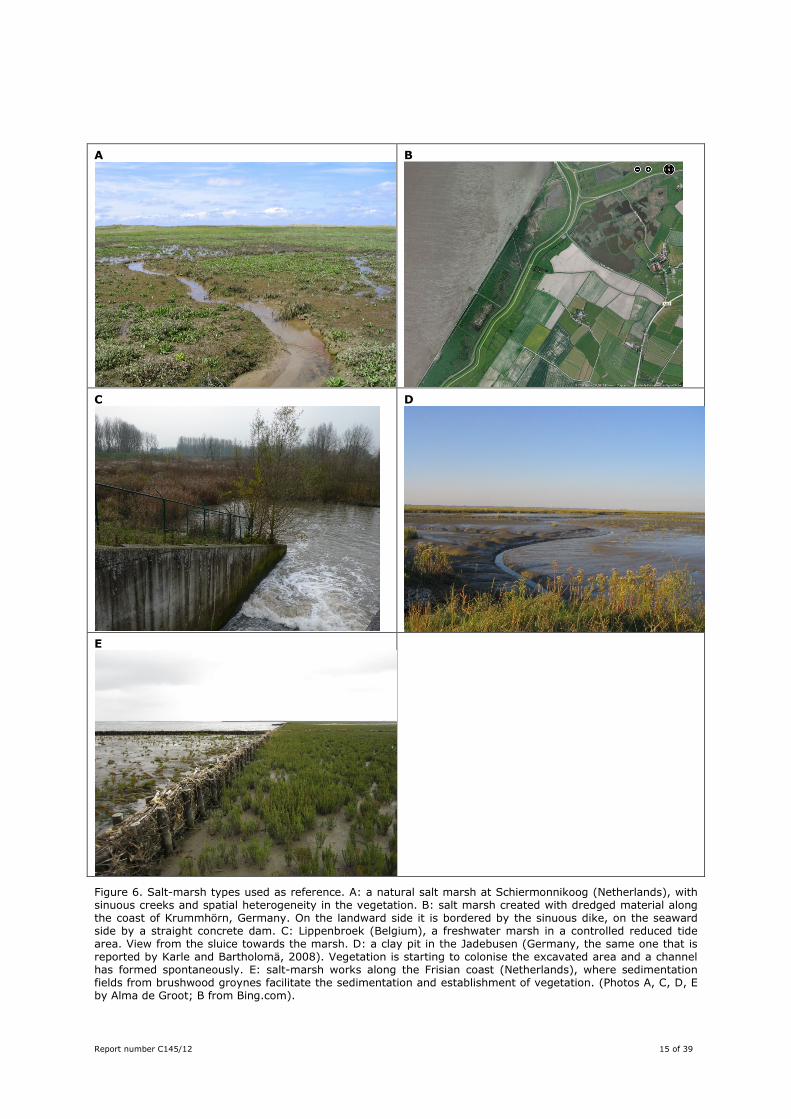
First of all, natural salt marshes give insight into the natural conditions under which a salt marsh develops and functions (Figure 6A). Secondly, projects consisting of dumps and surface application of dredged material yield information on success factors for this type of salt-marsh construction (Ford et al., 1999; Shafer and Streever, 2000; Streever, 2000, Figure 6B). However, such projects are mostly known from the USA, where climate and vegetation are rather different from the West-European situation (e.g. many salt marshes in the US dominated by peat). Therefore, those results cannot always be extrapolating to the situation in Northwest Europe. The only relevant case known from Northwest Europe is along the opposite side of the Ems estuary, near Krummhörn (Figure 2, pers. comm. J. Bunje).
Report number C145/12 15 of 39
A
B
C
D
E
Figure 6. Salt-marsh types used as reference. A: a natural salt marsh at Schiermonnikoog (Netherlands), with sinuous creeks and spatial heterogeneity in the vegetation. B: salt marsh created with dredged material along the coast of Krummhörn, Germany. On the landward side it is bordered by the sinuous dike, on the seaward side by a straight concrete dam. C: Lippenbroek (Belgium), a freshwater marsh in a controlled reduced tide area. View from the sluice towards the marsh. D: a clay pit in the Jadebusen (Germany, the same one that is reported by Karle and Bartholomä, 2008). Vegetation is starting to colonise the excavated area and a channel has formed spontaneously. E: salt-marsh works along the Frisian coast (Netherlands), where sedimentation fields from brushwood groynes facilitate the sedimentation and establishment of vegetation. (Photos A, C, D, E by Alma de Groot; B from Bing.com).
16 of 39 Report number C145/12
Most experience with newly-created salt marshes comes from a third type of salt marshes, created through breaches or sluices in the sea wall (Figure 6C). These are called managed realignment (MR), regulated tidal exchange (RTE), or controlled reduced tide, CRT). Some of these areas were also created through accidental breaches during storms. They consist of letting salt water re-enter formally embanked areas, turning those lands into salt marsh and intertidal flats. Most projects have been carried out in the past decade. By now various management-oriented and scientific texts can be found online, especially from the UK where managed realignment has been carried out at a large number of places (French et al., 2000; Van Oevelen et al., 2000; French, 2001; Crooks et al., 2002; Wolters et al., 2005; French, 2006b; Friess et al., 2012b; Mossman et al., 2012; Spencer and Harvey, 2012; Vijverberg et al., 2012). Such projects are not fully comparable to the case at Delfzijl, but do yield important information on the dispersal and establishment of vegetation, the role of elevation, sedimentation processes and general drainage requirements.
As a fourth example, clay pits yield relevant information on vegetation establishment and creek formation. In clay pits, an original salt marsh is excavated and then abandoned to fill in with sediment and vegetation again (Karle and Bartholomä, 2008, Figure 6D).
A final example is that of the salt-marsh works along the coasts of the Wadden Sea (Scarton et al., 2000; Dijkema et al., 2001; Hofstede, 2003; Dijkema et al., 2008, Figure 6E). The salt marshes in the larger region around Delfzijl belong to this type. Brushwood groins and ditches were constructed to facilitate the establishment of salt marshes. This has led to extensive areas of semi-natural salt marshes. Due to the drainage, salt-marsh formation commences lower on the intertidal flats than in a natural salt marsh (Dijkema et al., 1990). The ditches have led to a rectangular, oversized drainage pattern, in contrast to creeks in natural salt marshes that are sinuous. The brushwood dams need to be maintained to conserve salt-marsh area, but the maintenance is now minimized based on experience and monitoring (Dijkema et al., 2008). Management and monitoring of these areas have led to experience in how to create a salt marsh from an intertidal area.
3.3 Elevation and tidal range
Surface elevation is a key factor for salt-marsh development and restoration (e.g. Allen, 2000; Crooks et al., 2002; French, 2006b; Friess et al., 2012a). Together with tidal range, it determines hydroperiod and flooding frequency. In turn and together with sediment properties, these determine salinity, aeration and stability of the soil, which are the drivers for the establishment and survival of salt-marsh vegetation. Salt marshes develop between mean high tide (MHT) and the height at which the inundation frequency is five times per year (De Jong et al., 1998). As the tidal range varies from place to place, these boundaries are location-dependent. Salt marshes that are developed using brushwood groynes and ditching may start some tens of centimetres lower on the intertidal flats (Dijkema et al., 1990). If surface elevation is below MHT, the area will be a tidal flat. On the other hand, surface elevation should not be so high that the inundation frequency is less than a few times per year. Then soil salinity will be too low, so that salt-marsh plants will be outcompeted by glycophytes (Wolters et al., 2005, Figure 7). Relatively high initial elevation in the tidal frame will facilitate vegetation colonisation (Friess et al., 2012b), but the salt marsh may rapidly become a high salt marsh which is often not desirable from a nature-conservation point of view.
Report number C145/12 17 of 39
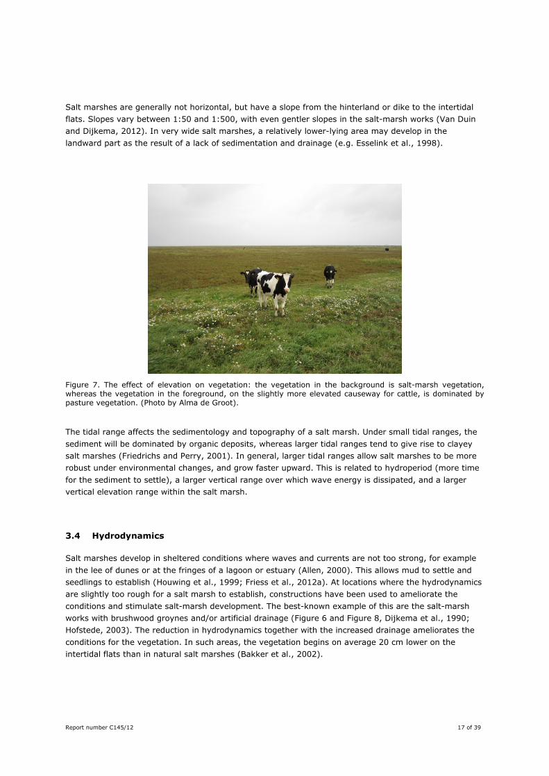
Salt marshes are generally not horizontal, but have a slope from the hinterland or dike to the intertidal flats. Slopes vary between 1:50 and 1:500, with even gentler slopes in the salt-marsh works (Van Duin and Dijkema, 2012). In very wide salt marshes, a relatively lower-lying area may develop in the landward part as the result of a lack of sedimentation and drainage (e.g. Esselink et al., 1998).
Figure 7. The effect of elevation on vegetation: the vegetation in the background is salt-marsh vegetation, whereas the vegetation in the foreground, on the slightly more elevated causeway for cattle, is dominated by pasture vegetation. (Photo by Alma de Groot).
The tidal range affects the sedimentology and topography of a salt marsh. Under small tidal ranges, the sediment will be dominated by organic deposits, whereas larger tidal ranges tend to give rise to clayey salt marshes (Friedrichs and Perry, 2001). In general, larger tidal ranges allow salt marshes to be more robust under environmental changes, and grow faster upward. This is related to hydroperiod (more time for the sediment to settle), a larger vertical range over which wave energy is dissipated, and a larger vertical elevation range within the salt marsh.
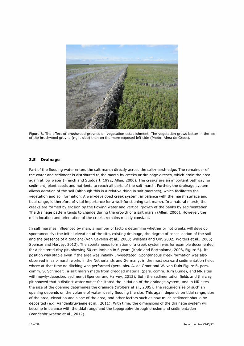
3.4 Hydrodynamics
Salt marshes develop in sheltered conditions where waves and currents are not too strong, for example in the lee of dunes or at the fringes of a lagoon or estuary (Allen, 2000). This allows mud to settle and seedlings to establish (Houwing et al., 1999; Friess et al., 2012a). At locations where the hydrodynamics are slightly too rough for a salt marsh to establish, constructions have been used to ameliorate the conditions and stimulate salt-marsh development. The best-known example of this are the salt-marsh works with brushwood groynes and/or artificial drainage (Figure 6 and Figure 8, Dijkema et al., 1990; Hofstede, 2003). The reduction in hydrodynamics together with the increased drainage ameliorates the conditions for the vegetation. In such areas, the vegetation begins on average 20 cm lower on the intertidal flats than in natural salt marshes (Bakker et al., 2002).
18 of 39 Report number C145/12
Figure 8. The effect of brushwood groynes on vegetation establishment. The vegetation grows better in the lee of the brushwood groyne (right side) than on the more exposed left side (Photo: Alma de Groot).
3.5 Drainage
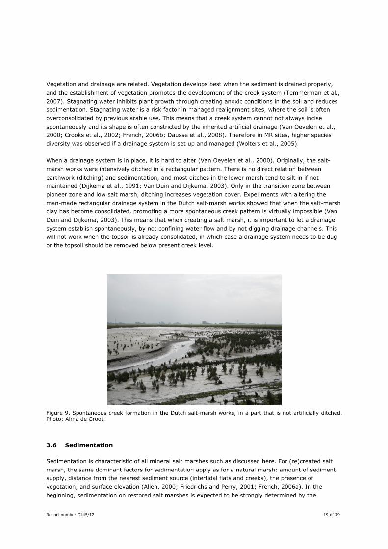
Part of the flooding water enters the salt marsh directly across the salt-marsh edge. The remainder of the water and sediment is distributed to the marsh by creeks or drainage ditches, which drain the area again at low water (French and Stoddart, 1992; Allen, 2000). The creeks are an important pathway for sediment, plant seeds and nutrients to reach all parts of the salt marsh. Further, the drainage system allows aeration of the soil (although this is a relative thing in salt marshes), which facilitates the vegetation and soil formation. A well-developed creek system, in balance with the marsh surface and tidal range, is therefore of vital importance for a well-functioning salt marsh. In a natural marsh, the creeks are formed by erosion by the flowing water and vertical growth of the banks by sedimentation. The drainage pattern tends to change during the growth of a salt marsh (Allen, 2000). However, the main location and orientation of the creeks remains mostly constant. In salt marshes influenced by man, a number of factors determine whether or not creeks will develop spontaneously: the initial elevation of the site, existing drainage, the degree of consolidation of the soil and the presence of a gradient (Van Oevelen et al., 2000; Williams and Orr, 2002; Wolters et al., 2005; Spencer and Harvey, 2012). The spontaneous formation of a creek system was for example documented for a sheltered clay pit, showing 50 cm incision in 6 years (Karle and Bartholomä, 2008, Figure 6). Its position was stable even if the area was initially unvegetated. Spontaneous creek formation was also observed in salt-marsh works in the Netherlands and Germany, in the most seaward sedimentation fields where at that time no ditching was performed (pers. obs. A. de Groot and W. van Duin Figure 6, pers. comm. S. Schrader), a salt marsh made from dredged material (pers. comm. Jürn Bunje), and MR sites with newly-deposited sediment (Spencer and Harvey, 2012). Both the sedimentation fields and the clay pit showed that a distinct water outlet facilitated the initiation of the drainage system, and in MR sites the size of the opening determines the drainage (Wolters et al., 2005). The required size of such an opening depends on the volume of water ideally flooding the site. This again depends on tidal range, size of the area, elevation and slope of the area, and other factors such as how much sediment should be deposited (e.g. Vandenbruwaene et al., 2011). With time, the dimensions of the drainage system will become in balance with the tidal range and the topography through erosion and sedimentation (Vandenbruwaene et al., 2012).
Report number C145/12 19 of 39
Vegetation and drainage are related. Vegetation develops best when the sediment is drained properly, and the establishment of vegetation promotes the development of the creek system (Temmerman et al., 2007). Stagnating water inhibits plant growth through creating anoxic conditions in the soil and reduces sedimentation. Stagnating water is a risk factor in managed realignment sites, where the soil is often overconsolidated by previous arable use. This means that a creek system cannot not always incise spontaneously and its shape is often constricted by the inherited artificial drainage (Van Oevelen et al., 2000; Crooks et al., 2002; French, 2006b; Dausse et al., 2008). Therefore in MR sites, higher species diversity was observed if a drainage system is set up and managed (Wolters et al., 2005). When a drainage system is in place, it is hard to alter (Van Oevelen et al., 2000). Originally, the salt-marsh works were intensively ditched in a rectangular pattern. There is no direct relation between earthwork (ditching) and sedimentation, and most ditches in the lower marsh tend to silt in if not maintained (Dijkema et al., 1991; Van Duin and Dijkema, 2003). Only in the transition zone between pioneer zone and low salt marsh, ditching increases vegetation cover. Experiments with altering the man-made rectangular drainage system in the Dutch salt-marsh works showed that when the salt-marsh clay has become consolidated, promoting a more spontaneous creek pattern is virtually impossible (Van Duin and Dijkema, 2003). This means that when creating a salt marsh, it is important to let a drainage system establish spontaneously, by not confining water flow and by not digging drainage channels. This will not work when the topsoil is already consolidated, in which case a drainage system needs to be dug or the topsoil should be removed below present creek level.
Figure 9. Spontaneous creek formation in the Dutch salt-marsh works, in a part that is not artificially ditched. Photo: Alma de Groot.
3.6 Sedimentation
Sedimentation is characteristic of all mineral salt marshes such as discussed here. For (re)created salt marsh, the same dominant factors for sedimentation apply as for a natural marsh: amount of sediment supply, distance from the nearest sediment source (intertidal flats and creeks), the presence of vegetation, and surface elevation (Allen, 2000; Friedrichs and Perry, 2001; French, 2006a). In the beginning, sedimentation on restored salt marshes is expected to be strongly determined by the
20 of 39 Report number C145/12
antecedent conditions, until sufficient sediment has been deposited to create a balance between geomorphology and hydrodynamics (De Groot et al., 2011; Spencer and Harvey, 2012). Firstly, sediment supply consists of the fine-grained sediment suspended in the flooding water. In estuaries this concentration is generally larger than in coastal seas. Although this gives the potential for salt-marsh sedimentation rate, local factors have an influence, too. For example, the average sedimentation rate on the salt marshes in the Dollard (with high suspended sediment concentrations, SSC) is 0.8 cm y-1, whereas that on the salt marshes along the Groningen north coast (with lower SSC) is 0.7 to 1.3 cm y-1 (Dijkema et al., 2008; Esselink et al., 2011). Secondly, pioneer vegetation consisting of annual species binds the sediment with its roots, but may dislodge the deposited sediment through scouring the sediment while moving in the water (Friess et al., 2012a). Sedimentation rates only markedly increase when perennial grasses (such as Puccinellia maritima and Spartina spp.) establish (Langlois et al., 2003). These species are also able to grow through a layer of deposited sediment, and by doing so binding the sediment with their roots. Thirdly, sedimentation rates tend to decrease with distance from the salt-marsh edge and creeks. Areas that are very elongated may therefore lack sedimentation in the inner parts, especially in case the flooding water cannot reach the interior well (Esselink et al., 1998; Kornman, 2000). In MR sites, the size of the opening may restrict the delivery of water and thus sediment to the salt marsh. For survival of a salt marsh, sedimentation rate (or more correctly: surface elevation change, Cahoon et al., 1999) has to be larger than relative sea-level rise. A new salt marsh should thus be constructed such that sedimentation is possible, i.e. there should be sufficient exchange of sediment-laden water with the estuary or sea.
3.7 Salt-marsh sediment
The sediment of natural salt marshes is fine-grained and/or organic. Because of the frequent flooding by sea water, the soil is typically waterlogged to some degree. In general the soil is saline (sometimes hypersaline), and has consequently very specific redox potential and pH. These soil conditions support the typical salt-marsh vegetation that is adapted to these generally harsh conditions. Waterlogging should not be too severe however, because this may kill the vegetation. Such conditions occur when drainage is not sufficient When sediment is used to build or nourish a salt-marsh, sediment properties and soil formation thus play a large role. The sediment should contain at least some mud for the salt-marsh plants to establish (Houwing et al., 1999), and preferably some organic material too (Van Oevelen et al., 2000). The insufficient build-up of organic material in the soil is often a bottleneck for the functioning of recreated salt marshes (Van Oevelen et al., 2000). The sediment should also be free of contaminants that might affect the flora and fauna. With time, the sediment undergoes autocompaction, where sediment density increases and resilience against edge erosion is increased. Therefore young, recreated salt marshes may be more prone to erosion than older salt marshes (Van Duin et al., 2007). Artificially deposited sediment will generally exhibit subsidence (compaction), the amount depending on sediment grain size, initial bulk density and water content. As subsidence values of 1 m have been reported (Nakamura, 2006), compaction needs to be taken into account in the design. Also livestock grazing increases this compaction, leading to a lowering of the surface of up to 10 cm (Bakker et al., 2002, De Groot, unpublished data).
Report number C145/12 21 of 39
On a coast where salt marshes grow seawards (as is mimicked here), the sediment grain size tends to exhibit ‘fining upward’, i.e. the sediment grades from coarse (sand) to fine (mud) from bottom to top. When dredge spoil is used to build (the base of) a salt marsh, the stability and functioning of the area can be optimized by using sandy material until just under MHT and muddier material for the higher parts. In the USA, experiments have been carried out with dispersing dredged material from a directly adjacent channel over de marsh surface (Ford et al., 1999). The Spartina plants survived the 23 mm deposition well, but it is uncertain if this method works for a salt marsh at Delfzijl, mostly because the vegetation type will be very different. The European Puccinellia maritima is known to tolerate between 8 mm and several cm’s of burial (Langlois et al., 2001).
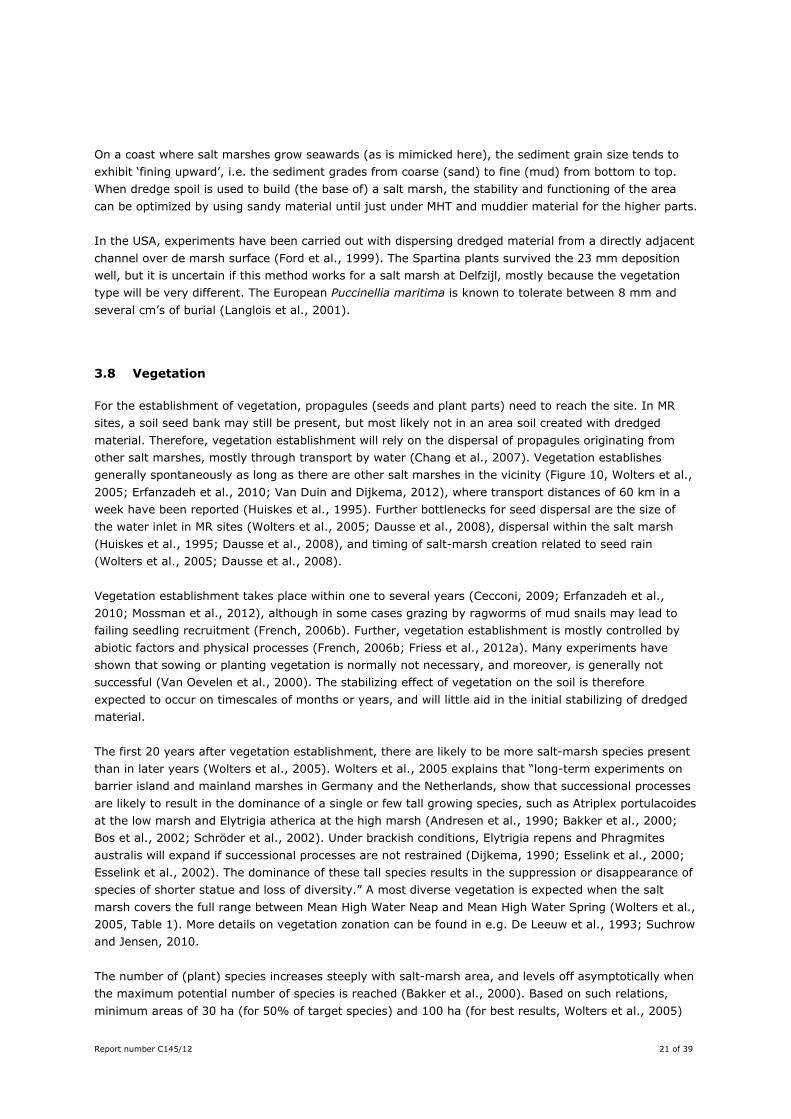
3.8 Vegetation
For the establishment of vegetation, propagules (seeds and plant parts) need to reach the site. In MR sites, a soil seed bank may still be present, but most likely not in an area soil created with dredged material. Therefore, vegetation establishment will rely on the dispersal of propagules originating from other salt marshes, mostly through transport by water (Chang et al., 2007). Vegetation establishes generally spontaneously as long as there are other salt marshes in the vicinity (Figure 10, Wolters et al., 2005; Erfanzadeh et al., 2010; Van Duin and Dijkema, 2012), where transport distances of 60 km in a week have been reported (Huiskes et al., 1995). Further bottlenecks for seed dispersal are the size of the water inlet in MR sites (Wolters et al., 2005; Dausse et al., 2008), dispersal within the salt marsh (Huiskes et al., 1995; Dausse et al., 2008), and timing of salt-marsh creation related to seed rain (Wolters et al., 2005; Dausse et al., 2008). Vegetation establishment takes place within one to several years (Cecconi, 2009; Erfanzadeh et al., 2010; Mossman et al., 2012), although in some cases grazing by ragworms of mud snails may lead to failing seedling recruitment (French, 2006b). Further, vegetation establishment is mostly controlled by abiotic factors and physical processes (French, 2006b; Friess et al., 2012a). Many experiments have shown that sowing or planting vegetation is normally not necessary, and moreover, is generally not successful (Van Oevelen et al., 2000). The stabilizing effect of vegetation on the soil is therefore expected to occur on timescales of months or years, and will little aid in the initial stabilizing of dredged material. The first 20 years after vegetation establishment, there are likely to be more salt-marsh species present than in later years (Wolters et al., 2005). Wolters et al., 2005 explains that “long-term experiments on barrier island and mainland marshes in Germany and the Netherlands, show that successional processes are likely to result in the dominance of a single or few tall growing species, such as Atriplex portulacoides at the low marsh and Elytrigia atherica at the high marsh (Andresen et al., 1990; Bakker et al., 2000; Bos et al., 2002; Schröder et al., 2002). Under brackish conditions, Elytrigia repens and Phragmites australis will expand if successional processes are not restrained (Dijkema, 1990; Esselink et al., 2000; Esselink et al., 2002). The dominance of these tall species results in the suppression or disappearance of species of shorter statue and loss of diversity.” A most diverse vegetation is expected when the salt marsh covers the full range between Mean High Water Neap and Mean High Water Spring (Wolters et al., 2005, Table 1). More details on vegetation zonation can be found in e.g. De Leeuw et al., 1993; Suchrow and Jensen, 2010. The number of (plant) species increases steeply with salt-marsh area, and levels off asymptotically when the maximum potential number of species is reached (Bakker et al., 2000). Based on such relations, minimum areas of 30 ha (for 50% of target species) and 100 ha (for best results, Wolters et al., 2005)
22 of 39 Report number C145/12
are given. For optimal salt-marsh functioning, where the natural processes and dynamics are also present, 500 ha is a minimum (Van Duin and Dijkema, 2012, based on Bakker et al., 2000). Not only the total area is of importance, also the width perpendicular to the shoreline, as this gives the accommodation space for vegetation zones (Wolters et al., 2005). Small salt marshes will only support part of the vegetation zones, be less resilient against environmental change, such as yearly fluctuations of MHW (Dijkema et al., 2001), and not be able to exhibit natural dynamics in area. Highest plant species diversity was found in MR areas that were livestock-grazed and/or mown (Wolters et al., 2005). This is in line with earlier work in The Netherlands (Figure 10, Bakker et al., 2000), but is not always supported by observations elsewhere (pers. comm. K. Kiehl, A. Wanner, K. Jensen). Livestock grazing not only removes tall vegetation so that smaller plants get more room, but the trampling of the animals compact the wet soil so that redox conditions change, favouring earlier-successional species (Schrama, 2012). Moderate grazing regimes generally favour most plant and animal species, but the exact number of animals should be based on local drainage, clay content, weather conditions and surface elevation (Esselink et al., 2009; Van Duin and Dijkema, 2012). Too many animals in a wet part of the MR site of Noord-Friesland Buitendijks (NL) has given rise to a trampled secondary pioneer zone, that is not suitable for typical salt-marsh birds that are one of the targets for this area (pers. comm. P. Esselink).
Figure 10. Examples of salt-marsh vegetation and the effects of vegetation management. Upper left: establishment of pioneer vegetation (Salicornia europaea); Upper right: salt-marsh vegetation rich in Sea aster (Aster tripolium), a situation often desired by managers; Lower left: monoculture of Elytrigia atherica in an ungrazed salt marsh; Lower right: a so-called summer polder, that experiences hardly any inundation from the sea, turns into a pasture with e.g. Elymus repens and Agrostis stolonifera. Photos: Alma de Groot.
Report number C145/12 23 of 39
3.9 Fauna
The colonisation of (re)created salt marshes by fauna ranges from good to poor (Van Oevelen et al., 2000; Pétillon and Garbutt, 2008). This strongly depends on species group, on the targets set beforehand, and on vegetation management. Because of the strong site-dependence, we will not go into detail here. More information can be found in the main report and appendices (Dankers et al., 2013), indicating that a key factor for a successful habitat for birds is minimalizing disturbance by predators, humans (recreation) and windmills.
24 of 39 Report number C145/12
4 Techniques and management for creating salt marshes
4.1 Techniques for creating salt marshes
There are several established and new management methods for (re)creating or steering salt-marsh development. An overview and details can be found in De Groot et al., 2013. In the Dutch coastal zone policy as well as in the Building with Nature philosophy, ‘soft’ measures are favoured over ‘hard’ ones, and the methods listed below are roughly ordered from soft to hard. Soft engineering approaches use material akin to the natural environment, work with the natural processes if possible, and typically need to be repeated often, making it a no-regret method. Hard structures have a much longer life-time, and are typically static and non-flexible. Of course there is a large grey area in between. For the situation at Delfzijl, several of techniques are of interest, given in order from soft to hard:
1. Reduction of hydrodynamics: brushwood groynes, either in rectangular sedimentation fields or as breakwaters (either parallel or perpendicular to the shore). By reducing the hydrodynamics, they facilitate sedimentation and vegetation establishment (Scarton et al., 2000; Dijkema et al., 2001; Hofstede, 2003; Dijkema et al., 2008; Esselink et al., 2011).
2. Increasing elevation: application of dredged material to raise the surface of the tidal area so that
it becomes suitable for salt-marsh development (Nakamura, 2006; D'Alpaos et al., 2007; Stagg and Mendelssohn, 2010; Stagg and Mendelssohn, 2011).
3. Reduction of hydrodynamics: geotubes as breakwater to reduce hydrodynamics, or creating a
basin for dredged material. This method is still experimental (Cecconi, 2009).
4. Reduction of hydrodynamics: oyster or mussel reefs as breakwater. This method is still experimental in The Netherlands (Beck et al., 2011; Gedan et al., 2011; Scyphers et al., 2011).
5. Increase drainage: digging drainage channels to facilitate sediment aeration and vegetation
establishment, see previous section ‘Drainage’ (Esselink et al., 1998; Van Duin & Dijkema, 2003; Van Duin et al., 2007b).
6. Reduction of hydrodynamics: Stone or concrete dams as breakwaters and/or to create a basin
for dredged material (Pilkey and Wright, 1988; U.S.A.C.E., 2008; Esselink et al., 2011).
7. Reduction of hydrodynamics: Stone revetment to protect salt-marsh edge against erosion. This method should only be used as last resort (Doody, 2008; Esselink et al., 2011; Van Loon-Steensma and Slim, accepted).

Report number C145/12 25 of 39
4.2 Monitoring
To be able to evaluate the success of a project, adequate monitoring is essential. Based on the comparison between monitoring results and pre-defined targets, management can be adapted if needed. For that, quality or success criteria can be set up, that lead to a number of indicators to be monitored (Short et al., 2000). Also the monitoring itself can be made adaptive, where the monitoring program is regularly tuned to reflect the up to date monitoring needs (see e.g. http://www.ecoshape.nl/en_GB/wiki-guideline.html/guideline/83-EDD+-+Introduction+-+BwN+philosophy) Monitoring should be done before, during, and after implementation (e.g. Friess et al., 2008). The monitoring period should be long enough to monitor the actual development, where for salt marshes the usual 5 or 10 years is generally not enough (Williams and Faber, 2001). Parameters that are typically monitored in salt marshes include:
1. Vegetation composition and cover, 2. Soil: sediment composition (grain size, bulk density) and soil chemical state (salinity,
redox, pH, contaminants), 3. Surface elevation and sedimentation rate, 4. Drainage pattern and volumes 5. Species composition of birds and invertebrates, use of the area by birds (breeding,
resting, feeding). An example of a possible measure for success is the saturation index of vegetation. It gives the number of target species in the area compared to the total regional target species pool (Wolters et al., 2005).
4.3 Success of (re)created salt marshes
The success of created or restored salt marshes varies, i.e. only few (re)created salt marsh become a fully functional salt marsh, and many state that it is almost impossible at all to create a salt-marsh equal to a natural one (Streever, 2000; Van Oevelen et al., 2000; Crooks et al., 2002; Wolters et al., 2005; Elliott et al., 2007; Doody, 2008; Garbutt and Wolters, 2008; Cecconi, 2009; Mossman et al., 2012; Spencer and Harvey, 2012). In the UK, a large number of investigated “marshes created by managed realignment do not satisfy the requirements of the EU Habitats Directive”, also not on the long term (Mossman et al., 2012). A first reason for the sometimes disappointing MR results is that it takes time before the sedimentary processes, soil formation, vegetation, and fauna become established and the interactions between these system components are in balance (Van Oevelen et al., 2000). Secondly, not all boundary conditions are always optimal in restored or created salt marshes, so that the area cannot develop the same as a natural salt marsh would. In case areas are not considered successful, this is often related to a lack of salt-marsh functioning, whereas the structure may be meeting the target (Wolters et al., 2005). Further, species abundance and drainage pattern remained different from natural marshes (Crooks et al., 2002; Mossman et al., 2012), organic matter contents of the soil were lower (Van Oevelen et al., 2000), and redox conditions often deviated (Dausse et al., 2008; Mossman et al., 2012) Whether or not a recreated salt marsh is characterised as successful, depends further on the set goals, time, and what parameters are considered (Streever, 2000). An important first step is therefore to determine clear targets for the salt-marsh (re)creation (Wolters et al., 2005): what size, species, cover, habitat types etc. are the desired outcome of the project? With these targets, it should be realised that a salt marsh naturally undergoes succession, and that also interim habitats are valuable. This means that
26 of 39 Report number C145/12
management should not always aim at creating only the final habitats as quickly as possible (Williams and Faber, 2001). Sometimes an area can be considered relatively successful, where parts of the targets have been met but others not. For example, at the managed realignment site Noord-Friesland Buitendijks (NL), vegetation targets were met after 10 years, but the vegetation type was yet not suitable for the targets for birds (pers. comm. P. Esselink). For (re)created salt marshes, it is further important to have a good reference site to which the development can be compared (Wolters et al., 2005). This can either be a local reference site or a historical reference, depending on which is available. Methods to create salt marshes are preferably Building with Nature techniques, that aim at steering the natural processes rather than constructing the ‘final’ landscape at once. Such techniques are particularly suited for adaptive management, having therefore potentially larger success rates.
Report number C145/12 27 of 39
5 Application at Delfzijl
5.1 Conditions for salt marshes at Delfzijl
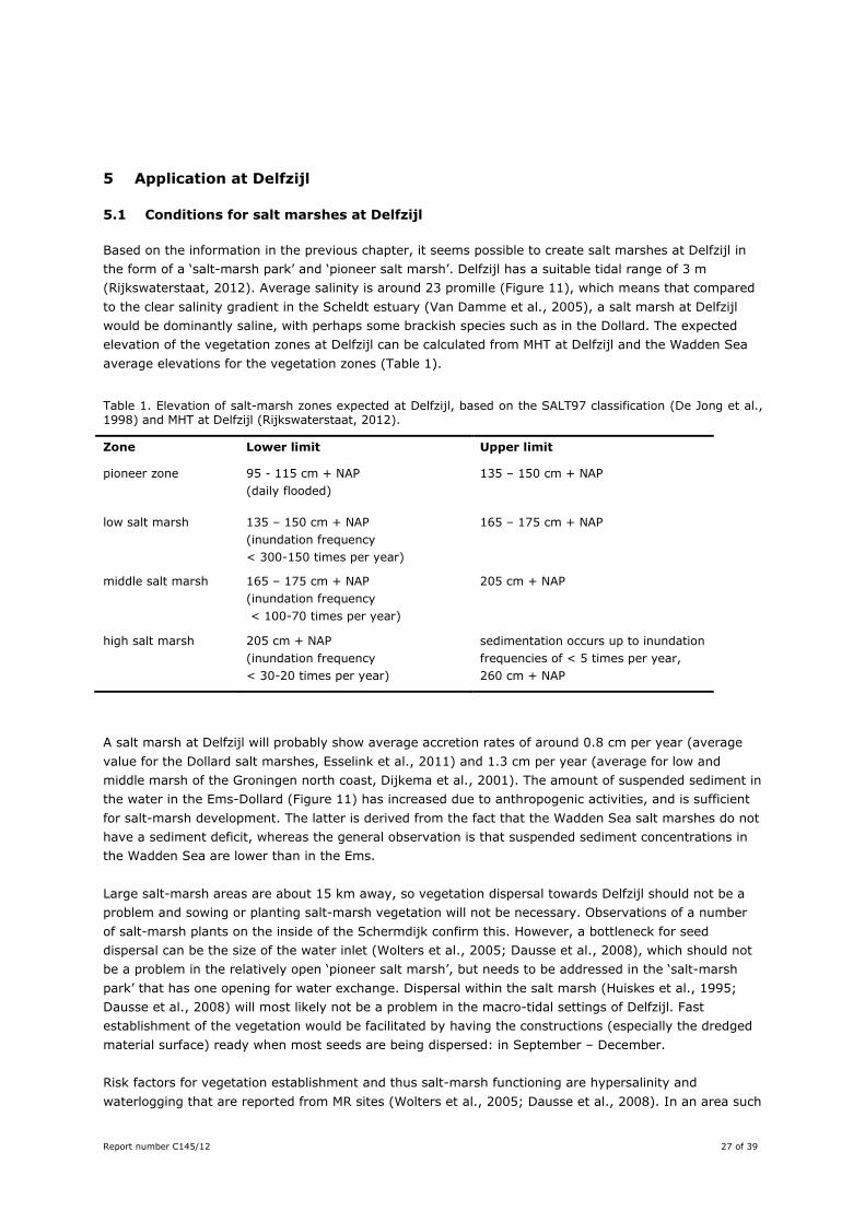
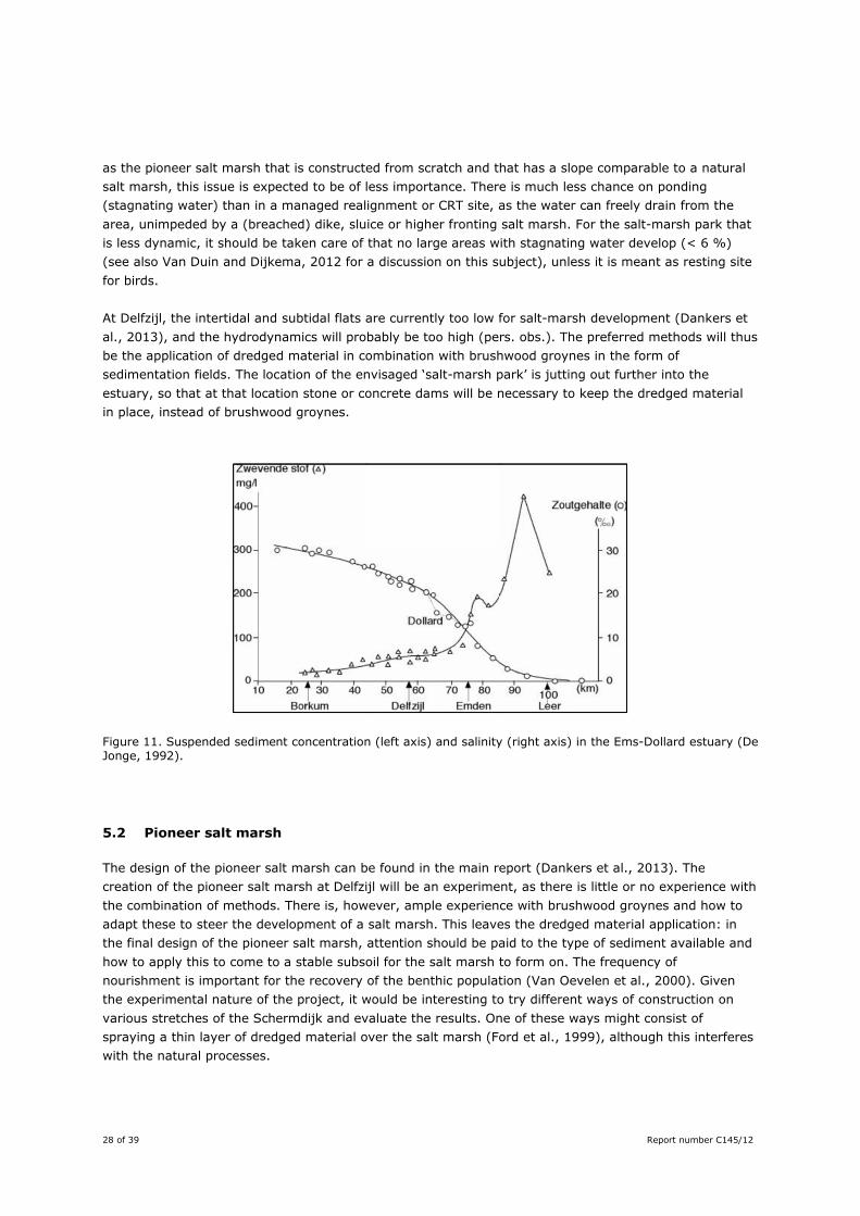
Based on the information in the previous chapter, it seems possible to create salt marshes at Delfzijl in the form of a ‘salt-marsh park’ and ‘pioneer salt marsh’. Delfzijl has a suitable tidal range of 3 m (Rijkswaterstaat, 2012). Average salinity is around 23 promille (Figure 11), which means that compared to the clear salinity gradient in the Scheldt estuary (Van Damme et al., 2005), a salt marsh at Delfzijl would be dominantly saline, with perhaps some brackish species such as in the Dollard. The expected elevation of the vegetation zones at Delfzijl can be calculated from MHT at Delfzijl and the Wadden Sea average elevations for the vegetation zones (Table 1).
Table 1. Elevation of salt-marsh zones expected at Delfzijl, based on the SALT97 classification (De Jong et al., 1998) and MHT at Delfzijl (Rijkswaterstaat, 2012).
Zone Lower limit Upper limit
pioneer zone 95 - 115 cm + NAP (daily flooded)
135 – 150 cm + NAP
low salt marsh 135 – 150 cm + NAP (inundation frequency < 300-150 times per year)
165 – 175 cm + NAP
middle salt marsh 165 – 175 cm + NAP (inundation frequency < 100-70 times per year)
205 cm + NAP
high salt marsh 205 cm + NAP (inundation frequency < 30-20 times per year)
sedimentation occurs up to inundation frequencies of < 5 times per year, 260 cm + NAP
A salt marsh at Delfzijl will probably show average accretion rates of around 0.8 cm per year (average value for the Dollard salt marshes, Esselink et al., 2011) and 1.3 cm per year (average for low and middle marsh of the Groningen north coast, Dijkema et al., 2001). The amount of suspended sediment in the water in the Ems-Dollard (Figure 11) has increased due to anthropogenic activities, and is sufficient for salt-marsh development. The latter is derived from the fact that the Wadden Sea salt marshes do not have a sediment deficit, whereas the general observation is that suspended sediment concentrations in the Wadden Sea are lower than in the Ems. Large salt-marsh areas are about 15 km away, so vegetation dispersal towards Delfzijl should not be a problem and sowing or planting salt-marsh vegetation will not be necessary. Observations of a number of salt-marsh plants on the inside of the Schermdijk confirm this. However, a bottleneck for seed dispersal can be the size of the water inlet (Wolters et al., 2005; Dausse et al., 2008), which should not be a problem in the relatively open ‘pioneer salt marsh’, but needs to be addressed in the ‘salt-marsh park’ that has one opening for water exchange. Dispersal within the salt marsh (Huiskes et al., 1995; Dausse et al., 2008) will most likely not be a problem in the macro-tidal settings of Delfzijl. Fast establishment of the vegetation would be facilitated by having the constructions (especially the dredged material surface) ready when most seeds are being dispersed: in September – December. Risk factors for vegetation establishment and thus salt-marsh functioning are hypersalinity and waterlogging that are reported from MR sites (Wolters et al., 2005; Dausse et al., 2008). In an area such
28 of 39 Report number C145/12
as the pioneer salt marsh that is constructed from scratch and that has a slope comparable to a natural salt marsh, this issue is expected to be of less importance. There is much less chance on ponding (stagnating water) than in a managed realignment or CRT site, as the water can freely drain from the area, unimpeded by a (breached) dike, sluice or higher fronting salt marsh. For the salt-marsh park that is less dynamic, it should be taken care of that no large areas with stagnating water develop (< 6 %) (see also Van Duin and Dijkema, 2012 for a discussion on this subject), unless it is meant as resting site for birds. At Delfzijl, the intertidal and subtidal flats are currently too low for salt-marsh development (Dankers et al., 2013), and the hydrodynamics will probably be too high (pers. obs.). The preferred methods will thus be the application of dredged material in combination with brushwood groynes in the form of sedimentation fields. The location of the envisaged ‘salt-marsh park’ is jutting out further into the estuary, so that at that location stone or concrete dams will be necessary to keep the dredged material in place, instead of brushwood groynes.
Figure 11. Suspended sediment concentration (left axis) and salinity (right axis) in the Ems-Dollard estuary (De Jonge, 1992).
5.2 Pioneer salt marsh
The design of the pioneer salt marsh can be found in the main report (Dankers et al., 2013). The creation of the pioneer salt marsh at Delfzijl will be an experiment, as there is little or no experience with the combination of methods. There is, however, ample experience with brushwood groynes and how to adapt these to steer the development of a salt marsh. This leaves the dredged material application: in the final design of the pioneer salt marsh, attention should be paid to the type of sediment available and how to apply this to come to a stable subsoil for the salt marsh to form on. The frequency of nourishment is important for the recovery of the benthic population (Van Oevelen et al., 2000). Given the experimental nature of the project, it would be interesting to try different ways of construction on various stretches of the Schermdijk and evaluate the results. One of these ways might consist of spraying a thin layer of dredged material over the salt marsh (Ford et al., 1999), although this interferes with the natural processes.
Report number C145/12 29 of 39
5.3 Salt-marsh park
The design of the salt-marsh can be found in the main report (Dankers et al., 2013). The creation of this area is more straightforward, as a similar but larger salt-marsh area of dredged material in a concrete structure was made on the opposite side of the estuary some 40 years ago. Near Krummhörn – Pilsum, a salt-marsh was created in the 70’s by creating a basin using a dam and filling it with dredged material (pers. comm. Jürn Bunje). The result has been disappointing, because part of the area is too high to be a proper salt marsh. Part of the area has been ‘restored’ to increase the quality of the salt marsh, but still the area is mostly a monoculture of Elytrigia, the climax vegetation type. There is a large height difference between the concrete dam and the intertidal flats, so that a proper transition zone is lacking. The main lesson learned from this project is that the proper elevation is a key for salt-marsh (re)creation, and that drainage will establish itself. Given this experience, the experimental side of the park is how to create an area that is accessible for the public, while having salt-marsh characteristics in the larger part of the area. Again, the type of sediment used to construct the area will be important: initial consolidation, mud content and organic matter content will determine how the area will look in the first years. Further, the inlet that connects the area to the estuary should be large enough to allow the free flow of water, sediment and plant seeds. When the slope of the area is in the right direction, the inlet is large enough and the material not too consolidated, the drainage should be able to establish itself. A second opening is considered not feasible as this may affect the stability of the area.
5.4 Naturalness and nature values
Salt marshes are naturally dynamic and develop as a result of the interaction of various processes. It is therefore normal that the salt marsh changes appearance through time and there will always be an element of uncertainty in the outcome of creating a salt marsh. When using flexible techniques, such as those fitting the Building with Nature philosophy, at least the management can be adapted in case targets are not met. The natural dynamics of salt marshes make it only partly possible to predict what the area will look like in future. The brushwood groynes are expected to facilitate sedimentation and vegetation establishment. They need to be extended when new dredged material is added to the area. If the project is successful and the pioneer salt marsh will develop comparable to a natural salt marsh, the vegetation will develop from a pioneer vegetation, with e.g. saltwort, through a mid-successional phase with e.g. Sea aster, to a monoculture of grass. The time this will take depends on the initial elevation of the area and the accretion rate. In case dredged material is used to regularly enlarge the area, new pioneer phases may develop each time. Constructing the salt marsh with a slight slope will give rise to a zonation of vegetation: from pioneer zone bordering the intertidal flats to high marsh next to the dike. Creek formation is expected to start spontaneously, without digging creeks. The creeks will stay more or less in place through time, but will become deeper and the network will become denser. When successful, the pioneer salt marsh will become a semi-natural salt marsh, largely comparable to the salt marshes in the Dollard. The pioneer salt marsh is expected to have a more or less natural drainage pattern, but the soil structure and functioning will probably be less well than on the Dollard marshes because of the use of dredged material. The use of the salt marsh by breeding and foraging birds is hard to predict. Different bird species have different habitat requirements, and they respond strongly to changes in management and to disturbance. By creating the proper abiotic conditions and vegetation structure (the subjects of this study), at least chances for salt-marsh birds are created. However, the planned windmills are a potential disturbance for birds, and disturbance by people cannot be excluded either. More discussion on birds can be found in Appendix 2 of the main report (Dankers et al., 2013).
30 of 39 Report number C145/12
Based on the design (Dankers et al., 2013), about half of the area of the salt-marsh park will consist of salt-marsh like habitat. The nature values of the salt-marsh park will be lower than that of the pioneer salt marsh:
- It lacks dynamics due to the park-like nature of the area - There is not a gradual transition with the intertidal flats, - The soil structure will be artificial, - The use as park will form a strong disturbance for animals.
Finally, the emerging pattern from literature on salt-marsh (re)creation is that, given the right elevation, and sediment and exchange with sea water, a newly (re)created salt marsh may look like a salt marsh with time, with creeks, sedimentation and salt-marsh vegetation. However, functionally a (re)created salt marsh will most likely not fully match a natural salt marsh, and thus not form a one-to-one compensation of natural ones (Van Oevelen et al., 2000). A discussion on the suitability for birds can be found in the main report (Dankers et al., 2013).
5.5 Aspects not taken into account
In this study, the effect of salt marshes on coastal defence was not taken into account. For calculations on that, see the main report (Dankers et al., 2013), or Van Loon-Steensma et al., (2012) and Venema et al., (2012). Another aspect that has not been dealt with is the relation with the larger Ems-Dollard estuary. For as far as the morphology is concerned, this is described in detail in Appendix 3 of the main report (Dankers et al., 2013). From a nature point of view, there are too many uncertainties in the outcome of the project to give reliable predictions. The surface of the to be created salt marshes (15 – 25 ha for the pioneer salt marsh and 10 ha for the salt-marsh park) is relatively small compared to the 714 ha that is covered by the salt marshes in the Dollard (Esselink et al., 2011). The intended location at a stretch of coast without any salt marshes at present is however favourable. The Natura 2000 legislation imposes restrictions to the reduction of existing habitat types, such as intertidal flats, in favour of creating other habitats such as salt marshes. Salt-marsh creation projects that advance onto the tidal flats are therefore generally considered being less positive for an estuary than projects that add area to the estuary (Van Oevelen et al., 2000). Ways to deal with the N2000 legislation are being studied, for example Mendelts and Boerema, 2011; Baptist et al., 2012, but these are still under construction. The effect of the Griesberg sediment on the salt marsh is hard to predict. There has been some study done on salt-marsh plants related to waste products from soda factories (Piernik, 2003; Piernik, 2005). The vegetation responded well to the alkaline soil, but this was at much lower pH values than measured at the Griesberg (Oranjewoud, 2010). Seeing that soil fauna was present when there was sufficient other sediment on top of the gries material (Baptist and De Groot, 2012, included as Appendix 1 of the main report Dankers et al., 2013), the Griesberg at its present location should not have a large negative effect on an envisaged salt marsh. The effect on overall water quality could not be determined based on the survey.
Report number C145/12 31 of 39
6 Conclusions
6.1 Factors of importance when creating a salt marsh
1. Salt-marsh development occurs naturally as the interplay between biotic and abiotic processes. Creating or restoring a salt marsh therefore requires creating the boundary conditions so that these natural processes can take place. Only then may the functioning and nature values of a (re)created salt marsh approach those of a natural salt marsh. As salt marshes are dynamic by nature, some goals may only be reached after some time and the appearance of the area will change through time.
2. Important factors are: a. Elevation with respect to the tidal frame b. Hydrodynamics c. Drainage d. Sediment composition e. Vegetation establishment.
6.2 Most suitable methods for creating a new salt marsh at this location
1. It seems possible to create a salt marsh at Delfzijl, as tidal range, vegetation and suspended sediment are suitable for the occurrence of salt marshes.
2. The elevation of the intertidal and subtidal area needs to be raised to around mean high tide, for example with dredged material. This sediment should be unpolluted and contain at least some fine-grained fraction and preferably also some organic matter. The slope should be seaward and around 1:100.
3. Further, it will most likely be necessary to create shelter against the hydrodynamic forces so that vegetation will establish. Brushwood groynes represent a method that is flexible and matches local cultural history, that would be suitable for the creation of the pioneer salt marsh. The salt-marsh park will stick out into the estuary further, so that the hydrodynamics surrounding it are expected to be stronger. In that case, harder constructions such as stone dams are probably necessary.
4. Digging drainage channels does not seem to be necessary, but monitoring is advisable to check the autonomous development of the drainage.
5. Vegetation is expected to spontaneously disperse to the sites because of sufficient source material present in the area. Depending on the desired functioning of the salt marsh, some form of vegetation management may be necessary, such as mowing or grazing.
6. Risk factors for a successful project include: constructing a salt marsh that is either too small, too high, too low, or that has persisting artificial drainage, stagnating water, an abrupt transition to the intertidal flats, or too much disturbance. The design should pay attention to those aspects of elevation and drainage.
7. For any project such as the creation of a salt marsh, firstly clear goals have to be set. Then, the area needs to be monitored carefully to evaluate whether these objectives are met. If not, management can be adapted. Building with Nature solutions, such as using sediment and brushwood groynes to get salt-marsh development going, are well suited for such adaptive management.
These aspects have been taken account in the design of the salt-marsh park and pioneer salt marsh at Delfzijl, given in Dankers et al., (2013).
32 of 39 Report number C145/12
6.3 What naturalness and nature values can be achieved, and how
1. As soon as the elevation of the areas is suitable and shelter has been created, the areas are expected to colonise rapidly with vegetation and show vertical accretion.
2. However, such salt marshes will most likely be semi-natural, as it has been shown that only occasionally full salt-marsh functioning is reached in a reconstructed salt marsh.
3. What may be expected, though, is the presence of various typical salt-marsh plants, a location for birds to rest at high tide and possibly breeding of birds on the higher parts of the salt marsh.
Acknowledgements This study was financed by the Gemeente Delfzijl as part of the Marconi project, and is also part of the innovation programme Building with Nature. The latter programme is financed from a number of sources, among which the Subsidieregeling Innovatieketen Water (SIW, Staatscourant nrs. 953 en 17009) of the Ministery of Infrastructure & Environment en contributions of the members of the Stichting EcoShape. The programme receives co-financing from the European Regional Development Fund (EFRO) and the Municipality of Dordrecht.
Report number C145/12 33 of 39
References Allen, J.R.L., 1990. Salt-Marsh Growth and Stratification - A Numerical-Model with Special Reference to the
Severn Estuary, Southwest Britain. Marine Geology, 95(2): 77-96. Allen, J.R.L., 2000. Morphodynamics of Holocene salt marshes: a review sketch from the Atlantic and Southern
North Sea coasts of Europe. Quaternary Science Reviews, 19(12): 1155-1231. Andresen, H., Bakker, J.P., Brongers, M., Heydemann, B., Irmler, U., 1990. Long-Term Changes of Salt-Marsh
Communities by Cattle Grazing. Vegetatio, 89(2): 137-148. Bakker, J.P., Bos, D., De Vries, Y., 2000. To graze or not to graze: that is the question. In: W.J. Wolff, K.
Essink, A. Kellerman and M.A. Van Leeuwe (Editors). Proceedings of the 10th international scientific wadden sea symposium. Ministery of agriculture, nature management and fisheries, Department of Marine Biology, University of Groningen, Groningen, pp. 67-88.
Bakker, J.P., Esselink, P., Dijkema, K.S., Van Duin, W.E., De Jong, D.J., 2002. Restoration of salt marshes in the Netherlands. Hydrobiologia, 478(1-3): 29-51.
Baptist, M.J., De Groot, A.V., 2012. Ecologische bemonstering griesberg, Delfzijl. IMARES C143/12, IMARES, EcoShape - Building with Nature.
Baptist, M.J., Dijkema, K.S., Van Duin, W.E., Smit, C.J., 2012. Een ruimere jas voor natuurontwikkeling in de Waddenzee, uitgewerkt voor een casus Afsluitdijk. Rapport C084/12, IMARES, Wageningen UR, Texel.
Beck, M.W., Brumbaugh, R.D., Airoldi, L., Carranza, A., Coen, L.D., Crawford, C., Defeo, O., Edgar, G.J., Hancock, B., Kay, M.C., Lenihan, H.S., Luckenbach, M.W., Toropova, C.L., Zhang, G.F., Guo, X.M., 2011. Oyster Reefs at Risk and Recommendations for Conservation, Restoration, and Management. Bioscience, 61(2): 107-116.
Bos, D., Bakker, J.P., De Vries, Y., Van Lieshout, S., 2002. Long-term vegetation changes in experimentally grazed and ungrazed back-barrier marshes in the Wadden Sea. Applied Vegetation Science, 5(1): 45-54.
Cahoon, D.R., Day, J.W., Reed, D.J., 1999. The influence of surface and shallow subsurface soil processes on wetland elevation: a synthesis. Current Topics in Wetland Biochemistry, 3: 72-88.
Cecconi, G., 2009. Beneficial Reuse and Morphological Restoration, SedNet Conference 2009, Hamburg, Germany.
Chang, E.R., Veeneklaas, R.M., Bakker, J.P., 2007. Seed dynamics linked to variability in movement of tidal water. Journal of Vegetation Science, 18(2): 253-262.
Crooks, S., Schutten, J., Sheern, G.D., Pye, K., Davy, A.J., 2002. Drainage and Elevation as Factors in the Restoration of Salt Marsh in Britain. Restoration Ecology, 10(3): 591-602.
D'Alpaos, A., Lanzoni, S., Marani, M., Bonometto, A., Cecconi, G., Rinaldo, A., 2007. Spontaneous tidal network formation within a constructed salt marsh: Observations and morphodynamic modelling. Geomorphology, 91(3–4): 186-197.
Dankers, P., Verhoogt, H., Van Nieuwerburgh, L., Akkerman, G.J., Peerbolte, B., Schaafsma, M., Voerman, A., Kanger, W., Grasmeijer, B., De Groot, A.V., Baptist, M.J., Smit, C., 2013. Ecodynamische Variantenanalyse Kustontwikkeling Delfzijl; Onderzoek naar mogelijkheden van strand- en kwelderaanleg, Nijmegen.
Dausse, A., Bonis, A., Bouzille, J.B., Lefeuvre, J.C., 2008. Seed dispersal in a polder after partial tidal restoration: Implications for salt-marsh restoration. Applied Vegetation Science, 11(1): 3-12.
De Groot, A.V., van Wesenbeeck, B.K., Van Loon-Steensma, J.M., 2013. Stuurbaarheid van kwelders, IMARES Wageningen UR, IJmuiden etc.
De Groot, A.V., Veeneklaas, R.M., Kuijper, D.P.J., Bakker, J.P., 2011. Spatial patterns in accretion on barrier-island salt marshes. Geomorphology, 134(3-4): 280-296.
De Jong, D.J., Dijkema, K.S., Bossinade, J.H., Janssen, J.A.M., 1998. SALT97; een classificatieprogramma voor kweldervegetaties, Rijkswaterstaat, IBN-DLO.
De Jonge, V.N., 1992. Physical processes and dynamics of microphytobenthos in the Ems estuary (The Netherlands), De Jonge, [S.l.].
De Leeuw, J., De Munck, W., Olff, H., Bakker, J.P., 1993. Does Zonation Reflect the Succession of Salt-Marsh Vegetation - A Comparison of An Estuarine and A Coastal Bar Island Marsh in the Netherlands. Acta Botanica Neerlandica, 42(4): 435-445.
34 of 39 Report number C145/12
Dijkema, K.S., 1987. Changes in salt-marsh area in the Netherlands Wadden Sea after 1600. In: A. Huiskes, C.W.P.M. Blom and J. Rozema (Editors), Vegetation between land and sea. Dr. W. Junk Publishers, Dordrecht/Boston/Lancaster, pp. 42-49.
Dijkema, K.S., 1990. Salt and Brackish Marshes Around the Baltic Sea and Adjacent Parts of the North-Sea - Their Vegetation and Management. Biological Conservation, 51(3): 191-209.
Dijkema, K.S., 2005. Kwelders en schoren in de Kaderrichtlijn water : ontwikkeling van potentiële referenties en van potentiële goede ecologische toestanden. RIKZ;2005.020. Rijkswaterstaat [etc.], [S.l.] [etc.].
Dijkema, K.S., Bossinade, J.H., Bouwsema, P., De Glopper, R.J., Beukema, J.J., 1990. Salt marshes in the Netherlands Wadden Sea: rising high-tide levels and accretion enhancement Expected Effects of Climatic Change on Marine Coastal Ecosystems. Kluwer Academic Publishers, pp. 173-188.
Dijkema, K.S., Bossinade, J.H., van den Bergs, J., 1991. Natuurtechnisch beheer van kwelderwerken in de Friese en Groninger Waddenzee : greppelonderhoud en overig grondwerk. Nota / Rijkswaterstaat, Directie Groningen;GRAN 1991-2002. Rijkswaterstaat, Directie Groningen [etc.], [Groningen etc.].
Dijkema, K.S., Nicolai, A., De Vlas, J., Jongerius, H., Nauta, H., 2001. Van landaanwinning naar kwelderwerken. Rijkswaterstaat, Directie Noord-Nederland, Leeuwarden.
Dijkema, K.S., van Duin, W.E., Dijkman, E.M., van Leeuwen, P.W., 2008. Monitoring van kwelders in de Waddenzee: rapport in het kader van het WOT programma Informatievoorziening Natuur i.o. (WOT IN). Alterra-rapport 1574. Alterra, Wageningen.
Doody, J.P., 2008. Saltmarsh Conservation, Management and Restoration : Coastal Systems and Continental Margins. Coastal Systems and Continental Margins 12. Springer, Dordrecht.
Elliott, M., Burdon, D., Hemingway, K.L., Apitz, S.E., 2007. Estuarine, coastal and marine ecosystem restoration: Confusing management and science – A revision of concepts. Estuarine, Coastal and Shelf Science, 74(3): 349-366.
Erchinger, H.F., 1985. Dünen, Watt und Salzwiesen: Schutz u. Erhaltung v. Küste u. Inseln, Tier- u. Pflanzenwelt, Nieders. Min. f. Ernährung, Landwirtschaft u. Forsten, Hannover.
Erfanzadeh, R., Garbutt, A., Pétillon, J., Maelfait, J.-P., Hoffmann, M., 2010. Factors affecting the success of early salt-marsh colonizers: seed availability rather than site suitability and dispersal traits. Plant Ecology, 206(2): 335-347.
Esselink, P., Bos, D., Oost, A.P., Dijkema, K.S., Bakker, R., De Jong, R., 2011. Verkenning afslag Eems-Dollardkwelders. PUCCIMAR rapport 02, A&W rapport 1574. http://www.waddenzee.nl/fileadmin/content/Dossiers/Natuur_en_Landschap/pdf/Rapp_Dollardkwelders_2012.pdf
Esselink, P., Dijkema, K.S., Reents, S., Hageman, G., 1998. Vertical accretion and profile changes in abandoned man-made tidal marshes in the Dollard estuary, the Netherlands. Journal of Coastal Research, 14(2): 570-582.
Esselink, P., Fresco, L.F.M., Dijkema, K.S., 2002. Vegetation change in a man-made salt marsh affected by a reduction in both grazing and drainage. Applied Vegetation Science, 5(1): 17-32.
Esselink, P., Petersen, J., Arens, S., Bakker, J.P., Bunje, J., Dijkema, K.S., Hecker, N., Hellwig, U., Jensen, A.-V., Kers, A.S., Körber, P., Lammerts, E.J., Stock, M., Veeneklaas, R.M., Vreeken, M., Wolters, M., 2009. Salt Marshes. In: H. Marencic and J. De Vlas (Editors), Quality Status Report 2009. Wadden Sea Ecosystem. Common Wadden Sea Secretariat (CWSS), Wilhelmshaven, Germany; Trilateral Monitoring and Assessment Group (TMAG), Wilhelmshaven, pp. 54.
Esselink, P., Zijlstra, W., Dijkema, K.S., Van Diggelen, R., 2000. The effects of decreased management on plant-species distribution patterns in a salt marsh nature reserve in the Wadden Sea. Biological Conservation, 93(1): 61-76.
Ford, M.A., Cahoon, D.R., Lynch, J.C., 1999. Restoring marsh elevation in a rapidly subsiding salt marsh by thin-layer deposition of dredged material. Ecological Engineering, 12(3-4): 189-205.
French, C.E., French, J.R., Clifford, N.J., Watson, C.J., 2000. Sedimentation-erosion dynamics of abandoned reclamations: the role of waves and tides. Continental Shelf Research, 20(12-13): 1711-1733.
French, J.R., 2006a. Tidal marsh sedimentation and resilience to environmental change: Exploratory modelling of tidal, sea-level and sediment supply forcing in predominantly allochthonous systems. Marine Geology, 235(1-4): 119-136.
French, J.R., Stoddart, D.R., 1992. Hydrodynamics of salt marsh creek systems: implications for marsh morphological development and material exchange. Earth Surface Processes & Landforms, 17(3): 235-252.
Report number C145/12 35 of 39
French, P.W., 2001. Coastal defences : processes, problems and solutions. Routledge, London [etc.]. French, P.W., 2006b. Managed realignment - The developing story of a comparatively new approach to soft
engineering. Estuarine, Coastal and Shelf Science, 67(3): 409-423. Friedrichs, C.T., Perry, J.E., 2001. Tidal salt marsh morphodynamics: a synthesis. Journal of Coastal Research,
SI, No. 27: 7-37. Friess, D.A., Krauss, K.W., Horstman, E.M., Balke, T., Bouma, T.J., Galli, D., Webb, E.L., 2012a. Are all
intertidal wetlands naturally created equal? Bottlenecks, thresholds and knowledge gaps to mangrove and saltmarsh ecosystems. Biological Reviews, 87(2): 346-366.
Friess, D.A., Möller, I., Spencer, T., 2008. Managed realignment and the re-establishment of saltmarsh habitat, Freiston Shore, Lincolnshire, United Kingdom. Prepared for the report 'The Role of Environmental Management and Eco-Engineering in Disaster Risk Reduction and Climate Change Adaptation'.
Friess, D.A., Spencer, T., Smith, G.M., Möller, I., Brooks, S.M., Thomson, A.G., 2012b. Remote sensing of geomorphological and ecological change in response to saltmarsh managed realignment, The Wash, UK. International Journal of Applied Earth Observation and Geoinformation, 18(0): 57-68.
Garbutt, A., Wolters, M., 2008. The natural regeneration of salt marsh on formerly reclaimed land. Applied Vegetation Science, 11(3): 335-344.
Gedan, K.B., Kirwan, M.L., Wolanski, E., Barbier, E.B., Silliman, B.R., 2011. The present and future role of coastal wetland vegetation in protecting shorelines: answering recent challenges to the paradigm. Climatic Change, 106(1): 7-29.
Hofstede, J.L.A., 2003. Integrated management of artificially created salt marshes in the Wadden Sea of Schleswig-Holstein, Germany. Wetlands Ecology and Management, 11(3): 183-194.
Houwing, E.J., Houwing, E.-J., van Duin, W.E., Waaij, Y.S.-v.d., Dijkema, K.S., Terwindt, J.H.J., 1999. Biological and abiotic factors influencing the settlement and survival of Salicornia dolichostachya in the intertidal pioneer zone. Mangroves and Salt Marshes, 3(4): 197-206.
Huiskes, A.H.L., Koutstaal, B.P., Herman, P.M.J., Beeftink, W.G., Markusse, M.M., Munck, W.D., 1995. Seed Dispersal of Halophytes in Tidal Salt Marshes. Journal of Ecology, 83(4): 559-567.
Karle, M., Bartholomä, A., 2008. Salt marsh sediments as natural resources for dike construction — sediment recycling in clay pits. Marine Biodiversity, 38(2): 83-92.
Kornman, B.A., 2000. Het Sieperdaschor; Tien jaar morfologische ontwikkeling in vogelvlucht, lessen voor de toekomst. RIKZ/OS/2000.850x, Rijkswaterstaat.
Langlois, E., Bonis, A., Bouzille, J.B., 2001. The response of Puccinellia maritima to burial: A key to understanding its role in salt-marsh dynamics? Journal of Vegetation Science, 12(2): 289-297.
Langlois, E., Bonis, A., Bouzille, J.B., 2003. Sediment and plant dynamics in saltmarshes pioneer zone: Puccinellia maritima as a key species? Estuarine Coastal and Shelf Science, 56(2): 239-249.
Mendelts, P., Boerema, L., 2011. Een ruimere jas binnen N2000; de mogelijkheden voor een ecosysteembenadering voor de vergunningverlening onder de Nb-wet. project nr. 5129, Eelerwoude, Diever.
Mossman, H.L., Davy, A.J., Grant, A., 2012. Does managed coastal realignment create saltmarshes with ‘equivalent biological characteristics’ to natural reference sites? Journal of Applied Ecology, 49: 1446-1456.
Mulder, H.P.J., 1998. Geomorfologische en hydrologische ontwikkelingen. In: K. Essink and P. Esselink (Editors), Het Eems-Dollard estuarium: interacties tussen menselijke beïnvloeding en natuurlijke dynamiek. Rijksinstituut voor Kust en Zee, Haren, pp. 25-45.
Nakamura, Y., 2006. Restoration activities of tidal flats in Japan, ICEC 2006; Second International Conference on Estuaries & Coasts Guangzhou, China.
Olff, H., De Leeuw, J., Bakker, J.P., Platerink, R.J., Van Wijnen, H.J., De Munck, W., 1997. Vegetation succession and herbivory in a salt marsh: changes induced by sea level rise and silt deposition along an elevational gradient. Journal of Ecology, 85(6): 799-814.
Oranjewoud, 2010. Onderzoeksrapport Samenstelling Griesberg Brunner Mond, Rijkswaterstaat Noord Nederland.
Pétillon, J., Garbutt, A., 2008. Success of managed realignment for the restoration of salt-marsh biodiversity: preliminary results on ground-active spiders. Journal of Arachnology, 36(2): 388-393.
Piernik, A., 2003. Inland halophilous vegetation as indicator of soil salinity. Basic and Applied Ecology, 4(6): 525-536.
36 of 39 Report number C145/12
Piernik, A., 2005. Vegetation-environment relations on inland saline habitats in Central Poland. Phytocoenologia, 35(1): 19-38.
Pilkey, O.H., Wright, H.L.I., 1988. Seawalls Versus Beaches. Journal of Coastal Research: 41-64. Ranwell, D.S., 1972. Ecology of salt marshes and sand dunes. Chapman and Hall, London. Rijkswaterstaat, 2012. Referentiewaarden waterstanden. Rijkswaterstaat. Scarton, F., Day Jr, J.W., Rismondo, A., Cecconi, G., Are, D., 2000. Effects of an intertidal sediment fence on
sediment elevation and vegetation distribution in a Venice (Italy) lagoon salt marsh. Ecological Engineering, 16(2): 223-233.
Schrama, M.J.J., 2012. The assembly of a saltmarsh ecosystem: the interplay of green and brown food webs. PhD. Thesis, University of Groningen, Groningen.
Schröder, H.K., Kiehl, K., Stock, M., 2002. Directional and non-directional vegetation changes in a temperate salt marsh in relation to biotic and abiotic factors. Applied Vegetation Science, 5(1): 33-44.
Scyphers, S.B., Powers, S.P., Heck Jr, K.L., Byron, D., 2011. Oyster reefs as natural breakwaters mitigate shoreline loss and facilitate fisheries. PLoS ONE, 6(8): e22396.
Shafer, D.J., Streever, W.J., 2000. A comparison of 28 natural and dredged material salt marshes in Texas with an emphasis on geomorphological variables. Wetlands Ecology and Management, 8(5): 353-366.
Short, F.T., Burdick, D.M., Short, C.A., Davis, R.C., Morgan, P.A., 2000. Developing success criteria for restored eelgrass, salt marsh and mud flat habitats. Ecological Engineering, 15(3–4): 239-252.
Spencer, K.L., Harvey, G.L., 2012. Understanding system disturbance and ecosystem services in restored saltmarshes: Integrating physical and biogeochemical processes. Estuarine, Coastal and Shelf Science, 106(0): 23-32.
Stagg, C.L., Mendelssohn, I.A., 2010. Restoring Ecological Function to a Submerged Salt Marsh. Restoration Ecology, 18: 10-17.
Stagg, C.L., Mendelssohn, I.A., 2011. Controls on resilience and stability in a sediment-subsidized salt marsh. Ecological Applications, 21(5): 1731-1744.
Streever, W.J., 2000. Spartina alterniflora marshes on dredged material: a critical review of the ongoing debate over success. Wetlands Ecology and Management, 8(5): 295-316.
Suchrow, S., Jensen, K., 2010. Plant species responses to an elevational gradient in German North Sea salt marshes. Wetlands, 30(4): 735-746.
Temmerman, S., Bouma, T.J., Van de Koppel, J., Van der Wal, D.D., De Vries, M.B., Herman, P.M.J., 2007. Vegetation causes channel erosion in a tidal landscape. Geology, 35(7): 631-634.
U.S.A.C.E., 2008. Coastal Engineering Manual, U.S. Army Corps of Engineers. http://140.194.76.129/publications/eng-manuals/
Van Damme, S., Struyf, E., Maris, T., Ysebaert, T., Dehairs, F., Tackx, M., Heip, C., Meire, P., 2005. Spatial and temporal patterns of water quality along the estuarine salinity gradient of the Scheldt estuary (Belgium and The Netherlands): results of an integrated monitoring approach. Hydrobiologia, 540(1): 29-45.
Van Duin, W.E., Dijkema, K.S., 2003. Proef met de onderhoudsarme ontwatering in de kwelderwerken: 'De Krekenproef' : evaluatie 1997-2002. Alterra-rapport;634. Alterra, Research Instituut voor de Groene Ruimte, Wageningen.
Van Duin, W.E., Dijkema, K.S., 2012. Randvoorwaarden voor kwelderontwikkeling in de Waddenzee en aanzet voor een kwelderkansenkaart, IMARES Wageningen UR, IJmuiden [etc.]. http://edepot.wur.nl/220052
Van Duin, W.E., Dijkema, K.S., Bos, D., 2007. Cyclisch beheer kwelderwerken Friesland. A&W-rapport;887. IMARES [etc.], Wageningen [etc.].
Van Loon-Steensma, J.M., De Groot, A.V., Van Duin, W.E., Van Wesenbeeck, B.K., Smale, A.J., 2012. Verkenning bijdrage kwelders aan waterveiligheid in het Waddengebied; Een verkenning naar locaties in het Waddengebied waar bestaande kwelders en kwelderontwikkeling mogelijk kunnen bijdragen aan waterveiligheid, Alterra, IMARES, Deltares.
Van Loon-Steensma, J.M., Slim, P.A., accepted. The impact of erosion protection by stone dams on salt-marsh vegetation on two Wadden Sea barrier islands. Journal of Coastal Research.
Van Oevelen, D., Van den Bergh, E., Ysebaert, T., Meire, P., 2000. Literatuuronderzoek naar estuariene herstelmaatregelen. Rapport / Instituut voor Natuurbehoud;IN.R. 2000.4. Instituut voor Natuurbehoud [etc.], Brussel [etc.].
Vandenbruwaene, W., Maris, T., Cox, T.J.S., Cahoon, D.R., Meire, P., Temmerman, S., 2011. Sedimentation and response to sea-level rise of a restored marsh with reduced tidal exchange: Comparison with a natural tidal marsh. Geomorphology, 130(3-4): 115-126.
Report number C145/12 37 of 39
Vandenbruwaene, W., Meire, P., Temmerman, S., 2012. Formation and evolution of a tidal channel network within a constructed tidal marsh. Geomorphology, 151-152: 114-125.
Venema, J.E., Schelfhout, H.A., Moerman, E., Van Duren, L.A., 2012. Kwelders en dijkveiligheid in het Waddengebied, Deltares, Delft.
Vijverberg, T., Damsma, T., Tangelder, M., Van Raalte, G., Van Koningsveld, M., 2012. BwN - Knowledge - Managed Realignment Schemes.
Viles, H., Spencer, T., 1995. Coastal Problems; Geomorphology, Ecology and Society at the Coast. Arnold, London
Williams, P.B., Faber, P.B., 2001. Salt Marsh Restoration Experience in San Francisco Bay. Journal of Coastal Research(Special Issue No. 27): 203-311.
Williams, P.B., Orr, M.K., 2002. Physical Evolution of Restored Breached Levee Salt Marshes in the San Francisco Bay Estuary. Restoration Ecology, 10(3): 527-542.
Wolters, M., Garbutt, A., Bakker, J.P., 2005. Salt-marsh restoration: Evaluating the success of de-embankments in north-west Europe. Biological Conservation, 123(2): 249-268.
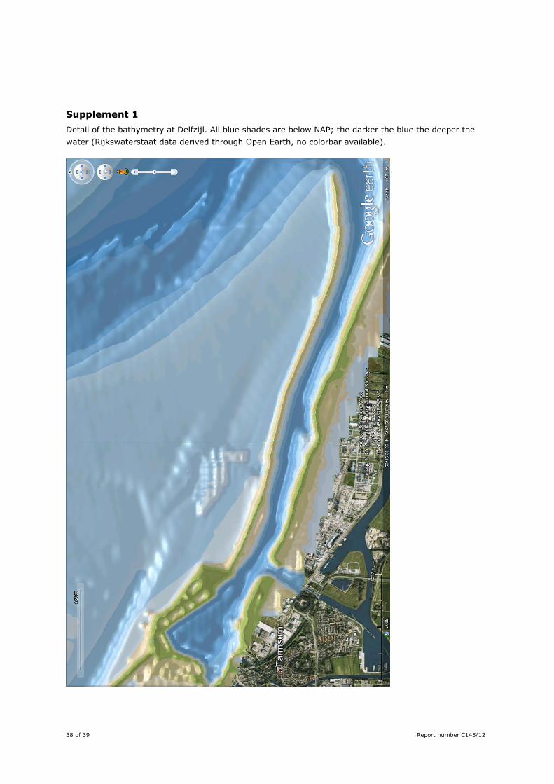
38 of 39 Report number C145/12
Supplement 1 Detail of the bathymetry at Delfzijl. All blue shades are below NAP; the darker the blue the deeper the water (Rijkswaterstaat data derived through Open Earth, no colorbar available).
Report number C145/12 39 of 39
Justification A.V. de Groot, 2012. Best practices for creating new salt marshes in a saline estuarine setting, a literature study. IMARES rapport C145/12 for EcoShape Building with Nature. Project Number: OK0.3 Marconi Delfzijl Onderdeel van project 4306111069 The scientific quality of this report has been peer reviewed by the a colleague scientist and the head of the department of IMARES. Approved: dr. M.J.C. Rozemeijer researcher
Signature: Date: 15 January 2013 Approved: drs. J. Asjes manager
Signature: Date: 15 January 2013