Embed Size (px)
Citation preview

WATER QUALITY SURVEY SUMMARY FOR THE
UPPER RIO GRANDE WATERSHED, PART II (BETWEEN NORTH OF EMBUDO CREEK AND ANGOSTURA DIVERSION)
2001
Prepared by
Surface Water Quality Bureau New Mexico Environment Department
August 2004

This page left intentionally blank.
Upper Rio Grande Watershed, Part II Summary May – October 2001
TABLE OF CONTENTS TABLE OF CONTENTS
LIST OF TABLES 1.0 EXECUTIVE SUMMARY 2.0 INTRODUCTION 3.0 NM WATER QUALITY STANDARDS 4.0 METHODS 5.0 SAMPLING SUMMARY 6.0 WATER QUALITY ASSESSMENT (RESULTS AND DISCUSSION)
6.1 Assessment Units (Stream Reach) 6.2 Discussion of Exceedences of Water Quality Standards
7.0 CONCLUSIONS 8.0 REFERENCES

Upper Rio Grande Watershed, Part II Summary May – October 2001
LIST OF TABLES
Table 1. Sampling Stations Table 2. Assessment Units and Associated Sampling Stations Table 3. Water Quality Exceedences

Upper Rio Grande Watershed, Part II Summary May – October 2001
1.0 EXECUTIVE SUMMARY
Water quality surveys and assessments are completed in fulfillment of Section 106 of the Clean Water Act (CWA), Work Program for Water Quality Management. The purpose of the water quality survey is to collect water quality data to identify and prioritize water quality problems within a watershed and to evaluate the effectiveness of water quality based controls. The data collected as part of the survey are compared to current United State Environmental Protection Agency (USEPA) approved water quality standards to determine if waterbodies throughout the watershed are supporting their designated uses, such as the fishable and swimmable goals set forth in the CWA §102(a). Water Quality Survey Summary Reports focus on information and data collected by the New Mexico Environment Department’s (NMED) Surface Water Quality Bureau (SWQB) pertaining to stream reaches that were identified as NOT meeting water quality standards. All data collected as part of a survey are available upon request to the SWQB and can be downloaded from USEPA’s computerized environmental data system known as STORET (http://www.epa.gov/storet/). The data collected as part of this study are later combined with all other readily available or submitted data that meet state quality assurance/quality control requirements to form the basis of designated use attainment determinations summarized in the Integrated CWA §303(d)/305(b) Water Quality Monitoring and Assessment Report. The most common water quality exceedences and/or impairments identified as part of this study of the upper Rio Grande watershed between Embudo Creek and the Angostura Diversion were for turbidity. Aluminum was exceeded in the portions of the mainstem of the Rio Grande sampled as part of this study; however, the exceedences were not significant enough to classify the waterbody as impaired due to aluminum. The Rio Grande is impaired due to turbidity from Cochiti Reservoir to Embudo Station and biologically impaired from Santa Clara to Embudo Creek. Galisteo Creek, in the southern portion of the study area is impaired due to temperature and conductivity; however, the creek may be misclassified as a high quality coldwater fishery due to the fact that some portions of the creek go dry at times. Turbidity and mercury exceedences were also observed in these tributaries; however, they were not significant enough to be considered impaired due to these parameters. In the Los Alamos area, Pueblo Canyon, Mortandad Canyon, and Pajarito Canyon were all considered impaired due to gross alpha and selenium, and Pajarito Canyon was also impaired due to mercury. The selenium levels may be elevated due to the effects of the Cerro Grande fire. The Rito de los Frijoles was the most impaired waterbody in this portion of the study area and is impaired due to temperature, dichlorodiphenyltrichloroethane (DDT), fecal coliform and turbidity. Finally, Capulin Creek is biologically impaired and impaired due to stream bottom deposits. As you move up the watershed, the Pojoaque River is impaired due to stream bottom deposits and also had minor exceedences of aluminum, dissolved oxygen, temperature, and turbidity. In the Tesuque tributaries, water quality impairments exist for aluminum, conductivity, and turbidity. In the Chimayo area the only water quality impairment identified was for turbidity on

Upper Rio Grande Watershed, Part II Summary May – October 2001
the Rio Quemado, although there were also minor exceedences of aluminum, conductivity, and turbidity in some of these tributaries. In the upper portion of the study area water quality is biologically impaired and impaired due to turbidity on portions of the Rio Pueblo, Rio Santa Barbara, and Embudo Creek. Embudo Creek is also impaired due to stream bottom deposits. Minor exceedences were also observed in these tributaries for aluminum, conductivity, and turbidity.

2.0 INTRODUCTION
From May to October 2001, the Surface Water Quality Bureau (SWQB) of the New Mexico Environment Department (NMED) conducted a series of multiple-day intensive water quality surveys of the upper Rio Grande watershed. The survey included the geographic area draining into a portion of the Rio Grande located from just north of Embudo Creek (approximately 87 river miles upstream of Albuquerque) to near the Angostura Diversion (approximately 19 river miles above Albuquerque) and will be referred to as Part II of the upper Rio Grande watershed study. The Rio Chama sub-watershed and portions of the Santa Fe sub-watershed were excluded from this survey, as they were surveyed in separate studies. The study area extends more than 85 miles from north to south and more than 55 miles east-to-west. Land uses in this 2900 sq. mi. drainage consist of dry land and irrigated agriculture (including orchards), grazing, recreation (including designated wilderness), and urban development. The Los Alamos National Laboratory, cities including Santa Fe and Espanola, Native American lands, and extensive public lands (including Bandelier National Monument) are located within this watershed.
3.0 NM WATER QUALITY STANDARDS
General standards and standards applicable to attainable or designated uses for portions of the upper Rio Grande watershed that were surveyed in this study are set forth in sections 20.6.4.12 and 20.6.4.900, of Standards for Interstate and Intrastate Surface Waters (20.6.4 NMAC, October 11, 2002). Segment specific standards for the upper Rio Grande watershed are set forth in Sections 20.6.4.110, 20.6.4.114, 20.6.4.121, and 20.6.4.123 and read as follows:
20.6.4.110 RIO GRANDE BASIN - The main stem of the Rio Grande from Angostura diversion works upstream to Cochiti dam. A. Designated Uses: irrigation, livestock watering, wildlife habitat, secondary contact, coldwater fishery, and warmwater fishery. B. Standards: (1) In any single sample: pH shall be within the range of 6.6 to 9.0, and temperature shall not exceed 25°C (77°F). The use-specific numeric standards set forth in 20.6.4.900 NMAC are applicable to the designated uses listed above in Subsection A of this section. (2) The monthly geometric mean of fecal coliform bacteria shall not exceed 200/100 mL; no single sample shall exceed 400/100 mL (see Subsection B of 20.6.4.13 NMAC). [20.6.4.110 NMAC – Rp 20 NMAC 6.1.2108, 10-12-00] 20.6.4.114 RIO GRANDE BASIN - The main stem of the Rio Grande from the headwaters of Cochiti reservoir upstream to Taos Junction bridge, Embudo creek from its mouth on the Rio Grande upstream to the junction of the Rio Pueblo and the Rio Santa Barbara, the Santa Cruz river below Santa Cruz dam, the Rio Tesuque below the Santa Fe national forest and the Pojoaque river below Nambe dam. A. Designated Uses: irrigation, livestock watering, wildlife habitat, marginal coldwater fishery, primary contact, and warmwater fishery. B. Standards:

Upper Rio Grande Watershed, Part II Summary May – October 2001
(1) In any single sample: pH shall be within the range of 6.6 to 9.0, temperature shall not exceed 22°C (71.6°F), and turbidity shall not exceed 50 NTU. The use-specific numeric standards set forth in 20.6.4.900 NMAC are applicable to the designated uses listed above in Subsection A of this section. (2) The monthly geometric mean of fecal coliform bacteria shall not exceed 200/100 mL; no single sample shall exceed 400/100 mL (see Subsection B of 20.6.4.13 NMAC). (3) At mean monthly flows above 100 cfs, the monthly average concentration for: TDS shall not exceed 500 mg/L, sulfate shall not exceed 150 mg/L, and chloride shall not exceed 25 mg/L. [20.6.4.114 NMAC – Rp 20 NMAC 6.1.2111, 10-12-00] 20.6.4.121 RIO GRANDE BASIN - Perennial tributaries to the Rio Grande in Bandelier national monument and their headwaters in Sandoval county, all perennial reaches of tributaries to the Rio Grande in Santa Fe county unless included in other segments. A. Designated Uses: domestic water supply, high quality coldwater fishery, irrigation, livestock watering, wildlife habitat, municipal and industrial water supply, secondary contact, and primary contact. B. Standards: (1) In any single sample: conductivity shall not exceed 300 µmhos, pH shall be within the range of 6.6 to 8.8, temperature shall not exceed 20°C (68°F), and turbidity shall not exceed l0 NTU. The use-specific numeric standards set forth in 20.6.4.900 NMAC are applicable to the designated uses listed above in Subsection A of this section. (2) The monthly geometric mean of fecal coliform bacteria shall not exceed 100/100 mL; no single sample shall exceed 200/100 mL (see Subsection B of 20.6.4.13 NMAC). [20.6.4.121 NMAC – Rp 20 NMAC 6.1.2118, 10-12-00] 20.6.4.123 RIO GRANDE BASIN - The Red river upstream of the mouth of Placer creek, all tributaries to the Red river, and all other perennial reaches of tributaries to the Rio Grande in Taos and Rio Arriba counties unless included in other segments. A. Designated Uses: domestic water supply, fish culture, high quality coldwater fishery, irrigation, livestock watering, wildlife habitat, and secondary contact. B. Standards: (1) In any single sample: conductivity shall not exceed 400 µmhos (500 µmhos for the Rio Fernando de Taos), pH shall be within the range of 6.6 to 8.8, temperature shall not exceed 20°C (68°F), and turbidity shall not exceed 25 NTU. The use-specific numeric standards set forth in 20.6.4.900 NMAC are applicable to the designated uses listed above in Subsection A of this section. (2) The monthly geometric mean of fecal coliform bacteria shall not exceed 100/100 mL; no single sample shall exceed 200/100 mL (see Subsection B of 20.6.4.13 NMAC). [20.6.4.123 NMAC – Rp 20 NMAC 6.1.2120, 10-12-00]
4.0 METHODS
Water quality sampling methods were in accordance with the approved Quality Assurance Project Plan for Water Pollution Control Programs (QAPP) (NMED, 2001). Benthic macroinvertebrate and fish sampling methods conformed to protocols in United States Environmental Protection Agency’s (EPA)

Upper Rio Grande Watershed, Part II Summary May – October 2001
Rapid Bioassessment Protocols for Use in Wadeable Streams and Rivers (Barbour et al., 1999) and the SWQB QAPP (NMED, 2001). Fluvial geomorphologic measurements were in accordance with protocols for the SWQB QAPP (NMED, 2001). Water chemistry samples were collected on a seasonal basis, with most site visits on the third week of May, second week of August, and the first week of October.
5.0 SAMPLING SUMMARY
The station numbers (in this instance station numbers were assigned to station locations in alphabetical order), STORET identification codes (where available), and location descriptions of sampling stations selected for this survey are provided in Table 1.
Table 1. Sampling Stations
Station STORET Code Location Description 1 Alamo Canyon above Ponderosa Trail Crossing 2 Capulin Creek 3 Chamisal Creek below Village of Chamisal 4 URG111.021505 Embudo Creek at Hwy 68 bridge near Dixon at USGS Gage 5 URG111.021590 Embudo Creek below Santa Barbara/Pueblo confluence 6 Galisteo Creek at Cathy Richardson property above Cerillos 7 Galisteo Creek at Hwy 14 near Cerillos 8 Galisteo Creek at Jim Cumming’s residence in Canoncito 9 Galisteo Creek in Galisteo
10 URG118.003407 Little Tesuque Creek at first crossing of Hyde Park Road (Hwy 475) 11 URG118.003420 Little Tesuque Creek at Hyde Park Road above Hyde Park 12 Mortandad below White Rock WWTP outfall 13 URG118.003440 N Fork of Tesuque Creek above Hyde Park Road (Hwy 475) 14 URG40 Pajarito above Rio Grande 15 Pojoaque River at State Road 84D 16 URG111.003115 Pueblo Canyon below Bayo WWTP outfall 17 Rio Chiquito near mouth 18 LOWE Rio Chupadero above summer homes 19 Rio Chupadero at Borrego Canyon 20 Rio del Pueblo 0.8 miles above Hwy 518/75 at USGS Gage 08277470 21 URG118.003635 Rio en Medio at USFS boundary 22 Rio Frijoles above Rio Medio 23 Rio Grande above Embudo Creek 24 URG111.004407 Rio Grande above Espanola at Valdez Bridge 25 URG111.021035 Rio Grande at Embudo Station 26 URG111.021025 Rio Grande at Hwy 74 near San Juan Pueblo 27 URG108.000415 Rio Grande at San Felipe Pueblo (pueblo land, no AU) 28 Rio Grande at USGS gage below Cochiti Reservoir outlet 29 Rio Grande at USGS gage in White Rock Canyon (near Water Canyon) 30 Rio Grande below Rio Chama 31 Rio Grande below Rio Pueblo de Taos at USGS gage 32 Rio Medio above Santa Cruz River 33 HRG83 Rio Nambe above Nambe Reservoir 34 Rio Pueblo above Rio Santa Barbara

Upper Rio Grande Watershed, Part II Summary May – October 2001
Station STORET Code Location Description 35 URG120.022510 Rio Pueblo at Hwy 75 above Rio Santa Barbara 36 URG120.022550 Rio Pueblo below Flechado campground, above Sipapu Ski Area 37 Rio Quemado near Chimayo 38 URG120.022023 Rio Santa Barbara at Hodges Campground 39 URG120.022001 Rio Santa Barbara at mouth 40 URG111.503010 Rito Canon de los Frijoles below cave 41 Rito de los Frijoles above Upper Falls 42 Rito de los Frijoles at Bandelier Visitor Center 43 URG111.503015 Rito de los Frijoles at Bridge ¾ miles above ceremonial cave 44 San Cristobal Creek at Hwy 41 south of Galisteo 45 HRG82 Santa Cruz River at gage below Rio Medio and Rio Frijoles 46 8291000 Santa Cruz River near Cundiyo 47 URG118.003430 Tesuque Creek (south fork) above Hyde Park Road (Hwy 475) 48 Tesuque Creek across from Tesuque Post Office 49 8302500 Tesuque Creek at USGS Gage 08302500 near Santa Fe 50 Tesuque Creek near Bishops Lodge 51 Trampas Creek above Hwy 76
6.0 WATER QUALITY ASSESSMENT (RESULTS AND DISCUSSION)
6.1 Assessment Units (Stream Reach)
The following water quality assessment summary is divided into Assessment Units (also known as waterbody or stream reaches). Assessment Units and their associated sampling stations are given in Table 2.
Table 2. Assessment Units and Associated Sampling Stations
Assessment Unit Sampling Stations
Alamo Canyon (Rio Grande to headwaters) 1 Capulin Creek (Rio Grande to headwaters) 2 Chamisal Creek (above Embudo Creek, except Picuris Pueblo) 3 Embudo Creek (Canada de Ojo Sarco to Picuris Pueblo boundary) 4 Embudo Creek (Rio Grande to Canada de Ojo Sarco) 5 Galisteo Creek (Perennial reaches above Santo Domingo Pueblo boundary) 6, 7, 8, 9 Little Tesuque Creek (Rio Tesuque to headwaters) 10, 11 Mortandad Canyon (San Ildefonso boundary to headwaters) 12 Pajarito Canyon (Rio Grande to headwaters) 14 Pojoaque River (San Ildefonso boundary to Pojoaque boundary) 15 Pueblo Canyon (Los Alamos Canyon to headwaters) 16 Rio Chiquito (Picuris Pueblo boundary to headwaters) 17 Rio Chupadero (USFS boundary to headwaters) 18, 19 Rio en Medio (non-pueblo lands Pojoaque River to Aspen Ranch) 21 Rio Medio (Rio Frijoles to headwaters) 32

Upper Rio Grande Watershed, Part II Summary May – October 2001
Assessment Unit Sampling Stations
Rio Frijoles (Rio Medio to Pecos Wilderness) 22 Rio Grande (non-pueblo land Angostura Diversion to Cochiti Reservoir) 28 Rio Grande (Cochiti Reservoir to San Ildefonso boundary) 29 Rio Grande (non pueblo lands Santa Clara to Embudo Creek) 24, 25, 26, 30 Rio Grande (Embudo Creek to Rio Pueblo de Taos) 23, 31 Rio Nambe (Nambe Pueblo boundary to headwaters) 33 Rio Pueblo (Picuris Pueblo boundary to headwaters) 20, 34, 35, 36 Rio Quemado (Santa Cruz River to headwaters) 37 Rio Santa Barbara (Picuris Pueblo boundary to USFS boundary) 39 Rio Santa Barbara (USFS boundary to confluence of E and W forks) 38 Rito de los Frijoles (Rio Grande to headwaters) 40,41, 42, 43 San Cristobal Creek (Galisteo Creek to headwaters) 44 Santa Cruz River (Santa Cruz Reservoir to Rio Medio) 45, 46 Tesuque Creek (Little Tesuque Creek to confluence of forks) 48, 49, 50 Tesuque Creek (North Fork) 13 Tesuque Creek (South Fork) 47 Trampas Creek (Rio Embudo to headwaters) 51
6.2 Discussion of Exceedences of Water Quality Standards
For many water quality parameters, the State of New Mexico maintains numeric water quality standards. However, for several parameters (e.g., plant nutrients, stream bottom deposits), only narrative standards exist. Data are assessed for designated use attainment status for both numeric and narrative water quality standards by application of the Assessment Protocol and associated appendices (NMED/SWQB, 2004a). Table 3 includes information pertaining to all exceedences of water quality standards found during the intensive watershed survey. The purpose of this section of the report is to provide the reader with information on where current water quality standards are being exceeded within the watershed. These exceedences are used to determine designated use impairment status. Final assessment determinations as to whether or not a stream reach is considered to be meeting its designated uses depend on the overall amount and type of data available during the assessment process (Refer to NMED/SWQB’s Assessment Protocol for additional information on the assessment process, NMED/SWQB 2004a). When available, outside sources of data that meet quality assurance requirements are combined with data collected by SWQB during intensive watershed survey to determine final impairment status. Final designated use impairment status is housed in the Assessment Database (ADB) and is reported in Appendix B of the Integrated Clean Water Act §303(d)/ §305(b) Report (NMED/SWQB, 2004b).

Upper Rio Grande Watershed, Part II Summary May – October 2001
Table 3. Water Quality Exceedences Alamo Canyon (Rio Grande to headwaters) Applicable standard 20.6.4.121: municipal, irrigation, secondary contact, livestock watering, high quality coldwater fishery, wildlife habitat, domestic water supply, primary contact
No evidence that it fails to meet all designated uses. However, this remote location was sampled only for field parameters.
Capulin Creek (Rio Grande to headwaters) Applicable standard 20.6.4.121: primary contact, domestic water supply, high quality coldwater fishery, wildlife habitat, irrigation, municipal, secondary contact, livestock watering
No evidence that it fails to meet all designated uses. However, this remote location was sampled only for field parameters and benthic macroinvertebrates.
Chamisal Creek (above Embudo Creek except Picuris Pueblo) Applicable standard 20.6.4.123: domestic water supply, wildlife habitat, irrigation, high quality coldwater fishery, secondary contact, fish culture, livestock watering
Fails to meet segment-specific criteria for specific conductance and turbidity. This stream was sampled only three times.
segment specific criteria Conductivity Chamisal Creek below Village of Chamisal Exceeds: Analyte: LessThan: Result: Standard: Units: Sampling date: Yes Specific conductance No 540 400 umhos 10/02/2001
1 exceedance in 3 samples. Turbidity Chamisal Creek below Village of Chamisal Exceeds: Analyte: LessThan: Result: Standard: Units: Sampling date: Yes Turbidity No 41 25 ntu 05/22/2001
1 exceedance in 3 samples. Embudo Creek (Canada de Ojo Sarco to Picuris Pueblo boundary) Applicable standard 20.6.4.114: warmwater, irrigation, primary contact, livestock watering, wildlife habitat, marginal coldwater fishery fishery (chronic) Dissolved aluminum Embudo Creek below Santa Barbara/Pueblo confluence Exceeds: Analyte: LessThan: Result: Standard: Units: Sampling date: Yes aluminum No 0.09 0.087 mg/L 05/22/2001
This concentration is less than the screening level, and the arithmetic mean of all results is less than the action level.
Embudo Creek (Rio Grande to headwaters) Applicable standard 20.6.4.114: warmwater, irrigation, primary contact, livestock watering, wildlife habitat, marginal coldwater fishery
Fails to meet segment-specific criteria for turbidity. segment specific criteria
Turbidity Embudo Creek at Hwy 68 bridge near Dixon at USGS gage Exceeds: Analyte: LessThan: Result: Standard: Units: Sampling date: Yes Turbidity No 72 50 ntu 08/14/2001 Yes Turbidity No 240 50 ntu 08/15/2001
2 exceedances in 8 samples.

Upper Rio Grande Watershed, Part II Summary May – October 2001
Galisteo Creek (Perennial reaches above Santo Domingo Pueblo boundary) Applicable standard 20.6.4.121: domestic water supply, municipal, primary contact, high quality coldwater fishery, livestock watering, irrigation, warmwater, wildlife habitat, secondary contact
Fails to meet segment-specific criteria for specific conductance, temperature, and turbidity. A mercury detection indicates possible failure to meet chronic fishery criteria. Some stations on this stream were sampled only three times. Significant reaches of Galisteo Creek are ephemeral.
fishery (chronic) Dissolved aluminum Galisteo Creek at Hwy 14 near Cerrillos Exceeds: Analyte: LessThan: Result: Standard: Units: Sampling date: Yes aluminum No 0.12 0.087 mg/L 08/14/2001
This concentration is less than the screening level, and the arithmetic mean of all results is less than the action level.
Total mercury Galisteo Creek at Hwy 14 near Cerrillos Exceeds: Analyte: LessThan: Result: Standard: Units: Sampling date: Yes mercury No 0.0003 0.000012 mg/L 08/14/2001
1 exceedance in 3 samples. This result is near the instrument detection limits, but it also reported in a duplicate sample incidentally collected. This result was audited and confirmed by the laboratory.
segment specific criteria Conductivity Galisteo Creek at Cathy Richardson property above Cerrillos Exceeds: Analyte: LessThan: Result: Standard: Units: Sampling date: Yes Specific conductance No 1563 300 umhos 05/24/2001 Galisteo Creek at Hwy 14 near Cerrillos Exceeds: Analyte: LessThan: Result: Standard: Units: Sampling date: Yes Specific conductance No 1639 300 umhos 05/22/2001 Yes Specific conductance No 1562 300 umhos 05/23/2001 Yes Specific conductance No 1103 300 umhos 05/24/2001 Yes Specific conductance No 385 300 umhos 08/14/2001 Yes Specific conductance No 1576 300 umhos 09/25/2001 Galisteo Creek in Galisteo Exceeds: Analyte: LessThan: Result: Standard: Units: Sampling date: Yes Specific conductance No 505 300 umhos 05/22/2001 Yes Specific conductance No 432 300 umhos 05/23/2001 Yes Specific conductance No 591 300 umhos 05/24/2001 Yes Specific conductance No 312 300 umhos 08/14/2001 Yes Specific conductance No 615 300 umhos 08/15/2001 Yes Specific conductance No 619 300 umhos 09/25/2001 Yes Specific conductance No 588 300 umhos 09/26/2001 Yes Specific conductance No 564 300 umhos 09/27/2001
14 exceedances in 16 samples. Temperature Galisteo Creek at Hwy 14 near Cerrillos Exceeds: Analyte: LessThan: Result: Standard: Units: Sampling date: Yes Temperature No 21.87 20 C 05/23/2001 Galisteo Creek in Galisteo Exceeds: Analyte: LessThan: Result: Standard: Units: Sampling date: Yes Temperature No 21.74 20 C 05/22/2001 Yes Temperature No 22.6 20 C 05/24/2001 Yes Temperature No 24.68 20 C 08/14/2001 Yes Temperature No 23.4 20 C 08/15/2001
5 exceedances in 14 samples. Turbidity Galisteo Creek at Hwy 14 near Cerrillos Exceeds: Analyte: LessThan: Result: Standard: Units: Sampling date: Yes Turbidity No 999 10 ntu 08/14/2001 Galisteo Creek in Galisteo Exceeds: Analyte: LessThan: Result: Standard: Units: Sampling date: Yes Turbidity No 999 10 ntu 08/14/2001
2 exceedances in 9 samples. ("999" signifies a reading beyond the instrument's capability).

Upper Rio Grande Watershed, Part II Summary May – October 2001
Little Tesuque Creek (Rio Tesuque to headwaters) Applicable standard 20.6.4.121: irrigation, livestock watering, municipal, high quality coldwater fishery, domestic water supply, primary contact, wildlife habitat, secondary contact fishery (chronic) Dissolved aluminum Little Tesuque Creek at Hyde Park Road above Hyde Park Exceeds: Analyte: LessThan: Result: Standard: Units: Sampling date: Yes aluminum No 0.11 0.087 mg/L 05/22/2001 Yes aluminum No 0.12 0.087 mg/L 05/23/2001 Yes aluminum No 0.13 0.087 mg/L 05/23/2001 Yes aluminum No 0.19 0.087 mg/L 05/24/2001
Except for the 5/24 result, these concentrations are less than the screening level. The arithmetic mean of all results is less than the action level.
Fails to meet chronic fishery criteria for aluminum. Chloride concentrations may exceed the segment-specific criteria, however the stream was not sampled during the required high flow.
fishery (chronic) Dissolved aluminum Little Tesuque Creek at first crossing of Hyde Park Road (Hwy 475) Exceeds: Analyte: LessThan: Result: Standard: Units: Sampling date: Yes aluminum No 0.4 0.087 mg/L 05/22/2001 Yes aluminum No 0.5 0.087 mg/L 05/23/2001 Yes aluminum No 0.6 0.087 mg/L 05/24/2001
These concentrations exceed the screening level, and the arithmetic mean of all results (0.196 mg/L) exceeds the action level.
segment specific criteria Chloride, Q > 100 cfs Little Tesuque Creek at first crossing of Hyde Park Road (Hwy 475) Exceeds: Analyte: LessThan: Result: Standard: Units: Sampling date: Yes Chloride No 25.7 25 mg/L 08/21/2001 Yes Chloride No 31 25 mg/L 10/02/2001
The discharge for these samples was 0.5 and 0.25 cfs, respectively. Mortandad Canyon (San Ildefonso boundary to headwaters) Applicable standard unclassified: livestock watering, wildlife habitat
No evidence that it fails to meet all designated uses. This sample station was dry during some sampling visits. Pajarito Canyon (Rio Grande to headwaters) Applicable standard unclassified: wildlife habitat, livestock watering
No evidence that it fails to meet all designated uses. This sample station was dry during some sampling visits. Pojoaque River (San Ildefonso boundary to Pojoaque boundary) Applicable standard 20.6.4.114: wildlife habitat, warmwater, marginal coldwater fishery, primary contact, livestock watering, irrigation
Fails to meet the marginal coldwater fishery and warmwater fishery criteria for dissolved oxygen and the segment-specific criteria for temperature and turbidity. One aluminum concentration exceeded the "screening level" chronic fishery criterion. This sample station was dry during some sampling visits (this stream is explicitly protected in 20.6.4.114, without perennial qualification).
fishery (chronic) Dissolved aluminum Pojoaque River at State Road 84D Exceeds: Analyte: LessThan: Result: Standard: Units: Sampling date: Yes aluminum No 0.2 0.087 mg/L 05/22/2001 Yes aluminum No 0.12 0.087 mg/L 05/23/2001 Yes aluminum No 0.09 0.087 mg/L 05/24/2001
The 5/22 result exceeds the screening level, but the arithmetic mean of all results is less than the action level. marginal coldwater fishery

Upper Rio Grande Watershed, Part II Summary May – October 2001
Dissolved oxygen Pojoaque River at State Road 84D Exceeds: Analyte: LessThan: Result: Standard: Units: Sampling date: Yes Dissolved oxygen No 4.2 6 mg/L 08/21/2001 Yes Dissolved oxygen No 3.19 6 mg/L 08/22/2001
2 exceedances in 5 samples. During three sampling visits the stream was dry. segment specific criteria Temperature Pojoaque River at State Road 84D Exceeds: Analyte: LessThan: Result: Standard: Units: Sampling date: Yes Temperature No 23.9 22 C 05/22/2001 Yes Temperature No 23.3 22 C 05/23/2001 Yes Temperature No 23.2 22 C 05/24/2001
3 exceedances in 5 samples. During three sampling visits the stream was dry. Turbidity Pojoaque River at State Road 84D Exceeds: Analyte: LessThan: Result: Standard: Units: Sampling date: Yes Turbidity No 435 50 ntu 05/22/2001 Yes Turbidity No 382 50 ntu 05/23/2001 Yes Turbidity No 152 50 ntu 05/24/2001
3 exceedances in 5 samples. During three sampling visits the stream was dry. warmwater fishery Dissolved oxygen Pojoaque River at State Road 84D Exceeds: Analyte: LessThan: Result: Standard: Units: Sampling date: Yes Dissolved oxygen No 4.2 5 mg/L 08/21/2001 Yes Dissolved oxygen No 3.19 5 mg/L 08/22/2001
2 exceedances in 5 samples. During three sampling visits the stream was dry. Pueblo Canyon (Los Alamos Canyon to headwaters) Applicable standard unclassified: wildlife habitat, livestock watering
No evidence that it fails to meet all designated uses. This sample station was dry during some sampling visits. Rio Chiquito (Rio Santa Barbara to headwaters) Applicable standard 20.6.4.123: fish culture, secondary contact, wildlife habitat, livestock watering, irrigation, high quality coldwater fishery, domestic water supply
Fails to meet segment-specific criteria for turbidity. This stream was sampled only three times. The sampling station was immediately upstream of a road crossing (passing through the channel), and one sampling event was during rain with obvious turbid discharge from the road (however, the inflowing stream water was obviously turbid, too).
segment specific criteria Turbidity Rio Chiquito near mouth Exceeds: Analyte: LessThan: Result: Standard: Units: Sampling date: Yes Turbidity No 62 25 ntu 05/22/2001 Yes Turbidity No 43.4 25 ntu 08/14/2001
2 exceedances in 3 samples. The 8/14 sample was collected during rainfall, and turbid water was observed draining from the road into the stream. However, the inflowing stream water was also turbid.

Upper Rio Grande Watershed, Part II Summary May – October 2001
Rio Chupadero (USFS boundary to headwaters) Applicable standard 20.6.4.121: wildlife habitat, livestock watering, high quality coldwater fishery, domestic water supply, irrigation, primary contact, secondary contact, municipal
Fails to meet the segment-specific criteria for turbidity. Also fails to meet chronic fishery criteria for aluminum at the downstream site. The upstream site reported exceedances of the "screening level", but the arithmetic average meets the "action level". A lead detection indicates possible failure to meet chronic fishery criteria.
fishery (chronic) Dissolved aluminum Rio Chupadero above summer homes Exceeds: Analyte: LessThan: Result: Standard: Units: Sampling date: Yes aluminum No 0.3 0.087 mg/L 05/22/2001 Yes aluminum No 0.18 0.087 mg/L 05/23/2001 Yes aluminum No 0.17 0.087 mg/L 05/24/2001 Yes aluminum No 0.18 0.087 mg/L 05/24/2001
These concentrations exceed the screening level, and the arithmetic mean of all results (0.1009 mg/L) exceeds the action level.
Rio Chupadero at Borrego Canyon Exceeds: Analyte: LessThan: Result: Standard: Units: Sampling date: Yes aluminum No 0.13 0.087 mg/L 05/22/2001 Yes aluminum No 0.15 0.087 mg/L 05/23/2001 Yes aluminum No 0.14 0.087 mg/L 05/24/2001
These concentrations are less than the screening level, and the arithmetic mean of all results is less than the action level.
Dissolved lead Rio Chupadero above summer homes Exceeds: Analyte: LessThan: Result: Standard: Units: Sampling date: Yes lead No 0.001 5.482843E-04 mg/L 05/23/2001
1 exceedance in 9 samples. This result is near the instrument detection limit. Lead was not detected at this sampling location on 5/22 nor 5/24 (sampled and analyzed in duplicate). This result was audited and confirmed by the laboratory.
segment specific criteria Turbidity Rio Chupadero above summer homes Exceeds: Analyte: LessThan: Result: Standard: Units: Sampling date: Yes Turbidity No 25.9 10 ntu 05/22/2001 Yes Turbidity No 18 10 ntu 05/23/2001 Yes Turbidity No 17.9 10 ntu 05/24/2001 Yes Turbidity No 18.3 10 ntu 10/02/2001 Rio Chupadero at Borrego Canyon Exceeds: Analyte: LessThan: Result: Standard: Units: Sampling date: Yes Turbidity No 10.3 10 ntu 05/22/2001
These represents 5 exceedances in 16 samples. Rio en Medio (non-pueblo lands Pojoaque River to Aspen Ranch) Applicable standard 20.6.4.121: primary contact, livestock watering, municipal, wildlife habitat, irrigation, secondary contact, domestic water supply, high quality coldwater fishery
Fails to meet the segment-specific criteria for turbidity. This sampling did not include metals. segment specific criteria Turbidity Rio en Medio at USFS boundary Exceeds: Analyte: LessThan: Result: Standard: Units: Sampling date: Yes Turbidity No 11.1 10 ntu 05/22/2001 Yes Turbidity No 10.3 10 ntu 05/24/2001
2 exceedances in 8 samples. This sampling did not include metals. Rio Medio (Rio Frijoles to headwaters) Applicable standard 20.6.4.121: domestic water supply, municipal, high quality coldwater fishery, livestock watering, primary contact, secondary contact, irrigation, wildlife habitat

Upper Rio Grande Watershed, Part II Summary May – October 2001
Fails to meet the segment-specific criteria for turbidity. This stream was sampled only three times. Thermograph data indicate that this stream supports applicable temperature criteria.
segment specific criteria Turbidity Rio Medio above Santa Cruz River Exceeds: Analyte: LessThan: Result: Standard: Units: Sampling date: Yes Turbidity No 13.5 10 ntu 10/03/2001
1 exceedance in 3 samples. Rio Frijoles (Rio Medio to Pecos Wilderness) Applicable standard 20.6.4.121: secondary contact, primary contact, domestic water supply, irrigation, high quality coldwater fishery, livestock watering, municipal, wildlife habitat
Fails to meet the segment-specific criteria for turbidity. This stream was sampled only three times. Thermograph data indicate that this stream supports applicable temperature criteria.
segment specific criteria Turbidity Rio Frijoles above Rio Medio Exceeds: Analyte: LessThan: Result: Standard: Units: Sampling date: Yes Turbidity No 13.6 10 ntu 10/03/2001
1 exceedance in 3 samples. Rio Grande (non-pueblo land Angostura Diversion to Cochiti Reservoir) Applicable standard 20.6.4.110: livestock watering, coldwater fishery, warmwater, wildlife habitat, irrigation, secondary contact
Fails to meet the chronic fishery criteria for aluminum. One aluminum detection also indicates possible failure to meet acute fishery criteria.
fishery (acute) Dissolved aluminum Rio Grande at USGS gage below Cochiti Reservoir outlet Exceeds: Analyte: LessThan: Result: Standard: Units: Sampling date: Yes aluminum No 1 0.75 mg/L 09/27/2001
1 exceedance in 9 samples. This result was audited and confirmed by the laboratory. fishery (chronic) Dissolved aluminum Rio Grande at USGS gage below Cochiti Reservoir outlet Exceeds: Analyte: LessThan: Result: Standard: Units: Sampling date: Yes aluminum No 0.1 0.087 mg/L 05/23/2001 Yes aluminum No 0.14 0.087 mg/L 05/24/2001 Yes aluminum No 0.7 0.087 mg/L 09/24/2001 Yes aluminum No 1 0.087 mg/L 09/27/2001
The 9/27 concentration exceed the screening level, and this result was audited and confirmed by the laboratory. The arithmetic mean of all results (0.236 mg/L) exceeds the action level.
Rio Grande (Cochiti Reservoir to San Ildefonso boundary) Applicable standard 20.6.4.114: secondary contact, irrigation, wildlife habitat, livestock watering, marginal coldwater fishery, warmwater
Fails to meet the segment-specific criteria for turbidity and the chronic fishery criteria for aluminum. fishery (chronic) Dissolved aluminum Rio Grande at USGS gage in White Rock Canyon (near Water Canyon) Exceeds: Analyte: LessThan: Result: Standard: Units: Sampling date: Yes aluminum No 0.2 0.087 mg/L 05/22/2001 Yes aluminum No 0.14 0.087 mg/L 05/23/2001 Yes aluminum No 0.14 0.087 mg/L 05/24/2001
These concentrations are less than the screening level, but the arithmetic mean of all results (0.102 mg/L) exceeds the action level.
segment specific criteria Turbidity
Upper Rio Grande Watershed, Part II Summary May – October 2001
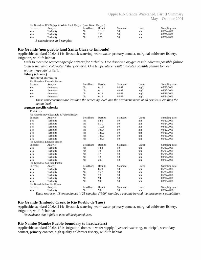
Rio Grande at USGS gage in White Rock Canyon (near Water Canyon) Exceeds: Analyte: LessThan: Result: Standard: Units: Sampling date: Yes Turbidity No 110.9 50 ntu 05/22/2001 Yes Turbidity No 166 50 ntu 08/21/2001 Yes Turbidity No 225 50 ntu 08/22/2001
3 exceedances in 6 samples. Rio Grande (non pueblo land Santa Clara to Embudo) Applicable standard 20.6.4.114: livestock watering, warmwater, primary contact, marginal coldwater fishery, irrigation, wildlife habitat
Fails to meet the segment-specific criteria for turbidity. One dissolved oxygen result indicates possible failure to meet marginal coldwater fishery criteria. One temperature result indicates possible failure to meet segment-specific criteria.
fishery (chronic) Dissolved aluminum Rio Grande at Embudo Station Exceeds: Analyte: LessThan: Result: Standard: Units: Sampling date: Yes aluminum No 0.12 0.087 mg/L 05/22/2001 Yes aluminum No 0.11 0.087 mg/L 05/23/2001 Yes aluminum No 0.12 0.087 mg/L 05/23/2001 Yes aluminum No 0.12 0.087 mg/L 05/24/2001
These concentrations are less than the screening level, and the arithmetic mean of all results is less than the action level.
segment specific criteria Turbidity Rio Grande above Espanola at Valdez Bridge Exceeds: Analyte: LessThan: Result: Standard: Units: Sampling date: Yes Turbidity No 54.6 50 ntu 05/22/2001 Yes Turbidity No 51.1 50 ntu 05/24/2001 Yes Turbidity No 119.8 50 ntu 08/21/2001 Yes Turbidity No 133.4 50 ntu 08/22/2001 Yes Turbidity No 146.2 50 ntu 09/25/2001 Yes Turbidity No 138.9 50 ntu 09/26/2001 Yes Turbidity No 133.5 50 ntu 09/27/2001 Rio Grande at Embudo Station Exceeds: Analyte: LessThan: Result: Standard: Units: Sampling date: Yes Turbidity No 73.2 50 ntu 05/22/2001 Yes Turbidity No 72 50 ntu 05/23/2001 Yes Turbidity No 77 50 ntu 05/24/2001 Yes Turbidity No 72 50 ntu 08/14/2001 Yes Turbidity No 295 50 ntu 08/15/2001 Rio Grande at San Juan Pueblo Exceeds: Analyte: LessThan: Result: Standard: Units: Sampling date: Yes Turbidity No 86.8 50 ntu 05/22/2001 Yes Turbidity No 75.7 50 ntu 05/23/2001 Yes Turbidity No 78 50 ntu 05/24/2001 Yes Turbidity No 94 50 ntu 08/14/2001 Yes Turbidity No 999 50 ntu 08/15/2001 Rio Grande below Rio Chama Exceeds: Analyte: LessThan: Result: Standard: Units: Sampling date: Yes Turbidity No 999 50 ntu 08/14/2001
These represent 18 exceedances in 25 samples. ("999" signifies a reading beyond the instrument's capability). Rio Grande (Embudo Creek to Rio Pueblo de Taos) Applicable standard 20.6.4.114: livestock watering, warmwater, primary contact, marginal coldwater fishery, irrigation, wildlife habitat No evidence that it fails to meet all designated uses. Rio Nambe (Nambe Pueblo boundary to headwaters) Applicable standard 20.6.4.121: irrigation, domestic water supply, livestock watering, municipal, secondary contact, primary contact, high quality coldwater fishery, wildlife habitat

Upper Rio Grande Watershed, Part II Summary May – October 2001
No evidence that it fails to meet all designated uses. This stream was sampled only three times for general chemistry and five times for nutrients (spring and fall only).
Rio Pueblo (Picuris Pueblo boundary to headwaters) Applicable standard 20.6.4.123: fish culture, wildlife habitat, livestock watering, high quality coldwater fishery, irrigation, domestic water supply, secondary contact
One turbidity result indicates possible failure to meet segment-specific criteria. This sampling did not include metals.
segment specific criteria Turbidity Rio Pueblo at Hwy 75 below Penasco Exceeds: Analyte: LessThan: Result: Standard: Units: Sampling date: Yes Turbidity No 28 25 ntu 08/15/2001
1 exceedance in 1 sample. This sampling did not include metals. Rio Quemado (Santa Cruz River to headwaters) Applicable standard 20.6.4.121: wildlife habitat, irrigation, livestock watering, high quality coldwater fishery, municipal, domestic water supply, secondary contact, primary contact
Fails to meet the segment-specific criteria for specific conductance and turbidity. This stream was sampled only three times.
segment specific criteria Conductivity Rio Quemado near Chimayo Exceeds: Analyte: LessThan: Result: Standard: Units: Sampling date: Yes Specific conductance No 334 300 umhos 10/03/2001
1 exceedance in 3 samples. Turbidity Rio Quemado near Chimayo Exceeds: Analyte: LessThan: Result: Standard: Units: Sampling date: Yes Turbidity No 20.3 10 ntu 05/22/2001 Yes Turbidity No 104 10 ntu 08/14/2001
2 exceedances in 3 samples. Rio Santa Barbara (Picuris Pueblo boundary to USFS boundary) Applicable standard 20.6.4.123: livestock watering, secondary contact, irrigation, wildlife habitat, fish culture, high quality coldwater fishery, domestic water supply
Fails to meet the segment-specific criteria for turbidity. This sampling did not include metals. segment specific criteria Turbidity Rio Santa Barbara at mouth Exceeds: Analyte: LessThan: Result: Standard: Units: Sampling date: Yes Turbidity No 36 25 ntu 08/14/2001 Yes Turbidity No 37 25 ntu 08/15/2001
2 exceedances in 8 samples. This sampling did not include metals. Rio Santa Barbara (USFS boundary to confluence of East and West forks) Applicable standard 20.6.4.123: livestock watering, high quality coldwater fishery, wildlife habitat, domestic water supply, secondary contact, fish culture, irrigation
No evidence that it fails to meet all designated uses. This sampling did not include metals. Rito de los Frijoles (Rio Grande to headwaters) Applicable standard 20.6.4.121: wildlife habitat, high quality coldwater fishery, irrigation, domestic water supply, municipal, primary contact, livestock watering, secondary contact
Fails to meet the segment-specific criteria for fecal coliforms (single sample), turbidity, and temperature (the temperature exceedance is based on thermograph data). This sampling did not include metals. The bacteria

Upper Rio Grande Watershed, Part II Summary May – October 2001
were sampled only three times. segment specific criteria Fecal coliforms, single sample Rito de los Frijoles above Upper Falls Exceeds: Analyte: LessThan: Result: Standard: Units: Sampling date: Yes fecals No 360 200 /100 mL 09/18/2001 Yes fecals No 300 200 /100 mL 10/17/2001
2 exceedances in 3 samples. Turbidity RITO CANON DE LOS FRIJOLES BELOW CAVE Exceeds: Analyte: LessThan: Result: Standard: Units: Sampling date: Yes Turbidity No 11.1 10 ntu 05/23/2001 Yes Turbidity No 12.7 10 ntu 05/24/2001 Yes Turbidity No 10.7 10 ntu 09/25/2001 Rito de los Frijoles above Upper Falls Exceeds: Analyte: LessThan: Result: Standard: Units: Sampling date: Yes Turbidity No 10.8 10 ntu 05/23/2001 Yes Turbidity No 13.5 10 ntu 08/21/2001
These represent 5 exceedances in 16 samples. San Cristobal Creek (Galisteo Creek to headwaters) Applicable standard unclassified: wildlife habitat, livestock watering
No evidence that it fails to meet all designated uses. This sample station was dry during some sampling visits. Santa Cruz River (Santa Cruz Reservoir to Rio Medio) Applicable standard 20.6.4.114: warmwater, livestock watering, marginal coldwater fishery, irrigation, primary contact, wildlife habitat
Fails to meet the chronic fishery criteria for aluminum. This stream was sampled only three times. fishery (chronic) Dissolved aluminum Santa Cruz River in Chimayo Exceeds: Analyte: LessThan: Result: Standard: Units: Sampling date: Yes aluminum No 0.2 0.087 mg/L 05/22/2001
This concentration exceeds the screening level, and the arithmetic mean of all 3 results (0.087 mg/L) meets the action level.
Tesuque Creek (Little Tesuque Creek to confluence of forks) Applicable standard 20.6.4.121: irrigation, secondary contact, municipal, wildlife habitat, primary contact, domestic water supply, high quality coldwater fishery, livestock watering
Fails to meet the segment-specific criteria for specific conductance and turbidity. This sampling did not include metals.
segment specific criteria Conductivity Tesuque Creek Across From Tesuque Post office Exceeds: Analyte: LessThan: Result: Standard: Units: Sampling date: Yes Specific conductance No 394 300 umhos 08/21/2001 Yes Specific conductance No 323 300 umhos 08/22/2001 Yes Specific conductance No 397 300 umhos 10/02/2001 Yes Specific conductance No 407 300 umhos 10/03/2001 Yes Specific conductance No 418 300 umhos 10/04/2001
5 exceedances in 8 samples. Turbidity Tesuque Creek Across From Tesuque Post office Exceeds: Analyte: LessThan: Result: Standard: Units: Sampling date: Yes Turbidity No 20.3 10 ntu 05/22/2001 Yes Turbidity No 16.4 10 ntu 05/23/2001 Yes Turbidity No 12.5 10 ntu 05/24/2001
3 exceedances in 8 samples.

Upper Rio Grande Watershed, Part II Summary May – October 2001
Tesuque Creek near Bishops Lodge Exceeds: Analyte: LessThan: Result: Standard: Units: Sampling date: Yes Turbidity No 15.4 10 ntu 05/22/2001 Yes Turbidity No 16.1 10 ntu 05/23/2001
2 exceedances in 8 samples. Tesuque Creek (North Fork) Applicable standard 20.6.4.121: secondary contact, wildlife habitat, primary contact, irrigation, domestic water supply, livestock watering, high quality coldwater fishery, municipal
No evidence that it fails to meet all designated uses. This sampling did not include metals. Tesuque Creek (South Fork) Applicable standard 20.6.4.121: domestic water supply, secondary contact, primary contact, wildlife habitat, high quality coldwater fishery, livestock watering, irrigation, municipal
No evidence that it fails to meet all designated uses. This sampling did not include metals. Trampas Creek (Rio Embudo to headwaters) Applicable standard 20.6.4.123: secondary contact, livestock watering, domestic water supply, fish culture, high quality coldwater fishery, irrigation, wildlife habitat
No evidence that it fails to meet all designated uses. This stream was sampled only three times.
7.0 CONCLUSIONS
The most common water quality exceedences and/or impairments identified as part of this study of the upper Rio Grande watershed between Embudo Creek and the Angostura Diversion were for turbidity. Aluminum was exceeded in the portions of the mainstem of the Rio Grande sampled as part of this study; however, the exceedences were not significant enough to classify the waterbody as impaired due to aluminum. The Rio Grande is impaired due to turbidity from Cochiti Reservoir to Embudo Station and biologically impaired from Santa Clara to Embudo Creek. Galisteo Creek, in the southern portion of the study area is impaired due to temperature and conductivity; however, the creek may be misclassified as a high quality coldwater fishery due to the fact that some portions of the creek go dry at times. Turbidity and mercury exceedences were also observed in these tributaries; however, they were not significant enough to be considered impaired due to these parameters. In the Los Alamos area, Pueblo Canyon, Mortandad Canyon, and Pajarito Canyon were all considered impaired due to gross alpha and selenium, and Pajarito Canyon was also impaired due to mercury. The selenium levels may be elevated due to the effects of the Cerro Grande fire. The Rito de los Frijoles was the most impaired waterbody in this portion of the study area and is impaired due to temperature, dichlorodiphenyltrichloroethane (DDT), fecal coliform and turbidity. Finally, Capulin Creek is biologically impaired and impaired due to stream bottom deposits. As you move up the watershed, the Pojoaque River is impaired due to stream bottom deposits and also had minor exceedences of aluminum, dissolved oxygen, temperature, and turbidity. In the Tesuque tributaries, water quality impairments exist for aluminum, conductivity, and turbidity. In the Chimayo area the only water quality impairment identified was for turbidity on the Rio Quemado, although there were also minor exceedences of aluminum, conductivity, and turbidity in some of these tributaries.

Upper Rio Grande Watershed, Part II Summary May – October 2001
In the upper portion of the study area water quality is biologically impaired and impaired due to turbidity on portions of the Rio Pueblo, Rio Santa Barbara, and Embudo Creek. Embudo Creek is also impaired due to stream bottom deposits. Minor exceedences were also observed in these tributaries for aluminum, conductivity, and turbidity.
8.0 REFERENCES
Barbour, M. T., J. Gerritsen, B. D. Snyder, and J. B. Stribling. 1999. Rapid Bioassessment Protocols for
Use in Streams and Wadeable Rivers: Periphyton, Benthic Macroinvertebrates and Fish, Second Edition. EPA 841-B-99-002. U. S. Environmental Protection Agency; Office of Water; Washington, D. C.
New Mexico Environment Department. 2001. Quality Assurance Project Plan for Water Quality
Management Programs, 2001. NMED/SWQB EPA QAPP QTRCK Number Q-01-122. New Mexico Environment Department Surface Water Quality Bureau (NMED/SWQB). 2004a.
Assessment Protocol. Santa Fe, NM. New Mexico Environment Department Surface Water Quality Bureau (NMED/SWQB). 2004b.
Integrated Clean Water Act §303(d)/ §305(b) Report. Santa Fe, NM. New Mexico Water Quality Control Commission (WQCC). 2002. Standards for Interstate/Intrastate
Surface Waters. NM Administrative Code 20.6.4, October 11, 2002, ed. The Clean Water Act (CWA), 33 USC 1251 et seq.
![Embudo de Marsh, Reología, Suspensión cementicia ...EMBUDO DE MARSH El embudo de Marsh (ver Fig. 1) fue inventado a principios de la década de 1930 [2]. Se trata de un instrumento](https://img.pdfslide.net/doc/110x75/613708b00ad5d20676485bb7/embudo-de-marsh-reologa-suspensin-cementicia-embudo-de-marsh-el-embudo.jpg)