Embed Size (px)
Citation preview
Bexar County CourthouseMonitoringRestoration
San Antonio Bexar County Texasby
Antonia L Figueroa and Jason B Perez
Principal InvestigatorPaul Shawn Marceaux
Texas Antiquities Permit No 7065
Prepared for Joeris General Contractors823 Arion Parkway
San Antonio Texas 78216Preserving Cultural Resources
copy 2015
Prepared by Center for Archaeological ResearchThe University of Texas at San Antonio
One UTSA CircleSan Antonio Texas 78249-1644Archaeological Report No 447
Bexar County Courthouse
MonitoringRestoration San Antonio
Bexar County Texas by
Antonia L Figueroa and Jason B Perez
Texas Antiquities Committee Permit No 7065
Principal Investigator
Paul Shawn Marceaux
Prepared for Prepared by Joeris General Contractors Center for Archaeological Research
823 Arion Parkway The University of Texas at San Antonio San Antonio Texas 78216 One UTSA Circle
San Antonio Texas 78249
copy 2015 Archaeological Report No 447
iii
Bexar County Courthouse MonitoringRestoration Abstract
Abstract
In October 2014 and February 2015 the Center for Archaeological Research (CAR) of The University of Texas at San Antonio (UTSA) conducted archaeological monitoring of the construction associated with Main Street next to the Bexar County Courthouse Bexar County Texas The archaeological investigations and construction monitoring were conducted under Texas Antiquities Committee Permit No 7065 with Dr Paul Shawn Marceaux serving as the Principal Investigator and Antonia Figueroa as the Project Archaeologist
The goal of archaeological monitoring was to identify any historical properties or features that might be present in the project area To achieve this goal a CAR staff member monitored construction crews while they excavated the old road and soil beneath it In Section 1 the southern portion of Main Street no features were uncovered and CAR staff observed only a few artifacts In Section 2 the northern portion 14 features were documented including one brick lined privy These features were left intact and were incorporated into site 41BX1753 a State Antiquities Landmark (SAL) that was previously recorded by Post Buckley Schuh and Jernigan Inc (Hanson 2009) CAR recommends further investigations if Main Street is disturbed in the future as intact deposits are present All collected artifacts and project associated documentation are permanently curated at the CAR facility
v
Bexar County Courthouse MonitoringRestoration Table of Contents
Table of Contents
Abstract iii Table of Contents v List of Figures vi List of Tablesvii Acknowledgementsviii
Introduction 1Chapter 1The Project Area and APE 1
Chapter 2 History of the Project Area and Previous Archaeological Investigations 3 Archival Research of the Project Area 3 Previous Archaeology 4
Chapter 3 Archaeological Field and Laboratory Methods 7 Field Methods 7 Archaeological Laboratory Methods 7
Chapter 4 Results of the Archaeological Investigations 9 Archaeological Monitoring of Section 1 9 Archaeological Monitoring of the Section 2 10
Feature 1 10 Feature 2 14 Feature 3 14 Feature 4 14 Feature 5 14 Features 6 and 7 16 Feature 8 16 Features 9 and 10 16 Feature 11 18 Features 12 and 13 18 Feature 14 19
Chapter 5 Summary and Recommendations 21 References Cited 23
vi
List of Figures Bexar County Courthouse MonitoringRestoration
List of Figures
Figure 1-1 Project area (yellow) on USGS San Antonio East 75-minute quadrangle map 1 Figure 1-2 Sections 1 and 2 on the APE (outlined in yellow) 2 Figure 2-1 Early maps depicting the project area (left Menchaca 1764 and right Urrutia 1767 north is left hand of page) 3 Figure 2-2 Sanborn Insurance maps depicting the project area in 1888 (left) and 1896 (right) 4 Figure 2-3 1904 Sanborn Fire Insurance Map depicting the project area (with project area outlined in black) 5 Figure 4-1 Southern portion of Section 1 (facing north) 9 Figure 4-2 Removal of asphalt of Section 2 (facing east) 10 Figure 4-3 Illustration of Section 2 and location of features 11 Figure 4-4 3-D imaging of Feature 1 12 Figure 4-5 Artifacts associated with Feature 1 13 Figure 4-6 Feature 2 (facing west) 14 Figure 4-7 Feature 3 15 Figure 4-8 Feature 4 15 Figure 4-9 Feature 5 a brick lined privy 15 Figure 4-10 Features 6 and 7 16 Figure 4-11 Feature 8 (facing south) 17 Figure 4-12 Features 9 and 10 (facing west) 17 Figure 4-13 Feature 11 (facing south) 18 Figure 4-14 Features 12 and 13 (facing north) 18 Figure 4-15 Feature 14 (facing south) 19
vii
Bexar County Courthouse MonitoringRestoration List of Tables
List of Tables
Table 4-1 Features from Section 2 12 Table 4-2 Cultural Material Recovered from Feature 1 13 Table 4-3 Cultural Material Recovered from Feature 2 14
viii
Acknowledgements Bexar County Courthouse MonitoringRestoration
Acknowledgements
The completion of this project could not have occurred without the support of several individuals The author would like to thank the field crew from the CAR Leonard Kemp and Raymond Mauldin helped to excavate the foundations on a warm Sunday morning under the watchful eyes of the local Bexar County Sheriffrsquos Department Leonard Kemp completed the figures for the report and was responsible for the 3-D imagery of the foundation Laura Carbajal downloaded the GPS data Kelly Harris edited the report A final thank you to Melissa Eiring for curating the artifacts
Special thanks to Salvador Garcia Jr with Alamo Architects and Alexandrea Trevino Assistant Project Manager with Joeris General Contractors The excavation crew from DampD Contractors Inc were easy to work with and included Damian Augustine Evelio Cedeno TJ Jackson Chris Koerber Gene Mireles Jorge Rios Mark Steiger Esteban Villanueva and Steve Villanueva Thanks go to Kay Hindes with the City of San Antonio Office of Historic Preservation Dr Paul Shawn Marceaux served as the Principal Investigator and provided comments on the draft report
1
Bexar County Courthouse MonitoringRestoration Chapter One Introduction
Chapter 1 Introduction
The Center for Archaeological Research (CAR) of The University of Texas at San Antonio (UTSA) was contracted by Joeris General Contractors to conduct archaeological monitoring of the construction on Main Street next to the Bexar County Courthouse San Antonio Bexar County Texas Monitoring by CAR staff took place October 25-29 2014 and February 5-10 2015 This project is a continuation of the Gondeck demolition and restoration of the Bexar County Courthouse Figure 1-1 shows the project area on the USGS San Antonio East 75-minute quadrangle map
The Bexar County Courthouse is listed as a State Antiquities Landmark (SAL) SALs are designated by the Texas Historical Commission (THC) and receive legal protection under the Antiquities Code of Texas Although it is associated with the Courthouse project this work was officially initiated
as part of an agreement between Bexar County and the City of San Antonio regarding streets Kay Hindes with the City of San Antonio Office of Historic Preservation included a stipulation in the agreement that any street work would require an archeology permit from the state This archaeological investigation was performed under THC Permit No 7065 with Antonia L Figueroa serving as the Project Archaeologist and Dr Paul Shawn Marceaux serving as the Principal Investigator The fieldwork was conducted by CAR staff member Jason B Perez
The Project Area and APE
The project area is located in downtown San Antonio Bexar County Texas (Figure 1-2) The Area of Potential Effect (APE) consists of the portion of Main Street that spans roughly 180 meters (m) from Main Plaza to Nueva Street
Figure 1-1 Project area (yellow) on USGS San Antonio East 75-minute quadrangle map
Chapter One Introduction Bexar County Courthouse MonitoringRestoration
2
immediately adjacent to the Bexar County Courthouse Impacts included the removal of asphalt and the base of Main Street The street was resurfaced with concrete designed to mimic the stones of Main Plaza The newly resurfaced street will accommodate vehicular traffic associated with the Bexar
County Courthouse and Justice Center The APE was divided into two sections Section 1 began at West Nueva Street and extended north for 100 m along Main Street The second section extended about 50 m in length southward from Dolorosa Street to the beginning of Section 1
Figure 1-2 Sections 1 and 2 on the APE (outlined in yellow)
3
Bexar County Courthouse MonitoringRestoration Chapter Two History of the Project Area and Previous Archaeological Investigations
Chapter 2 History of the Project Area and Previous Archaeological
Investigations
This chapter begins with a short historical background for the Main Street corridor based on early accounts deed history and Sanborn Fire Insurance Maps A detailed history of the block and property transactions can also be found in Hanson (2010) The second part of this chapter provides a brief summary of previously recorded sites in the area Site 41BX1753 in the current project area was previously identified and tested by Post Buckley Shuh and Jernigan Inc (PBSampJ Hanson 2009) and as explained in Chapter 5 the features found during the current project were incorporated into site 41BX1753 In 2008 41BX1753 was designated as an SAL
Archival Research of the Project Area
In 1718 Don Martiacuten de Alarcoacuten the governor of Coahuila and Texas led an entrada of six dozen people 548 horses and additional livestock in Spainrsquos earliest attempt to settle the area that would become San Antonio (Chipman 1992) Within days of his arrival Mission San Antonio de Valero San Antonio de Beacutexar Presidio and the Villa de Beacutexar were established on the west bank of San Pedro Creek and adjacent to San Pedro Springs (Chipman 2010) By 1721 the structures were moved further south to their current locations between the San Antonio River and San Pedro Creek
To develop settlement in the San Antonio area King Philip V of Spain offered free passage to New Spain free land and the status of a noble (hidalgo) to Canary Islanders (Cox 199710) By March of 1731 a group of fifteen families arrived and settled in the area of the Military Plaza and Main Plaza (Handbook of Texas Online 2010)
Earliest depictions of Main Plaza indicate structures existed in Section 2 (northern portion) of the project area in the 1760s but no structures were present in Section 1 For example maps of San Antonio de Beacutexar drawn by Luis Antonio Menchaca (1764) and Joseacute de Urrutia (1767) both depict a structure in the northern portion of the project area (Figure 2-1) The project area was approximated on both maps due to the lack of scale on the original copies
Sanborn maps of the project area dating to 1888 and 1896 indicate the St Leonardrsquos Hotel was in Section 2 and Section 1 was a labeled as a private alley on both maps (Figure 2-2) According to a 1910 article in the San Antonio Light the St Leonard Hotel was ldquoone of the leading hotels of the city and many prominent persons including Mexican and American generals of the highest rank stopped at the hostelryrdquo (San Antonio Light 1910) Features found during monitoring are thought to be from this period Further discussion is presented in Chapter 4
Figure 2-1 Early maps depicting the project area (left Menchaca 1764 and right Urrutia 1767 north is left hand of page)
4
Chapter Two History of the Project Area and Previous Archaeological Investigations Bexar County Courthouse MonitoringRestoration
Figure 2-2 Sanborn Insurance maps depicting the project area in 1888 (left) and 1896 (right)
According to the 1904 Sanborn map of the project area the structure in Section 2 is a carriage house and Elliotrsquos Flat (Figure 2-3) In December of 1924 George W Burkitt Jr conveyed the tract to Bexar County for the purpose of continuing Main Street from the Main Plaza through the subject tract to Nueva Street (Bexar County Deed Records 80250)
The portion of Main Street paved over the subject tract in the late 1920s remained intact until the spring of 2007 when Jerdon Construction conducted work on Main Plaza and archaeological site 41BX1753 was documented (Hanson 2010) The archaeological features found in association with the project appear to be related to St Leonardrsquos Hotel Furthermore the features were incorporated as part of the previously recorded site 41BX1753 (see Chapter 4)
Previous Archaeology
There are several archaeological sites located in downtown San Antonio Texas including in the vicinity of the project area As previously noted the Bexar County Courthouse is listed as a SAL To date no archaeological sites have been recorded within the APE For the purposes of this report only those sites within 60 m or less of the APE will be reviewed Archaeological sites that will be discussed in this section are 41BX7 41BX334 41BX335 41BX336 41BX337 41BX647 41BX1775 and 41BX1753 Major archaeological projects in the area consist of those associated with the Bexar
County Justice Center investigations (Figueroa 2011 Fox et al 1989) the San Pedro Acequia (Cox 1986 1995 2005 Frkuska 1981) and San Fernando Cathedral investigations (Fox et al 1977)
Archaelogical investigations associated with San Fernando Cathedral (41BX7) occurred in the late 1970s (Fox et al 1977) San Fernando Cathedral is located northeast of the APE Archaeologists from the Office of the State Archaeologist conducted excavations associated with the installation of air conditioning ducts in the floor of the San Fernando Cathedral Archaeological testing recovered a variety of artifacts as well as animal bone which appeared to date from the Spanish Colonial period through the early 1870s (Fox et al 1977) Subsequent monitoring work at the cathedral also occurred in the early 2000s by CAR (Cox nd)
The area to the west of the APE was first investigated in 1978 by CAR (Fox et al 1989) and during this time three small residences (41BX334 41BX335 and 41BX336) and the San Pedro Acequia (41BX337) were documented Furthermore sites 41BX334 and 41BX335 are listed as SALs Site 41BX334 was the residence of Dr Charles Campbell author of the book Bats Mosquitoes and Dollars published in 1925 During the 1978 investigations the kitchen wall was uncovered by a backhoe trench Site 41BX335 consisted of architectural and artifacts dating from 1850 to 1900 Two structures comprised site 41BX336 One was made of adobe
5
Bexar County Courthouse MonitoringRestoration Chapter Two History of the Project Area and Previous Archaeological Investigations
Figure 2-3 1904 Sanborn Fire Insurance Map depicting the project area (with project area outlined in black)
6
Chapter Two History of the Project Area and Previous Archaeological Investigations Bexar County Courthouse MonitoringRestoration
and the other was made of limestone dating from the mid-nineteenth century to the early twentieth century The San Pedro Acequia (41BX337) was recorded in the northern portion of the project area in the 1978 investigations Fox et al (1989) reported the acequia was lined with cut limestone and filled with nineteenth- and early twentieth-century artifacts
Site 41BX647 (Salinas-Barrera house) was recorded in the late 1970s (Fox et al 1989 THC 2014) also during investigations related to the Bexar County Courthouse In the late eighteenth and early nineteenth century the property was owned by Francisco Manuel Salinas During testing the east wall of the house was encountered along with Goliad ware and eighteenth-century tin-glazed ceramics
Between 2008 and 2010 the CAR conducted archaeological investigations (backhoe trenching shovel tests and one test unit) and monitoring for the Bexar County Justice Center Expansion Project (Figueroa 2011) During archaeological investigations the San Pedro Acequia (41BX337) and 41BX334 were revisited Furthermore a new site 41BX1775 was documented The San Pedro Acequia was documented in the excavation of a backhoe trench conducted during the CARrsquos investigations The majority of the materials recovered from the acequia fill ranged in date from 1884 to the early twentieth century Retrieved materials included white earthenwares glass bottles metal bone and other materials (see Figueroa 2011Table 4-2) The earliest dated item recovered from the acequia was an 1884 nickel There was some disturbance to the acequia in the form of two concrete walls
Two backhoe trenches were excavated to expose the kitchen structure associated with 41BX334 However only two pieces of limestone along with ceramics bone and glass were encountered It was concluded by the CAR that the kitchen structure associated with 41BX334 was possibly demolished during previous construction efforts (Figueroa 201120)
Site 41BX1775 was composed of eight architectural features represented by brick and limestone walls The features are isolated from one another and do not appear to be associated The limestone walls (n=4) and plaster floor (n=1) might date to 1885 while the brick walls (n=3) are likely from the early to mid-twentieth century Artifacts retrieved during shovel testing and backhoe trenching date from the late nineteenth to early twentieth century
Subsequent to these investigations CAR recommended archaeological monitoring of construction activities including the building footprint excavations No additional sites were documented during this phase of the project Further work was not recommended on site 41BX1775 or the San Pedro Acequia (41BX337)
In 2007 State Antiquities Landmark 41BX1753 was recorded by PBSampJ (Hanson 2009 THC 2014) This site is located less than one meter east of South Main Street 70 m south of Market Street and the South Main Street Intersection and less than two meters west of the Bexar County Courthouse (THC 2014) The site is described as five buried historic features encountered in a storm drain installation off South Main Street in the County Courthouse Parking area The five features encountered during investigations were described as two privies (Features 1 and 3) and three middens (Features 2 4 and 5) Feature 1 is described as a privy with late nineteenth-century material Feature 2 was a midden with late Spanish Colonial and Mexican Period artifacts Feature 3 was a mid-nineteenth-century privy Feature 4 was a late nineteenth-century to early twentieth-century midden pit and Feature 5 was described as a late nineteenth-century and early twentieth-century midden (THC 2014) The extent of the site was limited to the storm drain installation trench PBSampJ recommended Features 2 and 3 for Phase III data recovery excavations and that impacts to the remaining site be avoided (THC 2014)
7
Bexar County Courthouse MonitoringRestoration Chapter Three Archaeological Field and Laboratory Methods
Chapter 3 Archaeological Field and Laboratory Methods
Field Methods
As mentioned impacts to the APE included the removal of the asphalt and base of what was Main Street
Several archaeological sites have been recorded in close proximity to the APE Since 41BX1753 was the nearest site to the APE there was potential for encountering archaeological resources During the removal of the asphalt and base of Main Street CAR staff monitored the activities When cultural remains andor features were encountered during the course of the monitoring CAR archaeologists halted the excavations in the vicinity until the deposit and or feature were documented The documentation consisted of digital photography sketch drawings and GPS recordation of location information Only temporally diagnostic artifacts were collected with appropriate provenience information and returned to the CAR laboratory for processing
Archaeological Laboratory Methods
All cultural materials and records obtained andor generated during the project were prepared in accordance with federal regulation 36 CFR part 79 and THC requirements for State Heldshyin-Trust collections Artifacts processed in the CAR laboratory were washed air-dried and stored in 4-mm zip-locking archival-quality bags Organic materials and materials needing extra support were double-bagged Acid-free labels were placed in all artifact bags Each label contained provenience information and a corresponding lot number written in archival ink with pencil or by laser printed Ceramics were labeled with permanent ink over a clear coat of acrylic and covered by another acrylic coat Artifacts were separated by class and stored in acid-free boxes Digital photographs were printed on acid-free paper labeled with archivally appropriate materials and placed in archival-quality sleeves All field forms were completed with pencil Upon completion of the project all collected materials will be housed at the CAR
9
Bexar County Courthouse MonitoringRestoration Chapter Four Results of Archaeological Investigations
Chapter 4 Results of the Archaeological Investigations
This chapter presents the results of the current archaeological investigations that occurred in association with the monitoring of the Bexar County Courthouse Monitoring took place in October 2014 (Section 1) and February 2015 (Section 2) Fourteen features were found in Section 2 The features found during archaeological monitoring are part of site 41BX1753 originally documented by PBSampJ in 2007 (Hanson 2009)
Archaeological Monitoring of Section 1
Monitoring of Section 1 was conducted from October 25-29 2014 The southern section of the APE consisted of an amount of roadway 1158 m wide 7376 m long and 5080 cm deep but an additional 1524 cm was removed due to the lack of moisture in the soil The average depth of the asphalt measured from 6-15 cm Utilities found included old gas lines sewer lines
and copper electrical lines that provided power to the entrance exit arms situated at the entrance to the street Throughout the area cement pads were used to protect underground utilities These cement pads were initially left in place however they were eventually removed by the DampD crew During this time no features were found within the area Artifacts documented but not collected included one horseshoe (21 cm below the asphalt) and a few ceramics including edgeware Figure 4-1 shows the southern boundaries of Section 1
The first phase of the process consisted of an excavator removing soil using a bucket with a maximum capacity of 120 m3 After the initial removal of soil a wheel loader was used to move the mounds of soil and place them in semi-trucks During the next phase a motor grader was used to ensure the depth of the soil was consistent The final phase involved a road roller which compacted the soil
Figure 4-1 Southern portion of Section 1 (facing north)
10
Chapter Four Results of the Archaeological Investigations Bexar County Courthouse MonitoringRestoration
Archaeological Monitoring of the Section 2
In February 2015 monitoring was conducted for five days on Section 2 and an additional day was needed to excavate around the foundations and photograph and map them Section 2 of the APE consisted of an amount of roadway 1113 m wide and 7010 m long that was removed and the crew excavated the section to a depth of 5080 cm No soil beyond the 5080 cm was removed unlike in the southern section of the APE Within the middle section of the APE a tunnel used by the Sheriffrsquos Department to transport prisoners ran from east to west below the street Only the top layer of road base was removed from this section The thickness of the asphalt in this area was similar in depth to the southern section except for the area covering the underground tunnel which was approximately 1524-cm thick This section of the roadway also included cement pads which were temporarily left in place until the DampD crew removed them During the monitoring of this section of the APE 14 features were found
The first phase of the process consisted of an excavator removing soil using a bucket with a maximum capacity of 120 m3 (Figure 4-2) After the initial removal of soil a wheel loader
moved the mounds of soil and placed them in semi-trucks During the next phase a skid loader graded the soil down to a consistent depth The final phase of the process involved a road roller which compacted the soil While excavating above the underground tunnel a mini excavator was used to remove a small amount of road top Fourteen features were found in Section 2 (Figure 4-3 Table 4-1) and were included in previously recorded site 41BX1753 (SAL)
Feature 1
The feature was a foundation that consisted of small limestone rocks with a sandy mortar paste (Figure 4-4) The foundation had a variable thickness due to multiple portions being removed by previous excavations including the probable placement of the gas lines that went north to south across the entire roadway The western portion of the feature was covered in concrete and the eastern portion of the feature had a concrete pad that went across it in a north to south direction While excavating along the edges of Feature 1 artifacts were collected in the soil on both the northern and southern section of the foundation (Figure 4-5) These artifacts are listed in Table 4-2 and suggest a late nineteenth-century affiliation
Figure 4-2 Removal of asphalt of Section 2 (facing east)
11
Bexar County Courthouse MonitoringRestoration Chapter Four Results of Archaeological Investigations
Figure 4-3 Illustration of Section 2 and location of features
12
Chapter Four Results of the Archaeological Investigations Bexar County Courthouse MonitoringRestoration
Table 4-1 Features from Section 2
Feature Type Size (meters) 1 Limestone foundation 490 x 003 2 Limestone foundation 050 x 010 3 Charcoal stain 030 x 030 4 Charcoal stain 020 x 020 5 Privy 080 x 070 x 012 6 Limestone foundation 030 x 010 7 Concrete foundation 080 x 010 8 Limestone foundation 150 x 010 9 Cement 170 x 020 10 Cement 090 x 010 11 Limestone foundation 030 x 015 12 Limestone foundation 350 x 05 13 Limestone foundation 360 x 005 14 Brick pier 030 x 030
Figure 4-4 3-D imaging of Feature 1
13
Bexar County Courthouse MonitoringRestoration Chapter Four Results of Archaeological Investigations
Figure 4-5 Artifacts associated with Feature 1
Table 4-2 Cultural Material Recovered from Feature 1
Class Type Count Weight (g) Comments ContainerVessel Aqua 3 Bottle base ContainerVessel Clear 7 Bottleneck ContainerVessel Dark Olive Green 1 ContainerVessel Olive Green 3 Bottle base
European Earthenware Annularware 1 Mugcupbowl European Earthenware Edgeware 1 Rim European Earthenware Ironstone 1 Hotelware-platter European Earthenware Scalloped edgeware 1 Rimbase European Earthenware Transferware 1 Rimbase
European Porcelain Gilded 4 Rim base European Stoneware 1 Some kind of pipe incised triangle European Stoneware 1 Plateplatter base European Stoneware 1
Faunal Bone Mammal 2 222 Flat 1
Nails Wire 1 96 Other Glass Object Bottle stopper 1 Aqua Other Metal Objects Copper 3 3606
14
Chapter Four Results of the Archaeological Investigations Bexar County Courthouse MonitoringRestoration
Feature 2 Feature 4
Feature 2 consisted of a foundation segment (050-x-010 m) aligned in a north to south direction (Figure 4-6) Feature 2 was found at a depth of 4826 cm below the surface (cmbs) The foundation was made from limestone material similar to that of Feature 1 Feature 2 appears to be the remnants of a foundation as multiple segments of foundation going in the same direction and in the same alignment were found in the middle section of the APE Artifacts directly associated with Feature 2 consisted of glass (Table 4-3) with one diagnostic artifact a NuGrape soda bottle dating between 1915 and 1924 (Clinton M M McKenzie personal communication 2015) Feature 2 was reburied with soil and left in place
Feature 3
Feature 3 consisted of a charcoal stain 030-x-030 m in size and located 5080 cmbs (Figure 4-7) There were no artifacts associated with the stain and no excavation was performed Feature 3 was left in place
Figure 4-6 Feature 2 (facing west)
Feature 4 consisted of a charcoal stain 020-x-020 m in size and located 5080 cmbs (Figure 4-8) There were no artifacts associated with the stain and no excavation was performed Feature 4 was left in place
Feature 5
Feature 5 consisted of a privy that was lined with handmade bricks (Figure 4-9) The bricks were laid out in a U-shaped pattern with the base of the U going in a north to south direction The feature measured 080-x-070-x-012 m and was located 4826 cmbs The bricks were double stacked at least No further depth was excavated and the bricks were preserved in place CAR staff interpreted this feature to be a privy associated with the St Leonardrsquos Hotel Privies with similar characteristics were identified during the Alamodome project (Brown and DelaO 1997) No artifacts were directly associated with Feature 5
Table 4-3 Cultural Material Recovered from Feature 2
Class Type Count Comments ContainerVessel Soda bottle 1 NuGrape ContainerVessel Olive Green 1 Wine bottle ContainerVessel Aqua 1 Bottle rim ContainerVessel Milk 1
Other Glass Object Handle 1
15
Bexar County Courthouse MonitoringRestoration Chapter Four Results of Archaeological Investigations
Figure 4-7 Feature 3
Figure 4-8 Feature 4
Figure 4-9 Feature 5 a brick lined privy
16
Chapter Four Results of the Archaeological Investigations Bexar County Courthouse MonitoringRestoration
Features 6 and 7
Feature 6 consisted of a limestone foundation (030-x-010 m) and was aligned in a north to south direction (Figure 4-10) This feature was in line with the segment from Feature 2 Feature 6 was found at a depth of 4826 cmbs The foundation was made from the same material as Feature 1 No artifacts were directly associated with this feature Feature 6 was reburied with soil and left in place
Feature 7 consisted of a concrete foundation (080-x-010 m) with rebar protruding from it (see Figure 4-10) The rebar was apparently of an older style according to the construction workers Feature 7 was aligned in an east to west direction in close proximity to Feature 6 Feature 7 was 4064 cmbs but was skimmed down to approximately 5080 cmbs Artifacts associated with Feature 7 were metal including pieces of auto or machinery that were not collected
Feature 8 Feature 8 consisted of a foundation segment (150-x-010 m) and was aligned in a north to south direction (Figure 4-11) The feature was in line with the segment from Features 2 and 6 Feature 8 was found at a depth of 4826 cmbs The foundation was made from the same material as Feature 1 No artifacts were directly associated with this feature Feature 8 was reburied with soil and preserved in place
Features 9 and 10 Feature 9 (170-x-020 m) and Feature 10 (090-x-010 m) consisted of a cement and rebar foundation in the same style as Feature 7 The features ran parallel to each other in an east to west alignment and were perpendicular to Feature 8 Features 9 and 10 were approximately 40 cm apart from each other (Figure 4-12) Both features were above the desired level of the APE excavation and were skimmed down to 5080 cmbs No artifacts were associated with Feature 9 or Feature 10
Figure 4-10 Features 6 and 7
17
Bexar County Courthouse MonitoringRestoration Chapter Four Results of Archaeological Investigations
Figure 4-11 Feature 8 (facing south)
Figure 4-12 Features 9 and 10 (facing west)
18
Chapter Four Results of the Archaeological Investigations Bexar County Courthouse MonitoringRestoration
Feature 11 Feature 11 consisted of two large limestone blocks (Figure 4-13) Both blocks were approximately 15 cm across at their widest dimension The feature was found at a depth of 5080 cmbs No artifacts were directly associated with Feature 11 and it did not align with any of the other features Feature 11 was reburied with soil and left in place
Features 12 and 13
Features 12 and 13 consisted of two strips of probable foundation that were similar in appearance to the other limestone rock foundations identified on the project area (Figure 4-14) The foundation was made from limestone Features 12 and 13 were found at the surface of 5080 cm Both
Figure 4-13 Feature 11 (facing south)
Figure 4-14 Features 12 and 13 (facing north)
19
Bexar County Courthouse MonitoringRestoration Chapter Four Results of Archaeological Investigations
features were approximately 5 cm in width Feature 12 was 350 m in length Feature 13 was broken into two sections with the southern section measuring 2 m in length and the northern section 160 m in length Neither feature was in alignment with any of the previous features and both were at a lower depth than other features No artifacts were associated with Feature 12 or Feature 13 The features were left in place
Figure 4-15 Feature 14 (facing south)
Feature 14
Feature 14 consisted of a brick ldquopierrdquo corner (030-x-030 m) and was 4572 cmbs (Figure 4-15) The feature was not associated with any other feature or with any artifacts Feature 14 was reburied and left undisturbed
21
Bexar County Courthouse MonitoringRestoration Chapter Five Summary and Recommendations
Chapter 5 Summary and Recommendations
The CAR conducted monitoring along Main Street for Joeris General Contractors in October 2014 and February 2015 The project area is depicted on early maps dating to the late eighteenth century and on Sanborn Fire Insurance Maps from the late nineteenth and early twentieth century During mechanical digging of the project area 14 features were documented and left intact After examining the cultural material Sanborn maps and deed records it was established that the features found on the project area were associated
with the St Leonardrsquos Hotel It was concluded that these features would be included with previously recorded SAL 41BX1753 (Hanson 2009) therefore the site form will be updated to include the results of the current archaeological findings and to redefine site boundaries The 14 features were documented by CAR staff and not removed CAR recommends archaeological monitoring should be conducted if future work is performed on Main Street as evidence of subsurface deposits is present
23
Bexar County Courthouse MonitoringRestoration References Cited
References Cited
Bexar County Deed Records 1924 On file at Bexar County Courthouse San Antonio Texas Electronic documents httpgovpropertyinfocomTX-
BexarDefaultaspx accessed August 2015
Brown M and N DeLaO 1997 Beneath a Cresent Moon A Contextual and Architectural Analysis of Privies from the Alamodome Project Area In
Archaeology at the Alamodome Investigations of a San Antonio Neighborhood in Transition edited by AA Fox M Renner and RJ Hard pp 256-272 Archaeological Survey Report No 238 Center for Archaeological Research The University of Texas at San Antonio
Chipman DE 1992 Spanish Texas 1519-1821 University of Texas Press
2010 Alacron Martin de Handbook of Texas Online Texas State Historical Association Electronic document http wwwtshaonlineorghandbookonlinearticlesfal02 accessed August 26 2015
Cox IW nd Notes on file at the Center for Archaeological Research The University of Texas at San Antonio
1986 Excavations of Portions of the San Pedro Acequia (41BX337) and a Search for the Arocha Acequia San Antonio Texas Archaeological Survey Report No 161 Center for Archaeological Research The University of Texas at San Antonio
1995 Documentation of the San Pedro Acequia (41BX337) at Trevino Street San Antonio Texas Archaeological Survey Report No 230 Center for Archaeological Research The University of Texas at San Antonio
1997 The Growth of San Antonio In Archaeology at the Alamodome Investigations of a San Antonio Neighborhood in Transition Vol 1 Historical Architectural and Oral History Research edited by AA Fox M Renner and RJ Hard pp 8-39 Archaeological Survey Report No 236 Center for Archaeological Research The University of Texas at San Antonio
2005 The Spanish Acequias of San Antonio Maverick Publishing Company San Antonio
Figueroa AL 2011 Archaeological Investigations and Construction Monitoring at the Bexar County Justice Center Expansion Project
San Antonio Bexar County Texas Archaeological Report No 392 Center for Archaeological Research The University of Texas at San Antonio
Fox AA IW Cox L Highley and D Hefernik 1989 Archaeological and Historical Investigations at the Site of the New Bexar County Justice Center in Downtown San
Antonio Texas Archaeological Survey Report No 184 Center for Archaeological Research The University of Texas at San Antonio
Fox DE D Scurlock and JW Clark 1977 Archaeological Excavations at San Fernando Cathedral San Antonio Texas A Preliminary Report Office of the
State Archeologist Texas Historical Commission Austin
Frkuska AJ Jr 1981 Archaeological Investigations at the San Pedro Acequia San Antonio Texas Archaeological Survey Report No
103 Center for Archaeological Research The University of Texas at San Antonio
24
References Cited Bexar County Courthouse MonitoringRestoration
Handbook of Texas Online 2010 Canary Islanders Handbook of Texas Online Texas State Historical Association Electronic document httpwww
tshaonlineorghandbookonlinearticlespoc01) accessed August 31 2015
Hanson CJ 2009 Archaeological Investigations at the Bexar County Courthouse San Antonio Texas Document Number 090180
PBSampJ Austin
2010 The Archaeology of San Antoniorsquos Main Plaza Investigations at 41BX1753 Masterrsquos thesis The University of Texas at Austin University of Texas Libraries Digital Repository Electronic document httprepositorieslib utexaseduhandle2152ETD-UT-2010-12-2473 accessed August 2015
San Antonio Light 1910 First Buildings in Ancient San Antonio on Main Plaza 10 June
Texas Historical Commission (THC) 2014 Texas Archaeological Sites Atlas Texas Historical Commission Electronic document httpnuecesthcstatetxus
accessed October 21 2014
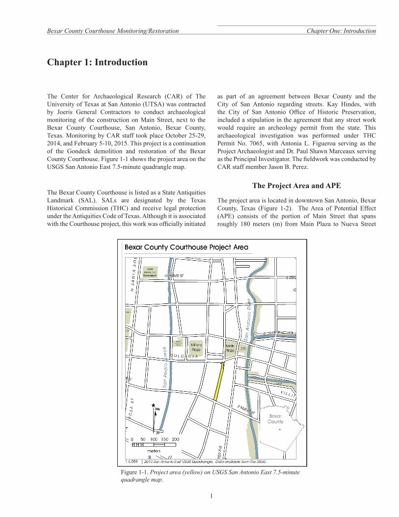
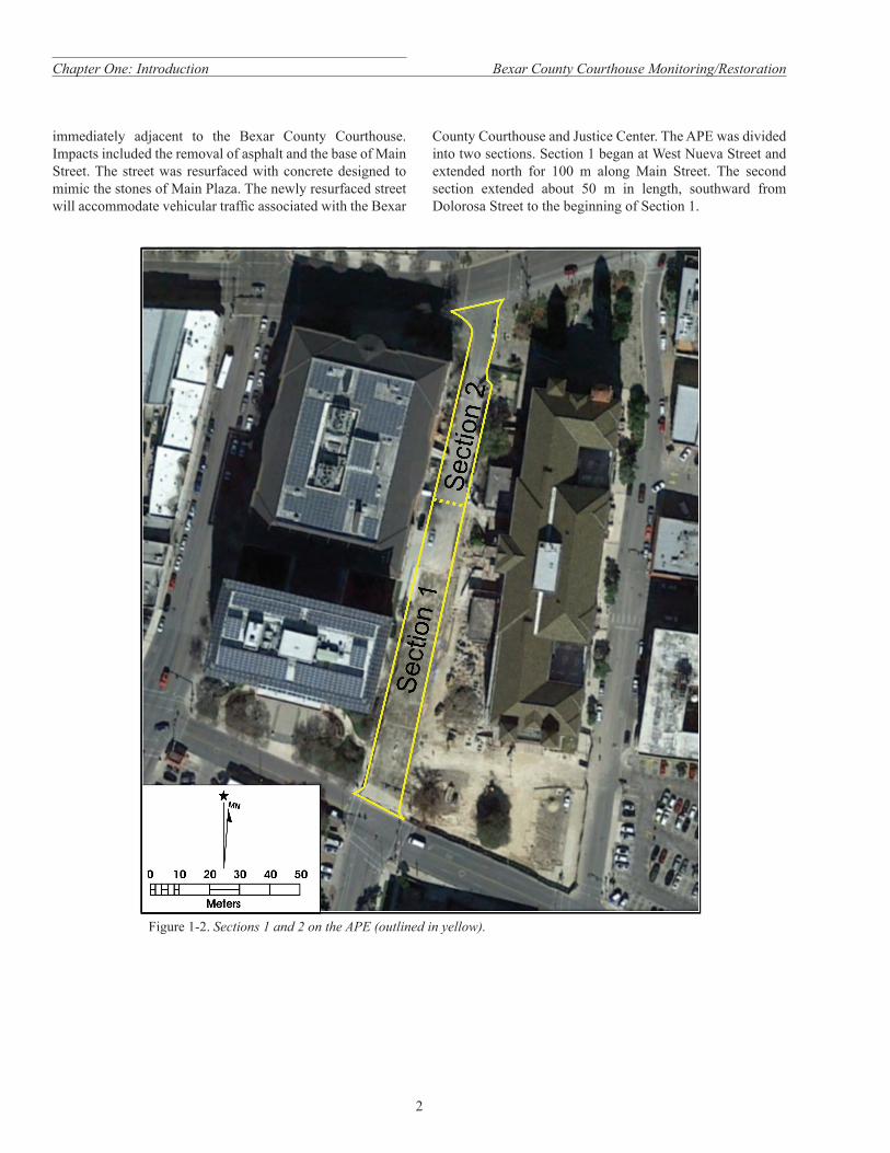
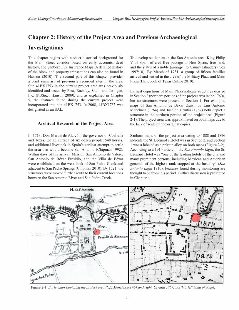
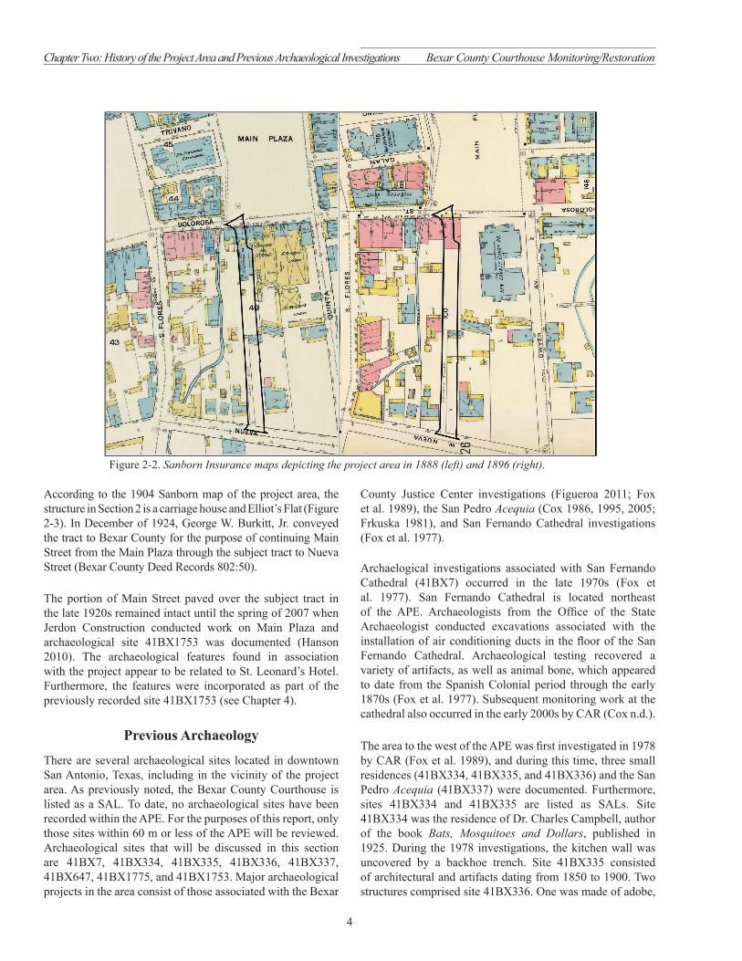
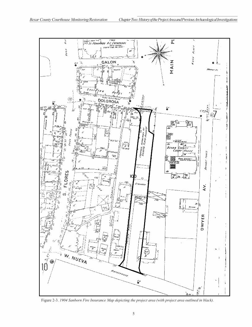
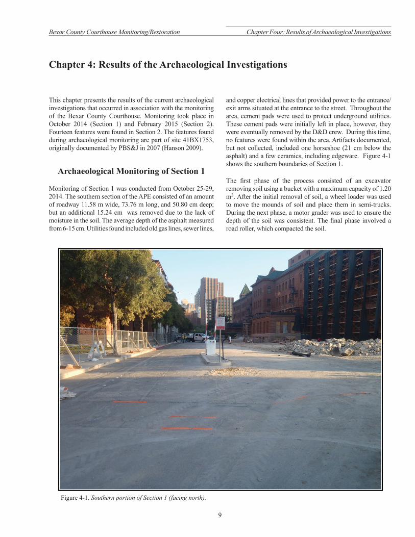
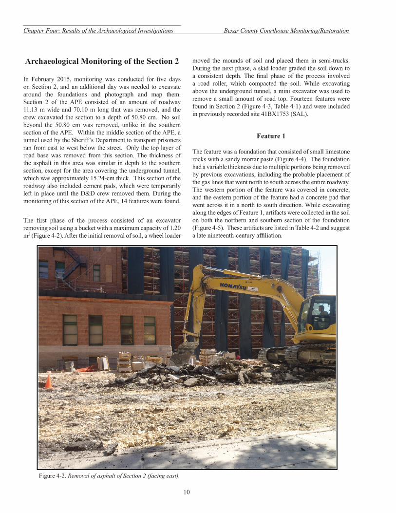
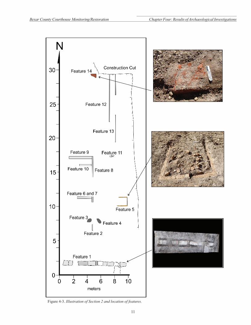
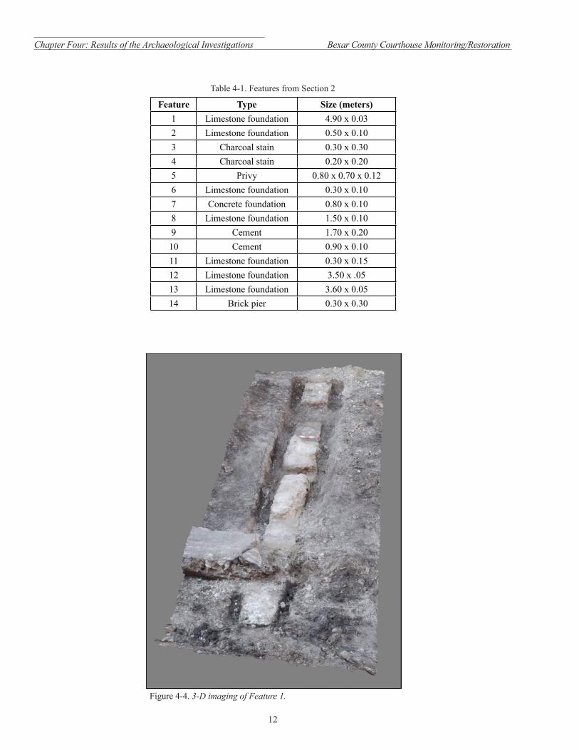
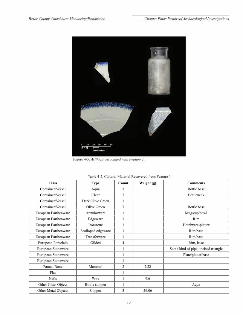
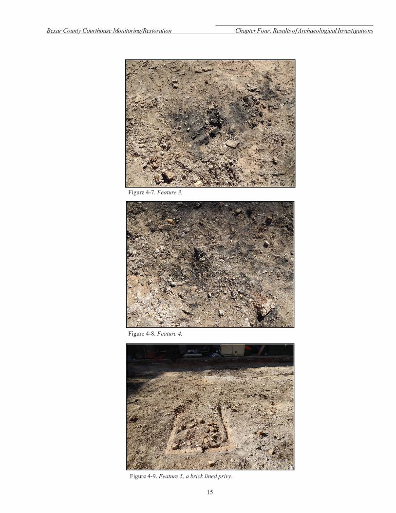
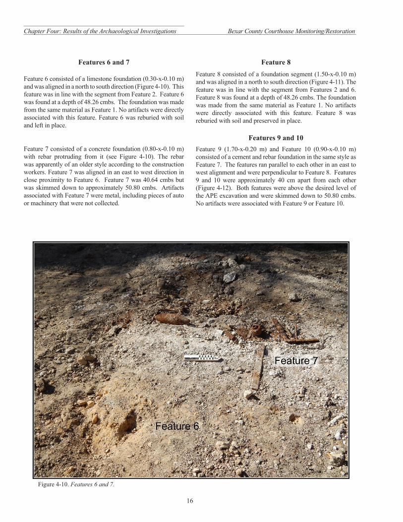
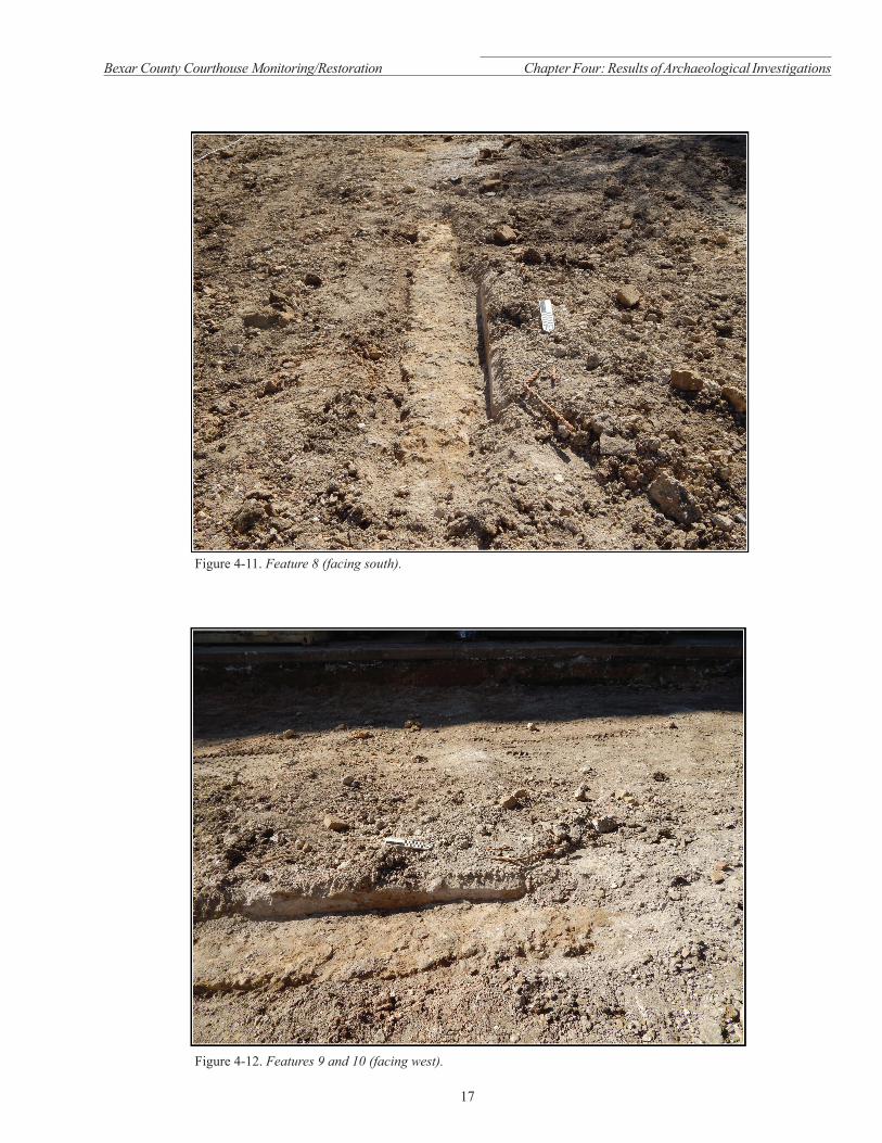
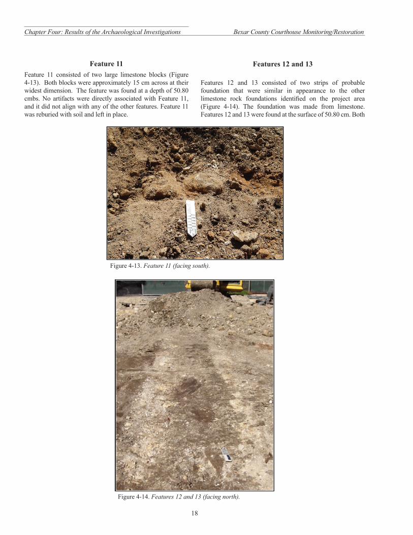