Embed Size (px)
Citation preview
2012 | Heritage Turkey | 21
Çaltılar Archaeological Project
Nicoletta Momigliano | University of BristolWith Alan Greaves, Belgin Aksoy, Tamar Hodos, AndrewBrown, Neil MacDonald and Pedar Foss
The overall goals of this project are to provide substantial newknowledge on the settlement history, material culture andenvironment of pre-Classical northern Lycia (Chalcolithic toEarly Iron Age, c. fourth to early first millennium BC), and toexplore the role of this region within the context of broadereastern Mediterranean–Anatolian–Aegean interactions inthese early periods. Developing from our work at ÇaltılarHöyük in 2008–2010 (see our 2011 article in AnatolianStudies), our 2012 season was largely devoted to the explo-ration of Eceler Höyük, a comparable site located about 12kmsouth of Çaltılar, next to the modern town of Seki and nearancient Oenoanda. In addition, we conducted further geomor-phological work at both Çaltılar and Eceler.
Eceler Höyük has never been systematically surveyedbefore, but it was reported as having Late Neolithic/EarlyChalcolithic, Early Bronze Age, Iron Age, Roman and possiblylater pottery, on the basis of previous limited collections ofsurface material. Çaltılar and Eceler also offer an interestingcontrast regarding their environmental contexts, with theformer being situated near a spring and a possibly marshy area,and the latter being adjacent to a river.
The specific objectives and activities of our 2012 seasonaimed at providing an initial assessment of the settlement atEceler, identifying areas where more intensive survey could becarried out in future seasons and supplying data for ourcontinuing environmental and landscape studies of this yaylaregion. Our activities, described in more detail below, included:(1) an assessment of the extent of the site of Eceler (rapid recon-naissance); (2) detailed topographic survey and aerial photo-graphy of the site; (3) geomorphological investigations in theenvirons of both Eceler and Çaltılar; (4) intensive surfacesurvey (collection of visible artefacts) at Eceler, using a seriesof transects across the site; (5) processing, recording andpreliminary study of all the recovered artefacts from theintensive survey, including sampling of ceramics for petro-graphic and other analyses; (6) outreach activities with thecommunity in Çaltılar.
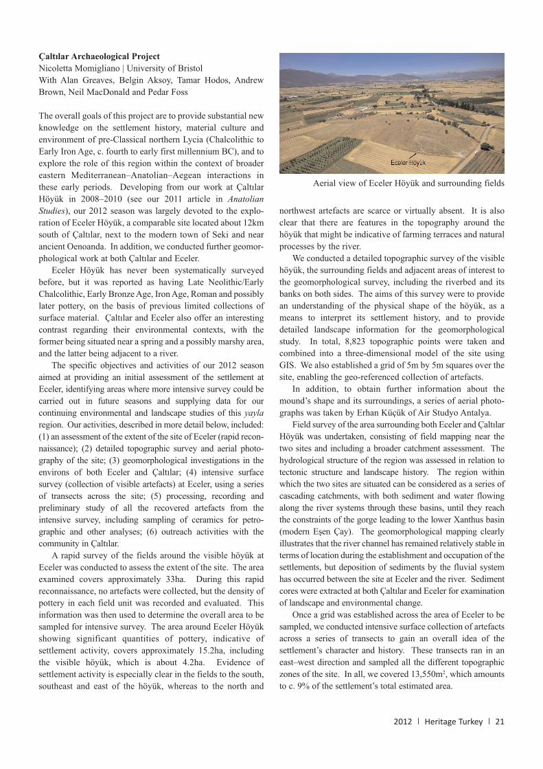
A rapid survey of the fields around the visible höyük atEceler was conducted to assess the extent of the site. The areaexamined covers approximately 33ha. During this rapidreconnaissance, no artefacts were collected, but the density ofpottery in each field unit was recorded and evaluated. Thisinformation was then used to determine the overall area to besampled for intensive survey. The area around Eceler Höyükshowing significant quantities of pottery, indicative ofsettlement activity, covers approximately 15.2ha, includingthe visible höyük, which is about 4.2ha. Evidence ofsettlement activity is especially clear in the fields to the south,southeast and east of the höyük, whereas to the north and
northwest artefacts are scarce or virtually absent. It is alsoclear that there are features in the topography around thehöyük that might be indicative of farming terraces and naturalprocesses by the river.
We conducted a detailed topographic survey of the visiblehöyük, the surrounding fields and adjacent areas of interest tothe geomorphological survey, including the riverbed and itsbanks on both sides. The aims of this survey were to providean understanding of the physical shape of the höyük, as ameans to interpret its settlement history, and to providedetailed landscape information for the geomorphologicalstudy. In total, 8,823 topographic points were taken andcombined into a three-dimensional model of the site usingGIS. We also established a grid of 5m by 5m squares over thesite, enabling the geo-referenced collection of artefacts.
In addition, to obtain further information about themound’s shape and its surroundings, a series of aerial photo-graphs was taken by Erhan Küçük of Air Studyo Antalya.
Field survey of the area surrounding both Eceler and ÇaltılarHöyük was undertaken, consisting of field mapping near thetwo sites and including a broader catchment assessment. Thehydrological structure of the region was assessed in relation totectonic structure and landscape history. The region withinwhich the two sites are situated can be considered as a series ofcascading catchments, with both sediment and water flowingalong the river systems through these basins, until they reachthe constraints of the gorge leading to the lower Xanthus basin(modern Eşen Çay). The geomorphological mapping clearlyillustrates that the river channel has remained relatively stable interms of location during the establishment and occupation of thesettlements, but deposition of sediments by the fluvial systemhas occurred between the site at Eceler and the river. Sedimentcores were extracted at both Çaltılar and Eceler for examinationof landscape and environmental change.
Once a grid was established across the area of Eceler to besampled, we conducted intensive surface collection of artefactsacross a series of transects to gain an overall idea of thesettlement’s character and history. These transects ran in aneast–west direction and sampled all the different topographiczones of the site. In all, we covered 13,550m2, which amountsto c. 9% of the settlement’s total estimated area.
Aerial view of Eceler Höyük and surrounding fields
22 | Heritage Turkey | 2012
We collected just over 8,000 pottery fragments and 375other finds, such as chipped stones, querns, burnt mud-brick,slag, etc. Ceramic samples were collected by Dr MustafaKibaroğlu for petrographic analyses. Our preliminary studyof these artefacts suggests the following main periods ofoccupation at the site.
Among the material collected in 2012, the earliest that wecould safely date can be assigned to the Late Chalcolithicperiod, and comprises pottery fragments such as lug handles,which find exact parallels in the Late Chalcolithic pottery ofBağbaşı in the Elmalı plain. Many sherds could be assignedto the Early Bronze Age, especially to the Early Bronze AgeII phase, such as bowl rims decorated in white paint on red orblack/grey burnished surfaces, closely comparable to material
found at Çaltılar and atKarataş in the Elmalıplain. An interestingfind, also assignable tothe Early Bronze Age, isa truncated bi-conicalspindle-whorl withincised decoration on abuff burnished surface,consisting of concentricarcs and an unusualfringed motif.
Unlike Çaltılar, Eceler Höyük has not yielded, so far, clearevidence for occupation in the second millennium BC. Onlyone fragment, belonging to a carinated bowl with handles seton the rim, could be assigned, very tentatively, to this period,but its small size and very poorly preserved surface cannotpreclude a later date (possibly Iron Age?). The Early, Middleand Late Iron Ages (c. 1100 to c. 550 BC) are represented atEceler Höyük through ceramic finds with parallels identifiedat Çaltılar and elsewhere. It is clear that during the seventhand sixth centuries BC, in particular, Eceler was connectedwith other regions, especially western Anatolia and the Greekworld, as shown by a number of imports.
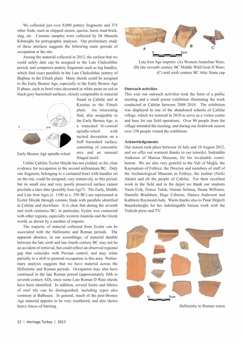
The majority of material collected from Eceler can beassociated with the Hellenistic and Roman periods. Theapparent absence, in our assemblage, of material datablebetween the late sixth and late fourth century BC may not bean accident of retrieval, but could reflect an observed regionalgap that coincides with Persian control, and may relatepartially to a shift to pastoral occupation in this area. Prelim-inary analysis suggests that we have material across theHellenistic and Roman periods. Occupation may also havecontinued in the late Roman period (approximately fifth toseventh century AD), since some Late Roman D Ware sherdshave been identified. In addition, several forms and fabricsof roof tile can be distinguished, including types alsocommon at Balboura. In general, much of the post-BronzeAge material appears to be very weathered, and also showsheavy traces of burning.
Outreach activities
This year our outreach activities took the form of a publicmeeting and a small poster exhibition illustrating the workconducted at Çaltılar between 2008–2010. The exhibitionwas displayed in one of the abandoned schools of Çaltılarvillage, which we restored in 2010 to serve as a visitor centreand base for our field operations. Over 80 people from thevillage attended the meeting, and during our fieldwork seasonover 150 people visited the exhibition.
Acknowledgements
Our season took place between 16 July and 10 August 2012,and we offer our warmest thanks to our temsilci, SadraddinAtukeren of Manisa Museum, for his invaluable contri-bution. We are also very grateful to the Vali of Muğla, theKaymakam of Fethiye, the Director and members of staff ofthe Archaeological Museum in Fethiye, the muhtar (NafizAktan) and all the people of Çaltılar. For their excellentwork in the field and in the depot we thank our studentsYasin Ezik, Gonca Tutuk, Osman Solmuş, Susan Williams,Danielle Bradshaw, Hege Usborne, Danica Anderson andKathleen Raymond-Judy. Warm thanks also to Pınar DöğerliBaşerkafaoğlu for her indefatigable liaison work with theTurkish press and TV.
Early Bronze Age spindle-whorl
Late Iron Age imports: (A) Western Anatolian Ware;(B) late seventh century BC Middle Wild Goat II Ware;
(C) mid sixth century BC Attic Siana cup
Hellenistic to Roman wares


![STRATEGIA ROZWOJU TRANSPORTU W · PDF filebd decydowa o rozwoju tego regionu. ... Opracowanie wasne na podstawie: [13]) ... • Bielsko Biaa](https://img.pdfslide.net/doc/110x75/5aba1bd97f8b9a297f8b482e/strategia-rozwoju-transportu-w-decydowa-o-rozwoju-tego-regionu-opracowanie.jpg)