Embed Size (px)
Citation preview

i
June 24, 2013 Sponsored By: Big Doctor Lake Association Aquatic Plant Advisory Committee Members: Bill Brice
Grace Haines
Helen Wilke
Dawn Richter
John Magnuson
Lynn Foss
Mary Munn
Mickey Nickelson
Tom Nickelson
Kathy Nickelson
Advisory Committee
Dave Ferris Burnett County Land and Water Conservation Department
Pamela Toshner Lakes & Rivers Management
Water Quality Biologist/Statewide Kathy Bartilson Aquatic Plant Management Coordinator WI DNR Prepared By Burnett County Land and Water Plan Writing and Facilitation Conservation Department Brad Morris, AIS Coordinator Proofing and editing Ann Lane, Administrative Assistant

ii
Table of Contents Introduction……………………………………………………………………..............................1 Public Input for Plan Development..........................................................................1 Lake Information......................…………………………………………………………............... 2 Water Quality...........................................................................................................4 Siren Waste Water Treatment Plant Effluent Flow Path Study ...............................6 Paleolimnology Study ............................................................................................11 Waste Water Treatment Plant Spring Dye Test…………………………………..20 Watershed ............................... .............................................................................21 Aquatic Habitats………………………………………………………………………………….24 Functions and Values of Native Aquatic Plants………………………………….24 Rare and Endangered Species Habitat ...................................................................26 Big Doctor Lake Fisheries ....................................................................................26 Plant Community ...........................................................................................................................27 Aquatic Plant Survey Results ................................................................................32 Curly Leaf Pondweed Bed Mapping Survey Results ...........................................35 Aquatic Plant Management ..........................................................................................................40 Discussion of Management Methods ....................................................................40 Plan Goals and Strategies .............................................................................................................51 Implementation Plan .............................................................................................61

iii
Tables Table 1. Lake Information.......................................................................................................3 Table 2. Secchi Readings........................................................................................................ 5 Table 3. Conductivity and Site Descriptions ..........................................................................7 Table 4. Diatoms of Big Doctor Lake (0-2 cm) ....................................................................15 Table 5: Diatoms of Big Doctor Lake (35-37 cm) ................................................................18 Table 6: Land Cover Classification found in the St. Croix Basin .........................................23 Table 7. NHI Species Found in Big Doctor Lake Area ........................................................26 Table 8. Big Doctor Lake Fish Species List .........................................................................26 Table 9. Big Doctor Lake Aquatic Macrophytes Survey......................................................37 Table 10. Big Doctor Lake FQI Species and Conservatism Values .......................................37 Table 11. Big Doctor Lake Species Frequencies and Mean Rake Fullness ............................39 Table 12. Implementation Plan ..............................................................................................61

iv
Figures Figure 1. Big Doctor Lake Map......................... ...................................................................... 4 Figure 2. Big Doctor Lake Secchi Depth Averages .................................................................6 Figure 3. Site Number and Conductivity Values .....................................................................9 Figure 4: Watershed Boundaries of WWTP ...........................................................................10 Figure 5: Common Diatoms found in Big Doctor Lake .........................................................13 Figure 6: Comparison of Species Abundances’ ......................................................................14 Figure 7: May 13, 2013 Dye and Conductivity Test ..............................................................21 Figure 8. Clam River Watershed ............................................................................................22 Figure 9. Clam River Watershed ............................................................................................22 Figure 10. Clam River Watershed Land Cover ........................................................................24 Figure 11. Big Doctor Lake Sample Grid ................................................................................27 Figure 12. May Survey Results for Curly leaf Pondweed ........................................................28 Figure 13. Rake Fullness Rating ...............................................................................................29 Figure 14. Big Doctor Lake Littoral Zone ................................................................................33 Figure 15. Big Doctor Lake Sediment Types ...........................................................................33 Figure 16. Big Doctor Lake’s Most Common Species .............................................................34 Figure 17. Curly-leaf pondweed Distribution ...........................................................................35 Figure 18. June CLP Survey Results ........................................................................................58 Figure 19: July CLP Survey Results .........................................................................................59 Figure 20: Figure 20: CLP Survey June 10, 2014..……………………………………………60
v
Appendices Appendix A Big Doctor Lake User Survey ...............................................................................A-1 Appendix B Aquatic Plant Maps of Big Doctor Lake ...............................................................B-1 Appendix C Rapid Response for Early Detection of Eurasian water milfoil ............................C-1 Appendix D Management Options for Aquatic Plants ..............................................................D-1 Appendix E Aquatic Plant Management Strategy .....................................................................E-1 Appendix F Core Sample Report …..........................................................................................F-1 Appendix G References………………………………………………………………………...G-1
1
Introduction
The Aquatic Plant Management Plan for Big Doctor Lake is sponsored by the Big Doctor Lake Association. The planning phase of the project is funded, in part, by the Burnett County Land and Water Conservation Department and the Big Doctor Lake Association.
Knowing that Eurasian water milfoil (Myriophyllum spicatum) is found in several lakes in Burnett and Washburn County, concerned members of the Big Doctor Lake Association authorized an extensive assessment of Big Doctor Lake aquatic macrophytes using the Wisconsin Department of Natural Resources statewide guidelines for conducting systematic point intercept macrophyte sampling. This Aquatic Plant Management Plan for Big Doctor Lake presents a strategy for managing aquatic plants by protecting native plant populations and preventing the establishment of invasive species. The plan includes data about the plant community, watershed, and water quality, as well as other non plant species. Based on this data and public input, goals and strategies for the sound management of aquatic plants in Big Doctor Lake are presented. This plan will guide the Big Doctor Lake Association, Burnett County, and the Wisconsin Department of Natural Resources in aquatic plant management for Big Doctor Lake over the next five years (from 2013 through 2018).
Public Input for Plan Development
On June 16th, 2012, members of the Big Doctor Lake Association met to discuss the process of creating an Aquatic Plant Management (APM) Plan. At this meeting, a tentative Aquatic Plant Advisory Committee was established. Furthermore, the recommendation of additional committee members was discussed with the assumption that additional members would be added in the near future. During this meeting a date was established (August 13, 2011) to hold a kick-off meeting. An announcement was sent to each lake home resident informing them about the meeting, including time and location. Additionally, at the first meeting, those present reviewed aquatic plant management planning requirements and discussed initial concerns.
On July 14, 2012, a Public meeting was held to discuss the concerns of Big Doctor Lake and to establish those concerns as the primary focus of writing the Aquatic Plant Management Plan for the lake. Prior to the meeting date, a Public Notice was advertised for three weeks in the Burnett County Sentinel and Inter County Leader. A total of 16 people were present for the meeting. Minutes of the meeting were recorded. A summary of the concerns are listed below:
• Protect, prevent and control the spread of aquatic invasive species such as Zebra mussels and Eurasian water milfoil
• Control and prevent nutrient run-off/shore land preservation/restoration • Mass education on various subjects related to protecting and preserving this natural
resource, including wildlife and fish species enhancement • Boat landing inspections • Issues concerning the amount of Eurasian water milfoil in Burnett County
2
In addition to the kick-off meeting, a survey was sent out to all Riparian land owners. A total of 34 surveys were sent out and a total of 29 were returned. See Appendix A for survey details. A brief meeting was held immediately after the Kick-off meeting to establish a committee. The Big Doctor Lake Association board announced the availability of the draft Aquatic Plant Management Plan for review by June 24, 2013. Copies will be available at the following locations: Burnett County Government Center Land and Water Conservation Department Room 21, online at the Burnett County Website, and from Big Doctor Lake Aquatic Plant Management committee members. Comments and suggestions can be mailed or emailed to the address/addresses below.
Lake Information
Big Doctor Lake (WBIC 2453400) is a 213.2 acre seepage lake located in Burnett County, T38N R16W. It has a maximum depth of 9 FEET and a MEAN depth of 6 FEET. The substrate of the lake bottom is comprised of 50% sand and 50% muck. Features include a public boat landing. Fish in the lake include Panfish, Largemouth Bass, Northern Pike. Secchi disk readings have not been recorded; therefore, water clarity is not certain. Chemistry data has not recently been collected and during a presentation on June 16th, the association members were encouraged to start collecting data.
Schedule for Plan Completion: June 24, 2013
Final draft for DNR and public review by Janruary 13, 2014 Comments accepted on the plan through July 15, 2013
Send comments via mail or email to:
Brad Morris Burnett County Land and Water Conservation Department 7410 County Road K, #109 Siren, WI 54872 [email protected] Board meeting to review comments TBD
3
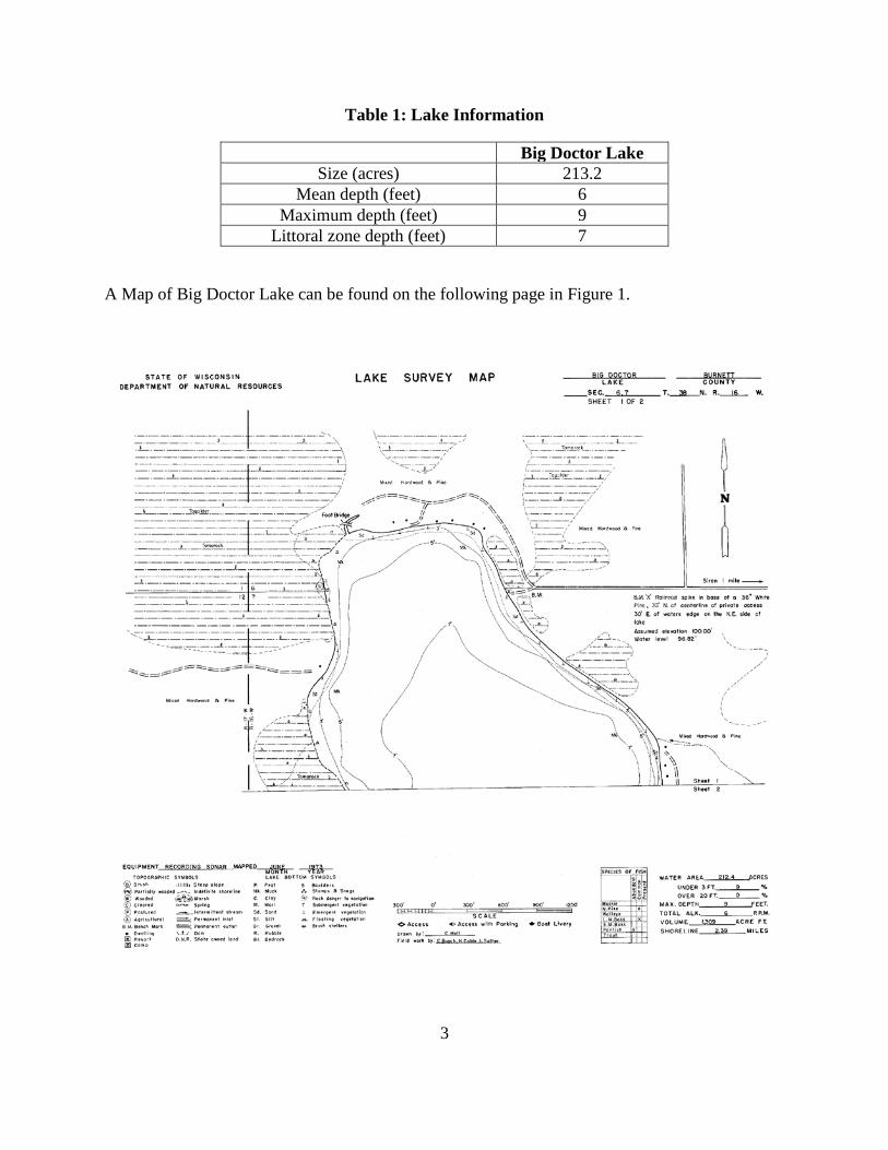
Table 1: Lake Information
Big Doctor Lake Size (acres) 213.2
Mean depth (feet) 6 Maximum depth (feet) 9
Littoral zone depth (feet) 7
A Map of Big Doctor Lake can be found on the following page in Figure 1.

4
Figure 1: Big Doctor Lake Map Figure 1: Mudhen Lake Map (WI DNR)
Water Quality
Water quality is frequently reported by the trophic state or nutrient level of the lake. Nutrient-rich lakes are classified as eutrophic. These lakes tend to have abundant aquatic plant growth and low water clarity due to algae blooms. Mesotrophic lakes have intermediate nutrient levels and only occasional algae blooms. Oligotrophic lakes are nutrient-poor with little growth of plants and algae.
Secchi depth readings are one way to assess the trophic state of a lake. The Secchi depth is the depth at which the black and white Secchi disk is no longer visible when it is lowered into the water. Greater Secchi depths occur with greater water clarity. Secchi depth readings, phosphorus

5
concentrations, and chlorophyll measurements can each be used to calculate a Trophic State Index (TSI) for lakes. TSI values range from 0 – 110. Lakes with TSI values greater than 50 are considered eutrophic. Those with values in the 40 to 50 range are mesotrophic. Lakes with TSI values below 40 are considered oligotrophic.
In 2009, Big Doctor Lake established a Lake Association and in 2012 organized a citizen lake monitoring network to collect Secchi and water chemistry data. Below is a narrative of the 2012 results. Big Doctor Lake - Deep Hole was sampled 16 different days during the 2012 season. Parameters sampled included:
• water clarity • temperature • dissolved oxygen • total phosphorus • chlorophyll
The average summer (July-Aug) secchi disk reading for Big Doctor Lake - Deep Hole (Burnett County, WBIC: 2453400) was 2.39 feet. The average for the Northwest Georegion was 7.5 feet. Typically the summer (July-Aug) water was reported as MURKY and BROWN. With this particular lake, it is important to note that the Secchi disc hit the bottom of the lake for 2 of the Secchi readings during the 2012 monitoring season. This indicates that the water clarity was actually greater than the Secchi readings imply. This suggests that the secchi depth may have been mostly impacted by suspended sediments, tiny particles of soil or organic matter that are suspended in the water. Shallow lakes are often turbid because wind stirs up sediment from the bottom. High suspended sediments are often found in flowages and impoundments where precipitation runoff from the watershed transports solids via an incoming stream. Chemistry data was collected on Big Doctor Lake - Deep Hole. The average summer Chlorophyll was 94.6 µg/l (compared to a Northwest Georegion summer average of 110.7 µg/l). The summer Total Phosphorus average was 107 µg/l. Lakes that have more than 20 µg/l and impoundments that have more than 30 µg/l of total phosphorus may experience noticeable algae blooms. The overall Trophic State Index (based on chlorophyll) for Big Doctor Lake - Deep Hole was 69. The TSI suggests that Big Doctor Lake - Deep Hole was eutrophic. This TSI usually suggests blue-green algae become dominant and algal scums are possible, extensive plant overgrowth problems possible. (WI DNR)
Table 2: Secchi Readings on Big Doctor Lake from 2001-2012

6
Figure 2: Past Secchi Readings of Big Doctor Lake
Waste Water Treatment Plant Effluent Study The following is a narrative written by Craig Roesler, WI DNR Lakes Biologist SIREN WWTP EFFLUENT FLOW PATH EVALUATION MAY 8, 2012 The Siren (Burnett Co.) wastewater treatment plant outfall and the surrounding area were observed on May 8, 2012 by Craig Roesler and Kathy Bartilson of the DNR. The goal of the visit was to determine the path of effluent flow from the outfall point. The effluent discharges to a large wetland area so it is not possible to continuously follow the effluent from the outfall. Past assessments have produced varying results. Some have concluded effluent flows north through the wetland toward Big Doctor Lake. Others have concluded effluent flows south through the wetland to two small ponds near the northwest corner of Clear Lake. Frequent and substantial precipitation had occurred prior to May 8, 2012 and water levels in wetlands other surface waters were fairly high. Clear Lake was at the level of its overflow point along STH 35. A meter was used to measure conductivity at various points to help determine how water and effluent was moving. Visual observations of flow direction were also made. A water sample was collected at the unnamed tributary to Big Doctor Lake at the STH 70 culvert (site 2, below). The sample was tested for total phosphorus, chloride, and sulfate.

7
Conductivity was measured at 12 sites (figure 3). Conductivities and site descriptions are listed below: Table 3: Conductivity and Site Descriptions Site No.
Conductivity (umhos/cm)
Site Description
1 753 Siren WWTP effluent outfall 2 269 Unnamed tributary to Big Doctor L. @ STH 70 3 235 Highway ditch 30 ft west of site 2 4 220 Highway ditch 30 ft east of site 2 5 85 Wetland 150 ft east and 40 ft south of site 2 6 40 Clear Lake @ northwest and northeast corners 7 125 West shore of south pond 8 133 Culvert draining wetland on west side of Gandy Dancer trail 9 48 Wetland edge east of Gandy Dancer Trail 10 156 Outlet channel of north pond 11 55 Wetland ½ way between outlet channel and wetland edge 12 157 West shore of north pond Flow for the unnamed tributary to Big Doctor Lake at STH 70 (site 2) was estimated at 0.55 cfs, and was moving northward toward the lake. A slight odor of wastewater effluent was noticeable. Wastewater effluent discharge was reported to be 0.158 cfs. Flow was also observed in a small short channel at the northeast end of the north pond (site 10). A slight flow was moving to the northeast, out of the pond. The water levels in Clear Lake and in the south pond were observed from the Gandy Dancer trail. The water level in the south pond was clearly a few feet lower than the water level in Clear Lake. The watershed for the ponds (figure 2) is about 150 acres, most of which is upland area with loamy sand soils, and is likely to be contributing groundwater inflow to the ponds. The ponds cannot be the receiving waters for the wastewater effluent because:
- There is no flow path for water to travel southward beyond the ponds, except as infiltration to groundwater and this appears unlikely.
- Clear Lake has a higher water level than the ponds. Some seepage from Clear Lake may flow to the ponds.
- Flow was observed to be leaving the ponds and moving to the northeast. Conductivity measurements also indicate wastewater effluent is flowing northward toward STH 70 and Big Doctor Lake, rather than south to the ponds. Wastewater effluent has a very high
8
conductivity (753 umhos/cm; site 1). Wetland conductivities were low (48-85 umhos/cm; sites 5, 9, 11). Conductivity at sites within the pool area of the two ponds had moderate conductivities (125-157 umhos/cm; sites 7, 8, 10, 12). The ponds are probably receiving groundwater inflow from their watershed (figure 2). Groundwater generally has higher conductivities than surface water drainage. Conductivity was high (269 umhos/cm) at site 2 at STH 70, which suggests effluent has been diluted with water of lower conductivity at that point. Based on the wastewater effluent flow rate and the flow rate observed at site 2, 28% of the flow at site 2 was composed of effluent. Mixing calculations indicate the background water that is mixed with effluent has a conductivity of about 74 umhos/cm. This is within the range of conductivities found within the upgradient wetland area, including the ponds (48- 157). This is further evidence that effluent is flowing northward toward STH 70. Conductivity at the road ditch sites (220-235 umhos/cm; sites 3 and 4) were similar to that in the tributary channel at the culvert, suggesting that tributary channel water had diffused or back-flowed into the ditch. The water sample collected at the STH 70 culvert also indicates wastewater effluent is flowing to that location. The total phosphorus concentration (1.39 mg/l) and the chloride concentration (59.6) were very high. The total phosphorus concentration is very close to what would be expected if wastewater effluent with an assumed total phosphorus concentration of 5.0 mg/l composed 28% of the flow at the site. Wastewater effluent often has a chloride concentration of about 100 mg/l. The very high chloride concentration suggests both wastewater effluent and road salt from STH 70 and 35 are sources. The sulfate concentration was 16.8 mg/l. The sulfate concentration of the wastewater effluent is not known. Big Doctor Lake (WBIC 2452400), which is receiving the wastewater effluent, has an area of 212 acres and a maximum depth of 9 feet. Two lake samples are on record from 2001: May 10, 2001
- total phosphorus = 57 ug/l - Secchi depth = 3.5 ft.
August 27, 2001 - total phosphorus = 46 ug/l - chlorophyll a = 87 ug/l - Secchi depth = 2 ft. - Color = 60 Pt-Co units - Total nitrogen = 1.74 mg/l

9
These values indicate highly eutrophic conditions. The recreational impairment thresholds for listing shallow lakes on the 303d list of impaired waters are 40 ug/l for total phosphorus, and 25 ug/l for chlorophyll a. Three total phosphorus samples collected in each of 2 years is the minimum documentation currently required to place a lake on the 303d list. It is very likely that Big Doctor Lake would qualify for 303d listing if the required monitoring was done.
Figure 3: Site Number and Conductivity Values

10
Figure 4: Watershed Boundaries of WWTP

11
Paleolimnology Study Additionally, in the fall of 2013, a paleolimnological analysis was conducted to help understand the water quality changes that have occurred on the lake. Below is a summary of the study conducted by Paul Garrison, Lakes Biologist with the Wisconsin Department of Natural Resources. RESULTS OF SEDIMENT CORE TAKEN FROM BIG DOCTOR LAKE- AUGUST 29, 2012, BURNETT COUNTY, WISCONSIN Paul Garrison , Wisconsin Department of Natural Resources April 2013 Aquatic organisms are good indicators of a lake’s water quality because they are in direct contact with the water and are strongly affected by the chemical composition of their surroundings. Most indicator groups grow rapidly and are short lived so the community composition responds rapidly to changing environmental conditions. One of the most useful organisms for paleolimnological analysis are diatoms. These are a type of algae which possess siliceous cell walls, which enables them to be highly resistant to degradation and are usually abundant, diverse, and well-preserved in sediments. They are especially useful, as they are ecologically diverse. Diatom species have unique features as shown in Figure 1, which enable them to be readily identified. Certain taxa are usually found under nutrient poor conditions while others are more common under elevated nutrient levels. Some species float in the open water areas while others grow attached to objects such as aquatic plants or the lake bottom. By determining changes in the diatom community it is possible to determine water quality changes that have occurred in the lake. The diatom community provides information about changes in nutrient concentrations, water clarity, and pH conditions as well as alterations in the aquatic plant (macrophyte) community. On 29 August 2012 a sediment core were taken from near the deep area (N45.74348° W92.39800°) of Big Doctor Lake using a gravity corer. Samples from the top of the core (0-1 cm) and a section (35-37 cm) deeper in the core were kept for analysis. It is assumed that the upper sample represents present conditions while the deeper sample is indicative of water quality conditions at least 100 years ago. A radiochemical analysis of the bottom sample will be conducted to determine if the sample was deposited at least 100 years ago. This analysis will not be completed until the fall of 2013. Results In Big Doctor Lake the presettlement diatom community was dominated by diatoms of the group Eunotia (Figure 2). These diatoms are typically found in pH environments that are slightly acidic and often are dominant in northern WI wetlands. In the top sample these diatoms were much less common. Instead the community was dominated by taxa that are more common at higher pH values. Common diatoms were Aulacoseira ambigua (Figure 1a), Achnanthidium minutissima,

12
and the group benthic Fragilaria (Figure 2). The latter two diatoms are typically found attached to macrophytes. The diatom community indicates that the present day pH level is higher than the historical level. This may be the result of increased sediment and nutrient inputs to the lake. A study in north central WI found that a consequence of shoreland development was increased delivery sediment materials which resulted in an increase in the lake’s pH. This seems to have occurred in Big Doctor Lake. The increase in benthic Fragilaria and A. minutissima indicate there are more submerged aquatic plants (SAV) at the present time. In northern WI, many lakes with shoreline development have experienced an increase in SAV. Dr. Susan Borman recently conducted a study in lakes in the northwestern part of WI where she compared the SAV community in the 1930s with the present day community. She found that lakes with cottages have more plants and the species have shifted to those that are larger and grow closer to the lake’s surface. This same thing has occurred in southern and central WI but often these lakes have higher phosphorus loading rates and planktonic diatoms become more important. The change in the plant community appears to have happened in Big Doctor Lake as the top sample has more diatoms that typically are associated with aquatic plants. Diatom assemblages historically have been used as indicators of nutrient changes in a qualitative way. In recent years, ecologically relevant statistical methods have been developed to infer environmental conditions from diatom assemblages. These methods are based on multivariate ordination and weighted averaging regression and calibration. Ecological preferences of diatom species are determined by relating modern limnological variables to surface sediment diatom assemblages. The species-environment relationships are then used to infer environmental conditions from fossil diatom assemblages found in the sediment core. Such a model was applied to the diatom community in the core from Big Doctor Lake. The model estimates a summer phosphorus concentration of about 25 µg L-1 which is much lower than has been measured in the last few years. The concentration measured in 2012 was generally between 80-90 µg L-1. The model significantly underestimates the present day phosphorus levels so the modeled estimates of historical phosphorus concentrations of 13-15 µg L-1 are suspect. Judging from the change in the diatom community I would speculate that present day phosphorus levels are higher than historical ones but I do not know how much higher they are. In summary, the sediment core indicates that there has been an increase the pH level in the lake and at the present time the aquatic plant community is greater than it was historically. Although the modeling indicates summer phosphorus levels have increased from 13 to 25 µg L-1 this is suspect since the present day concentration is underestimated. It is likely that phosphorus levels have increased but it is difficult to know what the historical levels were.

13
Figure (5). Photomicrographs of the diatoms commonly found in the Big Doctor Lake sediment core. The top diatom, Aulacoseira ambigua (A), is found in the open water environments, the bottom left diatoms are part of the benthic Fragilaria (B), while the bottom right diatom (Eunotia incisa) is found in lower pH environments. Benthic Fragilaria are commonly found attached to substrates such as aquatic plants.
Figure 5: Common Diatoms found in Big Doctor Lake
A
C B

14
Figure (6). Changes in the abundance of important diatoms found at the top and bottom of the Big Doctor Lake sediment core. The dominant diatoms at the bottom of the core were Eunotica which are typically found in lower pH environments. At the top of the core the diatoms that grow attached to aquatic plants are more common. This indicates an increase in growth of submerged aquatic vegetation. Aulacoseira are found floating the open water and probably indicate higher nutrient levels.
Figure 6: Comparison of Species Abundances’
TOP
BOTTOM
TOP
BOTTOM
Eunotia spp.
0 10 20 30 40
Achnanthidium minutissima
0 10 20
Aulacoseira spp.
0 5 10
Benthic Fragilaria
0 10 20 30 40

15
Table 4: Diatoms of BIG DOCTOR LAKE (0-2) Burnett County
Top (0-2 cm)
COUNT TOTAL
Number Prop. TAXA
Achnanthidium altergracillima (Lange-Bertalot) Round et Bukhtiyarova 2 0.004 Achnanthidium minutissimum (Kützing) Czarnecki 87 0.174 Achnanthidium rivulare Potapova et Ponader 2 0.004 Aulacoseira ambigua (Grunow in Van Heurck) Simonsen 13 0.026 Aulacoseira distans (Ehrenberg) Simonsen 1 0.002 Aulacoseira italica (Ehrenberg) Simonsen 5 0.010 Aulacoseira spp. 2 0.004 Brachysira microcephala (Kützing) Compère 5 0.010 Brachysira serians (Brébisson) Round et Mann 1 0.002 Brachysira spp. 1 0.002 Cavinula pseudoscutiformis (Hustedt in Schmidt et al.) Mann et Stickle in Round, Crawford and Mann 1 0.002 Cocconeis placentula Ehrenberg 9 0.018 Cocconeis spp. 6 0.012 Cymbella mesiana Cholnoky 2 0.004 Cymbella naviculiformis Auerswald ex Heiberg 1 0.002 Cymbella spp. 2 0.004 Discostella stelligera (Cleve et Grunow in Cleve) Houk et Klee 1 0.002 Encyonema minutum (Hilse in Rabenhorst) Mann in Round, Crawford and Mann 5 0.010 Eunotia bilunaris (Ehrenberg) Souza in Souza and Moreira-Filho 1 0.002 Eunotia circumborealis Lange-Bertalot et Nörpel in Lange-Bertalot 6 0.012 Eunotia incisa Smith ex Gregory 13 0.026 Eunotia minor (Kützing) Grunow in Van Heurck 4 0.008 Eunotia parallela Ehrenberg 2 0.004 Eunotia serra Ehrenberg 1 0.002 Eunotia spp. 6 0.012 Fragilaria radians (Kützing) Williams et Round 9 0.018 Fragilaria sepes Ehrenberg 1 0.002 Fragilaria tenera (Smith) Lange-Bertalot 4 0.008 Gomphonema anjae Lange-Bertalot & Reidhardt 1 0.002 Gomphonema exilissimum (Grunow in Van Heurck) Lange-Bertalot et Reichardt in Lange-Bertalot and Metzeltin 3 0.006 Gomphonema parvulum (Kützing) Kützing 2 0.004 Gomphonema parvulum fo. saprophilum Lange-Bertalot et Reichardt in Lange-Bertalot 1 0.002 Gomphonema spp. 3 0.006 Hantzschia amphioxys (Ehrenberg) Grunow in Cleve and Grunow 1 0.002 Navicula joubaudii Germain 4 0.008

16
Table 4: Continued Burnett County
Top (0-2 cm)
COUNT TOTAL
Number Prop.
TAXA Navicula leptostriata Jørgensen 4 0.008
Navicula minima Grunow in Van Heurck 2 0.004 Navicula spp. 7 0.014 Navicula subminuscula Manguin 7 0.014 Navicula utermoehlii Hustedt in A. Schmidt 4 0.008 Neidium bisulcatum (Lagerstedt) Cleve 2 0.004 Neidium spp. 2 0.004 Nitzschia dissipata var. media (Hantzsch) Grunow in Van Heurck 2 0.004 Nitzschia palea var. debilis (Kützing) Grunow in Cleve and Grunow 1 0.002 Nitzschia spp. 7 0.014 Nupela fennica (Hustedt) Lange-Bertalot in Krammer and Lange-Bertalot 2 0.004 Nupela impexiformis (Lange-Bertalot in Lange-Bertalot and Krammer) Lange-Bertalot 5 0.010 Nupela sp. 1 ? 6 0.012 Nupela vitiosa (Schimanski) Siver et Hamilton 10 0.020 Nupela wellneri (Lange-Bertalot in Lange-Bertalot and Krammer) Lange-Bertalot in U. Rumrich, Lange-Bertalot and M. Rumrich 2 0.004 Pinnularia rupestris Hantzsch in Rabenhorst 1 0.002 Pinnularia spp. 7 0.014 Psammothidium subatomoides (Hustedt in Schmidt) Bukhtiyarova et Round 2 0.004 Pseudostaurosira brevistriata (Grunow in Van Heurck) Williams et Round 63 0.126 Punctastriata mimetica Morales 2 0.004 Sellaphora disjuncta (Hustedt) Mann 2 0.004 Sellaphora laevissima (Kützing) Mann 2 0.004 Sellaphora pupula (Kützing) Meresckowsky 2 0.004 Sellaphora rectangularis (Gregory) Lange-Bertalot et Metzeltin 1 0.002 Sellaphora seminulum (Grunow) Mann 9 0.018 Sellaphora sp. 1 ? 1 0.002 Stauroforma exiguiformis (Lange-Bertalot) Flower, Jones et Round 2 0.004 Stauroneis anceps fo. gracilis Rabenhorst 1 0.002 Stauroneis spp. 2 0.004 Staurosira construens var. venter (Ehrenberg) Hamilton in Hamilton, Poulin, Charles and Angell 38 0.076 Staurosirella pinnata (Ehrenberg) Williams et Round 52 0.104 Synedra delicatissima var. angustissima Grunow in Van Heurck 5 0.010 Synedra minuscula Grunow in Van Heurck 4 0.008 Synedra rumpens Kützing 4 0.008 Synedra spp. 2 0.004 Tabellaria flocculosa (strain III) sensu Koppen (Roth) Kützing 7 0.014 Tabellaria flocculosa var. linearis Koppen 1 0.002

17
Table 4: Continued Burnett County
Top (0-2 cm)
COUNT TOTAL
Number Prop.
TAXA
Tabellaria spp. 2 0.004 Tabellaria ventricosa Kützing 1 0.002 Tryblionella scalaris (Ehrenberg) Siver et Hamilton 1 0.002 unknown pennate 15 0.030 TOTAL 500 1.000

18
Table 5: Diatoms of BIG DOCTOR LAKE (35-37) Burnett County
Bottom (35-37 cm) lots of diatoms fragments; sponge spicules and phytoliths
COUNT TOTAL
Number Prop.
TAXA
Achnanthidium altergracillima (Lange-Bertalot) Round et Bukhtiyarova 1 0.002 Achnanthidium minutissimum (Kützing) Czarnecki 3 0.006 Aulacoseira italica (Ehrenberg) Simonsen 2 0.004 Aulacoseira nygaardii (Camburn in Camburn and Kingston) Camburn et Charles 1 0.002 Cymbella mesiana Cholnoky 2 0.004 Cymbella spp. 3 0.006 Encyonema minutum (Hilse in Rabenhorst) Mann in Round, Crawford and Mann 7 0.014 Encyonema silesiacum (Bleisch in Rabenhorst) Mann in Round, Crawford and Mann 4 0.008 Encyonopsis sp. 1 ? 11 0.021 Eunotia bilunaris (Ehrenberg) Souza in Souza and Moreira-Filho 1 0.002 Eunotia carolina Patrick 38 0.074 Eunotia circumborealis Lange-Bertalot et Nörpel in Lange-Bertalot 1 0.002 Eunotia faba (Ehrenberg) Grunow in Van Heurck 3 0.006 Eunotia flexuosa (Brébisson ex Kutzing) Kützing 24 0.047 Eunotia formica Ehrenberg 7 0.014 Eunotia hexaglyphis Ehrenberg 4 0.008 Eunotia implicata Nörpel, Alles et Lange-Bertalot in Alles, Nörpel and Lange-Bertalot 2 0.004 Eunotia incisa Smith ex Gregory 79 0.154 Eunotia intermedia (Krasske ex Hustedt) Nörpel et Lange-Bertalot in Lange-Bertalot 6 0.012 Eunotia parallela Ehrenberg 1 0.002 Eunotia praerupta Ehrenberg 6 0.012 Eunotia rhomboidea Hustedt 3 0.006 Eunotia spp. 11 0.021 Fragilaria famelica (Kützing) Lange-Bertalot 1 0.002 Fragilaria vaucheriae (Kützing) Petersen 2 0.004 Gomphonema acuminatum Ehrenberg 7 0.014 Gomphonema auritum Braun & Kutzing 1 0.002 Gomphonema exilissimum (Grunow in Van Heurck) Lange-Bertalot et Reichardt in Lange-Bertalot and Metzeltin 3 0.006 Gomphonema gracile Ehrenberg 11 0.021

19
Table 5: Continued Burnett County
Bottom (35-37 cm) lots of diatoms fragments; sponge spicules and phytoliths
COUNT TOTAL
Number Prop. TAXA
Gomphonema hebridense Gregory 1 0.002 Gomphonema maclaughlinii Reichardt 4 0.008 Gomphonema minutum (Agardh) Agardh 16 0.031 Gomphonema minutum fo. curtum (Hustedt) Lange-Bertalot et Reichardt in Krammer and Lange-Bertalot 7 0.014 Gomphonema parvulius (Lange-Bertalot et Reichardt) Lange-Bertalot et Reichardt in Lange-Bertalot and Metzeltin 9 0.018 Gomphonema parvulum (Kützing) Kützing 2 0.004 Gomphonema sp. 1 Big Doctor 3 0.006 Gomphonema sp. 26 NAWQA EAM 1 0.002 Gomphonema spp. 10 0.020 Gomphonema truncatum Ehrenberg 3 0.006 Hantzschia amphioxys (Ehrenberg) Grunow in Cleve and Grunow 1 0.002 Navicula spp. 4 0.008 Navicula vulpina Kützing 21 0.041 Neidium ampliatum (Ehrenberg) Krammer in Krammer and Lange-Bertalot 1 0.002 Neidium spp. 13 0.025 Neidium temperei Reimer 3 0.006 Pinnularia maior (Kützing) Rabenhorst 2 0.004 Pinnularia microstauron (Ehrenberg) Cleve 2 0.004 Pinnularia pseudogibba Krammer 4 0.008 Pinnularia spp. 7 0.014 Pinnularia subgibba Krammer 3 0.006 Pinnularia viridiformis Krammer 6 0.012 Pinnularia viridis (Nitzsch) Ehrenberg 1 0.002 Sellaphora americana (Ehrenberg) Mann 2 0.004 Sellaphora laevissima (Kützing) Mann 5 0.010 Sellaphora pupula (Kützing) Meresckowsky 3 0.006 Sellaphora rectangularis (Gregory) Lange-Bertalot et Metzeltin 9 0.018 Sellaphora rugula (Hohn & Hellerman) Potapova & Ponader 1 0.002 Sellaphora spp. 3 0.006 Stauroneis anceps Ehrenberg 3 0.006 Stauroneis gracilior (rabenhorst) Reichardt 1 0.002
20
Table 5: Continued Burnett County
Bottom (35-37 cm) lots of diatoms fragments; sponge spicules and phytoliths
COUNT TOTAL
Number Prop. TAXA
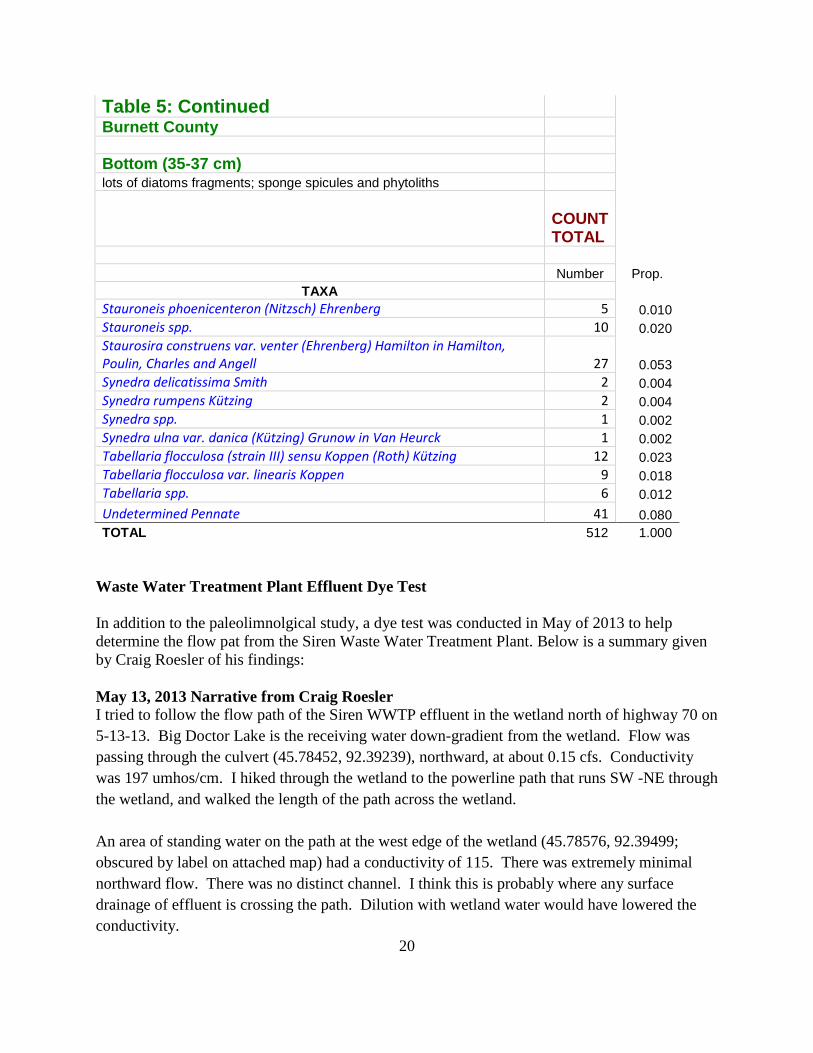
Stauroneis phoenicenteron (Nitzsch) Ehrenberg 5 0.010 Stauroneis spp. 10 0.020 Staurosira construens var. venter (Ehrenberg) Hamilton in Hamilton, Poulin, Charles and Angell 27 0.053 Synedra delicatissima Smith 2 0.004 Synedra rumpens Kützing 2 0.004 Synedra spp. 1 0.002 Synedra ulna var. danica (Kützing) Grunow in Van Heurck 1 0.002 Tabellaria flocculosa (strain III) sensu Koppen (Roth) Kützing 12 0.023 Tabellaria flocculosa var. linearis Koppen 9 0.018 Tabellaria spp. 6 0.012 Undetermined Pennate 41 0.080 TOTAL 512 1.000
Waste Water Treatment Plant Effluent Dye Test In addition to the paleolimnolgical study, a dye test was conducted in May of 2013 to help determine the flow pat from the Siren Waste Water Treatment Plant. Below is a summary given by Craig Roesler of his findings: May 13, 2013 Narrative from Craig Roesler I tried to follow the flow path of the Siren WWTP effluent in the wetland north of highway 70 on 5-13-13. Big Doctor Lake is the receiving water down-gradient from the wetland. Flow was passing through the culvert (45.78452, 92.39239), northward, at about 0.15 cfs. Conductivity was 197 umhos/cm. I hiked through the wetland to the powerline path that runs SW -NE through the wetland, and walked the length of the path across the wetland. An area of standing water on the path at the west edge of the wetland (45.78576, 92.39499; obscured by label on attached map) had a conductivity of 115. There was extremely minimal northward flow. There was no distinct channel. I think this is probably where any surface drainage of effluent is crossing the path. Dilution with wetland water would have lowered the conductivity.

21
I checked a second area of standing water on the trail near the center of the wetland (45.78617, 92.39378). Conductivity at this site was 66, indicating this was wetland derived water. I also found a culvert passing under the trail on the east side of the wetland. There was a slight flow of water northward. Conductivity at this site was 137. This site is separated by upland areas from the large wetland to the west, and cannot be receiving effluent. I think this site receives runoff from road ditches at the west end of Main St. in Siren. There was no flow in these ditches at the time to measure conductivity.
Figure 7: May 13, 2013 Dye & Conductivity Test
It tells us that effluent flow to the lake through the wetland is fairly diffuse and not channelized, so we are probably getting the best treatment the wetland can provide. However, some surface flow is likely to be reaching the lake at times. Also, softwater wetlands, like this one, often do a poor job of long term phosphorus capture. Anaerobic conditions in the wetland soils and underlying groundwater may be allowing phosphorus transport to the lake via groundwater flow. Monitoring wells would be needed to assess this. Watershed
The Clam River Watershed consists of a long narrow strip of land that extends through the center of Burnett County and includes a portion of northeastern Polk County. It is approximately 132,392 acres in size and contains 218 miles of streams and rivers, 5,389 acres of lakes and 24,387 acres of wetlands. The watershed is dominated by forest (51%), grassland

22
(19%) and wetlands (18%), and is ranked medium for nonpoint source issues affecting lakes (WI DNR)
Figure 8: Clam River Watershed (WI DNR)
Figure 9: Clam River Watershed (WI DNR)
23
Watershed Runoff
Land cover plays a critical role in a watershed. The type of land cover that exists in the watershed determines the amount of phosphorus (and sediment) that runs off the land and eventually makes its way to the lake. The actual amount of pollutants (nutrients, sediment, toxins, etc.) depends greatly on how the land within the watershed is used. Vegetated areas, such as forests, grasslands, and meadows, allow the water to permeate the ground and do not produce much surface runoff. On the other hand, agricultural areas, particularly row crops, along with residential/urban areas, minimize infiltration and increase surface runoff. The increased surface runoff associated with these land cover types leads to increased phosphorus and pollutant loading; which, in turn, can lead to nuisance algal blooms, increased sedimentation, overabundant macrophyte populations, and decreased dissolved oxygen levels.(WI DNR) Land that is maintained in a natural, vegetated state is beneficial to soil and water quality.
According to the Wisconsin DNR 2002 State of the St. Croix River Basin report, four key priorities for the basin are identified, all of which are directly associated with water quality:
1. Protection and restoration of shoreland habitat 2. Control of nonpoint source runoff contamination of surface waters 3. Restoration of grasslands, prairies, and wetlands to protect soil and water quality, and to
enhance wildlife habitat 4. Implementation of a Northwest Sands Integrated Ecosystem Management Plan
Below is a list of Land Cover Classifications and percentages for each found in the St. Croix Basin (see St. Croix Basin Land Cover Map), followed by a short discussion of the major land cover types.
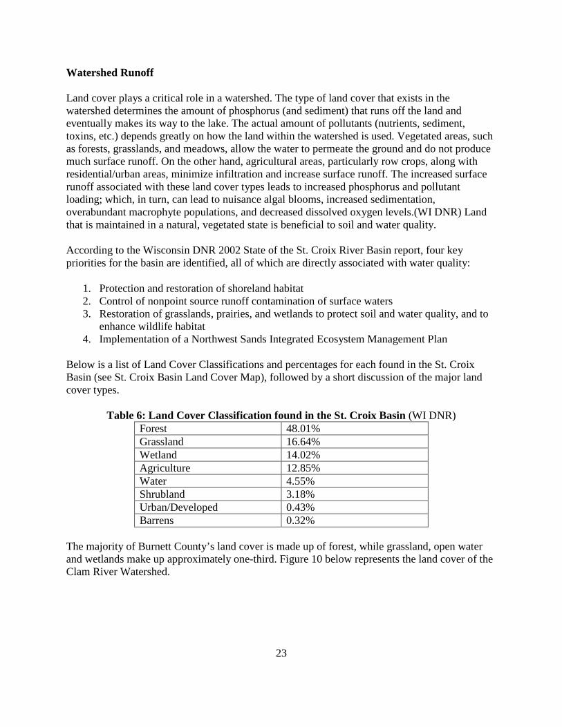
Table 6: Land Cover Classification found in the St. Croix Basin (WI DNR) Forest 48.01% Grassland 16.64% Wetland 14.02% Agriculture 12.85% Water 4.55% Shrubland 3.18% Urban/Developed 0.43% Barrens 0.32%
The majority of Burnett County’s land cover is made up of forest, while grassland, open water and wetlands make up approximately one-third. Figure 10 below represents the land cover of the Clam River Watershed.

24
Figure 10: Clam River Watershed Land Cover
Aquatic Habitats
Functions and Values of Native Aquatic Plants
Naturally occurring native plants are extremely beneficial to the lake. They provide a diversity of habitats, help maintain water quality, sustain fish populations, and support common lakeshore wildlife such as loons and frogs.
Water Quality
Aquatic plants can improve water quality by absorbing phosphorus, nitrogen, and other nutrients from the water that could otherwise fuel nuisance algal growth. Some plants can even filter and break down pollutants. Plant roots and underground stems help to prevent re-suspension of sediments from the lake bottom. Stands of emergent plants (whose stems protrude above the water surface) and floating plants help to blunt wave action and prevent erosion of the shoreline.

25
The shoreline plant populations around Big Doctor Lake are particularly important to reducing erosion along the shoreline, but these populations are also vulnerable to the nutrient loading and the resultant algae growth in the lakes.
Fishing
Habitat created by aquatic plants provides food and shelter for both young and adult fish. Invertebrates living on or beneath plants are a primary food source for many species of fish. Other fish such as bluegills graze directly on the plants themselves. Plant beds, such as bulrush present on Big Doctor Lake, provide important spawning habitat for many fish species.
Waterfowl
Plants offer food, shelter, and nesting material. Birds eat both the invertebrates that live on plants and the plants themselves. During both the late May and July plant surveys, a very diverse population of bird species was observed on and around the lake.
Protection against Invasive Species
Non-native invasive species threaten native plants in Northern Wisconsin. The most common are Eurasian water milfoil (EWM) and curly leaf pondweed (CLP). These species are described as opportunistic invaders. This means that they take over openings in the lake bottom where native plants have been removed. Without competition from other plants, these invasive species may successfully become established in the lake. This concept of opportunistic invasion can also be observed on land, in areas where bare soil is quickly taken over by weeds.
Removal of native vegetation not only diminishes the natural qualities of a lake, but it increases the risk of non-native species invasion and establishment. Invasive species can change many of the natural features of a lake and often lead to expensive annual control plans. Allowing native plants to grow may not guarantee protection against invasive plants, but it can discourage their establishment. Native vegetation may cause localized concerns to some users, but as a natural feature of lakes, they generally do not cause harm.7
Aquatic Invasive Species Status
Reed canary grass (Phalaris arundinacea), and curly leaf pondweed (Potamogeton crispus) have been observed on Big Doctor Lake. No Eurasian water milfoil (Myriophyllum spicatum) was found on the lake, but it has been found in three nearby lakes in Burnett County: Ham Lake, Round Lake and Trade Lake. The EWM has also been found in Long Trade Lake, just across the border in Polk County. It is therefore of paramount importance that the Big Doctor Lake Association takes measures to avoid the introduction of EWM into the lake.

26
Rare and Endangered Species Habitat
According to the Wisconsin Natural Heritage Inventory the following is a list of species on and around Big Doctor Lake that are listed as being endangered, threatened or of special interest (Table 7).
Table 7: Natural Heritage Inventory (NHI) Species Found in Big Doctor Lake Area (T.38N. – R.16W.)
Common Name Scientific Name WI State Status Trumpeter Swan Cygnus buccinator SC/M Bald Eagle Haliaeetus leucocephalus SC/P Diving Beetle Hygrotus sylvanus SC/N Karner Blue Butterfly Lycaeides melissa samuelis NA Pugnose Shiner Notropis anogenus THR Torrey’s Bulrush Scirpus torreyi SC Sand Violet Viola fimbriatula END
WDNR and federal regulations regarding Special Concern species range from full protection to no protection. The current categories and their respective level of protection are as follows:
Key: END = endangered SC/P = fully protected THR = threatened SC/N = no laws regulating use, possession, or harvesting SC = Special Concern SC/H = take regulated by establishment of open /closed seasons SC/FL = Federally protected as endangered or threatened, but not so designated by state SC/M = fully protected by federal and state laws under the Migratory Bird Act Big Doctor Lake Fishery (Jameson, WI DNR) Table 8: BIG DOCTOR LAKE SPECIES LIST Common Name Scientific Name Relative Abundance Gamefish Northern pike Esox lucius Abundant Largemouth Bass Micropterus salmoides Abundant Panfish Bluegill Lepomis macrochirus Abundant Black crappie Pomoxis nigromaculatus Abundant Pumpkinseed Lepomis gibbosus Common Rock bass Amblopites rupestris Common Yellow perch Perca flavecens Common Yellow bullhead Ictalurus natalis Present

27
Table 8: Continued Forage and other species White sucker Catostomus commersoni Common Blackchin shiner Notropis heterodon Present Bluntnose minnow Pimephales notatus Present
Plant Community
METHODS:
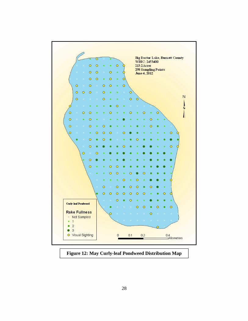
Using a standard formula that takes into account the shoreline shape and distance, islands, water clarity, depth and total lake acres, Michelle Nault (WDNR) generated a sampling grid for Big Doctor Lake (Figure 11). In May, we conducted a Curly-leaf pondweed (CLP) survey to check for the presence of this invasive species. During this survey, we went to each of the 298 points on Big Doctor Lake. We sampled just for Curly-leaf pondweed at each site. This type of survey should result in both detection and approximate mapping of any infestation that may have occurred. During the May survey, we discovered that almost the entire lake was covered with CLP. (See Figure 12)
Figure 11: Big Doctor Lake Sample Grid
28
Figure 12: May Curly-leaf Pondweed Distribution Map
29
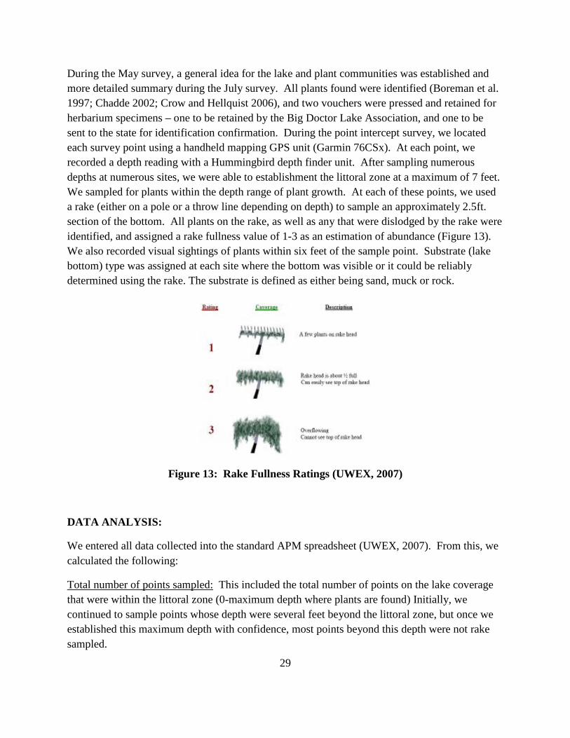
During the May survey, a general idea for the lake and plant communities was established and more detailed summary during the July survey. All plants found were identified (Boreman et al. 1997; Chadde 2002; Crow and Hellquist 2006), and two vouchers were pressed and retained for herbarium specimens – one to be retained by the Big Doctor Lake Association, and one to be sent to the state for identification confirmation. During the point intercept survey, we located each survey point using a handheld mapping GPS unit (Garmin 76CSx). At each point, we recorded a depth reading with a Hummingbird depth finder unit. After sampling numerous depths at numerous sites, we were able to establishment the littoral zone at a maximum of 7 feet. We sampled for plants within the depth range of plant growth. At each of these points, we used a rake (either on a pole or a throw line depending on depth) to sample an approximately 2.5ft. section of the bottom. All plants on the rake, as well as any that were dislodged by the rake were identified, and assigned a rake fullness value of 1-3 as an estimation of abundance (Figure 13). We also recorded visual sightings of plants within six feet of the sample point. Substrate (lake bottom) type was assigned at each site where the bottom was visible or it could be reliably determined using the rake. The substrate is defined as either being sand, muck or rock.
Figure 13: Rake Fullness Ratings (UWEX, 2007)
DATA ANALYSIS:
We entered all data collected into the standard APM spreadsheet (UWEX, 2007). From this, we calculated the following:
Total number of points sampled: This included the total number of points on the lake coverage that were within the littoral zone (0-maximum depth where plants are found) Initially, we continued to sample points whose depth were several feet beyond the littoral zone, but once we established this maximum depth with confidence, most points beyond this depth were not rake sampled.
30
Total number of sites with vegetation: These included all sites where we found vegetation after doing a rake sample. For example, if 20% of all sample sites have vegetation, it suggests that 20% of the lake has plant coverage.
Total number of sites shallower than the maximum depth of plants: This is the number of sites that are in the littoral zone. Because not all sites that are within the littoral zone actually have vegetation, we use this value to estimate how prevalent vegetation is throughout the littoral zone. For example, if 60% of the sites shallower than the maximum depth of plants have vegetation, then we estimate that 60% of the lake’s littoral zone has plants.
Frequency of occurrence: The frequency of all plants (or individual species) is generally reported as a percentage of occurrences at all sample points. It can also be reported as a percentage of occurrences at sample points within the littoral zone.
Frequency of occurrence example: Plant A is sampled at 70 out of 700 total points = 70/700 = .10 = 10% This means that Plant A’s frequency of occurrence = 10% considering the entire lake sample. Plant A is sampled at 70 out of 350 total points in the littoral zone = 70/350 = .20 = 20% This means that Plant A’s frequency of occurrence = 20% when only considering the littoral zone. From these frequencies, we can estimate how common each species was throughout the lake, and how common the species was at depths where plants were able to grow. Note the second value will be greater as not all the points (in this example, only ½) occur at depths shallow enough for plant growth. Simpson’s diversity index: A diversity index allows the entire plant community at one location to be compared to the entire plant community at another location. It also allows the plant community at a single location to be compared over time thus allowing a measure of community degradation or restoration at that site. With Simpson’s diversity index, the index value represents the probability that two individuals (randomly selected) will be different species. The index values range from 0 -1 where 0 indicates that all the plants sampled are the same species to 1 where none of the plants sampled are the same species. The greater the index value, the higher the diversity in a given location. Although many natural variables like lake size, depth, dissolved minerals, water clarity, mean temperature, etc. can affect diversity, in general, a more diverse lake indicates a healthier ecosystem. Perhaps most importantly, plant communities with high diversity also tend to be more resistant to invasion by exotic species.

31
Maximum depth of plants: This indicates the deepest point that vegetation was sampled. In clear lakes, plants may be found at depths of over 20ft, while in stained or turbid locations, they may only be found in a few feet of water. While some species can tolerate very low light conditions, others are only found near the surface. In general, the diversity of the plant community decreases with increased depth.
Number of sites sampled using rope/pole rake: This indicates which rake type was used to take a sample. Protocol suggests a 15ft pole rake, and a 25ft rope rake for sampling (Wagoner personal communication).
Average number of species per site: This value is reported using four different considerations. 1) shallower than maximum depth of plants indicates the average number of plant species at all sites in the littoral zone. 2) vegetative sites only indicate the average number of plants at all sites where plants were found. 3) native species shallower than maximum depth of plants and 4) native species at vegetative sites only excludes exotic species from consideration.
Species richness: This value indicates the number of different plant species found in and directly adjacent to (on the waterline) the lake. Species richness alone only counts those plants found in the rake survey. The other two values include those seen during the point intercept survey and the initial boat survey.
Mean and median depth of plants: The mean depth of plants indicates the average depth in the water column where plants were sampled. Because a few samples in deep water can skew this data, median depth is also calculated. This tells us that half of the plants sampled were in water shallower than this value, and half were in water deeper than this value.
Relative frequency: This value shows a species’ frequency relative to all other species. It is expressed as a percentage, and the total of all species’ relative frequency will add up to 100%. Organizing species from highest to lowest relative frequency value (Table 2) gives us an idea of which species are most important within the macrophyte community.
Relative frequency example:
Suppose that we sample 100 points and found 5 species of plants with the following results: Plant A was located at 70 sites. Its frequency of occurrence is thus 70/100 = 70% Plant B was located at 50 sites. Its frequency of occurrence is thus 50/100 = 50% Plant C was located at 20 sites. Its frequency of occurrence is thus 20/100 = 20% Plant D was located at 10 sites. Its frequency of occurrence is thus 10/100 = 10%
32
To calculate an individual species’ relative frequency, we divide the number of sites a plant is sampled at by the total number of times all plants were sampled. In our example that would be 150 samples (70+50+20+10). Plant A = 70/150 = .4667 or 46.67% Plant B = 50/150 = .3333 or 33.33% Plant C = 20/150 = .1333 or 13.33% Plant D = 10/150 = .0667 or 6.67% This value tells us that 46.67% of all plants sampled were Plant A. Floristic Quality Index (FQI): This index measures the impact of human development on a lake’s aquatic plants. Species in the index are assigned a Coefficient of Conservatism (C) which ranges from 1-10. The higher the value assigned, the more likely the plant is to be negatively impacted by human activities relating to water quality or habitat modifications. Plants with low values are tolerant of human habitat modifications, and often exploit these changes to the point where they may crowd out other species. The FQI is calculated by averaging the conservatism value for each species found in the lake. Consequently, a higher index value indicates a healthier macrophyte community. Nichols (1999) identified four eco-regions in Wisconsin: Northern Lakes and Forests, Northern Central Hardwood Forests, Driftless Area and Southeastern Wisconsin Till Plain. He recommended making comparisons of lakes within ecoregions to determine the target lake’s relative diversity and health. Big Doctor Lake is in the Northern Lakes and Forests Ecoregion.
RESULTS:
Aquatic Plant Survey Results for Big Doctor Lake
An aquatic plant survey was completed for Big Doctor Lake in 2012. Prior to the whole lake monitoring, a curly leaf pondweed (CLP) survey was conducted to confirm the presence of this aquatic invasive species. Since CLP grows earlier than native species, it typically dies in early July; therefore, the CLP survey is done in May or early June while the plant is still robust. A general boat survey was also conducted prior to the point intercept survey to gain familiarity with the lake and the plant species found on the lake. The results discussed below are taken from these two surveys.
Using a standard formula based on a lake’s shoreline shape and distance, islands, water clarity, depth, and size in acres, the Wisconsin Department of Natural Resources (WDNR) generated the sampling point grid of 298 points for Big Doctor Lake. Figure 11 above shows the locations of these sampling points.
33
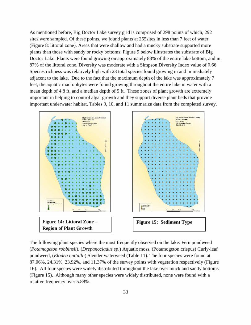
As mentioned before, Big Doctor Lake survey grid is comprised of 298 points of which, 292 sites were sampled. Of these points, we found plants at 255sites in less than 7 feet of water (Figure 8: littoral zone). Areas that were shallow and had a mucky substrate supported more plants than those with sandy or rocky bottoms. Figure 9 below illustrates the substrate of Big Doctor Lake. Plants were found growing on approximately 88% of the entire lake bottom, and in 87% of the littoral zone. Diversity was moderate with a Simpson Diversity Index value of 0.66. Species richness was relatively high with 23 total species found growing in and immediately adjacent to the lake. Due to the fact that the maximum depth of the lake was approximately 7 feet, the aquatic macrophytes were found growing throughout the entire lake in water with a mean depth of 4.8 ft, and a median depth of 5 ft. These zones of plant growth are extremely important in helping to control algal growth and they support diverse plant beds that provide important underwater habitat. Tables 9, 10, and 11 summarize data from the completed survey.
The following plant species where the most frequently observed on the lake: Fern pondweed (Potamogeton robbinsii), (Drepanocladus sp.) Aquatic moss, (Potamogeton crispus) Curly-leaf pondweed, (Elodea nuttallii) Slender waterweed (Table 11). The four species were found at 87.06%, 24.31%, 23.92%, and 11.37% of the survey points with vegetation respectively (Figure 16). All four species were widely distributed throughout the lake over muck and sandy bottoms (Figure 15). Although many other species were widely distributed, none were found with a relative frequency over 5.88%.
Figure 14: Littoral Zone – Region of Plant Growth
Figure 15: Sediment Type

34
Figure 16: Four Most Common Aquatic Plant Species in Big Doctor Lake

35
Curly Leaf Pondweed Survey Results On June 4, 2012, we conducted a point intercept survey for Curly-leaf pondweed. Most of the sites within the littoral zone were discovered to have Curly-leaf pondweed (CLP), an exotic invasive species. Two hundred and thirty one of the two hundred and ninety two points surveyed had CLP. During the full survey in July, we found CLP at several sites, 61 of the 292 points sampled. Below is a map of the July survey which indicates the locations of the known CLP sites (Figure 17) On June 10, 2014 a CLP survey was conducted and the following results are found on Figure 20. Of the 298 points sampled in 2014, only 26 sites were found to have CLP. This is a significant decline from the past years.
During the June and July survey, no Eurasian water-milfoil (Myriophyllum sibiricum) was detected. Several sites adjacent to the littoral zone had Reed canary grass, a common invasive species. We did not find any Purple loosestrife (PLS) in the littoral zone or adjacent to littoral zone; however, PLS had been spotted on a lake nearby. Members of the lake association have been trained in Citizen Lake Monitoring Network aquatic invasive species and have been monitoring the lake. Several members of the Lake Association were trained in 2013 and more
Figure 17: Curly-leaf Pondweed Distribution June and July 2012

36
members will be trained in the future to monitor aquatic invasive species and will continue to survey the lake for purple loosestrife.
Summary of Recommendations: • Preserve and maintain Big Doctor Lake’s diverse native plant community. • Continue to educate lakeshore owners and boaters about the importance of aquatic plants
and the negative impacts AIS can have on the entire lake ecosystem. • Preserve the lake’s many rush/reed/rice beds and the lake’s sensitive habitat areas. • Whenever possible, refrain from removing native plants from the lake. • Reduce and, wherever possible, eliminate fertilizer and pesticide applications near the
lakeshore. • Encourage shoreline restoration. • Establish native vegetation buffer strips along the lakeshore. • Consider transect monitoring for aquatic invasive species at and near the boat landing at
least once a month during the summer months. • Complete a full shoreline inspection in mid-August to locate and eliminate any beds of
Purple loosestrife plants where beetles are not present. • Establish a Clean Boats/Clean Water and Aquatic Invasive Species program. • Conduct Citizen Lake Monitoring for aquatic invasive species from May through
October.
• Consider conducting a study to determine internal loading of phosphorus.

37
Table 9: Big Doctor Lake Aquatic Macrophytes Survey Summary Statistics Summary Statistics
Total number of sites visited 292 Total number of sites with vegetation 255 Total number of sites shallower than maximum depth of plants 292 Frequency of occurrence at sites shallower than maximum depth of plants 87.33 Simpson Diversity Index 0.66 Maximum depth of plants (ft)** 7.00 Number of sites sampled using rake on Rope (R) 292 Number of sites sampled using rake on Pole (P) 0 Average number of all species per site (shallower than max depth) 1.38 Average number of all species per site (veg. sites only) 1.58 Average number of native species per site (shallower than max depth) 1.17 Average number of native species per site (veg. sites only) 1.41 Species Richness 18 Species Richness (including visuals) 23 Mean Depth of Plants (ft) 4.8 Median Depth of Plants (ft) 5 Table 10: Big Doctor Lake FQI Species and Conservatism Values Species Common Name C Brasenia schreberi Watershield 6 Chara Muskgrasses 7 Elatine minima Waterwort 9 Eleocharis acicularis Needle spikerush 5 Elodea nuttallii Slender waterweed 7 Isoetes sp. Quillwort 8 Lemna minor Small duckweed 4 Nitella Nitella 7 Nuphar variegata Spatterdock 6 Nymphaea odorata White water lily 6 Potamogeton epihydrus Ribbon-leaf pondweed 8 Potamogeton pulcher Spotted pondweed 10 Potamogeton pusillus Small pondweed 7 Potamogeton robbinsii Fern pondweed 8 Utricularia gibba Creeping bladderwort 9 Vallisneria americana Wild celery 6 Number of Plants 16 mean C 7.0625 FQI 28.25

38
We identified a total of 22 native species in Big Doctor Lake, of which, 16 species were used to calculate the Coefficient of Covservation. They produced a mean Coefficient of Conservation 7.06 and a Floristic Index of 28.25 (Table 11). Nichols (1999) reported an Average mean C for the Northern Lakes and Forest Region of 6.7 putting Big Doctor Lake slightly above average for this part of the state. However, the FQI was higher than the mean FQI of 24.3 for the Northern Lakes and Forest Region (Nichols 1999). The high FQI is a result of Big Doctor Lake’s above average plant diversity and the fact that there are several species of plants in the lake with high Coefficient of Conservation values.
39
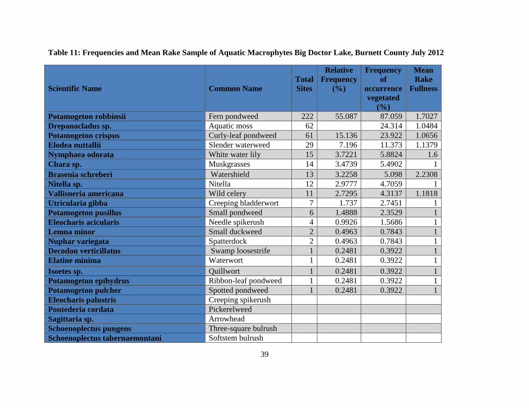
Table 11: Frequencies and Mean Rake Sample of Aquatic Macrophytes Big Doctor Lake, Burnett County July 2012
Scientific Name
Common Name
Total Sites
Relative Frequency
(%)
Frequency of
occurrence vegetated
(%)
Mean Rake
Fullness
Potamogeton robbinsii Fern pondweed 222 55.087 87.059 1.7027 Drepanocladus sp. Aquatic moss 62 24.314 1.0484 Potamogeton crispus Curly-leaf pondweed 61 15.136 23.922 1.0656 Elodea nuttallii Slender waterweed 29 7.196 11.373 1.1379 Nymphaea odorata White water lily 15 3.7221 5.8824 1.6 Chara sp. Muskgrasses 14 3.4739 5.4902 1 Brasenia schreberi Watershield 13 3.2258 5.098 2.2308 Nitella sp. Nitella 12 2.9777 4.7059 1 Vallisneria americana Wild celery 11 2.7295 4.3137 1.1818 Utricularia gibba Creeping bladderwort 7 1.737 2.7451 1 Potamogeton pusillus Small pondweed 6 1.4888 2.3529 1 Eleocharis acicularis Needle spikerush 4 0.9926 1.5686 1 Lemna minor Small duckweed 2 0.4963 0.7843 1 Nuphar variegata Spatterdock 2 0.4963 0.7843 1 Decodon verticillatus Swamp loosestrife 1 0.2481 0.3922 1 Elatine minima Waterwort 1 0.2481 0.3922 1 Isoetes sp. Quillwort 1 0.2481 0.3922 1 Potamogeton epihydrus Ribbon-leaf pondweed 1 0.2481 0.3922 1 Potamogeton pulcher Spotted pondweed 1 0.2481 0.3922 1 Eleocharis palustris Creeping spikerush Pontederia cordata Pickerelweed Sagittaria sp. Arrowhead Schoenoplectus pungens Three-square bulrush Schoenoplectus tabernaemontani Softstem bulrush

40
Aquatic Plant Management
This section reviews the potential management methods available, and reports recent management activities on the lakes. The application, location, timing, and combination of techniques must be considered carefully.
Discussion of Management Methods
Permitting Requirements
The Department of Natural Resources regulates the removal of aquatic plants when chemicals are used, when plants are removed mechanically, and when plants are removed manually from an area greater than thirty feet in width along the shore. The requirements for chemical plant removal are described in Administrative Rule NR 107 – Aquatic Plant Management. A permit is required for any aquatic chemical application in Wisconsin. Additional requirements exist when a lake is considered an ASNRI (Area of Special Natural Resource Interest) due, in the case of Big Doctor Lake, to the presence of wild rice.
The requirements for manual and mechanical plant removal are described in NR 109 – Aquatic Plants: Introduction, Manual Removal & Mechanical Control Regulations. A permit is required for manual and mechanical removal except for when a riparian (waterfront) landowner manually removes or gives permission to someone to manually remove plants, (with the exception of wild rice) from his/her shoreline up to a 30-foot corridor. A riparian landowner may also manually remove the invasive plants Eurasian water milfoil, curly leaf pondweed, and purple loosestrife along his or her shoreline without a permit. Manual removal refers to the control of aquatic plants by hand or hand–held devices without the use or aid of external or auxiliary power (WDNR).
Manual Removal
Manual removal—hand pulling, cutting, or raking—will effectively remove plants from small areas. It is likely that plant removal will need to be repeated more than once during the growing season. The best timing for hand removal of herbaceous plant species is after flowering but before seed head production. For plants with rhizomatous (underground stem) growth, pulling roots is not generally recommended since it may stimulate new shoot production. Hand pulling is a strategy recommended for rapid response to a Eurasian water milfoil establishment and for private landowners who wish to remove small areas of curly leaf pondweed growth. Raking is recommended to clear nuisance growth in riparian area corridors up to twenty feet wide.
SCUBA divers may engage in manual removal for invasive species like Eurasian water milfoil. Care must be taken to ensure that all plant fragments are removed from the lake. Manual removal with divers is recommended for shallow areas with sporadic EWM growth.
41
Mechanical Control
Larger-scale control efforts require more mechanization. Mechanical cutting, mechanical harvesting, diver-operated suction harvesting, and rotovating (tilling) are the most common forms of mechanical control available. WDNR permits under Chapter NR 109 are required for mechanical plant removal. (APIS, Army Corps of Engineers)
Aquatic plant harvesters are floating machines that cut and remove vegetation from the water. The cutter head uses sickles similar to those found on farm equipment, and generally cut to depths from one to six feet. A conveyor belt on the cutter head brings the clippings onboard the machine for storage. Once full, the harvester travels to shore to discharge the load of weeds off of the vessel.
The size, and consequently the harvesting capabilities, of these machines vary greatly. As they move, harvesters cut a swath of aquatic plants that is between 4 and 20 feet wide, and can be up to 10 feet deep. The on-board storage capacity of a harvester ranges from 100 to 1000 cubic feet (by volume) or 1 to 8 tons (by weight).
In some cases the plants are transported to shore by the harvester itself for disposal, while in other cases a barge is used to store and transport the plants in order to increase the efficiency of the cutting process. The plants are deposited on shore, where they can be transported to a local farm (the nutrient content of composted aquatic plants is comparable to that of cow manure) or to an upland landfill for proper disposal. Most harvesters can cut between 2 and 8 acres of aquatic vegetation per day, and the average lifetime of a mechanical harvester is 10 years.
Mechanical harvesting of aquatic plants presents both positive and negative consequences to any lake. Its results—open water and accessible boat lanes—are immediate, and can be enjoyed without the restrictions on lake use which follow herbicide treatments. In addition to the human use benefits, the clearing of thick aquatic plant beds may also increase the growth and survival of some fish. By eliminating the upper canopy, harvesting reduces the shading caused by aquatic plants. The nutrients stored in the plants are also removed from the lake, and the sedimentation that would normally occur as a result of the decaying of this plant matter is prevented. Additionally, repeated treatments may result in thinner, more scattered growth.
Aside from the obvious effort and expense of harvesting aquatic plants, there are many environmentally-detrimental consequences to consider. The removal of aquatic species during harvesting is non-selective. Native and invasive species alike are removed from the target area. This loss of plants results in a subsequent loss of the functions they perform, including sediment stabilization and wave absorption. Shoreline erosion may therefore increase. Other organisms such as fish, reptiles, and insects are often displaced or removed from the lake in the harvesting process. This may have adverse effects on these organisms’ populations as well as the lake ecosystem as a whole.
42
While the enjoyed results of harvesting aquatic plants may be short term, the negative consequences are not so short lived. Much like mowing a lawn, harvesting must be conducted numerous times throughout the growing season. Although the harvester collects most of the plants that it cuts, some plant fragments inevitably persist in the water. This may allow the invasive plant species to propagate and colonize in new, previously unaffected areas of the lake. Harvesting may also result in re-suspension of contaminated sediments and the excess nutrients they contain.
Disposal sites are a key component when considering the mechanical harvesting of aquatic plants. The sites must be on shore and upland to make sure the plants and their reproductive structures don’t make their way back into the lake or to other lakes. The number of available disposal sites and their distance from the targeted harvesting areas will determine the efficiency of the operation, in terms of time as well as cost.
Timing is also important. The ideal time to harvest, in order to maximize the efficiency of the harvester, is just before the aquatic plants break the surface of the lake. For curly leaf pondweed, it should also be before the plants form turions to avoid spreading of the turions within the lake. If the harvesting is conducted too early, the plants will not be close enough to the surface, and the cutting will not do much damage to them. If too late, there may be too much plant matter on the surface of the lake for the harvester to cut effectively.
If the harvesting work is contracted, be sure to inspect the equipment before and after it enters the lake. Since these machines travel from lake to lake, they may carry plant fragments with them, and facilitate the spread of aquatic invasive species from one body of water to another. One must also consider prevailing winds, since cut vegetation can be blown into open areas of the lake or along shorelines.
Diver dredging operations use pump systems to collect plant and root biomass. The pumps are mounted on a barge or pontoon boat. The dredge hoses are from 3 to 5 inches in diameter and are handled by one diver. The hoses normally extend about 50 feet in front of the vessel. Diver dredging is especially effective against the pioneering establishment of submersed invasive plant species. When a weed is discovered in a pioneering state, this methodology can be considered. To be effective, the entire plant, including the subsurface portions, should be removed.
Plant fragments can result from this type of operation, but fragmentation is not as great a problem when infestations are small. Diver dredging operations may need to be repeated more than once to be effective. When applied to a pioneering infestation, control can be complete. However, periodic inspections of the lake should be performed to ensure that all the plants have been found and collected.
Lake substrates play an important part in the effectiveness of a diver dredging operation. Soft substrates are very easy to work in. Divers can remove the plant and root crowns with little

43
difficulty. Hard substrates, however, pose more of a problem. Divers may need hand tools to help dig the root crowns out of hardened sediment.
Rotovation involves using large underwater rototillers to remove plant roots and other plant tissue. Rotovators can reach bottom sediments to depths of 20 feet. Rotovating may significantly affect non-target organisms and water quality as bottom sediments are disturbed. However, the suspended sediments and resulting turbidity produced by rotovation settles fairly rapidly once the tiller has passed. Tilling contaminated sediments could possibly release toxins into the water column. If there is any potential of contaminated sediments in the area, further investigation should be performed to determine the potential impacts from this type of treatment. Tillers do not operate effectively in areas with many underwater obstructions such as trees and stumps. If operations are releasing large amounts of plant material, harvesting equipment should be on hand to collect this material and transport it to shore for disposal.
Biological Control
Biological control is the purposeful introduction of parasites, predators, and/or pathogenic microorganisms to reduce or suppress populations of plant or animal pests. Biological control counteracts the problems that occur when a species is introduced into a new region of the world without a complex or assemblage of organisms that feed directly upon it, attack its seeds or progeny through predation or parasitism, or cause severe or debilitating diseases. With the introduction of native pests to the target invasive organism, the exotic invasive species may be maintained at lower densities.
Weevils
Weevils have potential for use as a biological control agent against Eurasian water milfoil. There are several documented “natural” declines of EWM infestations. In these cases, EWM was not eliminated but its abundance was reduced enough so that it did not achieve dominance. These declines are attributed to an ample population of native milfoil weevils (Euhrychiopsis lecontei). Weevils feed on native milfoils but will shift preference over to EWM when it is present. Lakes where weevils can become an effective control have an abundance of native Northern water milfoil and fairly extensive natural shoreline where the weevils can over winter. Because native milfoils are susceptible to higher doses of herbicides, any control strategy for EWM that would also harm native milfoil may hinder the ability of this natural bio-control agent. Lakes with large bluegill populations are not good candidates for weevils because bluegills feed on the weevils. The presence and efficacy of stocking weevils in EWM lakes is being evaluated in Wisconsin lakes. So far, stocking does not appear to be effective.

44
The effectiveness of biocontrol efforts varies widely (Madsen, 2000). Beetles are commonly used to control Purple loosestrife populations in Wisconsin with good success. As mentioned above, weevils are used as an experimental control for Eurasian water milfoil once the plant is established. Tilapia and carp are used to control the growth of filamentous algae in ponds. Grass carp, an herbivorous fish, is sometimes used to feed on pest plant populations, but grass carp introduction is not allowed in Wisconsin.
There are advantages and disadvantages to the use of biological control as part of an overall aquatic plant management program. Advantages include longer-term control relative to other technologies, lower overall costs, and plant-specific control. On the other hand there are several disadvantages to consider, including very long control times (years instead of weeks), a lack of available agents for particular target species, and relatively specific environmental conditions necessary for success.
Biological control is not without risks; new non-native species introduced to control a pest population may cause problems of its own. Biological control is not currently proposed for management of aquatic plants in Big Doctor Lake, although it will be considered for purple loosestrife control should an infestation arise.
Re-vegetation with Native Plants
Another aspect to biological control is native aquatic plant restoration. The rationale for re-vegetation is that restoring a native plant community should be the end goal of most aquatic plant management programs (Nichols 1991; Smart and Doyle 1995). However, in communities that have only recently been invaded by nonnative species, a propagule (seed) bank probably exists that will restore the community after nonnative plants are controlled (Madsen, Getsinger, and Turner, 1994). Re-vegetation following plant removal is probably not necessary on Big Doctor Lakes because a healthy, diverse native plant population is present.
Physical Control
In physical management, the environment of the plants is manipulated, which in turn acts upon the plants. Several physical techniques are commonly used: dredging, drawdown, benthic (lake bottom) barriers, and shading or light attenuation. Because they involve placing a structure on the bed of a lake and/or affect lake water level, a Chapter 30 or 31 DNR permit would be required.
Dredging removes accumulated bottom sediments that support plant growth. Dredging is usually not performed solely for aquatic plant management but to restore lakes that have been filled in with sediments, have excess nutrients, need deepening, or require removal of toxic substances (Peterson 1982). Lakes that are very shallow due to sedimentation tend to have excess plant growth. Dredging can form an area of the lake too deep for plants to grow, thus creating an area

45
for open water use (Nichols 1984). By opening more diverse habitats and creating depth gradients, dredging may also create more diversity in the plant community (Nichols 1984). Results of dredging can be very long term. However, due to the cost, environmental impacts, and the problem of disposal, dredging should not be performed for aquatic plant management alone. It is best used as a lake remediation technique. Dredging is not suggested for the Big Doctor Lake as part of the aquatic plant management plan.
Benthic barriers or other bottom-covering approaches are another physical management technique. The basic idea is to cover the plants with a layer of a growth-inhibiting substance. Many materials have been used, including sheets or screens of organic, inorganic, and synthetic materials; sediments such as dredge sediment, sand, silt or clay; fly ash; and various combinations of the above materials (Cooke 1980b; Nichols 1974; Perkins 1984; Truelson 1984). The problem with using sediments is that new plants establish on top of the added layer (Engel and Nichols 1984). The problem with synthetic sheeting is that the gasses evolved from plant and sediment decomposition collect underneath and lift the barrier (Gunnison and Barko 1992). Benthic barriers will typically kill the plants under them within 1 to 2 months, after which time they may be removed (Engel 1984). Sheet color is relatively unimportant; opaque (particularly black) barriers work best, but even clear plastic barriers will work effectively (Carter et al. 1994). Sites from which barriers are removed will be rapidly re-colonized (Eichler et al. 1995). Synthetic barriers, if left in place for multi-year control, will eventually become sediment-covered and will allow colonization by plants. Benthic barriers may be best suited to small, high-intensity use areas such as docks, boat launch areas, and swimming areas. However, they are too expensive to use over widespread areas, and heavily affect benthic communities by removing fish and invertebrate habitat. A WDNR permit would be required for a benthic barrier.
Shading or light attenuation reduces the light plants need to grow. Shading has been achieved by fertilization to produce algal growth, by application of natural or synthetic dyes, shading fabric, or covers, and by establishing shade trees (Dawson 1981, 1986; Dawson and Hallows 1983; Dawson and Kern-Hansen 1978; Jorga et al. 1982; Martin and Martin 1992; Nichols 1974). During natural or cultural eutrophication, algae growth alone can shade aquatic plants (Jones et al. 1983). Although light manipulation techniques may be useful for narrow streams or small ponds, in general these techniques are of only limited applicability. Physical control is not currently proposed for management of aquatic plants in Big Doctor Lake.
Herbicide and Algaecide Treatments
Herbicides are chemicals used to kill plant tissue. Currently, no product can be labeled for aquatic use if it poses more than a one in a million chance of causing significant damage to human health, the environment, or wildlife resources. In addition, it may not show evidence of biomagnification, bioavailability, or persistence in the environment (Joyce, 1991). Thus, there

46
are a limited number of active ingredients that are assured to be safe for aquatic use (Madsen, 2000).
An important caveat is that these products are considered safe when used according to the label. The U.S. Environmental Protection Agency (EPA)-approved label gives guidelines protecting the health of the environment, the humans using that environment, and the applicators of the herbicide. WDNR permits under Chapter NR 107 are required for herbicide application.
General descriptions of herbicide classes are included below.
Contact herbicides
Contact herbicides act quickly and are generally lethal to all plant cells that they contact. Because of this rapid action, or other physiological reasons, they do not move extensively within the plant and are effective only where they contact plants directly. They are generally more effective on annuals (plants that complete their life cycle in a single year). Perennial plants (plants that persist from year to year) can be defoliated by contact herbicides, but they quickly resprout from unaffected plant parts. Submersed aquatic plants that are in contact with sufficient concentrations of the herbicide in the water for long enough periods of time are affected, but regrowth occurs from unaffected plant parts, especially plant parts that are protected beneath the sediment. Because the entire plant is not killed by contact herbicides, retreatment is necessary, sometimes two or three times per year. Endothall, diquat, and copper are contact aquatic herbicides.
Systemic herbicides
Systemic herbicides are absorbed into the living portion of the plant and move within the plant. Different systemic herbicides are absorbed to varying degrees by different plant parts. Systemic herbicides that are absorbed by plant roots are referred to as soil active herbicides and those that are absorbed by leaves are referred to as foliar active herbicides. 2,4-D, dichlobenil, fluridone, and glyphosate are systemic aquatic herbicides. When applied correctly, systemic herbicides act slowly in comparison to contact herbicides. They must move to the part of the plant where their site of action is. Systemic herbicides are generally more effective for controlling perennial and woody plants than contact herbicides. Systemic herbicides also generally have more selectivity than contact herbicides.
Broad spectrum herbicides
Broad spectrum (sometimes referred to as nonselective) herbicides are those that are used to control all or most species of vegetation. This type of herbicide is often used for total vegetation control in areas such as equipment yards and substations where bare ground is preferred. Glyphosate is an example of a broad spectrum aquatic herbicide. Diquat, endothall, and

47
fluridone are used as broad spectrum aquatic herbicides, but can also be used selectively under certain circumstances.
Selective herbicides
Selective herbicides are those that are used to control certain plants but not others. Herbicide selectivity is based upon the relative susceptibility or response of a plant to an herbicide. Many related physical and biological factors can contribute to a plant's susceptibility to an herbicide. Physical factors that contribute to selectivity include herbicide placement, formulation, timing, and rate of application. Biological factors that affect herbicide selectivity include physiological factors, morphological factors, and stage of plant growth.
Environmental considerations
Aquatic communities consist of aquatic plants including macrophytes (large plants) and phytoplankton (free floating algae), invertebrate animals (such as insects and clams), fish, birds, and mammals (such as muskrats and otters). All of these organisms are interrelated in the community. Organisms in the community require a certain set of physical and chemical conditions to exist such as nutrient requirements, oxygen, light, and space. Aquatic weed control operations can affect one or more of the organisms in the community, and in turn affect other organisms or weed control operations. These operations can also impact water chemistry which may result in further implications for aquatic organisms.
Copper
Copper is a naturally occurring element that is essential at low concentrations for plant growth. It does not break down in the environment, but it forms insoluble compounds with other elements and is bound to charged particles in the water. It rapidly disappears from water after application as an herbicide. Because it is not broken down, it can accumulate in bottom sediments after repeated or high rates of application. Accumulation rarely reaches levels that are toxic to organisms or significantly above background concentrations in the sediment.
2,4-D
2,4-D photodegrades on leaf surfaces after being applied to leaves, and is broken down by microbial degradation in water and in sediments. Complete decomposition usually takes about 3 weeks in water but can be as short as 1 week. 2,4-D breaks down into naturally occurring compounds.
Diquat
When applied to enclosed ponds for submersed weed control, diquat is rarely found longer than 10 days after application and is often below detection levels 3 days after application. The most

48
important reason for the rapid disappearance of diquat from water is that it is rapidly taken up by aquatic vegetation and bound tightly to particles in the water and bottom sediments. When bound to certain types of clay particles, diquat is not biologically available. When diquat is bound to organic matter, it can be slowly degraded by microorganisms. When diquat is applied foliarly, it is degraded to some extent on the leaf surfaces by photodegradation. Because it is bound in the plant tissue, a proportion is probably degraded by microorganisms as the plant tissue decays.
Endothall
Like 2,4-D, endothall is rapidly and completely broken down into naturally occurring compounds by microorganisms. The by-products of endothall dissipation are carbon dioxide and water. Complete breakdown usually occurs in about 2 weeks in water and 1 week in bottom sediments.
Fluridone
Dissipation of fluridone from water occurs mainly by photodegradation. Metabolism by tolerant organisms and microbial breakdown also occurs, and microbial breakdown is probably the most important method of breakdown in bottom sediments. The rate of breakdown of fluridone is variable and may be related to time of application. Applications made in the fall or winter, when the sun's rays are less direct and days are shorter, result in longer half-lives. Fluridone usually disappears from pondwater after about 3 months but can remain up to 9 months. It may remain in bottom sediment between 4 months and 1 year.
Glyphosate
Glyphosate is not applied directly to water for weed control, but when it does enter the water it is bound tightly to dissolved and suspended particles and to bottom sediments and becomes inactive. Glyphosate is broken down into carbon dioxide, water, nitrogen, and phosphorus over a period of several months.
Copper Compounds
Copper-based compounds are generally used to treat filamentous algae. Common chemicals used are copper sulfate and Cutrine Plus, a chelated copper algaecide.
Herbicide Use to Manage Invasive Species
Eurasian water milfoil
The Army Corps of Engineers Aquatic Plant Information System (APIS) identifies the following herbicides for control of Eurasian water milfoil: 2,4-D, diquat, endothall, All of these herbicides with the exception of diquat are available in both granular and liquid formulations. It is possible to target invasive species by using the appropriate herbicide and timing. The herbicide 2,4-D is

49
most commonly used to treat EWM in Wisconsin. This herbicide kills dicots including native aquatic species such as northern water milfoil, coontail, water lilies, spatterdock, and watershield. Early season (April to May) treatment of Eurasian water milfoil is recommended to limit the impact on native aquatic plant populations because EWM tends to grow before native aquatic plants.
Granular herbicide formulations are more expensive than liquid formulations (per active ingredient). However, granular formulations release the active ingredient over a longer period of time. Granular formulations, therefore, may be more suited to situations where herbicide exposure time will likely be limited, as is the case in small bands or blocks. In large, shallow lakes with widespread EWM, a whole lake treatment with a low rate of liquid herbicide may be most cost effective because exposure time is greater. Factors that affect exposure time are size and configuration of treatment area, water flow, and wind.
Application rates for liquid and granular formulations are not interchangeable. A rate of 1 to 1.5 mg/L 2,4-D applied as a liquid is a middle rate that will require a contact time of 36 to 48 hours. Application rates recommended for Navigate (granular 2,4-D) are 100 pounds per acre for depths of 0 to 5 feet, 150 pounds per acre for 5 to 10 feet, and 200 pounds per acre for depths greater than 10 feet.
Curly leaf pondweed
The Army Corps of Engineers Aquatic Plant Information System (APIS) identifies three herbicides for control of curly leaf pondweed: diquat, endothall, and fluridone. Fluridone requires exposure of 30 to 60 days making it infeasible to target a discreet area in a lake system. The other herbicides act more rapidly. Herbicide labels provide water use restriction following treatment. Diquat (Reward) has the following use restrictions: drinking water 1-3 days, swimming and fish consumption 0 days. Endothall (Aquathol K) has the following use restrictions: drinking water 7 – 25 days, swimming 0 days, fish consumption 3 days.
Studies have demonstrated that curly leaf pondweed can be controlled with Aquathol K (a formulation of endothall) in 50 to 60 degree F water, and that treatments of CLP this early in its life cycle can prevent turion formation (APIS). Since curly leaf pondweed is actively growing at these low water temperatures and many native aquatic plants are still dormant, early season treatment selectively targets curly leaf pondweed. Staff from the Minnesota Department of Natural Resources and the U.S Army Engineer Research and Development Center is conducting trials of this method.
Because the dosage is at lower rates than the dosage recommended on the label, a greater herbicide residence time is necessary. To prevent drift of herbicide and allow greater contact time, application in shallow bays is likely to be most effective. Herbicide applied to a narrow

50
band of vegetation along the shoreline is likely to drift, rapidly decrease in concentration, and be rendered ineffective.
Burnett County Land and Water Conservation (LWCD)
Burnett County assists the Big Doctor Lake Association in management of aquatic invasive species. They have individuals available to assist with the following tasks:
• Conduct watercraft inspection at public access points.
• Complete in-lake monitoring for Eurasian Water Milfoil (EWM) and other invasive species.
• Carry out public outreach and education events related to invasive species including lake meetings, fishing tournaments, county fairs, and local festivals.
• Post signs at boat landings and other public lake access points to inform residents of the new Burnett County “do not transport” ordinance.
• Train local lake residents and others to monitor their own boat landings as part of the WDNR Clean Boats, Clean Waters (CBCW) program.
• Train lake residents and others in Citizen Lake Monitoring, which includes CBCW, Secchi, Water Chemistry, and Aquatic Invasive Species identification.
• Assist in “rapid response” actions to identify and respond to new invasive species infestations reported by the public.
• Conduct integrated pest management for purple loosestrife control including beetle rearing and release, and offer assistance with clipping and herbicide application for individual infestations.
In-lake monitoring focuses on searching for potential establishment of Eurasian water milfoil and other aquatic invasive species at boat landings and other areas with high public use. Grab samples are taken at regular intervals at these high public use areas and at random locations around the littoral zone. All Burnett County boat landings are monitored each year.
Workshops and trainings include Clean Boats, Clean Waters training, plant identification, and whole lake monitoring workshops. Staff generally travels to local lakes to encourage participation and provide more focused training.

51
The Rapid Response Plans will involve a team of resource professionals from various agencies who can directly assist the lake organization in managing newly discovered invasive species and develop a plan to restore the native plant community. This Rapid Response team will assist with identifying appropriate management methods, coordinating and, in some instances, carrying out control measures, grant writing, and completing or hiring consultants to complete aquatic plant surveys and management plans. Plan Goals and Strategies Overall Purpose This section of the plan lists goals for aquatic plant management for Big Doctor Lakes. It also presents a detailed strategy of actions that will be used to reach Aquatic Plant Management Plan goals. Educational strategies that outline audience, messages, and methods are included under each goal. Plan Goals The APM committee established six goals and prioritized them in the following order:
1. Maintain and improve water quality conditions. 2. Identify and educate the Big Doctor Lake community regarding aquatic plant
management, management strategies found in the plan and appropriate plant management actions.
3. Prevent the introduction and spread of aquatic invasive species. 4. Reduce and control the population of curly leaf pondweed 5. Enhance and maintain the diverse populations of native aquatic plants. 6. Create and maintain navigable channels for fishing and boating.
Goal 1: Maintain and improve water quality conditions. Objectives
A. Continue to sample and record both water samples and Secchi readings to ensure water quality.
B. Encourage lake residents to restore and preserve shoreline buffers of native vegetation.
Messages 1. Shoreline buffers protect water quality and provide fish and wildlife habitat.
Describe ways to restore shoreline buffers (natural recovery, stop mowing, and plant natives).
2. Cost sharing for restoration shoreline buffers is available from Burnett County. 3. Describe the Burnett County shoreline buffer requirements and how to report
violations of these requirements. 4. Highlight good examples of shoreline buffers on private waterfront property.
52
C. Reduce phosphorus and sediment loads from immediate watershed.
D. Encourage Riparian land owners to adopt and implement storm water runoff controls for
existing structures and all new constructions. Adaptive Management Approach Big Doctor Lake has a relatively small watershed draining to it and as a result, the impacts that are most controllable at this time originate along the lake’s immediate shoreline. These sources include faulty septic systems, the use of phosphorus-containing fertilizers, shoreland areas that are maintained in an unnatural manner, and impervious surfaces. To reduce these impacts, the Big Doctor Lake Association will conduct an educational initiative aimed at raising awareness among shoreland property owners concerning their impacts on the lake. This will include news letter articles and guest speakers at Association meetings. This Management Action will be completed in conjunction with the Shoreland Restoration Action listed below. Action Steps:
1. Recruit facilitators 2. Facilitators summarize educational material collected from WDNR, UW-Extension, and County Land and Water Conservation sources for the creation of informative materials 3. Facilitators disperse materials to stakeholders
Actions:
1. Continue to monitor water quality through WDNR Citizens Lake Monitoring Network advanced water chemistry program and Secchi disk sampling and record data in the Surface Water Integrated Monitoring System (SWIMS) system. (OBJ A)
2. Incorporate the Adaptive Management Approach to reduce phosphorus and sediment
loads from immediate watershed. (OBJ B, C)
3. Educate and assist Big Doctor Lake community members in the restoration and preservation of shoreland buffers and shoreland vegetation. Continue implementation of shoreline owners’ education program. (OBJ B, C, D)
Goal 2: Educate the Big Doctor Lake community regarding aquatic plant management,
management strategies found in the plan and appropriate plant management actions.
Audience: Big Doctor Lake Community
A. All lake residents B. Business owners C. Lake users D. Residents who treated waterfront with herbicides in the past
53
Messages
1. Summary of APM plan, notice of public meeting, and how to get full APM plan 2. List of APM dos and don’ts 3. Contact list for APM include web resources 4. Native aquatic plant values 5. Limit impacts to native aquatic plants by traveling with no wake in shallow areas,
using hand removal methods near docks and swimming areas, etc. 6. Explain procedure for individual corridor herbicide applications and describe
conditions where herbicide treatment may be allowed. 7. Explain location and procedures for curly leaf pondweed herbicide treatment 8. Identification of CLP and methods for removal (include illustrations) 9. Identification of PL and methods for removal (include illustrations) 10. Identification of EWM and contact if suspected (include illustrations) 11. Locations of nearby lakes with EWM 12. Describe new potential invasive species and why they are a threat 13. Native plant identification 14. Inspect, clean, and drain boats and equipment. 15. Burnett County has an ordinance that makes it illegal to transport aquatic plants
on public roads. Methods Summary of APM plan AIS education workshops for all lake users Improvements to signage at boat landings Updates to AIS handouts Newsletter articles Mailings to lake residents Update Facebook site Clean Boats, Clean Waters monitoring/education Annual meeting/special meetings Door-to-door distribution of information Plastic peel-off stickers for boats Method Audience Message APM plan summary
A - D 1
AIS workshops
A – C 4, 8-15
Signage
A – C 14, 15
AIS handouts
A – D 4, 6-15
Newsletter articles
A – B 1–15

54
Mailings
A – B 1 –15
Facebook site updates
A – D 1 -15
Clean Boats, Clean Waters
C 8-11, 14, 15
Annual and special meetings
A – B 1-15
Door-to-door distribution
A 4-15
Plastic peel-off stickers
A – C 14, 15
Goal 3: Prevent the introduction and spread of aquatic invasive species Objectives A. 100% of boaters inspect, clean, and drain boats, trailers and equipment.
B. 100% enforcement of Burnett County’s Do Not Transport Ordinance.
C. Big Doctor Lake is monitored regularly for AIS introduction.
D. Big Doctor Lake Association is ready to rapidly respond to identified AIS in the lakes and river.
E. Enhance the reputation of the Big Doctor Lake community as being proactive and
robust as it relates to aquatic plant management strategies and enforcements. Actions
1. Conduct Clean Boats Clean Waters monitoring and education at the boat landing using paid and/or volunteer staff. (OBJ A,C)
2. Work with the Burnett County Sheriff’s Department to encourage increased
enforcement and potentially increased fines for the Do Not Transport Ordinance. (OBJ B, E)
3. Monitor boat landings and other areas with high potential for introduction of AIS.
(OBJ A, E)
4. Train volunteer monitors to identify and monitor for aquatic invasive species through the University of Wisconsin Extension Citizen Lake Monitoring Network Aquatic

55
Invasive Species program. (Burnett County Land and Water Conservation Department will train volunteers with support from BDLA.) (OBJ C, E)
5. Review and update the existing rapid response plan for Eurasian water milfoil found
in Appendix D. (OBJ D) Goal 4: Reduce the growth of and control the population of curly leaf pondweed. Objectives
A. Monitor the growth of curly leaf pondweed.
B. Implement control efforts to reduce the population of Curly-leaf pondweed by at least 10% based on the 2012 baseline mapping data.
Actions
1. Provide information to the Big Doctor Lake community so they can identify Curly-leaf pondweed (CLP) and they know who to contact if they have a suspected plant. (Burnett County LWCD will provide volunteer training for plant identification. Burnett County AIS coordinator and lake association AIS representative will provide identification assistance.) (OBJ B)
2. Map all beds of curly leaf pondweed (CLP) on the lake every other year. (OBJ A)
3. Consider CLP control efforts using early season chemical treatment or other accepted
methods, if CLP spreads to an unacceptable level. (OBJ B) Goal 5: Enhance and maintain the diverse populations of native aquatic plants. Objectives
A. Implement strict adherence with treatment standards and monitoring methods prior to and following herbicide treatment.
B. Prevent removal of native plants using herbicides.
C. Educate and communicate to the community members of Big Doctor Lake the
role and importance of aquatic plants and their impacts on them. Discussion The plant community in the Big Doctor Lake is diverse and extensive. It is important to understand that these plants play a very important role in the lake ecosystem. Aquatic plants in the lake provide habitat for a diverse fish population. They also provide protection from

56
shoreline erosion. Removing native plants could lead to adverse effects in the lakes such as but not limited to the increase in the algal populations. Healthy native plant populations prevent colonization by invasive plants. Erosion and runoff from waterfront property may alter sediment characteristics encouraging spread of invasive plants. Boating disturbance near the shoreline can remove aquatic plants and the valuable functions they provide. Boating disturbance near shore also creates sediment disturbance and the release of excess phosphorus, which can lead to access algal blooms. Actions
1. Consider alternative methods for removing native plants, other than using herbicide treatment, for individual access corridors. Encourage hand removal as a viable method of helping control nuisance species. (OBJ B)
2. Conduct a point intercept survey of the lake every five to ten years, or as needed.
(OBJ C)
3. Update the aquatic plant management plan every five to ten years, or as needed. (OBJ A, B and C)
Educational activities are detailed in the discussion for Goal 5. Goal 6: Create and maintain navigable channels for fishing and boating. Objectives
A. Allow individual riparian landowners the right to maintain navigation channels through dense beds of curly leaf pondweed on Big Doctor Lake.
B. All herbicide treatments are conducted legally. Permits are required for aquatic
application of herbicides in Wisconsin. Action
1. Follow all Wisconsin DNR requirements for obtaining permits for the herbicide treatment for individual access corridors. (See Appendix F for specific details of management options for aquatic plants)
2. Hand removal methods will be recommended for navigation impairment created by
native plants. Information about individual access corridors The only time a permit is not required to control aquatic plants is when a waterfront property owner manually removes (i.e. hand-pulls or rakes), or gives permission to someone to manually remove plants (except wild rice) from his/her shoreline in an area that is 30 feet or less in width along the shore and is not within a Designated Sensitive Area. The non-native invasive plants (Eurasian watermilfoil, curlyleaf pondweed, and purple loosestrife) may be manually removed

57
beyond 30 feet without a permit, as long as native plants are not harmed. Wild rice removal always requires a permit. The state is required to consult with Great Lakes Indian Fish and Wildlife Commission prior to any removal of wild rice. Individual Access Corridors are the openings from a waterfront property owner’s shoreline out into the lake. These corridors may be a maximum of thirty feet wide.
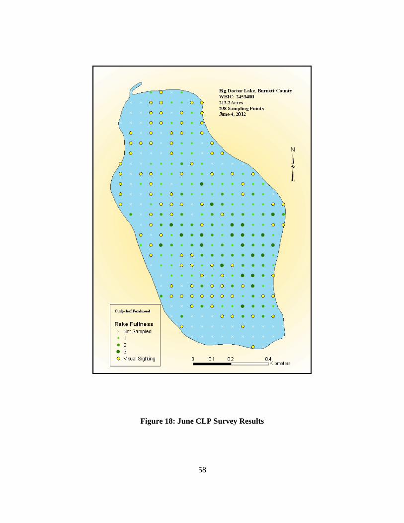
58
Figure 18: June CLP Survey Results

59
Figure 19: July CLP Survey Results

60
Figure 20: CLP Survey June 10, 2014
Procedure for Individual Corridor Permitting and Monitoring Document nuisance conditions (landowner/contractor provide in permit application in February/March)
Indicate when plants cause problems and how long problems persist Include dated photos of nuisance conditions from previous season (or
location relative to curly leaf pondweed bed map) List depth at end of dock Provide examples of specific activities that are limited because of presence
of nuisance aquatic plants

61
Describe practical alternatives to herbicide use that were considered. These might include:
• Hand removal/raking of aquatic plants • Extending dock to greater depth • Altering the route to and from the dock • Use of another type of watercraft or motor i.e., is the type of
watercraft used common to other sites with similar conditions on this lake?
Spraying for curly leaf pondweed may occur along the entire length of a waterfront property owner’s shoreline. Spraying areas with wild rice will not be permitted.
Aquatic herbicide applicator to provide this information in permit application based on information from the landowner.
• Verify/refute nuisance conditions/navigation impairment
Landowners will document conditions with photographs and submit request for treatment to WDNR.
For curly leaf pondweed treatment, verification must occur the year before treatment in May or June. Once CLP nuisance is verified and a permit is approved, additional verification is not needed for three subsequent years (although permit applications must be completed each year).
Treatment for CLP must occur with water temperatures from 50 - 58 degrees F.
WDNR will contact herbicide applicator and owner with a notice to proceed with treatment.

62
Table 12: Implementation Plan
Action Items Timeline Cost 2013 Cost 2014 Cost 2015 Responsible Parties
Prevent AIS Introduction Identify and organize volunteer workers/employers for CBCW program 20 hours 15 hours 15 hours
BDLA Executive Board
Conduct CBCW program ongoing 10 hours 10 hours 10 hours BDLA President Increase enforcement of BC Do Not Transport Ordinance ongoing 10 hours 10 hours 10 hours BDLA President
Monitor boat landings Ongoing 100-125 hours
100-125 hours
100-125 hours
BDLA, BC Sheriff Dept. and LWCD
Train Volunteer monitors in CLMN Annually $0 $0 $0 BDLA, Burnett County LWCD
Rapid Response plan review As needed $0 $0 $0 Burnett County LWCD
Ongoing 3 hours 3 hours 3 hours
BDLA, Burnett County LWCD
AIS Reduction and Prevention Provide Identification information and
encourage volunteer monitoring 20 hours 15 hours 15 hours BDLA Executive Board
Monitor Lake for PL growth May - August 20 hours 20 hours 20 hours
BDLA AIS Committee, BC LWCD
Cut and Spray plants as needed July/August 20 hours 20 hours 20 hours BDLA/community Map all CLP beds Mid June $600 BC LWCD Consider if CLP control is warranted September TBD BDLA Pre & Post Mapping of CLP TBD TBD BC LWCD Preserve Native Plants Conduct a point intercept survey of the lake 2017-2022 $4000 BDLA Update APM plan 2018-2023 $4000 BDLA

63
Action Items Timeline Cost 2013 Cost 2014 Cost 2015 Responsible Parties
Water Quality Water chemistry and Secchi sampling ongoing 30 hours 30 hours 30 hours BDLA Reduce phosphorus and sediment loads from immediate watershed Ongoing TBD BDLA, BC LWCD Educate and assist Big Doctor Lake community members in the restoration and preservation of shoreland buffers and shoreland vegetation Ongoing TBD BDLA, BC LWCD Continue implementation of shoreline owners’ education program Ongoing TBD BDLA, BC LWCD Educate Big Doctor Lake Community AIS workshops Ongoing $0 $0 $0 BC LWCD AIS signage As needed $0 $0 $0 BC LWCD Additional AIS signage
$500 $100 $100 BDLA
BDLA emails and Social Media Ongoing 40 hours 40 hours 40 hours BDLA BDLA Facebook updates Ongoing 30 hours 30 hours 30 hours BDLA Annual and special meetings Ongoing $200 $200 $200 BDLA
Maintain Navigable Channels Individual Riparian Owners estimate the need
for navigable channels Mid June
Riparian Land Owners (RLO)
Develop a Request for Proposal (RFP) for CLP treatment and select applicator as needed January
RLO
Apply for permits February $270 4 hours
$270 4 hours
$270 4 hours
RLO WDNR
Conduct treatment Late May Authorized Applicator
Monitor for effectiveness of treatment Late June Riparian Land Owners
Provide information to guide individual corridor treatment permits January
4 hours Vol BDLA, BC LWCD
Encourage hand removal methods of individual corridor clearing
January & April-June RLO
A-1
Appendix A: Big Doctor Lake Survey Results BIG DOCTOR LAKE USER SURVEY SECTION 1 – Residency These first few questions will help to determine who is responding to this survey and how those people would like to use Big Doctor Lake. If you have more than one property on the lake, please comment on the one property that you have had the longest. 1. What type of property do you have on Big Doctor Lake? If you have more than one type of property, please report on only the property you have had the longest. (please select one) ___ permanent residence ___ business ___ seasonal residence ___ undeveloped land ___ weekend visitors ___ other __________________________________________ 2. How long have you owned your property on Big Doctor Lake? (If less than 1 year, please write ‘1’ in the space provided. If you own multiple properties, please comment on the one you have owned or rented for the longest period of time.) I have owned the property for ___ year(s). 3. During a 12-month period (Jan. 1 – Dec. 31) how many days are you, members of your family, or guests at the property indicated in Question 1? (please provide your best estimate in the space below) There are people at the property approximately ________ days a year. 4. On average, about how many people are at the property each time it is being used? ________________ SECTION 2 – Lake Use The purpose of this section is to gather information on how Big Doctor Lake is used by its residents. 1. From the list below, check all activities on Big Doctor Lake that you, your family, or guests participate in. ___ A. fishing from the shore ___ F. ice fishing ___ K. wildlife viewing ___ B. fishing from a boat ___ G. speed boating ___ L. canoe/kayak/paddle boat ___ C. pontoon boating ___ H. jet skiing ___ M. water skiing/tubing ___ D. rest/relaxation ___ I. wild rice harvest ___ N. other (please list) ________________ ___ E. swimming/wading ___ J.sailing______________________________

A-2
2. Which 3 activities from the above list do you or members of your family or guests participate in most often? (write the letters of the corresponding activities in the spaces below) I (We) participate in ___ most often, ___ second most often, and ___ third most often. 3. During the open-water (no ice) season, how frequently do you use the lake for the activities listed in Question 1, this section? ___ daily ___ once or twice per month ___several times per week ___once or twice per open-water season ___ 3 or 4 times per month 4. What type(s) of watercraft do you own, rent, or use on Big Doctor Lake? (Check all that apply. If you do not use any watercraft on Big Doctor Lake, please check the last box.) ___ motorized boat (0-50hp) ___ canoe or kayak ___ motorized boat (greater than 50hp) ___ sailboat ___ paddle boat ___ other (please specify) _________________ ___ pontoon boat ___ I do not own, rent, or use a boat or other personal watercraft – PWC (jet-ski) on Big Doctor Lake SECTION 3 – Lake Stewardship This section of the survey will provide information about the lake stewardship practices of lake property owners and renters. 1. Which of the following do you consider the most desirable shoreline for your property? (please check one) ___ mowed/manicured lawn to shoreline ___ managed natural vegetation along shoreline ___ mowed lawn with landscaped shoreline ___ unmanaged natural vegetation along shoreline ___ mowed lawn to sand beach ___ other (please describe) __________________ 2. Which of the following water quality/landscaping practices are you familiar with? (check all that apply) ___ rain garden ___natural shoreline restoration ___ shoreline buffers ___ septic system upgrade ___ native prairie restoration ___ runoff reduction practices ___ not fertilizing ___ native flower/tree planting ___ using zero phosphorus fertilizers ___ other (please describe) _______________ ___ diversion of surface water runoff away from the lake ___ not familiar with any of these

A-3
3. Which, if any, of the following water quality/landscaping practices have you installed on your property on Big Doctor Lake? (check all that apply) ___ rain garden ___natural shoreline restoration ___ shoreline buffers ___ septic system upgrade ___ native prairie restoration ___ runoff reduction practices ___ not fertilizing ___ native flower/tree planting ___ using zero phosphorus fertilizers ___ other (please describe) _______________ ___ diversion of surface water runoff away from the lake ___ I have not installed any of the above water quality/landscaping practices. 4. Which, if any, of the following outcomes do you consider a motivator to install a water quality/landscaping practice on your property? (check all that apply) ___ increasing the natural beauty of your property ___ improving the water quality of Big Doctor Lake ___ improving the water quality around your property’s shoreline ___ providing better habitat for fish ___ providing better habitat for birds and wildlife ___ setting an example for other lake residents ___ less lawn mowing time ___ a property tax rebate ___ financial assistance that pays a portion of the cost/installation ___ technical assistance that would evaluate my property for water quality concerns ___ technical assistance that would identify appropriate practices to install ___ other (please describe) ____________________________________________________ ___ I have no interest in installing a water quality/landscaping practice on my property 5. What type of septic system do you have on your property? (select all that apply) ___ mound system ___ holding tank ___ other (please list) ______________ ___ at-grade system ___ lift pump system ________________________________ ___ conventional system ___ none (skip to Section 4) 6. How many years ago was your septic system last inspected? (please provide your best recall) ___ 1-5 years ___ 6-10 years ___ 11+ years ___ Never ___ Not Sure 7. When was your septic system last ‘pumped’ or ‘sewered’? (please provide your best recall) ___ 1-5 years ___ 6-10 years ___ 11+ years ___ Never ___ Not Sure
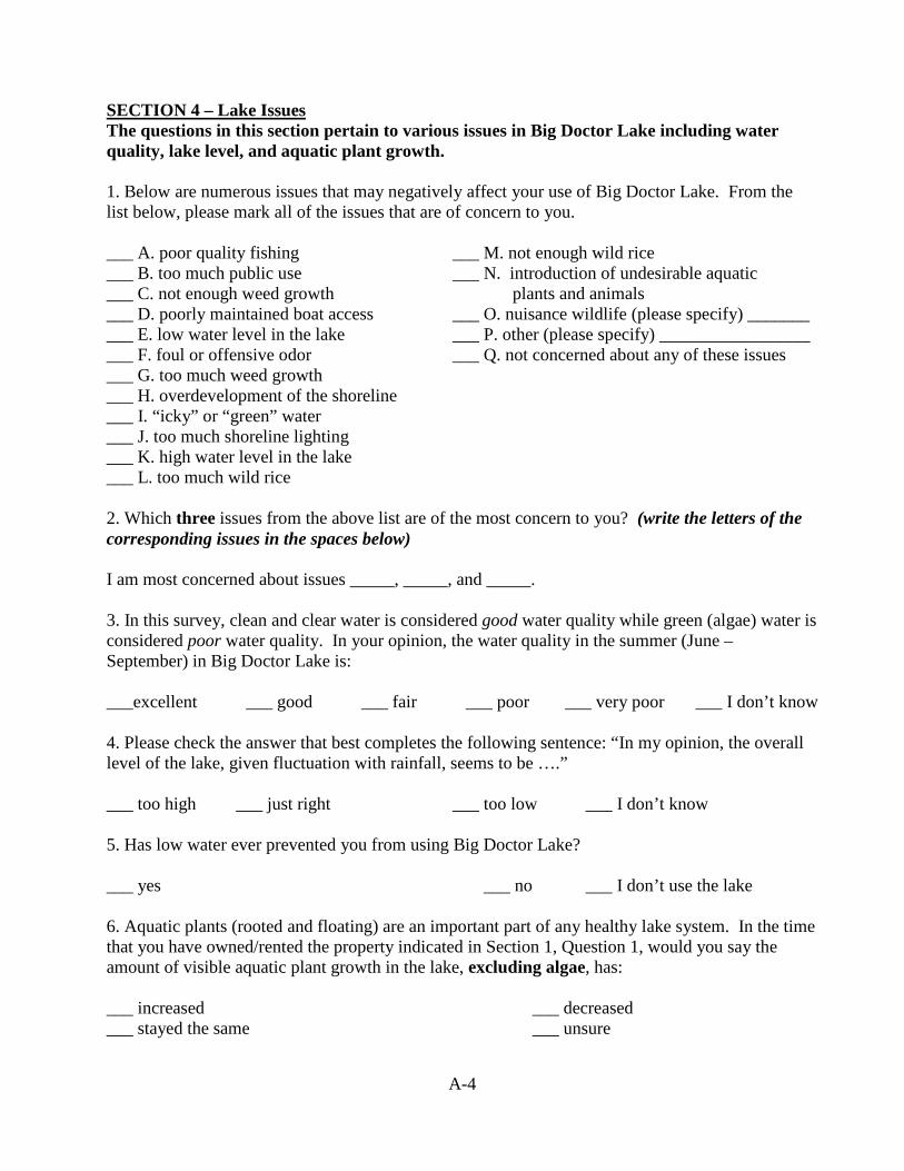
A-4
SECTION 4 – Lake Issues The questions in this section pertain to various issues in Big Doctor Lake including water quality, lake level, and aquatic plant growth. 1. Below are numerous issues that may negatively affect your use of Big Doctor Lake. From the list below, please mark all of the issues that are of concern to you. ___ A. poor quality fishing ___ M. not enough wild rice ___ B. too much public use ___ N. introduction of undesirable aquatic ___ C. not enough weed growth plants and animals ___ D. poorly maintained boat access ___ O. nuisance wildlife (please specify) _______ ___ E. low water level in the lake ___ P. other (please specify) _________________ ___ F. foul or offensive odor ___ Q. not concerned about any of these issues ___ G. too much weed growth ___ H. overdevelopment of the shoreline ___ I. “icky” or “green” water ___ J. too much shoreline lighting ___ K. high water level in the lake ___ L. too much wild rice 2. Which three issues from the above list are of the most concern to you? (write the letters of the corresponding issues in the spaces below) I am most concerned about issues _____, _____, and _____. 3. In this survey, clean and clear water is considered good water quality while green (algae) water is considered poor water quality. In your opinion, the water quality in the summer (June – September) in Big Doctor Lake is: ___excellent ___ good ___ fair ___ poor ___ very poor ___ I don’t know 4. Please check the answer that best completes the following sentence: “In my opinion, the overall level of the lake, given fluctuation with rainfall, seems to be ….” ___ too high ___ just right ___ too low ___ I don’t know 5. Has low water ever prevented you from using Big Doctor Lake? ___ yes ___ no ___ I don’t use the lake 6. Aquatic plants (rooted and floating) are an important part of any healthy lake system. In the time that you have owned/rented the property indicated in Section 1, Question 1, would you say the amount of visible aquatic plant growth in the lake, excluding algae, has: ___ increased ___ decreased ___ stayed the same ___ unsure

A-5
7. Aquatic plant growth varies throughout the open water season. Which month(s) of the season do you consider aquatic plant growth, excluding algae, to be problematic in Big Doctor Lake? (check all that apply) ___ May ___ June ___ July ___ August ___September ___ October ___ It is never a problem ___ I don’t know SECTION 5 – Aquatic Invasive Species in Big Doctor Lake This section of the survey seeks to determine how much lake residents know about aquatic invasive species. Aquatic invasive species are plants and animals that are foreign to Big Doctor Lake and do not belong there. Curly-leaf pondweed (CLP) Curly-leaf pondweed has not been documented in Big Doctor Lake but could be a threat in the future. CLP can create nuisance levels of plant growth and negatively impact water quality in a lake. 1. How much do you know about CLP and the problems it can cause in a lake? ___ a lot ___ some ___ very little ___ just what I have read here 2. Do you think you would recognize CLP in the lake if you saw it? ___ definitely yes ___ probably yes ___ unsure ___ probably not ___ definitely not Eurasian Watermilfoil (EWM) Eurasian watermilfoil has not been documented in Big Doctor Lake but could be a threat in the future. EWM can form dense beds of vegetation that interfere with many lake uses. 3. How much do you know about EWM and the problems it can cause in a lake? ___ a lot ___ some ___ very little ___ just what I have read here 4. Do you think you would recognize EWM in the lake if you saw it? ___ definitely yes ___ probably yes ___ unsure ___ probably not ___ definitely not Purple Loosestrife Purple loosestrife, an invasive shoreline/wetland plant species, has not been documented in Big Doctor Lake but could be a threat in the future. Purple loosestrife can take over shorelines and wetlands displacing more beneficial native plants. 5. How much do you know about purple loosestrife and the problems it can cause in a lake? ___ a lot ___ some ___ very little ___ just what I have read here 6. Do you think you would recognize purple loosestrife in the lake if you saw it?

A-6
___ definitely yes ___ probably yes ___ unsure ___ probably not ___ definitely not Other Aquatic Invasive Species 7. Below is a list of additional aquatic invasive species. Please check all of those that you have heard of before. ___ zebra mussels ___ rusty crayfish ___ spiny waterflea ___ Chinese mystery snail ___ banded mystery snail ___ hydrilla ___ New Zealand mudsnail ___ freshwater jellyfish ___ phragmites (giant
reed grass) ___ Japanese knotweed ___ carp ___I have not heard of any of these 8. In order to gauge potential interest, would you be willing to take part in a training session to help you identify aquatic invasive species in the lake? ___ definitely yes ___ probably yes ___ unsure ___ probably not ___ definitely not SECTION 6 – Aquatic Plant Management Currently aquatic plant growth in Big Doctor Lake is not managed. Algae growth is also not managed. A benefit of aquatic plant management strategies is that they can also help reduce algae growth. Aquatic plants in a lake can be managed in many different ways. Sometimes no aquatic plant management may be the best option. 1. Do you think that management of aquatic plants in Big Doctor Lake is necessary? ___ definitely yes ___ probably yes ___ unsure ___ probably not ___ definitely not (skip to Question 3) (skip to Question 3) (skip to Question 3) 2. Which type(s) of aquatic plants do you think should be managed on Big Doctor Lake? (check all that apply) ___ grow below the water’s surface ___ float on the surface of the water ___ stick out of the water ___ grow on the shoreline, out of the water ___ other (please explain) _________________________________________________________ Common Aquatic Plant Management Methods If plant management is recommended for Big Doctor Lake, what methods might you support? Please assume that the following management methods are safe and legal, and would only be performed by professionals and only be used if approved by the State of Wisconsin. Total removal or eradication of aquatic plants is not possible.

A-7
3. Please mark whether you would support, oppose, or need more information about the use of these aquatic plant management methods on Big Doctor Lake. Small-scale (less than 10 acres) mechanical harvesting: ___ Support ___ Oppose ___ Need more information Large-scale (10 acres or greater) mechanical harvesting: ___ Support ___ Oppose ___ Need more information Hand-pulling and raking in shallow waters: ___ Support ___ Oppose ___ Need more information Small-scale (less than 10 acres) of chemical herbicide application: ___ Support ___ Oppose ___ Need more information Large-scale (greater than 10 acres) of chemical herbicide application: ___ Support ___ Oppose ___ Need more information Biological control (using one live species to control another): ___ Support ___ Oppose ___ Need more information No Management: ___ Support ___ Oppose ___ Need more information 4. Have you made any attempts to remove or control aquatic plants in Big Doctor Lake by your shore property? (check one) ___ no (skip to Section 7) ___ yes, I did it myself ___ yes, I hired someone ___ yes, I did some myself and I hired someone 5. What have you done to remove aquatic plants from the lake by your property? (Check all that apply) ___ hire someone to hand-pull or rake ___ self hand pull or rake ___ hire someone to apply chemical herbicide ___ self-application of chemical herbicide ___ mechanical plant removal with boat and motor or other apparatus ___ other (please specify)___________________________________________________________ SECTION 7 –Community Support Local, county, state, and federal resources will be sought in addition to Lake Association funds to implement management recommendations for Big Doctor Lake. Donations of volunteer time, services, materials, and equipment can be used as match funding for many grant programs reducing the overall financial burden to the Lake Association. The following questions will help to determine your willingness to support future projects involving the implementation of aquatic plant and lake management recommendations.

A-8
1. Following are activities that lake residents could participate in. Please check all those activities you might be willing to volunteer your time if additional assistance is needed. This is not a commitment but rather a measure of possible assistance if needed. ___ watercraft inspection at the boat landings ___ on the water monitoring for aquatic invasive species ___ shore land monitoring for aquatic invasive species ___ raising beetles for purple loosestrife control ___ native aquatic plant monitoring and identification ___ water quality monitoring ___ wildlife monitoring (ex. frogs, turtles, loons, other waterfowl, mussels & clams) ___ I am not interested in volunteering any time (skip to question 3) 2. How much time would you be willing to contribute to support any of the activities in Question 1 above? ___ a few hours a year ___ a few days a year ___ longer periods of time 3. Donated service needs are varied and somewhat unknown, but could include any of the options listed below. Do you think you would be willing to provide any of the services that may be necessary? This is not a commitment but rather a measure of possible assistance if needed. (check all that apply) ___ GPS use ___ graphic design ___ web development ___ grant writing ___ legal services ___ scuba diving ___ printing services ___ construction services ___ outdoor sign design ___ physical labor ___ gardening/landscaping design ___ sewing ___ gardening/landscaping implementation ___ other (please specify) _________ ___I am not interested or not able to provide assistance 4. Have you ever attended a Big Doctor Lake Association (BDLA) meeting? ___ yes (skip to Question 6) ___ no 5. If you answered “no” in Question 4, why haven’t you attended a BDLA meeting? ___not interested ___I don’t have time ___I never know when they are occurring ___other (please explain)_______________________________________ 6. The Big Doctor Lake Association annual meeting is generally held in the morning on the Saturday of Memorial Day Weekend. In the following list of meeting dates and times, please check up to three meeting dates that would work for you. ___ The current date and time works for me ___ Hold the meeting in the afternoon on the Saturday of Memorial Day ___ Hold the meeting in the evening on the Saturday of Memorial Day ___ Hold the meeting the Saturday before Memorial Weekend ___ Hold the meeting the Saturday after Memorial Weekend

A-9
___ Hold the meeting a different day (please indicate when) ____________________________________ ___ I am not interested in the Big Doctor Lake Association annual meeting 7. What is your affiliation with the Big Doctor Lake Association? ___ current member (skip to Question 9) ___ former member ___ I’ve never been a member 8. If you are not a member of the BDLA, please indicate why. (check all that apply) ___ not interested ___ I disagree with what they are doing ___ dues are too high ___ I haven’t been asked to be a member ___ I did not know it existed ___ I feel there is no benefit for being a member ___ I do not have enough time ___ Other _______________________________ 9. How satisfied are you with the following aspects of Lake Association activity?
Very Somewhat Somewhat Very Satisfied Satisfied Unsure Dissatisfied Dissatisfied Communication with community Meeting frequency Meeting atmosphere (parliamentary procedure) Executing Lake Association business Promoting cooperation to achieve goals and objectives Management of Association finances Listening to property owners’ needs and concerns 10. How would you prefer to be contacted by the BDLA? (please check one) ___ mail ___ email ___ phone ___ in person ___ I do not want to be contacted 11. If there are any additional issues you would like the Lake Association to address, please use the space below to explain. _______________________________________________________________________________________________________________________________________________________________________________________________________________________________________________________________

A-10
Thank you for your time and your answers! Providing your contact information is OPTIONAL but if you wish to, please do! Contact information will be used for follow up if needed. Name: ________________________________________________________________________ Address: ____________________________________City______________ State___ Zip ______ Phone number: _________________ Email address ______________________________ ______
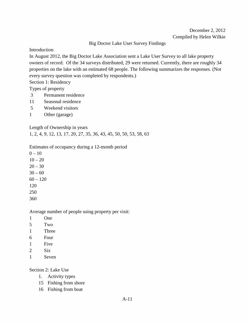
A-11
December 2, 2012 Compiled by Helen Wilkie
Big Doctor Lake User Survey Findings Introduction In August 2012, the Big Doctor Lake Association sent a Lake User Survey to all lake property owners of record. Of the 34 surveys distributed, 29 were returned. Currently, there are roughly 34 properties on the lake with an estimated 68 people. The following summarizes the responses. (Not every survey question was completed by respondents.) Section 1: Residency Types of property 3 Permanent residence 11 Seasonal residence 5 Weekend visitors 1 Other (garage) Length of Ownership in years 1, 2, 4, 9, 12, 13, 17, 20, 27, 35, 36, 43, 45, 50, 50, 53, 58, 63 Estimates of occupancy during a 12-month period 0 – 10 10 – 20 20 – 30 30 – 60 60 – 120 120 250 360 Average number of people using property per visit: 1 One 5 Two 1 Three 6 Four 1 Five 2 Six 1 Seven Section 2: Lake Use
1. Activity types 15 Fishing from shore 16 Fishing from boat

A-12
16 Pontoon 16 Rest/relaxation 17 Swimming/wading 7 Ice fishing 5 Speed boating 3 Jet skiing 0 Wild rice harvest 2 Sailing 16 Wildlife viewing 14 Canoe/kayak/paddle boat 10 Water skiing/tubing 1 Other (annual youth trash pickup; snowmobile, ice skating)
2. Most frequent activities
1 Fishing from shore 8 Fishing from boat 7 Pontoon boat 9 Rest/relax 13 Swim
2 Ice fish 1 Speed boat 0 Jet Ski 1 Wild Rice 2 Sailing 5 Wild Life Viewing 6 Canoe/kayak 3 Skiing/Tubing 1 Other – winter sports
3. Activity frequency
3 Daily 4. Several times per week 5. 3 or 4 times per month 6. Once or twice per month
4. Watercraft types
12 Motorized (0-50 hp) 3 Motorized (greater than 50 hp) 9 Paddle boat 14 Pontoon boat 3 Personal watercraft PWC (jet-ski) 14 Canoe or kayak

A-13
3 Sailboat 2 Other (rowboat)
Section 3: Lake Stewardship Shoreline desirability
1 Mowed/manicured lawn to shoreline 2 Mowed lawn with landscaped shoreline 2 Mowed lawn to sand beach 12 Managed natural vegetation along shoreline 3 Unmanaged natural vegetation along shoreline Knowledge of water quality/landscaping practices 9 Rain garden 10 shoreline buffers 10 Native prairie restoration 15 Not fertilizing 12 Using zero phosphorus fertilizers 7 Diversion of surface water runoff away from the lake 7 Natural shoreline restoration 8 Septic system upgrade 8 Runoff reduction practices 8 Native flower/tree planning Implemented water quality/landscaping practices 9 Shoreline buffers 16 Not fertilizing 8 Using zero phosphorus fertilizers 2 Diversion of surface water runoff away from the lake 5 Natural shoreline restoration 6 Septic system upgrade 2 Runoff reduction practices 7 Native flower/tree planting 1 Other (Rip rock) 1 I have not installed any of the above water quality/landscaping practices Incentives or water quality/landscaping practices 9 Increasing natural beauty 20 Improving water quality 9 Improving water quality around property shoreline 12 Providing better habitat for fish 12 Providing better habitat for birds & wildlife

A-14
8 Setting an example for other lake residents 3 Less lawn mowing time 8 Property tax rebate 7 Financial assistance that pays a portion of the cost/installation 5 Technical assistance to evaluate property for water quality 7 Technical assistance to id appropriate installment practices
5. What type of septic system do you have on your property 8 Mound 8 Holding tank 1 At-grade 1 Lift pump 1 Conventional 2 Other (drain field)
6. How many years ago was your septic system last inspected
14 One to five years 2 Six to 10 years 1 11 plus years 2 Not sure
7. Time since septic system was pumped/sewered
13 One to five years 1 Six to 10 1 11 plus 2 Never 1 Not sure
Section 4: Lake Issue 1. Lake issues that negatively affect lake use Section 5: Aquatic Invasive Species in Big Doctor Lake 1. Lake issues that negatively affect lake use Section 6: Aquatic Plant Management 1. Do you think management of aquatic plants is necessary?
13 Definitely yes 5 Probably yes 4 Unsure 2 Probably not
2. Preferred types of aquatic plants do you think should be managed?

A-15
12 Grow below the water’s surface 10 Stick out of the water 13 Float on the surface of the water 6 Grow on the shoreline, of out of the water
Common Aquatic Plant Management Methods 3. Mechanical harvesting small scale (less than 10 acres)
9 Support 2 Oppose 8 Need more information
4. Mechanical harvesting large scale (10 acres or more) 8 Support 1 Oppose 9 Need more information
5. Hand pulling in shallow water 16 Support 1 Oppose 2 Need more information
6. Herbicide applications small scale (less than 10 acres) 7 Support 4 Oppose 9 Need more information
7. Herbicide applications large scale (more than 10 acres) 6 Support 6 Oppose 9 Need more information
8. Biological control (1 live species controls another) 10 Support 1 Oppose 7 Need more information
9. No management 1 Support 9 Oppose 6 Need more information
Section 7: Community Support 1. Activities that lake residents might be willing to volunteer time to assist
3 Watercraft inspection at boat landing 11 On the water monitoring for aquatic invasive species 11 Shore land monitoring for aquatic invasive species 2 Raising beetles for purple loosestrife control 4 Native aquatic plant monitoring and identification 11 Water quality monitoring

A-16
5 Wildlife monitoring (frogs, turtles, loons, other waterfowl, mussels & clams) 1 I am not interested in volunteering any time
2. How much time would you be willing to contribute to support any of the activities in question 1
above?
5 A few hours a year 10 A few days a year 2 Longer periods of time
3. Donated service needs are varied and somewhat unknown, but could include….do you think
you would be willing to provide any of the services that may be necessary? 3 GPS Use 0 Graphic design 1 Web development 3 Grant writing /editing 0 Legal services 1 Scuba diving 0 Printing Services 3 Construction services 1 Outdoor sign design 11 Physical labor 3 Gardening/landscape design 0 Other 2 Sewing 4 Gardening/landscape implementation 4. Have you ever attended a Big Doctor Lake Association (BDLA) meeting?
16 Yes 3 No 5. If you answered “no” in question 4, why haven’t you attended a BDLA meeting
0 Not interested 0 I don’t have time 1 Never know when occurring 3 Other “scheduling hasn’t worked”

C-1
Appendix B Aquatic Macrophyte Maps of Big Doctor Lake

C-2

C-3

C-4
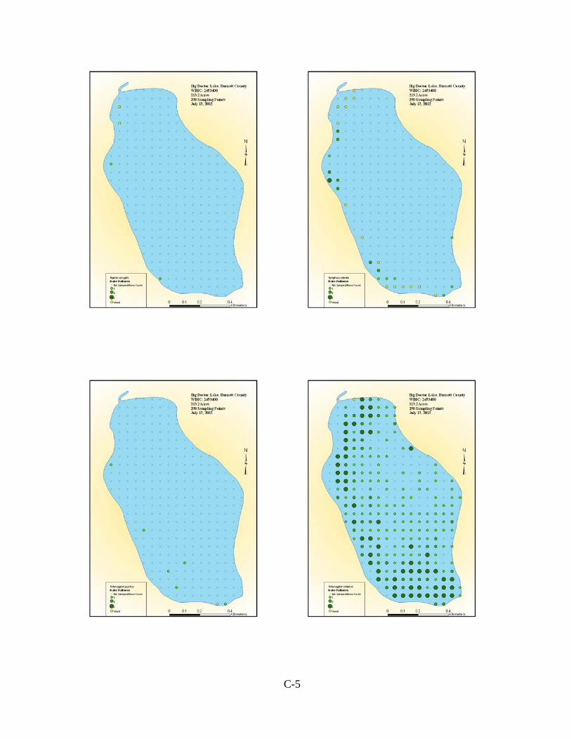
C-5

C-6

C-7

C-8

C-1
Appendix C
Rapid Response for Early Detection of Eurasian Water Milfoil
1. The Bid Doctor Lake Association (BDLA)) community will be directed to contact the EWM identification (ID) lead Dawn Richter, if they see a plant in the lakes they suspect might be Eurasian water milfoil (EWM). Signs at the public boat landings, web pages, and newsletter articles will provide contact information and instructions.
2. If the plant is likely to be EWM, the AIS ID lead will confirm identification with WDNR
and inform the rest of the BDLA board.
3. Mark the location of suspected EWM (AIS ID Lead). Use GPS points, if available, or mark the location with a small float.
4. Confirm identification of EWM (or other AIS) with the WDNR (within 72 hours) (AIS ID
Lead). Two entire intact rooted adult specimens of the suspect plants will be collected and bagged and delivered to the WDNR. WDNR may confirm identification with the herbarium at the University of Wisconsin – Stevens Point or the University of Wisconsin – Madison.
5. If the suspect plants are determined to be EWM, the location of EWM will be marked with a
more permanent marker. (AIS ID Lead).
6. If identification is positive, inform the board, Burnett County LWCD, herbicide applicator, the person who reported the EWM, lake management consultant, and all lake residents. (AIS ID Lead).
7. If identification is positive, post a notice at the public landing and include a notice in the
next newsletter. These notices will inform residents and visitors of the approximate location of EWM and provide appropriate means to avoid spread. (BDLA board)
8. Contact Burnett County LWCD to seek assistance in EWM control efforts. The county has a
rapid response plan in place that includes assisting lakes where EWM is discovered. Request that the county determine the extent of the EWM introduction and conduct initial removal efforts. If unavailable to assist within two weeks, proceed to step 9.
9. Hire a consultant to determine the extent of the EWM introduction. A diver may be used. If
small amounts of EWM are found during this assessment, the consultant will be directed to identify locations with GPS points and hand pull plants found. All plant fragments will be removed from the lake when hand pulling.
10. Select a control plan in cooperation with Burnett County AIS Coordinator and WDNR
(board of directors). Additional guidance regarding EWM treatment is found in DNR’s Response for Early Detection of Eurasian Water Milfoil Field Protocol.

C-2
Control methods may include hand pulling, use of divers to manually or mechanically remove the EWM from the lake bottom, application of herbicides, and/or other effective and approved control methods.
The goal of the control plan will be eradication of the EWM.
11. Implement the selected control plan including applying for the necessary permits. Regardless of the control plan selected, it will be implemented by persons who are qualified and experienced in the technique(s) selected.
12. BDLA funds may be used to pay for any reasonable expense incurred in implementing the
selected control plan, and implementation will not be delayed by waiting for WDNR to approve or fund a grant application.
13. The President of the BDLA will work with the WDNR to confirm, as soon as possible, a
start date for an Early Detection and Rapid Response AIS Control Grant. Thereafter, the BDLA shall formally apply for the grant.
14. BDLA shall have the authority to accept donations or borrow money for the purpose of
paying for control of EWM.
15. Frequently inspect the area of the EWM to determine the effectiveness of the treatment and whether additional treatment is necessary.
16. Contract for professional monitoring to supplement volunteer monitoring in years following
EWM discovery.

C-3
EXHIBIT A1 Big Doctor Lake Association President Tom Nickelson- 715-349-5381 EWM ID Lead Dawn Richter– 715-349-7045 Burnett County Land and Water Conservation Department – 715-349-2186 Brad Morris, AIS Coordinator Dave Ferris, County Conservationist WISCONSIN DEPARTMENT OF NATURAL RESOURCES Grants Pamela Toshner: 715-635-4073 Permits Mark Sundeen: 715-635-4074 EWM Notice Kathy Bartilson: 715-635-4053 LAKE MANAGEMENT CONSULTANT Endangered Resource Services Matt Berg: 715-483-2847 DIVERS Endangered Resource Services Matt Berg: 715-483-2847
1 This list will be reviewed and updated each year.

C-1
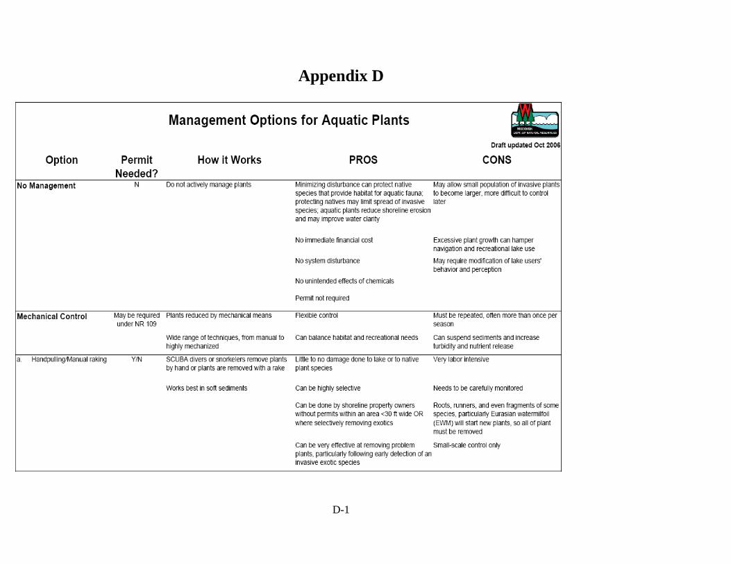
D-1
Appendix D

D-2
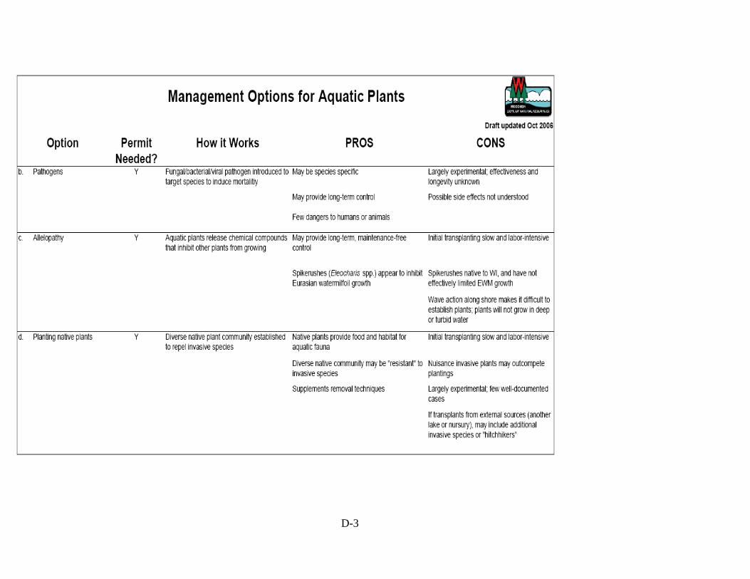
D-3

D-4
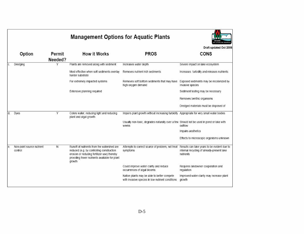
D-5

D-6

D-7

E-1
Appendix E
AQUATIC PLANT MANAGEMENT STRATEGY Northern Region WDNR Summer, 2007 AQUATIC PLANT MANAGEMENT STRATEGY Northern Region WDNR ISSUES • Protect desirable native aquatic plants. • Reduce the risk that invasive species replace desirable native aquatic plants. • Promote “whole lake” management plans • Limit the number of permits to control native aquatic plants. BACKGROUND As a general rule, the Northern Region has historically taken a protective approach to allow removal of native aquatic plants by harvesting or by chemical herbicide treatment. This approach has prevented lakes in the Northern Wisconsin from large-scale loss of native aquatic plants that represent naturally occurring high quality vegetation. Naturally occurring native plants provide a diversity of habitat that helps maintain water quality, helps sustain the fishing quality known for Northern Wisconsin, supports common lakeshore wildlife from loons to frogs, and helps to provide the aesthetics that collectively create the “up-north” appeal of the northwoods lake resources. In Northern Wisconsin lakes, an inventory of aquatic plants may often find 30 different species or more, whereas a similar survey of a Southern Wisconsin lake may often discover less than half that many species. Historically, similar species diversity was present in Southern Wisconsin, but has been lost gradually over time from stresses brought on by cultural land use changes (such as increased development, and intensive agriculture). Another point to note is that while there may be a greater variety of aquatic vegetation in Northern Wisconsin lakes, the vegetation itself is often less dense. This is because northern lakes have not suffered as greatly from nutrients and runoff as have many waters in Southern Wisconsin. The newest threat to native plants in Northern Wisconsin is from invasive species of aquatic plants. The most common include Eurasian Water Milfoil (EWM) and CurlyLeaf Pondweed (CLP). These species are described as opportunistic invaders. This means that these “invaders” benefit where an opening occurs from removal of plants, and without competition from other plants may successfully become established in a lake. Removal of native vegetation not only diminishes the natural qualities of a lake, it may increase the risk that an invasive species can

E-2
successfully invade onto the site where native plants have been removed. There it may more easily establish itself without the native plants to compete against. This concept is easily observed on land where bared soil is quickly taken over by replacement species (often weeds) that crowd in and establish themselves as new occupants of the site. While not providing a certain guarantee against invasive plants, protecting and allowing the native plants to remain may reduce the success of an invasive species becoming established on a lake. Once established, the invasive species cause far more inconvenience for all lake users, riparian and others included; can change many of the natural features of a lake; and often lead to expensive annual control plans. Native vegetation may cause localized concerns to some users, but as a natural feature of lakes, they generally do not cause harm. To the extent we can maintain the normal growth of native vegetation, Northern Wisconsin lakes can continue to offer the water resource appeal and benefits they’ve historically provided. A regional position on removal of aquatic plants that carefully recognizes how native aquatic plants benefit lakes in Northern Region can help prevent a gradual decline in the overall quality and recreational benefits that make these lakes attractive to people and still provide abundant fish, wildlife, and northwoods appeal. GOALS OF STRATEGY: 1. Preserve native species diversity which, in turn, fosters natural habitat for fish and other
aquatic species, from frogs to birds. 2. Prevent openings for invasive species to become established in the absence of the native
species. 3. Concentrate on a” whole-lake approach” for control of aquatic plants, thereby fostering
systematic documentation of conditions and specific targeting of invasive species as they exist.
4. Prohibit removal of wild rice. WDNR – Northern Region will not issue permits to remove wild rice unless a request is subjected to the full consultation process via the Voigt Tribal Task Force. We intend to discourage applications for removal of this ecologically and culturally important native plant.
5. To be consistent with our WDNR Water Division Goals (work reduction/disinvestment), established in 2005, to “not issue permits for chemical or large scale mechanical control of native aquatic plants – develop general permits as appropriate or inform applicants of exempted activities.” This process is similar to work done in other WDNR Regions, although not formalized as such.
BASIS OF STRATEGY IN STATE STATUTE AND ADMINISTRATIVE CODE State Statute 23.24 (2)(c) states: “The requirements promulgated under par. (a) 4. may specify any of the following: 1. The quantity of aquatic plants that may be managed under an aquatic plant management
permit.

E-3
2. The species of aquatic plants that may be managed under an aquatic plant management permit.
3. The areas in which aquatic plants may be managed under an aquatic plant management permit.
4. The methods that may be used to manage aquatic plants under an aquatic plant management permit.
5. The times during which aquatic plants may be managed under an aquatic plant management permit.
6. The allowable methods for disposing or using aquatic plants that are removed or controlled under an aquatic plant management permit.
7. The requirements for plans that the department may require under sub. (3) (b). “
State Statute 23.24(3)(b) states: “The department may require that an application for an aquatic plant management permit contain a plan for the department’s approval as to how the aquatic plants will be introduced, removed, or controlled.“ Wisconsin Administrative Code NR 109.04(3)(a) states: “The department may require that an application for an aquatic plant management permit contain an aquatic plant management plan that describes how the aquatic plants will be introduced, controlled, removed or disposed. Requirements for an aquatic plant management plan shall be made in writing stating the reason for the plan requirement. In deciding whether to require a plan, the department shall consider the potential for effects on protection and development of diverse and stable communities of native aquatic plants, for conflict with goals of other written ecological or lake management plans, for cumulative impacts and effect on the ecological values in the body of water, and the long-term sustainability of beneficial water use activities.” AQUATIC PLANT MANAGEMENT STRATEGY Northern Region WDNR APPROACH 1. After January 1, 2009* no individual permits for control of native aquatic plants will be
issued. Treatment of native species may be allowed under the auspices of an approved lake management plan, and only if the plan clearly documents “impairment of navigation” and/or “nuisance conditions”. Until January 1, 2009, individual permits will be issued to previous permit holders, only with adequate documentation of “impairment of navigation” and/or “nuisance conditions”. No new individual permits will be issued during the interim.
2. Control of aquatic plants (if allowed) in documented sensitive areas will follow the
conditions specified in the report.

E-4
3. Invasive species must be controlled under an approved lake management plan, with two exceptions (these exceptions are designed to allow sufficient time for lake associations to form and subsequently submit an approved lake management plan):
a. Newly-discovered infestations. If found on a lake with an approved lake management plan, the invasive species can be controlled via an amendment to the approved plan. If found on a lake without an approved management plan, the invasive species can be controlled under the WDNR’s Rapid Response protocol (see definition), and the lake owners will be encouraged to form a lake association and subsequently submit a lake management plan for WNDR review and approval.
b. Individuals holding past permits for control of invasive aquatic plants and/or “mixed stands” of native and invasive species will be allowed to treat via individual permit until January 1, 2009 if “impairment of navigation” and/or “nuisance conditions” is adequately documented, unless there is an approved lake management plan for the lake in question.
4. Control of invasive species or “mixed stands” of invasive and native plants will follow
current best management practices approved by the Department and contain an explanation of the strategy to be used. Established stands of invasive plants will generally use a control strategy based on Spring treatment. (typically, a water temperature of less than 60 degrees Fahrenheit, or approximately May 31st, annually).
5. Manual removal (see attached definition) is allowed (Admin. Code NR 109.06). --------------------------------------------------------------------------------------------------------------------- * Exceptions to the Jan. 1, 2009 deadline will be considered only on a very limited basis and will be intended to address unique situations that do not fall within the intent of this approach.

E-5
AQUATIC PLANT MANAGEMENT STRATEGY Northern Region WDNR DOCUMENTATION OF IMPAIRED NAVIGATION AND/OR NUISANCE CONDITIONS Navigation channels can be of two types: - Common use navigation channel. This is a common navigation route for the general lake user. It often is off shore and connects areas that boaters commonly would navigate to or across, and should be of public benefit. - Individual riparian access lane. This is an access lane to shore that normally is used by an individual riparian shore owner. Severe impairment or nuisance will generally mean vegetation grows thickly and forms mats on the water surface. Before issuance of a permit to use a regulated control method, a riparian will be asked to document the problem and show what efforts or adaptations have been made to use the site. (This is currently required in NR 107 and on the application form, but the following helps provide a specific description of what impairments exist from native plants). Documentation of impairment of navigation by native plants must include: a. Specific locations of navigation routes (preferably with GPS coordinates) b. Specific dimensions in length, width, and depth c. Specific times when plants cause the problem and how long the problem persists d. Adaptations or alternatives that have been considered by the lake shore user to avoid or
lessen the problem e. The species of plant or plants creating the nuisance (documented with samples or from a
Site inspection) Documentation of the nuisance must include: a. Specific periods of time when plants cause the problem, e.g. when does the problem start
and when does it go away. b. Photos of the nuisance are encouraged to help show what uses are limited and to show the
severity of the problem. c. Examples of specific activities that would normally be done where native plants occur
naturally on a site but cannot occur because native plants have become a nuisance.

E-6
AQUATIC PLANT MANAGEMENT STRATEGY Northern Region WDNR DEFINITIONS Manual removal: Removal by hand or hand-held devices without the use or aid of external or auxiliary power. Manual removal cannot exceed 30 ft. in width and can only be done where the shore is being used for a dock or swim raft. The 30 ft. wide removal zone cannot be moved, relocated, or expanded with the intent to gradually increase the area of plants removed. Wild rice may not be removed under this waiver. Native aquatic plants: Aquatic plants that are indigenous to the waters of this state. Invasive aquatic plants: Non-indigenous species whose introduction causes or is likely to cause economic or environmental harm or harm to human health. Sensitive area: Defined under s. NR 107.05(3)(i) (sensitive areas are areas of aquatic vegetation identified by the department as offering critical or unique fish and wildlife habitat, including seasonal or lifestage requirements, or offering water quality or erosion control benefits to the body of water). Rapid Response protocol: This is an internal WDNR document designed to provide guidance for grants awarded under NR 198.30 (Early Detection and Rapid Response Projects). These projects are intended to control pioneer infestations of aquatic invasive species before they become established.

F-1
Appendix F
RESULTS OF SEDIMENT CORE TAKEN FROM BIG DOCTOR LAKE, BURNETT COUNTY, WISCONSIN
Paul Garrison , Wisconsin Department of Natural Resources
April 2013 Aquatic organisms are good indicators of a lake’s water quality because they are in direct contact with the water and are strongly affected by the chemical composition of their surroundings. Most indicator groups grow rapidly and are short lived so the community composition responds rapidly to changing environmental conditions. One of the most useful organisms for paleolimnological analysis are diatoms. These are a type of algae which possess siliceous cell walls, which enables them to be highly resistant to degradation and are usually abundant, diverse, and well-preserved in sediments. They are especially useful, as they are ecologically diverse. Diatom species have unique features as shown in Figure 1, which enable them to be readily identified. Certain taxa are usually found under nutrient poor conditions while others are more common under elevated nutrient levels. Some species float in the open water areas while others grow attached to objects such as aquatic plants or the lake bottom.
Figure 1. Photomicrographs of the diatoms commonly found in the Big Doctor Lake sediment core. The top diatom, Aulacoseira ambigua (A), is found in the open water environments, the bottom left diatoms are part of the benthic Fragilaria (B), while the bottom left diatom (Eunotia incisa) is found in lower pH environments. Benthic Fragilaria are commonly found at- tached to substrates such as aquatic plants.
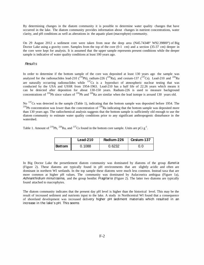
F-2
By determining changes in the diatom community it is possible to determine water quality changes that have occurred in the lake. The diatom community provides information about changes in nutrient concentrations, water clarity, and pH conditions as well as alterations in the aquatic plant (macrophyte) community. On 29 August 2012 a sediment core were taken from near the deep area (N45.74348° W92.39800°) of Big Doctor Lake using a gravity corer. Samples from the top of the core (0-1 cm) and a section (35-37 cm) deeper in the core were kept for analysis. It is assumed that the upper sample represents present conditions while the deeper sample is indicative of water quality conditions at least 100 years ago. Results
In order to determine if the bottom sample of the core was deposited at least 130 years ago the sample was analyzed for the radionuclides lead-210 (210Pb), radium-226 (226Ra), and cesium-137 (137Cs). Lead-210 and 226Ra are naturally occurring radionuclides while 137Cs is a byproduct of atmospheric nuclear testing that was conducted by the USA and USSR from 1954-1963. Lead-210 has a half life of 22.26 years which means it can be detected after deposition for about 130-150 years. Radium-226 is used to measure background concentrations of 210Pb since values of 210Pb and 226Ra are similar when the lead isotope is around 130 years old.
No 137Cs was detected in the sample (Table 1), indicating that the bottom sample was deposited before 1954. The 210Pb concentration was lower than the concentration of 226Ra indicating that the bottom sample was deposited more than 130 years ago. The radiochemical analysis suggests that the bottom sample is sufficiently old enough to use the diatom community to estimate water quality conditions prior to any significant anthropogenic disturbance in the watershed.
Table 1. Amount of 210Pb, 226Ra, and 137Cs found in the bottom core sample. Units are pCi g-1.
Lead-210 Radium-226 Cesium-137
Bottom 0.1088 0.6232 0.0
In Big Doctor Lake the presettlement diatom community was dominated by diatoms of the group Eunotia (Figure 2). These diatoms are typically found in pH environments that are slightly acidic and often are dominant in northern WI wetlands. In the top sample these diatoms were much less common. Instead taxa that are more common at higher pH values. The community was dominated by Aulacoseira ambigua (Figure 1a), Achnanthidium minutissima, and the group benthic Fragilaria (Figure 2). The latter two diatoms are typically found attached to macrophytes. The diatom community indicates that the present day pH level is higher than the historical level. This may be the result of increased sediment and nutrients input to the lake. A study in Northcentral WI found that a consequence of shoreland development was increased delivery higher pH sediment materials which resulted in an increase in the lake’s pH. This seems
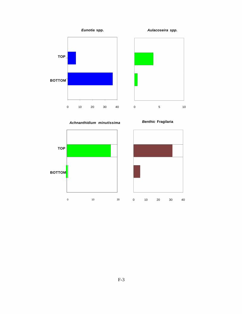
F-3
Eunotia spp. Aulacoseira spp.
TOP
BOTTOM
0 10 20 30 40 0 5 10
Achnanthidium minutissima
Benthic Fragilaria
TOP
BOTTOM
0 10 20 0 10 20 30 40

F-4
to have occurred in Big Doctor Lake. The increase in benthic Fragilaria and A. minutissima indicate there are more submerged aquatic plants (SAV) at the present time.
In northern WI, many lakes with shoreline development have experienced an increase in SAV. Dr. Susan Borman recently conducted a study in lakes in the northwestern part of WI where she compared the SAV community in the 1930s with the present day community. She found that lakes with cottages have more plants and the species have shifted to those that are larger and grow closer to the lake’s surface. This same thing has occurred in southern and central WI but often these lakes have higher phosphorus loading rates and planktonic diatoms become more important. The change in the plant community appears to have happened in Big Doctor Lake as the top sample has more diatoms that typically are associated with aquatic plants.
Diatom assemblages historically have been used as indicators of nutrient changes in a qualitative way. In recent years, ecologically relevant statistical methods have been developed to infer environmental conditions from diatom assemblages. These methods are based on multivariate ordination and weighted averaging regression and calibration. Ecological preferences of diatom species are determined by relating modern limnological variables to surface sediment diatom assemblages. The species-environment relationships are then used to infer en- vironmental conditions from fossil diatom assemblages found in the sediment core.
Such a model was applied to the diatom community in the core from Big Doctor Lake. The model estimates a summer phosphorus concentration of about 25 µg L-1 which is much lower than has been measured in the last few years. The concentration measured in 2012 was generally between 80-90 µg L-1. The model significantly under estimates the present day phosphorus levels so the model estimates of historical phosphorus concentrations of 13-15 µ g L-1 are suspect. Judging from the change in the diatom community I would speculate that present day phosphorus levels are higher than historical ones but I do not know how much higher they are.
In the bottom sample there were a large number of sponge spicules and phytoliths but not many in the top sample. This is further indication that the lake has higher phosphorus levels at the present time compared with pre-settlement conditions. Sponges are usually found in relatively good water clarity conditions and phytoliths are an indication of abundant emergent aquatic plants.
In summary, the bottom sample of the sediment core was deposited at least 130 years ago which means that it can be used to estimate background conditions. The core indicates that there has been an increase in the pH level in the lake and at the present time the aquatic plant community is greater than it was historically. Although the modeling indicates summer phosphorus levels have increased from 13 to 25 µg L-1 this is suspect since the present day concentration is underestimated. It is likely that phosphorus levels have increased but it is difficult to know what the historical levels were.
Figure 2. Changes in the abundance of important diatoms found at the top and bottom of the Big Doc- tor Lake sediment core. The dominant diatoms at the bottom of the core were Eunotica which are typically found in lower pH environments. At the top of the core the diatoms that grow attached to aquatic plants are more common. This indicates an increase in growth of submerged aquatic vegeta- tion. Aulacoseira are found floating the open water and probably indicate higher nutrient levels.

F-5
BIG DOCTOR LAKE Burnett County Top (0-2 cm)
COUNT TOTAL Number Prop.
TAXA Achnanthidium altergracillima (Lange-Bertalot) Round et Bukhtiyarova 2 0.004 Achnanthidium minutissimum (Kützing) Czarnecki 87 0.174 Achnanthidium rivulare Potapova et Ponader 2 0.004 Aulacoseira ambigua (Grunow in Van Heurck) Simonsen 13 0.026 Aulacoseira distans (Ehrenberg) Simonsen 1 0.002 Aulacoseira italica (Ehrenberg) Simonsen 5 0.010 Aulacoseira spp. 2 0.004 Brachysira microcephala (Kützing) Compère 5 0.010 Brachysira serians (Brébisson) Round et Mann 1 0.002 Brachysira spp. 1 0.002 Cavinula pseudoscutiformis (Hustedt in Schmidt et al.) Mann et Stickle in Round, Crawford and Mann
1
0.002
Cocconeis placentula Ehrenberg 9 0.018 Cocconeis spp. 6 0.012 Cymbella mesiana Cholnoky 2 0.004 Cymbella naviculiformis Auerswald ex Heiberg 1 0.002 Cymbella spp. 2 0.004 Discostella stelligera (Cleve et Grunow in Cleve) Houk et Klee 1 0.002 Encyonema minutum (Hilse in Rabenhorst) Mann in Round, Crawford and Mann
5
0.010
Eunotia bilunaris (Ehrenberg) Souza in Souza and Moreira-Filho 1 0.002 Eunotia circumborealis Lange-Bertalot et Nörpel in Lange-Bertalot 6 0.012 Eunotia incisa Smith ex Gregory 13 0.026 Eunotia minor (Kützing) Grunow in Van Heurck 4 0.008 Eunotia parallela Ehrenberg 2 0.004 Eunotia serra Ehrenberg 1 0.002 Eunotia spp. 6 0.012 Fragilaria radians (Kützing) Williams et Round 9 0.018 Fragilaria sepes Ehrenberg 1 0.002 Fragilaria tenera (Smith) Lange-Bertalot 4 0.008 Gomphonema anjae Lange-Bertalot & Reidhardt 1 0.002 Gomphonema exilissimum (Grunow in Van Heurck) Lange-Bertalot et Reichardt in Lange-Bertalot and Metzeltin
3
0.006
Gomphonema parvulum (Kützing) Kützing 2 0.004 Gomphonema parvulum fo. saprophilum Lange-Bertalot et Reichardt in Lange-Bertalot
1
0.002
Gomphonema spp. 3 0.006 Hantzschia amphioxys (Ehrenberg) Grunow in Cleve and Grunow 1 0.002

BIG DOCTOR LAKE Burnett County Top (0-2 cm)
COUNT TOTAL Number Prop.
TAXA Navicula joubaudii Germain 4 0.008 Navicula leptostriata Jørgensen 4 0.008 Navicula minima Grunow in Van Heurck 2 0.004 Navicula spp. 7 0.014 Navicula subminuscula Manguin 7 0.014 Navicula utermoehlii Hustedt in A. Schmidt 4 0.008 Neidium bisulcatum (Lagerstedt) Cleve 2 0.004 Neidium spp. 2 0.004 Nitzschia dissipata var. media (Hantzsch) Grunow in Van Heurck 2 0.004 Nitzschia palea var. debilis (Kützing) Grunow in Cleve and Grunow 1 0.002 Nitzschia spp. 7 0.014 Nupela fennica (Hustedt) Lange-Bertalot in Krammer and Lange-Bertalot 2 0.004 Nupela impexiformis (Lange-Bertalot in Lange-Bertalot and Krammer) Lange -Bertalot
5
0.010
Nupela sp. 1 ? 6 0.012 Nupela vitiosa (Schimanski) Siver et Hamilton 10 0.020 Nupela wellneri (Lange-Bertalot in Lange-Bertalot and Krammer) Lange- Bertalot in U. Rumrich, Lange-Bertalot and M. Rumrich
2
0.004
Pinnularia rupestris Hantzsch in Rabenhorst 1 0.002 Pinnularia spp. 7 0.014 Psammothidium subatomoides (Hustedt in Schmidt) Bukhtiyarova et Round 2 0.004 Pseudostaurosira brevistriata (Grunow in Van Heurck) Williams et Round 63 0.126 Punctastriata mimetica Morales 2 0.004 Sellaphora disjuncta (Hustedt) Mann 2 0.004 Sellaphora laevissima (Kützing) Mann 2 0.004 Sellaphora pupula (Kützing) Meresckowsky 2 0.004 Sellaphora rectangularis (Gregory) Lange-Bertalot et Metzeltin 1 0.002 Sellaphora seminulum (Grunow) Mann 9 0.018 Sellaphora sp. 1 ? 1 0.002 Stauroforma exiguiformis (Lange-Bertalot) Flower, Jones et Round 2 0.004 Stauroneis anceps fo. gracilis Rabenhorst 1 0.002 Stauroneis spp. 2 0.004 Staurosira construens var. venter (Ehrenberg) Hamilton in Hamilton, Poulin, Charles and Angell
38
0.076
Staurosirella pinnata (Ehrenberg) Williams et Round 52 0.104 Synedra delicatissima var. angustissima Grunow in Van Heurck 5 0.010 Synedra minuscula Grunow in Van Heurck 4 0.008 Synedra rumpens Kützing 4 0.008 Synedra spp. 2 0.004

Tabellaria flocculosa (strain III) sensu Koppen (Roth) Kützing 7 0.014 Tabellaria flocculosa var. linearis Koppen 1 0.002 Tabellaria spp. 2 0.004 Tabellaria ventricosa Kützing 1 0.002 Tryblionella scalaris (Ehrenberg) Siver et Hamilton 1 0.002 unknown pennate 15 0.030 TOTAL 500 1.000

7
BIG DOCTOR LAKE Burnett County Bottom (35-37 cm) lots of diatoms fragments; sponge spicules and phytoliths
COUNT TOTAL Number Prop.
TAXA Achnanthidium altergracillima (Lange-Bertalot) Round et Bukhtiyarova 1 0.002 Achnanthidium minutissimum (Kützing) Czarnecki 3 0.006 Aulacoseira italica (Ehrenberg) Simonsen 2 0.004 Aulacoseira nygaardii (Camburn in Camburn and Kingston) Camburn et Charles 1 0.002 Cymbella mesiana Cholnoky 2 0.004 Cymbella spp. 3 0.006 Encyonema minutum (Hilse in Rabenhorst) Mann in Round, Crawford and Mann 7 0.014 Encyonema silesiacum (Bleisch in Rabenhorst) Mann in Round, Crawford and Mann
4
0.008 Encyonopsis sp. 1 ? 11 0.021 Eunotia bilunaris (Ehrenberg) Souza in Souza and Moreira-Filho 1 0.002 Eunotia carolina Patrick 38 0.074 Eunotia circumborealis Lange-Bertalot et Nörpel in Lange-Bertalot 1 0.002 Eunotia faba (Ehrenberg) Grunow in Van Heurck 3 0.006 Eunotia flexuosa (Brébisson ex Kutzing) Kützing 24 0.047 Eunotia formica Ehrenberg 7 0.014 Eunotia hexaglyphis Ehrenberg 4 0.008 Eunotia implicata Nörpel, Alles et Lange-Bertalot in Alles, Nörpel and Lange- Bertalot
2
0.004 Eunotia incisa Smith ex Gregory 79 0.154 Eunotia intermedia (Krasske ex Hustedt) Nörpel et Lange-Bertalot in Lange- Bertalot
6
0.012 Eunotia parallela Ehrenberg 1 0.002 Eunotia praerupta Ehrenberg 6 0.012 Eunotia rhomboidea Hustedt 3 0.006 Eunotia spp. 11 0.021 Fragilaria famelica (Kützing) Lange-Bertalot 1 0.002 Fragilaria vaucheriae (Kützing) Petersen 2 0.004 Gomphonema acuminatum Ehrenberg 7 0.014 Gomphonema auritum Braun & Kutzing 1 0.002 Gomphonema exilissimum (Grunow in Van Heurck) Lange-Bertalot et Reichardt in Lange-Bertalot and Metzeltin
3
0.006 Gomphonema gracile Ehrenberg 11 0.021 Gomphonema hebridense Gregory 1 0.002 Gomphonema maclaughlinii Reichardt 4 0.008 Gomphonema minutum (Agardh) Agardh 16 0.031 Gomphonema minutum fo. curtum (Hustedt) Lange-Bertalot et Reichardt in Krammer and Lange-Bertalot
7
0.014

G-1
BIG DOCTOR LAKE Burnett County Bottom (35-37 cm) lots of diatoms fragments; sponge spicules and phytoliths
COUNT TOTAL Numbe r Prop.
TAXA Gomphonema parvulius (Lange-Bertalot et Reichardt) Lange-Bertalot et Reich- ardt in Lange-Bertalot and Metzeltin
9
0.038 Gomphonema parvulum (Kützing) Kützing 2 0.008 Gomphonema sp. 1 Big Doctor 3 0.013 Gomphonema sp. 26 NAWQA EAM 1 0.004 Gomphonema spp. 10 0.042 Gomphonema truncatum Ehrenberg 3 0.013 Hantzschia amphioxys (Ehrenberg) Grunow in Cleve and Grunow 1 0.004 Navicula spp. 4 0.017 Navicula vulpina Kützing 21 0.088 Neidium ampliatum (Ehrenberg) Krammer in Krammer and Lange-Bertalot 1 0.004 Neidium spp. 13 0.054 Neidium temperei Reimer 3 0.013 Pinnularia maior (Kützing) Rabenhorst 2 0.008 Pinnularia microstauron (Ehrenberg) Cleve 2 0.008 Pinnularia pseudogibba Krammer 4 0.017 Pinnularia spp. 7 0.029 Pinnularia subgibba Krammer 3 0.013 Pinnularia viridiformis Krammer 6 0.025 Pinnularia viridis (Nitzsch) Ehrenberg 1 0.004 Sellaphora americana (Ehrenberg) Mann 2 0.008 Sellaphora laevissima (Kützing) Mann 5 0.021 Sellaphora pupula (Kützing) Meresckowsky 3 0.013 Sellaphora rectangularis (Gregory) Lange-Bertalot et Metzeltin 9 0.038 Sellaphora rugula (Hohn & Hellerman) Potapova & Ponader 1 0.004 Sellaphora spp. 3 0.013 Stauroneis anceps Ehrenberg 3 0.013 Stauroneis gracilior (rabenhorst) Reichardt 1 0.004 Stauroneis phoenicenteron (Nitzsch) Ehrenberg 5 0.021 Stauroneis spp. 10 0.042 Staurosira construens var. venter (Ehrenberg) Hamilton in Hamilton, Poulin, Charles and Angell
27
0.113
Synedra delicatissima Smith 2 0.008 Synedra rumpens Kützing 2 0.008 Synedra spp. 1 0.004 Synedra ulna var. danica (Kützing) Grunow in Van Heurck 1 0.004 Tabellaria flocculosa (strain III) sensu Koppen (Roth) Kützing 12 0.050

G-1
Tabellaria flocculosa var. linearis Koppen 9 0.038 Tabellaria spp. 6 0.025 Undetermined Pennate 41 0.172 TOTAL 2 39 1.000

G-1
Appendix G References
Aquatic Ecosystem Restoration Foundation. Aquatic Plant Management: Best Management Practices in Support of Fish and Wildlife Habitat. 2005. http://www.aquatics.org/aquatic_bmp.pdf Beckmann, Todd. Aquatic invasives still a concern in Burnett County. Burnett County Sentinel. May 28, 2008. Berg, Matthew S., Endangered Resources Services, LLC. Aquatic Macrophyte Surveys for Lipsett Lake, Burnett County, Wisconsin. July 2007. Borman, Susan, Robert Korth and Jo Tempte. Through the Looking Glass. University of Wisconsin-Extension. Stevens Point, Wisconsin. 1997. Crow, Garrett E. and C. Barre Hellquist. Aquatic and Wetland Plants of Northeastern North America. The University of Wisconsin Press. Madison, Wisconsin. Volumes 1 and 2. 2000. Garrison, Paul. Wisconsin Department of Natural Resources Lakes Biologist. Results of Sediment Core Taken From Big Doctor Lake – August 29, 2012, Burnett County, Wisconsin. August, 2012. Harmony Environmental. Aquatic Plant Management Plan. Big and Little Dummy Lakes, Burnett County, Wisconsin. January 2009. Harmony Environmental. Aquatic Plant Management Plan. Burnett County, Wisconsin. 2009. Hraychuck, Ann. Invasive Species Month. Inter-County Leader. June 13, 2007. Nichols, Stanley A. Distribution and Habitat Descriptions of Wisconsin Lake Plants. Wisconsin Geological and Natural History Survey. Bulletin 96. Madison Wisconsin.1999. Nichols, Stanley A. Floristic Quality Assessment of Wisconsin Lake Plant Communities with Example Applications. Journal of Lake and Reservoir Management 15 (2): 133-141. 1999. North American Lake Management Society. Managing Lakes and Reservoirs. 2001. Roesler, Craig. Wisconsin Department of Natural Resources Lakes Biologist. Siren WWTP Effluent Flow Path Evaluation. May 8, 2012. University of Wisconsin-Extension. Phosphorus Levels in the Red Cedar River Basin: A Source of Concern.

G-1
University of Wisconsin-Extension. Citizen Lake Monitoring Manual. Revised 2006. University of Wisconsin-Extension. Aquatic Plant Management in Wisconsin. April 2006 Draft. University of Wisconsin – Madison. Wisconsin State Herbarium. WISFLORA: Wisconsin Vascular Plant Species. www.botany.wisc.edu/wisflora/ U.S. Army Corps of Engineers. Aquatic Plant Information System (APIS). 2005. Vilas County Land and Water Conservation Department. Aquatic Invasive Species: A Guide for Proactive & Reactive Management. 2006. http://wisconsinlakes.org/AboutLakes/PDFs/aisguidevc06.pdf Wendell, Jameson. Wisconsin Department of Natural Resources, Fisheries Biologist. Fish Species List for Big Doctor Lake. August, 2012. Wisconsin Department of Natural Resources. Control of Eurasian Water Milfoil & Large-scale Aquatic Herbicide Use. July 2006. Wisconsin Department of Natural Resources. Eau Claire, WI. Designation of Critical Habitat Areas. Bear Lake, Portage County. March 2007. Wisconsin Department of Natural Resources. Fisheries Information Sheet Big Doctor Lake, Burnett County, 2008. Wisconsin Department of Natural Resources. Fisheries in the Wisconsin Ceded Territory. Last revised March 27, 2009. Wisconsin Department of Natural Resources. Natural Heritage Inventory County Data by Township: Burnett County. Last revised December 2008. Wisconsin Department of Natural Resources. Northern Region. Aquatic Plant Management Strategy. Summer 2007. Wisconsin Department of Natural Resources. Reports and Data: Burnett County. June 2009. <http://www.dnr.state.wi.us/lakes/CLMN/reportsanddata/> Wisconsin Department of Natural Resources. The State of the St. Croix River Basin. 2002. Wisconsin Department of Natural Resources. Walleye Bag Limits Revised on 255 Northern Lakes. May 19, 2009. Wisconsin Department of Natural Resources. WISCLAND Digital Land Cover. 1998.


![3.3 Aquatic Resources - California State Water Resources ... · Section 3.3.5 [Aquatic Resources] Potential Impacts and Mitigation. 3.3.2.1 Aquatic Species Numerous aquatic species](https://img.pdfslide.net/doc/110x75/5fdf05efaeffa42ca171b579/33-aquatic-resources-california-state-water-resources-section-335-aquatic.jpg)