Embed Size (px)
Citation preview
8/8/2019 Bigley Farm - Alvediston
http://slidepdf.com/reader/full/bigley-farm-alvediston 1/19
Wessex Archaeology
July 2006Ref: 62460.02
SHEEP SHELTERS, BIGLEY FARM,ALVEDISTON, WILTSHIRE
Watching Brief Report
8/8/2019 Bigley Farm - Alvediston
http://slidepdf.com/reader/full/bigley-farm-alvediston 2/19
Sheep Shelters, Bigley Farm,Alvediston, Wiltshire
Watching Brief Report
Prepared on behalf of:
Mr. DinelyBigley Buildings
AlvedistonWiltshire
By:
Wessex ArchaeologyPortway House
Old Sarum Park SALISBURY
WiltshireSP4 6EB
Report reference: 62460.02
June 2006
© Wessex Archaeology Limited 2006 all rights reserved Wessex Archaeology Limited is a Registered Charity No. 287786
8/8/2019 Bigley Farm - Alvediston
http://slidepdf.com/reader/full/bigley-farm-alvediston 3/19
8/8/2019 Bigley Farm - Alvediston
http://slidepdf.com/reader/full/bigley-farm-alvediston 4/19
Sheep Shelters, Bigley Farm,Alvediston, Wiltshire
Watching Brief Report
SUMMARY
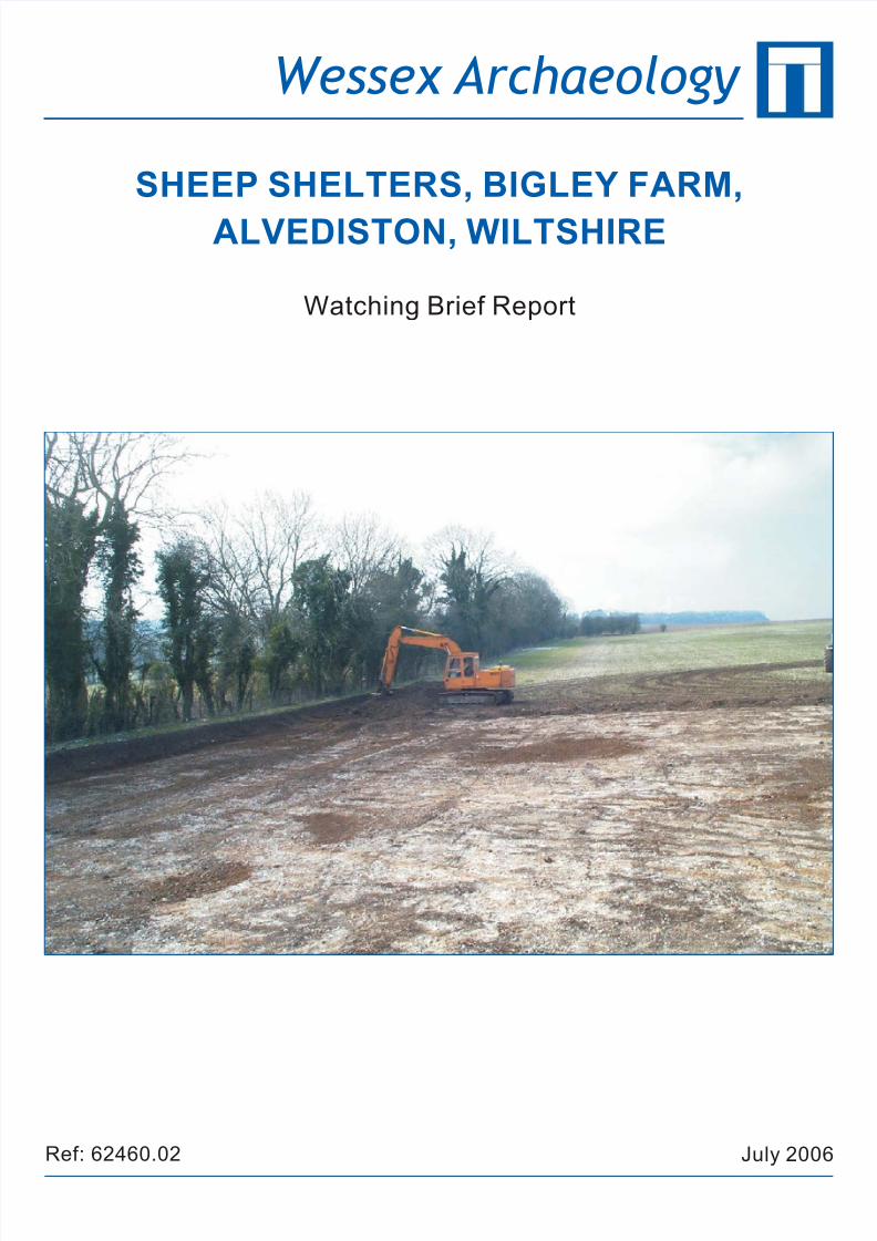
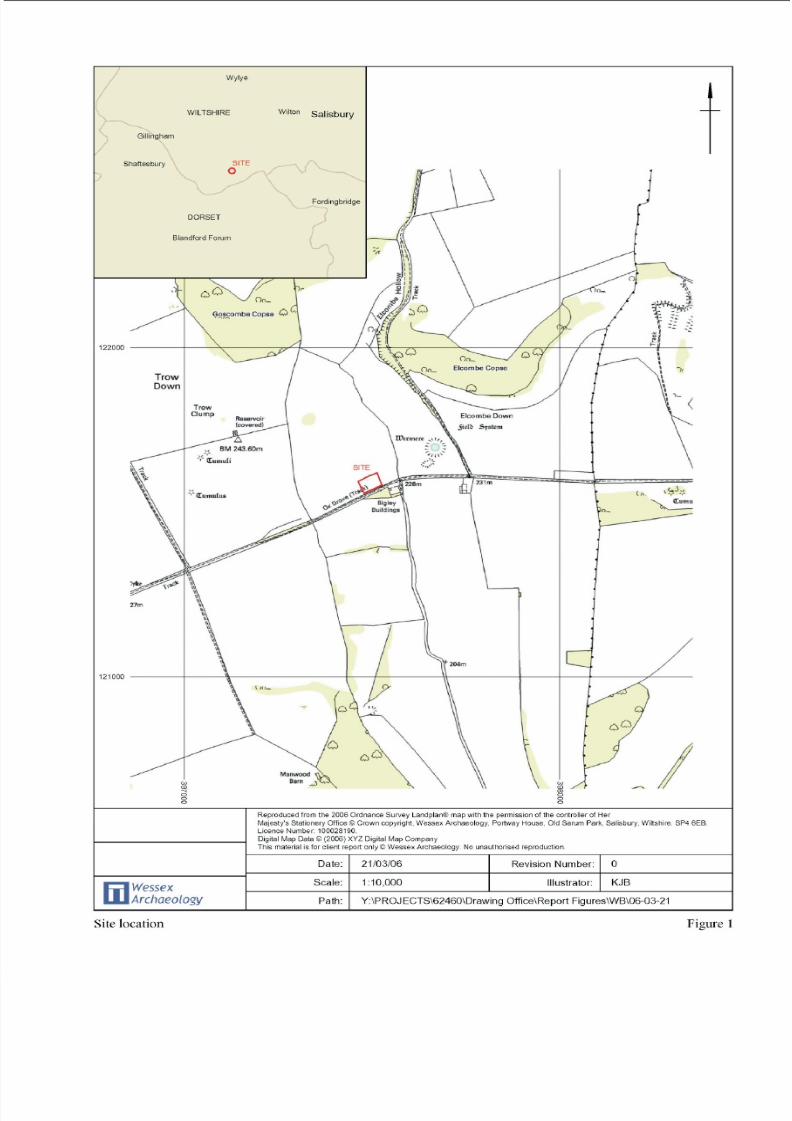
In March 2006 Wessex Archaeology was commissioned by Mr. Dinely of BigleyFarm (also known as Bigley Buildings) to carry out an archaeological watching brief at Alvediston, Wiltshire, centred on National Grid Reference 397497 121580 ( Figure1).
A total of eight archaeological features were recorded. Two features were similar pitsof Romano-British date containing quantities of unworked burnt flint. The remainingsix features were a sequence of undated parallel linear features located in the south of the Site. These were considered to be Drovers’ paths associated with the ‘Ox Drove,’a trackway forming the southern boundary to the Site.
ii
8/8/2019 Bigley Farm - Alvediston
http://slidepdf.com/reader/full/bigley-farm-alvediston 5/19
Sheep Shelters, Bigley Farm,Alvediston, Wiltshire
Watching Brief Report
Acknowledgements
The project was commissioned by Mr. Dinely of Bigley Farm, Alvediston. WessexArchaeology would also like to thank associated groundworks staff for their co-operation during the course of the Site strip. Ms H Cave-Penny, County
Archaeological Officer for Wiltshire County Council, approved the Written Schemeof Investigation for the works.
The fieldwork was undertaken by Stephen Legg, who also compiled this report,assisted by Dave Murdie. The analysis and reporting of the finds was provided byLorraine Mepham. Environmental analysis was undertaken by Chris Stevens, thesamples were processed by Lee Newton. The illustrations were prepared by KittyBrandon and Mark Roughley. The project was managed by Peter Reeves on behalf of Wessex Archaeology.
iii
8/8/2019 Bigley Farm - Alvediston
http://slidepdf.com/reader/full/bigley-farm-alvediston 6/19
Sheep Shelters, Bigley Farm,Alvediston, Wiltshire
Watching Brief Report
1 INTRODUCTION
1.1 Project background
1.1.1 Wessex Archaeology was commissioned by Mr. Dinely to undertake anarchaeological watching brief during groundworks, associated with theconstruction of sheep shelters, on a plot of land to the north west of BigleyBuildings, Alvediston, Wiltshire; hereafter referred to as ‘the Site’, centred
on National Grid Reference 397497 121580 ( Figure 1 ).
1.1.2 The requirement for an archaeological watching brief was attached as acondition to planning permission (S/2005/349) granted by Salisbury DistrictCouncil, and followed the advice of the Wiltshire County ArchaeologyService that the site may contain features of archaeological interest.
1.1.3 The watching brief was carried out between 02 February 2006 and 06February 2006. It involved the removal of soil horizons down to natural
geology over an area of 2145 square metres (0.2ha), prior to the levelling andlandscaping of the shelter area by cutting into the Upper Chalk.
1.2 Location, Topography and Geology
1.2.1 The Site occupies an area 55m by 39m (0.2ha) on a gentle to moderate southfacing slope towards the brow of a Chalk Downland ridge, to the immediatenorth of a trackway known as ‘Ox Drove,’ which forms the southern
boundary to the Site.
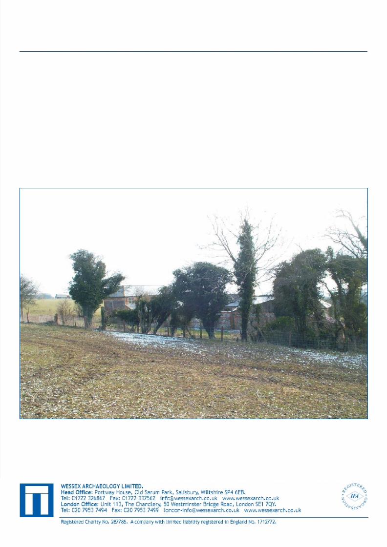
1.2.2 Bigley Buildings lie some 60m to the east on the south side of ‘Ox Drove’.The area around the Site is a mixture of pasture and arable land.
1.2.3 The underlying geology of the area is Upper Chalk, the surface of whichcontains much nodular flint.
1
8/8/2019 Bigley Farm - Alvediston
http://slidepdf.com/reader/full/bigley-farm-alvediston 7/19
1.3 Archaeological Background
1.3.1 Prehistoric activities in the area are highlighted by a number of field system
remnants, which include cross-ridge dykes to east and west. Tumuli, of likelyBronze Age date, are also visible along the ridge to both east (760m) andwest (460m), although none are evident within the immediate area of theSite.
1.3.2 Approximately 200m to the north-east lies a ‘dewpond’ called by the Saxonname ‘Wermere’ in 1618 (VCH 1987, 7). This feature is nearly 60m indiameter and, on inspection, is probably a large solution hollow, with thecentral portion retaining water content into ‘even the driest summer.’ It has
been tested for depth in recent times by driving drainpipe segments into the
soft silts at its base. These were driven in to a depth exceeding 6m, the softsilts were perceived to continue beyond this depth (Mr. Dinely, pers. comm. ).Aerial photographs have identified the remains of a field system that may or may not be associated with the pond.
1.3.3 The southern boundary to the Site is ‘Ox Drove,’ a drover’s track with acentral ‘hollow way’ along the south side of the ridge. This was certainly inuse in the 19 th Century (VCH 1987, 17). The ‘Ox Drove’ is an extensivetrackway crossing a number of parishes in southern Wiltshire, only parts of which were metalled. It is highly probable, though not proven through
archaeological research, that the trackway is significantly older forming anearly prehistoric route across the downs. Cartographic analysis indicatesolder prehistoric monuments, round barrows and dyke systems, respectingthe route of the trackway.
1.3.4 Bigley Buildings located to the south east of the Site formerly comprised aDrover’s Inn. Some of the original architectural features are retained and
preserved in the modern building.
1.3.5 To the immediate west of these buildings another dewpond is also reported tohave existed, although it was back-filled in the 1930s following the drowningof a young boy (Mrs. Dinely, pers. comm. ).
1.3.6 The northern portion of the ridge on which the Site is situated was formerlyoccupied by Goscombe Copse - recorded extent of 5 acres in 1664 (VCH1987, 7). Although still extant within the landscape the copse has shrunk.Goscombe Copse was probably part of a larger area of woodland linkingElcombe Copse to the east and Manwood Copse to the south.
1.3.7 Bigley Buildings, or rather, the Drovers Inn formerly at this location, isideally situated for a break in long distance movement of cattle and may have
2
8/8/2019 Bigley Farm - Alvediston
http://slidepdf.com/reader/full/bigley-farm-alvediston 8/19
8/8/2019 Bigley Farm - Alvediston
http://slidepdf.com/reader/full/bigley-farm-alvediston 9/19
containing very few pieces of struck or burnt flints. Despite the mixing of materials by ploughing this suggests a lack of prehistoric settlement activitieson the Site although there is evidence for prehistoric farming in adjacentareas.
3.1.3 Where the plough-soil is deeper in the south it overlies subsoil ( 102 ), whichhas also formed under successive ploughs and is better preserved. Noarchaeological features were observed within this horizon.
3.1.4 The increased depth of plough-soil and the presence of underlying subsoil, inthe southern area of the Site, has preserved the northern edge of the original‘Ox Drove’. Post-medieval farming practises have resulted in the former trackway being encroached upon by the current field system.Geomorphologically the chalk ridge becomes steeper towards the north,
although recent farming practise has caused the surface contours of the fieldhere to become degraded.
3.1.5 Plough scars evident upon the surface of the Upper Chalk show cross- ploughing activities. The natural geology also shows evidence of peri-glacialfeatures most notably ‘tiger stripes’. A number of pockets of ‘Clay-with-flints,’ were probably formed, as a direct result of tree root penetration intothe underlying Upper Chalk and are evidence of the former extent of woodland. The presence of copses on the ridge tops to the north and southsupport the suggestion that the former woodland extended across the area
bounded by the Site.
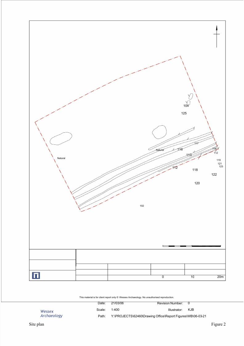
3.1.6 Two of the tree root hollows were present in the prehistoric period as twosub-rectangular ‘pits’ were cut into such hollows on the eastern side of theSite. These features ( 104 , 125 ) were filled with unworked burnt flint. Therewas no evidence of in situ burning so this material had either beendeliberately dumped into the hollows, or had entered the archaeologicalrecord through colluvial process.
3.1.7 Given the distinct paucity of struck and burnt flints within the plough-soilcolluvial build-up is unlikely, which suggests a more deliberate process of deposition. No other features of this date were observed within Site limits.
3.1.8 Pit 104 was dated to the Romano-British period on the basis of a curved bodysherd of grog-tempered pottery. The absence of struck flakes from the burntflint assemblage is also generally indicative of a Romano-British date for thiscontext. Pit 125 was allocated a contemporary date on the basis of contextsimilarity. Both pits were sampled for environmental and artefact collection.
3.1.9 Six linear features, all relatively shallow and truncated by ploughing, crossthe Site in the south. The features were aligned generally parallel to each
4
8/8/2019 Bigley Farm - Alvediston
http://slidepdf.com/reader/full/bigley-farm-alvediston 10/19
8/8/2019 Bigley Farm - Alvediston
http://slidepdf.com/reader/full/bigley-farm-alvediston 11/19
4 FINDS
4.1.1 The evaluation produced a very small quantity of finds, deriving from topsoiland from three discrete features. Table 1 (below) presents a quantification of all finds by context.
Table 1: Finds by context (number / weight in grammes)
CBM = ceramic building material
Context DescriptionBurntFlint CBM
FiredClay
WorkedFlint Iron Pottery
101 topsoil 1/9 3/51 4/28 1/69105 pit 104 31/1078106 pit 104 2/27 13/59 2/46112 linear 111 1/5119 linear 118 3/44 1/1
TOTALS 38/1163 3/51 13/59 5/29 1/69 2/46
4.1.2 Of this small assemblage, only the pottery is closely datable; the two sherdsrecovered (both from pit 104 ) are of Romano-British date, one in an oxidisedsandy fabric and the second grog-tempered. Fragments of ceramic buildingmaterial (from the topsoil) are undiagnostic but probably post-medieval, as isthe large iron bolt and attached washer from the same context. The fired clay(pit 104 ) comprises small, featureless and abraded fragments of uncertain date,
possibly of structural origin. Worked flint flakes (topsoil and linear 118 ) are patinated and edge damaged; they are prehistoric but not chronologicallydistinctive. Burnt, unworked flint constituted the most commonly occurringmaterial type (concentrated in pit 104 ); this material type is frequently (but notexclusively) associated with prehistoric activity.
4.1.3 This small assemblage of finds is not recommended for long term curation.
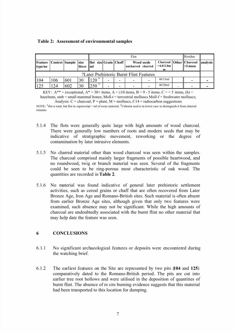
5 ENVIRONMENTAL
5.1.1 Two bulk samples were taken from burnt flint filled features of Romano-
British date and were processed for the recovery and assessment of charred plant remains and charcoal.
5.1.2 No charred material associated with settlement activities were recovered.
5.1.3 The bulk samples were processed by standard flotation methods and the resultsare presented in Table 2 (below). Preliminary identifications of dominant or important taxa are noted below, following the nomenclature of Stace (1997).
6
8/8/2019 Bigley Farm - Alvediston
http://slidepdf.com/reader/full/bigley-farm-alvediston 12/19
Table 2: Assessment of environmental samples
FlotResidue
Featuretype/no
Context Sample sizelitres
flot sizeml
Grain Chaff Weeduncharred
seedscharred
Charcoal>4.0/2.0m
m
Other Charcoal>5.6mm
analysis
?Later Prehistoric Burnt Flint Features104 106 601 30 120
30
- - - - 40/15ml _ - -125 124 602 30 250
30
- - - - 40/20ml _ - -KEY : A** = exceptional, A* = 30+ items, A = t 10 items, B = 9 - 5 items, C = < 5 items, (h) =
hazelnuts, smb = small mammal bones; Moll-t = terrestrial molluscs Moll-f = freshwater molluscs;Analysis: C = charcoal, P = plant, M = molluscs, C14 = radiocarbon suggestions
NOTE : 1flot is total, but flot in superscript = ml of rooty material. 2Unburnt seed is in lower case to distinguish it from charredremains
5.1.4 The flots were generally quite large with high amounts of wood charcoal.There were generally low numbers of roots and modern seeds that may beindicative of stratigraphic movement, reworking or the degree of contamination by later intrusive elements.
5.1.5 No charred material other than wood charcoal was seen within the samples.The charcoal comprised mainly larger fragments of possible heartwood, andno roundwood, twig or branch material was seen. Several of the fragmentscould be seen to be ring-porous most characteristic of oak wood. The
quantities are recorded in Table 2 .
5.1.6 No material was found indicative of general later prehistoric settlementactivities, such as cereal grains or chaff that are often recovered from Later Bronze Age, Iron Age and Romano-British sites. Such material is often absentfrom earlier Bronze Age sites, although given that only two features wereexamined, such absence may not be significant. While the high amounts of charcoal are undoubtedly associated with the burnt flint no other material thatmay help date the feature was seen.
6 CONCLUSIONS
6.1.1 No significant archaeological features or deposits were encountered duringthe watching brief.
6.1.2 The earliest features on the Site are represented by two pits ( 104 and 125 )comparatively dated to the Romano-British period. The pits are cut intoearlier tree root hollows and were utilised in the deposition of quantities of
burnt flint. The absence of in situ burning evidence suggests that this material
had been transported to this location for dumping.
7
8/8/2019 Bigley Farm - Alvediston
http://slidepdf.com/reader/full/bigley-farm-alvediston 13/19
6.1.3 There is a distinct lack of ‘worked’ and burnt flint from the topsoil across theSite. This implies that the burnt flint found in the pits does not enter thearchaeological record through colluvial processes, and so is a deliberatedump of material derived from elsewhere. There were no other featuresattributable to this period over the stripped area.
6.1.4 Six undated linear features lying generally parallel to each other and to ‘OxDrove’ – a trackway bounding the south – occur only in the south of the Site.Four of these ( 111 , 113 , 118 , 120 ) proceed for over 55m, a fifth ( 116 ) to thenorth is severely truncated by plough, the sixth ( 122 ) to the south was only
partially observed. The linears are deepest where they exist below subsoil(102 ), although they are still partially truncated by plough.
6.1.5 Inclusions within the fills of the linears mainly comprise fractured flints with
associated chippings. Most of this material is explainable throughcompressive fracturing, in this case weight of trample. For this reason thelinears most likely constitute a number of related paths along which peopleand animals have passed over some period of time.
6.1.6 The ‘Ox Drove’ is part of an extensive trackway along the chalk ridge insouthern Wiltshire, but it is only intermittently metalled. Given the former
presence of a Drover’s Inn at the Bigley Buildings and the presence of one,formerly two, ponds that could be used for watering, it is not unreasonablefor alternative paths around this area to be expected. This would account for
the presence of, and similarities between the linears observed adjacent to themapped route of the Ox Drove. The constraints of the area stripped and the present brief cannot determine whether such pathways are specific to thecurrent location, occur periodically along the route, or are a general featureof the ‘Ox Drove.’
7 BIBLIOGRAPHY
Geological Survey of Great Britain (England & Wales), 1974, Ringwood , Drift SeriesSheet 314 , 1:50,000
Stace, C., 1997. New flora of the British Isles. 2nd Edition. Cambridge: CambridgeUniversity Press
Victoria History of the Counties of England, 1987, A History of Wiltshire, Volume XIII. South-west Wiltshire: Chalke and Dunworth Hundreds. The University of London Institute of Historical research. Oxford University Press.
8
8/8/2019 Bigley Farm - Alvediston
http://slidepdf.com/reader/full/bigley-farm-alvediston 14/19
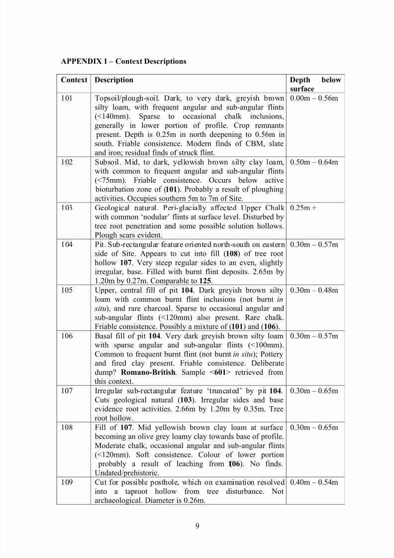
APPENDIX 1 – Context Descriptions
Context Description Depth belowsurface
101 Topsoil/plough-soil. Dark, to very dark, greyish brownsilty loam, with frequent angular and sub-angular flints(<140mm). Sparse to occasional chalk inclusions,generally in lower portion of profile. Crop remnants
present. Depth is 0.25m in north deepening to 0.56m insouth. Friable consistence. Modern finds of CBM, slateand iron; residual finds of struck flint.
0.00m – 0.56m
102 Subsoil. Mid, to dark, yellowish brown silty clay loam,with common to frequent angular and sub-angular flints(<75mm). Friable consistence. Occurs below active
bioturbation zone of ( 101 ). Probably a result of ploughingactivities. Occupies southern 5m to 7m of Site.
0.50m – 0.64m
103 Geological natural. Peri-glacially affected Upper Chalk with common ‘nodular’ flints at surface level. Disturbed bytree root penetration and some possible solution hollows.Plough scars evident.
0.25m +
104 Pit. Sub-rectangular feature oriented north-south on easternside of Site. Appears to cut into fill ( 108 ) of tree roothollow 107 . Very steep regular sides to an even, slightlyirregular, base. Filled with burnt flint deposits. 2.65m by1.20m by 0.27m. Comparable to 125 .
0.30m – 0.57m
105 Upper, central fill of pit 104 . Dark greyish brown siltyloam with common burnt flint inclusions (not burnt in situ ), and rare charcoal. Sparse to occasional angular andsub-angular flints (<120mm) also present. Rare chalk.Friable consistence. Possibly a mixture of ( 101 ) and ( 106 ).
0.30m – 0.48m
106 Basal fill of pit 104 . Very dark greyish brown silty loamwith sparse angular and sub-angular flints (<100mm).Common to frequent burnt flint (not burnt in situ ); Potteryand fired clay present. Friable consistence. Deliberatedump? Romano-British . Sample < 601 > retrieved fromthis context.
0.30m – 0.57m
107 Irregular sub-rectangular feature ‘truncated’ by pit 104 .Cuts geological natural ( 103 ). Irregular sides and baseevidence root activities. 2.66m by 1.20m by 0.35m. Treeroot hollow.
0.30m – 0.65m
108 Fill of 107 . Mid yellowish brown clay loam at surface becoming an olive grey loamy clay towards base of profile.Moderate chalk, occasional angular and sub-angular flints(<120mm). Soft consistence. Colour of lower portion
probably a result of leaching from ( 106 ). No finds.Undated/prehistoric.
0.30m – 0.65m
109 Cut for possible posthole, which on examination resolvedinto a taproot hollow from tree disturbance. Notarchaeological. Diameter is 0.26m.
0.40m – 0.54m
9
8/8/2019 Bigley Farm - Alvediston
http://slidepdf.com/reader/full/bigley-farm-alvediston 15/19
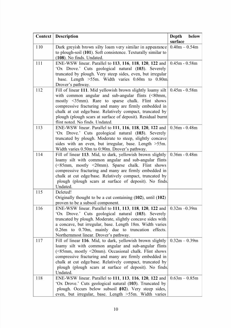
Context Description Depth belowsurface
110 Dark greyish brown silty loam very similar in appearanceto plough-soil ( 101 ). Soft consistence. Texturally similar to
(108 ). No finds. Undated.
0.40m – 0.54m
111 ENE-WSW linear. Parallel to 113 , 116 , 118 , 120 , 122 and‘Ox Drove.’ Cuts geological natural ( 103 ). Severelytruncated by plough. Very steep sides, even, but irregular
base. Length >55m. Width varies 0.60m to 0.80m.Drover’s pathway.
0.45m - 0.58m
112 Fill of linear 111 . Mid yellowish brown slightly loamy siltwith common angular and sub-angular flints (<80mm,mostly <35mm). Rare to sparse chalk. Flint showscompressive fracturing and many are firmly embedded inchalk at cut edge/base. Relatively compact, truncated by
plough (plough scars at surface of deposit). Residual burntflint noted. No finds. Undated.
0.45m - 0.58m
113 ENE-WSW linear. Parallel to 111 , 116 , 118 , 120 , 122 and‘Ox Drove.’ Cuts geological natural ( 103 ). Severelytruncated by plough. Moderate to steep, slightly concavesides with an even, but irregular, base. Length >55m.Width varies 0.50m to 0.90m. Drover’s pathway.
0.36m - 0.48m
114 Fill of linear 113 . Mid, to dark, yellowish brown slightlyloamy silt with common angular and sub-angular flints(<85mm, mostly <20mm). Sparse chalk. Flint shows
compressive fracturing and many are firmly embedded inchalk at cut edge/base. Relatively compact, truncated by plough (plough scars at surface of deposit). No finds.Undated.
0.36m - 0.48m
115 Deleted!Originally thought to be a cut containing ( 102 ), until ( 102 )
proven to be a subsoil component.116 ENE-WSW linear. Parallel to 111 , 113 , 118 , 120 , 122 and
‘Ox Drove.’ Cuts geological natural ( 103 ). Severelytruncated by plough. Moderate, slightly concave sides witha concave, but irregular, base. Length 18m. Width varies
0.26m to 0.70m, mainly due to truncation effects. Northernmost linear. Drover’s pathway.
0.32m –0.39m
117 Fill of linear 116 . Mid, to dark, yellowish brown slightlyloamy silt with common angular and sub-angular flints(<85mm, mostly <20mm). Occasional chalk. Flint showscompressive fracturing and many are firmly embedded inchalk at cut edge/base. Relatively compact, truncated by
plough (plough scars at surface of deposit). No finds.Undated.
0.32m – 0.39m
118 ENE-WSW linear. Parallel to 111 , 113 , 116 , 120 , 122 and‘Ox Drove.’ Cuts geological natural ( 103 ). Truncated by
plough. Occurs below subsoil ( 102 ). Very steep sides,even, but irregular, base. Length >55m. Width varies
0.63m – 0.85m
10
8/8/2019 Bigley Farm - Alvediston
http://slidepdf.com/reader/full/bigley-farm-alvediston 16/19
0.40m to 0.65m. Drover’s pathway.Context Description Depth below
surface119 Fill of linear 118 . Dark yellowish brown slightly loamy silt
with common angular and sub-angular flints (<55mm,mostly <20mm). Sparse chalk. Much flint showscompressive fracturing and many are firmly embedded inchalk at cut edge/base. Relatively compact, truncated by
plough (plough scars at surface of deposit). Residual findsof burnt and possible struck flints. No finds. Undated.
0.63m – 0.85m
120 ENE-WSW linear. Parallel to 111 , 113 , 116 , 118 , 122 and‘Ox Drove.’ Cuts geological natural ( 103 ). Truncated by
plough. Occurs below subsoil ( 102 ). Steep, concavenorthern edge, very steep, concave southern edge. Even,
but irregular, base. Length >55m. Width varies 0.30m to0.70m. Drover’s pathway.
0.70m – 0.96m
121 Fill of linear 120 . Mid, to dark, yellowish brown slightlyloamy silt with occasional angular and sub-angular flints(<60mm). Moderate to common chalk inclusions(<10mm). Some flint shows compressive fracturing andsome are firmly embedded in chalk at cut edge/base.Relatively compact, probably truncated by plough. Nofinds. Undated.
0.70m – 0.96m
122 ENE-WSW linear. Parallel to 111 , 113 , 116 , 118 , 120 and‘Ox Drove.’ Cuts geological natural ( 103 ). Possiblytruncated by plough. Occurs below subsoil ( 102 ).
Moderate, slightly concave, northern edge. Base andsouthern edge not encountered. Length >5m observed.Width averages 0.35m. Southernmost linear. Drover’s
pathway.
0.65m – 0.85m
123 Fill of linear 122 . Mid, to pale, yellowish brown slightlyloamy silt with sparse angular and sub-angular flints(<45mm). Common chalk inclusions (<5mm). Some flintshows compressive fracturing and a few are firmlyembedded in chalk at cut edge/base. Relatively compact,
probably truncated by plough. No finds. Undated.
0.65m – 0.85m
124 Fill of pit/tree throw hole 125 . Dark greyish brown silty
clay, with frequent angular and sub-angular flints(<100mm). Common burnt flint inclusions (not burnt in
situ ); fired clay and charcoal flecks also present. Fairlycompact. Undated, but may be contemporary with 104 .Sample < 602 > retrieved from this context.
0.30m – 0.51m
125 Pit/tree throw hole. Sub-rectangular feature oriented north-south on eastern side of Site. Sides and base are irregular.Cuts geological natural ( 103 ). Filled with burnt flintdeposit ( 124 ). 2.00m by 1.10m by 0.21m. Comparable to104 .
0.30m – 0.51m
11
8/8/2019 Bigley Farm - Alvediston
http://slidepdf.com/reader/full/bigley-farm-alvediston 17/19
8/8/2019 Bigley Farm - Alvediston
http://slidepdf.com/reader/full/bigley-farm-alvediston 18/19
Wessex
Archaeology
Date: Revision Number:Scale: Illustrator:
Path:
This material is for client report only © Wessex Archaeology. No unauthorised reproduction.
21/03/06 0
1:400 KJB
Y:\PROJECTS\62460\Drawing Office\Report Figures\WB\06-03-21
Site plan Figure 2
Natural
104
Natural
125
116
113
112118
120
122
114
117
112
119121
102
123
20m0 10
8/8/2019 Bigley Farm - Alvediston
http://slidepdf.com/reader/full/bigley-farm-alvediston 19/19