Embed Size (px)
Citation preview
___________________________________________________________________
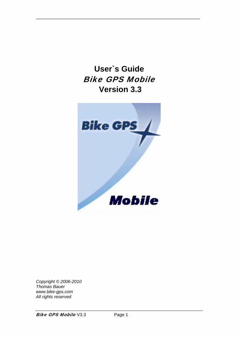
User`s Guide Bike GPS Mobile
Version 3.3
Copyright © 2006-2010 Thomas Bauer www.bike-gps.com All rights reserved
Bike GPS Mobile V3.3 Page 1
___________________________________________________________________
Introduction Bike GPS congratulates you to your choice of its navigation solution. The Bike GPS Mobile navigation solution was designed from Bikers for Bikers. We tried to fulfill high quality requirements and to transform our GPS (Global Positioning System) know how out of providing GPS tracks for cycling over years into this solution. With Bike GPS Mobile you will get a full-blown GPS solution that will give you comprehensive navigation support and security for biking but also for all other kind of outdoor activities. The main features of Bike GPS Mobile are:
1. Precise positioning via GPS (Latitude, Longitude, Altitude) 2. Track view in map style with track following capability 3. Displaying tracks and tours on topographical maps 4. Altitude view including your own position on the altitude profile 5. Cockpit with actual parameters like speed, odometer and altitude 6. Compass with track following capability 7. Recording of tracks 8. Import of Bike GPS tours and export of recorded tracks to different file
formats 9. Sending of GPS position via SMS 10. Satellites view
Bike GPS Mobile consists out of the following components:
• Bike GPS Mobile a Java based (J2ME – Java 2 Mobile Edition) application for mobile phones
• Bike GPS tours (Rich Track format) and other GPS tracks for import
• A Bluetooth GPS receiver a so called GPS mouse for Bike GPS Mobile. If your mobile phone has an integrated GPS receiver no external device is necessary.
Prerequisites All information regarding Bike GPS Mobile is located at www.bike-gps.com. You will find a list of supported mobile phones and GPS receivers. In addition you can download or order all different solution components of Bike GPS Mobile.
Bike GPS Mobile V3.3 Page 2
___________________________________________________________________
Installation Bike GPS Mobile will be delivered by 2 files (zipped together):
1. BikeGPS.jar 2. BikeGPS.jad
Please copy those files from your PC to your mobile phone via a Bluetooth connection or a data cable. Bike GPS Mobile has to be installed into a folder on your mobile phone where you are able to start Java applications e.g.:
/Data/Applications/BikeGPS
Alternatively the memory card of your mobile phone can be used by e.g.
e:/BikeGPSMobile
After copying the files of Bike GPS Mobile you are able to start the program directly or to initiate an installation on the mobile phone. You can also use the Nokia Application Installer to install Bike GPS Mobile on Nokia mobile phones. Hint: For the import and export of GPS tour and track files the folder “BikeGPS/“ is used by default. This folder is always located in the top level of the selected file system. Please note that this folder is usually not the same folder where the Bike GPS Mobile program files will be installed.
Alternatively you can install Bike GPS Mobile directly onto your mobile phone via a WAP connection. Please enter the following address into your WAP-Browser of your mobile phone:
http://www.biketransalp.de/wap
Version 3.2 (June 2010) of Bike GPS Mobile or higher is digitally signed with a Thawte security certificate. This prevents to change the program code in an unauthorized manner. In addition certified application have extended rights on mobile phones. For that reason security dialogs can be totally switched off which is necessary when loading stored map data from the external memory card. Mandatory requirement: The „Thawte Premium Server CA“ root certificate must be preinstalled on the mobile phone. Many phones and phone manufacturers are supporting Thawte certificates. Please check under settings -> security -> certificate management (or similar) if the Thawte root certificate is installed. If you can not find the Thawte root certificate on your mobile phone or if the installation of Bike GPS Mobile fails send us an email to [email protected] in order to get the unsigned version of Bike GPS Mobile. Even if you are using the certified version of Bike GPS Mobile you have to make sure after installation that Bike GPS Mobile is allowed to access your mobile phone resources like Bluetooth and data access. You can configure these properties by selecting the application icon of Bike GPS Mobile and using Options -> Application access -> Communication/Data access (example for Nokia S40 devices)
Bike GPS Mobile V3.3 Page 3
___________________________________________________________________
or by starting the program manager on your mobile phone (example for Nokia S60/Symbian devices). Please configure the following settings (minimum requirements for the unsigned version of Bike GPS Mobile, choose higher rights like „always allowed“, if possible): :
1. Network access – “ask first time only“ 2. Connectivity – “always allowed“ 3. Read user data – “ask every time“, better use “ask first time only“ (for caching
of maps on external memory card) 4. Edit user data – “ask every time“, better use “ask first time only“ (for caching
of maps on external memory card) 5. Positioning – “ask first time only” 6. On-Screen keyboard – “off“ (for Nokia touch screen phones only)
Bike GPS Mobile V3.3 Page 4
___________________________________________________________________
License Key You will need a license key for using all features of Bike GPS Mobile. You will get your personal key when purchasing by sending us your Bluetooth address of your mobile phone.
1. Please activate Bluetooth on your mobile phone (after configuration Bluetooth can be switched off on mobile phones with integrated GPS).
2. Please start Bike GPS Mobile on your mobile phone. For mobile phones with integrated GPS: If you are using an integrated GPS you have to acknowledge access to the internal GPS receiver. For mobile phones in combination with an external GPS receiver: You will get a message that no connection for your GPS device was configured yet. Please acknowledge this message by pressing “Ok“.
3. Choose “Settings“ and then “Connection“ from the main menu. 4. The Bluetooth address of your mobile phone will be listed as last menu
item in the menu “Connection”. Please send your Bluetooth address via email to Bike GPS ([email protected]). You will get your personal license key back.
5. Choose “License Key“. Please enter your license key and press “Save“. 6. Please continue setting up Bike GPS Mobile. If you are using an
integrated GPS no additional initial set up is necessary. Please keep in mind, that your license key is valid for your mobile phone only. Hint: In case you have not yet purchased a license for Bike GPS Mobile, it is possible to use Bike GPS Mobile with a limited feature set without entering a valid license key.
Initial Set Up After installation and entering your license key please proceed as follows to perform the initial set up of Bike GPS Mobile .
7. Switch on your Bluetooth GPS receiver (“GPS mouse”). 8. Choose “Connection“ and the “BT Device Search“. Your GPS Mouse
will be discovered and its Bluetooth Address will be stored. 9. Exit Bike GPS Mobile and restart again. By starting Bike GPS
Mobile the stored BT address will be used for setting up a data connection with your GPS mouse.
If you should have any trouble discovering your GPS mouse you can enter the BT address of your GPS mouse manually:
• Please choose “Connection“ and then “BT Address“ and enter the Bluetooth address of your GPS mouse. • Please choose “Save“. Exit and restart Bike GPS Mobile. By starting Bike GPS Mobile the stored BT address will be used for setting up a data connection with your GPS mouse.
Bike GPS Mobile V3.3 Page 5
___________________________________________________________________
Hint: It can be necessary to enter the Bluetooth pairing code e.g. 0000 or 1111 at startup of Bike GPS Mobile! In case of loosing the Bluetooth connection Bike GPS Mobile will try continuously to set up a new connection.
Bike GPS Mobile V3.3 Page 6
___________________________________________________________________
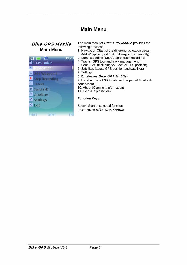
Main Menu
Bike GPS Mobile Main Menu
The main menu of Bike GPS Mobile provides the following functions: 1. Navigation (Start of the different navigation views) 2. Add Waypoint (add and edit waypoints manually) 3. Start Recording (Start/Stop of track recording) 4. Tracks (GPS tour and track management) 5. Send SMS (including your actual GPS position) 6. Satellites (actual GPS position and satellites) 7. Settings 8. Exit (leaves Bike GPS Mobile) 9. Log (Logging of GPS data and reopen of Bluetooth connection) 10. About (Copyright information) 11. Help (Help function) Function Keys Select: Start of selected function Exit: Leaves Bike GPS Mobile
Bike GPS Mobile V3.3 Page 7
___________________________________________________________________
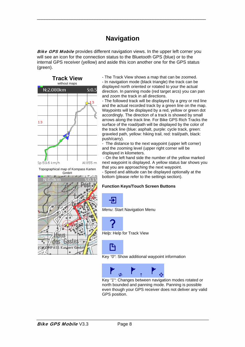
Navigation Bike GPS Mobile provides different navigation views. In the upper left corner you will see an icon for the connection status to the Bluetooth GPS (blue) or to the internal GPS receiver (yellow) and aside this icon another one for the GPS status (green).
Track View without maps
Topographical map of Kompass Karten
GmbH
- The Track View shows a map that can be zoomed. - In navigation mode (black triangle) the track can be displayed north oriented or rotated to your the actual direction. In panning mode (red target arcs) you can pan and zoom the track in all directions. - The followed track will be displayed by a grey or red line and the actual recorded track by a green line on the map. Waypoints will be displayed by a red, yellow or green dot accordingly. The direction of a track is showed by small arrows along the track line. For Bike GPS Rich Tracks the surface of the road/path will be displayed by the color of the track line (blue: asphalt, purple: cycle track, green: graveled path, yellow: hiking trail, red: trail/path, black: push/carry). - The distance to the next waypoint (upper left corner) and the zooming level (upper right corner will be displayed in kilometers. - On the left hand side the number of the yellow marked next waypoint is displayed. A yellow status bar shows you that you are approaching the next waypoint. - Speed and altitude can be displayed optionally at the bottom (please refer to the settings section). Function Keys/Touch Screen Buttons
Menu: Start Navigation Menu
Help: Help for Track View
Key “0“: Show additional waypoint information
Key “1“: Changes between navigation modes rotated or north bounded and panning mode. Panning is possible even though your GPS receiver does not deliver any valid GPS position.
Bike GPS Mobile V3.3 Page 8
___________________________________________________________________
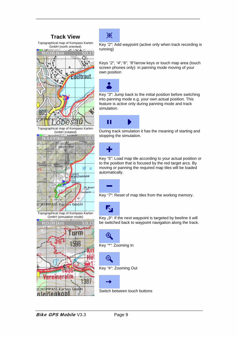
Track View Topographical map of Kompass Karten
GmbH (north oriented)
Topographical map of Kompass Karten
GmbH (rotated)
Topographical map of Kompass Karten
GmbH (simulation mode)
Key “2“: Add waypoint (active only when track recording is running) Keys “2“, “4“,“6“, “8“/arrow keys or touch map area (touch screen phones only): in panning mode moving of your own position
Key “3”: Jump back to the initial position before switching into panning mode e.g. your own actual position. This feature is active only during panning mode and track simulation.
During track simulation it has the meaning of starting and stopping the simulation.
Key “5”: Load map tile according to your actual position or to the position that is focused by the red target arcs. By moving or panning the required map tiles will be loaded automatically.
Key “7“: Reset of map tiles from the working memory.
Key „9“: If the next waypoint is targeted by beeline it will be switched back to waypoint navigation along the track.
Key “*“: Zooming In
Key “#“: Zooming Out
Switch between touch buttons
Bike GPS Mobile V3.3 Page 9
___________________________________________________________________
Hint: All map data is provided by a mobile Internet service (including the well known topological maps of Kompass Karten GmbH). Please be aware of any mobile network charges by your network provider which may incur using Bike GPS Mobile for any amount of data, SMS or network airtime! Bike GPS endeavors to provide topographical maps of different vendors and with large geographic coverage. Please check our FAQ (Frequently Asked Question) for actual information about supported maps at www.bike-gps.com.
Bike GPS Mobile V3.3 Page 10
___________________________________________________________________
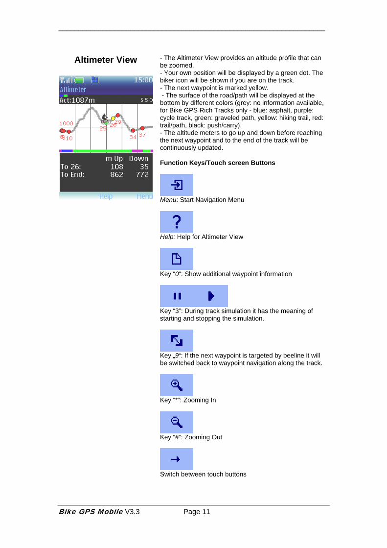
Altimeter View
- The Altimeter View provides an altitude profile that can be zoomed. - Your own position will be displayed by a green dot. The biker icon will be shown if you are on the track. - The next waypoint is marked yellow. - The surface of the road/path will be displayed at the bottom by different colors (grey: no information available, for Bike GPS Rich Tracks only - blue: asphalt, purple: cycle track, green: graveled path, yellow: hiking trail, red: trail/path, black: push/carry). - The altitude meters to go up and down before reaching the next waypoint and to the end of the track will be continuously updated. Function Keys/Touch screen Buttons
Menu: Start Navigation Menu
Help: Help for Altimeter View
Key “0“: Show additional waypoint information
Key “3”: During track simulation it has the meaning of starting and stopping the simulation.
Key „9“: If the next waypoint is targeted by beeline it will be switched back to waypoint navigation along the track.
Key “*“: Zooming In
Key “#“: Zooming Out
Switch between touch buttons
Bike GPS Mobile V3.3 Page 11
___________________________________________________________________
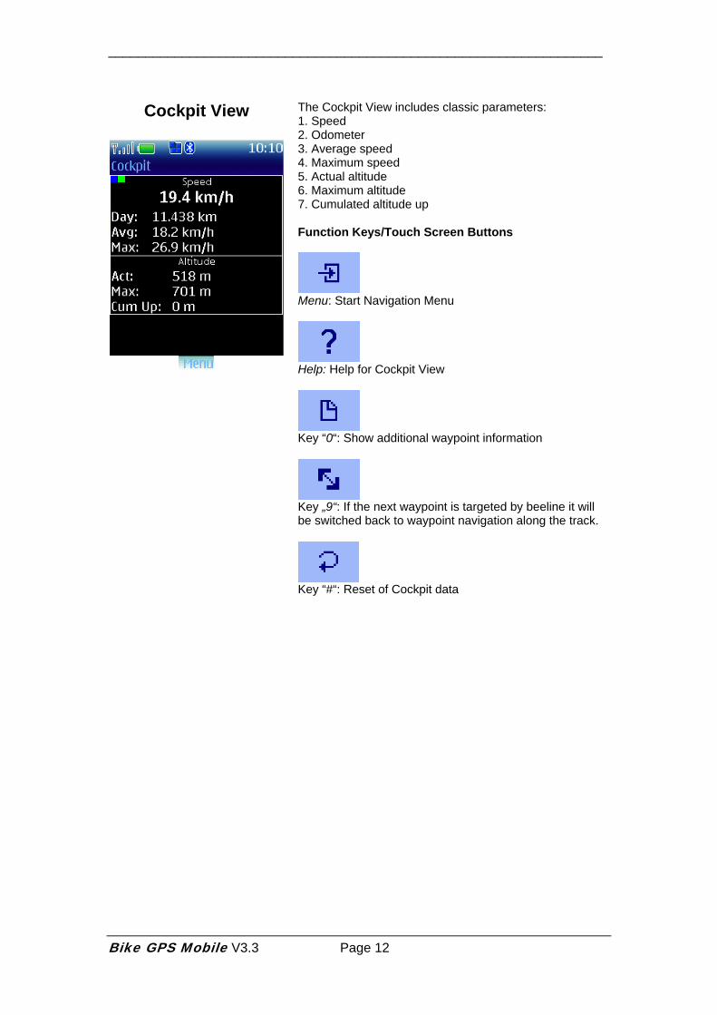
Cockpit View
The Cockpit View includes classic parameters: 1. Speed 2. Odometer 3. Average speed 4. Maximum speed 5. Actual altitude 6. Maximum altitude 7. Cumulated altitude up Function Keys/Touch Screen Buttons
Menu: Start Navigation Menu
Help: Help for Cockpit View
Key “0“: Show additional waypoint information
Key „9“: If the next waypoint is targeted by beeline it will be switched back to waypoint navigation along the track.
Key “#“: Reset of Cockpit data
Bike GPS Mobile V3.3 Page 12
___________________________________________________________________
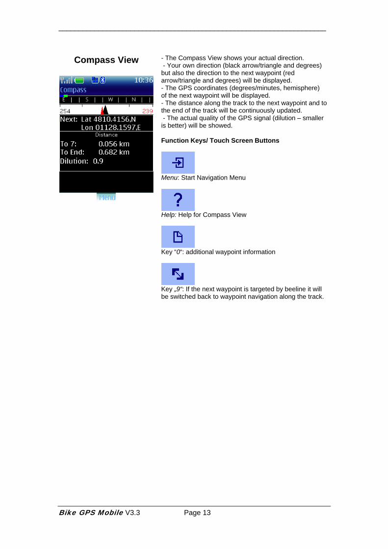
Compass View
- The Compass View shows your actual direction. - Your own direction (black arrow/triangle and degrees) but also the direction to the next waypoint (red arrow/triangle and degrees) will be displayed. - The GPS coordinates (degrees/minutes, hemisphere) of the next waypoint will be displayed. - The distance along the track to the next waypoint and to the end of the track will be continuously updated. - The actual quality of the GPS signal (dilution – smaller is better) will be showed. Function Keys/ Touch Screen Buttons
Menu: Start Navigation Menu
Help: Help for Compass View
Key “0“: additional waypoint information
Key „9“: If the next waypoint is targeted by beeline it will be switched back to waypoint navigation along the track.
Bike GPS Mobile V3.3 Page 13
___________________________________________________________________
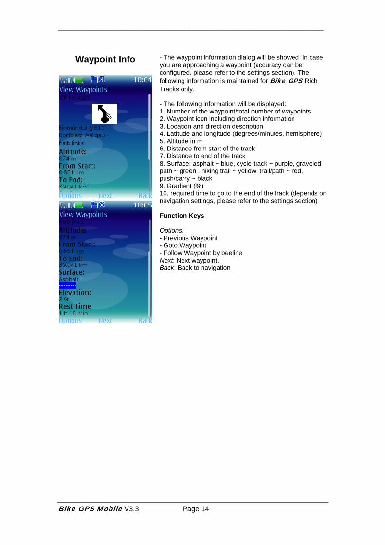
Waypoint Info
- The waypoint information dialog will be showed in case you are approaching a waypoint (accuracy can be configured, please refer to the settings section). The following information is maintained for Bike GPS Rich Tracks only. - The following information will be displayed: 1. Number of the waypoint/total number of waypoints 2. Waypoint icon including direction information 3. Location and direction description 4. Latitude and longitude (degrees/minutes, hemisphere) 5. Altitude in m 6. Distance from start of the track 7. Distance to end of the track 8. Surface: asphalt ~ blue, cycle track ~ purple, graveled path ~ green , hiking trail ~ yellow, trail/path ~ red, push/carry ~ black 9. Gradient (%) 10. required time to go to the end of the track (depends on navigation settings, please refer to the settings section) Function Keys Options: - Previous Waypoint - Goto Waypoint - Follow Waypoint by beeline Next: Next waypoint. Back: Back to navigation
Bike GPS Mobile V3.3 Page 14
___________________________________________________________________
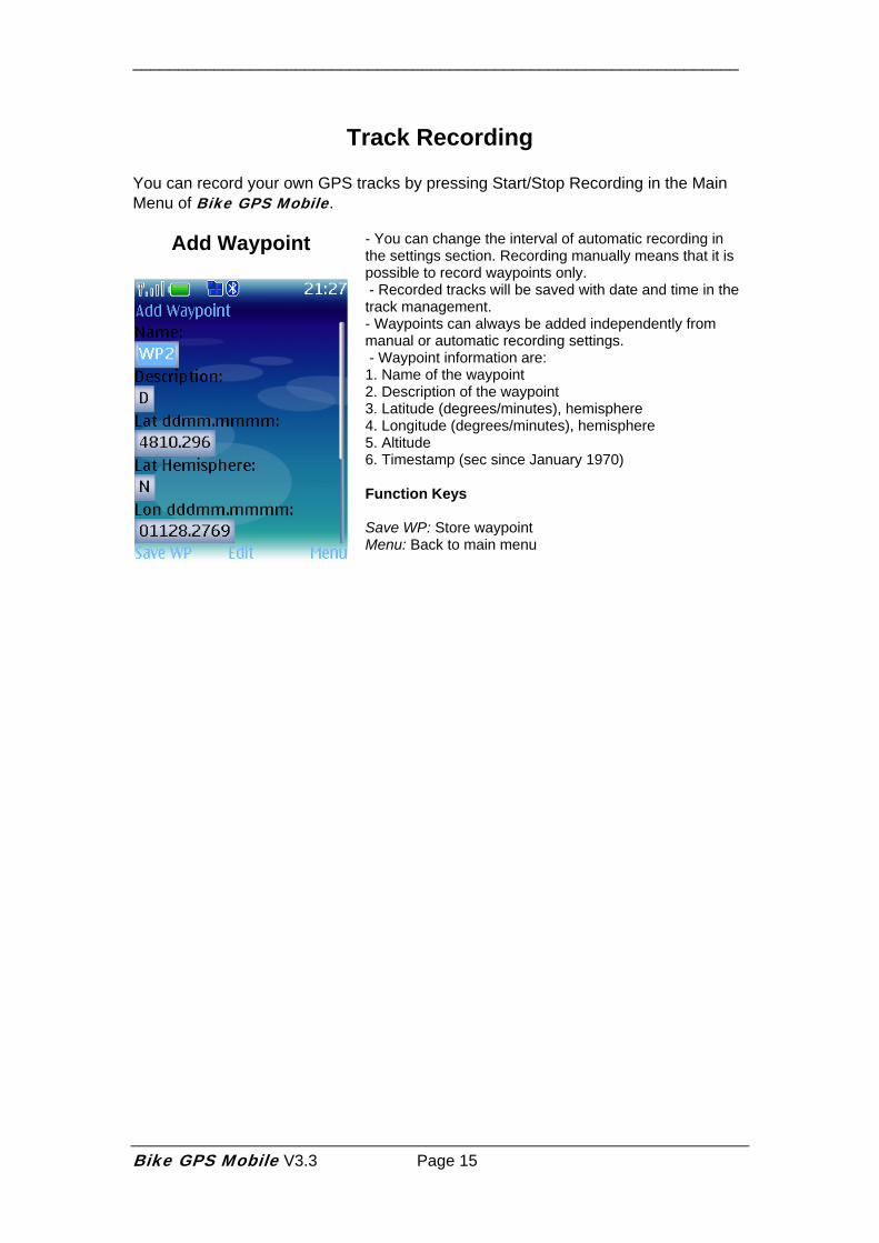
Track Recording You can record your own GPS tracks by pressing Start/Stop Recording in the Main Menu of Bike GPS Mobile.
Add Waypoint
- You can change the interval of automatic recording in the settings section. Recording manually means that it is possible to record waypoints only. - Recorded tracks will be saved with date and time in the track management. - Waypoints can always be added independently from manual or automatic recording settings. - Waypoint information are: 1. Name of the waypoint 2. Description of the waypoint 3. Latitude (degrees/minutes), hemisphere 4. Longitude (degrees/minutes), hemisphere 5. Altitude 6. Timestamp (sec since January 1970) Function Keys Save WP: Store waypoint Menu: Back to main menu
Bike GPS Mobile V3.3 Page 15
___________________________________________________________________
Track Management
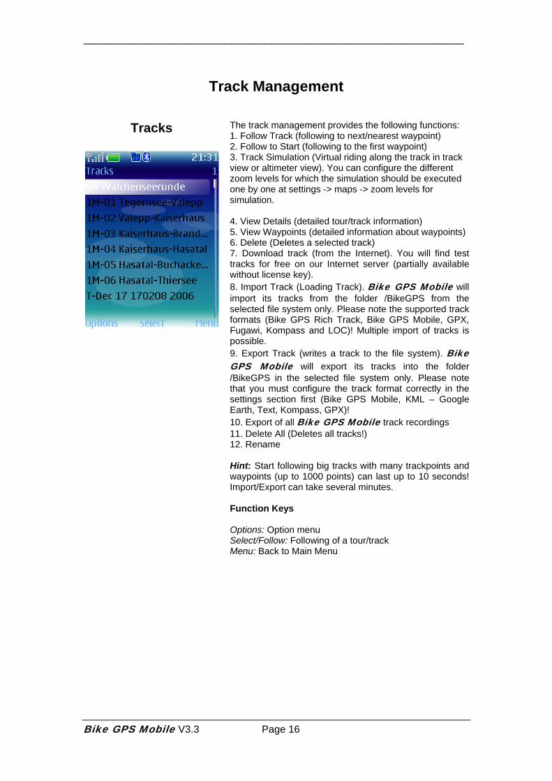
Tracks
The track management provides the following functions: 1. Follow Track (following to next/nearest waypoint) 2. Follow to Start (following to the first waypoint) 3. Track Simulation (Virtual riding along the track in track view or altimeter view). You can configure the different zoom levels for which the simulation should be executed one by one at settings -> maps -> zoom levels for simulation. 4. View Details (detailed tour/track information) 5. View Waypoints (detailed information about waypoints) 6. Delete (Deletes a selected track) 7. Download track (from the Internet). You will find test tracks for free on our Internet server (partially available without license key). 8. Import Track (Loading Track). Bike GPS Mobile will import its tracks from the folder /BikeGPS from the selected file system only. Please note the supported track formats (Bike GPS Rich Track, Bike GPS Mobile, GPX, Fugawi, Kompass and LOC)! Multiple import of tracks is possible. 9. Export Track (writes a track to the file system). Bike GPS Mobile will export its tracks into the folder /BikeGPS in the selected file system only. Please note that you must configure the track format correctly in the settings section first (Bike GPS Mobile, KML – Google Earth, Text, Kompass, GPX)! 10. Export of all Bike GPS Mobile track recordings 11. Delete All (Deletes all tracks!) 12. Rename Hint: Start following big tracks with many trackpoints and waypoints (up to 1000 points) can last up to 10 seconds! Import/Export can take several minutes. Function Keys Options: Option menu Select/Follow: Following of a tour/track Menu: Back to Main Menu
Bike GPS Mobile V3.3 Page 16
___________________________________________________________________
Track Management
Track Details
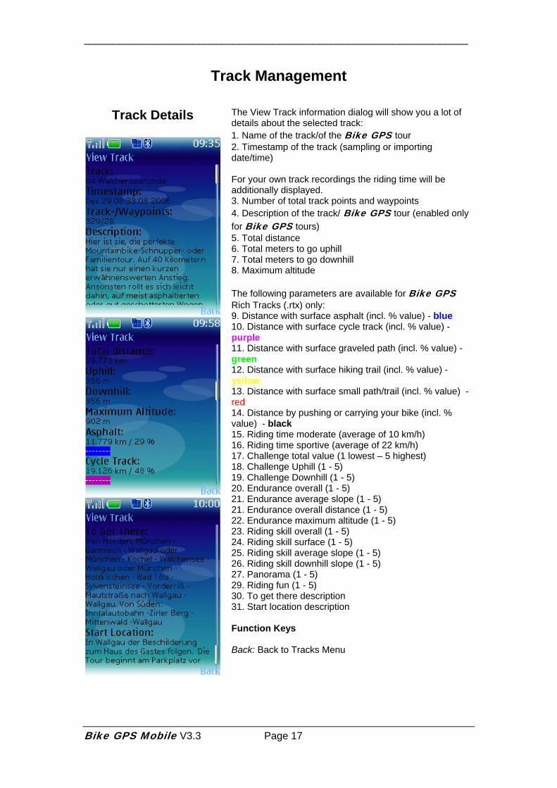
The View Track information dialog will show you a lot of details about the selected track: 1. Name of the track/of the Bike GPS tour 2. Timestamp of the track (sampling or importing date/time) For your own track recordings the riding time will be additionally displayed. 3. Number of total track points and waypoints 4. Description of the track/ Bike GPS tour (enabled only for Bike GPS tours) 5. Total distance 6. Total meters to go uphill 7. Total meters to go downhill 8. Maximum altitude The following parameters are available for Bike GPS Rich Tracks (.rtx) only: 9. Distance with surface asphalt (incl. % value) - blue 10. Distance with surface cycle track (incl. % value) - purple 11. Distance with surface graveled path (incl. % value) - green 12. Distance with surface hiking trail (incl. % value) - yellow 13. Distance with surface small path/trail (incl. % value) - red 14. Distance by pushing or carrying your bike (incl. % value) - black 15. Riding time moderate (average of 10 km/h) 16. Riding time sportive (average of 22 km/h) 17. Challenge total value (1 lowest – 5 highest) 18. Challenge Uphill (1 - 5) 19. Challenge Downhill (1 - 5) 20. Endurance overall (1 - 5) 21. Endurance average slope (1 - 5) 21. Endurance overall distance (1 - 5) 22. Endurance maximum altitude (1 - 5) 23. Riding skill overall (1 - 5) 24. Riding skill surface (1 - 5) 25. Riding skill average slope (1 - 5) 26. Riding skill downhill slope (1 - 5) 27. Panorama (1 - 5) 29. Riding fun (1 - 5) 30. To get there description 31. Start location description Function Keys Back: Back to Tracks Menu
Bike GPS Mobile V3.3 Page 17
___________________________________________________________________
Send SMS
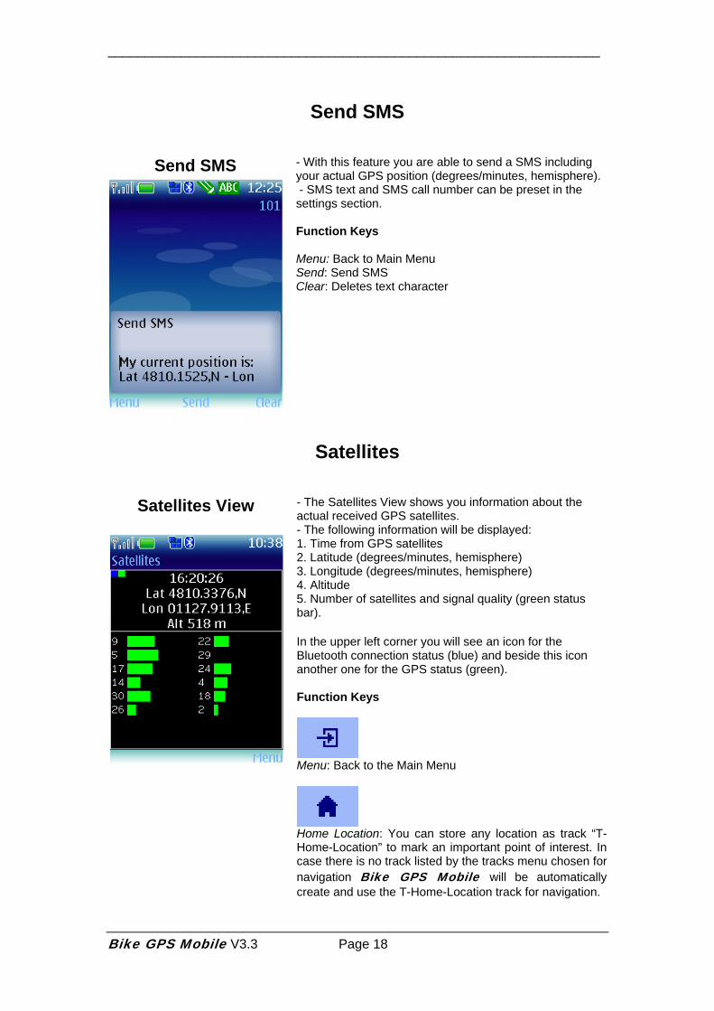
Send SMS
- With this feature you are able to send a SMS including your actual GPS position (degrees/minutes, hemisphere). - SMS text and SMS call number can be preset in the settings section. Function Keys Menu: Back to Main Menu Send: Send SMS Clear: Deletes text character
Satellites
Satellites View
- The Satellites View shows you information about the actual received GPS satellites. - The following information will be displayed: 1. Time from GPS satellites 2. Latitude (degrees/minutes, hemisphere) 3. Longitude (degrees/minutes, hemisphere) 4. Altitude 5. Number of satellites and signal quality (green status bar). In the upper left corner you will see an icon for the Bluetooth connection status (blue) and beside this icon another one for the GPS status (green). Function Keys
Menu: Back to the Main Menu
Home Location: You can store any location as track “T-Home-Location” to mark an important point of interest. In case there is no track listed by the tracks menu chosen for navigation Bike GPS Mobile will be automatically create and use the T-Home-Location track for navigation.
Bike GPS Mobile V3.3 Page 18
___________________________________________________________________
Settings
Settings
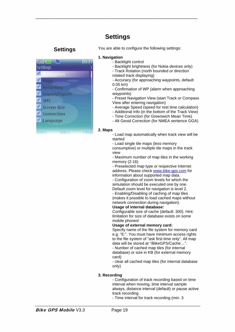
You are able to configure the following settings: 1. Navigation
- Backlight control - Backlight brightness (for Nokia devices only) - Track Rotation (north bounded or direction rotated track displaying) - Accuracy (for approaching waypoints, default 0.05 km) - Confirmation of WP (alarm when approaching waypoints) - Preset Navigation View (start Track or Compass View after entering navigation) - Average Speed (speed for rest time calculation) - Additional Info (in the bottom of the Track View) - Time Correction (for Greenwich Mean Time) - Alt Geoid Correction (for NMEA sentence GGA)
2. Maps
- Load map automatically when track view will be started - Load single tile maps (less memory consumptive) or multiple tile maps in the track view - Maximum number of map tiles in the working memory (2-16) - Preselected map type or respective Internet address. Please check www.bike-gps.com for information about supported map data. - Configuration of zoom levels for which the simulation should be executed one by one. Default zoom level for navigation is level 2. - Enabling/Disabling of caching of map tiles (makes it possible to load cached maps without network connection during navigation). Usage of internal database: Configurable size of cache (default: 300). Hint: limitation for size of database exists on some mobile phones! Usage of external memory card: Specify name of the file system for memory card e.g. “E:”. You must have minimum access rights to the file system of “ask first time only”. All map data will be stored at “/BikeGPS/Cache…”. - Number of cached map tiles (for internal database) or size in KB (for external memory card) - clear all cached map tiles (for internal database only)
3. Recording - Configuration of track recording based on time interval when moving, time interval sample always, distance interval (default) or pause active track recording - Time interval for track recording (min. 3
Bike GPS Mobile V3.3 Page 19
___________________________________________________________________
seconds, default 8 seconds) - Distance interval for track recording (default 50m) - automatic start of track recording by following of a track - Manual (waypoints only) or automatic track recording (trackpoints and waypoints), (Restart necessary!) - Live Tracking with Leonardo Live (www.livetrack24.com). A registration at Leonardo Live is needed. Depending on the type of confirmation when stopping track recording you are able to configure notifications by email, SMS at Leonardo Live e.g. in case of emergency. 1. Enabling of Live Tracking/Frequency of positions to be send during track recording. Please be aware of any mobile network charges by your network provider which may incur using Bike GPS Mobile for data transmission! 2. Live Tracking User Name 3. Live Tracking Password 4. Live Tracking Sports (Hiking, Running, Biking) 5. Live Tracking Sports Equipment (free description) 6. Number of positions successfully sent 7. Number of position which could not be sent - Maximum size of a track (non-editable, depends on mobile phone resources)
4. Import/Export
Import (supported file formats will be recognized automatically): - GPX (import of trackpoints and waypoints) - BikeGPS (internal format, import of Bike GPS Rich Tracks, .rtx) - Fugawi (import from Fugawi.txt, file format: <Latitude>,<Longitude>,<Altitude>,<optional not imported parameters>...) - Kompass (import from Kompass.tk, file format: <Latitude>,<Longitude>,<optional parsed Altitude>) - LOC (import of single waypoints e.g. Geocaches) Export: - GPX export of trackpoints and waypoints for usage as import file to other programs. - BikeGPS (internal format, export of recorded tracks) contains track name, description and timestamp, trackpoint or waypoint name (starting with WP...), latitude and longitude, altitude, timestamp, waypoint description - Fugawi (export to comma separated text) contains latitude, longitude, altitude, date, time, speed, track or waypoint name, waypoint description. 2 files will be generated (track and route) which can be imported in the Fugawi PC software. - Kompass (export to comma separated text) contains latitude, longitude, altitude. Works as
Bike GPS Mobile V3.3 Page 20
___________________________________________________________________
Kompass digital maps and Fugawi PC import file. - KML Google Earth export with trackpoints and waypoints (for Google Earth viewer) - Preset File System (preselected file system on your mobile phone e.g. multimedia card, internal file system) - automatic reduction of GPX/Rich Tracks points (approx. distance of 50m) - Activate/ Deactivate UTF-8 character set for GPX/Rich Track format - Bike GPS portal (www.bike-gps.com) user name (email address) for tour download (currently no usage by Bike GPS Mobile!) - Bike GPS portal password (currently no usage by Bike GPS Mobile!) - Path Prefix configures path for file system access e.g. “Other“ for access to
“e:/Other/BikeGPS/file.bgt“
(“BikeGPS/“ is preset by default). Necessary! for Sony Ericsson mobile phones K320, M600, P990. - Maximum size of a track (non-editable, depends on mobile phone resources)
Hint: For file system access on some mobile phones please configure the read and write access to the internal file system (C:) or the multimedia card (E:) by editing the program properties of Bike GPS Mobile after installation (e.g. by Nokia program manager). Please also check the installation section!
5. SMS
- Standard Destination Number - Standard Text
6. Screen Size
- The road surface can be displayed by color of track line (for RTX tracks only) or explicit setting of track color (for map mode only), please refer to section track management) - Size of track line and waypoints - Number of segments in the track view to the horizon - Size of different Navigation views and Satellites View
7. Connection
- Connection type for internal or Bluetooth GPS (relevant only for mobile phones with integrated GPS receiver) - BT Device Search (searches for GPS mouse) - GPS BT Address (entering GPS BT address manually) - License Key - “BT:…” own Bluetooth address of your mobile phone. Relevant for license key generation.
Bike GPS Mobile V3.3 Page 21
___________________________________________________________________
8. Language selection
- Selection of Englisch, German or Italian language (restart necessary!)
Function Keys Select/S: Start of selected function Menu: Back to the Main Menu
Bike GPS Mobile V3.3 Page 22
___________________________________________________________________
Bike GPS Mobile V3.3 Page 23
Bike GPS Mobile Terms of Use and License, Copyright, Non Liability and Trademarks The copyright of all material published by the author remains at the author solely. Copying or usage of any graphics, audio, video, text or software content is not allowed in any form without explicit permission by the author. Unless the prior written consent of the author, it is not permitted to modify, adapt, translate, prepare derivative works from, decompile, reverse engineer the Bike GPS Mobile software or otherwise attempt to derive source code of Bike GPS Mobile. The author of Bike GPS Mobile gives no warranty that any provided information or software is actual, correct, complete or that any kind of quality is ensured for Bike GPS Mobile. Liabilities against the author or against Bike GPS for any personally, materially or ideally damage are excluded independently from using or not using the provided information or software and also in all cases where the information or the software is incomplete or incorrect. In addition all personal or material damages which are related to the usage of Bike GPS Mobile in combination with mobile phones or GPS receivers or other items are excluded. The user of confirms that he has the sole responsibility and waves any claim against the author or Bike GPS to pay any mobile network charges which may incur using Bike GPS Mobile for any amount of data, SMS or network airtime. Bike GPS is not liable for any information or personal data that might be exchanged over the mobile network or Internet or otherwise by using Bike GPS Mobile. Any information or data relating to Bike GPS Mobile that is send to Bike GPS without further purpose can be used commercially or non-commercially or can be copied, modified, passed or make publicly available by Bike GPS. To the purchaser of a Bike GPS Mobile license key Bike GPS grants a non-transferable, to the release and functionality of Bike GPS Mobile as of the date of purchase linked license to use Bike GPS Mobile. The license key is bounded to the mobile phone for which Bike GPS has generated the respective license key. The purchaser of the license key explicitly agrees that in no event the license for usage of Bike GPS Mobile can be transferred to another mobile phone. All trademarks listed by Bike GPS might be protected by third parties and have to fulfill all requirements of the respective trademark law. Listing of trademarks into this user guide will not suspend in any case any existing trademark protection. © 2006-2010 Thomas Bauer, All Rights reserved. Java, J2ME are trademarks or registered trademarks of Sun Microsystems Corporation Google is a trademark of Google Corporation BenQ-SIEMENS is a registered trademark of BenQ Corporation Nokia is a registered trademark of Nokia OYJ Sony Ericsson is a registered trademark of Sony Ericsson Mobile Communications AB SIEMENS is a registered trademark of Siemens AG. Copyright (c) 2000-2007 The Legion Of The Bouncy Castle (http://www.bouncycastle.org) Copyright (c) 2002-2007 Stefan Haustein, Oberhausen, Rhld., Germany (http://www.kobjects.org/kxml/) XmlPull parser: Stefan Haustein and Aleksander Slominski (http://www.xmlpull.org) Permission is hereby granted, free of charge, to any person obtaining a copy of this software and associated documentation files (the "Software"), to deal in the Software without restriction, including without limitation the rights to use, copy, modify, merge, publish, distribute, sublicense, and/or sell copies of the Software, and to permit persons to whom the Software is furnished to do so, subject to the following conditions: The above copyright notice and this permission notice shall be included in all copies or substantial portions of the Software. THE SOFTWARE IS PROVIDED "AS IS", WITHOUT WARRANTY OF ANY KIND, EXPRESS OR IMPLIED, INCLUDING BUT NOT LIMITED TO THE WARRANTIES OF MERCHANTABILITY, FITNESS FOR A PARTICULAR PURPOSE AND NONINFRINGEMENT. IN NO EVENT SHALL THE AUTHORS OR COPYRIGHT HOLDERS BE LIABLE FOR ANY CLAIM, DAMAGES OR OTHER LIABILITY, WHETHER IN AN ACTION OF CONTRACT, TORT OR OTHERWISE, ARISING FROM, OUT OF OR IN CONNECTION WITH THE SOFTWARE OR THE USE OR OTHER DEALINGS IN THE SOFTWARE.
All other products are trademarks or registered trademarks of the respective holders.