Embed Size (px)
Citation preview


BILLINGS AIRPORT ROAD AND MAIN STREET CONCEPT STUDYSeptember 2016
Project Description: Airport Rd & Main St – BillingsProject Number: CM 1099(102) Uniform Project NO. 8718000Highway: Intersection N-16 (Main St) and U1014 (Airport Rd)County: YellowstoneShort Description: Traffic Study (Phase 1)Design Standards: Urban
Prepared for: Montana Department of Transportation
2701 Prospect AveHelena, MT 59601
Prepared by: Kittelson & Associates, Inc.
101 S Capitol Blvd, Suite 301 Boise, ID 83702
IBILLINGS AIRPORT ROAD AND MAIN STREET CONCEPT STUDY
PREFACEThe Airport Road & Main Street Concept Study was developed under the guidance of the Project Advisory Committee (PAC). PAC members are identified below, along with members of the consultant team. The PAC was responsible for reviewing all work products, providing direction for the project, assisting with the Public Informational Meeting (PIM), and making recommendations on the study. The PAC included representatives from MDT, Yellowstone County, City of Billings, and the Federal Highway Administration (FHWA). Thank you to the following PAC members for their instrumental involvement with the development of the Airport Road & Main Street Concept Study.
PROJECT ADVISORY COMMITTEEWade Salyards, Montana Department of Transportation
Danielle Bolan, Montana Department of Transportation
Stefan Streeter, Montana Department of Transportation
Gary Neville, Montana Department of Transportation
Stanton Brelin, Montana Department of Transportation
Tasha King, Montana Department of Transportation
Stan Jonutis, Montana Department of Transportation
Mike Black, Yellowstone County
Tim Miller, Yellowstone County
Terry Smith, City of Billings
Debi Meling, City of Billings
Scott Walker, City of Billings-Yellowstone County
Alan Woodmansey, Federal Highway Administration
CONSULTANT TEAMKittelson & Associates, Inc.Scott Beaird, PE – Project Principal
Andy Daleiden, PE – Project Manager
Brett Korporaal – Project Analyst/Designer
Yuri Mereszczak, PE – Technical Resource
Robyn Austin – Public Involvement Specialist
A special thanks to the Policy Coordinating Committee for listening to our study updates, providing insights on the study, and attending the PIM.
A final thank you to the public that provided information, comments, suggestions, or their valuable time during the planning process.
BILLINGS AIRPORT ROAD AND MAIN STREET CONCEPT STUDY
II
SUPPORTING DOCUMENTATIONTechnical memoranda were developed to summarize analyses, evaluations, and concept designs throughout the project. The technical memoranda were prepared in coordination with the PAC through four meetings and in preparation of the PIM. Data and information from those documents are referenced throughout the report, and can be found in the Technical Appendix and digitally filed at MDT. Documents and reports developed as part of the study include:
• Technical Memorandum #1: Existing and Future Transportation Conditions
• Technical Memorandum: Environmental Scan
• Technical Memorandum #2: Evaluation Criteria and Initial Alternatives
• Technical Memorandum #3A: Tier I: Evaluation and Screening of Initial Alternatives
• Technical Memorandum #3B: Tier II: Selection of a Preferred Alternative
• PAC Meeting Summaries
• Public Informational Meeting Summary
• Final Planning Level Cost Estimates
The Technical Appendix is a separate document and can be accessed through MDT.
IIIBILLINGS AIRPORT ROAD AND MAIN STREET CONCEPT STUDY
Table of ContentsIntroduction ................................................................................................................................ 3
Study Area ........................................................................................................................................... 3Study Process ..................................................................................................................................... 3Past Studies and Plans .................................................................................................................... 5Study Purpose and Need ............................................................................................................... 5Goals, Objectives, and Evaluation Criteria ............................................................................... 6
Interagency and Public Involvement Program ............................................................................ 11Overall Plan ..........................................................................................................................................11Project Advisory Committee ........................................................................................................11Public Outreach ..................................................................................................................................11
Background .............................................................................................................................. 16Existing Conditions ..........................................................................................................................16Future Year 2040 Conditions .....................................................................................................27
Alternatives Development and Evaluation ................................................................................. 33Tier I – Initial Alternatives and Evaluation ..............................................................................33Tier II – Refined Alternatives and Evaluation ........................................................................37Tier III – Recommended Alternatives ...................................................................................... 50
Recommended Alternative and Implementation ....................................................................... 61Other Improvements ......................................................................................................................62Recommendation and Implementation ..................................................................................62
BILLINGS AIRPORT ROAD AND MAIN STREET CONCEPT STUDY
IV
List of ExhibitsExhibit 1. Study Process ............................................................................................................... 3
Exhibit 2. Online Interactive Map Survey ................................................................................... 12
Exhibit 3. Newsletters to Community and Property Owners ....................................................... 12
Exhibit 4. Billings Gazette News Release .................................................................................... 13
Exhibit 5. Public Informational Meeting ..................................................................................... 14
Exhibit 6. Existing Zoning Map ................................................................................................... 16
Exhibit 7. Existing Roadway Facilities Map ................................................................................. 18
Exhibit 8. Hourly AADT Profile at Main Street North of 1st Avenue ............................................ 19
Exhibit 9. Total Entering Volume Comparison of Event and Non-Event Traffic at the Airport Road/Main Street Intersection ................................................................................... 25
Exhibit 10. Crash Data at Lake Elmo Drive/Main Street Intersection ........................................... 26
Exhibit 11. Crash Data at Airport Road/Main Street Intersection ................................................ 26
Exhibit 12. Alternatives Development & Evaluation Process ....................................................... 33
Exhibit 13. Alternative 3B PM Peak Hour VISSIM Model ............................................................ 53
Exhibit 14. Alternative 5B PM Peak Hour VISSIM Model ............................................................ 54
Exhibit 15. Comment Summary of Support or No Support for the Three Alternatives................. 55
VBILLINGS AIRPORT ROAD AND MAIN STREET CONCEPT STUDY
List of FiguresFigure 1. Study Area Map ............................................................................................................ 4
Figure 2. Existing Lane Configurations and Traffic Control Devices .............................................. 21
Figure 3. Existing Conditions Weekday AM Peak Hour ................................................................ 22
Figure 4. Existing Conditions Weekday PM Peak Hour ................................................................ 23
Figure 5. Future Conditions Year 2040 AM Peak Hour ................................................................ 29
Figure 6. Future Conditions Year 2040 PM Peak Hour ................................................................. 30
Figure 7. Alternative 1 - No-Build Design Concept ...................................................................... 39
Figure 8. Alternative 2D - Dual Eastbound Left-Turn Lanes and Signal Phasing Modification Design Concept ....................................................................................................................... 40
Figure 9. Alternative 2E - Triple Eastbound Left-Turn Lanes and Signal Phasing Modification Design Concept ....................................................................................................................... 41
Figure 10. Alternative 3B - Signalized Southwest Quadrant Design Concept ............................... 42
Figure 11. Alternative 4B - Signalized Southwest Quandrant (One-Way Eastbound on E Airport Rd) Design Concept ....................................................................................................................... 43
Figure 12. Alternative 5A - Median U-Turn (North and South) Design Concept ........................... 44
Figure 13. Alternative 5B - Partial Displaced Left-Turn (Southwest Quadrant) Design Concept .... 45
Figure 14. Alternative 3B Refined Concept Design ...................................................................... 51
Figure 15. Alternative 5B Refined Concept Design ...................................................................... 52
Figure 16. Recommended Alternative 3B - Signalized Southwest Quadrant Design Concept ....... 63
BILLINGS AIRPORT ROAD AND MAIN STREET CONCEPT STUDY
VI
List of TablesTable 1. Summary of Past Studies and Plans ................................................................................ 4
Table 2. Goals, Objectives and Evaluation Criteria for Screening Alternatives ............................... 6
Table 3. PIM Open House Schedule ............................................................................................ 14
Table 4. Existing Roadway Characteristics .................................................................................. 18
Table 5. Pedestrian and Bicyclist Activity ................................................................................... 20
Table 6. Heavy Vehicle Percentages along Study Roadways ........................................................ 21
Table 7. Year 2015 and Year 2040 Daily Traffic Volumes and Annual Growth .............................. 28
Table 8. Summary of Initial Improvement Strategies and Alternatives ........................................ 36
Table 9. Tier I - Evaluation and Screening of Alternatives ........................................................... 38
Table 10. Planning Level Cost Estimates for Preferred Alternatives ............................................. 49
Table 11. Evaluation Results for the Tier II Alternatives .............................................................. 50
Table 12. VISSIM Year 2040 Traffic Operations Network Performance - Alternatives 3B and 5B . 56
Table 13. VISSIM Year 2040 Intersection Operations – Alternative 3B ......................................... 56
Table 14. VISSIM Year 2040 Intersection Operations – Alternative 5B ......................................... 57
Table 15. Benefits and Tradeoffs of Recommended Alternatives ................................................ 62

INTRODUCTION

BILLINGS AIRPORT ROAD AND MAIN STREET CONCEPT STUDY
2
This page intentionally left blank.

3BILLINGS AIRPORT ROAD AND MAIN STREET CONCEPT STUDY
EXHIBIT 1. STUDY PROCESS
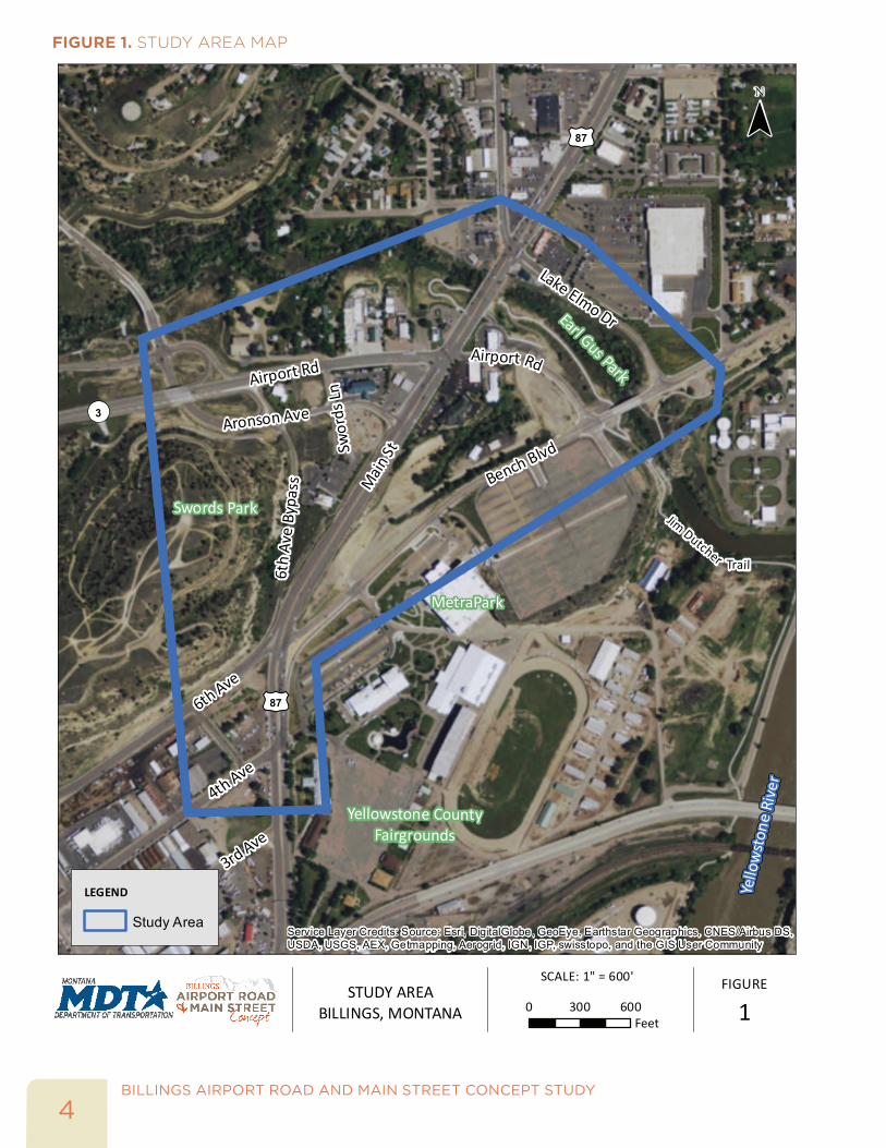
INTRODUCTIONSTUDY AREAThe Airport Road and Main Street intersection is located two miles northeast of downtown Billings, just north of MetraPark. The intersection’s location is a critical junction for commuter, regional, and freight trips along the Airport Road and Main Street corridors. Designated as Principal Arterials, the two corridors connect recreational, residential neighborhoods (Heights West and East), low density commercial, and light industrial uses with downtown Billings and Interstate 90. The intersection is located on the Camino Real International Trade Corridor that connects Canada, United States, and Mexico. Figure 1 highlights the study area with a major emphasis of this study being at the Airport Road and Main Street intersection.
The Airport Road and Main Street intersection is a four-legged, signalized intersection with a bypass connection via Aronson Avenue to the southwest of the intersection. In the southwest quadrant, the bypass connection (Aronson Avenue) functions as a partial unsignalized quadrant intersection, providing turning movements (northbound left turn, southbound right turn, and eastbound right turn) with a connection to local businesses and the Heights neighborhood via Aronson Avenue. Additionally, a grade-separated interchange is located approximately 1,500 feet to the west of the Airport Road/Main Street intersection. Aronson Avenue routes under Airport Road at the interchange and connects with Airport Road via two loop ramps.
STUDY PROCESS The Study effort was initiated in April 2015, and completed with consideration for Phase 2 development in July 2016. Exhibit 1 illustrates the study development process.
BILLINGS AIRPORT ROAD AND MAIN STREET CONCEPT STUDY
4
FIGURE 1. STUDY AREA MAP
Main
St
Bench Blvd
Airport Rd
Aronson Ave
6th Ave
4th Ave
Lake Elmo Dr
6th
Ave
Bypa
ss
RdAirport
Swords Park
MetraPark
Earl Gus Park
3rd AveYellowstone County
Fairgrounds
Jim Dutcher
Yello
wst
one
Rive
r
Trail
£¤87
£¤87
Swor
ds Ln
¬«3
Airport Rd & Main St - Billings CM 1099(102), UPN 8718000 July 2016
¯
FIGURE
1STUDY AREA
BILLINGS, MONTANA
H:\p
rojfi
le\1
8460
- A
irpor
t Roa
d &
Mai
n S
tree
t - B
illin
gs\g
is\b
ase\
final
rep
ort\S
tudy
Are
a8.5
x11.
mxd
- b
korp
oraa
l - 4
:34
PM
6/5
/201
6
Coordinate System: NAD 1983 StatePlane Montana FIPS 2500 Feet
LEGEND
Study Area
SCALE: 1" = 600'
0 600300Feet
Service Layer Credits: Source: Esri, DigitalGlobe, GeoEye, Earthstar Geographics, CNES/Airbus DS,USDA, USGS, AEX, Getmapping, Aerogrid, IGN, IGP, swisstopo, and the GIS User Community

5BILLINGS AIRPORT ROAD AND MAIN STREET CONCEPT STUDY
PAST STUDIES AND PLANSSeveral relevant past plans and studies were reviewed to understand the context of previous work completed in the study area, and to ensure that future intersection alternatives are consistent with any planned projects and the community’s vision for the respective corridors. The key findings relevant to the study area from the five studies are outlined in Table 1.
TABLE 1. SUMMARY OF PAST STUDIES AND PLANS
PAST STUDY/PLAN SUMMARY
East Billings Urban Renewal District (EBURD) Master Plan
• Completed in July 2009.• Defined some prototypical streetscape standards.• Guidance on lane width, street trees, and other modal facilities.
Traffic Report 6th Ave N/Bench-Blgs, Phase 2
• Completed in November 2012.• Evaluates several alternative intersection improvements at the 4th Avenue and 6th Avenue intersections with Bench Boulevard and Main Street.
• Provides near-term and long-term recommendations at the following intersections: Main St/6th Ave/Bench Blvd and Main St/1st Ave/US 87.
• Identifies that capacity improvements at Airport Rd/Main St would be needed in the future (projected to operate at LOS F in 2020 without the Bypass Arterial).
MetraPark Egress Improvements Study
• Completed in April 2013.• Identifies improvement recommendations to the overall circulation plan for MetraPark, specifically ingress/egress changes on Main St between 4th Ave and 6th Ave on Bench Blvd along the MetraPark frontage.
Hospitality Corridor Planning Study
• Completed in September 2013.• Provides a vision to integrate vehicular and non-vehicular needs within the Highway 87/Main Street/Exposition Drive corridor.
• Recommendations for street cross-sections, intersection improvements, and pedestrian enhancements in study area.
2014 Billings Urban Area Long Range Transportation Plan
• Completed in August 2014.• Identifies several transportation projects within study area including: roadway intersection and congestion management; upgrades and/or new pedestrian and bicycle infrastructure; and trail connections.
• Committed projects include: Main St/4th Ave N pavement preservation; Swords Park/6th Ave N trail connector; and the Alkali Creek Trail connection.
STUDY PURPOSE AND NEEDThe purpose of the Airport Road and Main Street Concept Study is to identify the need, type, location, and feasibility of a transportation project at the Airport Road and Main Street intersection in the City of Billings, Montana. Key elements of the study include:
• Identifying the existing and future deficiencies
• Identifying a list of intersection alternatives
• Evaluating and screening the intersection alternatives
• Identifying a preferred alternative for the intersection
This study serves as an analysis/pre-design study to aid in future decision-making at this intersection for MDT, City of Billings, and Yellowstone County. The study provides screening data regarding the feasibility of the alternatives under consideration, but is not an assessment to comply with the National Environmental Policy Act (NEPA) requirements. Any formal environmental documentation would be addressed in the next phase of the project development process.
BILLINGS AIRPORT ROAD AND MAIN STREET CONCEPT STUDY
6
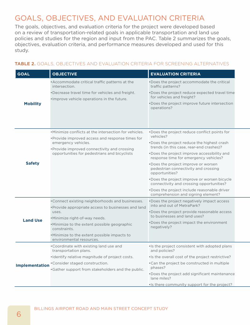
GOALS, OBJECTIVES, AND EVALUATION CRITERIAThe goals, objectives, and evaluation criteria for the project were developed based on a review of transportation-related goals in applicable transportation and land use policies and studies for the region and input from the PAC. Table 2 summarizes the goals, objectives, evaluation criteria, and performance measures developed and used for this study.
TABLE 2. GOALS, OBJECTIVES AND EVALUATION CRITERIA FOR SCREENING ALTERNATIVES
GOAL OBJECTIVE EVALUATION CRITERIA
Mobility
• Accommodate critical traffic patterns at the intersection.
• Decrease travel time for vehicles and freight.
• Improve vehicle operations in the future.
• Does the project accommodate the critical traffic patterns?
• Does the project reduce expected travel time for vehicles and freight?
• Does the project improve future intersection operations?
Safety
• Minimize conflicts at the intersection for vehicles.
• Provide improved access and response times for emergency vehicles.
• Provide improved connectivity and crossing opportunities for pedestrians and bicyclists
• Does the project reduce conflict points for vehicles?
• Does the project reduce the highest crash trends (in this case, rear-end crashes)?
• Does the project improve accessibility and response time for emergency vehicles?
• Does the project improve or worsen pedestrian connectivity and crossing opportunities?
• Does the project improve or worsen bicycle connectivity and crossing opportunities?
• Does the project include reasonable driver comprehension and signing element?
Land Use
• Connect existing neighborhoods and businesses.
• Provide appropriate access to businesses and land uses.
• Minimize right-of-way needs.
• Minimize to the extent possible geographic constraints.
• Minimize to the extent possible impacts to environmental resources.
• Does the project negatively impact access into and out of MetraPark?
• Does the project provide reasonable access to businesses and land uses?
• Does the project impact the environment negatively?
Implementation
• Coordinate with existing land use and transportation plans.
• Identify relative magnitude of project costs.
• Consider staged construction.
• Gather support from stakeholders and the public.
• Is the project consistent with adopted plans and policies?
• Is the overall cost of the project restrictive?
• Can the project be constructed in multiple phases?
• Does the project add significant maintenance lane miles?
• Is there community support for the project?
7BILLINGS AIRPORT ROAD AND MAIN STREET CONCEPT STUDY
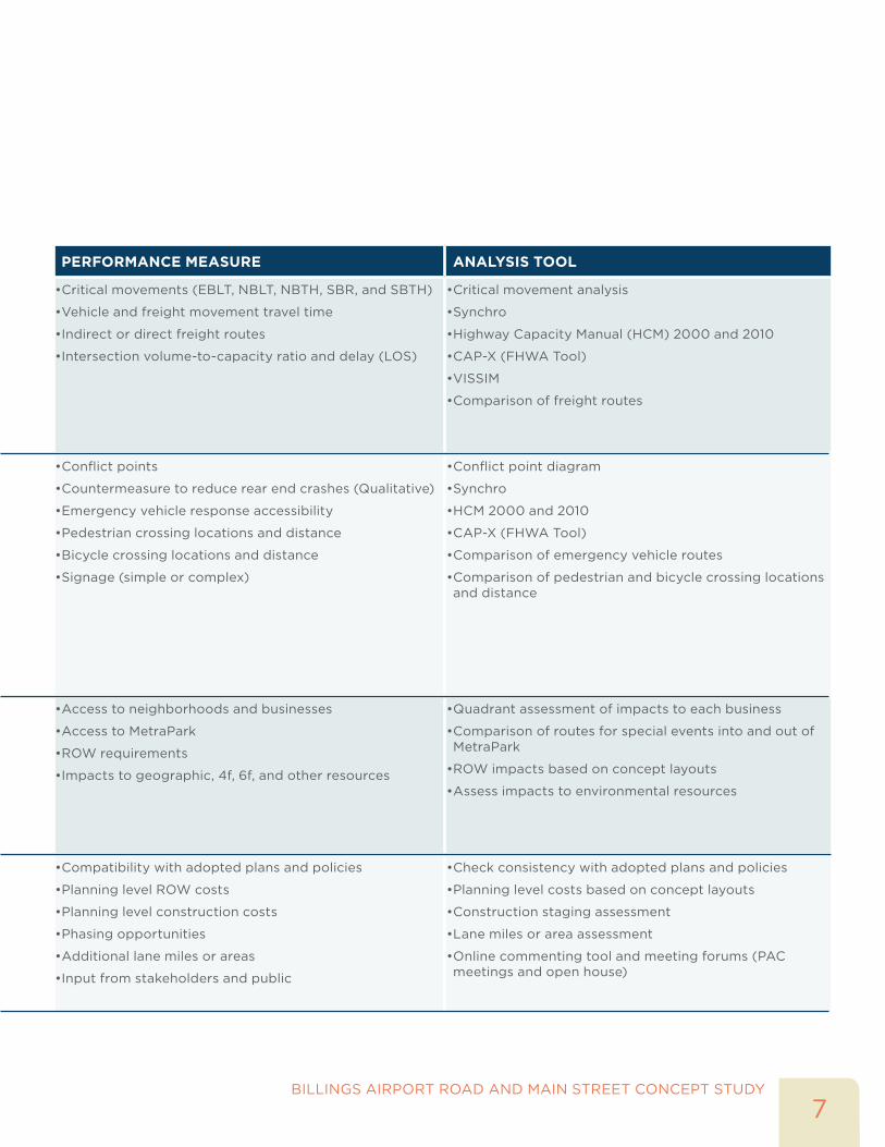
PERFORMANCE MEASURE ANALYSIS TOOL
• Critical movements (EBLT, NBLT, NBTH, SBR, and SBTH)
• Vehicle and freight movement travel time
• Indirect or direct freight routes
• Intersection volume-to-capacity ratio and delay (LOS)
• Critical movement analysis
• Synchro
• Highway Capacity Manual (HCM) 2000 and 2010
• CAP-X (FHWA Tool)
• VISSIM
• Comparison of freight routes
• Conflict points
• Countermeasure to reduce rear end crashes (Qualitative)
• Emergency vehicle response accessibility
• Pedestrian crossing locations and distance
• Bicycle crossing locations and distance
• Signage (simple or complex)
• Conflict point diagram
• Synchro
• HCM 2000 and 2010
• CAP-X (FHWA Tool)
• Comparison of emergency vehicle routes
• Comparison of pedestrian and bicycle crossing locations and distance
• Access to neighborhoods and businesses
• Access to MetraPark
• ROW requirements
• Impacts to geographic, 4f, 6f, and other resources
• Quadrant assessment of impacts to each business
• Comparison of routes for special events into and out of MetraPark
• ROW impacts based on concept layouts
• Assess impacts to environmental resources
• Compatibility with adopted plans and policies
• Planning level ROW costs
• Planning level construction costs
• Phasing opportunities
• Additional lane miles or areas
• Input from stakeholders and public
• Check consistency with adopted plans and policies
• Planning level costs based on concept layouts
• Construction staging assessment
• Lane miles or area assessment
• Online commenting tool and meeting forums (PAC meetings and open house)

BILLINGS AIRPORT ROAD AND MAIN STREET CONCEPT STUDY
8
This page intentionally left blank.
INTERAGENCY AND PUBLIC INVOLVEMENT PROGRAM

BILLINGS AIRPORT ROAD AND MAIN STREET CONCEPT STUDY
10
This page intentionally left blank.
11BILLINGS AIRPORT ROAD AND MAIN STREET CONCEPT STUDY
INTERAGENCY AND PUBLIC INVOLVEMENT PROGRAMOVERALL PLANThe goal of the public involvement plan was to facilitate communication between the public and project team throughout the project and gather insights and direction for implementation.
PROJECT ADVISORY COMMITTEEThe Project Advisory Committee (PAC) advised the project team on the technical elements of the project, and made the final decision regarding the overall project direction, based on input from the project team and the public. The PAC participated in four meetings occurring on August 27, 2015, October 22, 2015, February 4, 2016, and February 25, 2016, in addition to the public informational meeting (PIM) held on May 18, 2016 in Billings, MT.
PAC meetings were held at various times throughout the project to update the PAC on project findings to date. Meetings included presentations on the findings of existing and future conditions within the study area, an environmental scan overview, the study’s purpose and need, initial alternatives, verifying evaluation criteria to determine refined alternatives and presenting recommended alternatives based on the evaluation criteria. PAC meetings also included discussion on public outreach development, project website’s content, preparation of letters sent to business and property owners, news releases, and the PIM. All PAC meeting summaries are included in the technical appendix.
PUBLIC OUTREACH
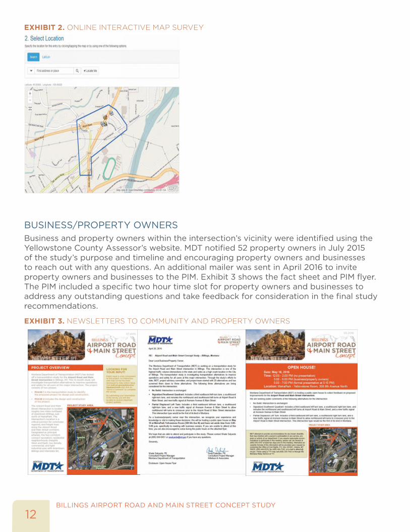
PROJECT WEBSITEA project website was developed and hosted by MDT throughout the duration of the project. The site is located on MDT’s project page with an address of:http://www.mdt.mt.gov/pubinvolve/blgairportmain/pub-involve.shtml The website provided the public with an overview and schedule of the project and technical memoranda from the study. The website encouraged the public to place comments using an interactive map survey of the study area. Exhibit 2 illustrates the interactive map survey.
BILLINGS AIRPORT ROAD AND MAIN STREET CONCEPT STUDY
12
EXHIBIT 2. ONLINE INTERACTIVE MAP SURVEY
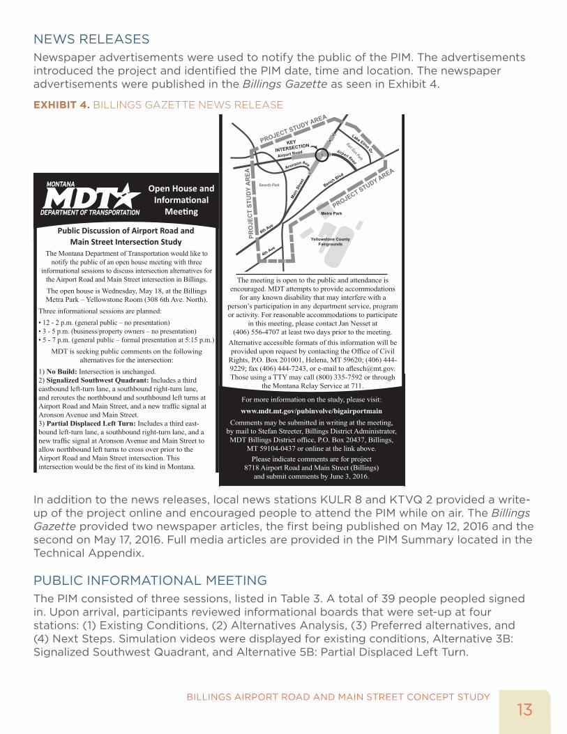
BUSINESS/PROPERTY OWNERSBusiness and property owners within the intersection’s vicinity were identified using the Yellowstone County Assessor’s website. MDT notified 52 property owners in July 2015 of the study’s purpose and timeline and encouraging property owners and businesses to reach out with any questions. An additional mailer was sent in April 2016 to invite property owners and businesses to the PIM. Exhibit 3 shows the fact sheet and PIM flyer. The PIM included a specific two hour time slot for property owners and businesses to address any outstanding questions and take feedback for consideration in the final study recommendations.
EXHIBIT 3. NEWSLETTERS TO COMMUNITY AND PROPERTY OWNERS
13BILLINGS AIRPORT ROAD AND MAIN STREET CONCEPT STUDY
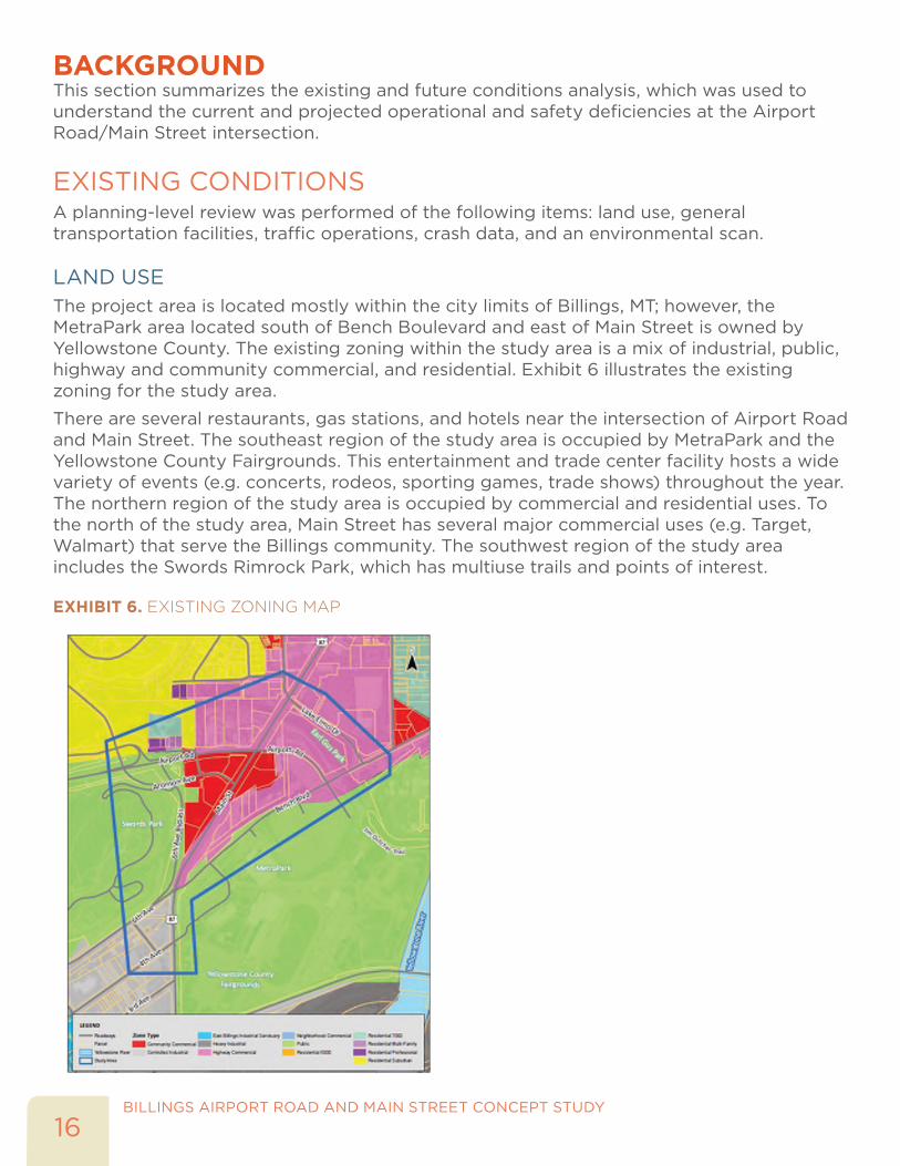
NEWS RELEASESNewspaper advertisements were used to notify the public of the PIM. The advertisements introduced the project and identified the PIM date, time and location. The newspaper advertisements were published in the Billings Gazette as seen in Exhibit 4.
EXHIBIT 4. BILLINGS GAZETTE NEWS RELEASE
Open House andInformational
Meeting
The Montana Department of Transportation would like tonotify the public of an open house meeting with three
informational sessions to discuss intersection alternatives forthe Airport Road and Main Street intersection in Billings.The open house is Wednesday, May 18, at the BillingsMetra Park –Yellowstone Room (308 6th Ave. North).
Three informational sessions are planned:• 12 - 2 p.m. (general public – no presentation)• 3 - 5 p.m. (business/property owners – no presentation)• 5 - 7 p.m. (general public – formal presentation at 5:15 p.m.)
MDT is seeking public comments on the followingalternatives for the intersection:
1) No Build: Intersection is unchanged.2) Signalized Southwest Quadrant: Includes a thirdeastbound left-turn lane, a southbound right-turn lane,and reroutes the northbound and southbound left turns atAirport Road and Main Street, and a new traffic signal atAronsonAvenue and Main Street.3) Partial Displaced Left Turn: Includes a third east-bound left-turn lane, a southbound right-turn lane, and anew traffic signal at AronsonAvenue and Main Street toallow northbound left turns to cross over prior to theAirport Road and Main Street intersection. Thisintersection would be the first of its kind in Montana.
Public Discussion of Airport Road andMain Street Intersection Study
The meeting is open to the public and attendance isencouraged. MDT attempts to provide accommodationsfor any known disability that may interfere with a
person’s participation in any department service, programor activity. For reasonable accommodations to participate
in this meeting, please contact Jan Nesset at(406) 556-4707 at least two days prior to the meeting.Alternative accessible formats of this information will beprovided upon request by contacting the Office of CivilRights, P.O. Box 201001, Helena, MT 59620; (406) 444-9229; fax (406) 444-7243, or e-mail to [email protected].
PROJECT
STUDY A
REA
Yellowstone CountyFairgrounds
Metra Park
Swords Park
Earl Gus Park
KEY
INTERSECTION
Airport Road
AronsonAve
BenchBlvd
Lake Elmo DrAirport Road
6thAve
4thAve
MainStreet
PROJECTSTUDYAREA
PROJE
CTSTU
DYAREA
alternatives for the intersection:1) No Build: Intersection is unchanged.2) Signalized Southwest Quadrant: Includes a thirdeastbound left-turn lane, a southbound right-turn lane,and reroutes the northbound and southbound left turns atAirport Road and Main Street, and a new traffic signal atAronsonAvenue and Main Street.3) Partial Displaced Left Turn: Includes a third east-bound left-turn lane, a southbound right-turn lane, and anew traffic signal at AronsonAvenue and Main Street toallow northbound left turns to cross over prior to theAirport Road and Main Street intersection. Thisintersection would be the first of its kind in Montana.
The meeting is open to the public and attendance isencouraged. MDT attempts to provide accommodationsfor any known disability that may interfere with a
person’s participation in any department service, programor activity. For reasonable accommodations to participate
in this meeting, please contact Jan Nesset at(406) 556-4707 at least two days prior to the meeting.Alternative accessible formats of this information will beprovided upon request by contacting the Office of CivilRights, P.O. Box 201001, Helena, MT 59620; (406) 444-9229; fax (406) 444-7243, or e-mail to [email protected] using a TTYmay call (800) 335-7592 or through
the Montana Relay Service at 711.
PROJECT
STUDY A
REA
Yellowstone CountyFairgrounds
Metra Park
Swords Park
Earl Gus Park
KEY
INTERSECTION
Airport Road
AronsonAve
BenchBlvd
Lake Elmo DrAirport Road
6thAve
4thAve
MainStreet
PROJECTSTUDYAREA
PROJE
CTSTU
DYAREA
For more information on the study, please visit:www.mdt.mt.gov/pubinvolve/bigairportmain
Comments may be submitted in writing at the meeting,by mail to Stefan Streeter, Billings District Administrator,MDT Billings District office, P.O. Box 20437, Billings,
MT 59104-0437 or online at the link above.Please indicate comments are for project
8718Airport Road and Main Street (Billings)and submit comments by June 3, 2016.
In addition to the news releases, local news stations KULR 8 and KTVQ 2 provided a write-up of the project online and encouraged people to attend the PIM while on air. The Billings Gazette provided two newspaper articles, the first being published on May 12, 2016 and the second on May 17, 2016. Full media articles are provided in the PIM Summary located in the Technical Appendix.
PUBLIC INFORMATIONAL MEETINGThe PIM consisted of three sessions, listed in Table 3. A total of 39 people peopled signed in. Upon arrival, participants reviewed informational boards that were set-up at four stations: (1) Existing Conditions, (2) Alternatives Analysis, (3) Preferred alternatives, and (4) Next Steps. Simulation videos were displayed for existing conditions, Alternative 3B: Signalized Southwest Quadrant, and Alternative 5B: Partial Displaced Left Turn.

BILLINGS AIRPORT ROAD AND MAIN STREET CONCEPT STUDY
14
Attendees had the opportunity to review the display boards, simulation videos, and ask questions of staff from both the MDT and consultant team. The consultant team gave a 30-minute presentation about the study and addressed several questions from the audience.
TABLE 3. PIM OPEN HOUSE SCHEDULE
TIME PERIOD AGENDA12:00 to 2:00 PM (Public) • Sign In
• View project boards
• Fill out comment sheet
3:00 to 5:00 PM (Business Owners) • Sign In
• View project boards
• Fill out comment sheet
5:00 to 7:00 PM (Public) • Sign In
• Presentation at 5:15 PM
• Q&A from the attendees
• View project boards
• Fill out comment sheet
Comment sheets were collected at the PIM and open comments were received via email or website until June 17, 2016, a month following the PIM. A total of eight comment sheets were collected at the PIM and four were received following the PIM for a total of 12 comment sheets received. The comment sheets asked attendees to select whether they supported the implementation of each of the three recommended alternatives, why or why not, and provide general comments of the study and/or alternatives. Exhibit 5 shows some of the display boards and room layout from the PIM.
EXHIBIT 5. PUBLIC INFORMATIONAL MEETING

BACKGROUND
BILLINGS AIRPORT ROAD AND MAIN STREET CONCEPT STUDY
16
BACKGROUND This section summarizes the existing and future conditions analysis, which was used to understand the current and projected operational and safety deficiencies at the Airport Road/Main Street intersection.
EXISTING CONDITIONSA planning-level review was performed of the following items: land use, general transportation facilities, traffic operations, crash data, and an environmental scan.
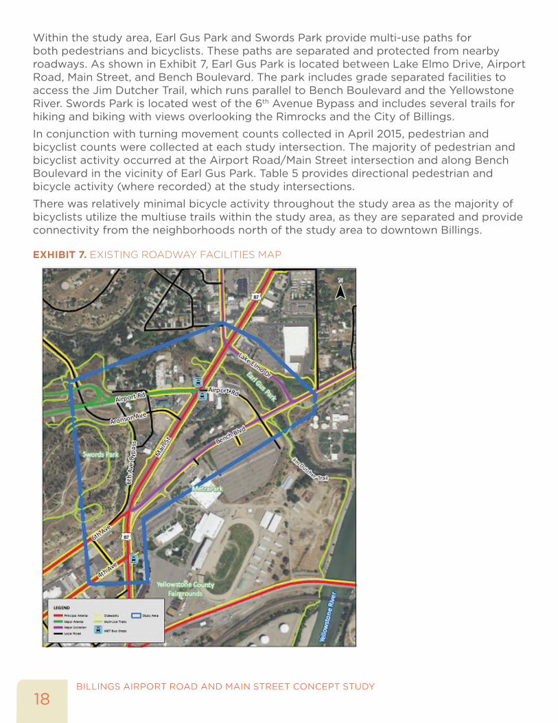
LAND USEThe project area is located mostly within the city limits of Billings, MT; however, the MetraPark area located south of Bench Boulevard and east of Main Street is owned by Yellowstone County. The existing zoning within the study area is a mix of industrial, public, highway and community commercial, and residential. Exhibit 6 illustrates the existing zoning for the study area.
There are several restaurants, gas stations, and hotels near the intersection of Airport Road and Main Street. The southeast region of the study area is occupied by MetraPark and the Yellowstone County Fairgrounds. This entertainment and trade center facility hosts a wide variety of events (e.g. concerts, rodeos, sporting games, trade shows) throughout the year. The northern region of the study area is occupied by commercial and residential uses. To the north of the study area, Main Street has several major commercial uses (e.g. Target, Walmart) that serve the Billings community. The southwest region of the study area includes the Swords Rimrock Park, which has multiuse trails and points of interest.
EXHIBIT 6. EXISTING ZONING MAP

17BILLINGS AIRPORT ROAD AND MAIN STREET CONCEPT STUDY
TRANSPORTATION FACILITIESA review of the existing transportation facilities was conducted, in conjunction with field visits in April 2015, February 2016, and May 2016. Roadways within the study area were identified and catalogued in Table 4 and are highlighted in Exhibit 7.
TABLE 4. EXISTING ROADWAY CHARACTERISTICS
ROADWAYFUNCTIONAL
CLASSIFICATION1
# OF TRAVEL LANES
POSTED SPEED (MPH)
PEDESTRIAN FACILITIES
BICYCLE FACILITIES2
AVERAGE DAILY
TRAFFIC (ADT)3
AM PEAK/ PM PEAK4
4th Avenue North Principal Arterial 3 35 Yes No 14,000 535/
1,675
6th Avenue Bypass Local 1 35 Partial Primary Bike
Route 4,800 760/ 200
6th Avenue North Principal Arterial 4 35 Yes Arterial Bike
Route 13,800 2,170/ 935
Alkali Creek Road Major Arterial 2 25 Partial Primary Bike
Route 3,400 380/ 220
Airport Road Major Arterial 4 - 6 45 - 50 Partial Arterial Bike Route
11,800 - 13,000
1,015/ 1,610
Aronson Avenue Local 2 25 Partial No 3,100 310/
645
Bench Boulevard Major Collector 2 35 Partial Partial 6,500 960/
1,110
Main Street Principal Arterial 6 35 Yes No 38,000 - 49,300
3,060/ 4,090
Lake Elmo Drive Major Collector 2 25 Partial Primary Bike
Route 6,600 700/ 865
Swords Lane Local 2 25 Partial No 800 45/ 75
Notes: 1 Roadway functional classification was derived from MDT Road Inventory and Mapping Section, created in January 2015; 2 There are no bike lanes on any roadways within the study area, bike routes were highlighted by the City of Billings Parks and Recreation; 3 ADT counts are from the 2014 Billings Urbanized Area Traffic Count Map provided by the City of Billing or estimated based on the peak hour counts; and 4 AM and PM peak hour counts are from turning movement counts collected at each study intersection in April 2015 and are shown in Figures 3 and 4.
PEDESTRIAN AND BICYCLIST ACTIVITY
Exhibit 7 highlights the location of sidewalks along study roadways. Main Street, 4th Avenue North, and 6th Avenue North are the only roadways with sidewalks on both sides of the road. An asphalt path is provided along the 6th Avenue Bypass and Swords Lane. The remaining roadways maintain partial and/or intermittent sidewalks.
No bike lanes are provided on any of the roadways within the study area. However, the City of Billings has designated several roadways within the study area as “Arterial Bike Routes” or “Primary Bike Routes,” identified in Table 4.
BILLINGS AIRPORT ROAD AND MAIN STREET CONCEPT STUDY
18
Within the study area, Earl Gus Park and Swords Park provide multi-use paths for both pedestrians and bicyclists. These paths are separated and protected from nearby roadways. As shown in Exhibit 7, Earl Gus Park is located between Lake Elmo Drive, Airport Road, Main Street, and Bench Boulevard. The park includes grade separated facilities to access the Jim Dutcher Trail, which runs parallel to Bench Boulevard and the Yellowstone River. Swords Park is located west of the 6th Avenue Bypass and includes several trails for hiking and biking with views overlooking the Rimrocks and the City of Billings.
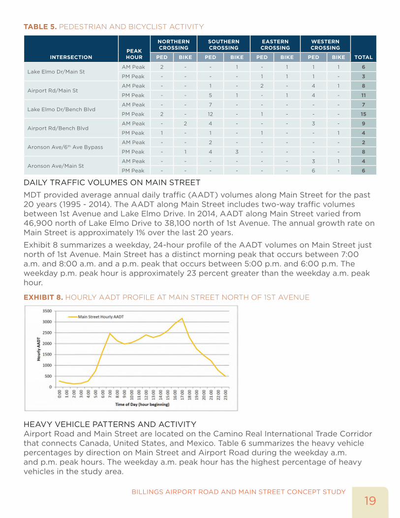
In conjunction with turning movement counts collected in April 2015, pedestrian and bicyclist counts were collected at each study intersection. The majority of pedestrian and bicyclist activity occurred at the Airport Road/Main Street intersection and along Bench Boulevard in the vicinity of Earl Gus Park. Table 5 provides directional pedestrian and bicycle activity (where recorded) at the study intersections.
There was relatively minimal bicycle activity throughout the study area as the majority of bicyclists utilize the multiuse trails within the study area, as they are separated and provide connectivity from the neighborhoods north of the study area to downtown Billings.
EXHIBIT 7. EXISTING ROADWAY FACILITIES MAP
19BILLINGS AIRPORT ROAD AND MAIN STREET CONCEPT STUDY
TABLE 5. PEDESTRIAN AND BICYCLIST ACTIVITY
INTERSECTIONPEAK HOUR
NORTHERN CROSSING
SOUTHERN CROSSING
EASTERN CROSSING
WESTERN CROSSING
TOTALPED BIKE PED BIKE PED BIKE PED BIKE
Lake Elmo Dr/Main StAM Peak 2 - - 1 - 1 1 1 6
PM Peak - - - - 1 1 1 - 3
Airport Rd/Main StAM Peak - - 1 - 2 - 4 1 8
PM Peak - - 5 1 - 1 4 - 11
Lake Elmo Dr/Bench BlvdAM Peak - - 7 - - - - - 7
PM Peak 2 - 12 - 1 - - - 15
Airport Rd/Bench BlvdAM Peak - 2 4 - - - 3 - 9
PM Peak 1 - 1 - 1 - - 1 4
Aronson Ave/6th Ave BypassAM Peak - - 2 - - - - - 2
PM Peak - 1 4 3 - - - - 8
Aronson Ave/Main StAM Peak - - - - - - 3 1 4
PM Peak - - - - - - 6 - 6
DAILY TRAFFIC VOLUMES ON MAIN STREET
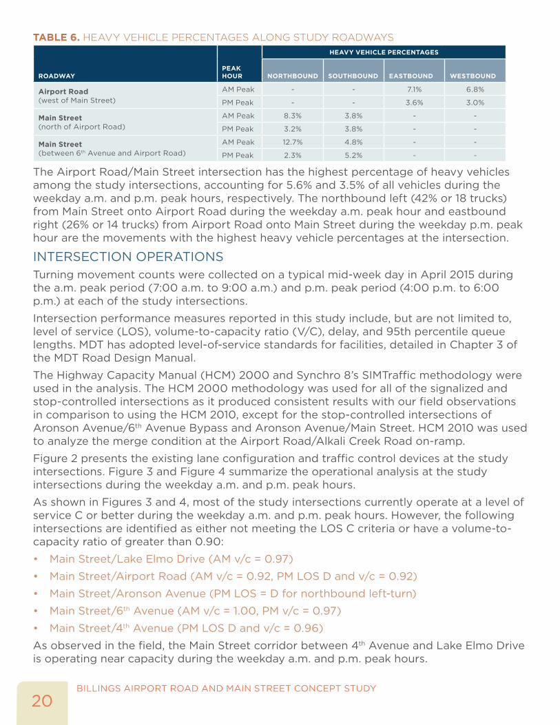
MDT provided average annual daily traffic (AADT) volumes along Main Street for the past 20 years (1995 - 2014). The AADT along Main Street includes two-way traffic volumes between 1st Avenue and Lake Elmo Drive. In 2014, AADT along Main Street varied from 46,900 north of Lake Elmo Drive to 38,100 north of 1st Avenue. The annual growth rate on Main Street is approximately 1% over the last 20 years.
Exhibit 8 summarizes a weekday, 24-hour profile of the AADT volumes on Main Street just north of 1st Avenue. Main Street has a distinct morning peak that occurs between 7:00 a.m. and 8:00 a.m. and a p.m. peak that occurs between 5:00 p.m. and 6:00 p.m. The weekday p.m. peak hour is approximately 23 percent greater than the weekday a.m. peak hour.
EXHIBIT 8. HOURLY AADT PROFILE AT MAIN STREET NORTH OF 1ST AVENUE
HEAVY VEHICLE PATTERNS AND ACTIVITYAirport Road and Main Street are located on the Camino Real International Trade Corridor that connects Canada, United States, and Mexico. Table 6 summarizes the heavy vehicle percentages by direction on Main Street and Airport Road during the weekday a.m. and p.m. peak hours. The weekday a.m. peak hour has the highest percentage of heavy vehicles in the study area.
BILLINGS AIRPORT ROAD AND MAIN STREET CONCEPT STUDY
20
TABLE 6. HEAVY VEHICLE PERCENTAGES ALONG STUDY ROADWAYS
ROADWAYPEAK HOUR
HEAVY VEHICLE PERCENTAGES
NORTHBOUND SOUTHBOUND EASTBOUND WESTBOUND
Airport Road (west of Main Street)
AM Peak - - 7.1% 6.8%
PM Peak - - 3.6% 3.0%
Main Street (north of Airport Road)
AM Peak 8.3% 3.8% - -
PM Peak 3.2% 3.8% - -
Main Street (between 6th Avenue and Airport Road)
AM Peak 12.7% 4.8% - -
PM Peak 2.3% 5.2% - -
The Airport Road/Main Street intersection has the highest percentage of heavy vehicles among the study intersections, accounting for 5.6% and 3.5% of all vehicles during the weekday a.m. and p.m. peak hours, respectively. The northbound left (42% or 18 trucks) from Main Street onto Airport Road during the weekday a.m. peak hour and eastbound right (26% or 14 trucks) from Airport Road onto Main Street during the weekday p.m. peak hour are the movements with the highest heavy vehicle percentages at the intersection.
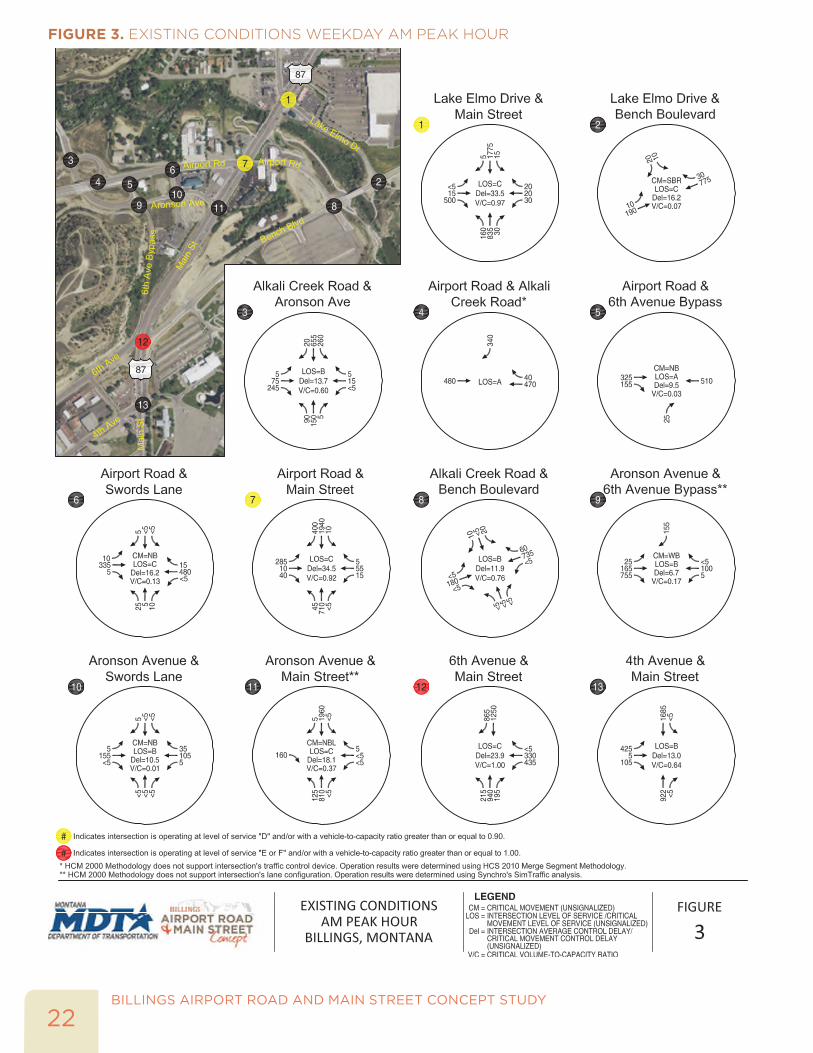
INTERSECTION OPERATIONSTurning movement counts were collected on a typical mid-week day in April 2015 during the a.m. peak period (7:00 a.m. to 9:00 a.m.) and p.m. peak period (4:00 p.m. to 6:00 p.m.) at each of the study intersections.
Intersection performance measures reported in this study include, but are not limited to, level of service (LOS), volume-to-capacity ratio (V/C), delay, and 95th percentile queue lengths. MDT has adopted level-of-service standards for facilities, detailed in Chapter 3 of the MDT Road Design Manual.
The Highway Capacity Manual (HCM) 2000 and Synchro 8’s SIMTraffic methodology were used in the analysis. The HCM 2000 methodology was used for all of the signalized and stop-controlled intersections as it produced consistent results with our field observations in comparison to using the HCM 2010, except for the stop-controlled intersections of Aronson Avenue/6th Avenue Bypass and Aronson Avenue/Main Street. HCM 2010 was used to analyze the merge condition at the Airport Road/Alkali Creek Road on-ramp.
Figure 2 presents the existing lane configuration and traffic control devices at the study intersections. Figure 3 and Figure 4 summarize the operational analysis at the study intersections during the weekday a.m. and p.m. peak hours.
As shown in Figures 3 and 4, most of the study intersections currently operate at a level of service C or better during the weekday a.m. and p.m. peak hours. However, the following intersections are identified as either not meeting the LOS C criteria or have a volume-to-capacity ratio of greater than 0.90:
• Main Street/Lake Elmo Drive (AM v/c = 0.97)
• Main Street/Airport Road (AM v/c = 0.92, PM LOS D and v/c = 0.92)
• Main Street/Aronson Avenue (PM LOS = D for northbound left-turn)
• Main Street/6th Avenue (AM v/c = 1.00, PM v/c = 0.97)
• Main Street/4th Avenue (PM LOS D and v/c = 0.96)
As observed in the field, the Main Street corridor between 4th Avenue and Lake Elmo Drive is operating near capacity during the weekday a.m. and p.m. peak hours.
21BILLINGS AIRPORT ROAD AND MAIN STREET CONCEPT STUDY
FIGURE 2. EXISTING LANE CONFIGURATIONS AND TRAFFIC CONTROL DEVICES
BILLINGS AIRPORT ROAD AND MAIN STREET CONCEPT STUDY
22
FIGURE 3. EXISTING CONDITIONS WEEKDAY AM PEAK HOUR

23BILLINGS AIRPORT ROAD AND MAIN STREET CONCEPT STUDY
FIGURE 4. EXISTING CONDITIONS WEEKDAY PM PEAK HOUR
BILLINGS AIRPORT ROAD AND MAIN STREET CONCEPT STUDY
24
The operations analysis also included an evaluation of 95th percentile queue lengths at each of the study intersections. Field observations confirm the 95th percentile queue results. The following are key results from the analysis and observations from the field visit:
• Lake Elmo Drive/Main Street – The queue length for the eastbound right exceeds the storage length during the weekday a.m. and p.m. peak hours. There is currently an exclusive right-turn lane with a storage length of 100 feet, which is inadequate to accommodate the right-turn traffic volume.
• Airport Road/Main Street - The eastbound left turn experiences high delay and at times long vehicle queues during the weekday p.m. peak hour. During the weekday a.m. peak hour, vehicle queues in the southbound through direction were observed to spill back to the Lake Elmo Drive intersection. There is currently no southbound right-turn lane, so vehicles making the right-turn on to Airport Road must wait until the southbound through movement gets a green indication. The northbound vehicle queues were observed to spillback to or past the Aronson Drive/Main Street intersection during the weekday p.m. peak hour.
• Aronson Avenue/Main Street – The unsignalized intersection of Aronson Avenue/Main Street experiences a high volume of northbound left turns (495 in the p.m. peak hour). This movement was observed to fill the storage length turn lane and on occasion, spill back into the through lanes on Main Street.
• 6th Avenue/Main Street/Bench Boulevard - The northbound left turn is at capacity during the weekday a.m. peak hour, which results in queues exceeding the storage lane. During the weekday p.m. peak hour, the queue length of the northbound through movement was observed to spillback past the 4th Avenue/Main Street intersection, resulting in a lack of progression for vehicles trying to make a left turn from 4th Avenue onto Main Street.
• 4th Avenue/Main Street - The eastbound left turn experiences long delays and queues during the weekday p.m. peak hour. For the majority of the weekday p.m. peak hour when the eastbound left turn’s phase turns green, vehicles must wait for the northbound through queue on Main Street to clear before entering the intersection. In addition, the southbound through queue length reaches storage capacity during the weekday a.m. peak hour. Spillback from this intersection into the 6th Avenue intersection was not observed; however, at times southbound through queues at 4th Avenue did inhibit westbound left turns from Bench Boulevard from being able to turn onto Main Street and head south.
25BILLINGS AIRPORT ROAD AND MAIN STREET CONCEPT STUDY
EVENT TRAFFIC CONDITIONSTurning movement counts were collected at each of the study intersections on Friday, April 17, 2015 from 4:00 p.m. to 12:00 a.m. during a Professional Bull Riding Rodeo at MetraPark. The Rimrock Auto Area at MetraPark has a capacity of 12,000 seats and was host to the Professional Bull Riding Rodeo from 8:00 p.m. to 10:00 p.m. on that evening.
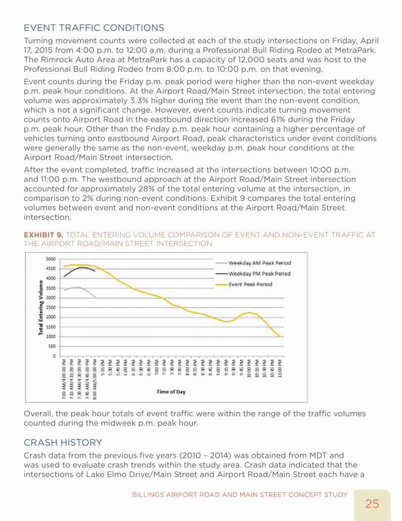
Event counts during the Friday p.m. peak period were higher than the non-event weekday p.m. peak hour conditions. At the Airport Road/Main Street intersection, the total entering volume was approximately 3.3% higher during the event than the non-event condition, which is not a significant change. However, event counts indicate turning movement counts onto Airport Road in the eastbound direction increased 61% during the Friday p.m. peak hour. Other than the Friday p.m. peak hour containing a higher percentage of vehicles turning onto eastbound Airport Road, peak characteristics under event conditions were generally the same as the non-event, weekday p.m. peak hour conditions at the Airport Road/Main Street intersection.
After the event completed, traffic increased at the intersections between 10:00 p.m. and 11:00 p.m. The westbound approach at the Airport Road/Main Street intersection accounted for approximately 28% of the total entering volume at the intersection, in comparison to 2% during non-event conditions. Exhibit 9 compares the total entering volumes between event and non-event conditions at the Airport Road/Main Street intersection.
EXHIBIT 9. TOTAL ENTERING VOLUME COMPARISON OF EVENT AND NON-EVENT TRAFFIC AT THE AIRPORT ROAD/MAIN STREET INTERSECTION
Overall, the peak hour totals of event traffic were within the range of the traffic volumes counted during the midweek p.m. peak hour.
CRASH HISTORYCrash data from the previous five years (2010 – 2014) was obtained from MDT and was used to evaluate crash trends within the study area. Crash data indicated that the intersections of Lake Elmo Drive/Main Street and Airport Road/Main Street each have a

BILLINGS AIRPORT ROAD AND MAIN STREET CONCEPT STUDY
26
crash rate higher than one crash per million vehicles entering the intersection. Similar to corridor wide crash trends, rear-end crashes accounted for nearly two-thirds of the crashes at the two signalized intersections. Exhibit 10 summarizes the crash data at the Lake Elmo Drive/Main Street intersection. There were 147 reported crashes at the Lake Elmo Drive/Main Street intersection, highest amongst all study intersections. This intersection had the highest percentage of rear-end crashes of the study intersections. No fatality crashes were reported at the intersection.
EXHIBIT 10. CRASH DATA AT LAKE ELMO DRIVE/MAIN STREET INTERSECTION
ZERO14735%
1.78reported crashes
from 2010-2014
reported fatalities at the intersection in the past 5 yearscrashes were
injury related
crashes per million vehicles entering
69% of crashes were rear-end crashes
Exhibit 11 summarizes the crash data at the Airport Road/Main Street intersection. There were 111 reported crashes at the intersection, of which 68 were rear-end crashes. No fatality crashes were reported at the intersection.
EXHIBIT 11. CRASH DATA AT AIRPORT ROAD/MAIN STREET INTERSECTION
ZERO11140%
1.33reported crashes
from 2010-2014
reported fatalities at the intersection in the past 5 yearscrashes were
injury related
crashes per million vehicles entering
61% of crashes were rear-end crashes
ENVIRONMENTAL SCANAn environmental scan was completed to identify potential environmental constraints within the study area to inform the development and evaluation of alternatives during the concept phase, and for future insights as this project moves into final design. Based on the environmental scan, the study area includes the following key environmental items:
• 4(f) Resources
• three recreational properties: Swords Park, Earl Guss Park, and MetraPark
• three historical properties: Black Otter Trail, Boothill Cemetery, and Larry’s Overlook
• two inactive and three active hazardous materials sites;
• three listed endangered species, one protected as a Special Status Species, and one listed State Species of Concern; and
• a classified surface water with Alkali Creek (e.g. all state surface water and ground water are classified to the beneficial uses supported by each water body/segment).
This environmental scan is not meant to be used as or substituted for a comprehensive environmental investigation. If improvement options are forwarded from this study into project development, an analysis for compliance with the National and Montana Environmental Policy Acts (NEPA and MEPA) will be completed as part of the MDT project

27BILLINGS AIRPORT ROAD AND MAIN STREET CONCEPT STUDY
development process. Information provided in this study may be forwarded into the NEPA/MEPA process at that time.
FUTURE YEAR 2040 CONDITIONSFuture conditions reflect traffic conditions in year 2040, which documents programmed facility improvements, growth within the region, and the anticipated operational performance within the study area.
TRAFFIC PROJECTIONSThe MDT regional travel demand model for the Billings Urban Area/Yellowstone County was used to develop year 2040 traffic volume forecasts on the roadway links and intersections within the study area. The model includes the Billings Bypass Arterial and Inner Belt Loop projects. NCHRP Report 765 – Analytical Travel Forecasting Approaches for Project-Level Planning and Design was used to post-process the model output and estimate year 2040 traffic volume forecasts. An operational analysis was performed at the study intersections during the year 2040 traffic conditions, weekday a.m. and p.m. peak hours. Table 7 summarizes the link volumes and annual growth between the year 2015 and 2040 daily traffic volumes in the study area.
TABLE 7. YEAR 2015 AND YEAR 2040 DAILY TRAFFIC VOLUMES AND ANNUAL GROWTH
ROADWAY SEGMENT LOCATION ON ROADWAY YEAR 2015 DAILY VOLUME
YEAR 2040 DAILY VOLUME
ANNUAL GROWTH
Main Street North of Lake Elmo Drive 43,000 56,200 1.1%
Main Street North of Airport Road 52,200 66,800 1.0%
Main Street South of Airport Road 49,300 70,600 1.4%
Main Street South of 6th Avenue 56,000 81,300 1.5%
Main Street South of 4th Avenue 39,800 63,000 1.9%
Airport Road West of Main Street 14,100 21,900 1.8%
Airport Road West of Aronson Avenue 19,800 35,200 2.3%
Airport Road East of Main Street 2,000 6,100 4.5%
Bench Boulevard South of Airport Road 13,400 21,300 1.9%
Bench Boulevard North of Airport Road 14,800 26,300 2.3%
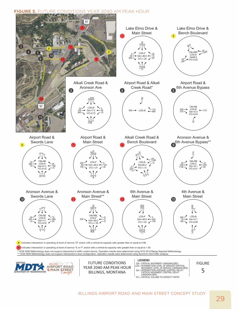
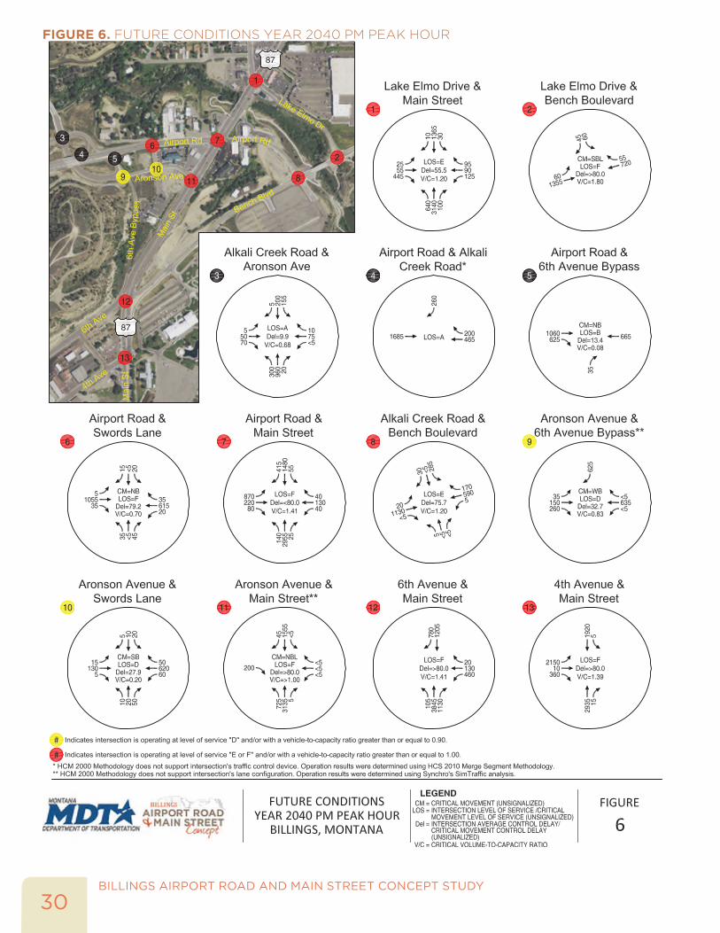
As shown in Table 7, the average annual growth is approximately 1.4% percent on Main Street and 2.1% percent on Airport Road. Main Street is projected to carry approximately 56,000 to 81,000 daily traffic volumes with the Billings Bypass Arterial in place. Airport Road is projected to carry approximately 22,000 to 35,000 daily traffic volumes with the Billings Bypass Arterial in place. Figure 5 and Figure 6 illustrate the year 2040 traffic volumes during the weekday a.m. and p.m. peak hours, respectively.
INTERSECTION OPERATIONSAn operational analysis was performed at the study intersections using the same methodology and assumptions under existing conditions with the exception of using a peak hour factor of 1.0 for this planning level analysis at the study intersections. Given the planning horizon year of 2040 and uncertainty with the forecast traffic volumes, all year 2040 analyses assumed a peak hour factor (PHF) of 1.0 to represent an hourly analysis, which is reasonable for long-range planning.
BILLINGS AIRPORT ROAD AND MAIN STREET CONCEPT STUDY
28
The year 2040 operational analysis results are shown in Figure 5 and Figure 6. As shown in the operational analysis, all of the signalized intersections and most of the unsignalized intersections are projected to operate at LOS E or worse with a volume-to-capacity ratio of greater than 1.0 under year 2040 weekday a.m. and p.m. peak hour traffic conditions. The operational analysis is consistent with the findings from the Billings Urban Area LRTP and Traffic Report from the 6th Ave N/Bench-Blgs, Phase 2 study.
29BILLINGS AIRPORT ROAD AND MAIN STREET CONCEPT STUDY
FIGURE 5. FUTURE CONDITIONS YEAR 2040 AM PEAK HOUR
BILLINGS AIRPORT ROAD AND MAIN STREET CONCEPT STUDY
30
FIGURE 6. FUTURE CONDITIONS YEAR 2040 PM PEAK HOUR

ALTERNATIVES DEVELOPMENT AND EVALUATION

BILLINGS AIRPORT ROAD AND MAIN STREET CONCEPT STUDY
32
This page intentionally left blank.
33BILLINGS AIRPORT ROAD AND MAIN STREET CONCEPT STUDY
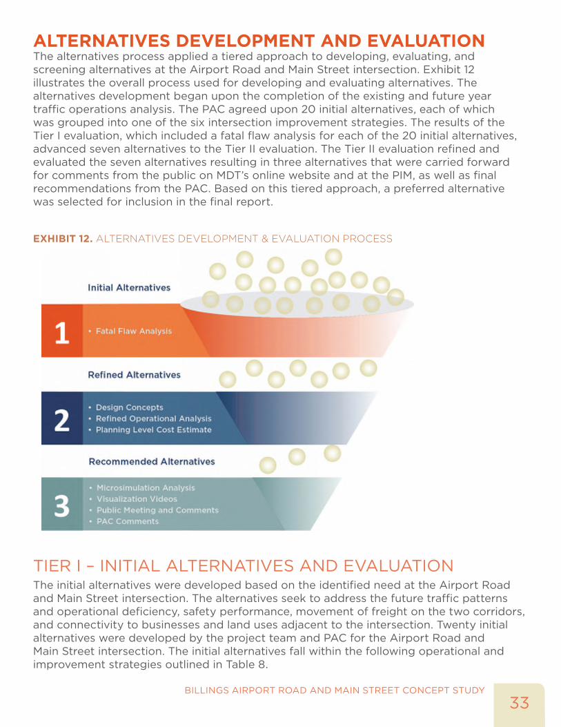
ALTERNATIVES DEVELOPMENT AND EVALUATIONThe alternatives process applied a tiered approach to developing, evaluating, and screening alternatives at the Airport Road and Main Street intersection. Exhibit 12 illustrates the overall process used for developing and evaluating alternatives. The alternatives development began upon the completion of the existing and future year traffic operations analysis. The PAC agreed upon 20 initial alternatives, each of which was grouped into one of the six intersection improvement strategies. The results of the Tier I evaluation, which included a fatal flaw analysis for each of the 20 initial alternatives, advanced seven alternatives to the Tier II evaluation. The Tier II evaluation refined and evaluated the seven alternatives resulting in three alternatives that were carried forward for comments from the public on MDT’s online website and at the PIM, as well as final recommendations from the PAC. Based on this tiered approach, a preferred alternative was selected for inclusion in the final report.
EXHIBIT 12. ALTERNATIVES DEVELOPMENT & EVALUATION PROCESS
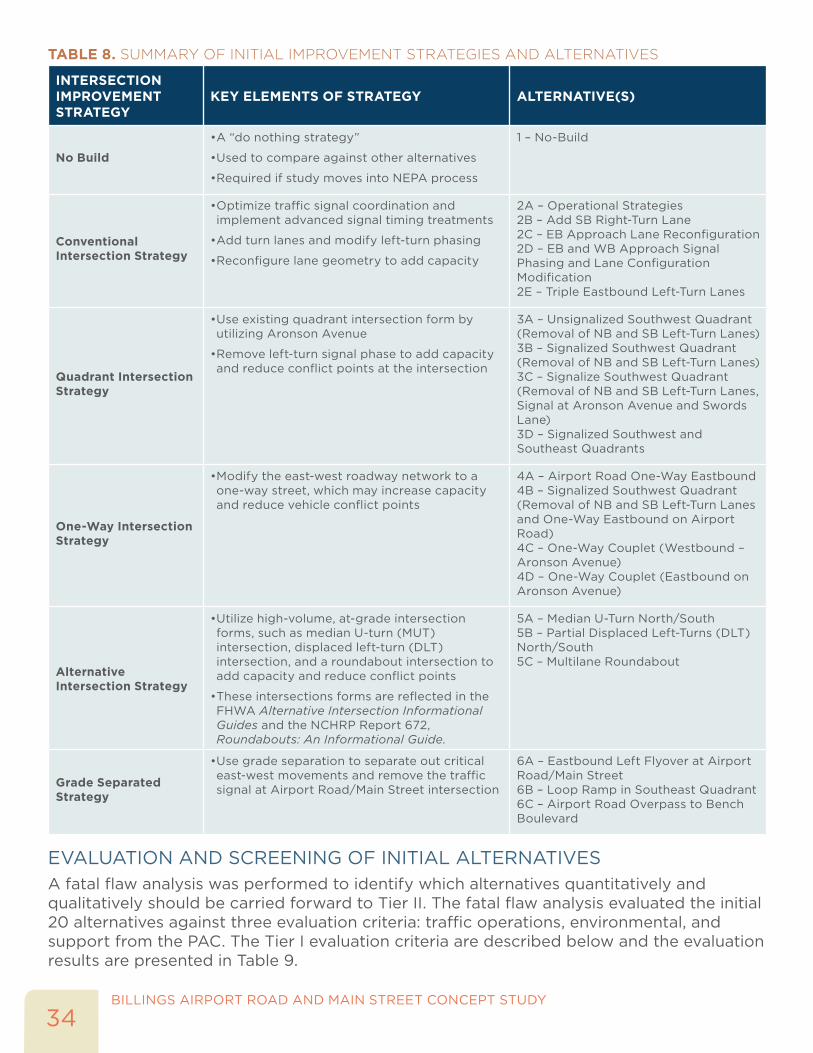
TIER I – INITIAL ALTERNATIVES AND EVALUATIONThe initial alternatives were developed based on the identified need at the Airport Road and Main Street intersection. The alternatives seek to address the future traffic patterns and operational deficiency, safety performance, movement of freight on the two corridors, and connectivity to businesses and land uses adjacent to the intersection. Twenty initial alternatives were developed by the project team and PAC for the Airport Road and Main Street intersection. The initial alternatives fall within the following operational and improvement strategies outlined in Table 8.
BILLINGS AIRPORT ROAD AND MAIN STREET CONCEPT STUDY
34
TABLE 8. SUMMARY OF INITIAL IMPROVEMENT STRATEGIES AND ALTERNATIVES
INTERSECTION IMPROVEMENT STRATEGY
KEY ELEMENTS OF STRATEGY ALTERNATIVE(S)
No Build
• A “do nothing strategy”
• Used to compare against other alternatives
• Required if study moves into NEPA process
1 – No-Build
Conventional Intersection Strategy
• Optimize traffic signal coordination and implement advanced signal timing treatments
• Add turn lanes and modify left-turn phasing
• Reconfigure lane geometry to add capacity
2A – Operational Strategies2B – Add SB Right-Turn Lane2C – EB Approach Lane Reconfiguration2D – EB and WB Approach Signal Phasing and Lane Configuration Modification2E – Triple Eastbound Left-Turn Lanes
Quadrant Intersection Strategy
• Use existing quadrant intersection form by utilizing Aronson Avenue
• Remove left-turn signal phase to add capacity and reduce conflict points at the intersection
3A – Unsignalized Southwest Quadrant (Removal of NB and SB Left-Turn Lanes)3B – Signalized Southwest Quadrant (Removal of NB and SB Left-Turn Lanes)3C – Signalize Southwest Quadrant (Removal of NB and SB Left-Turn Lanes, Signal at Aronson Avenue and Swords Lane)3D – Signalized Southwest and Southeast Quadrants
One-Way Intersection Strategy
• Modify the east-west roadway network to a one-way street, which may increase capacity and reduce vehicle conflict points
4A – Airport Road One-Way Eastbound4B – Signalized Southwest Quadrant (Removal of NB and SB Left-Turn Lanes and One-Way Eastbound on Airport Road)4C – One-Way Couplet (Westbound – Aronson Avenue)4D – One-Way Couplet (Eastbound on Aronson Avenue)
Alternative Intersection Strategy
• Utilize high-volume, at-grade intersection forms, such as median U-turn (MUT) intersection, displaced left-turn (DLT) intersection, and a roundabout intersection to add capacity and reduce conflict points
• These intersections forms are reflected in the FHWA Alternative Intersection Informational Guides and the NCHRP Report 672, Roundabouts: An Informational Guide.
5A – Median U-Turn North/South5B – Partial Displaced Left-Turns (DLT) North/South5C – Multilane Roundabout
Grade Separated Strategy
• Use grade separation to separate out critical east-west movements and remove the traffic signal at Airport Road/Main Street intersection
6A – Eastbound Left Flyover at Airport Road/Main Street6B – Loop Ramp in Southeast Quadrant6C – Airport Road Overpass to Bench Boulevard
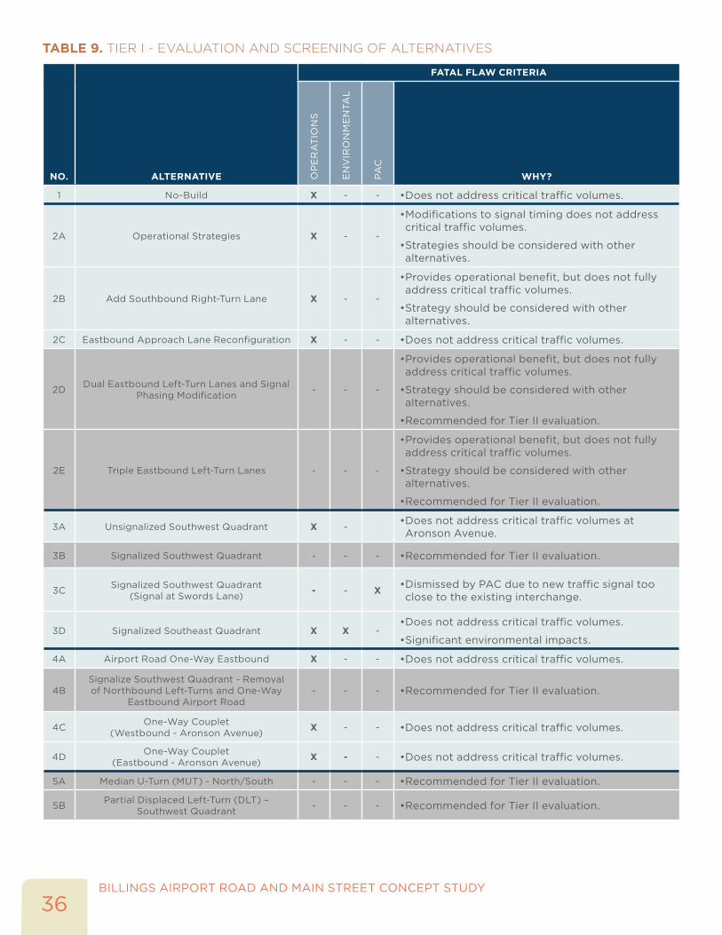
EVALUATION AND SCREENING OF INITIAL ALTERNATIVESA fatal flaw analysis was performed to identify which alternatives quantitatively and qualitatively should be carried forward to Tier II. The fatal flaw analysis evaluated the initial 20 alternatives against three evaluation criteria: traffic operations, environmental, and support from the PAC. The Tier I evaluation criteria are described below and the evaluation results are presented in Table 9.

35BILLINGS AIRPORT ROAD AND MAIN STREET CONCEPT STUDY
TRAFFIC OPERATIONS - DOES THE ALTERNATIVE ACCOMMODATE THE FUTURE YEAR 2040 CRITICAL VOLUMES?
An operational analysis was performed for the 20 alternatives highlighted in Table 8 using CAP-X and Synchro 8 traffic analysis software tools. Alternatives that were projected to operate at a LOS E or better and an intersection volume-to-capacity ratio of less than or equal to 1.10 during both the weekday a.m. and p.m. peak periods were considered operationally acceptable in the year 2040. All other alternatives were dismissed based on the operational criteria, except for Alternatives 2D and 2E as they are low cost alternatives that could be considered potential near-term improvements, if desired by MDT.
ENVIRONMENTAL - DOES THE ALTERNATIVE HAVE A SIGNIFICANT IMPACT TO AN ENVIRONMENTAL RESOURCE OR TOPOGRAPHICAL CONSTRAINT?
Using information from the Environmental Scan, an evaluation was performed to identify if any of the alternatives would have a major impact to any of the 4(f) resources (e.g. cultural/historic and recreational resources) and/or floodplain areas. The alternative was considered a fatal flaw if it impacted an environmental resource (e.g. new structure would require work on or near the environmental resource). According to MDT, there is a historical resource (e.g. rock shelter and pictographs) located in the southeast quadrant of the Airport Road and Main Street intersection. The alternatives that included new structures and connections in this quadrant were considered a fatal flaw if it impacted an environmental resource.
Additionally, an assessment of the alternatives in relationship to the surrounding topography was analyzed as well. The northeast quadrant includes the Alkali Creek drainage area, Earl Guss Park and local trail system, and a significant grade change sloping away from the intersection, which becomes a challenge for any alternatives using this quadrant. The southeast quadrant has a significant grade change sloping away from the intersection, which becomes a challenge (e.g. high cost and additional right-of-way) for any of the alternatives using this quadrant for placement of structures. Alternatives were dismissed based on an alternative requiring placement of new structures in the southeast and northeast quadrants of the Airport Road and Main Street intersection.
PROJECT ADVISORY COMMITTEE -WAS THERE SUPPORT BY THE PAC?
The PAC identified Alternatives 3C and 5C as fatal flaws. Alternative 3C was considered to be fatally flawed due to the addition of a new signal on Airport Road in close proximity to the Airport Road/Main Street intersection. Alternative 5C was considered to be fatally flawed due to an operational deficiency and impacts to signal progression on Main Street with a multilane roundabout.
BILLINGS AIRPORT ROAD AND MAIN STREET CONCEPT STUDY
36
TABLE 9. TIER I - EVALUATION AND SCREENING OF ALTERNATIVES
NO. ALTERNATIVE
FATAL FLAW CRITERIA
OP
ER
AT
ION
S
EN
VIR
ON
ME
NTA
L
PA
C
WHY?
1 No-Build X - - • Does not address critical traffic volumes.
2A Operational Strategies X - -
• Modifications to signal timing does not address critical traffic volumes.
• Strategies should be considered with other alternatives.
2B Add Southbound Right-Turn Lane X - -
• Provides operational benefit, but does not fully address critical traffic volumes.
• Strategy should be considered with other alternatives.
2C Eastbound Approach Lane Reconfiguration X - - • Does not address critical traffic volumes.
2D Dual Eastbound Left-Turn Lanes and Signal Phasing Modification - - -
• Provides operational benefit, but does not fully address critical traffic volumes.
• Strategy should be considered with other alternatives.
• Recommended for Tier II evaluation.
2E Triple Eastbound Left-Turn Lanes - - -
• Provides operational benefit, but does not fully address critical traffic volumes.
• Strategy should be considered with other alternatives.
• Recommended for Tier II evaluation.
3A Unsignalized Southwest Quadrant X -• Does not address critical traffic volumes at Aronson Avenue.
3B Signalized Southwest Quadrant - - - • Recommended for Tier II evaluation.
3C Signalized Southwest Quadrant (Signal at Swords Lane) - - X • Dismissed by PAC due to new traffic signal too
close to the existing interchange.
3D Signalized Southeast Quadrant X X -• Does not address critical traffic volumes.
• Significant environmental impacts.
4A Airport Road One-Way Eastbound X - - • Does not address critical traffic volumes.
4BSignalize Southwest Quadrant - Removal of Northbound Left-Turns and One-Way
Eastbound Airport Road- - - • Recommended for Tier II evaluation.
4C One-Way Couplet (Westbound - Aronson Avenue) X - - • Does not address critical traffic volumes.
4D One-Way Couplet (Eastbound - Aronson Avenue) X - - • Does not address critical traffic volumes.
5A Median U-Turn (MUT) - North/South - - - • Recommended for Tier II evaluation.
5B Partial Displaced Left-Turn (DLT) – Southwest Quadrant - - - • Recommended for Tier II evaluation.

37BILLINGS AIRPORT ROAD AND MAIN STREET CONCEPT STUDY
NO. ALTERNATIVE
FATAL FLAW CRITERIA
OP
ER
AT
ION
S
EN
VIR
ON
ME
NTA
L
PA
C
WHY?
5C Multilane Roundabout X - X• Does not address critical traffic volumes.
• Dismissed by PAC due to operational deficiency and impacts to signal progression.
6A Eastbound Left Flyover at Airport Road/Main Street X X -
• Significant impacts to Main Street, alignment, and traffic signal at Lake Elmo Drive
• Significant environmental impacts.
6B Loop Ramp in Southeast Quadrant - X - • Significant environmental impacts.
6C Airport Road Overpass to Bench Boulevard X X -
• Does not address critical traffic volumes.
• Significant environmental impacts.
Based on the Tier I screening shown In Table 9, six alternatives (highlighted in gray shading) and the no build alternative were carried forward to Tier II.
TIER II – REFINED ALTERNATIVES AND EVALUATIONSeven alternatives were identified for further evaluation in Tier II, which included:
• Alternative 1 – No Build
• Alternative 2D – Dual Eastbound Left-Turn Lanes and Signal Phasing Modification
• Alternative 2E – Triple Eastbound Left-Turn Lanes and Signal Phasing Modification
• Alternative 3B – Signalized Southwest Quadrant
• Alternative 4B - Signalized Southwest Quadrant and One-Way Eastbound on E. Airport Road
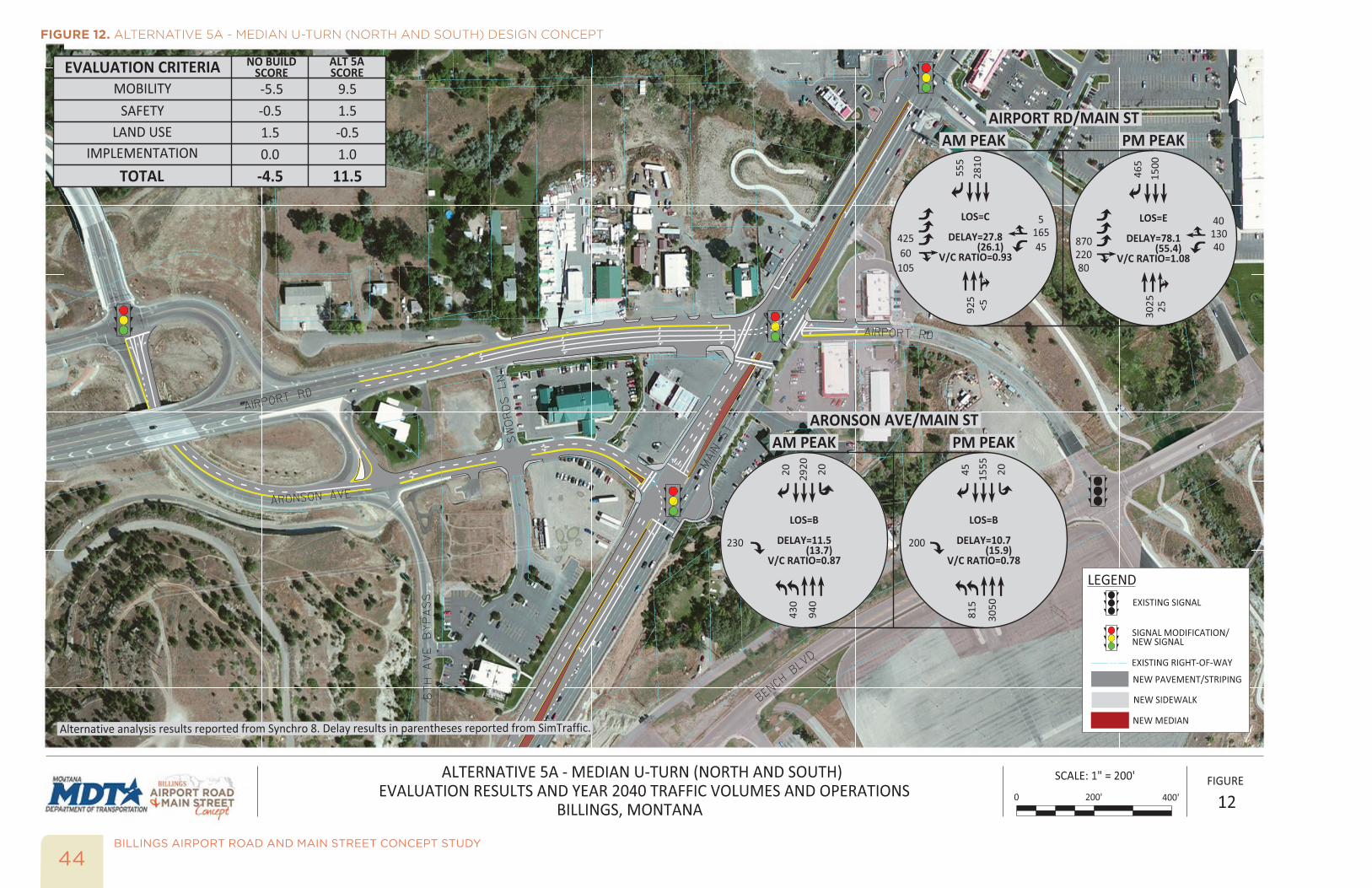
• Alternative 5A – Median U-Turn (North and South)
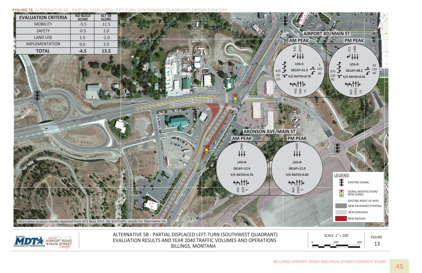
• Alternative 5B – Partial Displaced Left-Turn (Southwest Quadrant)
In Tier II, the seven alternatives were refined into concept designs, analyzed in more detail, and evaluated based on the evaluation criteria presented in Table 2. The analysis methodology, design criteria, and concept designs are discussed in the remainder of this section.
ANALYSIS METHODOLOGYAn updated operational analysis was performed for all of the alternatives using Synchro 8 and SIMTraffic traffic analysis software tools, except for Alternative 5B – Partial Displaced Left-Turn (SW Quadrant). These two software tools do not have the capability of modeling a displaced left-turn intersection in an effective manner. The upcoming 2015 Highway Capacity Manual (HCM) includes a methodology for analyzing alternative intersection forms, including the displaced left-turn intersection. McTrans, the software developer of the Highway Capacity Software (HCS) has incorporated a beta version of the HCS with the displaced left-turn intersection analysis tool. This beta version was used to analyze
BILLINGS AIRPORT ROAD AND MAIN STREET CONCEPT STUDY
38
the displaced left-turn intersection alternative and then the analysis was checked for reasonableness with a critical movement analysis.
The Synchro 8 operational analysis was used in the Tier I evaluation, but further refined based on updated geometry for each alternative. Delay, level of service, volume-to-capacity ratio, and 95th percentile queue lengths were obtained from the Synchro operational models. SimTraffic, a microsimulation tool was used to assess the alternatives in a dynamic environment. Ten simulation runs were performed and the average total delay by intersection was reported for each alternative. Additionally, the queuing and blocking reports from each alternative’s SimTraffic runs was used to determine appropriate turn-lane lengths within the alternative.
Each alternative was analyzed under year 2040 traffic conditions during the weekday a.m. and p.m. peak hours. The operational analysis included the following assumptions: year 2040 traffic volumes during the weekday a.m. and p.m. peak hours, optimized signal timings, and a peak hour factor of 1.0 (given the 20-year planning horizon).
DESIGN CRITERIA FOR CONCEPT DEVELOPMENTChapter 2 of the Montana Department of Transportation (MDT) Road Design Manual outlined the basic design controls for the roadways within the study area. The MDT Functional Classification Map defines Main Street and Airport Road as urban principal arterials. Based on the classification of these roadways, a design speed of 40 mph was used in the development of the design concepts. Alternatives that included roadway widening adhered to the minimum travel lane width of 12 feet. Because of the high volume of heavy vehicles, MDT verified the WB-67 as the design vehicle. Design concepts that included lane markings, channelization, additional turn lanes, and improvements to pedestrian crosswalks referenced design standards from Chapter 19 of the MDT Traffic Engineering Manual. Additionally, A Policy on Geometric Design of Highways and Streets, 6th Edition by the American Association of State Highway and Transportation (AASHTO) was used as a supportive reference manual during the design of each alternative.
Right-of-way and parcel information was obtained from Yellowstone County and verified by MDT using previous studies and design work (e.g. 6th Ave N to Bench Blvd. - BLGS, Billings - Airport Road) within the study area.
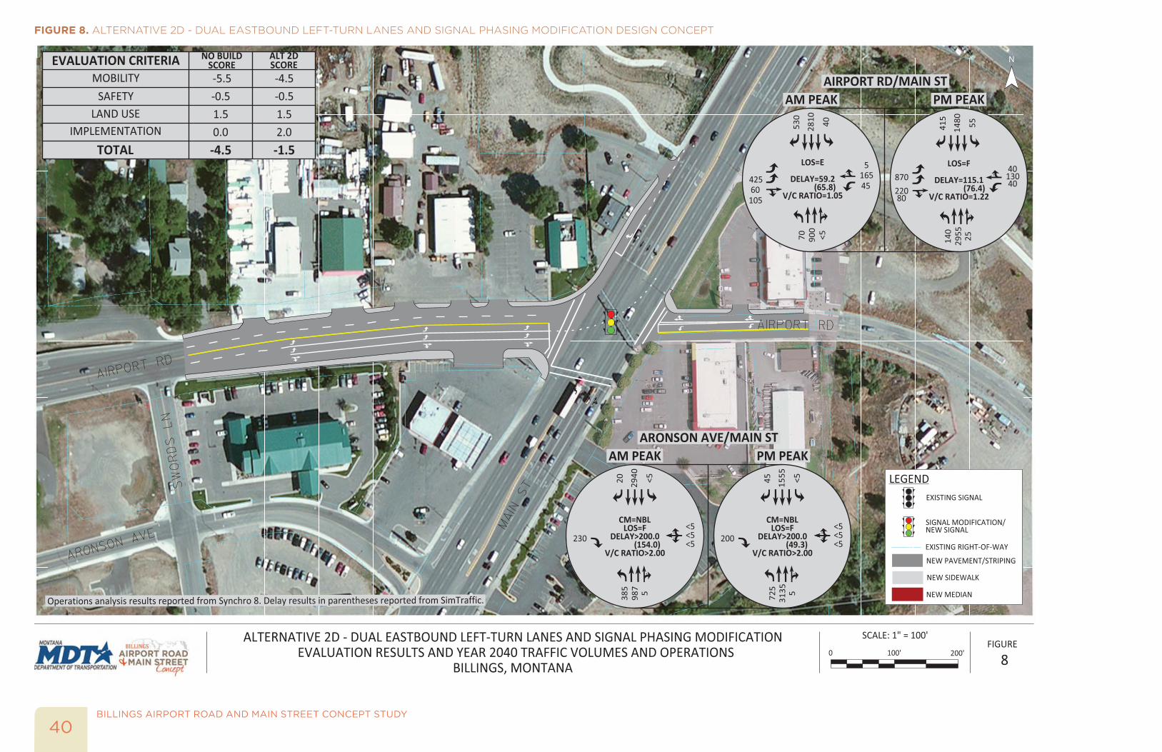
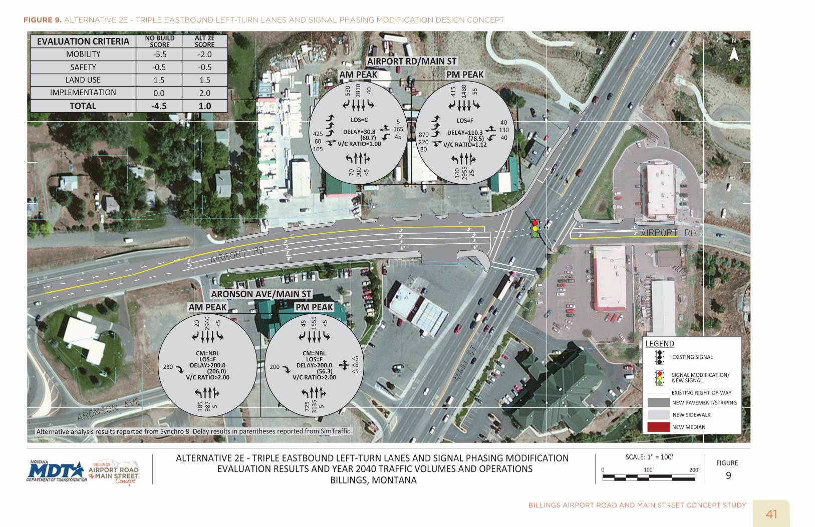
CONCEPT DESIGNS OF THE TIER II ALTERNATIVESDesign concepts were developed for the seven alternatives in MicroStation using the operational analysis results and design criteria. Figure 7, Figure 8, Figure 9, Figure 10, Figure 11, Figure 12, and Figure 13 show the design concepts, year 2040 traffic volumes and operations, and evaluation scoring results for each Tier II alternative.
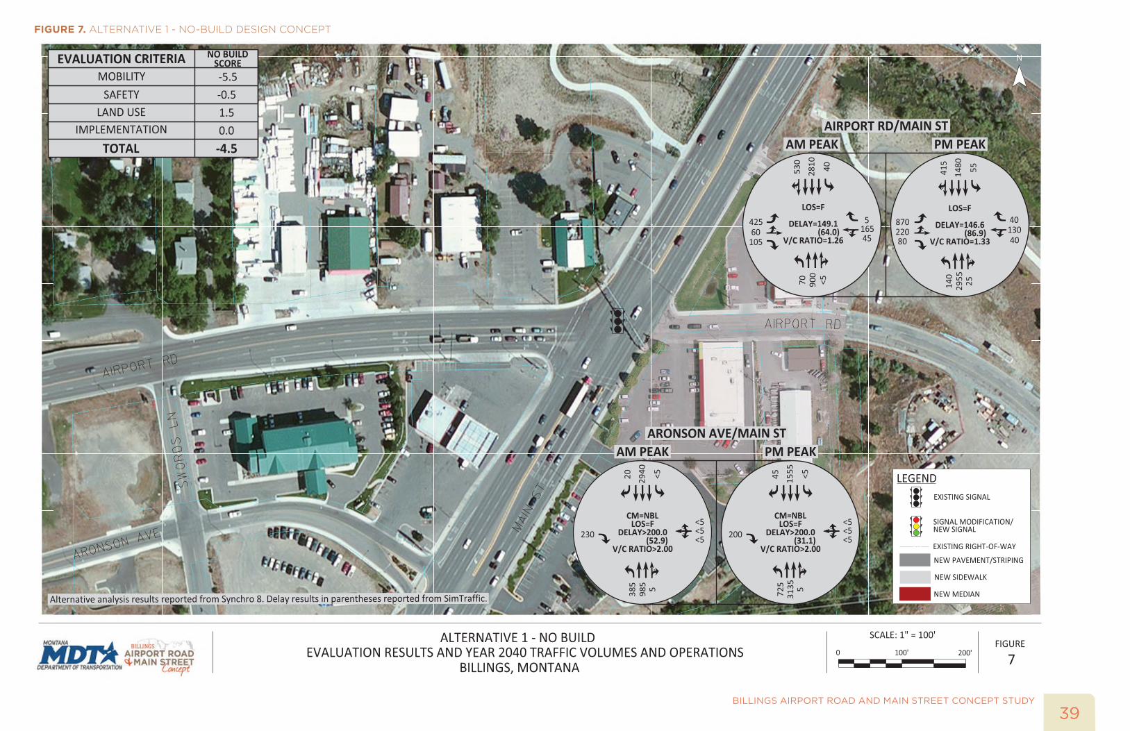
39BILLINGS AIRPORT ROAD AND MAIN STREET CONCEPT STUDY
FIGURE 7. ALTERNATIVE 1 - NO-BUILD DESIGN CONCEPT
BILLINGS AIRPORT ROAD AND MAIN STREET CONCEPT STUDY
40
FIGURE 8. ALTERNATIVE 2D - DUAL EASTBOUND LEFT-TURN LANES AND SIGNAL PHASING MODIFICATION DESIGN CONCEPT
41BILLINGS AIRPORT ROAD AND MAIN STREET CONCEPT STUDY
FIGURE 9. ALTERNATIVE 2E - TRIPLE EASTBOUND LEFT-TURN LANES AND SIGNAL PHASING MODIFICATION DESIGN CONCEPT

BILLINGS AIRPORT ROAD AND MAIN STREET CONCEPT STUDY
42
FIGURE 10. ALTERNATIVE 3B - SIGNALIZED SOUTHWEST QUADRANT DESIGN CONCEPT

43BILLINGS AIRPORT ROAD AND MAIN STREET CONCEPT STUDY
FIGURE 11. ALTERNATIVE 4B - SIGNALIZED SOUTHWEST QUANDRANT (ONE-WAY EASTBOUND ON E AIRPORT RD) DESIGN CONCEPT
BILLINGS AIRPORT ROAD AND MAIN STREET CONCEPT STUDY
44
FIGURE 12. ALTERNATIVE 5A - MEDIAN U-TURN (NORTH AND SOUTH) DESIGN CONCEPT
45BILLINGS AIRPORT ROAD AND MAIN STREET CONCEPT STUDY
FIGURE 13. ALTERNATIVE 5B - PARTIAL DISPLACED LEFT-TURN (SOUTHWEST QUADRANT) DESIGN CONCEPT

BILLINGS AIRPORT ROAD AND MAIN STREET CONCEPT STUDY
46
This page intentionally left blank
47BILLINGS AIRPORT ROAD AND MAIN STREET CONCEPT STUDY
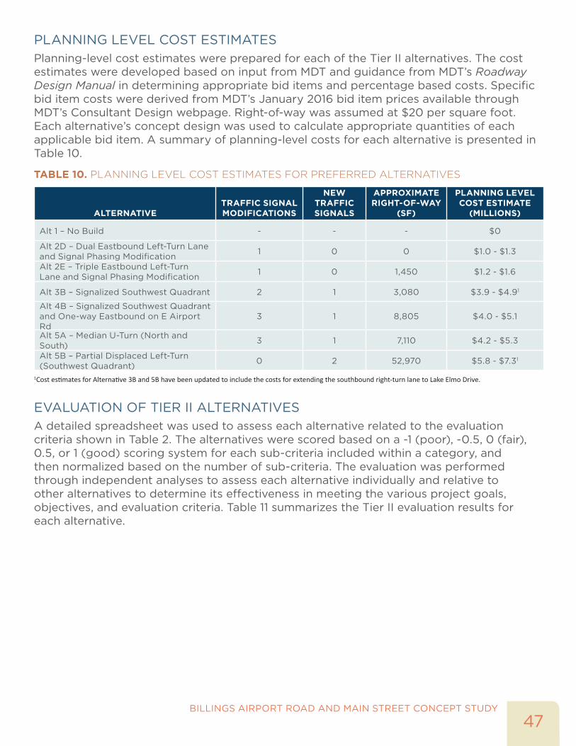
PLANNING LEVEL COST ESTIMATESPlanning-level cost estimates were prepared for each of the Tier II alternatives. The cost estimates were developed based on input from MDT and guidance from MDT’s Roadway Design Manual in determining appropriate bid items and percentage based costs. Specific bid item costs were derived from MDT’s January 2016 bid item prices available through MDT’s Consultant Design webpage. Right-of-way was assumed at $20 per square foot. Each alternative’s concept design was used to calculate appropriate quantities of each applicable bid item. A summary of planning-level costs for each alternative is presented in Table 10.
TABLE 10. PLANNING LEVEL COST ESTIMATES FOR PREFERRED ALTERNATIVES
ALTERNATIVETRAFFIC SIGNAL MODIFICATIONS
NEW TRAFFIC SIGNALS
APPROXIMATE RIGHT-OF-WAY
(SF)
PLANNING LEVEL COST ESTIMATE
(MILLIONS)
Alt 1 – No Build - - - $0
Alt 2D – Dual Eastbound Left-Turn Lane and Signal Phasing Modification 1 0 0 $1.0 - $1.3
Alt 2E – Triple Eastbound Left-Turn Lane and Signal Phasing Modification 1 0 1,450 $1.2 - $1.6
Alt 3B – Signalized Southwest Quadrant 2 1 3,080 $3.9 - $4.91
Alt 4B – Signalized Southwest Quadrant and One-way Eastbound on E Airport Rd
3 1 8,805 $4.0 - $5.1
Alt 5A – Median U-Turn (North and South) 3 1 7,110 $4.2 - $5.3
Alt 5B – Partial Displaced Left-Turn (Southwest Quadrant) 0 2 52,970 $5.8 - $7.31
1Cost estimates for Alternative 3B and 5B have been updated to include the costs for extending the southbound right-turn lane to Lake Elmo Drive.
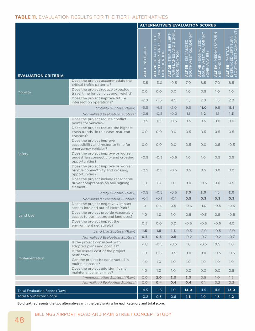
EVALUATION OF TIER II ALTERNATIVESA detailed spreadsheet was used to assess each alternative related to the evaluation criteria shown in Table 2. The alternatives were scored based on a -1 (poor), -0.5, 0 (fair), 0.5, or 1 (good) scoring system for each sub-criteria included within a category, and then normalized based on the number of sub-criteria. The evaluation was performed through independent analyses to assess each alternative individually and relative to other alternatives to determine its effectiveness in meeting the various project goals, objectives, and evaluation criteria. Table 11 summarizes the Tier II evaluation results for each alternative.
BILLINGS AIRPORT ROAD AND MAIN STREET CONCEPT STUDY
48
TABLE 11. EVALUATION RESULTS FOR THE TIER II ALTERNATIVES
EVALUATION CRITERIA
ALTERNATIVE'S EVALUATION SCORES
ALT
1 -
NO
BU
ILD
ALT
2D
- D
UA
L E
B L
EF
T-T
UR
N L
AN
ES
AN
D S
IGN
AL
M
OD
IFIC
AT
ION
ALT
2E
- T
RIP
LE
EB
LE
FT-
TU
RN
LA
NE
S A
ND
SIG
NA
L
MO
DIF
ICA
TIO
N
ALT
3B
- S
IGN
AL
IZE
D
SO
UT
HW
ES
T Q
UA
DR
AN
T
ALT
4B
- S
IGN
AL
IZE
D
SO
UT
HW
ES
T Q
UA
DR
AN
T
(ON
E-W
AY
EB
)
ALT
5A
- M
ED
IAN
U-T
UR
N
(NB
AN
D S
B)
ALT
5B
- P
AR
TIA
L
DIS
PL
AC
ED
LE
FT-
TU
RN
(S
OU
TH
WE
ST
QU
AD
RA
NT
)
Mobility
Does the project accommodate the critical traffic patterns? -3.5 -3.0 -0.5 7.0 8.5 7.0 8.5
Does the project reduce expected travel time for vehicles and freight? 0.0 0.0 0.0 1.0 0.5 1.0 1.0
Does the project improve future intersection operations? -2.0 -1.5 -1.5 1.5 2.0 1.5 2.0
Mobility Subtotal (Raw) -5.5 -4.5 -2.0 9.5 11.0 9.5 11.5
Normalized Evaluation Subtotal -0.6 -0.5 -0.2 1.1 1.2 1.1 1.3
Safety
Does the project reduce conflict points for vehicles? -0.5 -0.5 -0.5 0.5 0.5 0.0 0.0
Does the project reduce the highest crash trends (in this case, rear-end crashes)?
0.0 0.0 0.0 0.5 0.5 0.5 0.5
Does the project improve accessibility and response time for emergency vehicles?
0.0 0.0 0.0 0.5 0.0 0.5 -0.5
Does the project improve or worsen pedestrian connectivity and crossing opportunities?
-0.5 -0.5 -0.5 1.0 1.0 0.5 0.5
Does the project improve or worsen bicycle connectivity and crossing opportunities?
-0.5 -0.5 -0.5 0.5 0.5 0.0 0.0
Does the project include reasonable driver comprehension and signing element?
1.0 1.0 1.0 0.0 -0.5 0.0 0.5
Safety Subtotal (Raw) -0.5 -0.5 -0.5 3.0 2.0 1.5 2.0
Normalized Evaluation Subtotal -0.1 -0.1 -0.1 0.5 0.3 0.3 0.3
Land Use
Does the project negatively impact access into and out of MetraPark? 0 0.5 0.5 -0.5 -1.0 -0.5 -0.5
Does the project provide reasonable access to businesses and land uses? 1.0 1.0 1.0 0.5 -0.5 0.5 -0.5
Does the project impact the environment negatively? 0.5 0.0 0.0 -0.5 -0.5 -0.5 -1.0
Land Use Subtotal (Raw) 1.5 1.5 1.5 -0.5 -2.0 -0.5 -2.0
Normalized Evaluation Subtotal 0.5 0.5 0.5 -0.2 -0.7 -0.2 -0.7
Implementation
Is the project consistent with adopted plans and policies? -1.0 -0.5 -0.5 1.0 -0.5 0.5 1.0
Is the overall cost of the project restrictive? 1.0 0.5 0.5 0.0 0.0 -0.5 -0.5
Can the project be constructed in multiple phases? -1.0 1.0 1.0 1.0 1.0 1.0 1.0
Does the project add significant maintenance lane miles? 1.0 1.0 1.0 0.0 0.0 0.0 0.5
Implementation Subtotal (Raw) 0.0 2.0 2.0 2.0 0.5 1.0 1.5Normalized Evaluation Subtotal 0.0 0.4 0.4 0.4 0.1 0.2 0.3
Total Evaluation Score (Raw) -4.5 -1.5 1.0 14.0 11.5 11.5 13.0
Total Normalized Score -0.2 0.3 0.6 1.8 1.0 1.3 1.2
Bold text represents the two alternatives with the best ranking for each category and total score.
49BILLINGS AIRPORT ROAD AND MAIN STREET CONCEPT STUDY
As shown in Table 11, Alternatives 2E, 3B, 4B, 5A, and 5B all have a positive raw score from the evaluation. Alternatives 1 and 2D have a negative raw score from the evaluation. Alternatives 3B, 4B, 5A, and 5B range from 11.5 to 14 in total raw score. Below is a summary discussion of each alternative and the advantages/disadvantages based on the evaluation categories:
• Alternative 1 – No Build: This alternative includes no improvements to the intersection. The alternative scores poor in the mobility and safety categories since there are no geometric improvements at the intersection. The alternative scores good and fair in the land use and implementation categories, since it has minimal impact to adjacent businesses, low cost, and low maintenance.
• Alternative 2D – Dual Eastbound Left-Turn Lanes and Signal Phasing Modification: This alternative includes minor geometric and phasing improvements and has similar scores to the no-build alternative.
• Alternative 2E – Triple Eastbound Left-Turn Lanes and Signal Phasing Modification: This alternative includes an additional left-turn lane on the eastbound approach. This improvement provides an operational benefit to the eastbound left-turn and some benefit to the northbound and southbound through movements as more green time can be allocated to these critical movements. The evaluation scores for this alternative are better than Alternatives 1 and 2D, but still ranks poorly amongst all of the alternatives as a viable long-term solution at this intersection.
• Alternative 3B – Signalized Southwest Quadrant: This alternative includes significant changes to the connectivity and routing of movements at the Airport Road/Main Street intersection. A key element of this alternative is using the available capacity of Aronson Avenue and the existing interchange to route vehicles through the area. This alternatives ranks fair to good for mobility, as the intersection operations are under or just at capacity in the year 2040. It scores best in the safety and implementation categories, as it generally maintains or enhances connectivity and uses existing infrastructure to have moderate costs. For land use, the alternative ranks in the middle with moderate impacts to adjacent businesses, routing for MetraPark, and right-of way.
• Alternative 4B - Signalized Southwest Quadrant and One-Way Eastbound on E. Airport Road: This alternative includes significant changes to the connectivity and routing of movements at the Airport Road/Main Street intersection, including removing the westbound movements at the Airport Road/Main Street intersection. Overall, this alternative has some similarity to Alternative 3B in terms of mobility and safety performance. However, it ranks poorly in the land use and implementation categories, due to significant impacts to routing and access for MetraPark and businesses, as well as consistency with local connectivity policies.
• Alternative 5A – Median U-Turn (North and South): This alternative includes significant changes to the connectivity and routing of movements at the Airport Road/Main Street intersection, including providing U-turn movements at Aronson Avenue and Lake Elmo Drive. This alternative has a similar performance to Alternative 3B for mobility and land use. However, it ranks worse in the safety and implementation categories, due to a lower number of pedestrian/bicycle crossings and right-of-way impacts with the U-turn movements and loons.
BILLINGS AIRPORT ROAD AND MAIN STREET CONCEPT STUDY
50
• Alternative 5B – Partial Displaced Left-Turn (Southwest Quadrant): This alternative includes significant changes at the Aronson Avenue/Main Street and Airport Road/Main Street intersections. This alternative intersection form would be the first in the State of Montana. This alternative is the top performer in the mobility category, as it provides an under capacity intersection operation in the year 2040. It scores fair in safety and implementation, as it has the lowest number of vehicle to vehicle conflict points and maintains route continuity between Airport Road and Main Street. This alternative is anticipated to have the highest cost, as it has major impacts to one parcel in the southwest quadrant of the Airport Road/Main Street intersection.
In summary, Alternative 1, 3B, and 5B were carried forward to Tier III based on the evaluation and input from the PAC.
TIER III – RECOMMENDED ALTERNATIVESThe Tier III process included refined development of the concept designs, modeling each alternative using microsimulation (VISSIM), and gathering comments from the Policy Coordinating Committee (PCC), PAC, and public at the PIM. The three alternatives are listed below:
• Alternative 1 – No Build
• Alternative 3B – Signalized Southwest Quadrant
• Alternative 5B – Partial Displaced Left-Turn (Southwest Quadrant)
REFINED CONCEPT DESIGN AND CONSIDERATIONSThe refined concept design includes extending the southbound right turn lane at the Airport Road/Main Street intersection to the Lake Elmo Drive intersection. The PAC agreed that the operational benefits of the extension for the southbound right-turn lane would outweigh additional cost and should be included with Alternatives 3B and 5B. The revised Alternative 3B concept design with the southbound right-turn lane is illustrated in Figure 14. The revised Alternative 5B concept design is illustrated in Figure 15.

51BILLINGS AIRPORT ROAD AND MAIN STREET CONCEPT STUDY
FIGURE 14. ALTERNATIVE 3B REFINED CONCEPT DESIGN
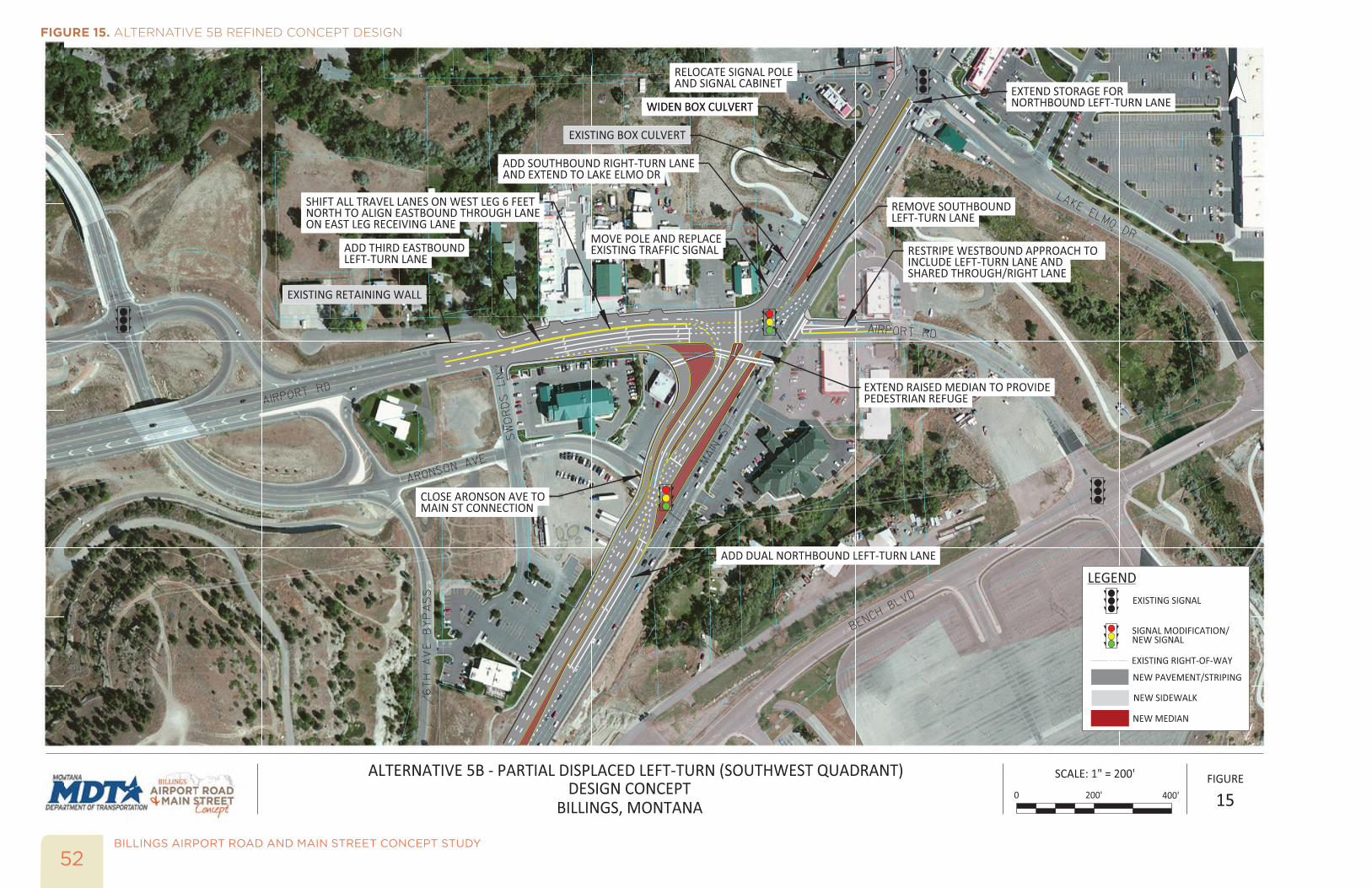
BILLINGS AIRPORT ROAD AND MAIN STREET CONCEPT STUDY
52
FIGURE 15. ALTERNATIVE 5B REFINED CONCEPT DESIGN
53BILLINGS AIRPORT ROAD AND MAIN STREET CONCEPT STUDY
Approximately 23 feet of roadway widening would need to occur on the west side of Main Street to accommodate standard lane, curb and gutter, and sidewalk widths. Widening costs include the two box culverts which currently serve as an underpass for the Jim Dutcher Trail and Alkali Creek. The extension of the culvert would impact Alkali Creek, which is a natural drainage feature with fishery resources. A Stream Protection Authorization and Section 404 permit would be required for this work. Additionally, timing restrictions on vegetation removal in accordance with the Migratory Bird Treaty Act would also be likely. In the concept designs, the southbound right-turn lane was extended to Lake Elmo Drive for both alternatives.
MICROSIMULATION (VISSIM) TRAFFIC MODELSAs part of the Tier III evaluation, the operational performance for Alternative 3B and 5B was evaluated further by developing a microsimulation model for each alternative. The microsimulation models were developed for the future year (2040) weekday a.m. and p.m. peak hours. For comparison purposes and for display at the PIM, a microsimulation model was developed for existing conditions.
The microsimulation models were created using PTV VISSIM (version 8.00-006) and were calibrated to local driving conditions to provide a comparison of traffic operations between the two alternatives. Calibration for the existing conditions model was based on reaching target thresholds of model-reported results versus field-measured data. The model was calibrated based on saturated flow rate, traffic volumes and visual accuracy with field conditions. Lane geometry, including lane widths and configurations at the existing intersections and driveways were based on aerial photographs, as-built data provided by MDT and aligned with the concept designs for Alternatives 3B and 5B. The VISSIM model was updated to reflect the extension of the southbound right-turn lane to Lake Elmo Drive for both alternatives.
All microsimulation models included traffic counts and signal timing parameters at each of the study intersections for the appropriate scenarios. Year 2040 traffic volumes were used in the Alternative 3B and 5B models. Vehicle routing was determined based on the alternative, and a variety of heavy vehicles were used in model, including the WB-67 design vehicle. Travel speeds were based on posted speed limits, and were adjusted using reduced speed areas at locations where geometry required (i.e. turning vehicles at intersections). Example views of the VISSIM models for Alternative 3B and 5B are shown in Exhibit 13 and Exhibit 14.
EXHIBIT 13. ALTERNATIVE 3B PM PEAK HOUR VISSIM MODEL
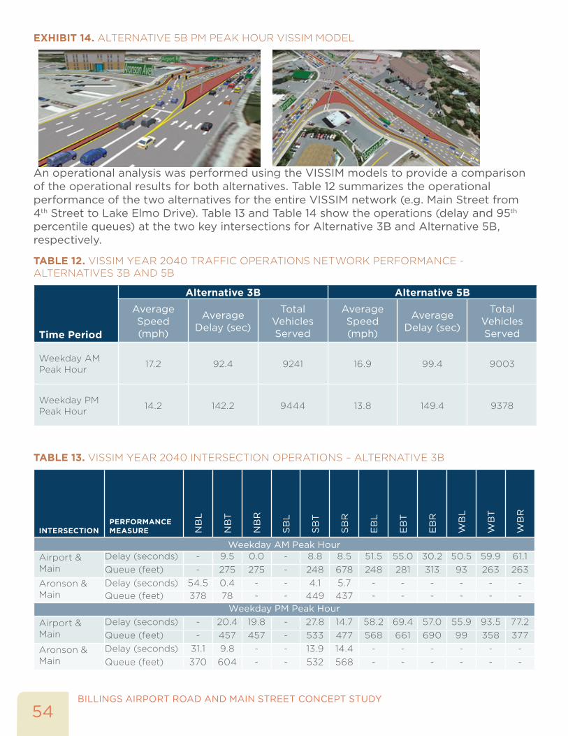
BILLINGS AIRPORT ROAD AND MAIN STREET CONCEPT STUDY
54
EXHIBIT 14. ALTERNATIVE 5B PM PEAK HOUR VISSIM MODEL
An operational analysis was performed using the VISSIM models to provide a comparison of the operational results for both alternatives. Table 12 summarizes the operational performance of the two alternatives for the entire VISSIM network (e.g. Main Street from 4th Street to Lake Elmo Drive). Table 13 and Table 14 show the operations (delay and 95th percentile queues) at the two key intersections for Alternative 3B and Alternative 5B, respectively.
TABLE 12. VISSIM YEAR 2040 TRAFFIC OPERATIONS NETWORK PERFORMANCE - ALTERNATIVES 3B AND 5B
Time Period
Alternative 3B Alternative 5BAverage Speed (mph)
Average Delay (sec)
Total Vehicles Served
Average Speed (mph)
Average Delay (sec)
Total Vehicles Served
Weekday AM Peak Hour 17.2 92.4 9241 16.9 99.4 9003
Weekday PM Peak Hour 14.2 142.2 9444 13.8 149.4 9378
TABLE 13. VISSIM YEAR 2040 INTERSECTION OPERATIONS – ALTERNATIVE 3B
INTERSECTIONPERFORMANCE MEASURE N
BL
NB
T
NB
R
SB
L
SB
T
SB
R
EB
L
EB
T
EB
R
WB
L
WB
T
WB
R
Weekday AM Peak HourAirport & Main
Delay (seconds) - 9.5 0.0 - 8.8 8.5 51.5 55.0 30.2 50.5 59.9 61.1Queue (feet) - 275 275 - 248 678 248 281 313 93 263 263
Aronson & Main
Delay (seconds) 54.5 0.4 - - 4.1 5.7 - - - - - -Queue (feet) 378 78 - - 449 437 - - - - - -
Weekday PM Peak Hour
Airport & Main
Delay (seconds) - 20.4 19.8 - 27.8 14.7 58.2 69.4 57.0 55.9 93.5 77.2Queue (feet) - 457 457 - 533 477 568 661 690 99 358 377
Aronson & Main
Delay (seconds) 31.1 9.8 - - 13.9 14.4 - - - - - -Queue (feet) 370 604 - - 532 568 - - - - - -
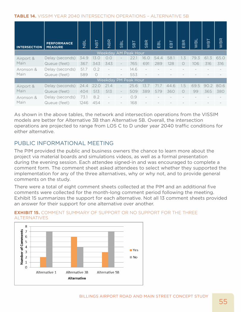
55BILLINGS AIRPORT ROAD AND MAIN STREET CONCEPT STUDY
TABLE 14. VISSIM YEAR 2040 INTERSECTION OPERATIONS – ALTERNATIVE 5B
INTERSECTIONPERFORMANCE MEASURE N
BL
NB
T
NB
R
SB
L
SB
T
SB
R
EB
L
EB
T
EB
R
WB
L
WB
T
WB
R
Weekday AM Peak HourAirport & Main
Delay (seconds) 34.9 13.0 0.0 - 22.1 16.0 54.4 58.1 1.3 79.3 61.3 65.0Queue (feet) 367 343 343 - 765 691 289 128 0 106 316 316
Aronson & Main
Delay (seconds) 51.7 0.2 - - 14.6 - - - - - - -Queue (feet) 589 0 - - 553 - - - - - - -
Weekday PM Peak Hour
Airport & Main
Delay (seconds) 24.4 22.0 21.4 - 25.6 13.7 71.7 44.6 1.5 69.5 90.2 80.6Queue (feet) 404 513 513 - 509 389 579 360 0 99 365 380
Aronson & Main
Delay (seconds) 73.1 8.2 - - 0.9 - - - - - - -Queue (feet) 1246 454 - - 168 - - - - - - -
As shown in the above tables, the network and intersection operations from the VISSIM models are better for Alternative 3B than Alternative 5B. Overall, the intersection operations are projected to range from LOS C to D under year 2040 traffic conditions for either alternative.
PUBLIC INFORMATIONAL MEETINGThe PIM provided the public and business owners the chance to learn more about the project via material boards and simulations videos, as well as a formal presentation during the evening session. Each attendee signed-in and was encouraged to complete a comment form. The comment sheet asked attendees to select whether they supported the implementation for any of the three alternatives, why or why not, and to provide general comments on the study.
There were a total of eight comment sheets collected at the PIM and an additional five comments were collected for the month-long comment period following the meeting. Exhibit 15 summarizes the support for each alternative. Not all 13 comment sheets provided an answer for their support for one alternative over another.
EXHIBIT 15. COMMENT SUMMARY OF SUPPORT OR NO SUPPORT FOR THE THREE ALTERNATIVES
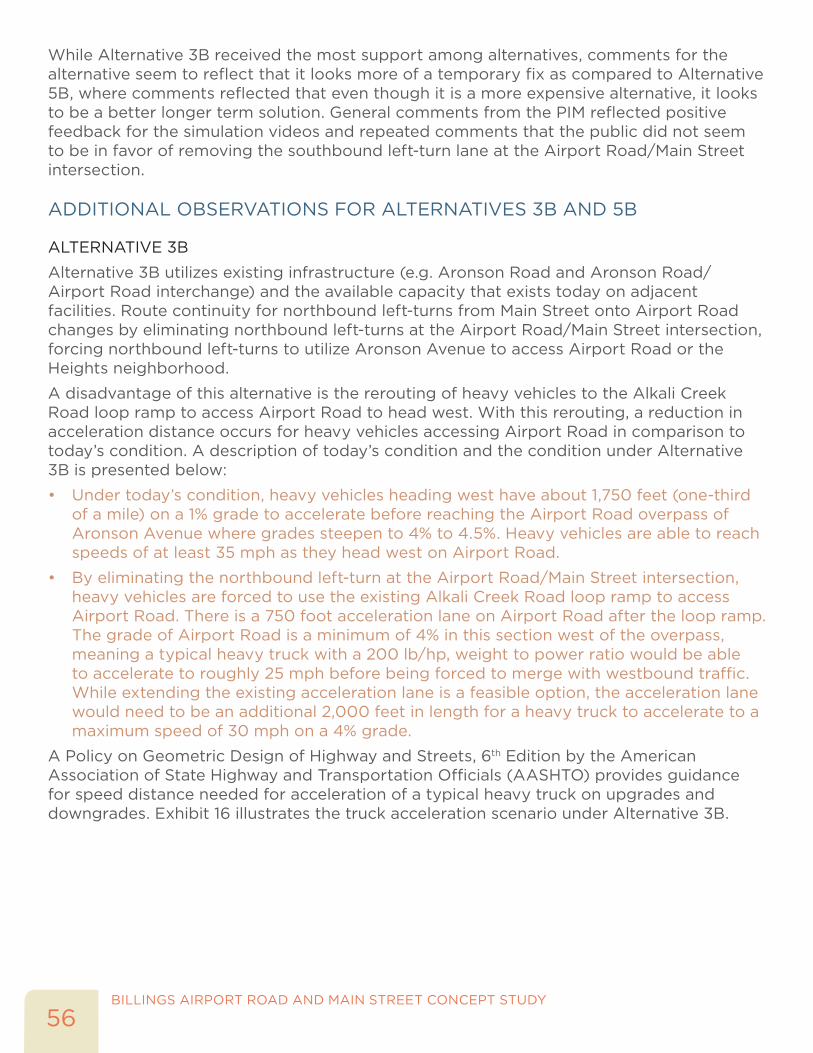
BILLINGS AIRPORT ROAD AND MAIN STREET CONCEPT STUDY
56
While Alternative 3B received the most support among alternatives, comments for the alternative seem to reflect that it looks more of a temporary fix as compared to Alternative 5B, where comments reflected that even though it is a more expensive alternative, it looks to be a better longer term solution. General comments from the PIM reflected positive feedback for the simulation videos and repeated comments that the public did not seem to be in favor of removing the southbound left-turn lane at the Airport Road/Main Street intersection.
ADDITIONAL OBSERVATIONS FOR ALTERNATIVES 3B AND 5B
ALTERNATIVE 3B
Alternative 3B utilizes existing infrastructure (e.g. Aronson Road and Aronson Road/Airport Road interchange) and the available capacity that exists today on adjacent facilities. Route continuity for northbound left-turns from Main Street onto Airport Road changes by eliminating northbound left-turns at the Airport Road/Main Street intersection, forcing northbound left-turns to utilize Aronson Avenue to access Airport Road or the Heights neighborhood.
A disadvantage of this alternative is the rerouting of heavy vehicles to the Alkali Creek Road loop ramp to access Airport Road to head west. With this rerouting, a reduction in acceleration distance occurs for heavy vehicles accessing Airport Road in comparison to today’s condition. A description of today’s condition and the condition under Alternative 3B is presented below:
• Under today’s condition, heavy vehicles heading west have about 1,750 feet (one-third of a mile) on a 1% grade to accelerate before reaching the Airport Road overpass of Aronson Avenue where grades steepen to 4% to 4.5%. Heavy vehicles are able to reach speeds of at least 35 mph as they head west on Airport Road.
• By eliminating the northbound left-turn at the Airport Road/Main Street intersection, heavy vehicles are forced to use the existing Alkali Creek Road loop ramp to access Airport Road. There is a 750 foot acceleration lane on Airport Road after the loop ramp. The grade of Airport Road is a minimum of 4% in this section west of the overpass, meaning a typical heavy truck with a 200 lb/hp, weight to power ratio would be able to accelerate to roughly 25 mph before being forced to merge with westbound traffic. While extending the existing acceleration lane is a feasible option, the acceleration lane would need to be an additional 2,000 feet in length for a heavy truck to accelerate to a maximum speed of 30 mph on a 4% grade.
A Policy on Geometric Design of Highway and Streets, 6th Edition by the American Association of State Highway and Transportation Officials (AASHTO) provides guidance for speed distance needed for acceleration of a typical heavy truck on upgrades and downgrades. Exhibit 16 illustrates the truck acceleration scenario under Alternative 3B.
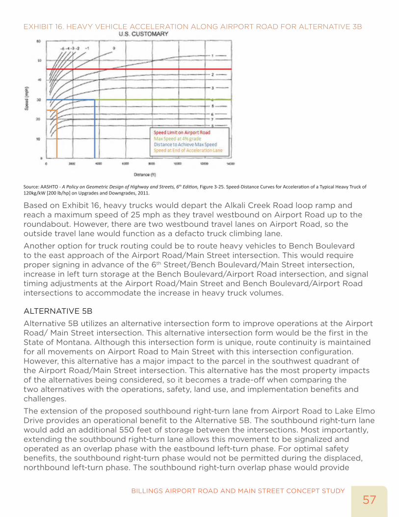
57BILLINGS AIRPORT ROAD AND MAIN STREET CONCEPT STUDY
EXHIBIT 16. HEAVY VEHICLE ACCELERATION ALONG AIRPORT ROAD FOR ALTERNATIVE 3B
Source: AASHTO - A Policy on Geometric Design of Highway and Streets, 6th Edition, Figure 3-25. Speed-Distance Curves for Acceleration of a Typical Heavy Truck of 120kg/kW [200 lb/hp] on Upgrades and Downgrades, 2011.
Based on Exhibit 16, heavy trucks would depart the Alkali Creek Road loop ramp and reach a maximum speed of 25 mph as they travel westbound on Airport Road up to the roundabout. However, there are two westbound travel lanes on Airport Road, so the outside travel lane would function as a defacto truck climbing lane.
Another option for truck routing could be to route heavy vehicles to Bench Boulevard to the east approach of the Airport Road/Main Street intersection. This would require proper signing in advance of the 6th Street/Bench Boulevard/Main Street intersection, increase in left turn storage at the Bench Boulevard/Airport Road intersection, and signal timing adjustments at the Airport Road/Main Street and Bench Boulevard/Airport Road intersections to accommodate the increase in heavy truck volumes.
ALTERNATIVE 5B
Alternative 5B utilizes an alternative intersection form to improve operations at the Airport Road/ Main Street intersection. This alternative intersection form would be the first in the State of Montana. Although this intersection form is unique, route continuity is maintained for all movements on Airport Road to Main Street with this intersection configuration. However, this alternative has a major impact to the parcel in the southwest quadrant of the Airport Road/Main Street intersection. This alternative has the most property impacts of the alternatives being considered, so it becomes a trade-off when comparing the two alternatives with the operations, safety, land use, and implementation benefits and challenges.
The extension of the proposed southbound right-turn lane from Airport Road to Lake Elmo Drive provides an operational benefit to the Alternative 5B. The southbound right-turn lane would add an additional 550 feet of storage between the intersections. Most importantly, extending the southbound right-turn lane allows this movement to be signalized and operated as an overlap phase with the eastbound left-turn phase. For optimal safety benefits, the southbound right-turn phase would not be permitted during the displaced, northbound left-turn phase. The southbound right-turn overlap phase would provide

BILLINGS AIRPORT ROAD AND MAIN STREET CONCEPT STUDY
58
adequate time for southbound right-turns to be processed through the intersection during both the weekday a.m. and p.m. peak hours. Additionally, the southbound right-turn phase could operate during some of the southbound and northbound through phases.
While the greatest challenge of Alternative 5B is the impact to existing right-of-way and adjacent land uses, Alternative 5B maintains route continuity and acceptable traffic operations at the Airport Road/Main Street and Aronson Avenue/Main Street intersections.

RECOMMENDED ALTERNATIVE AND IMPLEMENTATION

BILLINGS AIRPORT ROAD AND MAIN STREET CONCEPT STUDY
60
This page intentionally left blank.

61BILLINGS AIRPORT ROAD AND MAIN STREET CONCEPT STUDY
RECOMMENDED ALTERNATIVE AND IMPLEMENTATIONThe Tier III evaluation concluded that both Alternative 3B – Signalized Southwest Quadrant and Alternative 5B – Partial Displaced Left-Turn are viable alternatives for the Airport Road/Main Street intersection. Alternative 1 – No Build is not recommended to be carried forward as a long-term solution for the intersection; however, it is included in the alternatives pool as a basis for comparing impacts related to the build alternative.
In summary, both alternatives address the future operational deficiencies at the Airport Road/Main Street and Aronson Avenue/Main Street intersections. Both alternatives have their advantages and disadvantages in regards to property impacts and costs, route continuity, and heavy vehicle routing. Table 15 provides an overview of each alternative’s refined concept design and the advantages and disadvantages with each alternative.
TABLE 15. BENEFITS AND TRADEOFFS OF RECOMMENDED ALTERNATIVES
CATEGORY
ALTERNATIVE 3B ALTERNATIVE 5B
BENEFITS TRADEOFFS BENEFITS TRADEOFFS
Mobility
• LOS C and E during a.m. and p.m. peak hour, respectively (HCM)
• LOS C to D during a.m. and p.m. peak hours (VISSIM)
• Decreases travel time for vehicles and freight
• Maintains the high NB lefts at Aronson Avenue to the Heights
• Removes SB left-turn lane
• Potential vehicle queue spillback for SB through at new Aronson traffic signal
• NB left-turn route from Main Street to Airport Road is not intuitive
• LOS C and D during a.m. and p.m. peak hour, respectively
• LOS C to D during a.m. and p.m. peak hours (VISSIM)
• Maintains route continuity
• Decreases travel time for vehicles and freight
• Removes SB left-turn lane
• Long vehicle queue for NB left turn at new crossover traffic signal
• Potential vehicle queue spillback for SB through at new crossover traffic signal
• Relocates high NB lefts at Aronson Ave to Airport Rd
Safety
• Enhances pedestrian and bicycle connectivity
• New signalized crossing at Aronson Rd/Main St
• Increases traffic volumes on Aronson Avenue with the rerouting of the NB left-turn movement
• Eliminates some conflict points
• Restricts access to Aronson Ave for emergency vehicles
Land Use
• Minimal right-of-way impact
• No environmental impacts
• Minimal geographic constraints
• Restricts business access along Airport Rd
• No environmental impacts
• Minimal geographic constraints
• Restricts business access to Aronson Ave
• Impacts business on SW corner
• High right-of-way impacts
Implementation
• Consistent with adopted plans and policies
• Project can be constructed in multiple phases
• Community support for the project
• Adds additional lane miles for higher maintenance costs
• Consistent with adopted plans and policies
• Project can be constructed in multiple phases
• Minimal addition of lane miles for lower maintenance costs
• Cost of alternative may be restrictive
• Less support from community

BILLINGS AIRPORT ROAD AND MAIN STREET CONCEPT STUDY
62
OTHER IMPROVEMENTSIn addition to the two build alternatives identified at the Airport Road/Main Street intersection, the study identified other improvements in the study area that would improve traffic operations on the Main Street corridor. These improvements are listed below for consideration by MDT, as both intersections are currently operating at or near capacity during the peak hours:
• Lake Elmo Drive/Main Street Intersection
� Extend southbound right turn lane, or add second southbound right turn lane
� Extend northbound left turn lane
� Consider a pedestrian refuge on the north approach
� Explore a left-turn phasing modification for the eastbound and westbound left turns
• 6th Avenue/Main Street/Bench Boulevard Intersection
� Maintain three basic through lanes heading south from Airport Road through 4th Avenue, as Main Street currently only has two southbound through lanes at this intersection
� Modify the southbound dual right turns to a single right-turn lane, which would provide the width to modify the striping for a third southbound through lane, as noted in the above bullet
RECOMMENDATION AND IMPLEMENTATIONBased on the analysis and evaluation, Alternative 3B is recommended as the preferred alternative at this intersection. Alternative 3B meets the goals and objectives of this study, as shown in Table 15 at a lower cost and with lesser impacts than Alternative 5B. Alternative 3B is estimated to cost approximately $3.9 to 4.9 million (planning-level 2016 dollars). Figure 16 illustrates the recommended Alternative 3B – Signalized Southwest Quadrant Design Concept. Additionally, Figure 16 highlights some of the key design elements that will require further investigation during the design phase.
It is recommended that MDT move forward with programming this improvement (Alternative 3B) for design and construction and consider including the potential improvements at Lake Elmo Drive/Main Street and on Main Street between Airport Road and 4th Avenue as part of one improvement project on Main Street.

63BILLINGS AIRPORT ROAD AND MAIN STREET CONCEPT STUDY
FIGURE 16. RECOMMENDED ALTERNATIVE 3B - SIGNALIZED SOUTHWEST QUADRANT DESIGN CONCEPT

BILLINGS AIRPORT ROAD AND MAIN STREET CONCEPT STUDY
64
This page intentionally left blank.


![Outdoor Advertising in Airport Road Bangalore(kwikadd.com [8095040506]](https://img.pdfslide.net/doc/110x75/588022541a28abbc128b7129/outdoor-advertising-in-airport-road-bangalorekwikaddcom-8095040506.jpg)


