Embed Size (px)
Citation preview

BIM SOFTWARE FOR
INFRASTRUCTRE DESIGN
©1990-2020 CGS Labs, All rights reserved
What is new in CGS Labs Civil Solutions 2020
______
Software Build version: 001 and higher Document date: 11. November, 2019
CGS Labs d.o.o., Brnčičeva ulica 13, 1000 Ljubljana, Slovenia
Page 2 / 17
Copyright ©1990-2019 CGS Labs, All rights reserved
Content 1. New CGS Labs 2020 installations ................................................................................................... 3
2. New license manager ..................................................................................................................... 3
3. CAD platforms support: ................................................................................................................. 4
4. CGS Labs 2020 backward compatibility ......................................................................................... 4
5. User interface improvements ........................................................................................................ 4
6. CGS Labs Civil Solutions enhancements: ....................................................................................... 5
6.1. New powerful BIM features to enhance models design: .............................................................. 5
Property Set Filter .......................................................................................................................... 6
Clash detection .............................................................................................................................. 6
6.2. Geospatial data enhancements: .................................................................................................... 7
Export (3D solid objects) to Google Earth ...................................................................................... 7
Coordinate systems support .......................................................................................................... 9
6.3. DESIGN ENHANCEMENETS ........................................................................................................... 10
Intersection Lines improvements / Projection Lines UI enhancements ...................................... 10
Upgraded Sample lines & Upgraded Correspondent sample lines .............................................. 10
Insert Profile View & Cross Section Views table(s) ...................................................................... 10
MACRO SECTION .......................................................................................................................... 11
UPDATE CROSS SECTIONS COMMAND ........................................................................................ 11
CROSS SECTIONS ZOOM ............................................................................................................... 12
MATERIAL POLYGON DISPLAY ON/OFF ........................................................................................ 12
7. Autosign Professional .................................................................................................................. 13
Traffic sign and road markings libraries ....................................................................................... 14
Autosign for Plateia users ............................................................................................................ 15
Autosign for Civil 3D users ........................................................................................................... 15
Autosign for AutoCAD & BricsCAD users ..................................................................................... 16
8. Autopath Professional ................................................................................................................. 17
Page 3 / 17
Copyright ©1990-2019 CGS Labs, All rights reserved
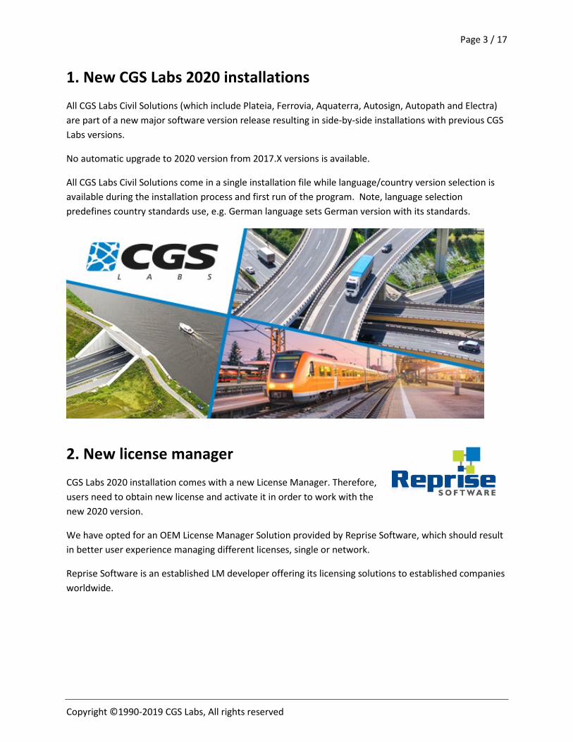
1. New CGS Labs 2020 installations All CGS Labs Civil Solutions (which include Plateia, Ferrovia, Aquaterra, Autosign, Autopath and Electra) are part of a new major software version release resulting in side-by-side installations with previous CGS Labs versions.
No automatic upgrade to 2020 version from 2017.X versions is available.
All CGS Labs Civil Solutions come in a single installation file while language/country version selection is available during the installation process and first run of the program. Note, language selection predefines country standards use, e.g. German language sets German version with its standards.
2. New license manager CGS Labs 2020 installation comes with a new License Manager. Therefore, users need to obtain new license and activate it in order to work with the new 2020 version.
We have opted for an OEM License Manager Solution provided by Reprise Software, which should result in better user experience managing different licenses, single or network.
Reprise Software is an established LM developer offering its licensing solutions to established companies worldwide.
Page 4 / 17
Copyright ©1990-2019 CGS Labs, All rights reserved
3. CAD platforms support: New CGS Labs 2020 installation supports latest Autodesk CAD platforms:
• AutoCAD/Civil 3D 2020
Support for other CAD versions continues to be available:
• AutoCAD/Civil 3D 2019-2013 • BricsCAD v19 and v17
CGS Labs strives to deliver same or similar functionality on a range or CAD platforms from older version of AutoCAD/Civil 3D as well as similar functionality on BricsCAD platforms. Slight alterations in functionality or unsupported functionality could result due to CAD platform differences, API changes between versions or unavailable compared functionality between ACAD and BCAD platforms.
4. CGS Labs 2020 backward compatibility CGS Labs 2020 solutions are fully compatible with CGS Labs older versions resulting in uninterrupted work with older DWG files or projects made years ago. Thus, saving time and interfaces needed to port projects to latest version. CGS Labs versions from 2013 to 2020 should all provide high level of compatibility.
In addition, road, railway, river canal and other projects made with latest CGS Labs 2020 version on ACAD 2020 or BCAD v19 platforms can fully worked on with CGS Labs 2020 version on any older ACAD platform down to 2013 version or BCAD versions v18 and v17.
5. User interface improvements CGS Labs Civil Solutions get important BIM enhancements presented in detail in a dedicated section bellow. New commands are now available in BIM/Utility ribbon tabs across all CGS Labs software solutions.
Autopath and Autosign got a new ribbon look in 2020 version, which will span over all CGS Labs solutions shortly. Both solutions also got new product packages, Professional and Ultimate.
Aquaterra 2020 now sports full BIM capabilities as the rest of CGS Labs solutions. Projection points and line projection form part of Layout/Profile Views and Cross-Section Views sets of commands with additional 3D solid projection option added and full Cross-Section Macros design & editing capabilities. Geospatial and BIM features form part of Aquaterra utility Tab.
Page 5 / 17
Copyright ©1990-2019 CGS Labs, All rights reserved
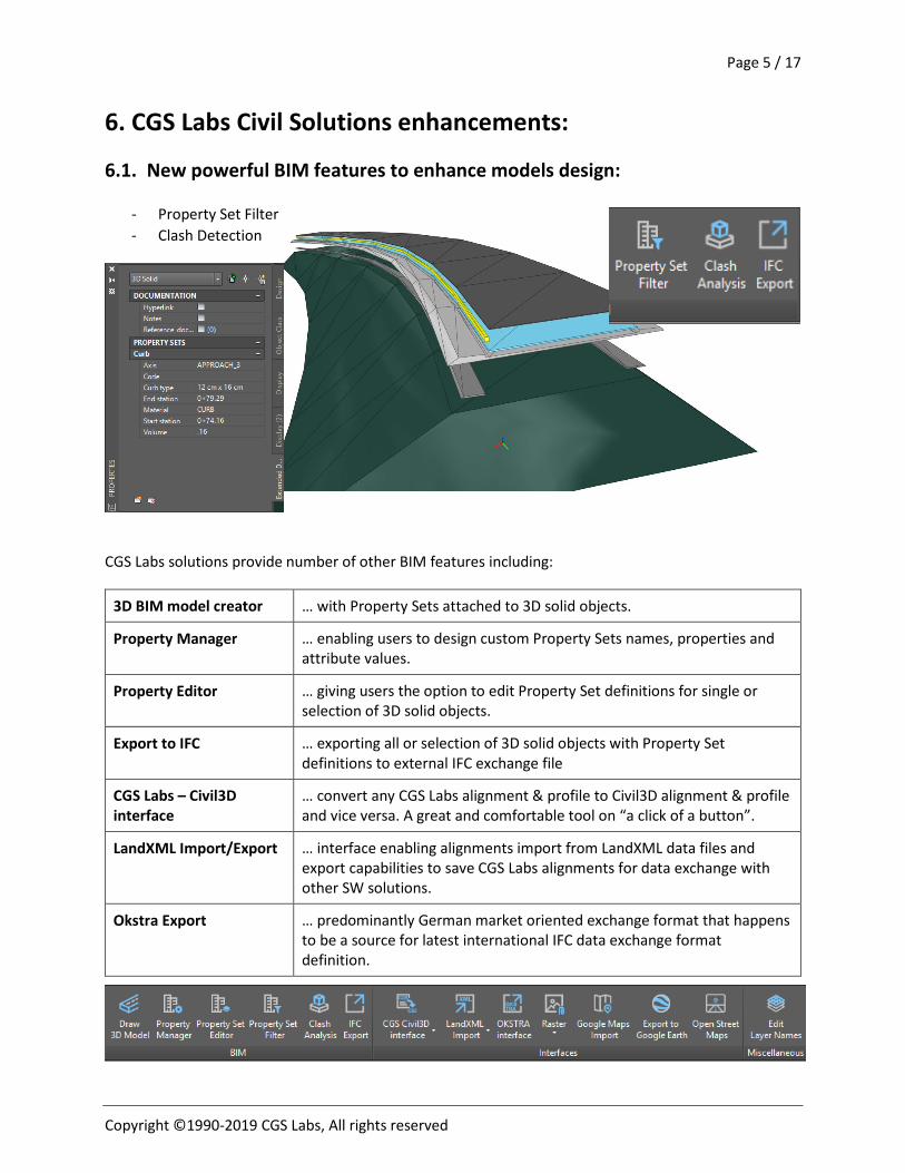
6. CGS Labs Civil Solutions enhancements:
6.1. New powerful BIM features to enhance models design:
- Property Set Filter - Clash Detection
CGS Labs solutions provide number of other BIM features including:
3D BIM model creator … with Property Sets attached to 3D solid objects.
Property Manager … enabling users to design custom Property Sets names, properties and attribute values.
Property Editor … giving users the option to edit Property Set definitions for single or selection of 3D solid objects.
Export to IFC … exporting all or selection of 3D solid objects with Property Set definitions to external IFC exchange file
CGS Labs – Civil3D interface
… convert any CGS Labs alignment & profile to Civil3D alignment & profile and vice versa. A great and comfortable tool on “a click of a button”.
LandXML Import/Export … interface enabling alignments import from LandXML data files and export capabilities to save CGS Labs alignments for data exchange with other SW solutions.
Okstra Export … predominantly German market oriented exchange format that happens to be a source for latest international IFC data exchange format definition.
Page 6 / 17
Copyright ©1990-2019 CGS Labs, All rights reserved
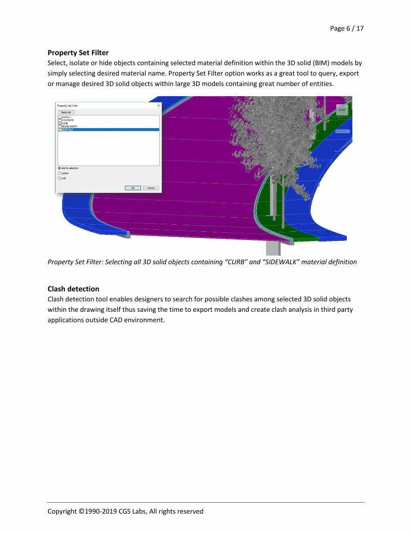
Property Set Filter Select, isolate or hide objects containing selected material definition within the 3D solid (BIM) models by simply selecting desired material name. Property Set Filter option works as a great tool to query, export or manage desired 3D solid objects within large 3D models containing great number of entities.
Property Set Filter: Selecting all 3D solid objects containing “CURB” and “SIDEWALK” material definition
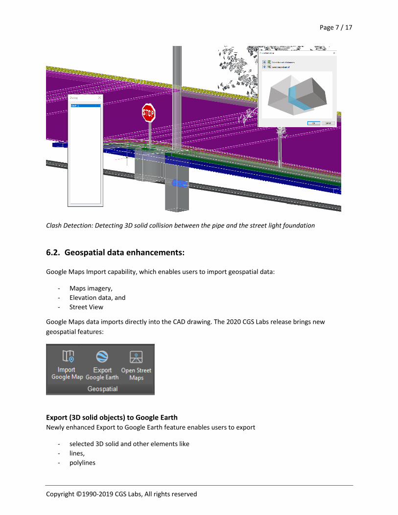
Clash detection Clash detection tool enables designers to search for possible clashes among selected 3D solid objects within the drawing itself thus saving the time to export models and create clash analysis in third party applications outside CAD environment.
Page 7 / 17
Copyright ©1990-2019 CGS Labs, All rights reserved
Clash Detection: Detecting 3D solid collision between the pipe and the street light foundation
6.2. Geospatial data enhancements:
Google Maps Import capability, which enables users to import geospatial data:
- Maps imagery, - Elevation data, and - Street View
Google Maps data imports directly into the CAD drawing. The 2020 CGS Labs release brings new geospatial features:
Export (3D solid objects) to Google Earth Newly enhanced Export to Google Earth feature enables users to export
- selected 3D solid and other elements like - lines, - polylines
Page 8 / 17
Copyright ©1990-2019 CGS Labs, All rights reserved
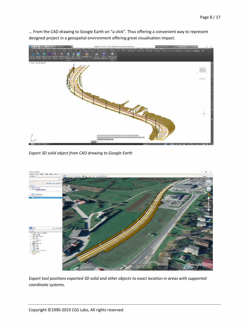
… From the CAD drawing to Google Earth on “a click”. Thus offering a convenient way to represent designed project in a geospatial environment offering great visualisation impact.
Export 3D solid object from CAD drawing to Google Earth
Export tool positions exported 3D solid and other objects to exact location in areas with supported coordinate systems.
Page 9 / 17
Copyright ©1990-2019 CGS Labs, All rights reserved
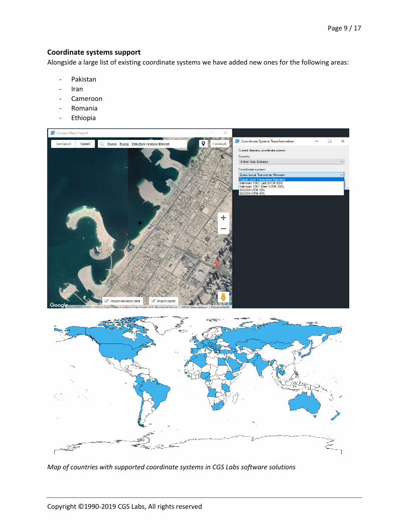
Coordinate systems support Alongside a large list of existing coordinate systems we have added new ones for the following areas:
- Pakistan - Iran - Cameroon - Romania - Ethiopia
Map of countries with supported coordinate systems in CGS Labs software solutions
Page 10 / 17
Copyright ©1990-2019 CGS Labs, All rights reserved
6.3. DESIGN ENHANCEMENETS
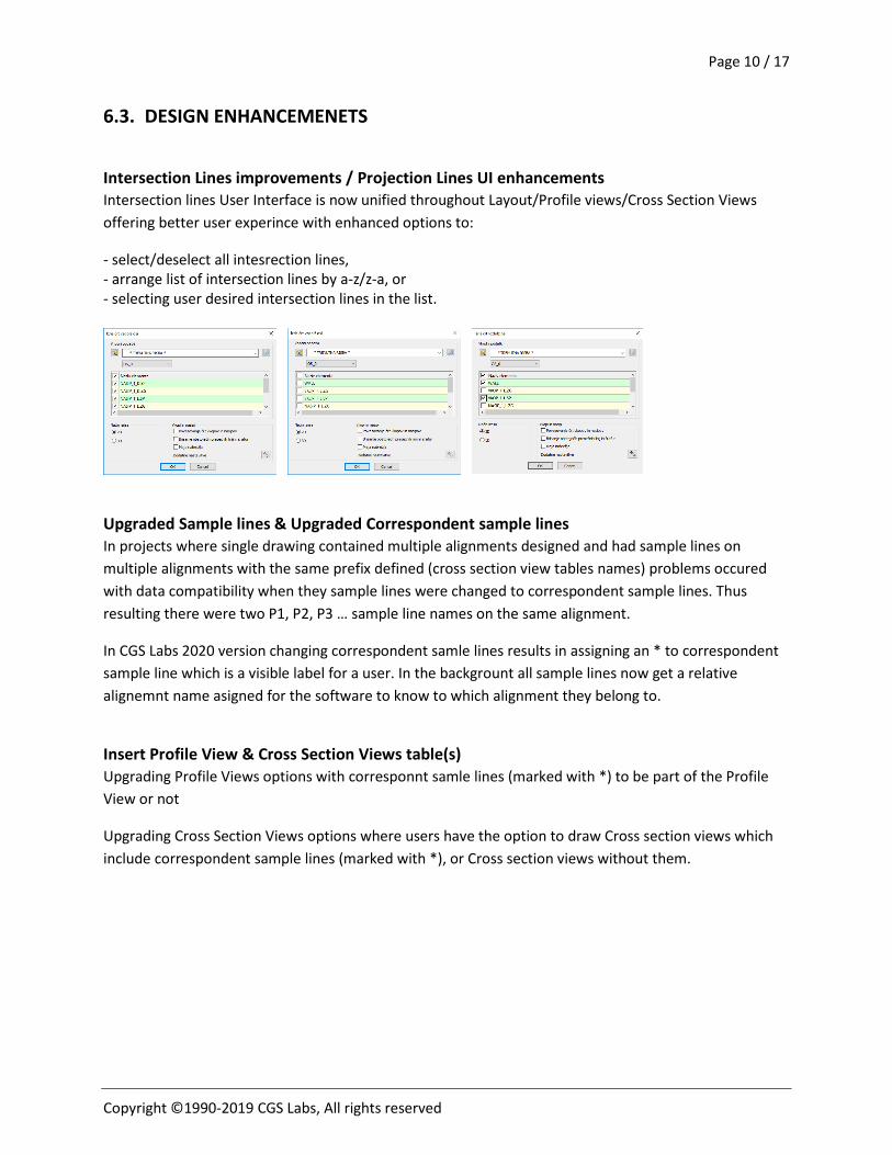
Intersection Lines improvements / Projection Lines UI enhancements Intersection lines User Interface is now unified throughout Layout/Profile views/Cross Section Views offering better user experince with enhanced options to:
- select/deselect all intesrection lines, - arrange list of intersection lines by a-z/z-a, or - selecting user desired intersection lines in the list.
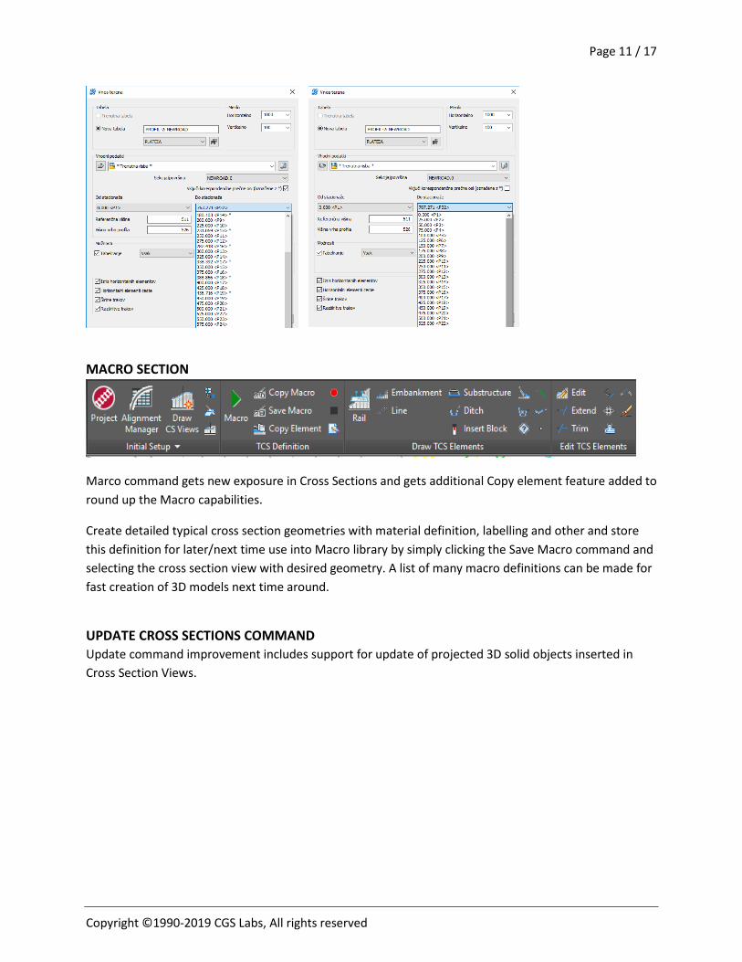
Upgraded Sample lines & Upgraded Correspondent sample lines In projects where single drawing contained multiple alignments designed and had sample lines on multiple alignments with the same prefix defined (cross section view tables names) problems occured with data compatibility when they sample lines were changed to correspondent sample lines. Thus resulting there were two P1, P2, P3 … sample line names on the same alignment.
In CGS Labs 2020 version changing correspondent samle lines results in assigning an * to correspondent sample line which is a visible label for a user. In the backgrount all sample lines now get a relative alignemnt name asigned for the software to know to which alignment they belong to.
Insert Profile View & Cross Section Views table(s) Upgrading Profile Views options with corresponnt samle lines (marked with *) to be part of the Profile View or not
Upgrading Cross Section Views options where users have the option to draw Cross section views which include correspondent sample lines (marked with *), or Cross section views without them.
Page 11 / 17
Copyright ©1990-2019 CGS Labs, All rights reserved
MACRO SECTION
Marco command gets new exposure in Cross Sections and gets additional Copy element feature added to round up the Macro capabilities.
Create detailed typical cross section geometries with material definition, labelling and other and store this definition for later/next time use into Macro library by simply clicking the Save Macro command and selecting the cross section view with desired geometry. A list of many macro definitions can be made for fast creation of 3D models next time around.
UPDATE CROSS SECTIONS COMMAND Update command improvement includes support for update of projected 3D solid objects inserted in Cross Section Views.
Page 12 / 17
Copyright ©1990-2019 CGS Labs, All rights reserved
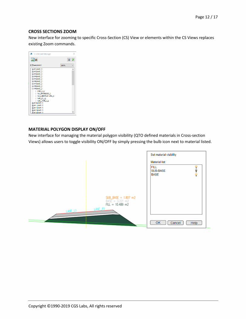
CROSS SECTIONS ZOOM New interface for zooming to specific Cross-Section (CS) View or elements within the CS Views replaces existing Zoom commands.
MATERIAL POLYGON DISPLAY ON/OFF New interface for managing the material polygon visibility (QTO defined materials in Cross-section Views) allows users to toggle visibility ON/OFF by simply pressing the bulb icon next to material listed.
Page 13 / 17
Copyright ©1990-2019 CGS Labs, All rights reserved
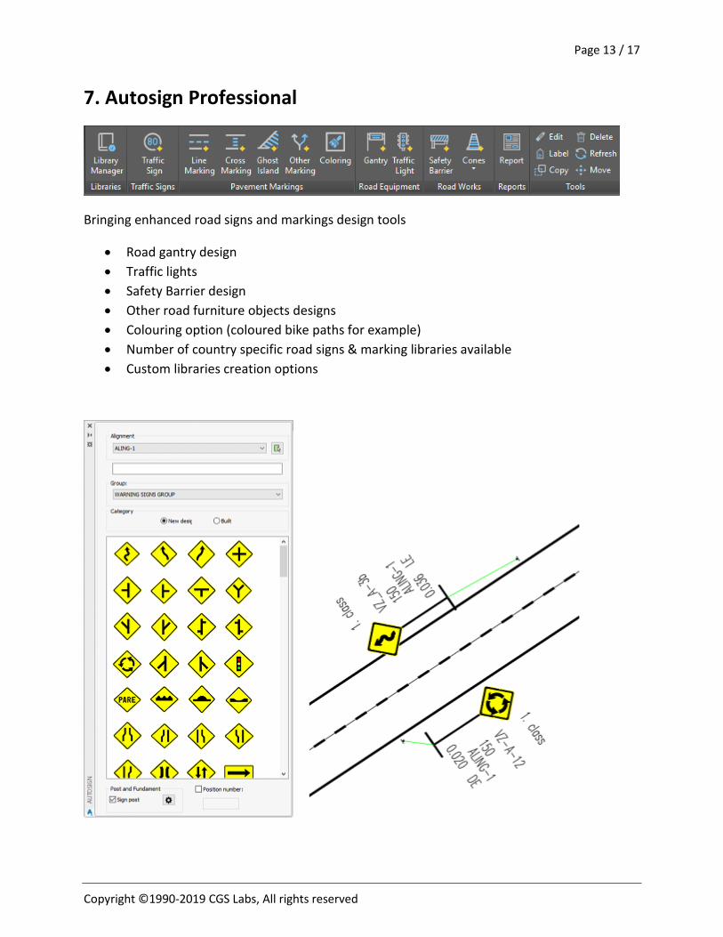
7. Autosign Professional
Bringing enhanced road signs and markings design tools
• Road gantry design • Traffic lights • Safety Barrier design • Other road furniture objects designs • Colouring option (coloured bike paths for example) • Number of country specific road signs & marking libraries available • Custom libraries creation options
Page 14 / 17
Copyright ©1990-2019 CGS Labs, All rights reserved
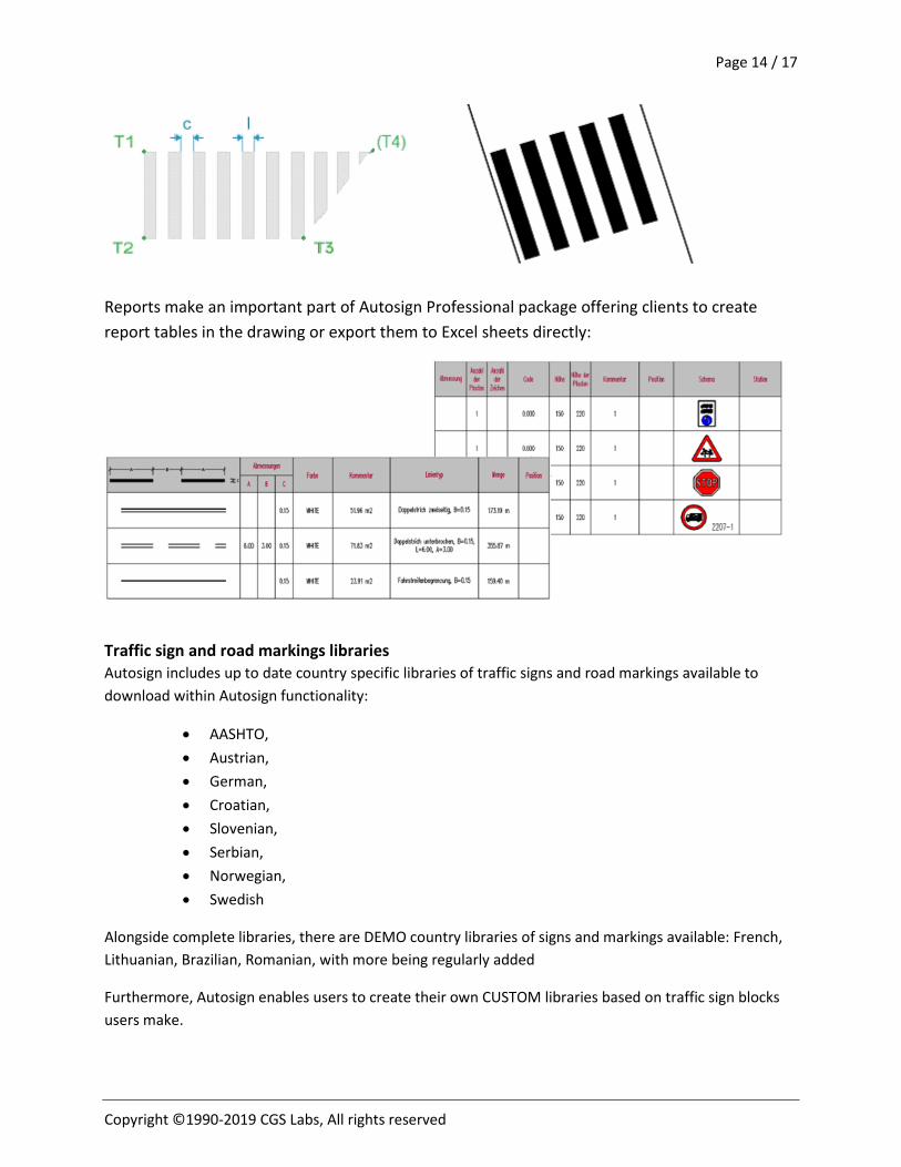
Reports make an important part of Autosign Professional package offering clients to create report tables in the drawing or export them to Excel sheets directly:
Traffic sign and road markings libraries Autosign includes up to date country specific libraries of traffic signs and road markings available to download within Autosign functionality:
• AASHTO, • Austrian, • German, • Croatian, • Slovenian, • Serbian, • Norwegian, • Swedish
Alongside complete libraries, there are DEMO country libraries of signs and markings available: French, Lithuanian, Brazilian, Romanian, with more being regularly added
Furthermore, Autosign enables users to create their own CUSTOM libraries based on traffic sign blocks users make.
Page 15 / 17
Copyright ©1990-2019 CGS Labs, All rights reserved
Autosign for Plateia users Autosign forms part of Plateia Professional and Ultimate packages and brings traffic design and management functionality providing objects like:
• Traffic signs • Road markings • Gantries • Colouring options • Cones, bollards and safety barriers • Reports • 3D representation & visualization of elements
Objects placement supports linkage to Plateia alignments with automatic stationing assigned, user comment added, custom labels and more. Autosign functionality depends on Plateia package. Plateia Professional includes Autosing Professional and Plateia Ultimate includes Autosign Ultimate functionality.
Autosign for Civil 3D users Autosign is fully compatible with AutoCAD Civil 3D. Supporting the Civil 3D surface, alignments and feature lines the placement of signs and road markings as well as other traffic design objects is seamless.
Stationing information is automatically assigned to signs, gantries etc. in relation to alignment they belong. Representing signs, markings in 3D mode by projecting to any selected Civil 3D surface is also supported.
Furthermore 3D Autosign objects data exchange between Civil 3D, Navisworks and InfraWorks solutions is fully supported.
Page 16 / 17
Copyright ©1990-2019 CGS Labs, All rights reserved
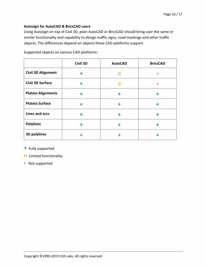
Autosign for AutoCAD & BricsCAD users Using Autosign on top of Civil 3D, plain AutoCAD or BricsCAD should bring user the same or similar functionality and capability to design traffic signs, road markings and other traffic objects. The differences depend on objects these CAD platforms support.
Supported objects on various CAD platforms:
Civil 3D AutoCAD BricsCAD
Civil 3D Alignment + o - Civil 3D Surface + o - Plateia Alignments + + + Plateia Surface + + + Lines and arcs + + + Polylines + + + 3D polylines + + +
+ Fully supported
o Limited functionality
- Not supported
Page 17 / 17
Copyright ©1990-2019 CGS Labs, All rights reserved
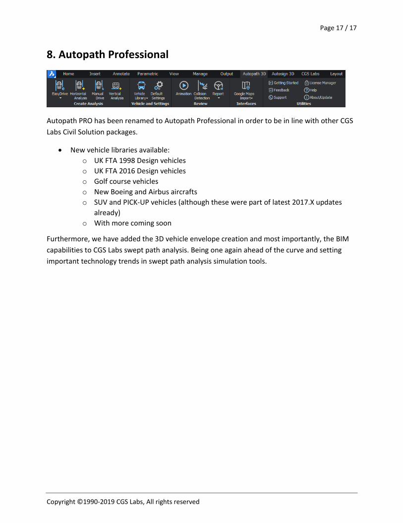
8. Autopath Professional
Autopath PRO has been renamed to Autopath Professional in order to be in line with other CGS Labs Civil Solution packages.
• New vehicle libraries available: o UK FTA 1998 Design vehicles o UK FTA 2016 Design vehicles o Golf course vehicles o New Boeing and Airbus aircrafts o SUV and PICK-UP vehicles (although these were part of latest 2017.X updates
already) o With more coming soon
Furthermore, we have added the 3D vehicle envelope creation and most importantly, the BIM capabilities to CGS Labs swept path analysis. Being one again ahead of the curve and setting important technology trends in swept path analysis simulation tools.