Embed Size (px)
Citation preview
Biodiversity assessment and offset investigation, Lightwood Park Road, Smythesdale, Victoria
Date: 21 December 2016
Author: Dr Andrew Warnock
Ref: 7262, 8868
1 Introduction
Ecology and Heritage Partners Pty Ltd was commissioned by Daniel Prior to conduct a biodiversity
assessment and offset investigation at Lots 10 and 11 of plan of subdivision 1A\PP2351, Lightwood Park
Road, Smythesdale, Victoria.
The purpose of this report is to identify the ecological values known to, or likely to occur within the study
area, assess the native vegetation proposed to be removed based on a preliminary development plan, and to
provide information on the implications of Victoria’s ‘Permitted clearing of native vegetation – Biodiversity
assessment guidelines’ (the Guidelines) (DEPI 2013).
A residential development consisting of 10 residential lots was initially proposed within the study area;
however, following further analysis, in order to minimise vegetation removals, the development plan has
been revised to comprise a new layout containing nine lots. In order to offset vegetation losses associated
with the development, vegetation within the study area is proposed to be protected and managed to
generate native vegetation credits.
The following sections describe our assessment methodology and provide information on the potential
regulatory and legislative implications associated with the proposed action.
2 Study Area
The study area is located at Lots 10 and 11 of plan of subdivision 1A\PP2351, Lightwood Park Road,
Smythesdale, Victoria, approximately 18 kilometres south-west of Ballarat (Figure 1). The site covers
approximately 43 hectares and is bound by Miners Hut Road and private property to the north, the un-used
road reserve of Lightwood Park Road to the west and private property to the south and east.
According to the Victorian Department of Environment, Land, Water and Planning (DELWP) Biodiversity
Interactive Map (DELWP 2015a), the study area occurs within the Central Victorian Uplands bioregion. It is
located within the jurisdiction of the Corangamite Catchment Management Authority (CMA) and the Golden
Plains Shire Council municipality.
3 Methods
3.1 Desktop Assessment
Relevant literature, online-resources and numerous databases were reviewed to provide an assessment of
flora and fauna values associated with the study area. The following information sources were reviewed:
2
The DELWP Biodiversity Interactive Map (DELWP 2015a) for the extent of historic and current EVCs;
The Native Vegetation Information Management (NVIM) Tool (DELWP 2015c) for modelled
biodiversity data;
The VBA (DEPI 2014), Flora Information System (FIS) (Viridans 2013a) and Atlas of Victorian Wildlife
(AVW) (Viridans 2013b) for previously documented flora and fauna records within the project
locality;
The Federal Department of Environment (DoE) Protected Matters Search Tool (PMST) for matters of
National Environmental Significance (NES) protected under the Environment Protection and
Biodiversity Conservation Act 1999 (EPBC Act) (DoE 2015);
The DELWP Planning Maps Online to ascertain current zoning and environmental overlays (DELWP
2015d);
Aerial photography of the study area;
Relevant environmental legislation and policies; and,
Previous ecological assessments within the study area.
3.2 Site Inspection
An ecological assessment of the study area was undertaken by a qualified ecologist on 16 September 2015.
The inspections sought primarily to provide ground-truthing of information provided by the desktop
assessment, particularly in relation to the following:
Modelled data for remnant vegetation patches, scattered trees and habitat for rare or threatened
species; and,
Potential habitat for species and ecological communities listed under the EPBC Act and Flora and
Fauna Guarantee Act 1988 (FFG Act).
3.3 Permitted Clearing Assessment (the Guidelines)
The clearing of native vegetation is assessed under the ‘Permitted clearing of native vegetation - Biodiversity
assessment guidelines’ (the Guidelines) (DEPI 2013). The Guidelines manage the impacts on biodiversity
from native vegetation removal using a risk-based approach. Two factors – extent risk and location risk – are
used to determine the risk associated with an application for a permit to remove native vegetation. The
location risk (A, B or C) has been determined for all areas in Victoria and is available on DELWP’s Native
Vegetation Information Management (NVIM) Tool (DELWP 2015c). Determination of risk-based pathway is
summarised in Table 1.
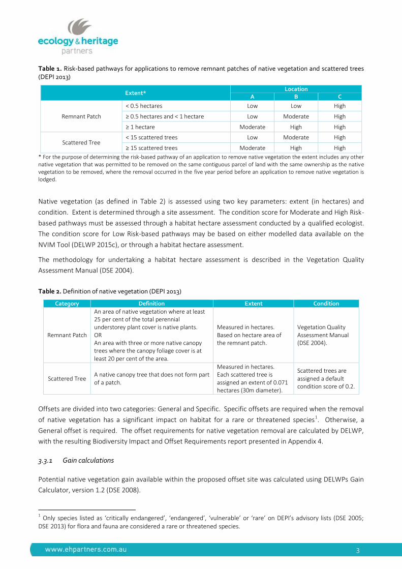
3
Table 1. Risk-based pathways for applications to remove remnant patches of native vegetation and scattered trees (DEPI 2013)
Extent* Location
A B C
Remnant Patch
< 0.5 hectares Low Low High
≥ 0.5 hectares and < 1 hectare Low Moderate High
≥ 1 hectare Moderate High High
Scattered Tree < 15 scattered trees Low Moderate High
≥ 15 scattered trees Moderate High High
* For the purpose of determining the risk-based pathway of an application to remove native vegetation the extent includes any other native vegetation that was permitted to be removed on the same contiguous parcel of land with the same ownership as the native vegetation to be removed, where the removal occurred in the five year period before an application to remove native vegetation is lodged.
Native vegetation (as defined in Table 2) is assessed using two key parameters: extent (in hectares) and
condition. Extent is determined through a site assessment. The condition score for Moderate and High Risk-
based pathways must be assessed through a habitat hectare assessment conducted by a qualified ecologist.
The condition score for Low Risk-based pathways may be based on either modelled data available on the
NVIM Tool (DELWP 2015c), or through a habitat hectare assessment.
The methodology for undertaking a habitat hectare assessment is described in the Vegetation Quality
Assessment Manual (DSE 2004).
Table 2. Definition of native vegetation (DEPI 2013)
Category Definition Extent Condition
Remnant Patch
An area of native vegetation where at least 25 per cent of the total perennial understorey plant cover is native plants. OR An area with three or more native canopy trees where the canopy foliage cover is at least 20 per cent of the area.
Measured in hectares. Based on hectare area of the remnant patch.
Vegetation Quality Assessment Manual (DSE 2004).
Scattered Tree A native canopy tree that does not form part of a patch.
Measured in hectares. Each scattered tree is assigned an extent of 0.071 hectares (30m diameter).
Scattered trees are assigned a default condition score of 0.2.
Offsets are divided into two categories: General and Specific. Specific offsets are required when the removal
of native vegetation has a significant impact on habitat for a rare or threatened species1. Otherwise, a
General offset is required. The offset requirements for native vegetation removal are calculated by DELWP,
with the resulting Biodiversity Impact and Offset Requirements report presented in Appendix 4.
3.3.1 Gain calculations
Potential native vegetation gain available within the proposed offset site was calculated using DELWPs Gain
Calculator, version 1.2 (DSE 2008).
1 Only species listed as ‘critically endangered’, ‘endangered’, ‘vulnerable’ or ‘rare’ on DEPI’s advisory lists (DSE 2005;
DSE 2013) for flora and fauna are considered a rare or threatened species.
4
3.4 Limitations
The short duration of the survey meant that migratory, transitory or uncommon fauna species may have
been absent from typically occupied habitats at the time of the field assessment. In addition, annual or
cryptic flora species such as those that persist via underground tubers may also be absent. Targeted flora or
fauna surveys were not undertaken, as this was beyond the preliminary scope. Nevertheless, the terrestrial
flora and fauna data collected during the field assessment and information obtained from relevant desktop
sources is considered adequate to provide an accurate and indicative assessment of the ecological values
present within the study area.
4 Results
4.1 Vegetation
4.1.1 Forest
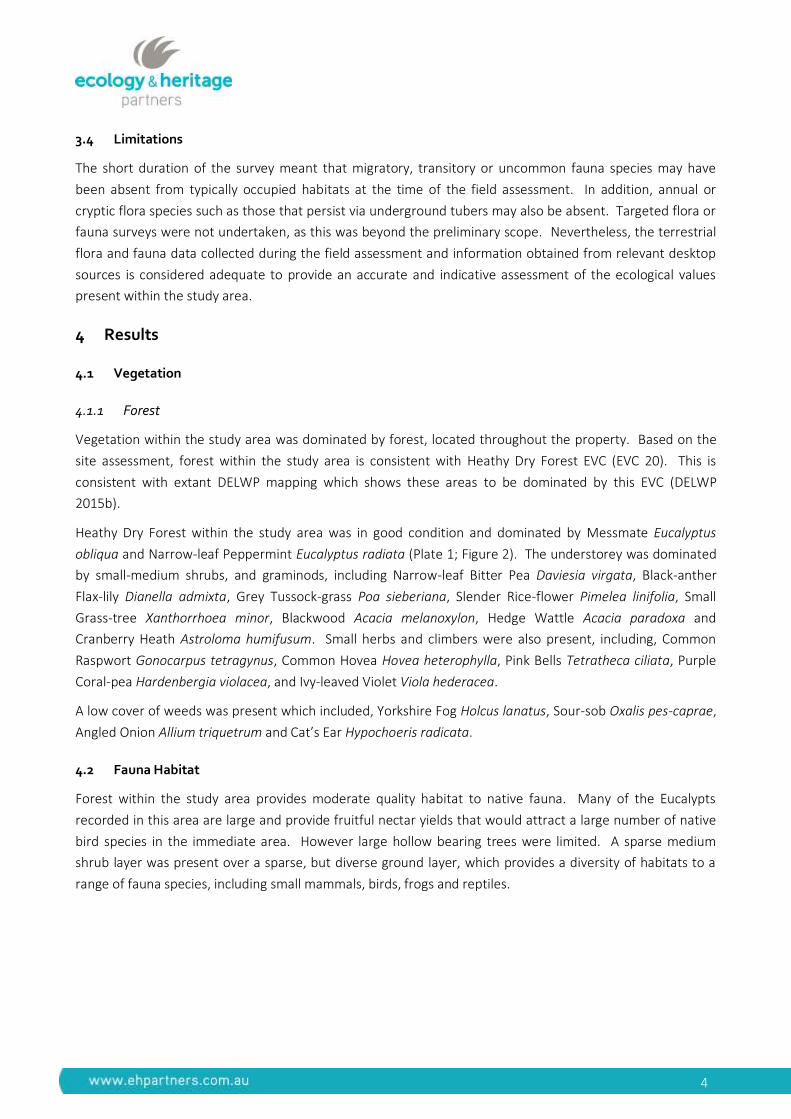
Vegetation within the study area was dominated by forest, located throughout the property. Based on the
site assessment, forest within the study area is consistent with Heathy Dry Forest EVC (EVC 20). This is
consistent with extant DELWP mapping which shows these areas to be dominated by this EVC (DELWP
2015b).
Heathy Dry Forest within the study area was in good condition and dominated by Messmate Eucalyptus
obliqua and Narrow-leaf Peppermint Eucalyptus radiata (Plate 1; Figure 2). The understorey was dominated
by small-medium shrubs, and graminods, including Narrow-leaf Bitter Pea Daviesia virgata, Black-anther
Flax-lily Dianella admixta, Grey Tussock-grass Poa sieberiana, Slender Rice-flower Pimelea linifolia, Small
Grass-tree Xanthorrhoea minor, Blackwood Acacia melanoxylon, Hedge Wattle Acacia paradoxa and
Cranberry Heath Astroloma humifusum. Small herbs and climbers were also present, including, Common
Raspwort Gonocarpus tetragynus, Common Hovea Hovea heterophylla, Pink Bells Tetratheca ciliata, Purple
Coral-pea Hardenbergia violacea, and Ivy-leaved Violet Viola hederacea.
A low cover of weeds was present which included, Yorkshire Fog Holcus lanatus, Sour-sob Oxalis pes-caprae,
Angled Onion Allium triquetrum and Cat’s Ear Hypochoeris radicata.
4.2 Fauna Habitat
Forest within the study area provides moderate quality habitat to native fauna. Many of the Eucalypts
recorded in this area are large and provide fruitful nectar yields that would attract a large number of native
bird species in the immediate area. However large hollow bearing trees were limited. A sparse medium
shrub layer was present over a sparse, but diverse ground layer, which provides a diversity of habitats to a
range of fauna species, including small mammals, birds, frogs and reptiles.
5
Plate 1. Heathy Dry Forest within the study area, (Source EHP 16/09/2015).
4.3 Significant Flora and Fauna
4.3.1 Flora
The VBA and FIS contain records of three nationally significant and 12 State significant flora species
previously recorded within 10 kilometres of the study area (DEPI 2014; Viridans 2013a) (Appendix 1; Figure
3). The PMST nominated an additional ten nationally significant species which have not been recorded in the
locality but have the potential to occur (DoE 2015).
While not recorded during the site assessment, there is a moderate likelihood that the study area supports
the State significant Yarra Gum Eucalyptus yarraensis.
4.3.2 Fauna
The VBA and FIS contain records of two nationally significant, 24 State significant and seven regionally
significant fauna species previously recorded within 10 kilometres of the study area (DEPI 2014; Viridans
2013a) (Appendix 2; Figure 3). The PMST nominated an additional 11 nationally significant species which
have not been recorded in the locality but have the potential to occur (DoE 2015).
While not recorded during the site assessment, there is a moderate likelihood that the study area supports
the State significant Brush-tailed Phascogale Phascogale tapoatafa, Powerful Owl Ninox strenua, Brown
Treecreeper (south-eastern ssp.) Climacteris picumnus victoriae, Brown Toadlet Pseudophryne bibronii and
Southern Toadlet Pseudophryne semimarmorata.
4.4 Permitted Clearing Assessment (the Guidelines)
Based on DELWP’s NVIM Tool, the study area is within Location A, with 10.514 hectares of native vegetation
assumed to be impacted2. As such, the permit application falls under the Moderate Risk-based pathway.
2 Vegetation assumed to be impacted includes all vegetation within road reserves of new roads to be constructed, two metre buffer either side of new parcel boundaries, proposed dwelling footprints, and defendable space (Figure 2). All areas of defendable space were treated as 100% loss of vegetation quality, in accordance with DELWP (2015e), given partial clearing of understorey species and partial removal of canopy trees is required in accordance with the Bushfire Management Statement (Ecology and Heritage Partners 2016).
6
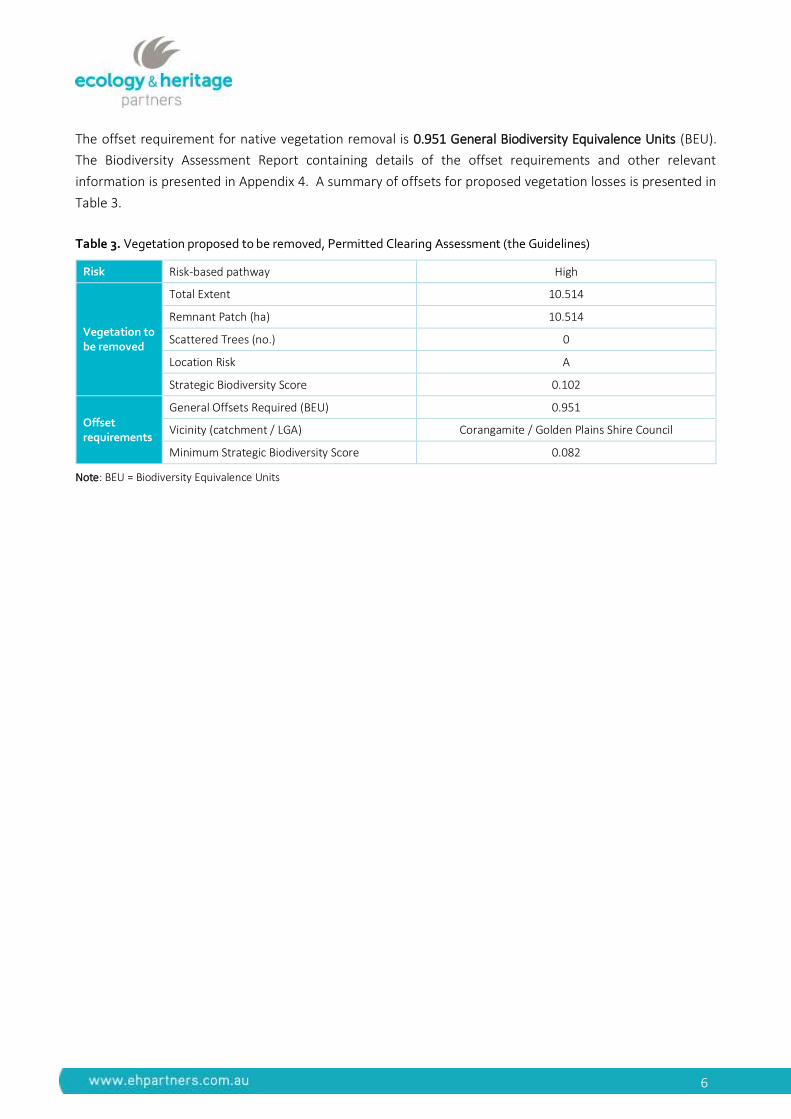
The offset requirement for native vegetation removal is 0.951 General Biodiversity Equivalence Units (BEU).
The Biodiversity Assessment Report containing details of the offset requirements and other relevant
information is presented in Appendix 4. A summary of offsets for proposed vegetation losses is presented in
Table 3.
Table 3. Vegetation proposed to be removed, Permitted Clearing Assessment (the Guidelines)
Risk Risk-based pathway High
Vegetation to be removed
Total Extent 10.514
Remnant Patch (ha) 10.514
Scattered Trees (no.) 0
Location Risk A
Strategic Biodiversity Score 0.102
Offset requirements
General Offsets Required (BEU) 0.951
Vicinity (catchment / LGA) Corangamite / Golden Plains Shire Council
Minimum Strategic Biodiversity Score 0.082
Note: BEU = Biodiversity Equivalence Units
7
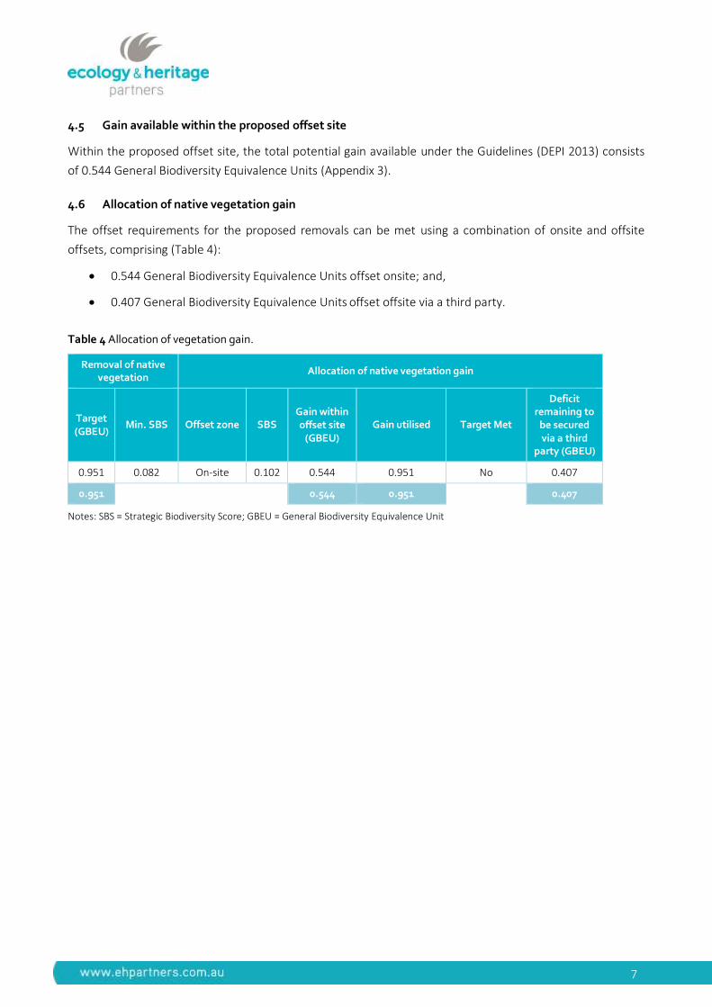
4.5 Gain available within the proposed offset site
Within the proposed offset site, the total potential gain available under the Guidelines (DEPI 2013) consists
of 0.544 General Biodiversity Equivalence Units (Appendix 3).
4.6 Allocation of native vegetation gain
The offset requirements for the proposed removals can be met using a combination of onsite and offsite
offsets, comprising (Table 4):
0.544 General Biodiversity Equivalence Units offset onsite; and,
0.407 General Biodiversity Equivalence Units offset offsite via a third party.
Table 4 Allocation of vegetation gain.
Removal of native vegetation
Allocation of native vegetation gain
Target (GBEU)
Min. SBS Offset zone SBS Gain within offset site
(GBEU) Gain utilised Target Met
Deficit remaining to
be secured via a third
party (GBEU)
0.951 0.082 On-site 0.102 0.544 0.951 No 0.407
0.951
0.544 0.951 0.317 0.407
Notes: SBS = Strategic Biodiversity Score; GBEU = General Biodiversity Equivalence Unit

5 Legislative and Policy Implications
5.1 Environment Protection and Biodiversity Conservation Act 1999
The Environment Protection and Biodiversity Conservation Act 1999 (EPBC Act) establishes a Commonwealth
process for the assessment of proposed actions (i.e. project, development, undertaking, activity, or series of
activities) likely to have a significant impact on matters of National Environment Significance (NES), or those
that are undertaken on Commonwealth Land.
No matters of National Environmental Significance are likely to occur within the study area, or are likely to be
impacted by the proposed development (Appendix 1)
5.2 Flora and Fauna Guarantee Act 1988
The FFG Act is the primary legislation dealing with biodiversity conservation and sustainable use of native
flora and fauna in Victoria. Proponents are required to apply for an FFG Act Permit to ‘take’ listed and/or
protected3 flora species, listed vegetation communities and listed fish species in areas of public land (i.e.
within road reserves, drainage lines and public reserves). An FFG Act permit is generally not required for
removal of species or communities on private land, or for the removal of habitat for a listed terrestrial fauna
species.
Two species protected under the FFG Act were recorded within the study area, Small Grass-tree and
Cranberry Heath. There is suitable habitat within the study area for additional species protected under the
FFG Act (e.g. daisies and wattles). A permit under the FFG Act will be required for removal of listed species
within areas of public land (road reserves, including currently un-used road reserves). The proponent should
allow up to six weeks to obtain an FFG Act permit through DELWP.
5.3 Planning and Environment Act 1987
The Planning and Environment Act 1987 outlines the legislative framework for planning in Victoria and for
the development and administration of planning schemes. All planning schemes contain native vegetation
provisions at Clause 52.17, which require a planning permit from the relevant local Council to remove,
destroy or lop native vegetation on a site of more than 0.4 hectares, unless an exemption under clause
52.17-7 of the Victorian Planning Schemes applies or a subdivision is proposed with lots less than 0.4
hectares4.
3 In addition to ‘listed’ flora species, the FFG Act identifies ‘protected’ flora species. This includes any of the Asteraceae (Daisies) Ericaceae (Heaths), all orchids, ferns (excluding Pteridium esculentum), Xanthorrhoea species, Acacia species (excluding Acacia dealbata, Acacia decurrens, Acacia implexa, Acacia melanoxylon and Acacia paradoxa), as well as any taxa that may be a component of a listed ecological community. A species may be both listed and protected.
4 In accordance with the Victorian Civil and Administrative Tribunal’s (VCAT) decision Villawood v Greater Bendigo CC (2005) VCAT 2703 (20 December 2005) all native vegetation is considered lost where proposed lots are less than 0.4 hectares in area and must be offset at the time of subdivision.
9
5.3.1 Local Planning Schemes
The study area is located within the Golden Plains Shire Council municipality and is zoned Rural Living Zone
(RLZ). The following overlays apply:
Bushfire Management Overlay (BMO) – relating to protection of human life and infrastructure from
bushfire.; and,
Design and Development Overlay – Schedule 7 (DDO7).
A Planning Permit from Golden Plains Shire Council is required to remove, destroy or lop any native
vegetation. DELWP is likely to be a mandatory recommending referral authority as more than 0.5 hectares
of native vegetation is proposed to be removed.
A Bushfire Management Plan has been prepared, in accordance with the requirements of the Bushfire
Management Overlay (Ecology and Heritage Partners 2016.
5.3.2 Permitted clearing of native vegetation - Biodiversity assessment guidelines
The Victorian Planning Provisions relating to biodiversity protection and native vegetation management was
amended in December 2013 to reflect the new permitted clearing of native vegetation and biodiversity
policy encapsulated in the ’Permitted clearing of native vegetation - Biodiversity assessment guidelines’ (the
Guidelines) (DEPI 2013).
Areas of remnant native vegetation to be impacted must be offset, including areas of defendable space. The
results of the permitted clearing assessment under the Guidelines are presented above (Section 4.4).
5.4 Wildlife Act 1975 and Wildlife Regulations 2013 (Victoria)
The Wildlife Act 1975 (and associated Wildlife Regulations 2013) is the primary legislation in Victoria
providing for protection and management of wildlife. Authorisation for habitat removal may be obtained
under the Wildlife Act 1975 through a licence granted under the Forests Act 1958, or under any other Act
such as the Planning and Environment Act 1987. Any persons engaged to remove, salvage, hold or relocate
native fauna during construction must hold a current Management Authorisation under the Wildlife Act
1975.
5.5 Catchment and Land Protection Act 1994
The Catchment and Land Protection Act 1994 (CaLP Act) contains provisions relating to catchment planning,
land management, noxious weeds and pest animals. Landowners are responsible for the control of any
infestation of noxious weeds and pest fauna species to minimise their spread and impact on ecological
values.
Two weed listed as noxious under the CaLP Act was recorded during the assessment (Sour-sob and Angled
Onion). Similarly, there is evidence that the study area is currently occupied by several pest fauna species
listed under the CaLP Act (Red Fox Vulpes vulpes and European Rabbit Oryctolagus cuniculus). A Weed
Management Plan and a pest fauna eradication plan may be required.
10
5.6 Potential Impacts
The proposed action is likely to directly impact on several indigenous flora and fauna species, and
communities recorded within the study area. These impacts may include:
Loss of potential habitat for State (Yarra Gum);
Loss of potential habitat for State (Brush-tailed Phascogale, Powerful Owl, Brown Treecreeper
(south-eastern ssp.), Brown Toadlet and Southern Toadlet);
The removal of an EVC of Least Concern (Heathy Dry Forest);
Loss of habitat and potential mortality for locally common fauna species dependent on tree hollows
(e.g. Common Brush-tailed Possum Trichosurus vulpecula, Eastern Rosella Platycercus eximius,
Rainbow Lorikeet Trichoglossus haematodus, Gould’s Wattled Bat Chalinolobus gouldii), loose or
shedding bark (e.g. Lesser Long-eared Bat Nictophilus geoffroyi) and leaf litter and other ground
debris (e.g. lizards, snakes, frogs and invertebrates) for foraging, shelter, roosting or nesting;
Potential for the spread of weeds and soil pathogens due to on-site activities;
Disturbance to wildlife from increased human activity and noise during construction; and,
Indirect impacts on adjacent areas if construction activities and drainage are not appropriately
managed.
11
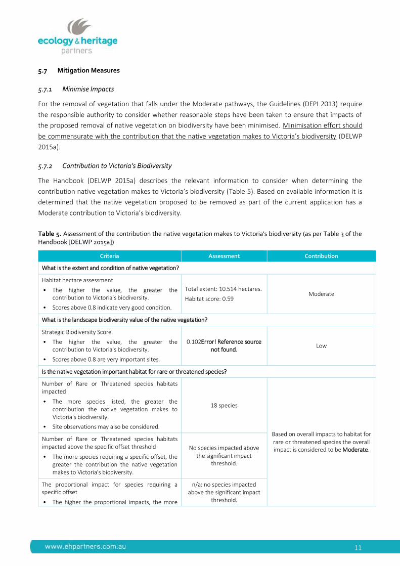
5.7 Mitigation Measures
5.7.1 Minimise Impacts
For the removal of vegetation that falls under the Moderate pathways, the Guidelines (DEPI 2013) require
the responsible authority to consider whether reasonable steps have been taken to ensure that impacts of
the proposed removal of native vegetation on biodiversity have been minimised. Minimisation effort should
be commensurate with the contribution that the native vegetation makes to Victoria’s biodiversity (DELWP
2015a).
5.7.2 Contribution to Victoria’s Biodiversity
The Handbook (DELWP 2015a) describes the relevant information to consider when determining the
contribution native vegetation makes to Victoria’s biodiversity (Table 5). Based on available information it is
determined that the native vegetation proposed to be removed as part of the current application has a
Moderate contribution to Victoria’s biodiversity.
Table 5. Assessment of the contribution the native vegetation makes to Victoria's biodiversity (as per Table 3 of the Handbook [DELWP 2015a])
Criteria Assessment Contribution
What is the extent and condition of native vegetation?
Habitat hectare assessment
• The higher the value, the greater the contribution to Victoria's biodiversity.
• Scores above 0.8 indicate very good condition.
Total extent: 10.514 hectares.
Habitat score: 0.59 Moderate
What is the landscape biodiversity value of the native vegetation?
Strategic Biodiversity Score
• The higher the value, the greater the contribution to Victoria's biodiversity.
• Scores above 0.8 are very important sites.
0.102Error! Reference source not found.
Low
Is the native vegetation important habitat for rare or threatened species?
Number of Rare or Threatened species habitats impacted
• The more species listed, the greater the contribution the native vegetation makes to Victoria's biodiversity.
• Site observations may also be considered.
18 species
Based on overall impacts to habitat for rare or threatened species the overall impact is considered to be Moderate.
Number of Rare or Threatened species habitats impacted above the specific offset threshold
• The more species requiring a specific offset, the greater the contribution the native vegetation makes to Victoria's biodiversity.
No species impacted above the significant impact
threshold.
The proportional impact for species requiring a specific offset
• The higher the proportional impacts, the more
n/a: no species impacted above the significant impact
threshold.
12
Criteria Assessment Contribution
important that site is for that particular species.
Habitat importance score for impacted species
• The higher the habitat importance score, the more important that site is for that particular species.
n/a: no species impacted above the significant impact
threshold.
Impact on highly localised habitat
• Native vegetation that provides habitat for species with highly localised habitat is very important vegetation as it is limited and any loss needs to be carefully considered.
n/a: no species impacted above the significant impact
threshold.
5.7.3 Minimisation Statement5
The following measures have been taken to minimise the impacts of the proposed removal of native
vegetation on biodiversity:
Reduction in the number of proposed residential lots from ten to nine;
Sharing of defendable space between adjacent lots where possible; and,
Dwellings located as close as possible to access roads.
5 Section 5.2 (page 20) of the Handbook (DELWP 2015a) states:
“Minimisation should target native vegetation that makes the greatest contribution to Victoria’s biodiversity - that is, areas of better condition, higher strategic biodiversity score, and/or higher habitat importance scores.
The minimisation statement could state that minimisation was achieved by a past strategic planning exercise or by site interventions, or that it is not achievable or desirable on site for specific reasons.”
Section 6.3.2 (page 26) of the Handbook (DELWP 2015a) states:
“Minimisation should be commensurate with the contribution that the native vegetation makes to Victoria’s biodiversity. Minimum effort can be considered reasonable when the native vegetation contributes lower value to Victoria’s biodiversity – for example, only general offsets are required, strategic biodiversity score is low, the native vegetation is limited in extent and isolated from other patches of remnant vegetation.”
Section 6.5, Table 4 (page 29) of the Handbook (DELWP 2015a) states:
“Statement can describe that minimisation is unreasonable at the site level because the native vegetation makes a very low contribution to biodiversity (such as no species offset requires, low strategic biodiversity score) or because retained native vegetation would have limited long term prospect of retaining biodiversity value.”
13
5.7.4 Best Practice Mitigation Measures
Recommended measures to mitigate impacts upon terrestrial and aquatic values present within the study
area may include:
Minimise impacts to native vegetation and habitats through construction and micro-siting
techniques. If indeed necessary, trees should be lopped or trimmed rather than removed.;
All contractors should be aware of ecologically sensitive areas to minimise the likelihood of
inadvertent disturbance to areas marked for retention. Native vegetation to be retained should be
included as a mapping overlay on any construction plans;
Removal of any habitat trees or shrubs (particularly hollow-bearing trees) should be undertaken
between February and September to avoid the breeding season for the majority of fauna species. If
any habitat trees or shrubs are proposed to be removed, this should be undertaken under the
supervision of an appropriately qualified zoologist to salvage and translocate any displaced fauna. A
Fauna Management Plan may be required to guide the salvage and translocation process;
Ensure that best practice sedimentation and pollution control measures are undertaken at all times,
in accordance with Environment Protection Agency guidelines (EPA 1991; EPA 1996; Victorian
Stormwater Committee 1999) to prevent offsite impacts to waterways and wetlands; and,
As indigenous flora provides valuable habitat for indigenous fauna, it is recommended that any
landscape plantings that are undertaken as part of the proposed works are conducted using
indigenous species sourced from a local provenance, rather than exotic deciduous trees and shrubs.
In addition to these measures, the following documents should be prepared and implemented prior to any
construction activities:
Construction Environmental Management Plan (CEMP). The CEMP should include specific
species/vegetation conservation strategies, daily monitoring, sedimentation management, site
specific rehabilitation plans, weed and pathogen management measures, etc.;
5.7.5 Offset Strategy
The offset requirements are proposed to be met through a combination of onsite and offsite offsets (Section
4.6).
Ecology and Heritage Partners are a DELWP accredited OTC offset broker. Ecology and Heritage Partners can
confirm that the offset obligations generated by this proposal can be satisfied through existing credits
registered in our OTC database. Several landowners registered in our offset database have suitable General
Biodiversity Equivalence Unit (BEUs) native vegetation credits available within the Corangamite CMA.
14
6 Further Requirements
Further requirements associated with development of the study area, as well as additional studies or
reporting that may be required, are provided in Table 6, below.
Table 6. Further requirements associated with development of the study area
Relevant Legislation Implications Further Action
Environment Protection and Biodiversity Conservation Act 1999
No matters of National Environmental Significance are likely to occur within the study area, or are likely to be impacted by the proposed development
No further action required.
Flora and Fauna Guarantee Act 1988
Two species protected under the FFG Act were recorded within the study area, Small Grass-tree and Cranberry Heath. There is suitable habitat within the study area for additional species protected under the FFG Act (e.g. daisies and wattles). A permit under the FFG Act will be required for removal of listed species within areas of public land (road reserves, including currently un-used road reserves). The proponent should allow up to six weeks to obtain an FFG Act permit through DELWP.
Apply for permit under the FFG Act to ‘take’ listed species within public land.
Planning and Environment Act 1987
A Planning Permit from Golden Plains Shire Council is required to remove, destroy or lop any native vegetation.
Areas of remnant native vegetation must be offset if they are proposed to be disturbed as part of the project. The results of the permitted clearing assessment under the Guidelines are presented in Section 4.4.
The property is covered by a Bushfire Management Overlay, requiring a Bushfire Management Statement to be prepared.
Prepare and submit a Planning Permit application. Planning Permit conditions are likely to include a requirement for:
Demonstration of impact minimisation.
A Bushfire Management Statement.
Catchment and Land Protection Act 1994
Weeds listed under the CaLP Act were recorded within the study area.
To meet requirements under the CaLP Act, listed noxious weeds should be appropriately controlled throughout the study area.
Wildlife Act 1975
Any persons engaged to conduct salvage and translocation or general handling of terrestrial fauna species must hold a current Management Authorisation.
Ensure wildlife specialists hold a current Management Authorisation.
15
7 References
DELWP 2015a. Biodiversity Interactive Map [WWW Document]. URL
http://mapshare2.dse.vic.gov.au/MapShare2EXT/imf.jsp?site=bim (accessed 1.4.12). Victorian
Department of Environment, Land, Water and Planning.
DELWP 2015b. Ecological Vegetation Class (EVC) Benchmarks for each Bioregion [WWW Document]. URL
http://www.dse.vic.gov.au/conservation-and-environment/native-vegetation-groups-for-
victoria/ecological-vegetation-class-evc-benchmarks-by-bioregion (accessed 1.4.12). Victorian
Department of Environment, Land, Water and Planning.
DELWP 2015c. Native Vegetation Information Management Tool [WWW Document] URL
http://nvim.depi.vic.gov.au/ Victorian Department of Environment and Primary Industries.
DELWP 2015d. Planning Maps Online [www Document]. URL
http://services.land.vic.gov.au/landchannel/jsp/map/PlanningMapsIntro.jsp (accessed 1.23.13).
DELWP 2015e. Biodiversity Assessment Handbook. Victorian Department of Environment and Primary
Industries.
DEPI 2013. Permitted clearing of native vegetation - Biodiversity assessment guidelines (the Guidelines).
Victorian Department of Environment and Primary Industries, September 2013.
DEPI 2014. Victorian Biodiversity Atlas. Sourced from: “VBA_FLORA25” and “VBA_FLORA100”, 2014.
Victorian Department of Environment and Primary Industries.
DEWHA 2009. Significant Impact Guidelines 1.1. Matters of National Environmental Significance. Federal
Department of the Environment, Water, Heritage and the Arts, Canberra.
DoE 2015. Protected Matters Search Tool: Interactive Map [WWW Document]. URL
http://www.environment.gov.au/arcgis-framework/apps/pmst/pmst.jsf (accessed 1.4.12). Federal
Department of Environment, Canberra.
DSE 2004. Vegetation quality assessment manual: Guidelines for applying the habitat hectares scoring
method. Version 1.3. Victorian Department of Sustainability and Environment.
DSE 2005. Advisory List of Rare or Threatened Plants in Victoria. Victorian Department of Sustainability and
Environment.
DSE 2008. DSE Gain Calculator, version 1.2, October 2008. Victorian Department of Sustainability and
Environment.
DSE 2009. Advisory list of Threatened Invertebrate Fauna in Victoria – 2009. Victorian Department of
Sustainability and Environment.
DSE 2013. Advisory List of Rare or Threatened Fauna in Victoria. Victorian Department of Sustainability and
Environment.
Ecology and Heritage Partners 2016. Lightwood Park Road, Smythesdale, Victoria: Bushfire Management
Statement. Unpublished report for Dan Prior.
16
Viridans 2013a. Flora Information System. Viridans Biological Databases.
Viridans 2013b. Victorian Fauna Database. Viridans Biological Databases.

Smythesdale
Woa
dyYa
loak R
iver
Brooke St
Ballarat - Carngham Rd
Glenelg
Hwy
Sebastopol - Smythesdale Rd
Haddon School Rd
Smythesdale - Snake Valley Rd
Haddon - Preston Hill Rd
Andre
w Dr
Hope
s Lan
e
Wilso
ns R
d
Woady YallockRiver, SmythesdaleStreamside Reserve
SmythesdaleH16 Bushland
Reserve
SmythesdaleH15 Bushland
Reserve
SurfaceHill Historic
Reserve
NintingboolBushlandReserve
SmythesdaleCourt complex
Historic Reserve
HADDON
SNAKEVALLEY
HILLCREST
BO PEEP
NINTINGBOOL
CARNGHAM
SMYTHESDALE
SCARSDALE7262_Fig01_StudyArea 14/10/2015 melsley
¹ 0 1,000500
Metres
Figure 1Location of the study areaLightwood Park Rd,Smythesdale
VicMap Data: The State of Victoria does not warrant theaccuracy or completeness of information in this publicationand any person using or relying upon such information doesso on the basis that the State of Victoria shall bear noresponsibility or liability whatsoever for any errors, faults,defects or omissions in the information.
_̂
!(
Haddon
MelbourneGolden
Plains (S)
LegendStudy area
Major RoadCollector RoadMinor RoadWalking TrackMinor WatercoursePermanent WaterbodyLand Subject to InundationParks and ReservesCrown Land
!
! ! !
!! Localities
"S
"S
"S
Miners Hut Rd
8868_Fig02_EcoFeat_from fr8248 14/12/2016 melsley
¹ 0 10050
Metres
Figure 2Ecological featuresMiners Hut Road, Carngham
VicMap Data: The State of Victoria does not warrant theaccuracy or completeness of information in this publicationand any person using or relying upon such information doesso on the basis that the State of Victoria shall bear noresponsibility or liability whatsoever for any errors, faults,defects or omissions in the information.
_̂
!(
Haddon
MelbourneGolden
Plains (S)
LegendMiners Hut Road, CarnghamHeathy Dry ForestVegetation impactedProposed offset areaDwelling10m bufferDefendable space (35m and43m)Proposed access roadsProperty boundariesExisting tracks
"S Mine shaft
Appendix 1 – Significant Flora Species
Table A1 Significant flora recorded within 10 kilometres of the study area
Scientific name Common name Total # of documented
records
Last documented
record
EPBC FFG DEPI Likelihood of occurrence in study
area
NATIONAL SIGNIFICANCE
Dianella amoena # Matted Flax-lily 1 2012 EN L e 5
Dodonaea procumbens # Trailing Hop-bush - - VU - v 5
Glycine latrobeana # Clover Glycine - - VU L v 5
Grevillea bedggoodiana # Enfield Grevillea 46 2014 VU L v 4
Lachnagrostis adamsonii # Adamson's Blown-grass - - EN L v 5
Leucochrysum albicans var. tricolor # Hoary Sunray - - EN - e 5
Pimelea spinescens subsp. Spinescens # Spiny Rice-flower 1 1990 CR L e 5
Poa sallacustris # Salt-lake Tussock-grass - - VU L v 5
Prasophyllum frenchii # Maroon Leek-orchid - - EN L e 5
Rutidosis leptorhynchoides # Button Wrinklewort - - EN L e 5
Senecio psilocarpus # Swamp Fireweed - - VU - v 5
Thelymitra matthewsii # Spiral Sun-orchid - - VU L v 5
Xerochrysum palustre # Swamp Everlasting - - VU L v 5
STATE SIGNIFICANCE
Acacia lanigera var. lanigera Woolly Wattle 2 2011 - - r 4
Asperula charophyton Elongate Woodruff 1 1770 - - k 5
Calochilus therophilus Slender Beard-orchid 1 1990 - - k 5
Chiloglottis X pescottiana Bronze Bird-orchid 1 2014 - - r 5

Scientific name Common name Total # of documented
records
Last documented
record
EPBC FFG DEPI Likelihood of occurrence in study
area
Dipodium pardalinum Spotted Hyacinth-orchid 1 2014 - - r 5
Eucalyptus yarraensis Yarra Gum 33 2012 - - r 3
Lachnagrostis punicea subsp. filifolia Purple Blown-grass 1 1996 - L r 5
Lachnagrostis punicea subsp. punicea Purple Blown-grass 1 1997 - - r 5
Leptospermum turbinatum Shiny Tea-tree 1 1991 - - r 5
Senecio glomeratus subsp. longifructus Annual Fireweed 1 2010 - - r 5
Thelymitra exigua Short Sun-orchid 1 2010 - - k 5
Thelymitra X macmillanii Crimson Sun-orchid 1 1883 - - v 5
Notes: EPBC = Environment Protection and Biodiversity Conservation Act 1999 (EPBC Act), FFG = Flora and Fauna Guarantee Act 1988 (FFG Act), DSE = Advisory List of Threatened Flora in Victoria (DSE 2005), EX = Extinct, CR = Critically endangered, EN = Endangered, VU = Vulnerable, K = Poorly Known (Briggs and Leigh 1996), X = Extinct, e = Endangered, v = Vulnerable, r = Rare, k = Poorly Known, L = Listed, # Records identified from EPBC Act Protected Matters Search Tool, * = Records identified from the FIS.
Data source: Victorian Biodiversity Atlas (DEPI 2014); Protected Matters Search Tool (DoE 2015).
Order: Alphabetical.
Likelihood: Habitat characteristics of significant flora species previously recorded within 10 kilometres of the study area, or that may potentially occur within the study area were assessed to determine their likelihood of occurrence. The likelihood of occurrence rankings are defined below.
1 - Known occurrence
- Recorded within the study area recently (i.e. within ten years)
4 - Low Likelihood
- Poor or limited habitat for the species however other evidence (such as a lack of records or environmental factors) indicates there is a very low likelihood of presence.
2 - High Likelihood
- Previous records of the species in the local vicinity; and/or, - The study area contains areas of high quality habitat.
5 – Unlikely
- No suitable habitat and/or outside the species range.
3 - Moderate Likelihood
- Limited previous records of the species in the local vicinity; and/or, - The study area contains poor or limited habitat.
Appendix 2 – Significant Fauna Species
Table A2. Significant fauna within 10 kilometres of the study area.
Common Name Scientific Name Last
Documented Record (VBA)
# Records
(VBA)
EPBC Act
FFG ACT
DSE (2013)
National Action
Plan Likelihood
NATIONAL SIGNIFICANCE
Grey-headed Flying-fox Pteropus poliocephalus # 1 VU L VU VU 3
Australasian Bittern Botaurus poiciloptilus # 1 EN L EN VU 4
Plains-wanderer Pedionomus torquatus # 1 CR L CR EN 4
Australian Painted Snipe Rostratula australis # 1 VU L CR VU 4
Swift Parrot Lathamus discolor # 1 EN L EN EN 3
Regent Honeyeater Anthochaera phrygia # 1 CR L CR EN 4
Painted Honeyeater Grantiella picta # 1 VU L VU NT 4
Striped Legless Lizard Delma impar # 1 VU L EN VU 4
Growling Grass Frog Litoria raniformis 2010 22 VU L EN VU 4
Dwarf Galaxias Galaxiella pusilla # 1 VU L EN VU 4
Australian Grayling Prototroctes maraena # 1 VU L VU VU 4
Yarra Pygmy Perch Nannoperca obscura 2007 2 VU L VU VU 4
Golden Sun Moth Synemon plana # 1 CR L CR - 4
STATE SIGNIFICANCE
Brush-tailed Phascogale Phascogale tapoatafa 2008 1 - L VU NT 2
Musk Duck Biziura lobata 1993 18 - - VU - 3
Freckled Duck Stictonetta naevosa 2002 1 - L EN - 3
Australasian Shoveler Anas rhynchotis 1990 19 - - VU - 3
Hardhead Aythya australis 2002 32 - - VU - 3
Blue-billed Duck Oxyura australis 1979 1 - L EN - 3
White-throated Needletail Hirundapus caudacutus 1981 5 - - VU - 4
Eastern Great Egret Ardea modesta 1981 13 - L VU - 3
Black Falcon Falco subniger 2002 1 - - VU - 3
Brolga Grus rubicunda 2014 8 - L VU - 4
Australian Bustard Ardeotis australis 1954 2 - L CR NT 4
Common Greenshank Tringa nebularia 1977 1 - - VU - 4
Common Name Scientific Name Last
Documented Record (VBA)
# Records
(VBA)
EPBC Act
FFG ACT
DSE (2013)
National Action
Plan Likelihood
Powerful Owl Ninox strenua 2000 3 - L VU - 2 Brown Treecreeper (south-eastern ssp.)
Climacteris picumnus victoriae 2003 1 - - NT NT 2
Speckled Warbler Chthonicola sagittatus 1981 4 - L VU NT 4
Hooded Robin Melanodryas cucullata cucullata 1971 2 - L NT NT 4
Swamp Skink Lissolepis coventryi 2003 5 - L VU - 4
Tussock Skink Pseudemoia pagenstecheri 2002 2 - - VU - 4
Brown Toadlet Pseudophryne bibronii 2005 2 - L EN DD 2
Southern Toadlet Pseudophryne semimarmorata 2005 34 - - VU - 2
Southern Pygmy Perch Nannoperca australis 2010 33 - - - - 4
Otway Crayfish Geocharax gracilis 2010 7 - - EN - 4
Western Crayfish Geocharax falcata 2007 1 - - EN - 4
REGIONAL SIGNIFICANCE
Fat-tailed Dunnart Sminthopsis crassicaudata 1991 3 - - NT - 4
Eastern Pygmy-possum Cercartetus nanus 1961 2 - X NT - 3
Pied Cormorant Phalacrocorax varius 1979 1 - - NT - 4
Nankeen Night Heron Nycticorax caledonicus hillii 1971 1 - - NT - 3
Latham's Snipe Gallinago hardwickii 1980 5 - - NT - 3
Whiskered Tern Chlidonias hybridus javanicus 1980 4 - - NT - 4
Spotted Quail-thrush Cinclosoma punctatum 2007 1 - - NT - 3
Notes: EPBC = Environment Protection and Biodiversity Conservation Act 1999 (EPBC Act), FFG = Flora and Fauna Guarantee Act 1988 (FFG Act), DSE = Advisory List of Threatened Flora in Victoria (DSE 2014), # = Records identified from EPBC Act Protected Matters Search Tool, EX = Extinct, CR = Critically endangered, EN = Endangered, VU = Vulnerable, K = Poorly Known, X = Extinct, e = Endangered, v = Vulnerable, r = Rare, k = Poorly Known, L = Listed.
Data sources: Victorian Biodiversity Atlas (DEPI 2014); Victorian Fauna Database (Viridans 2014b); Protected Matters Search Tool (DoE 2015).
Taxonomic order: Mammals (Strahan 1995 in Menkhorst & Knight 2004); Birds (Christidis & Boles, 2008); Reptiles and Amphibians (Cogger et al. 1983 in Cogger 1996); Fish (Nelson 1994); Mussels & Crustaceans (Alphabetical); Invertebrates (Alphabetical).
Likelihood: Habitat characteristics of significant fauna species previously recorded within 10 kilometres of the study area, or that may potentially occur within the study area were assessed to determine their likelihood of occurrence. The likelihood of occurrence rankings are defined below.
1 - High Likelihood - Known resident in the study area based on site observations, database records, or
expert advice; and/or, - Recent records (i.e. within five years) of the species in the local area (DEPI 2014);
and/or, - The study area contains the species’ preferred habitat.
3 - Low Likelihood - The species is likely to visit the study area occasionally or opportunistically whilst en
route to more suitable sites; and/or, - There are only limited or historical records of the species in the local area (i.e. more
than 20 years old); and/or, - The study area contains few or no characteristics of the species’ preferred habitat.
2 - Moderate Likelihood - The species is likely to visit the study area regularly (i.e. at least seasonally); and/or, - Previous records of the species in the local area (DEPI 2014); and/or, - The study area contains some characteristics of the species’ preferred habitat.
4 - Unlikely - No previous records of the species in the local area; and/or, - The species may fly over the study area when moving between areas of more suitable
habitat; and/or, - Out of the species’ range; and/or, - No suitable habitat present.
Appendix 3 – Gain Calculations
Table A.3 Calculation of native vegetation gain
Land tenure Freehold
Property Size >=10 Ha
Patch Size >=5ha <20ha
Zone type Offset (Stat Planning)
Proposal type Remnant patch
Security arrangement Registered on-title agreement
Bioregion Central Victorian Uplands
EVC name Heathy Dry Forest
BCS Least Concern
Max
Cu
rren
t co
nd
itio
n
Mai
nte
nan
ce g
ain
/ha
Imp
rove
men
t ga
in/h
a
Sco
res
Large Trees 10 2 na
Tree Canopy Cover 5 4 0.4 0
Understorey 25 10 1 5
Lack of Weeds 15 13
4
Recruitment 10 5 0.5 4
Organic Litter 5 5 0.5 0
Logs 5 4 4.4 0
Standardised Site Condition 75 46
Landscape Context 25 16
HabHa Score 100 59
Subtotal of gains
6.4 13
Standardised Sum Main + Impr Gain/Ha 19.8
Prior Mgt Gain/Ha 5.9
Security Gain/Ha 5.9
Total Gain/Ha 31.6
Size of Habitat Zone (ha) 15.992
Total Gain (Habitat Hectares) 5.013
Strategic Biodiversity Score 0.108
General Biodiversity Equivalence Units generated 0.544
Appendix 4 – Biodiversity Impact and Offset Requirements Report
Biodiversity impact and offset requirements report
Page1
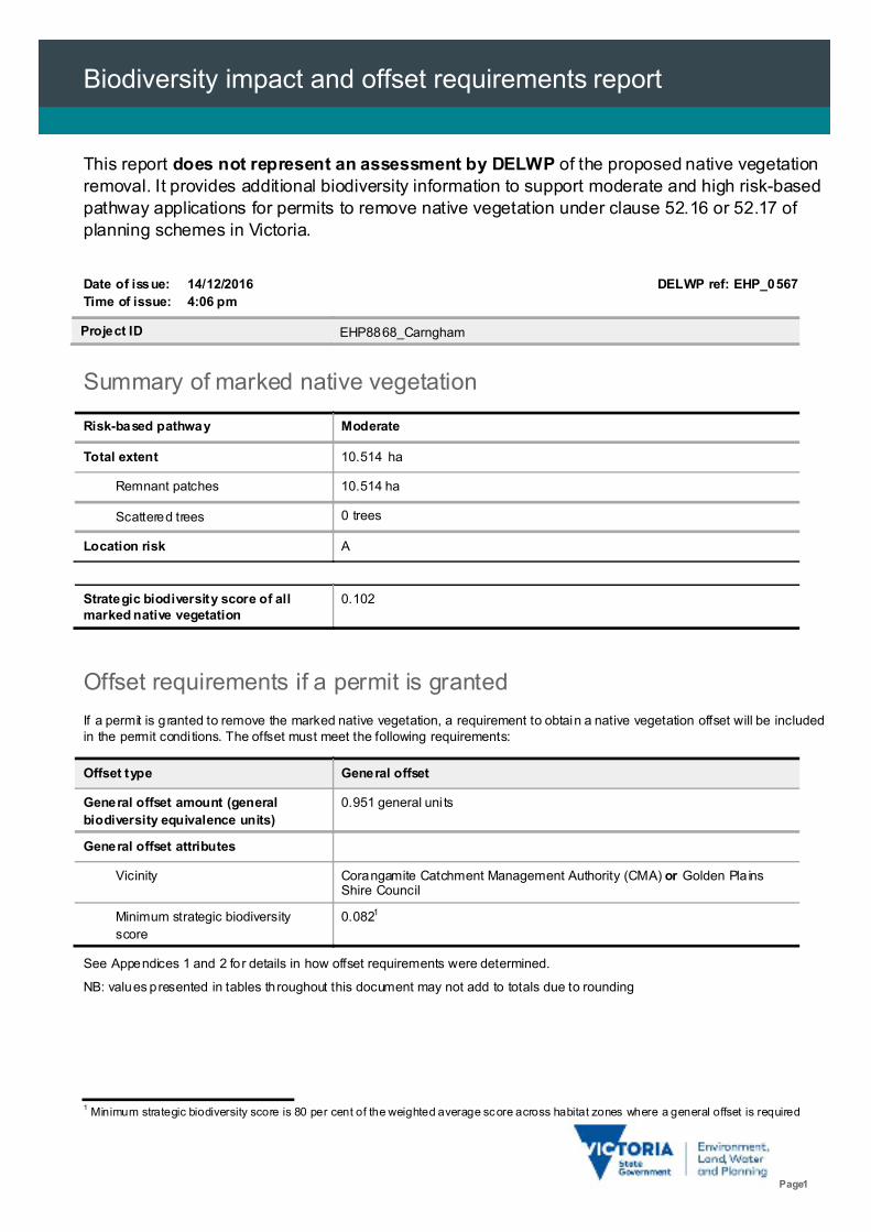
This report does not represent an assessment by DELWP of the proposed native vegetationremoval. It provides additional biodiversity information to support moderate and high risk-basedpathway applications for permits to remove native vegetation under clause 52.16 or 52.17 ofplanning schemes in Victoria.
Date of issue: 14/12/2016 DELWP ref: EHP_0567
Time of issue: 4:06 pm
Project ID EHP8868_Carngham
Summary of marked native vegetation
Risk-based pathway Moderate
Total extent 10.514 ha
Remnant patches 10.514 ha
Scattered trees 0 trees
Location risk A
Offset requirements if a permit is granted
If a permit is granted to remove the marked native vegetation, a requirement to obtain a native vegetation offset will be includedin the permit condi tions. The offset must meet the following requirements:
Offset type General offset
General offset amount (general
biodiversity equivalence units)
0.951 general uni ts
General offset attributes
Vicinity Corangamite Catchment Management Authority (CMA) or Golden Pla insShire Council
Minimum strategic biodiversity
score
0.0821
See Appendices 1 and 2 for details in how offset requirements were determined.
NB: values presented in tables throughout this document may not add to totals due to rounding
1 Minimum strategic biodiversity score is 80 per cent of the weighted average score across habitat zones where a general offset is required
Strategic biodiversity score of allmarked native vegetation
0.102
Biodiversity impact and offset requirements report
Page 2
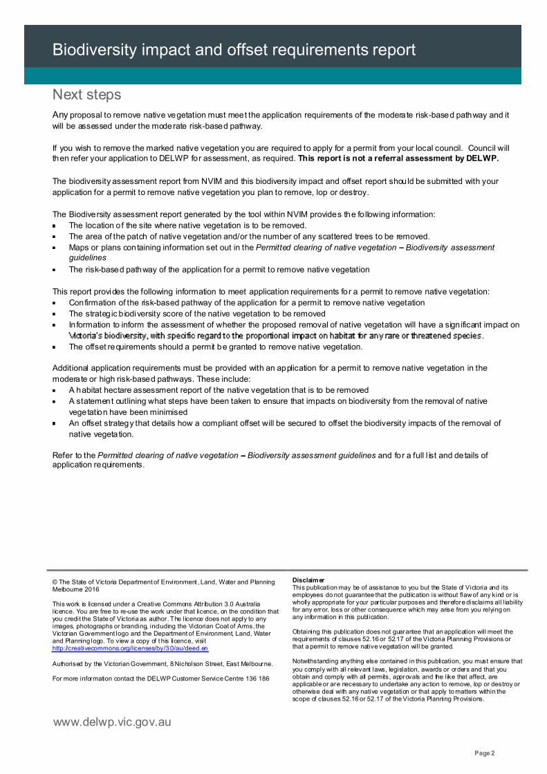
Next stepsAny proposal to remove native vegetation must meet the application requirements of the moderate risk-based pathway and it
will be assessed under the moderate risk-based pathway.
If you wish to remove the marked native vegetation you are required to apply for a permit from your local council. Council willthen refer your application to DELWP for assessment, as required. This report is not a referral assessment by DELWP.
The biodiversity assessment report from NVIM and this biodiversity impact and offset report should be submitted with your
application for a permit to remove native vegetation you plan to remove, lop or destroy.
The Biodiversity assessment report generated by the tool within NVIM provides the fo llowing information:
The location of the site where native vegetation is to be removed.
The area of the patch of native vegetation and/or the number of any scattered trees to be removed.
Maps or plans containing information set out in the Permitted clearing of native vegetation Biodiversity assessmentguidelines
The risk-based pathway of the application for a permit to remove native vegetation
This report provides the following information to meet application requirements for a permit to remove native vegetation:
Confirmation of the risk-based pathway of the application for a permit to remove native vegetation
The strateg ic b iodiversity score of the native vegetation to be removed
Information to inform the assessment of whether the proposed removal of native vegetation will have a sign ificant impact on
.
The offset requirements should a permit be granted to remove native vegetation.
Additional application requirements must be provided with an application for a permit to remove native vegetation in the
moderate or high risk-based pathways. These include:
A habitat hectare assessment report of the native vegetation that is to be removed
A statement outlining what steps have been taken to ensure that impacts on biodiversity from the removal of native
vegetation have been minimised
An offset strategy that details how a compliant offset will be secured to offset the biodiversity impacts of the removal of
native vegetation.
Refer to the Permitted clearing of native vegetation Biodiversity assessment guidelines and for a full l ist and details ofapplication requirements.
© The State of Victoria Department of Environment , Land, Water and PlanningMelbourne 2016
This work is licensed under a Creative Commons Attr ibution 3.0 Australialicence. You are free to re-use the work under that licence, on the condition thatyou credit the State of Victoria as author. The licence does not apply to anyimages, photographs or branding, including the Victorian Coat of Arms, theVictor ian Government logo and the Department of Environment, Land, Waterand Planning logo. To view a copy of t his licence, visithttp://creativecommons.org/licenses/by/3.0/au/deed.en
Authorised by the Victorian Government, 8 Nicholson Street, East Melbourne.
For more information contact the DELWP Customer Service Centre 136 186
DisclaimerThis publication may be of assistance to you but the State of Victoria and itsemployees do not guarantee that the publication is without flawof any kind or iswholly appropriate for your particular purposes and therefore disclaims all liabilityfor any error, loss or other consequence which may arise from you relying onany information in this publication.
Obtaining this publication does not guarantee that an application will meet therequirements of clauses 52.16 or 52.17 of the Victoria Planning Provisions orthat a permit to remove native vegetation will be granted.
Notwithstanding anything else contained in this publication, you must ensure that
you comply with all relevant laws, legislation, awards or orders and that youobtain and comply with all permits, approvals and the like that affect, areapplicable or are necessary to undertake any action to remove, lop or destroy orotherwise deal with any native vegetation or that apply to matters within thescope of clauses 52.16 or 52.17 of the Victoria Planning Provisions.
www.delwp.vic.gov.au
Biodiversity impact and offset requirements report
Page 3
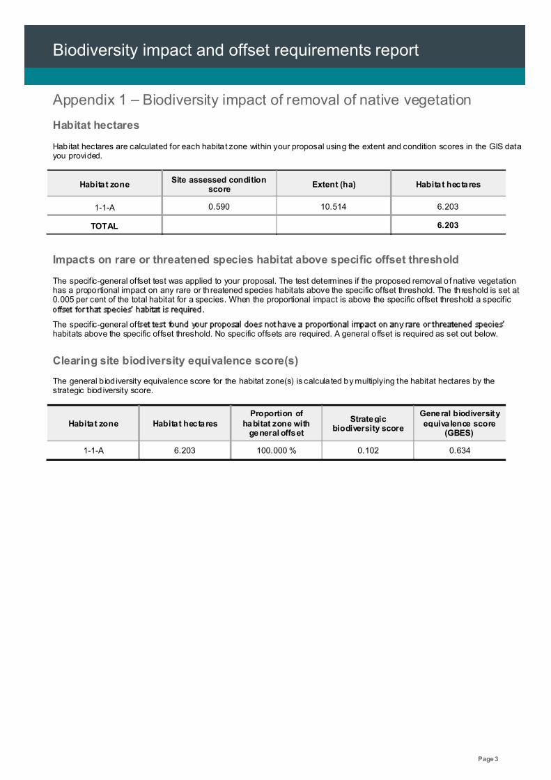
Appendix 1 Biodiversity impact of removal of native vegetation
Habitat hectares
Habitat hectares are calculated for each habita t zone within your proposal using the extent and condition scores in the GIS datayou provided.
Habitat zoneSite assessed condition
scoreExtent (ha) Habitat hectares
1-1-A 0.590 10.514 6.203
TOTAL 6.203
Impacts on rare or threatened species habitat above specific offset threshold
The specific-general offset test was applied to your proposal. The test determines if the proposed removal of native vegetationhas a proportional impact on any rare or threatened species habitats above the specific offset threshold. The threshold is set at0.005 per cent of the total habitat for a species. When the proportional impact is above the specific offset threshold a specific
The specific-general offhabitats above the specific offset threshold. No specific offsets are required. A general o ffset is required as set out below.
Clearing site biodiversity equivalence score(s)
The general b iod iversity equivalence score for the habitat zone(s) is calcula ted by multiplying the habitat hectares by thestrategic biod iversity score.
Habitat zone Habitat hectaresProportion of
habitat zone withgeneral offset
Strategicbiodiversity score
General biodiversityequivalence score
(GBES)
1-1-A 6.203 100.000 % 0.102 0.634
Biodiversity impact and offset requirements report
Page 4
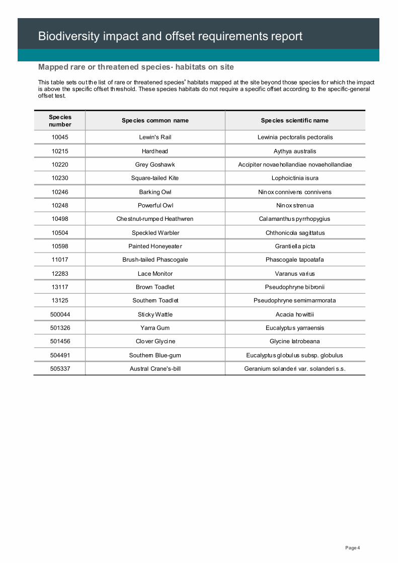
Mapped rare or threatened species habitats on site
This table sets out the list of rare or threatened species habitats mapped at the site beyond those species for which the impactis above the specific offset threshold. These species habitats do not require a specific offset according to the specific-generaloffset test.
Speciesnumber
Species common name Species scientific name
10045 Lewin's Rail Lewinia pectoralis pectoralis
10215 Hardhead Aythya australis
10220 Grey Goshawk Accipiter novaehollandiae novaehollandiae
10230 Square-tailed Kite Lophoictinia isura
10246 Barking Owl Ninox connivens connivens
10248 Powerful Owl Ninox strenua
10498 Chestnut-rumped Heathwren Calamanthus pyrrhopygius
10504 Speckled Warbler Chthonicola sagittatus
10598 Painted Honeyeater Grantiella picta
11017 Brush-tailed Phascogale Phascogale tapoatafa
12283 Lace Monitor Varanus varius
13117 Brown Toadlet Pseudophryne bibronii
13125 Southern Toadlet Pseudophryne semimarmorata
500044 Sticky Wattle Acacia howittii
501326 Yarra Gum Eucalyptus yarraensis
501456 Clover Glycine Glycine latrobeana
504491 Southern Blue-gum Eucalyptus globulus subsp. globulus
505337 Austral Crane's-bill Geranium solanderi var. solanderi s.s.
Biodiversity impact and offset requirements report
Page 5
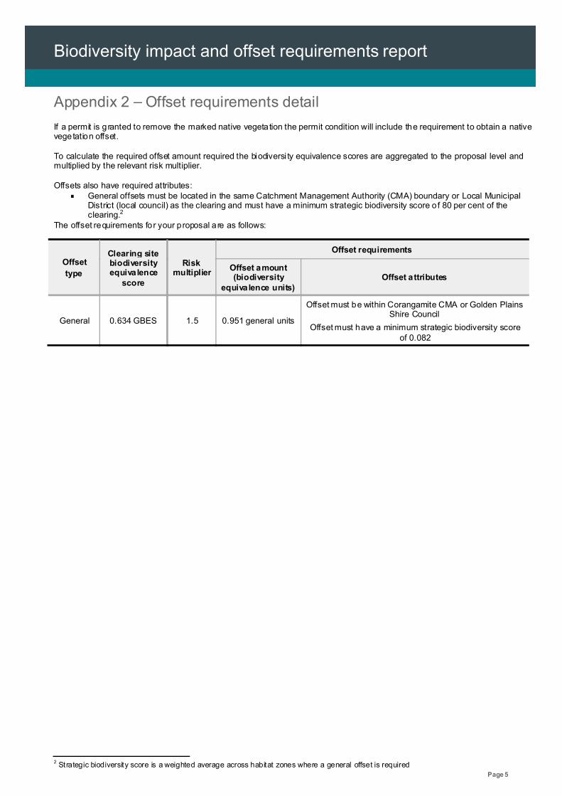
Appendix 2 Offset requirements detail
If a permit is granted to remove the marked native vegetation the permit condition will include the requirement to obtain a nativevegetation offset.
To calculate the required offset amount required the biodiversi ty equivalence scores are aggregated to the proposal level andmultiplied by the relevant risk multiplier.
Offsets also have required attributes:General offsets must be located in the same Catchment Management Authority (CMA) boundary or Local MunicipalDistrict (local council) as the clearing and must have a minimum strategic biodiversity score of 80 per cent of theclearing.2
The offset requirements for your proposal are as follows:
Offset
type
Clearing sitebiodiversityequivalence
score
Riskmultiplier
Offset requirements
Offset amount(biodiversity
equivalence units)Offset attributes
General 0.634 GBES 1.5 0.951 general units
Offset must be within Corangamite CMA or Golden PlainsShire Council
Offset must have a minimum strategic biodiversity scoreof 0.082
2 Strategic biodiversity score is a weighted average across habitat zones where a general offset is required

Biodiversity impact and offset requirements report
Page 6
Appendix 3 Images of marked native vegetation
1. Native vegetation location risk map
2. Strategic biodiversity score map
Biodiversity impact and offset requirements report
Page 7
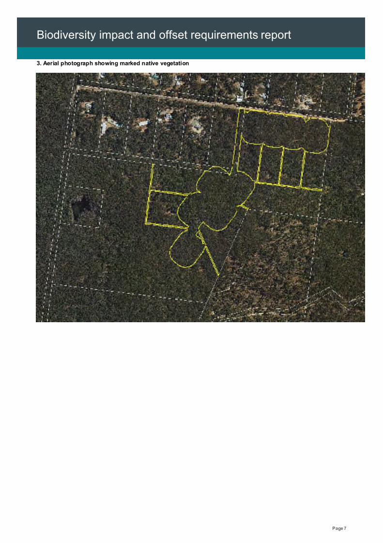
3. Aerial photograph showing marked native vegetation
Biodiversity impact and offset requirements report
Page 8
Glossary
Condition score This is the site-assessed condition score for the native vegetation. Each habitat zone in the
clearing proposal is assigned a condition score according to the habitat hectare assessment
method. This information has been provided by or on behalf of the applicant in the GIS file.
Dispersed habitat A dispersed species habitat is a habitat for a rare or threatened species whose habitat is
spread over a relatively broad geographic area greater than 2,000 hectares.
General biodiversity
equivalence score
The general b iod iversity equivalence score quantifies the relative overall contribution that the
biodiversity. The general biodiversity
equivalence score is calculated as follows:
General offset amount This is calcula ted by multiplying the general biodiversity equivalence score of the native
vegetation to be removed by the risk factor for general offsets. This number is expressed in
general biodiversity equivalence units and is the amount of offset that is required to be
provided should the application be approved. This offset requirement will be a condition to the
permit for the removal of native vegetation.
General offset attributes General offset must be located in the same Catchment Management Authority boundary or
Municipal District (local council) as the clearing site. They must also have a strategicbiodiversity score that is at least 80 per cent of the score of the clearing site.
Habitat hectares Habitat hectares is a site-based measure that combines extent and condition of native
vegetation. The habitat hectares of native vegetation is equal to the current condition of the
vegetation (condition score) multiplied by the extent of native vegetation. Habitat hectares can
be calcu lated for a remnant patch or for scattered trees or a combination of these two
vegetation types. This value is calcu lated for each habitat zone using the following formula:
Habitat importance score The habitat importance score is a measure of the importance of the habitat located on a site
for a particular rare or threatened species. The habitat importance score for a species is a
weighted average value calculated from the habitat importance map for that species. The
habitat importance score is calculated for each habita t zone where the habitat importace map
indicates that species habitat occurs.
Habitat zone Habitat zone is a discrete contiguous area of native vegetation that:
is of a single Ecological Vegetation Class
has the same measured condition.
Biodiversity impact and offset requirements report
Page 9
Highly localised habitat A highly localised habitat is habitat for a rare or threatened species that is spread across a
very restricted area (less than 2,000 hectares). This can also be applied to a similarly limited
sub-habitat that is disproportionately important for a wide-ranging rare or threatened species.
Highly localised habitats have the highest habitat importance score (1) for all locations where
they are present.
Minimum strategic
biodiversity scoreThe minimum strategic biodiversity score is an attribute for a general offset.
The strateg ic b iodiversity score of the offset site must be at least 80 per cent of the strategic
biodiversity score of the native vegetation to be removed. This is to ensure offsets are located
in areas with a strategic value that is comparable to, or better than, the native vegetation to beremoved. Where a specific and general offset is requi red, the minimum strategic biodiversity
score relates only to the habitat zones that require the general offset.
Offset risk factor There is a risk that the gain from undertaking the offset will not adequately compensate for the
loss from the removal of native vegetation. If this were to occur, despite obtaining an offset, the
overal l impact from removing native vegetation would result in a loss in the contribution that
To address the risk of offsets failing, an offset risk factor is applied to the calculated loss to
biodiversity value from removing native vegetation.
Offset type The specific-general offset test determines the offset type required.
When the specific-general offset test determines that the native vegetation removal will have
an impact on one or more rare or threatened species habitat above the set threshold of 0.005
per cent, a specific offset is required. This test is done at the permi t appl ication level.
A genera l offset is required when a proposal to remove native vegetation is not deemed, by
application of the specific-general offset test, to have an impact on any habitat for any rare or
threatened species above the set threshold of 0.005 per cent. All habitat zones that do not
require a speci fic offset will require a general offset.
Proportional impact on
species
This is the outcome of the specific-general offset test. The specific-general offset test is
calcula ted across the entire proposal for each species on the native vegetation permitted
clearing species list. If the proportional impact on a species is above the set threshold of0.005 per cent then a specific offset is required for that species.
Specific offset amount The specific offset amount is calculated by multiplying the specific biodiversity equivalence
score of the native vegetation to be removed by the risk factor for specific offsets. This number
is expressed in specific biodiversity equivalence units and is the amount of offset that is
required to be provided should the application be approved. This offset requirement will be a
condition to the permit for the removal of native vegetation.
Biodiversity impact and offset requirements report
Page 10
Specific offset attributes Specific offsets must be located in the modelled habitat for the species that has triggered the
specific offset requirement.
Specific biodiversity
equivalence score
The specific biod iversity equivalence score quantifies the relative overall contribution that the
native vegetation to be removed makes to the habitat of the relevant rare or threatened
species. It is calculated for each habita t zone where one or more species habitats require a
specific offset as a result of the specific-general offset test as follows:
Strategic biodiversity
score
This is the weighted average strategic biodiversity score of the marked native vegetation. The
strategic biod iversity score has been calculated from the Strategic biodiversity map for each
habitat zone.
Stra tegic biodiversity map is a modelled layer that prioritises locations on the basis of rarity
and level of depletion of the types of vegetation, species habitats, and condition and
connectivity of native vegetation.
Total extent (hectares)
for calculating habitat
hectares
This is the total area of the marked native vegetation in hectares.
The total extent of native vegetation is an input to calculating the habitat hectares of a site and
in calcu lating the general biodiversity equivalence score. Where the marked native vegetation
includes scattered trees, each tree is converted to hectares using a standard area calculation
of 0.071 hectares per tree. This information has been provided by or on behalf of the applicant
in the GIS file.
Vicinity The vicinity is an attribute for a general offset.
The offset site must be located within the same Catchment Management Authority boundary or
Local Municipal District as the native vegetation to be removed.