Embed Size (px)
Citation preview
Page 0 of 40
Climate Summit for a LIVING HIMALAYS
Bhutan 2011
Securing BIODIVERSITY
Bangladesh National Roadmap
2012 - 2021
Page 1 of 40
Table of Content
1. Declaration 2
2. Executive Summary 2
3. Introduction 5
3.1 Country Description and relation to E. Himalayas 6
3.2 Potential Impacts (issues) of Climate Change on the Country 8
3.3 Process in Preparing National Document/ Linkage to national policies
and priorities and other climate change plans and strategies
13
4. Situation Analysis 14
5. National Roadmap 28
6. Regional Issues and Concerns of Biodiversity Conservation 29
7. Duration/Timeline of Roadmap 32
8. Priority Action Plan 32
9. Implementation Arrangement 34
9.1 Institutional Arrangement 34
9.2 Financial Mechanism towards implementation of the Road Map 35
10. Monitoring and Review 35

Page 2 of 40
1. Declaration
Recognizing the significance of biodiversity conservation in the Eastern Himalayas region , this
roadmap provides the current status of biodiversity, progress made on biodiversity conservation
in the region, challenges and barriers to be overcome, linkages of livelihoods and sustainable
use of biodiversity, priority actions for protecting biodiversity from impacts of climate change,
groundbreaking regional achievements and future directions for biodiversity conservation.
It is important to take immediate actions at a regional scale in the critical ecological areas for
halting biodiversity loss and habitat degradation, transboundary pollution control, establishing
biological corridors and ensuring minimum environmental flow for ecological processes.
Therefore, the countries of the Eastern Himalayas approved the roadmap for its implementation
within the scope of regional cooperation by sharing knowledge, skills and resources.
2. Executive Summary
The Bhutan Climate Summit 2011 which will focus on southern slopes of the eastern Himalayas
(includes Bangladesh, Bhutan, India and Nepal) is being organized to create awareness and raise
the concerns of the mountainous countries on melting glaciers and glacial lake outburst floods
which has not received the same level of attention as the concerns of island nations and coastal
regions on rising sea levels and melting polar ice caps. Consequently, mountain regions, like the
Himalayas, run the risk of being left out of the climate change discourse and limit their access to
mechanisms and resources for implementing mitigation and adaptation measures.
Eastern Himalayan countries are deeply concerned that the adverse impacts of climate change
have already made severe degradation of the ecosystems and the biodiversity as a whole those
are providing the valuable livelihood support to millions of poor people living in the region. The
sustainable development and the very existence of the Eastern Himalayan countries would be
jeopardised unless the biodiversity and ecosystems of the regions are conserved particularly
focusing climate change impacts. As the Eastern Himalayan region is facing the catastrophic
consequences of accelerated glacier melt, including Glacial Lake Outburst Floods (GLOF)
common but differentiated efforts would be vital to address the challenges of climate change
and conservation of Biodiversity. Considering the highest level of vulnerabilities, inadequate
means of support and limited capacities, it is critical to develop common understanding for
prioritizing action plan and implementation to conserve biodiversity and ecosystems to make
these more resilient to climate change. To this end, the eastern Himalayan countries would
implement the following activities towards conservation of Biodiversity and ensuring our
sustainable future in face of climate change, and climate extremities.
The Summit aims to develop and agree on a roadmap for adapting climate change in the
Himalayas, particularly across the southern face of the Eastern Himalayas; highlight the issues of
Page 3 of 40
climate change and its impacts on the Himalayas; foster partnership and networking to facilitate
sharing of information and experience; and to lobby for bringing attention to the impacts of
climate change on the world mountains.
During the Country Focal Person’s Meeting in January 2011 held in Thimphu the focal person
from the four countries; Bhutan, India, Bangladesh and Nepal; agreed that there is need to build
resilience to the impacts of climate change and generate resources for adaptation, capacity
building and technology transfer.
Acknowledging the fact that there is rapid melting of glaciers in the Eastern Himalayan region
and threat of Glacial Lake Outburst Flow (GLOF) is persistent in the region, including coastal
areas, an indication of changing climate. All four countries agreed that time have come to think
about preventive measures of climate change hazards.
The Country Focal Person’s Meeting concluded that there is a need to adopt a roadmap for
adaptation to climate change in the Eastern Himalayan region for ensuring food, water, energy
and maintaining biodiversity and eco-system. To identify and address the issues on four key
thematic concerns of food, energy, water and biodiversity, the four countries sharing geographic
commonalities in southern watershed of the Eastern Himalaya, have agreed to build a national
road map which will put forward to build a regional roadmap for ten years.
Following the decisions taken at the Country Focal Person’s Meeting, The Ministry of
Environment and Forests have formed a Technical Expert Group to prepare the National
Biodiversity Roadmap. After having a series of discussion meetings, the group has developed an
extended contents based on the content provided by the organizer. The group was subdivided
to work on different parts of the contents. The first draft of the National Roadmap was
developed by 15 May 2011 and was subsequently revised by the members. Soon after, on 21
may 2011, a workshop “Road to Climate Summit for a Living Himalayas: Development of Country
Position Papers and Roadmaps” was organized with an objective to share the national roadmaps
developed for the upcoming summit and taking feedback from the experts and civil society
group.
The National roadmap has analyzed the existing situation of biodiversity of the region with a
particular focus on protected area management, conservation strategies, current status of
biodiversity and environmental management. After analyzing the situation, the roadmap
formulated some strategies based on national and regional context which will eventually benefit
the region as a whole for continuing goods and services of biodiversity and ecosystems to
support livelihood of millions.

Page 4 of 40
3. Introduction:
Fast change in climate has adverse impacts on biodiversity which is the main service provider of
water, food and energy. There is an urgent need to develop climate resilient a roadmap to
conserve biodiversity along with ecosystem goods and services in the Eastern Himalayan region.
This was discussed during the Country Focal Person’s Meeting in January 2011 held in Thimphu.
The focal person from the four countries; Bhutan, India, Bangladesh and Nepal; agreed that
there is need to build resilience to the impacts of climate change and generate resources for
adaptation, capacity building and technology transfer.
Acknowledging the fact that there is rapid melting of glaciers in the Eastern Himalayan region
and threat of Glacial Lake Outburst Flow (GLOF) is persistent in the region, including coastal
areas, an indication of changing climate. Even the farmers in remote part of Bhutan complained
that rainfall pattern is fast changing and weather becoming unpredictable. All four countries
agreed that time have come to think about preventive measures of climate change hazards. Due
to the adverse impacts of change in climate, tigers in lowland have started seeking its habitation
in the sub-tropical regions. If it continues to migrate uphill, the snow-leopard will eventually be
threatened. It will extinct and such is the fear of climate change on biodiversity and eco-system.
The speakers of the Country Focal Person’s Meeting concluded that there is a need to adopt a
road map for adaptation to climate change in the Eastern Himalayan region for ensuring food,
water, energy and maintaining biodiversity and eco-system. To identify and address the issues
on four key thematic concerns of food, energy, water and biodiversity, the four countries
sharing geographic commonalities in southern watershed of the Eastern Himalaya, have agreed
to build a national road map which will put forward to build a regional road map for ten years.
India will be leading the food security issues while Bangladesh will lead water security. Given the
rich biodiversity and eco-system in the region, Bhutan will work on ensuring biodiversity in the
region while Nepal will have to take care of energy security. On one hand, there is a shortage of
drinking water in the region because of rapid global warming, but on the other there is a serious
threat of water related hazards. The collective efforts in mitigating the water related hazards
have become very important in the region. Climate change has direct implications on agro-
ecosystem affecting all agricultural subsectors. The temperature rise, glacier melt, extreme
events like flashflood and drought, and erratic rainfalls cause changes in the hydrological cycle
and soil composition affecting the entire biophysical processes and services associated with
agro-ecosystem. A great majority of people in living in the Eastern Himalaya depend on
ecosystem for energy. Climate change will have an adverse impact on hydropower and biomass.
Therefore, access to electricity/cooking and heating fuel' is an issue in the context of climate
change in the Eastern Himalayas that also signify the need for reduce dependency on biomass
energy generation which is not climate friendly. The region presently faces some key problems
like reduced per capita agriculture land, land degradation, decreased productivity, loss of local
crop generic resources, water scarcity and loss of traditional farming technologies.
Page 5 of 40
This Country Roadmap has been formulated reviewing the existing policy documents of
Bangladesh and in the process of expert level consultation. This document is prepared with the
modest support of Bhutan Climate Summit 2011 Secretariat. Facts and figures of the country
road map are adopted from different secondary sources those have been properly cited as
reference.
The regional road map will be harmonized and consolidated during a group consolidation
meeting. The harmonized roadmap and a draft declaration developed from the experts and
group consolidation meeting which will be presented to the ministerial meeting for finalization
and adoption. The Summit will be convened on the October 14 in Bhutan.
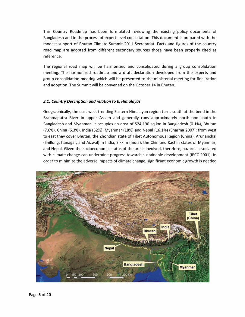
3.1. Country Description and relation to E. Himalayas
Geographically, the east-west trending Eastern Himalayan region turns south at the bend in the
Brahmaputra River in upper Assam and generally runs approximately north and south in
Bangladesh and Myanmar. It occupies an area of 524,190 sq.km in Bangladesh (0.1%), Bhutan
(7.6%), China (6.3%), India (52%), Myanmar (18%) and Nepal (16.1%) (Sharma 2007): from west
to east they cover Bhutan, the Zhondian state of Tibet Autonomous Region (China), Arunanchal
(Shillong, Itanagar, and Aizwal) in India, Sikkim (India), the Chin and Kachin states of Myanmar,
and Nepal. Given the socioeconomic status of the areas involved, therefore, hazards associated
with climate change can undermine progress towards sustainable development (IPCC 2001). In
order to minimize the adverse impacts of climate change, significant economic growth is needed
Page 6 of 40
in the countries of the Eastern Himalayas so that they are capable of adopting the necessary
measures.
The Bengal basin of Bangladesh is filled mainly by orogenic sediment derived from the eastern
Himalayas to the north and the Indo-Burman ranges to the east. A major palaeo-drainage
system (Siwalik river or Indo-Brahm river) flowed from the eastern Himalayas draining through
present day Assam and bringing orogenic sediments into the Sylhet trough (surma basin) from
the east. The Indo-Burman ranges contributed sediment into the Chittagong area, but the major
sediment source for Miocene strata of the Bengal Basin was likely the early uplifts of the eastern
Himalayas. The climate of the Eastern Himalayas is influenced strongly by the Asian monsoon
system. The vast Tibetan Plateau is an engine driving the monsoon system by generating a high-
altitude region of low pressure cells over southern Asia in response to the heating of the
Eurasian landmass (which includes Bangladesh, India, Nepal, Pakistan, and Sri Lanka) in summer,
with the hot air replaced by cooler air coming from the Arabian sea and Indian Ocean
(Hastenrath 1991). During summer, the monsoon causes intense precipitation over eastern India
and the Eastern Himalayas due to the orographic effects of the Himalayas on moist air
advancing towards the plateau from the Indian Ocean as a consequence of the low-high
pressure gradient: the flow patterns are reversed in winter with cool and dry air dominating
over south-central Asia (Johnson and Houze 1987; Murakami 1987, Gregory 1989; Clemens et al.
1991).The Eastern Himalayas are subject to the southwest monsoon in the summer and the
northeast monsoon in winter. Climate and weather in the mountains are extremely variable and
influenced by altitude, latitude, topography, orientation, and continental position (Barry and
Chorley 1992). Instrumental meteorological records show a global warming trend of 0.74°C in a
100-year period (1906-2005) (IPCC 2007). In contrast the higher Himalayan data from Nepal
over the period from 1977- 1994 show an increase in temperature of up to 0.06°C per year,
which is greater than the global trend (Shrestha et al.1999).
Warming in the Himalayas is demonstrated by the increased rate of glacial recession and the
resultant formation of new glacial lakes in the high Himalayas (e.g., Mool et al. 2001a). The
recorded rate of glacial retreat varies across the Himalayas. One reason is the variability in
monsoon intensity (Karma et al. 2003). Within basins, the orientation and position of a glacier,
different meteorological conditions in the valleys, and amount of debris and distribution on and
in the glacial mass, all play a role, as does the irregular carving of glaciers at the glacier end
where the solid phase of water comes into contact with the liquid phase (Ageta et al. 2001).
Research is needed to decipher the controlling mechanisms and determine the causes of these
changes in glacial melt velocity. In some cases the rate of retreat has increased in recent years.
Gangotri glacier in the western Himalayas (India) showed a more rapid rate of retreat after the
seventies, increasing from 15 m/yr from 1935 to1976, to 23 m/yr from 1985 to 2001. The rate of
retreat of the Imja glacier in Nepal almost doubled after 2001. One of the causes of acceleration
in glacial retreat is probably the increased warming trend in the High Himalayas (Shrestha et al.
1999).

Page 7 of 40
The Eastern Himalayas can be broadly divided into the following distinct, geomorphologic units
from south to north as proposed by Upreti (1999); Alam and Tshering (2004); and Konagaya
(2005) as follows.
Southern foothills with inner valleys (200 to1,500 masl)
Mahabharat range (1,000 to 3,000 masl)
Midlands (200 to 2,500 masl)
Fore Himalayas (2,500 to 4,000 masl)
High Himalayas (4,000 to 8,848 masl)
Trans-Himalayas with inner valleys (2,500 to 4,500 masl)
The southern foothills suddenly rise from the plains from a height of about 100 m to reach 1,500
m. East-west elongated inner valleys, also called ‘dun valleys’, are located within this zone. The
inner valleys are densely populated. The climatic regime is very similar to that of the plains. The
first orographic barrier of the outer Himalayas, also called the Mahabharat range, rises rapidly to
about 3,000 m. The topography of the area is rugged and steeper in the western part than in the
eastern part. The relatively mature and subdued geomorphic zone to the north of the
Mahabharat Range is known as the Midland zone. The altitude of the area varies from 200 to
2,500 m and contains a large number of wide river valleys and intermontane basins: it is a
densely populated zone. To the north of the Midlands are the Fore Himalayas with altitudes
ranging from 2,500 to 4,000 m. The Fore Himalayan zone is denoted as the Central Mountain
zone in Bhutan. The high-altitude area of the Fore Himalayan zone is covered by snow during
winter. The High Himalayan zone with heights ranging from 4,000 to 8,848 m includes peaks
such as Annapurna, Manaslu, Mount Everest, and Kangchenjunga. Most of the glaciers, glacial
lakes, and snow peaks are found in this zone. The trans-Himalayas contain inner valleys ranging
in height from 2,500 to 4,500 m. The mountainous ranges in the eastern part of the East
Himalayas (Bangladesh, east India, and Myanmar) have north-south directed trends. The
mountain area in Bangladesh reaches a height of 1,003 m.
Biodiversity in mountain areas where migration of species is physically restricted will be
threatened by rapid changes in temperature and precipitation. Consequently there could be
rapid losses of habitat and genetic diversity from the mountain ecosystem. Infrastructure in the
mountains and downstream could be threatened. All of these impacts will interact with one
another, often in unexpected ways, in some cases resulting in greater impacts, in some cases
partially compensating for each other (Eamer et al. 2007). In many developing countries, there is
widespread poverty, poor health, and bad sanitation, in part because of the degradation of the
natural environment (Price et al. 2000). If the climate in the Himalayan region changes according
to the present predictions, it will have serious consequences on the livelihoods of people in the
region.
Page 8 of 40
3.2. Potential Impacts (issues) of Climate Change on the Country
Bangladesh is already vulnerable to many gradual change phenomena of climate change as well
as climate change related extreme events. It is expected that climate change will bring changes
in characteristics of gradual change phenomenon and natural hazards which will result changes
in physical, social and production system. Studies and assessments on impacts, vulnerabilities
and adaptation to climate change and sea level rise for Bangladesh clearly demonstrate that
Bangladesh is one of the most climate vulnerable countries in the world. Rainfall is predicted to
become higher and more erratic. Frequency and intensity of natural disasters are likely to
increase especially in the northern and western part of the country. Several early evidences of
the above phenomenon and its associated impacts in the agriculture, health, water and
sanitation, biodiversity are already visible in Bangladesh.
The observed climatic data from 1971 to 2002 indicates that the temperature is generally
increasing in the monsoon season (June, July and August). The average monsoon maximum and
minimum temperatures show an increasing trend annually at 0.05°C and 0.03°C, respectively.
Average winter season (December, January and February) maximum and minimum temperature
show respectively a decreasing and an increasing trend annually at 0.001°C and 0.016°C
(Rahman Alam: 2003). It is also revealed that 1998 was the warmest year in the last 30 years.
Observed data of the Rangpur Station from 1978 to 2002 indicates that overall annual maximum
and minimum temperature is generally increasing annually at the rate of 0.035°C and 0.027°C,
respectively. However, rate of change of maximum temperature in the monsoon season is
slightly lower than annual rate of change. In monsoon season (June, July and August), average
maximum temperature shows an increasing trend annually at the rate of 0.02°C while changes
in minimum temperature in the monsoon season is insignificant. On the other hand average
maximum temperature in winter season (December, January and February) shows an increasing
trend annually at the rate of 0.041°C while minimum temperature shows an increasing trend
annually at the rate of 0.026°C which reflects winter is also becoming warmer.
The mean annual rainfall of the country is about 2300mm, but there exists a wide spatial and
temporal distribution. Annual rainfall ranges from 1200mm in the extreme west to over
5000mm in the east and north-east (MPO, 1991). It is 1220 mm in the north-western part,
1490mm in the central part, 3380mm in the coastal areas, and over 5000mm in the north-
eastern part - across the borders from Cherapunji and Mawsyriem, two of the rainiest places in
the world (Rashid, 1991). Possible connections with El Nino have only now begun to attract
attention as a major possible influence on climatic patterns in the Sub-continent.
It was observed that the last monsoon (2006) there was lower rainfall resulted in reduction of
Aman crop production of about 25-30% (Karim, 2006). The most remarkable change of rainfall is
the change in duration of rainy season. Bangladesh NAPA states that the duration of rainy
season has been decreased but the total annual rainfall remains more or less same. It means

Page 9 of 40
that heavy rainfall is occurred within short period. This behaviour of rainfall mostly affects
agriculture sector and other livelihood systems.
Change in the sea level at local level depends on several factors and therefore future sea level rise projected in the assessment report of the Intergovernmental Panel on Climate Change (IPCC) will not be uniform all over world. One of the critical factors related to Bangladesh coast is vertical land movement (subsidence/uplift). Seasonal variation of salinity intrusion also depends on freshwater flow in the river system and cyclonic storm surges. The SAARC Meteorological Research Council (SMRC) carried out a study on recent relative sea level rise in the Bangladesh coast. The study has used 22 years historical tidal data of the three coastal stations. The study revealed that the rate of sea level rise during the last 22 years is many fold higher than the mean rate of global sea level rise over 100 years, which shown the important effect of the regional tectonic subsidence. Variation among the stations was also found. The following table represents the trend of tidal level in three costal stations.
Table 1: Tidal Trend in three coastal stations
Tidal Station Region Latitude (N) Longitude (E) Datum (m) Trend
(mm/year)
Hiron Point Western 21O48’ 89
O28’ 3.784 4.0
Char Changa Central 22O08’ 91
O06’ 4.996 6.0
Cox’s Bazar Eastern 21O26’ 91
O59’ 4.836 7.8
Source: SMRC, No. 3
Natural disaster is a regular phenomenon in Bangladesh. Key natural disasters are riverine and flash flood, tropical cyclones, tornados, and droughts due to its unique geographical location (Himalaya to the north and Bay of Bengal to the south). It is reported that between 1991 and 2000, 93 major disasters occurred in Bangladesh, resulting in nearly 200,000 deaths and causing US $ 5.9 billion in damages with high losses in agriculture and infrastructure (CCC, 2007). Since then, the country is experiencing extreme climatic events frequently. It is revealed from the disaster records of last three decades that frequency of natural disasters has increased over time. The following table shows that frequency of flood and tornado has increased in last two decades.
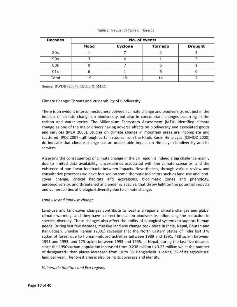
Page 10 of 40
Table 2: Frequency Table of Hazards
Decades No. of events
Flood Cyclone Tornado Drought
80s 1 7 2 3
90s 3 4 1 3
00s 9 7 6 1
01s 6 1 5 0
Total 19 19 14 7
Source: BWDB (2007), CEGIS & SMRC
Climate Change: Threats and Vulnerability of Biodiversity There is an evident interconnectedness between climate change and biodiversity, not just in the impacts of climate change on biodiversity but also in concomitant changes occurring in the carbon and water cycles. The Millennium Ecosystem Assessment (MEA) identified climate change as one of the major drivers having adverse affects on biodiversity and associated goods and services (MEA 2005). Studies on climate change in mountain areas are incomplete and scattered (IPCC 2007), although certain studies from the Hindu Kush- Himalayas (ICIMOD 2000) do indicate that climate change has an undesirable impact on Himalayan biodiversity and its services. Assessing the consequences of climate change in the EH region is indeed a big challenge mainly due to limited data availability, uncertainties associated with the climate scenarios, and the existence of non-linear feedbacks between impacts. Nevertheless, through various review and consultative processes we have focused on some thematic indicators such as land-use and land-cover change, critical habitats and ecoregions, bioclimatic zones and phenology, agrobiodiversity, and threatened and endemic species, that throw light on the potential impacts and vulnerabilities of biological diversity due to climate change. Land use and land use change Land-use and land-cover changes contribute to local and regional climate changes and global climate warming; and they have a direct impact on biodiversity, influencing the reduction in species’ diversity. These changes also affect the ability of biological systems to support human needs. During last few decades, massive land use change took place in India, Nepal, Bhutan and Bangladesh. Shankar Raman (2001) revealed that the North Eastern states of India lost 378 sq.km of forest due to human-induced activities between 1989 and 1991; 488 sq.km between 1991 and 1993; and 175 sq.km between 1993 and 1995. In Nepal, during the last five decades since the 1950s urban population increased from 0.238 million to 3.23 million while the number of designated urban places increased from 10 to 58. Bangladesh is losing 1% of its agricultural land per year. The forest area is also losing its coverage and identity. Vulnerable Habitats and Eco-regions
Page 11 of 40
Seven ecosystems have been found critical due to the adverse impacts of climate change. Those are:
Alpine/sub-alpine ecosystems nestled between the tree line at 4,000 m to the snowline at 5,500 m
Cool-moist forests
Cloud forests at temperate elevations where moisture tends to mix with other particles and remain in the air
Areas with intensive agriculture
Freshwater wetlands
Riparian habitats nurtured by silt deposited by overflowing rivers
Ephemeral stream habitat Bioclimatic zones and phenology Globally, there is evidence of the shift of species towards the north in latitude or higher elevations, especially for species in the transition zone between subalpine and alpine which are more vulnerable to climate change as they have limited scope for movement. Analyses for the EH are few and limited to certain pockets of areas. Observations have been made about the change in events related to plant and animal phenology and also to shifting of tree lines and encroachment of woody vegetation into alpine meadows. Phenological changes, such as early budding or flowering and ripening of fruits in plants, and hibernation, migration, and breeding in animals, could have adverse impacts on pollination patterns. Consequently, this may have an impact on the population of pollinators, leading to changes in ecosystem productivity and species’ composition in high-altitude habitats (Thuiller et al. 2008). Agro-biodiversity and food security The most vulnerable agro-ecological zone in the EH region is the specialised pastoralist system in the high-altitude areas of Eastern Nepal, Sikkim, Bhutan, Arunachal Pradesh, and the Tibet Autonomous Region of China. The vulnerability of the system is due to land use change caused by shifts in rainfall patterns and loss of vegetation cover. Other agro-ecological zones, such as mixed mountain agro-pastoralism systems; cereal-based hill farming systems; and shifting cultivation areas could also be impacted with changes in precipitation and temperature regimes. In the EH, large tracts of secondary forest have been established and maintained through shifting cultivation practices; and this traditional farming and agro-forestry practice, which used to be subsistence based but sustainable is facing numerous challenges from widespread, modern agricultural development, increasing population pressure, and decreasing fallow cycles. Many indigenous crop varieties are under serious threat, therefore, and this is manifest in commercialization of agriculture, weak policy and regulatory frameworks, increased accessibility, changes in cropping patterns and land-use practices, social inequality, population growth, and technological advancement: all of these contributing to loss of agro-biodiversity (Upreti and Upreti 2002). The prevailing rise in temperature and changes in precipitation patterns leading to increased incidence of extreme weather events and an increase of greenhouse gases in the atmosphere, carbon dioxide (CO2) being the most prominent, are principal factors that could lead to
Page 12 of 40
diminishing crop and livestock diversity and have direct implications on agro-biodiversity and food security in the EH. Changes in weather patterns would make it difficult to determine sowing and harvesting schedules and would hamper selection of suitable crops. Erratic rainfall, in particular, would affect regions already suffering from water shortages. Extreme rainfall events would lead to increased loss of water through runoff. Another negative impact would be a pervasive decrease in soil fertility through loss of carbon from the soil through erosion, reduced soil moisture, and moisture storage capacity. All this could result in reductions in crop yields and agricultural productivity because of the loss of soil fertility and decrease in pollinator populations, with subsequent threats to food security. Complete loss of crops resulting from extreme events, such as prolonged drought and torrential rain, is also possible. In addition, a fall in livestock productivity from heat dissipation and declining availability of feed and fodder; and increased risk of pests and diseases to crops and animals (as well as humans) would bring about changes in the agro-ecological environment. Threats from new invasive plant and animal species would be inevitable. The combined effect of all the factors described could lead to a reduction of agro biodiversity. 3.3. Process in Preparing National Document/ Linkage to national policies and priorities and
other climate change plans and strategies
The biodiversity roadmap for Bhutan Climate Summit 2011 is prepared through consultative processes. The concerned ministries/divisions, research organizations, academics and experts have been involved in this process. The first step for preparing this important document was to formation of technical expert groups. This was initiated through the inception meeting held on 7 April 2011 where formation of the technical expert groups for four thematic areas (water, food, biodiversity and energy) was decided. The Steering Committee headed by the Secretary, MoEF formed a technical expert group to prepare the national roadmap on Biodiversity. The next step was to determine methodology which has been done through technical committee meetings. The technical committee on Biodiversity reviewed relevant literature and prepared a background document on present situation and future trend in Biodiversity. In depth discussions were held through series of consultation meetings among the technical committees, relevant experts, professionals and development agencies by which different strategic areas were identified for intervention at a local as well as regional levels. Also, these consultative meetings engender a draft roadmap which was shared with national level stakeholders through a workshop on 21 May 2011. Recommendations of the national workshop were incorporated in the country roadmap. However, a schematic diagram of preparation of country roadmap on Biodiversity is given below.
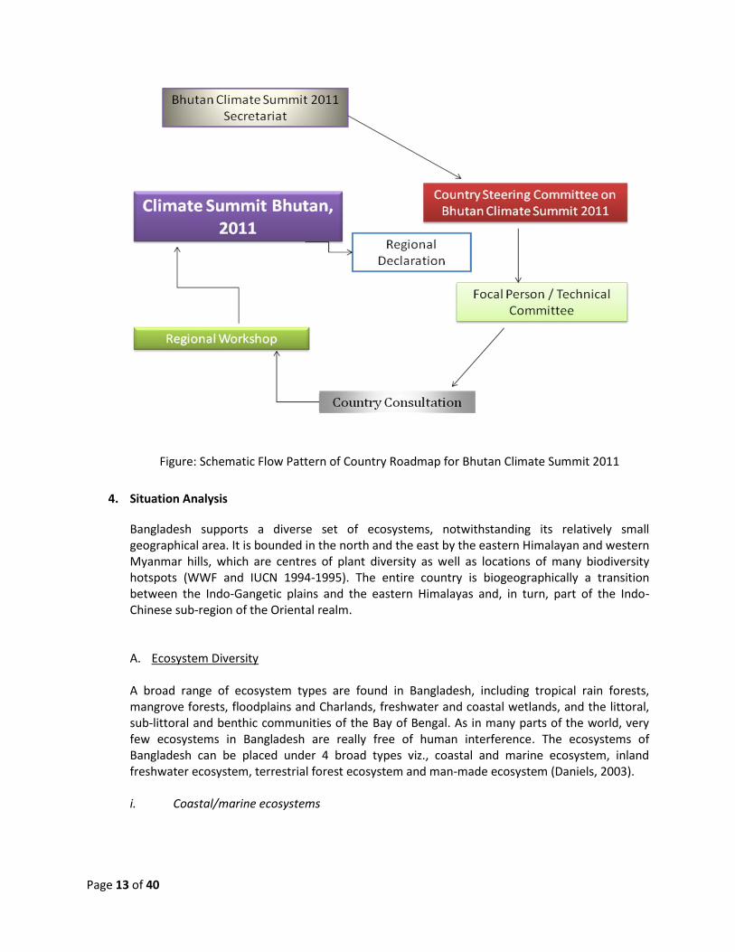
Page 13 of 40
Figure: Schematic Flow Pattern of Country Roadmap for Bhutan Climate Summit 2011
4. Situation Analysis
Bangladesh supports a diverse set of ecosystems, notwithstanding its relatively small geographical area. It is bounded in the north and the east by the eastern Himalayan and western Myanmar hills, which are centres of plant diversity as well as locations of many biodiversity hotspots (WWF and IUCN 1994-1995). The entire country is biogeographically a transition between the Indo-Gangetic plains and the eastern Himalayas and, in turn, part of the Indo-Chinese sub-region of the Oriental realm. A. Ecosystem Diversity A broad range of ecosystem types are found in Bangladesh, including tropical rain forests, mangrove forests, floodplains and Charlands, freshwater and coastal wetlands, and the littoral, sub-littoral and benthic communities of the Bay of Bengal. As in many parts of the world, very few ecosystems in Bangladesh are really free of human interference. The ecosystems of Bangladesh can be placed under 4 broad types viz., coastal and marine ecosystem, inland freshwater ecosystem, terrestrial forest ecosystem and man-made ecosystem (Daniels, 2003). i. Coastal/marine ecosystems
Page 14 of 40
Worldwide, Bangladesh is best known for its extensive coastal and marine ecosystems. The Sundarbans is of global importance as the largest mangrove forest in the world and the Cox’s Bazar is distinguished as the world’s longest beach. A large number of offshore islands are scattered in the Bay of Bengal. Narikel Jinjira is the only coral is bearing island of Bangladesh, and therefore it is of significance in the context of coastal and marine ecosystems. Estuarine flood plains, sand dunes and beaches characterize the coastal ecosystems of Bangladesh. The Meghna flood plains of Noakhali and Lakshmipur districts are inundated by saltwater, seasonally, which attracts a wide variety of birds, including migratory ones. Rare species of birds including the Indian skimmer (Rhynchops albicollis) visit this ecosystem. The beaches and sand dunes also attract sea turtles. This extensive open water ecosystem extends southwards into the Bay of Bengal. ii. Inland freshwater ecosystems The majority of the natural ecosystems of Bangladesh are wetlands. An intricate network of rivers that drain into and inundate Bangladesh have created many riverine ecosystems in the country. The haors in the north-eastern parts of Bangladesh are probably the most complex of seasonally inundated wetlands. They switch between a vast basin of water during the monsoon and a well-networked system of smaller wetlands including biecls and khals in the summer. Surface water is the most severely impacted natural resource in the country. The haor basin is known for its rich biodiversity. There is little doubt that the seasonally inundated wetlands are amongst the most productive ecosystems. Among the whole haors are Considering the ecological value of the haor, the Tanguar haor has been declared a Ramsar site and an Ecologically Critical Area (MoEF 1991, MoEF 2001). The largest haor in the country is Hakaluki Haor, which extends over 18,000ha during the rainy season, and consists of more than 80 inter-connected beels. The rich fish resources of Hakaluki support one of the largest inland fisheries in the country. Tanguar is an important “mother fisheries area”, where many species breed during the rainy season. Flood plains are the main location for agriculture in Bangladesh and are highly variable in the nature and depth of flooding. The flood plains situated close to the coasts are more influenced by the saline waters. iii. Terrestrial ecosystems Only 20% of the country’s land area may be considered as terrestrial although large parts of the alluvial and coastal plains have been reclaimed for agriculture and human habitation over the years. Hills: Of the terrestrial ecosystems, the hill ecosystem covers around 12% of the country’s land area. Hills in Bangladesh are largely confined to the north, northeast and south-eastern limits of the country. The Chittagong Hill Tracts (CHTs) and Chittagong together hold 0% of the hilly ecosystem within their limits. The hill ecosystem of Sylhet, representing 9% of the country’s hills, is generally of the low elevation type. The vegetation of the hill forests has generally been classified as tropical evergreen and semi-evergreen.
Page 15 of 40
Undulating Terrain: The northern undulating terrain ecosystem is part of the Himalayan Piedmont Plain Bio-ecological Zone (Nishat et al., 2002). The largest concentration of the ecosystem is in the northwest in the Tentulia-Panchgarh regions, spreading as a narrow corridor further eastwards through Jamalpur, Netrakona, Sherpur and Sunamganj along the Bangladesh-India border till about northern Sylhet. Together the Piedmont Plains may cover an area of about 6000km2. Being an ecotone between the hills and the lowland swamps, this ecosystem is rich in biodiversity. The Barind Tract: This tract is locally known as Barendra Bhumi. It is situated in the upper half of north-western Bangladesh, covering an area of 7728km2. The original vegetation cover of the Barind Tract was dominated by the sal (Shorea robusta) and semi-evergreen species. Presently, the tract is dominated by scrubs resembling that in the semi-arid tracts. Over 260 species of birds and 40 species of mammals are known from this ecosystem. The highlands of Madhupur: The highlands of Madhupur spread across the districts of Gazipur, Tangail and Mymensingh. Sal forests cover approximately 240km2 of the Madhupur tract. Nineteen species of mammals, more than 170 species of birds and 28 species of reptiles are known from the Madhupur forest ecosystem. iv. Man-made ecosystems In Bangladesh, human beings have extensively modified aquatic and terrestrial ecosystems. Wherever the impact has been long-standing and sustained, the present biodiversity that inhabits the landscape has become so different that it is no longer possible to treat the ecosystem at par with any of the known natural types. Such ecosystems vary from small aquaculture ponds to large lakes as the Kaptai reservoir and amongst the terrestrial ones; they vary from the many kinds of agro-ecosystems in the hills and plains to those in rural homesteads and urban campuses. Man-made ecosystems are the home to a large number of domesticated plants and animals including plant cultivars, crops (cereals, pulses, vegetables, fruits, etc) ornamental plants, livestock, pets and fish.
B. Species Diversity Bangladesh possesses a good species diversity of flora and fauna. The tropical semi-evergreen forests in the country are botanically amongst the richest in the Indian subcontinent, and they also support a good diversity of mammals and great diversity of birds. For a small country like Bangladesh, the species richness is relatively large but population size of most of the species has declined drastically. Bangladesh possesses rich species diversity particularly for angiosperms and avifauna. It has been reported from previous studies that there are a total of 3,611 species of angiosperm available in Bangladesh. Out of which, 2,623 species under 158 families belong to dicotyledons and 988 species under 41 families belong to monocotyledons. As no systematic and complete survey has been done recently, it is very likely that the total number of angiosperm species may reach up to 5,000. Although endemism is relatively low for the country, the records suggest the existence of at least 16 endemic species of flowering plants in Bangladesh.
Page 16 of 40
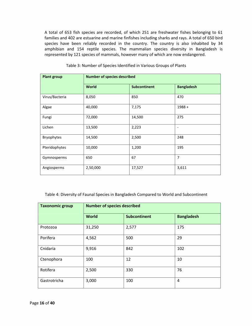
A total of 653 fish species are recorded, of which 251 are freshwater fishes belonging to 61 families and 402 are estuarine and marine finfishes including sharks and rays. A total of 650 bird species have been reliably recorded in the country. The country is also inhabited by 34 amphibian and 154 reptile species. The mammalian species diversity in Bangladesh is represented by 121 species of mammals, however many of which are now endangered.
Table 3: Number of Species Identified in Various Groups of Plants
Plant group Number of species described
World Subcontinent Bangladesh
Virus/Bacteria 8,050 850 470
Algae 40,000 7,175 1988 +
Fungi 72,000 14,500 275
Lichen 13,500 2,223 -
Bryophytes 14,500 2,500 248
Pteridophytes 10,000 1,200 195
Gymnosperms 650 67 7
Angiosperms 2,50,000 17,527 3,611
Table 4: Diversity of Faunal Species in Bangladesh Compared to World and Subcontinent
Taxonomic group Number of species described
World Subcontinent Bangladesh
Protozoa 31,250 2,577 175
Porifera 4,562 500 29
Cnidaria 9,916 842 102
Ctenophora 100 12 10
Rotifera 2,500 330 76
Gastrotricha 3,000 100 4
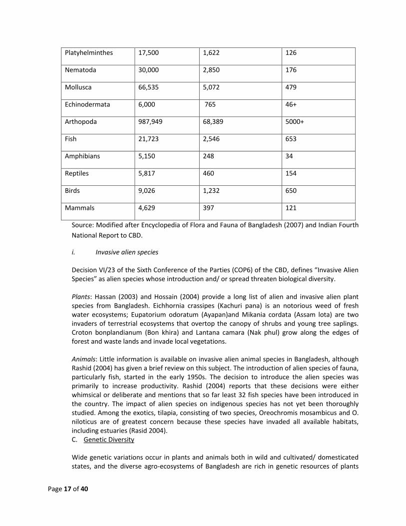
Page 17 of 40
Platyhelminthes 17,500 1,622 126
Nematoda 30,000 2,850 176
Mollusca 66,535 5,072 479
Echinodermata 6,000 765 46+
Arthopoda 987,949 68,389 5000+
Fish 21,723 2,546 653
Amphibians 5,150 248 34
Reptiles 5,817 460 154
Birds 9,026 1,232 650
Mammals 4,629 397 121
Source: Modified after Encyclopedia of Flora and Fauna of Bangladesh (2007) and Indian Fourth
National Report to CBD.
i. Invasive alien species Decision VI/23 of the Sixth Conference of the Parties (COP6) of the CBD, defines “Invasive Alien Species” as alien species whose introduction and/ or spread threaten biological diversity. Plants: Hassan (2003) and Hossain (2004) provide a long list of alien and invasive alien plant species from Bangladesh. Eichhornia crassipes (Kachuri pana) is an notorious weed of fresh water ecosystems; Eupatorium odoratum (Ayapan)and Mikania cordata (Assam lota) are two invaders of terrestrial ecosystems that overtop the canopy of shrubs and young tree saplings. Croton bonplandianum (Bon khira) and Lantana camara (Nak phul) grow along the edges of forest and waste lands and invade local vegetations. Animals: Little information is available on invasive alien animal species in Bangladesh, although Rashid (2004) has given a brief review on this subject. The introduction of alien species of fauna, particularly fish, started in the early 1950s. The decision to introduce the alien species was primarily to increase productivity. Rashid (2004) reports that these decisions were either whimsical or deliberate and mentions that so far least 32 fish species have been introduced in the country. The impact of alien species on indigenous species has not yet been thoroughly studied. Among the exotics, tilapia, consisting of two species, Oreochromis mosambicus and O. niloticus are of greatest concern because these species have invaded all available habitats, including estuaries (Rasid 2004). C. Genetic Diversity Wide genetic variations occur in plants and animals both in wild and cultivated/ domesticated states, and the diverse agro-ecosystems of Bangladesh are rich in genetic resources of plants
Page 18 of 40
and animals. Local communities have selected and conserved genetic variations in plants and animals in the various agro-ecological zones for centuries. More recently, there have been organized efforts in preserving the domesticated biodiversity by both governmental and non-governmental agencies, which have built up large germplasm collections. Domesticated plants in Bangladesh range from rice and millets to tubers such as Dioscorea (yam), Colocasia (taro), Ipomoea batatus (sweet potato), legumes, oil seeds, vegetables, fruits, spices and fiber (cotton and jute) (Haque, Mamtazul 2003). The greatest diversity in any crop is that which is known in rice (Oryza sativa). Six thousand varieties of rice are known to have existed in the country (Khan., 1997). (Also see NBSAP background materials by Hassan, 2003; Haque, 2003; Hossain, 2004; Yusuf, 2003). Domesticated animal biodiversity in Bangladesh is largely limited to livestock. To a very small extent, dogs, cats and ornamental fish contribute to the diversity. Other than these, there are domesticated pigs in the tribal settlements in the hills. A number of fish species are cultured throughout the country. Genetic variation within a species is what allows populations to adapt in changed habitat and other local environmental conditions. Bangladesh has rich genetic resources and diversity of most of its species. This is more evident of being centre of origin for some important agricultural crops. As an example, the floodplain of Bangladesh is thought to be the centre of origin of cultivated rice. An estimated 10,000 rice cultivars have been developed in the country. Bangladesh Rice Research Institute (BRRI) has so far collected 5,978 varieties of rice germplasms from the country. Most of the other cultivated crops have similar genetic diversity within themselves. This situation is also true for banana, mango and other local fruit species. Some 1,090 landraces of Dehsi jute (Corchorus capsularis) and 519 of Tossa jute (Corchorus olitorius) were reported to be scattered throughout Bangladesh, and there are 700 tea germplasm, 300 varieties of sugarcane, and so on. In the wild, the genetic diversity among the aquatic macrophytes found to be very high, this may be the cause of their resilience to cope in varying environmental conditions and hydrological regimes. Richness of genetic diversity in our medicinal plant species also worth mention here. An excellent and commercially valuable gene pool is present in the local chicken breeds. As a close relative to wildfowl they are highly resistant to most of the common diseases suffered by commercial breeds and as a consequence their gene pool is valuable for commercial exploitation. Genetic diversity of our freshwater fishes is also found to be very high. Among the Rhesus macaque population of Bangladesh, seven different genotypes have been identified (Feeroz et.al. 2008). Similar types of genetic variations are expected to be present in other primate populations in the country. Genetic diversity in Bengal Tiger and cetaceans are currently being investigated also. Present Status of Ecosystem Conservation There exists different ecosystem conservation efforts in Bangladesh which can be broadly classified as i) Protected area management under the forest department, ii) management of
Page 19 of 40
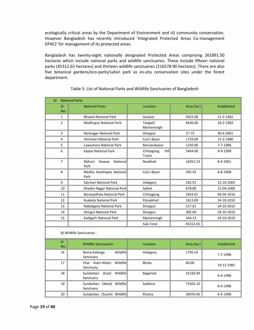
ecologically critical areas by the Department of Environment and iii) community conservation. However Bangladesh has recently introduced ‘Integrated Protected Areas Co-management (IPAC)’ for management of its protected areas. Bangladesh has twenty-eight nationally designated Protected Areas comprising 261891.50 hectares which include national parks and wildlife sanctuaries. These include fifteen national parks (45312.65 hectares) and thirteen wildlife sanctuaries (216578.90 hectares). There are also five botanical gardens/eco-parks/safari park as ex-situ conservation sites under the forest department.
Table 5: List of National Parks and Wildlife Sanctuaries of Bangladesh
A) National Parks
Sl. No.
National Parks Location Area (ha.) Established
1 Bhawal National Park Gazipur 5022.00 11-5-1982
2 Modhupur National Park Tangail/ Mymensingh
8436.00 24-2-1982
3 Ramsagar National Park Dinajpur 27.75 30-4-2001
4 Himchari National Park Cox's Bazar 1729.00 15-2-1980
5 Lawachara National Park Moulavibazar 1250.00 7-7-1996
6 Kaptai National Park Chittagong Hill Tracts
5464.00 9-9-1999
7 Nijhum Dweep National Park
Noakhali 16352.23 8-4-2001
8 Medha Kachhapia National Park
Cox's Bazar 395.92 8-8-2008
9 Satchari National Park Habigonj 242.91 15-10-2005
10 Khadim Nagar National Park Sylhet 678.80 13-04-2006
11 Baraiyadhala National Park Chittagong 2933.61 06-04-2010
12 Kuakata National Park Patuakhali 1613.00 24-10-2010
13 Nababgonj National Park Dinajpur 517.61 24-10-2010
14 Shingra National Park Dinajpur 305.69 24-10-2010
15 Kadigarh National Park Mymensingh 344.13 24-10-2010
Sub-Total 45312.65
B) Wildlife Sanctuaries :
Sl. No.
Wildlife Sanctuaries Location Area (ha.) Established
16 Rema-Kalenga Wildlife Sanctuary
Hobigonj 1795.54 7-7-1996
17 Char Kukri-Mukri Wildlife Sanctuary
Bhola 40.00 19-12-1981
18 Sundarban (East) Wildlife Sanctuary
Bagerhat 31226.94 6-4-1996
19 Sundarban (West) Wildlife Sanctuary
Satkhira 71502.10 6-4-1996
20 Sundarban (South) Wildlife Khulna 36970.45 6-4-1996
Page 20 of 40
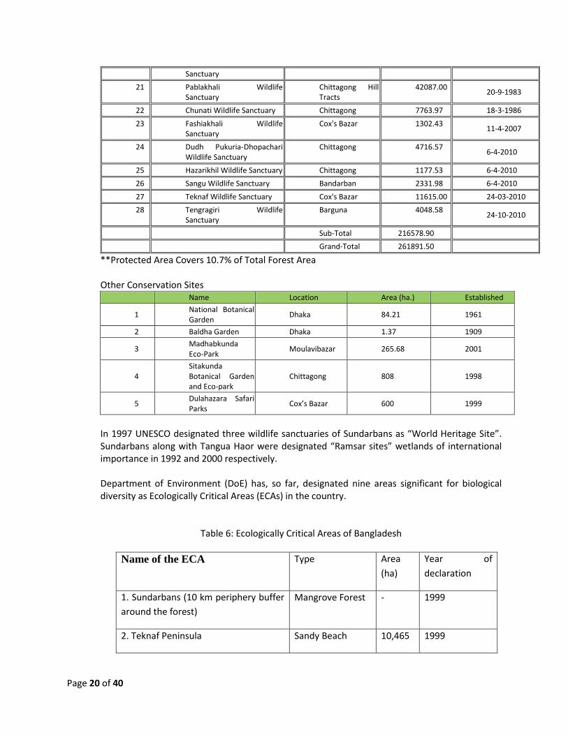
Sanctuary
21 Pablakhali Wildlife Sanctuary
Chittagong Hill Tracts
42087.00 20-9-1983
22 Chunati Wildlife Sanctuary Chittagong 7763.97 18-3-1986
23 Fashiakhali Wildlife Sanctuary
Cox's Bazar 1302.43 11-4-2007
24 Dudh Pukuria-Dhopachari Wildlife Sanctuary
Chittagong 4716.57 6-4-2010
25 Hazarikhil Wildlife Sanctuary Chittagong 1177.53 6-4-2010
26 Sangu Wildlife Sanctuary Bandarban 2331.98 6-4-2010
27 Teknaf Wildlife Sanctuary Cox's Bazar 11615.00 24-03-2010
28 Tengragiri Wildlife Sanctuary
Barguna 4048.58 24-10-2010
Sub-Total 216578.90
Grand-Total 261891.50
**Protected Area Covers 10.7% of Total Forest Area Other Conservation Sites
Name Location Area (ha.) Established
1 National Botanical Garden
Dhaka 84.21 1961
2 Baldha Garden Dhaka 1.37 1909
3 Madhabkunda Eco-Park
Moulavibazar 265.68 2001
4 Sitakunda Botanical Garden and Eco-park
Chittagong 808 1998
5 Dulahazara Safari Parks
Cox’s Bazar 600 1999
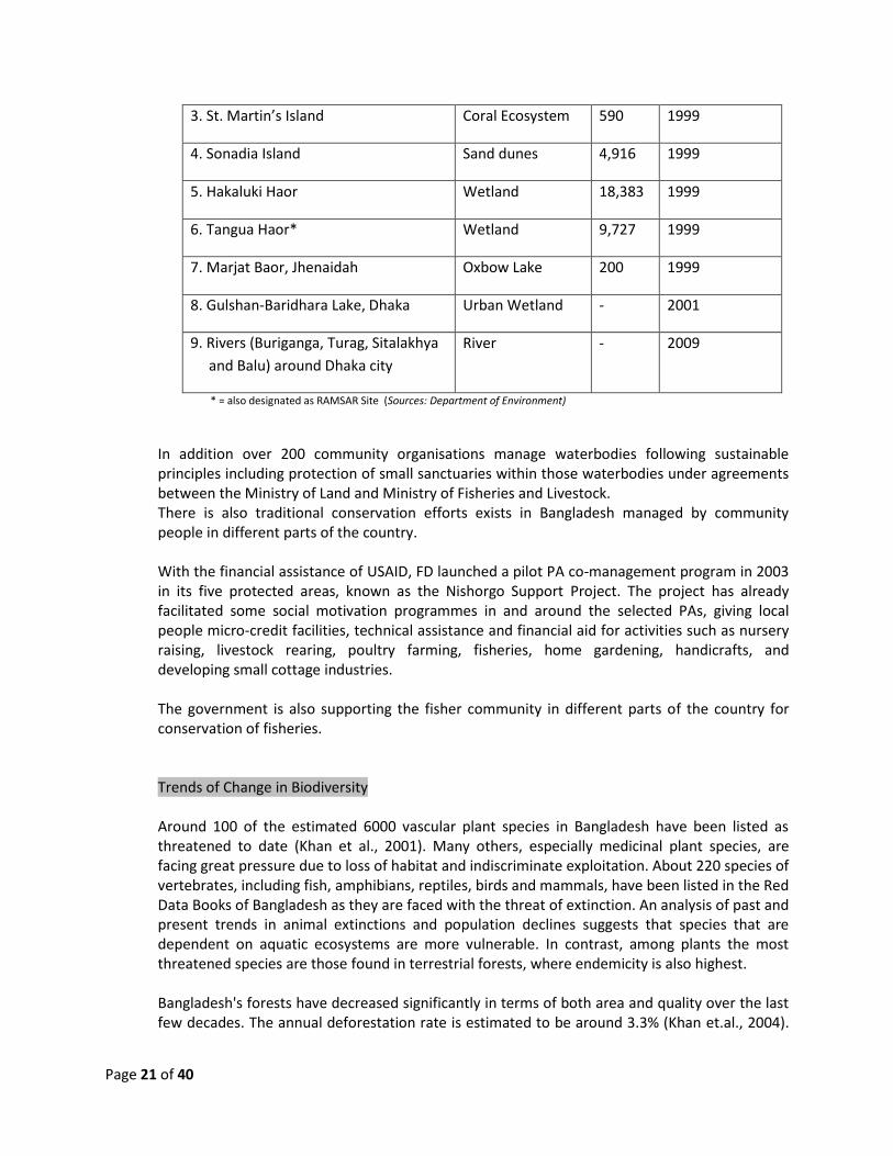
In 1997 UNESCO designated three wildlife sanctuaries of Sundarbans as “World Heritage Site”. Sundarbans along with Tangua Haor were designated “Ramsar sites” wetlands of international importance in 1992 and 2000 respectively. Department of Environment (DoE) has, so far, designated nine areas significant for biological diversity as Ecologically Critical Areas (ECAs) in the country.
Table 6: Ecologically Critical Areas of Bangladesh
Name of the ECA Type Area
(ha)
Year of
declaration
1. Sundarbans (10 km periphery buffer
around the forest)
Mangrove Forest - 1999
2. Teknaf Peninsula Sandy Beach 10,465 1999
Page 21 of 40
3. St. Martin’s Island Coral Ecosystem 590 1999
4. Sonadia Island Sand dunes 4,916 1999
5. Hakaluki Haor Wetland 18,383 1999
6. Tangua Haor* Wetland 9,727 1999
7. Marjat Baor, Jhenaidah Oxbow Lake 200 1999
8. Gulshan-Baridhara Lake, Dhaka Urban Wetland - 2001
9. Rivers (Buriganga, Turag, Sitalakhya
and Balu) around Dhaka city
River - 2009
* = also designated as RAMSAR Site (Sources: Department of Environment)
In addition over 200 community organisations manage waterbodies following sustainable principles including protection of small sanctuaries within those waterbodies under agreements between the Ministry of Land and Ministry of Fisheries and Livestock. There is also traditional conservation efforts exists in Bangladesh managed by community people in different parts of the country. With the financial assistance of USAID, FD launched a pilot PA co-management program in 2003 in its five protected areas, known as the Nishorgo Support Project. The project has already facilitated some social motivation programmes in and around the selected PAs, giving local people micro-credit facilities, technical assistance and financial aid for activities such as nursery raising, livestock rearing, poultry farming, fisheries, home gardening, handicrafts, and developing small cottage industries. The government is also supporting the fisher community in different parts of the country for conservation of fisheries. Trends of Change in Biodiversity Around 100 of the estimated 6000 vascular plant species in Bangladesh have been listed as threatened to date (Khan et al., 2001). Many others, especially medicinal plant species, are facing great pressure due to loss of habitat and indiscriminate exploitation. About 220 species of vertebrates, including fish, amphibians, reptiles, birds and mammals, have been listed in the Red Data Books of Bangladesh as they are faced with the threat of extinction. An analysis of past and present trends in animal extinctions and population declines suggests that species that are dependent on aquatic ecosystems are more vulnerable. In contrast, among plants the most threatened species are those found in terrestrial forests, where endemicity is also highest. Bangladesh's forests have decreased significantly in terms of both area and quality over the last few decades. The annual deforestation rate is estimated to be around 3.3% (Khan et.al., 2004).
Page 22 of 40
The increasing population of Bangladesh continues to put pressure on existing forest resources resulting in over exploitations. Present productivity of forest has declined to a range of 1.5-2.5 m per hectare per annum from 7-8 m per hectare per annum that was accounted twenty years ago (Forestry Master Plan, 1993). Moreover, canopy closure density, number of trees per hectare and over all plant biodiversity has declined rapidly (FAO, 2000). As a consequence, the quality of the forestland as wildlife habitat has also been reduced. Over the last three decades, massive physical infrastructures in the form of rural road and flood embankments have been developed in the wetlands including floodplains and haor areas. Many of these infrastructures have disregarded local topographic condition and natural water flow direction, which have often resulted in loss of connectivity, enhanced drainage and reclamation of wetlands, and in other areas waterlogging; all have affected the local surface water regime. The critical point of such development activities in the wetlands led the transformation very rapidly at a massive scale. In the Ganges-Brahmaputra floodplain area, about 2.1 million hectares of wetland have been lost to Flood Control, Drainage and Irrigation development projects (FCDI). Human interference in the wetlands has been damaging the fragile ecosystem and to long-term sustainability of the wetlands. For instance, in the southwest brackish water coastal plains of Bangladesh farmers used to have a single paddy crop during monsoon when surface saline layer depletes due to heavy rainfall and for rest of the months the fields were left for grazing. The practice of this culture evolved and was enriched by local knowledge for centuries. However, in the last two decades, this entire practice has been abandoned to provide space for more profitable shrimp farming. As a result, local ecosystems changed because of changed water exchange system, rapid siltation of the channels and continuous inundation of land with saline water. In the haor areas, large scale settlement was initiated at the mid-20th century from surrounding densely populated regions and since then the resources of the haor basins are being exploited at Continuous exploitation of aquatic vegetation and fruits like Makna (Euryale ferox), Singara (Trapa bispinosa ), Lotus, Waterlily, Hogla (Typha elephantina) has caused serious degradation of the quantity and quality of the habitat required for fish and migratory birds in the haor areas. Similarly, embankment constructed for FCDI projects reduced floodplains and made obstacles to fish movement and migration from rivers as well as beels to the remaining floodplains for feeding and breeding. As a result, many fishers have lost their livelihood. As a whole, degradation of wetlands has caused several problems including extinction and reduction of wildlife, extinction of many indigenous wild and domesticated rice varieties, loss of many indigenous aquatic plants, herbs, shrubs and weeds, loss of natural soil nutrients, loss of natural water reservoirs and of their resultant benefits, increase in the occurrence of flooding and degeneration of wetland based ecosystems, occupations, socio-economic institutions and cultures. However, some noteworthy endeavors can be mentioned both from government and NGO sectors in restoration of wetland habitat in the country. CWBMP has been working in several inland and coastal wetlands to protect biodiversity thereof involving local communities. MACH was another project where ecosystem protection approach was used to conserve the habitat and its resources. CBRMP programme of LGED is also working on fisheries restoration and resource management.
Page 23 of 40
The area of settlement and consequently homestead vegetation is growing gradually for the last few decades with population growth, resulting in loss of other ecosystems. However, tree density of the homesteads has increased in the recent past. A comparison between the first village forest assessment conducted in 1981 (Hammermaster, 1981) and the recently conducted national forest and tree resources assessment 2005-2007 have shown this increase up to 300% in volume in certain parts of the country. However, the quality of the homestead ecosystem has declined rapidly, because of the commercialization of the land. Species diversity reduces drastically with rapid increase of commercially valuable species. Loss of plant species diversity also reduces the quality of wildlife habitat by reducing food sources and other microhabitats essential for supporting the integrity of the food chain. The coastal zone including the world's largest stretch of mangrove ecosystem, the Sundarbans (declared as Ramsar Site in 1997), is facing a serious threat of loss of biodiversity due to change in climate. Other issues of ecosystem health that are common throughout the coast are: environmental stresses on the Bay of Bengal's water quality; the degradation of many of the coral, mangrove, wetland and seagrass bed habitats that support fisheries; and the use of fishing gear that may affect the long-term sustainability of the fisheries resources. Northward penetration of the salinity front due to climate change would result in further salinity induced succession problems in the Sundarbans and as a result, the symbiotic process in the entire ecosystem would change completely. Since the rate of these changes are much higher compared to the rates at which forest species migrate to suitable places, the size of the (actual) forest will be less compared to its present size. The major rivers bring in large concentrations of pollutants from agricultural pesticides and industrial waste that damage fish spawning and nursery areas, cause death of fishes and lead to possible changes in trophic structure. High levels of pesticides can be found along the coast, especially near cities and ports. Input of freshwater from upstream and silt influence the pollutant dilution and salinity of the coastal and estuarine waters as well as coastal circulation patterns. It is also seriously threatening the existence of the corals at their one site in the country. Moreover pollutants from the substantial and largely unregulated ship-breaking industry pose an unquantified hazard to coastal and marine life. Development in the coastal zone is set to continue to threaten ecosystems and biodiversity. The rapid growth of the domestic tourism industry has harmful impacts in St Martin's Island and Cox's Bazar including collection of shells and corals. A deep water port has recently been proposed for Sonadia Island ECA, one of the very few coastal protected areas and main site of wintering Spon-billed Sandpipers. More generally the huge population burden and associated poverty, unsustainable fishing practices and a decline in income from fisheries are contributing to crisis generation. Other activities like tourism, collection of sand and stone is also hampering the marine environment. Recent research findings have indicated a rising trend of imbalance and indiscriminate use of agricultural inputs, which has already created a threat to the proper functioning of the country's agroecosystems. Land degradation due to over utilization, landuse change and construction of various man-made infrastructures has aggravated this situation in most of the agroecological regions of the country. Moreover, with the ensuing threat of climatic change, existing agroecosystems of the country could be under heavy pressure to feed the population. For a small country like Bangladesh, the species richness is relatively large but population size of most of the species are gradually declining. Twenty three species of globally threatened mammals, birds and reptiles are so far extinct from Bangladesh. Bangladesh National Herbarium

Page 24 of 40
(2001) published a Red Data Book of Vascular Plants of Bangladesh listing 106 species of threatened plant species of various categories. Table 7: National Status of Inland and Resident Vertebrates of Bangladesh (IUCN, 2000; Siddiqui
et al 2008)
Table 8: List of animal species extinct from Bangladesh in the last century
Source: Hafeez, et. Al. 2008
Genetic diversity of different crops and cereals are declining sharply. In the name of green revolution, new high yielding varieties are introduced from early seventies. Out of thousands of rice varieties, the farmers now commonly use only about 25 varieties. Similar kind of declining trend has been occurred in other cultivated crop varieties as well. Reduction in number of species and decline of wild flora and fauna is also a common trend like elsewhere in the world. For wild flora and fauna declining trend is mostly attributed to habitat loss. Fragmentation of forest and other natural areas caused great loss of species diversity as well as its genetic resources. Reduction of population size, and fragmentation of habitat forced the wildlife to inbreed, causing genetic erosion.
Page 25 of 40
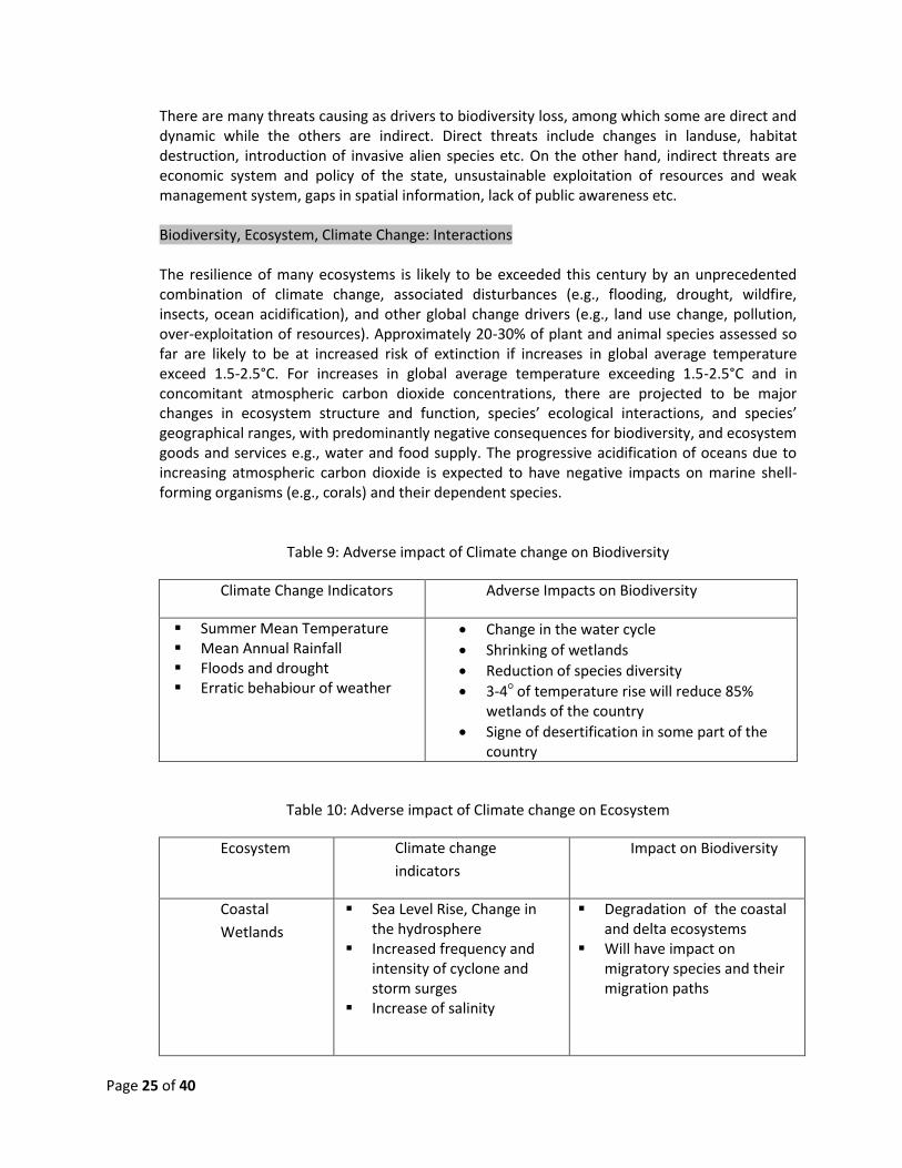
There are many threats causing as drivers to biodiversity loss, among which some are direct and dynamic while the others are indirect. Direct threats include changes in landuse, habitat destruction, introduction of invasive alien species etc. On the other hand, indirect threats are economic system and policy of the state, unsustainable exploitation of resources and weak management system, gaps in spatial information, lack of public awareness etc. Biodiversity, Ecosystem, Climate Change: Interactions The resilience of many ecosystems is likely to be exceeded this century by an unprecedented combination of climate change, associated disturbances (e.g., flooding, drought, wildfire, insects, ocean acidification), and other global change drivers (e.g., land use change, pollution, over-exploitation of resources). Approximately 20-30% of plant and animal species assessed so far are likely to be at increased risk of extinction if increases in global average temperature exceed 1.5-2.5°C. For increases in global average temperature exceeding 1.5-2.5°C and in concomitant atmospheric carbon dioxide concentrations, there are projected to be major changes in ecosystem structure and function, species’ ecological interactions, and species’ geographical ranges, with predominantly negative consequences for biodiversity, and ecosystem goods and services e.g., water and food supply. The progressive acidification of oceans due to increasing atmospheric carbon dioxide is expected to have negative impacts on marine shell-forming organisms (e.g., corals) and their dependent species.
Table 9: Adverse impact of Climate change on Biodiversity
Climate Change Indicators Adverse Impacts on Biodiversity
Summer Mean Temperature Mean Annual Rainfall Floods and drought Erratic behabiour of weather
Change in the water cycle
Shrinking of wetlands
Reduction of species diversity
3-4○ of temperature rise will reduce 85% wetlands of the country
Signe of desertification in some part of the country
Table 10: Adverse impact of Climate change on Ecosystem
Ecosystem Climate change
indicators
Impact on Biodiversity
Coastal
Wetlands
Sea Level Rise, Change in the hydrosphere
Increased frequency and intensity of cyclone and storm surges
Increase of salinity
Degradation of the coastal and delta ecosystems
Will have impact on migratory species and their migration paths

Page 26 of 40
Forests Changes in precipitation, evapotranspiration and temperature
Cyclone, Storm Surges and fire
Changes in sunshine hours and cloud cover
There will be massive change in forest species
Some forests will disappear Forest dependent species
will face extinction
Low Islands /
Chars
Sea Level Rise Increased frequency and
intensity of cyclone and storm surges
Decrease of landmass Decrease of habitat and food
sources for marine birds Increased population
pressure on narrow land
Coral reef Sea surface temperature Acidification of sea water
due to condensation of CO2
Long term increase of temperature (even 1○ C increase) will cause coral bleaching.
Increased acidification of sea water will intensify coral bleaching and disrupt coral reef formation process
Mangrove Sea Level Rise and imbalance in the coastal hydrology
Increase intensity and frequency of cyclone and storm surges
Inundation of coastal lands Shrinking of coastal
ecosystem Decrease mangrove
dependent species and their food availability
Floodplain Mean summer temperature Amount and duration of
rainfall River flow Rate of evaporation
Reduced habitat Reduced biodiversity Reduced production will
hamper food safety
Biodiversity Management in Bangladesh: Milestones Bangladesh has signed the five major conventions and agreements related to biodiversity conservation (i.e., CBD, CITES, CMS, RAMSAR, WHC) (Brown and Durst, 2003). As a signatory party of these conventions the government has undertaken various initiatives to conserve the biodiversity in both ecosystem and species level. Again as a CBD-COP the country is bound to adopt the Ecosystem Approach to conserve biodiversity. The government of Bangladesh is committed to conserve its natural resources through a series of international treaties, conventions and also by its constitution. These have been reflected through the documents approved by the government and the Parliament, and by the commitments made by the Prime Minister in various international forums.
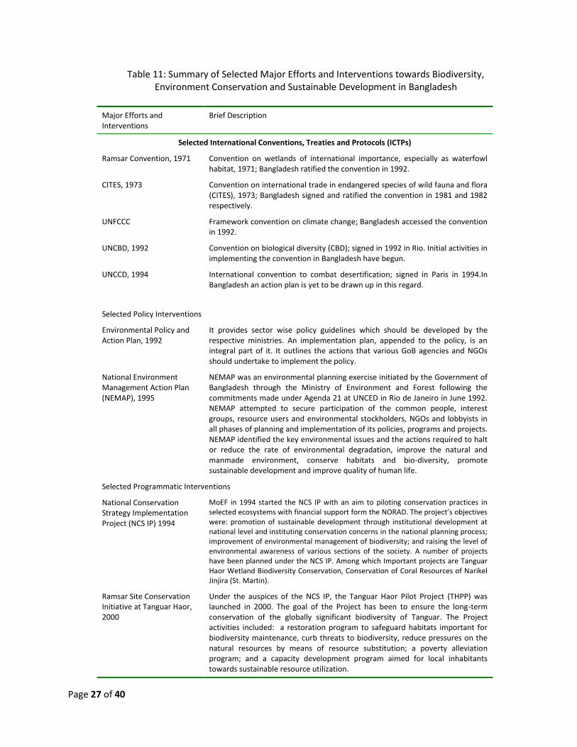
Page 27 of 40
Table 11: Summary of Selected Major Efforts and Interventions towards Biodiversity, Environment Conservation and Sustainable Development in Bangladesh
Major Efforts and Interventions
Brief Description
Selected International Conventions, Treaties and Protocols (ICTPs)
Ramsar Convention, 1971 Convention on wetlands of international importance, especially as waterfowl habitat, 1971; Bangladesh ratified the convention in 1992.
CITES, 1973 Convention on international trade in endangered species of wild fauna and flora (CITES), 1973; Bangladesh signed and ratified the convention in 1981 and 1982 respectively.
UNFCCC Framework convention on climate change; Bangladesh accessed the convention in 1992.
UNCBD, 1992 Convention on biological diversity (CBD); signed in 1992 in Rio. Initial activities in implementing the convention in Bangladesh have begun.
UNCCD, 1994 International convention to combat desertification; signed in Paris in 1994.In Bangladesh an action plan is yet to be drawn up in this regard.
Selected Policy Interventions
Environmental Policy and Action Plan, 1992
It provides sector wise policy guidelines which should be developed by the respective ministries. An implementation plan, appended to the policy, is an integral part of it. It outlines the actions that various GoB agencies and NGOs should undertake to implement the policy.
National Environment Management Action Plan (NEMAP), 1995
NEMAP was an environmental planning exercise initiated by the Government of Bangladesh through the Ministry of Environment and Forest following the commitments made under Agenda 21 at UNCED in Rio de Janeiro in June 1992. NEMAP attempted to secure participation of the common people, interest groups, resource users and environmental stockholders, NGOs and lobbyists in all phases of planning and implementation of its policies, programs and projects. NEMAP identified the key environmental issues and the actions required to halt or reduce the rate of environmental degradation, improve the natural and manmade environment, conserve habitats and bio-diversity, promote sustainable development and improve quality of human life.
Selected Programmatic Interventions
National Conservation Strategy Implementation Project (NCS IP) 1994
MoEF in 1994 started the NCS IP with an aim to piloting conservation practices in selected ecosystems with financial support form the NORAD. The project’s objectives were: promotion of sustainable development through institutional development at national level and instituting conservation concerns in the national planning process; improvement of environmental management of biodiversity; and raising the level of environmental awareness of various sections of the society. A number of projects have been planned under the NCS IP. Among which Important projects are Tanguar Haor Wetland Biodiversity Conservation, Conservation of Coral Resources of Narikel Jinjira (St. Martin).
Ramsar Site Conservation Initiative at Tanguar Haor, 2000
Under the auspices of the NCS IP, the Tanguar Haor Pilot Project (THPP) was launched in 2000. The goal of the Project has been to ensure the long-term conservation of the globally significant biodiversity of Tanguar. The Project activities included: a restoration program to safeguard habitats important for biodiversity maintenance, curb threats to biodiversity, reduce pressures on the natural resources by means of resource substitution; a poverty alleviation program; and a capacity development program aimed for local inhabitants towards sustainable resource utilization.
Page 28 of 40
Major Efforts and Interventions
Brief Description
Legal Mechanism for Environmental Protection
Environmental Conservation Act (ECA) 1995 and Environmental Conservation Rules (ECR) 1997
The first major law that has been promulgated for the specific purpose of conservation of nature and protection of environment is the Environmental Conservation Act (ECA) of 1995, which was followed by the Environmental Conservation Rules (ECR) of 1997.
Environmental Court Act, 2000
The act provides for the establishment of one or more Environmental Courts, primarily at each Divisions of the country, with specific terms of references to deal with environmental offences.
5. National Road Map
The Convention on Biological Diversity (CBD) in its Sixth Conference of Parties in The Hague, Netherlands, in April 2002 resolved to reduce significantly biodiversity loss by 2010 at the global, regional and national levels in an effort to alleviate poverty and benefit the Earth (CBD 2002). Although the 2010 targets of the CBD were not fully met, the premise of the targets remain fundamentally solid. In 10th Conference of the Parties of CBD held in 2010 at Nagoya, the targets were reiterated with more emphasis on achieving them over the next ten years. Being all the countries in the Eastern Himalayas are party to the CBD national roadmap of each party should be in the line with fulfilling 2020 strategic targets. Bangladesh being a part of Eastern Himalayas and highly influenced by the glacier-fed rivers originating in the Himalaya mountain ranges drains the largest river run-off from any single location in the world. Being a low-riparian country in the EH region the contribution of biodiversity and ecosystem services for Bangladesh depend on the rivers and wetlands of EH and to sustain the country’s ecosystem. So, the roadmap for Bangladesh cannot be furnished without the consideration of regional issues of EH. The majority of threats to biodiversity in the EH are linked to human population growth and economic development, and the corresponding increasing demand for natural resources and space. The major threats to biodiversity are habitat degradation, pollution, over-exploitation, alien species invasion and river flow modification. Bangladesh has developed National Biodiversity Strategy and Action Plan in 2006 as per its obligation as a party to the CBD. NBSAP considers climate change as one of the major risks to uphold its targets and to implement action plans. The consequences of climate change like temperature increase, erratic rainfall, occurrence of cyclone, saline water intrusion in the coastal areas, incidence of drought is a major cause for destruction of habitats of species and at the same time undermine production and the thriving nature of agricultural biodiversity, which might bring instability in food security of the people of Bangladesh. In this context, National Adaptation Plan of Action (NAPA) and Bangladesh Climate Change Strategy and Action Plan (BCCSAP), developed by the Government of Bangladesh, identified areas where specific programmes could be implemented in order to reduce the climate change threats to
Page 29 of 40
biodiversity. The NAPA lists a number of programmes based on some criteria, among which some are attuned with CBD principles. For example, NAPA recommended promotion of coastal afforestation through community participation to reduce the threats of climate change under its intervention type measures. In addition, some of the propositions (proposed by NAPA and BCCSAP) include development of plant/crop varieties, which are tolerant to changing climatic conditions, some focused on institutional capacity building issues so that institutions become skilled and ready to act to reduce the climate change induced threats. The proposed plans (i.e. both NBSAP and BCCSAP) have common and coinciding areas. Sometimes, it is difficult to find explicit correlation among the elements of these two plans, although in many respects they have indirect impacts on others. However, better management of different ecosystems will be taking place if capacity building of different agencies is ensured through implementation of BCCSAP. It is important to understand the linkages between the NBSAP and Poverty Reduction Strategy Paper (PRSP). Both the Poverty Strategy Papers, i.e. PRSP I (2007-2008) and the NSAPR (2009-2011) take into account aspects of environmental health, energy, agriculture, natural resources, climate change and disaster management. Especially the NSAPR explicitly asserted to protect and tackle climate change to ensure sustainable development. The strategy papers also address forestry and fisheries issues. NSAPR proposed to reverse the downward spiral of poverty and environmental degradation considering the fact that the underlying causes of biodiversity loss are linked to the causes of poverty. However, improving ecosystem health and at the same time reducing poverty requires pooling of local knowledge and experiences and mainstreaming the biodiversity concerns into all sectoral development strategies.
6. Regional Issues and Concerns of Biodiversity Conservation
Ensuring regional interconnectivity of the ecological processes is critical for biodiversity conservation to ensure its goods and services for human wellbeing. The regional issues and concerns such as, pollutions, habitat loss, deforestation, illegal wildlife trading, upstream withdrawal of water etc. are very critical for biodiversity conservation at a regional scale. Therefore, common understanding and coordinated effort from the Eastern Himalayas countries are essential to establish connectivity in the ecosystems. The following broad strategic actions are very important for Eastern Himalayas region to ensure biodiversity conservation which is essential for sustainable development.
I. Ensure environmental flow to maintain ecological process II. Minimize transboundary pollution from agricultural run-off and industrial sources
III. Establish biological corridor IV. Control and protection of invasive and alien species V. Establishing a harmonized system for accessing to and sharing of genetic resources and
associated traditional knowledge VI. Knowledge management and information sharing
Page 30 of 40
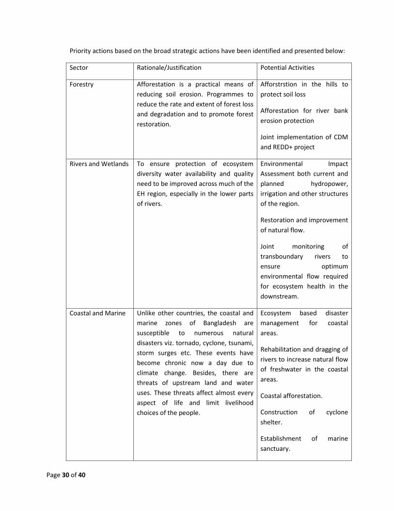
Priority actions based on the broad strategic actions have been identified and presented below:
Sector Rationale/Justification Potential Activities
Forestry Afforestation is a practical means of
reducing soil erosion. Programmes to
reduce the rate and extent of forest loss
and degradation and to promote forest
restoration.
Afforstrstion in the hills to
protect soil loss
Afforestation for river bank
erosion protection
Joint implementation of CDM
and REDD+ project
Rivers and Wetlands To ensure protection of ecosystem
diversity water availability and quality
need to be improved across much of the
EH region, especially in the lower parts
of rivers.
Environmental Impact
Assessment both current and
planned hydropower,
irrigation and other structures
of the region.
Restoration and improvement
of natural flow.
Joint monitoring of
transboundary rivers to
ensure optimum
environmental flow required
for ecosystem health in the
downstream.
Coastal and Marine Unlike other countries, the coastal and
marine zones of Bangladesh are
susceptible to numerous natural
disasters viz. tornado, cyclone, tsunami,
storm surges etc. These events have
become chronic now a day due to
climate change. Besides, there are
threats of upstream land and water
uses. These threats affect almost every
aspect of life and limit livelihood
choices of the people.
Ecosystem based disaster
management for coastal
areas.
Rehabilitation and dragging of
rivers to increase natural flow
of freshwater in the coastal
areas.
Coastal afforestation.
Construction of cyclone
shelter.
Establishment of marine
sanctuary.

Page 31 of 40
Mangrove The Sundarbans is of global importance
as the largest mangrove forest in the
world which has been declared as
UNESCO Heritage Site as well as
RAMSAR Site. Conservation of forest as
well as its biodiversity is quite important
for the protection of our coastal areas
as well as livelihood for a million
populations.
Joint project on Sundarbans
(India-Bangladesh)
conservation
Conservation programme for
protection of Bengal Tiger
Conservation There is a need for conservation and
documentation of genetic resources for
present and future use.
Transboundary protected
Areas management
Conservation of genetic
resources.
Establishment of regional
gene bank for crop and
livestock.
Establish regional monitoring
system.
Ensure free flow and natural
migration (trans-boundary) of
the wild animals.
Identification of regionally
common vulnerable species
and ensure protection.
Joint project for species conservation (i.e. Gharial, dolphin, tiger, elephant, migratory birds).
Assessment of Alien and
invasive species and their
impact on biodiversity.
Pollution Control Upstream pollution causes habitat and
biodiversity losses.
Promote environmental flow
in the EH region to maintain
ecological processes
Assessment of Transboundary
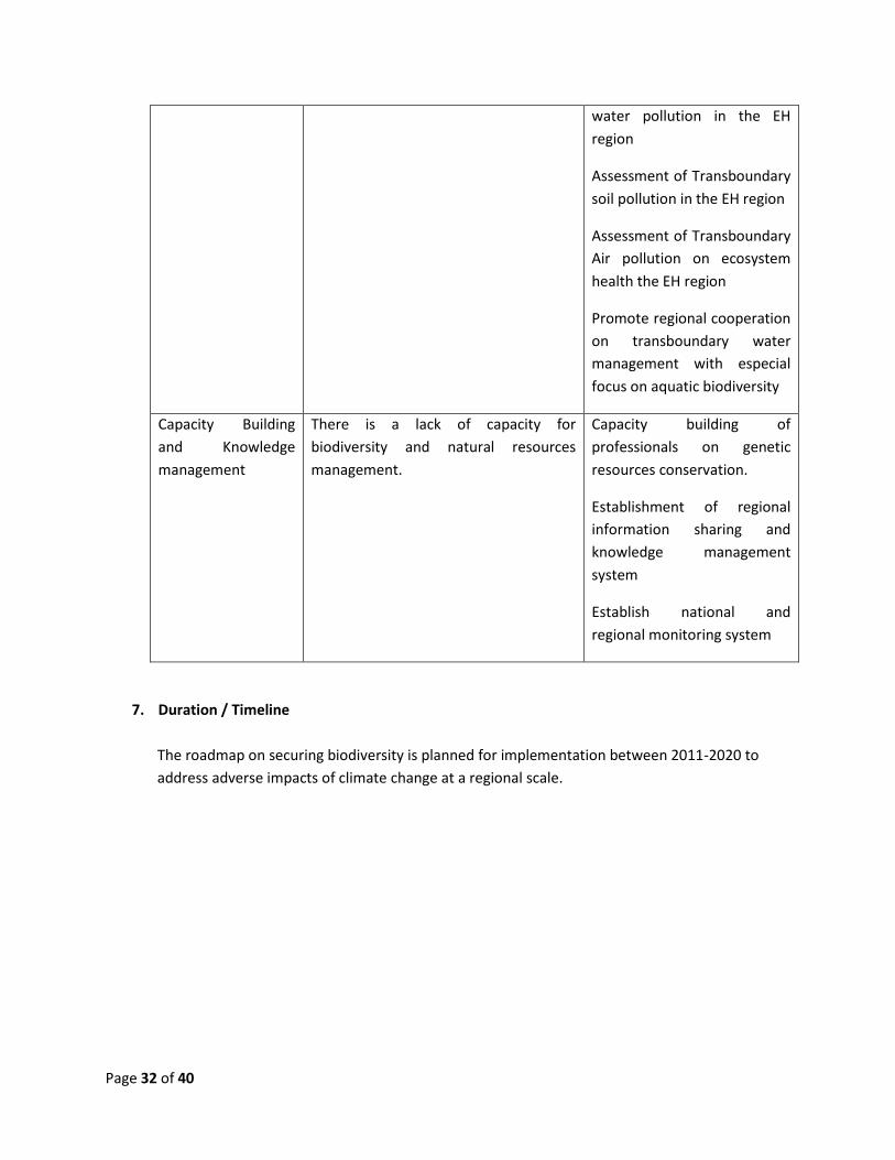
Page 32 of 40
water pollution in the EH
region
Assessment of Transboundary
soil pollution in the EH region
Assessment of Transboundary
Air pollution on ecosystem
health the EH region
Promote regional cooperation
on transboundary water
management with especial
focus on aquatic biodiversity
Capacity Building
and Knowledge
management
There is a lack of capacity for
biodiversity and natural resources
management.
Capacity building of
professionals on genetic
resources conservation.
Establishment of regional
information sharing and
knowledge management
system
Establish national and
regional monitoring system
7. Duration / Timeline
The roadmap on securing biodiversity is planned for implementation between 2011-2020 to
address adverse impacts of climate change at a regional scale.

Page 33 of 40
8. Priority Action Plan
Considering the impact of climate change following priority interventions will be undertaken at
national level.
Projects Phase of Implementation Indicative
resource
requirement in
million BDT 20
11
20
12
20
13
20
14
20
15
20
16
20
17
20
18
20
19
20
20
Project 1: Collection and conservation of local improved cultivars, characterization and their documentation
200.00
Project 2: Research to develop climate resilient varieties of rice (i.e. heat, drought, salinity and submergence tolerant varieties)
350.00
Project 3: Research to develop climate resilient (i.e. heat, drought, salinity and submergence tolerant varieties) cultivars of wheat and other food and non food crops including vegetables
400.00
Project 4: Develop climate resilient cropping patterns suited to different regions of the country
400.00
Project 5: Assess potential threats to fish spawning and growth of fish in fresh water, brackish water and coastal zone
50.00
Project 6: Assess potential threats to marine fish, shrimp, Hilsa fish and fish migration
50.00
Project 7: Assess potential threats to livestock and poultry sector
50.00
Project 8: Set up a well designed monitoring system to evaluate changes in ecosystem and biodiversity covering all important and sensitive ecosystems
100.00
Project 9: Report changes in ecosystem and biodiversity and assess the implications including those for the livelihoods of the local people
50.00
Project 10: Develop an extensive wetland afforestation programme including coastal afforestation
400.00
Project 11: Research the suitability of various tree species for their carbon locking properties for designing various forestry programmes
50.00
Project 12: Expand VGD facilities for the fisher of different char lands and conserve water bodies and biodiversity (Jatka Hilsa conservation)
500.00
Beside national project priorities, biodiversity roadmap needs to integrate regional efforts for sustainability. Livelihoods of the population in the countries of Eastern Himalayas including Bangladesh are largely dependent on biodiversity. Being a lower riparian country Bangladesh is largely dependent on the environmental flow of the region to maintain ecological process for producing ecological services and livelihood support to the natural resource depended population of the country.
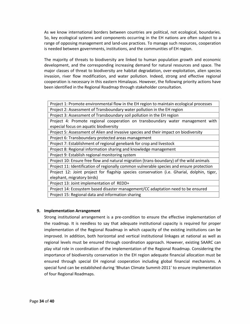
Page 34 of 40
As we know international borders between countries are political, not ecological, boundaries. So, key ecological systems and components occurring in the EH nations are often subject to a range of opposing management and land-use practices. To manage such resources, cooperation is needed between governments, institutions, and the communities of EH region. The majority of threats to biodiversity are linked to human population growth and economic development, and the corresponding increasing demand for natural resources and space. The major classes of threat to biodiversity are habitat degradation, over-exploitation, alien species invasion, river flow modification, and water pollution. Indeed, strong and effective regional cooperation is necessary in this eastern Himalayas. However, the following priority actions have been identified in the Regional Roadmap through stakeholder consultation.
Project 1: Promote environmental flow in the EH region to maintain ecological processes
Project 2: Assessment of Transboundary water pollution in the EH region
Project 3: Assessment of Transboundary soil pollution in the EH region
Project 4: Promote regional cooperation on transboundary water management with especial focus on aquatic biodiversity
Project 5: Assessment of Alien and invasive species and their impact on biodiversity
Project 6: Transboundary protected areas management
Project 7: Establishment of regional genebank for crop and livestock
Project 8: Regional information sharing and knowledge management
Project 9: Establish regional monitoring system
Project 10: Ensure free flow and natural migration (trans-boundary) of the wild animals
Project 11: Identification of regionally common vulnerable species and ensure protection
Project 12: Joint project for flagship species conservation (i.e. Gharial, dolphin, tiger, elephant, migratory birds)
Project 13: Joint implementation of REDD+
Project 14: Ecosystem based disaster management/CC adaptation need to be ensured
Project 15: Regional data and information sharing
9. Implementation Arrangement
Strong institutional arrangement is a pre-condition to ensure the effective implementation of
the roadmap. It is needless to say that adequate institutional capacity is required for proper
implementation of the Regional Roadmap in which capacity of the existing institutions can be
improved. In addition, both horizontal and vertical institutional linkages at national as well as
regional levels must be ensured through coordination approach. However, existing SAARC can
play vital role in coordination of the implementation of the Regional Roadmap. Considering the
importance of biodiversity conservation in the EH region adequate financial allocation must be
ensured through special EH regional cooperation including global financial mechanisms. A
special fund can be established during ‘Bhutan Climate Summit-2011’ to ensure implementation
of four Regional Roadmaps.
Page 35 of 40
9.1. Institutional Arrangement
The Ministry of Environment and Forests (MOEF) is the lead agency for implementing the
National Biodiversity Roadmap. As biodiversity is a cross-sectoral issue, other ministries also
have roles and responsibilities in implementing the roadmap. The roadmap will follow the
specific agencies role as mentioned in the NBSAP. However, Bhutan Climate Summit-2011
should establish accepted regional institutional mechanisms to implement Regional
Roadmap. This important issues can be discussed at length in the regional workshop to
develop agreed institutional arrangement at the regional level.
9.2. Financial Mechanism towards implementation of the Road Map
Broader implementation of the roadmap for conserving biodiversity in the Eastern Himalayas will be dependent on the initiatives of the respective governments in the region. Bangladesh is urging to establish a Regional Biodiversity trust fund to support emerging conservation initiatives. Yet, the respective country level effort towards mainstreaming biodiversity conservation in the development planning would be essential for achieving long term benefits. In the present context, biodiversity conservation initiatives in Bangladesh are financed mainly from budgets of the government agencies (especially through the Ministry of Environment and Forests), and through donor funding, NGO support and some contributions from the civil society.
However, the government of Bangladesh has made dramatic progress in resource allocation to address climate change impacts in the country. The Bangladesh Climate Change Trust Fund (BCCTF) was established in 2009 under the Ministry of Environment and Forests from contribution of revenue budget. The BCCTF received US$ 200 million in the financial 2009-2010 and 2010-2011 to address impacts of climate change through implementing development projects. This fund is being used for implementing the Bangladesh Climate Change Strategy and Action Plan in which important programs have been identified to address climate change impacts. More than fifty projects are being implanted through the BCCTF.
In addition, the Bangladesh Climate Change Resilience Fund (BCCRF) was also established
through partnership with development partners to mobilize global resources. The BCCRF
received US$ 125 million from United Kingdom, European Union, Sweden, Denmark and
Switzerland for BCCSAP implementation. The BCCRF can be used as effective institutional
mechanism for mobilizing global resources that has been committed by developed countries
under the UNFCCC process such as Fast Start Fund and Green Climate Fund.
Page 36 of 40
10. Monitoring and Review
For the successful implementation of the Biodiversity Roadmap, an effective and efficient monitoring and reporting system has to be in place. Monitoring and review of Biodiversity Roadmap would be a part of obligation for Bangladesh under Article 26 of the CBD and also for other EH region countries. Conceptually, the Monitoring and Reporting will involve:
Collection of information about the status of biodiversity and implementation of Roadmap priority activities by different implementing institutions and organizations and
Reporting periodically on the Convention issues to implementing bodies and the public in general There should be a common regional monitoring system for the Eastern Himalayans countries. Respective government of the countries would decide the ministry/institution/department exclusively for this purpose. Regarding implementation performance, the monitoring and review system will start by looking at the activities and projects implemented by the different organizations and institutions on the basis of their reports deposited with the relevant authorities. Regarding biodiversity status and trends, the M&R system will:
begin by preparing a Biodiversity Status Baseline Report, including performance indicators, to be taken as the reference point for future comparisons
collect secondary information and commission of scientific studies on a regular basis to assess the status and trends of key specific issues relevant to the Biodiversity Roadmap
conduct a new Biodiversity Status Report every five years, the results of which are going to be compared with the baseline ones in order to find the different trends affecting the different areas and issues relevant to biodiversity

Page 37 of 40
References:
Balakrishna Pisupati and Emilie Warner 2003. Biodiversity and Millennium Development Goals. IUCN Regional Biodiversity Programme, Asia, Colombo, Sri Lanka.
Constanza, R., d’Arge, R., de Groot, R., Fabes, S., Grano, M., Hannon, B., Limburg, K., Naeem, S.,
O’Neil, R. V., Pareulo ,J., Raskin, R., Sulton, P. and van der Belt, M.1997. The value of world’s ecosystem services and natural capital. Nature 387: 254 – 260.
Daniels, R. J.R. 2003. Ecosystem diversity in Bangladesh: status and trends. A Report for the
Bangladesh National Conservation Strategy and Action Plan. IUCN Bangladesh Country Office. Economic Relations Divisions/ Ministry of Finance (ERD/MoF) 2003. Bangladesh: A National Strategy
for Economic Growth, Poverty Reduction and Social development. (http://poverty,world bank.org/files/14223_Bangladesh_IPRSP.pdf) on 28 August 2004.
Gani, M. O. 2003. Ex-situ and in-situ conservation of flora and fauna in Bangladesh. Concept Note
on Bangladesh National Conservation Strategy and Action Plan. IUCN Bangladesh Country Office.
Haque, Mamtazul 2003. Agrobiodiversity and plant genetic resources of Bangladesh. Concept Note
on Bangladesh National Conservation Strategy and Action Plan. IUCN Bangladesh Country Office.
Hassan, M. A. 2003. Diversity and conservation of wild plants and alien invasive species in
Bangladesh. Concept Note on Bangladesh National Conservation Strategy and Action Plan. IUCN Bangladesh Country Office.
Hossain, M. K. 2004. Floral diversity of Bangladesh. A Report for the Bangladesh National
Conservation Strategy and Action Plan. IUCN Bangladesh Country Office. Hossain, M. K. and Pasha, M. K. 2001. Alien invasive plants in Bangladesh and their impacts on the
ecosystem. CBD Technical Paper No 1, Montreal: 12-13. ICIMOD 2010. Climate Change Impact and Vulnerability in the Eastern Himalayas – Technical Report 2; Biodiversity in the Eastern Himalayas: Status, Trends and Vulnerability to Climate Change Islam, Md. Nazrul 2004. Report on national biodiversity laws and policies. A Report for the
Bangladesh National Conservation Strategy and Action Plan. IUCN Bangladesh Country Office. IUCN Bangladesh 2000. Red List of Threatened Animals of Bangladesh. IUCN-The World
Conservation Union. xii + 54pp. IUCN 2010, The Status and Distribution of Freshwater Biodiversity in the Eastern Himalaya
Page 38 of 40
Kamaruddin, K.M. 2003. Diversity and conservation of domestic animals in Bangladesh. Concept Note on Bangladesh National Conservation Strategy and Action Plan. IUCN Bangladesh Country Office.
Khan, S. M. M. H. 2001. Biodiversity. In Nishat, A., Ullah, M. and Haque, A. K.E. (eds.) Bangladesh
Environment Outlook 2001. Centre for Sustainable Development (CFSD), Dhaka, Banngladesh. Khan, M. S. 1997. Conservation of wild plant genetic resources. In. M. G. Hossain, R. K. Arora and P.
N. Mathur (eds.). Plant Genetic Resources – Bangladesh Perspective. pp. 180 – 186. Khan, M. S., Rahman, M. M. and Ali, M. A. 2001 (eds). Red Data Book of Vascular Plants. Bangladesh
National Herbarium, Dhaka. 179pp. McNeil, C. and Shei, P. 2002. A framework for action on biodiversity and ecosystem management.
WEHAB Working Group, WSSD. MoEF 2010, Fourth National Report : Biodiversity National Assessment and Programme of Action
2020 MoEF 2009, Bangladesh Climate Change Strategy and Action Plan-2009 MoEF 2004, National Biodiversity Strategy and Action Plan for Bangladesh. Nishat, A., Huq, S. M. Imanul, Barua, Shuvashish, P., Reza Ali, A. H. M., Khan, Moniruzzaman, A. S.
(eds) 2002. Bio-ecological zones of Bangladesh. IUCN Bangladesh Country Office, Dhaka, Bangladesh, xii + 141pp.
Parveen, S. and Faisal, Islam M. 2001. Fisheries in Bangladesh: A Critical Review. Environment and
Development Series No. 08/2002. North South University, Dhaka, Bangladesh. Prain, D. 1903. Flora of Sundribuns. Rec. Bot. Surv. Ind. 2. Calcutta. Rashid, S. M. A. 2003.Diversity and conservation of wild animals and invasive species. Concept Note
on Bangladesh National Conservation Strategy and Action Plan. IUCN Bangladesh Country Office.
Rashid, S. M. A. 2004. Faunal diversity of Bangladesh. A Report for the Bangladesh National
Conservation Strategy and Action Plan. IUCN Bangladesh Country Office. World Bank 2002. The Environment and the Millennium Development Goals. The World Bank,
Washington. World Bank and Bangladesh Centre for Advanced Studies 1998. Bangladesh 2020: A Long-run
Perspective Study. The University Press Limited, Dhaka.127 pp. WRI 2002. Why Care about Ecosystems? (http:/www.wri.org/wr2000/why_care.html)

Page 39 of 40
WWF and IUCN 1994-1995. Centres of Plant Diversity. A guide and strategy for their conservation. 3 Volumes. IUCN Publications Unit, Cambridge. Yusuf, M. 2003. Health and biodiversity in Bangladesh. Concept Note on Bangladesh National Conservation Strategy and Action Plan. IUCN Bangladesh Country Office.