Embed Size (px)
Citation preview
1
University of Manitoba: Geophysics Field School 2015 Birds Hill Project
General Background
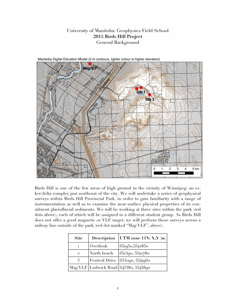
Birds Hill is one of the few areas of high ground in the vicinity of Winnipeg: an es-ker/delta complex just northeast of the city. We will undertake a series of geophysical surveys within Birds Hill Provincial Park, in order to gain familiarity with a range of instrumentation as well as to examine the near-surface physical properties of its con-stituent glaciofluvial sediments. We will be working at three sites within the park (red dots above), each of which will be assigned to a different student group. As Birds Hill does not offer a good magnetic or VLF target, we will perform those surveys across a railway line outside of the park (red dot marked “Mag/VLF”, above).
Site Description UTM zone 14N: X,Y (m)
1 Overlook 651950,5542850
2 North beach 651390, 5542780
3 Festival Drive 653090, 5541960
Mag/VLF Ludwick Road 645380, 5545890
2
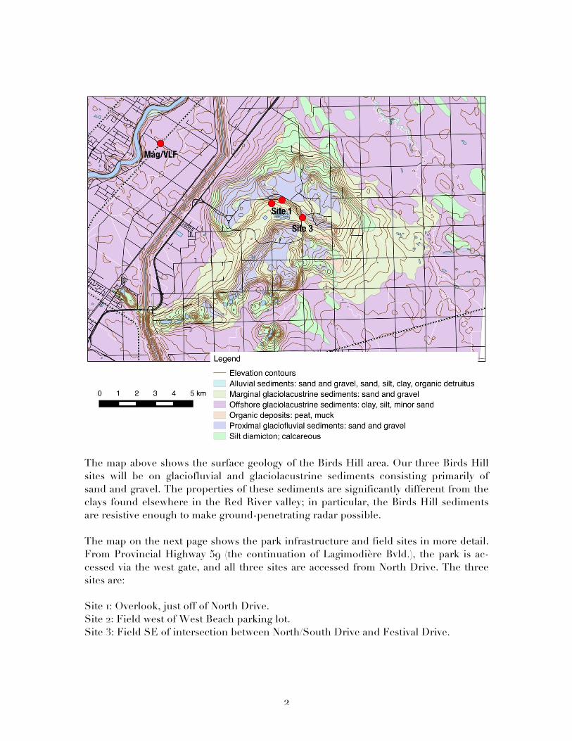
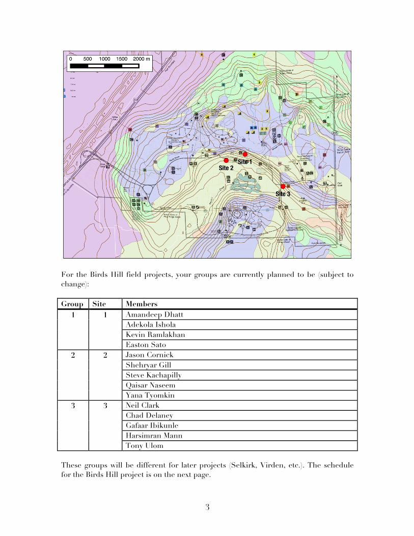
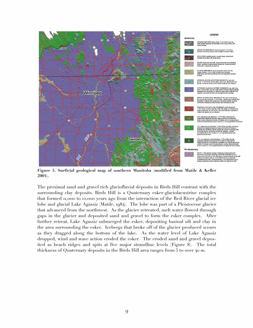
The map above shows the surface geology of the Birds Hill area. Our three Birds Hill sites will be on glaciofluvial and glaciolacustrine sediments consisting primarily of sand and gravel. The properties of these sediments are significantly different from the clays found elsewhere in the Red River valley; in particular, the Birds Hill sediments are resistive enough to make ground-penetrating radar possible. The map on the next page shows the park infrastructure and field sites in more detail. From Provincial Highway 59 (the continuation of Lagimodière Bvld.), the park is ac-cessed via the west gate, and all three sites are accessed from North Drive. The three sites are: Site 1: Overlook, just off of North Drive. Site 2: Field west of West Beach parking lot. Site 3: Field SE of intersection between North/South Drive and Festival Drive.
3
For the Birds Hill field projects, your groups are currently planned to be (subject to change): Group Site Members
1 1 Amandeep Dhatt Adekola Ishola Kevin Ramlakhan Easton Sato
2 2 Jason Cornick Shehryar Gill Steve Kachapilly Qaisar Naseem Yana Tyomkin
3 3 Neil Clark Chad Delaney Gafaar Ibikunle Harsimran Mann Tony Ulom
These groups will be different for later projects (Selkirk, Virden, etc.). The schedule for the Birds Hill project is on the next page.
4
Day Time Group 1 Group 2 Group 3 Tue., April 28 AM Seismic EM31/EM profiler GPR & TEM
PM GPR & TEM Seismic EM31/EM profiler Eve. Analysis Analysis Analysis
Wed., April 29 AM EM31/EM profiler GPR & TEM Seismic PM Gravity/Elevation DC Resistivity Mag-VLF Eve. Analysis Analysis Analysis
Thu., April 30 AM Mag-VLF Gravity/Elevation DC Resistivity PM DC Resistivity Mag-VLF Gravity/Elevation Eve. Analysis Analysis Analysis
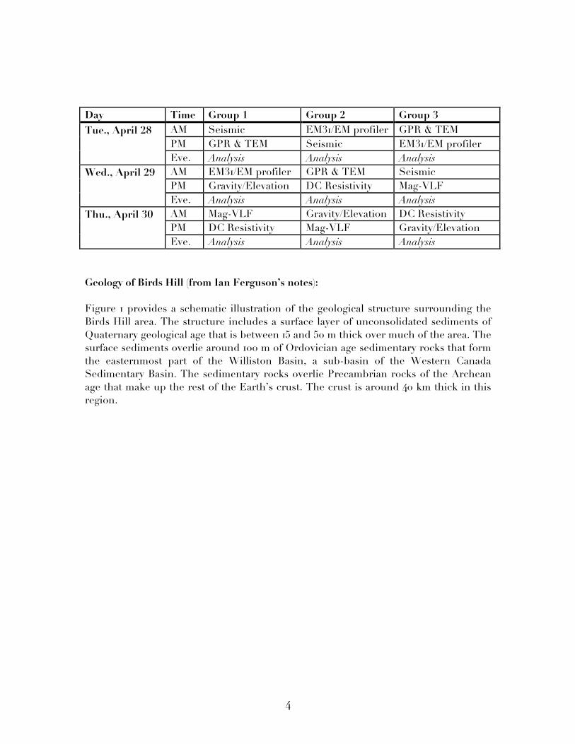
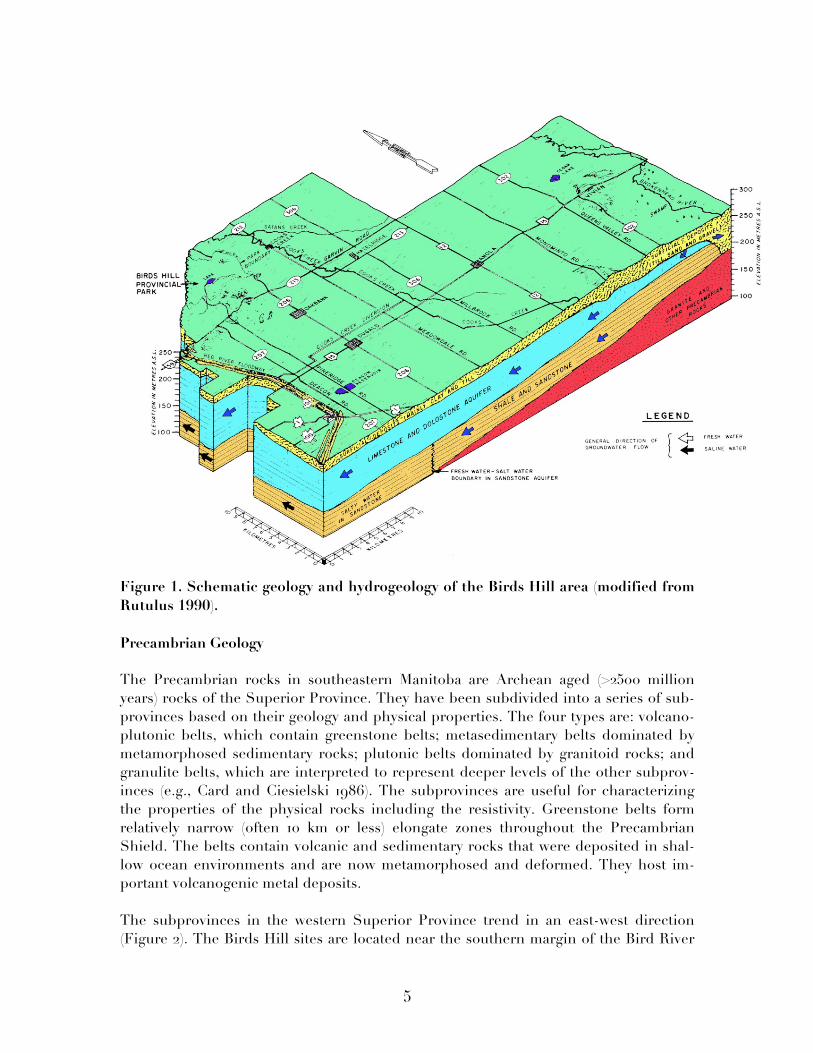
Geology of Birds Hill (from Ian Ferguson’s notes): Figure 1 provides a schematic illustration of the geological structure surrounding the Birds Hill area. The structure includes a surface layer of unconsolidated sediments of Quaternary geological age that is between 15 and 50 m thick over much of the area. The surface sediments overlie around 100 m of Ordovician age sedimentary rocks that form the easternmost part of the Williston Basin, a sub-basin of the Western Canada Sedimentary Basin. The sedimentary rocks overlie Precambrian rocks of the Archean age that make up the rest of the Earth’s crust. The crust is around 40 km thick in this region.
5
Figure 1. Schematic geology and hydrogeology of the Birds Hill area (modified from Rutulus 1990). Precambrian Geology The Precambrian rocks in southeastern Manitoba are Archean aged (>2500 million years) rocks of the Superior Province. They have been subdivided into a series of sub-provinces based on their geology and physical properties. The four types are: volcano-plutonic belts, which contain greenstone belts; metasedimentary belts dominated by metamorphosed sedimentary rocks; plutonic belts dominated by granitoid rocks; and granulite belts, which are interpreted to represent deeper levels of the other subprov-inces (e.g., Card and Ciesielski 1986). The subprovinces are useful for characterizing the properties of the physical rocks including the resistivity. Greenstone belts form relatively narrow (often 10 km or less) elongate zones throughout the Precambrian Shield. The belts contain volcanic and sedimentary rocks that were deposited in shal-low ocean environments and are now metamorphosed and deformed. They host im-portant volcanogenic metal deposits.
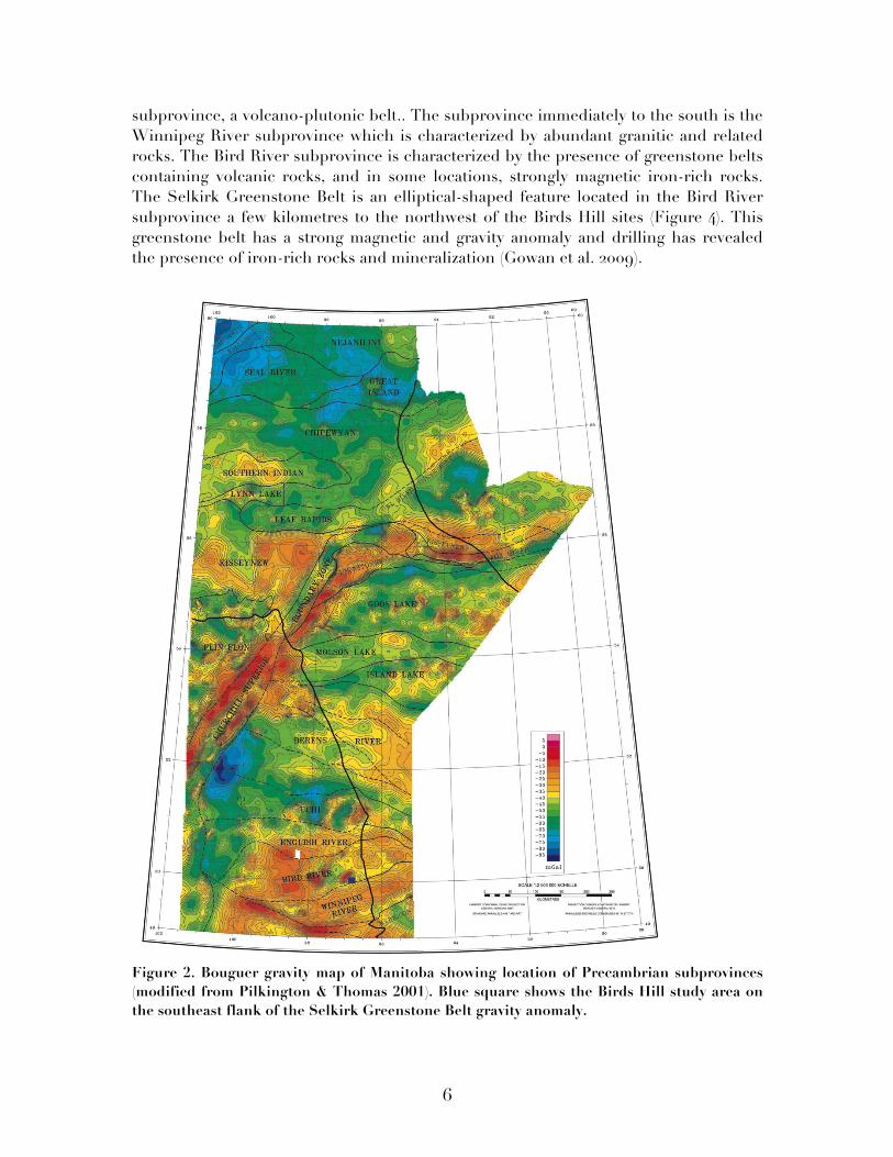
The subprovinces in the western Superior Province trend in an east-west direction (Figure 2). The Birds Hill sites are located near the southern margin of the Bird River
6
subprovince, a volcano-plutonic belt.. The subprovince immediately to the south is the Winnipeg River subprovince which is characterized by abundant granitic and related rocks. The Bird River subprovince is characterized by the presence of greenstone belts containing volcanic rocks, and in some locations, strongly magnetic iron-rich rocks. The Selkirk Greenstone Belt is an elliptical-shaped feature located in the Bird River subprovince a few kilometres to the northwest of the Birds Hill sites (Figure 4). This greenstone belt has a strong magnetic and gravity anomaly and drilling has revealed the presence of iron-rich rocks and mineralization (Gowan et al. 2009).
Figure 2. Bouguer gravity map of Manitoba showing location of Precambrian subprovinces (modified from Pilkington & Thomas 2001). Blue square shows the Birds Hill study area on the southeast flank of the Selkirk Greenstone Belt gravity anomaly.
7
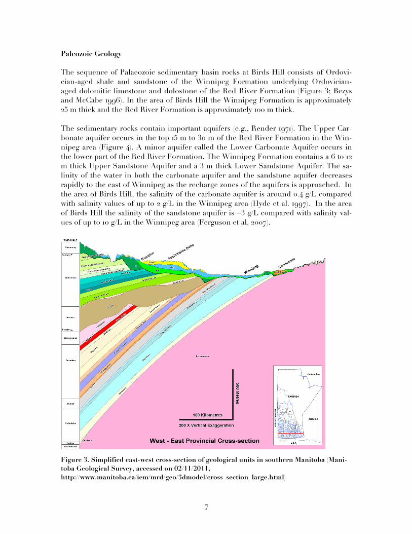
Paleozoic Geology The sequence of Palaeozoic sedimentary basin rocks at Birds Hill consists of Ordovi-cian-aged shale and sandstone of the Winnipeg Formation underlying Ordovician-aged dolomitic limestone and dolostone of the Red River Formation (Figure 3; Bezys and McCabe 1996). In the area of Birds Hill the Winnipeg Formation is approximately 25 m thick and the Red River Formation is approximately 100 m thick. The sedimentary rocks contain important aquifers (e.g., Render 1971). The Upper Car-bonate aquifer occurs in the top 15 m to 30 m of the Red River Formation in the Win-nipeg area (Figure 4). A minor aquifer called the Lower Carbonate Aquifer occurs in the lower part of the Red River Formation. The Winnipeg Formation contains a 6 to 12 m thick Upper Sandstone Aquifer and a 3 m thick Lower Sandstone Aquifer. The sa-linity of the water in both the carbonate aquifer and the sandstone aquifer decreases rapidly to the east of Winnipeg as the recharge zones of the aquifers is approached. In the area of Birds Hill, the salinity of the carbonate aquifer is around 0.4 g/L compared with salinity values of up to 2 g/L in the Winnipeg area (Hyde et al. 1997). In the area of Birds Hill the salinity of the sandstone aquifer is ~3 g/L compared with salinity val-ues of up to 10 g/L in the Winnipeg area (Ferguson et al. 2007).
Figure 3. Simplified east-west cross-section of geological units in southern Manitoba (Mani-toba Geological Survey, accessed on 02/11/2011, http://www.manitoba.ca/iem/mrd/geo/3dmodel/cross_section_large.html)
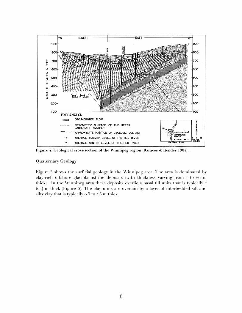
8
Figure 4. Geological cross-section of the Winnipeg region (Baracos & Render 1984). Quaternary Geology Figure 5 shows the surficial geology in the Winnipeg area. The area is dominated by clay-rich offshore glaciolacustrine deposits (with thickness varying from 1 to 20 m thick). In the Winnipeg area these deposits overlie a basal till units that is typically 2 to 4 m thick (Figure 6). The clay units are overlain by a layer of interbedded silt and silty clay that is typically 0.5 to 4.5 m thick.
9
Figure 5. Surficial geological map of southern Manitoba (modified from Matile & Keller 2004).
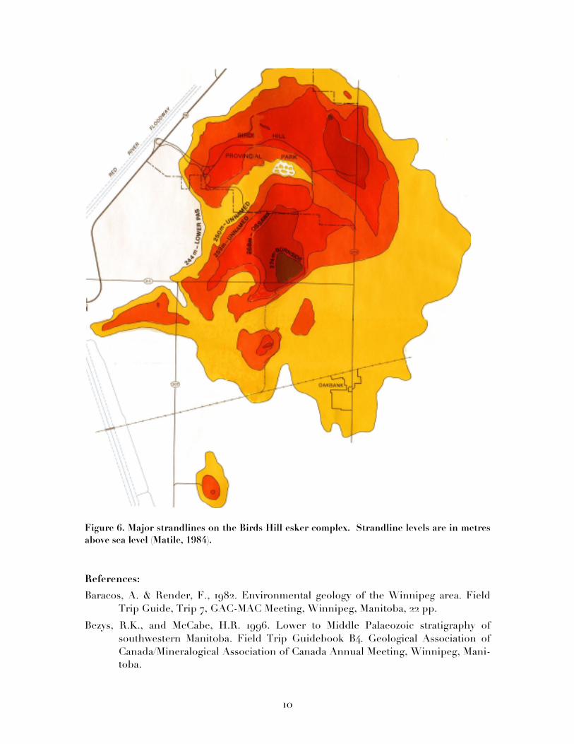
The proximal sand and gravel rich glaciofluvial deposits in Birds Hill contrast with the surrounding clay deposits. Birds Hill is a Quaternary esker-glaciolacustrine complex that formed 11,000 to 12,000 years ago from the interaction of the Red River glacial ice lobe and glacial Lake Agassiz (Matile, 1984). The lobe was part of a Pleistocene glacier that advanced from the northwest. As the glacier retreated, melt water flowed through gaps in the glacier and deposited sand and gravel to form the esker complex. After further retreat, Lake Agassiz submerged the esker, depositing basinal silt and clay in the area surrounding the esker. Icebergs that broke off of the glacier produced scours as they dragged along the bottom of the lake. As the water level of Lake Agassiz dropped, wind and wave action eroded the esker. The eroded sand and gravel depos-ited as beach ridges and spits at five major strandline levels (Figure 8). The total thickness of Quaternary deposits in the Birds Hill area ranges from 5 to over 40 m.
10
Figure 6. Major strandlines on the Birds Hill esker complex. Strandline levels are in metres above sea level (Matile, 1984).
References:
Baracos, A. & Render, F., 1982. Environmental geology of the Winnipeg area. Field Trip Guide, Trip 7, GAC-MAC Meeting, Winnipeg, Manitoba, 22 pp.
Bezys, R.K., and McCabe, H.R. 1996. Lower to Middle Palaeozoic stratigraphy of southwestern Manitoba. Field Trip Guidebook B4. Geological Association of Canada/Mineralogical Association of Canada Annual Meeting, Winnipeg, Mani-toba.
11
Card, K.D. & Ciesielski, A., 1986. DNAG Subdivisions of the Superior Province of the Canadian Shield. Geoscience Canada, 13, 5-13.
Ferguson, G.A.G., Betcher, R.N., and Grasby, S.E. 2007. Hydrogeoelogy of the Winnipeg Formation in Manitoba, Canada. Hydrogeology Journal, 15: doi:10.1007/s1O040-006-0130-4.
Gowan, E.J., Ferguson, I.J., Jones, A.G. & Craven, J.A., 2009. Geoelectric structure of the northeastern Williston basin and underlying Precambrian lithosphere. Can. J. Earth Sci., 46, 441-464.
Hyde, C.S.B., Betcher, R.N., Bezys, R.K., and Thorliefson, H.L. 1997. Transient electromagnetic sounding of saline groundwater-bearing Phanerozoic sequences, Manitoba Lowland, Poster presented at Manitoba Mining and Minerals Convention, Winnipeg, Manitoba.
Matile, G., 1984. Quaternary geology map of the Birds Hill area. Manitoba Energy and Mines, Mines Division, Map AR84-5, scale 1:20 000.
Matile, G. & Keller, G., 2004. Surficial geology of southern Manitoba (south of 53°); Manitoba Industry, Economic Development and Mines, Manitoba Geological Survey, Surficial Geology Compilation Map Series, SG-SMB, scale 1:500 000.
Pilkington, M. and Thomas, M.D., 2001. Magnetic and gravity maps with interpreted Precambrian basement, Manitoba. Open-File Report - Geological Survey of Canada, Report: 3739. 4 sheets.
Render, F.W., 1970. Geohydrology of the metropolitan Winnipeg area as related to groundwater supply and construction. Can. Geotech. J., 7, 243-274.
Rutulus, M., 1990. Groundwater resources in the rural municipality of Springfield: A s synopsis. Manitoba Water Resources, Hydrotechnical Services Division, Hydrogeology Section.