Embed Size (px)
Citation preview
A Thematic History of Bogan Shire
- Draft Report -
For Bogan Shire Council Dr Terry Kass, B A (Hons), M A (Hons), PhD Historian & Heritage Consultant 32 Jellicoe Street Lidcombe NSW 2141 (02) 9749 4128 January 2011
2
Table of Contents 1.0 Thematic History ..................................................................................................... 6
1.1 Contextual Essay & Theme – The Natural Landscape ........................................ 6
1.2 Contextual Essay - Occupation by Aboriginal Peoples/Murris .......................... 8
1.2.1 Theme – Living in harmony with the land .................................................... 8 1.2.2 Theme – Coping with invasion ..................................................................... 8
1.3 Contextual Essay – Settlement ........................................................................... 10
1.3.1 Theme – Exploring the Bogan region ......................................................... 10 1.3.2 Theme – Taking up pastoral land ................................................................ 10 1.3.3 Theme – Running livestock ........................................................................ 22 1.3.4 Theme – Building a railway ....................................................................... 23 1.3.5 Theme – Developing mineral wealth .......................................................... 24 1.3.6 Theme – Providing transport ...................................................................... 25 1.3.7 Theme – Creating towns and villages ......................................................... 27
1.3.7.1 Canonba ............................................................................................... 27 1.3.7.2 Nyngan ................................................................................................. 30 1.3.7.3 Girilambone ......................................................................................... 37 1.3.7.4 Hermidale ............................................................................................. 40 1.3.7.5 Coolabah .............................................................................................. 41 1.3.7.6 Bobadah ............................................................................................... 43 1.3.7.7 Miandetta ............................................................................................. 44
1.3.8 Theme – Promoting closer settlement ......................................................... 46 1.3.9 Theme - Altering the landscape .................................................................. 49
1.4 Contextual Essay – Working ............................................................................. 50
1.4.1 Theme - Working the land .......................................................................... 50 1.4.2 Theme – Working in town .......................................................................... 50 1.4.3 Theme - Manufacturing – working in workshops, mills or factories ......... 51
1.5 Contextual Essay - Providing accommodation .................................................. 55
1.5.1 Theme – Housing the rural dweller ............................................................ 55 1.5.2 Theme – Housing the town or village dweller ............................................ 56
1.6 Contextual Essay - Maintaining services and amenities .................................... 59
1.6.1 Theme - Providing utility services .............................................................. 59 1.6.2 Theme – Communicating ............................................................................ 60 1.6.3 Theme – Educating ..................................................................................... 61 1.6.4 Theme - Observing religious practices ....................................................... 62
3
1.6.5 Theme - Supplying retail, financial and professional services ................... 63 1.6.6 Theme - Caring for health ........................................................................... 73 1.6.7 Theme - Enjoying leisure ............................................................................ 74
1.7 Contextual Essay - Developing a community .................................................... 76
1.7.1 Theme – Governing .................................................................................... 76 1.7.2 Theme – Maintaining law and order ........................................................... 76 1.7.3 Theme - Defending the nation .................................................................... 78 1.7.4 Theme – Developing community services .................................................. 79 1.7.5 Theme - Excelling artistically or technically .............................................. 80 1.7.6 Theme - Diversifying the community ......................................................... 80 1.7.7 Theme – Coping with life events ................................................................ 81
2.0 Chronology ............................................................................................................ 83 3.0 Historical Themes for Bogan Shire Compared with National and State Themes 103 Bibliography .............................................................................................................. 112

4
Abbreviations C T Certificate of Title DP Deposited Plan JRAHS Journal of the Royal Australian Historical
Society LPMA Land and Property Management ML Mitchell Library NAA National Archives of Australia NSWGG New South Wales Government Gazette NSWPP New South Wales Parliamentary Papers SRNSW State Records of New South Wales V & P L A N S W Votes & Proceedings, Legislative Assembly,
NSW
5
Introduction This thematic history has been prepared as the first stage for the Bogan Shire Heritage Study Review. It is NOT meant to be comprehensive history of all aspects of the history of Bogan Shire due to limitations of time and budget. It has been framed in the light of the methodology recommended by the NSW Heritage Office. It identifies the main ‘themes’ or historical processes and developmental forces, which have shaped the landscapes and streetscapes of the area. These themes need to be identified in order to understand the context that created the physical evidence that survives of these past activities and lifestyles throughout the district. Ultimately, this document is a land-use planning tool, to assist the informed identification of heritage items and an appreciation of their historical context. The NSW Heritage Office Guidelines stress that Thematic Histories should rely largely upon published secondary sources, supplemented by research in maps and plans. Due to the lack of published secondary sources on a number of aspects of the history of Bogan Shire, some primary source research has been necessary to fill these gaps. Primary sources investigated include post office files held by the National Archives of Australia, land title records, the records of the NSW Dept of Lands now held by State Records of NSW, as well as school files and other relevant sources held by State Records of NSW. Some published primary sources such as the Government Gazette, NSW Parliamentary Papers and newspapers have also been used. How to Use this History This history is arranged in the following manner. The major sections are Contextual Essays such as ‘Settlement’ or ‘Providing Accommodation’. These provide a contextual history of change, development and continuity in Bogan Shire. All the Contextual Essays are labelled to assist the reader. The Contextual Essays are divided into sub-sections arranged by Theme. These ‘themes’ explain the principal forces of change that have shaped the development of the Bogan Shire and its peoples and created its current form. Such forces leave evidence of past practices, ways of life, technologies, economies, leisure activities and so on. Thus the arrangement of this history is: Contextual Essay Theme
6
1.0 Thematic History
1.1 Contextual Essay & Theme – The Natural Landscape Bogan Shire is located on the Darling Plain which is an extensive plain only occasionally relieved by a low ridge or an isolated hill. Sluggish rivers flowing north-westerly drain the area. The fall in height is so slight that in times of heavy rain the whole area becomes one huge lake.1 One report noted that ‘across the flat plains country … catchment boundaries are practically indeterminate’.2 The Bogan River, which rises west of the source of the Little River drains the shire that bears its name. A median rainfall about 20 inches of rain per annum is received by the Bogan, which flows northwest to join the Darling River near Bourke. 3 The average rainfall at Nyngan is 400 mm, though this varies considerably from year to year.4 Sedimentary and igneous rocks underlie the area around Nyngan. These have been eroded to form gravels, sand, silt and clay deposits along the river flats.5 Soils in that locality consist of brown light textured soils extending back on both sides of the Bogan River.6 West of the Bogan River, alluvial plains with grey clay are evident with cowals off the river catching seasonal high water flows and runoff. The cowals are usually lined with River Red Gum or Black Box. The rest of the area west of the Bogan consists of low rounded hills and ridges over metamorphosed Ordovician sediments that are vegetated with Red Box and Poplar Box.7 Summers are characterised by very hot weather over most of the Bogan Valley sometimes with extended periods with temperatures over 100º F (c. 38º C) for seven or more days. 8 Temperatures range from maximum of 34.3º C in January to 3.7º C in July. 9
1 Premiers Department, Macquarie Region, p 6-7 2 NSW - Water Resources and Irrigation Commission, The Water Resources of the Macquarie Valley including the Bogan River, p 2 3 NSW - Water Resources and Irrigation Commission, The Water Resources of the Macquarie Valley including the Bogan River, p 4-5 4 Bogan Shire Council, Annual Report, 2000-1, Environment Report, p 3 5 NSW – Dept of Water Resources, Water Resources of the Castlereagh, Macquarie and Bogan valleys, Dept, Parramatta 1991, p 4 6 Premiers Department, Macquarie Region, p 11 7 D Shelly, Flora and Fauna of Coolabah District, DLWC and Coolabah Landcare Group, Dubbo, 2000, p 3-4 8 NSW - Water Resources and Irrigation Commission, The Water Resources of the Macquarie Valley including the Bogan River, p 8 9 Bogan Shire Council, Annual Report, 2008-9, np
7
Rainfall suffers from a rain shadow effect causing most of the rain to fall on higher areas to the east. Rain is fairly evenly distributed over the year with a slight tendency for higher falls in January and February. 1 Sandstone strata from the artesian basin come close to the surface near Nyngan, providing some artesian supplies. Yet, since the water is not replenished in that part of the basin, its quality declines as you travel further down the river. East of the river near Nyngan, artesian water can be used for stock but west of the Bogan, the water is too saline for sheep. 2 Vegetation is mainly dry eucalypt woodland with swamp oak, and river red gum woodland near the river, with an under storey of roly-poly grass, fairy grass, windmill grass, sneeze weeds, lignum, native millet, neverfail and curly Mitchell grass. West of the river the vegetation is bimble box and red box woodland with areas of Wilga and Budda. 3
1 NSW – Dept of Water Resources, Water Resources of the Castlereagh, Macquarie and Bogan valleys, Dept, Parramatta 1991, p 5 2 NSW - Water Resources and Irrigation Commission, The Water Resources of the Macquarie Valley including the Bogan River, p 19-20 3 Bogan Shire Council, Annual Report, 2000-1, Environment Report, p 2
8
1.2 Contextual Essay - Occupation by Aboriginal Peoples/Murris
1.2.1 Theme – Living in harmony with the land Various meanings have been ascribed to the town name of Nyngan. According to some sources, it means mussel or crayfish. 1 According to W H Brotherton, son of an early settler, Nyngan means ‘meat’. He also noted that ‘Most of the stations and some of the towns in the Nyngan district are aboriginal names, and I think if some of our fair sex knew the meaning of some of them they would collapse every time they heard them or they would have to put extra powder on their face to hide their blushing.’ 2 Girilambone has been recorded as meaning ‘falling star’ or meteorite. 3 Tindale identified the Wongaibon Aboriginal language group as occupying the Bogan area as far as Cobar and Girilambone.4 The term now seems to be Wangaaypuwan.5 The 2008 Bogan Shire report stated that the shire was at western boundary of the Wiradjuri and that the Aboriginal residents were from the Wiradjuri and Kamilaroi groups.6
1.2.2 Theme – Coping with invasion Resistance to the loss of their traditional land was evident almost as soon as white European settlers started moving their livestock onto their lands. Whilst the deaths fof the white men killed in such encounters tended to be noted, the loss of Aboriginal people has been less carefully recorded. By 1840, William Lee senior and junior had taken up a run on the Bogan River running for 15 miles along the river from Mount Hopeless [on West Bogan No 11?]. Their licence had been issued on 19 August 1839 for the ‘Bogan and west of Wellington’.7 When their men were building a stockyard the local Aborigines attacked them. Three of their men were killed and buried in the stockyard. The Governor, George Gipps, would not accept any responsibility for their safety since they had gone too far beyond the range of police protection.8
1 Campbell, Nyngan, np 2 Campbell, Nyngan, np 3 J E Carne, Copper-Mining Industry, 1908, p 218 4 N B Tindale, Aboriginal tribes of Australia; their terrain, environmental controls, distribution, limits and proper names, Australian National University Press, Canberra 1974, p 201 and map 5 H Goodall, Invasion to Embassy: Land in Aboriginal Politics in New South Wales, 1770-1972, Allen & Unwin, St Leonards, 1996, p xiv 6 Bogan Shire Council, Community Plan, 2008-9 7 Treasury, Certificates of Depasturing Licences, SRNSW 4/92, No 275 8 Lds&PW58/3642, Lands and Public Works Department, Correspondence, SRNSW 5/3593
9
On 23 November 1840, a licence had been issued to Messrs Bolton for Mudall and ‘Marrow Bones’.1 Later, a licence had been issued to J O Balfour on 2 February 1842 for ‘Morigathery’ and ‘Marrow Bones’.2 William Abercrombie, a partner in Balfour and Co had four runs in the Wellington District by 1843. Two of the runs held by Balfour and Co, ‘Muddall’ and ‘Marrow Bones’ [Marebone?] were on the Bogan River. In 1843, his stockman Alexander Menzies was shifting sheep from Muddall when he was attacked. Two of his men were killed and the rest abandoned the stations. Before Balfour and Co took over the stations; five men had been killed on them. Francis Allman, Commissioner for Crown Lands reported in March 1843 that he had found the ‘Muddall’ tribe to be the fiercest of all.3 There is also a report that a group of white men were attacked at night in 1846 and killed except one at a place later called the ‘Murdering Stumps’ on Lee’s Tabratong station.4 Inter-tribal battles between Aborigines from the Bogan and Macquarie in the 1850s and 1860s were fierce with serious effects on white settlers. White settlers such as Monaghan and Lynch would ride out and scare off the Macquarie Aborigines with some firepower in order to prevent this. 5 The local Aborigines were claimed to still be very numerous in the early 1870s.6 The entry of larger numbers of white settlers into the area would have placed greater pressure on them. The concentration of white settlers was sparse, giving Aborigines opportunities to exist on land not so intensively used. Yet, in such a dry area whoever controlled the water sources commanded the surrounding area. Once squatters and selectors had control of these vital resources, opportunities for Aboriginal persistence were seriously eroded. In 1971, less than 20 people identified themselves as Aboriginal in either the Bogan Shire of Nyngan Municipality.7 The 2001 Census showed 329 people of ATS descent, possibly the result of greater willingness to acknowledge Aboriginal ancestry. 8 The later Census of 2006 showed 11.7% of the shire population was of Aboriginal or Torres Strait Islander descent, compared to 2.3% for the rest of Australia.9 By 2000, Bogan Shire had been alerted to a number of scarred trees in the shire and was liaising with the local Aboriginal community and the NPWS regarding preservation.10 The Bogan Aboriginal Corporation was registered on 19 January 1984. By 2008, the Bogan Aboriginal Corporation had made a notable contribution to housing local Aboriginal people.11
1 Treasury, Certificates of Depasturing Licences, SRNSW 4/94, No 555 2 Treasury, Certificates of Depasturing Licences, SRNSW 4/96, No 625 3 Lds&PW58/1726, Lands and Public Works Department, Correspondence, SRNSW 5/3588 4 Nyngan on Bogan, p 213 5 Back to Nyngan, p 7 6 Nyngan on Bogan, p 28 7 Bureau of Census and Statistics, The Aboriginal Population – Australia, 1971, (Ref 2.91), p 12 8 Bogan Shire Council, Community Plan, 2008-9 9 Bogan Shire Council, Annual Report, 2008-9, np 10 Bogan Shire Council, Annual Report, 2000-1, Environment Report, p 5 11 Bogan Shire Council, Community Plan, 2008-9
10
1.3 Contextual Essay – Settlement
1.3.1 Theme – Exploring the Bogan region Exploration of the Bogan River area was undertaken both by official surveyors and exploring parties and unofficially by stockmen moving livestock to new pastures for their employers. In 1833, the surveyor Robert Dixon traced part of the line of the Bogan River.1 More prominent was the formal exploring expeditions led by Surveyor-General, T L Mitchell, in 1835 and 1846, which crossed the area. On 10 May 1835 T L Mitchell came to site of Nyngan, which he called Nyingen. It had ponds with wildfowl. On the same expedition, his botanist, Richard Cunningham, went missing about 17 April 1835. He was killed by local aborigines about 25 April. He was later buried at Burdenda, Tottenham. 2 In his 1846 exploration, Mitchell crossed the area again. On 13 January, he found good water at ‘Darobal' (now Darouble). He noted that at the site of Nyngan that ‘large stockyards and a paddock remained but a house and garden fence had been burnt down’.3 He also found the burned remains of cattle stations at ‘Bugabada’, ‘Mudi’ and ‘Darabal’.4 He found more water at Canbelego on 18 January 1846, which has been identified as being two miles west of Moonagee Airfield.5 On 27 January 1846, he camped at ‘the ponds of Canonba’, which later became the site for the village.6
1.3.2 Theme – Taking up pastoral land The identity of the earliest squatters to take up land along the Bogan is unclear. Since the locations of many stations noted in the depasturing licences are unclear and the names of stations or runs have changed a number of times, it is uncertain if the correct names have been discovered. The Certificates of Depasturing licences held by State Records provide some clue but they would need more research to correctly identify all of the relevant stations. By 1840, William Lee senior and junior had taken up a run on the Bogan River running for 15 miles along the river from Mount Hopeless [on West Bogan No 11?]. Their licence had been issued on 19 August 1839 for the ‘Bogan and west of Wellington’.7 A licence was issued to J S Corse for
1 Nyngan on Bogan, p 22 2 Nyngan on Bogan, p 17 3 W C Foster, Sir Thomas Livingston Mitchell and his world, 1792-1855: Surveyor General of New South Wales, 1828-1855, Institution of Surveyors, NSW, Sydney, 1985, p 374-5 4 Nyngan on Bogan, p 18 5 W C Foster, Sir Thomas Livingston Mitchell, p 375 6 Nyngan on Bogan, p 19 7 Treasury, Certificates of Depasturing Licences, SRNSW 4/92, No 275
11
‘Graddell on Bogan Creek’ on 21 October 1839. 1 John Corse junior held ‘Gradell’ 31,000 acres on Bogan River in 1849.2 On 23 November 1840, a licence was issued to Messrs Bolton for Mudall and ‘Marrow Bones’ [Marebone?].3 The burned remains of cattle stations found by T L Mitchell on 16 January 1846 at ‘Bugabada’, ‘Mudi’ and ‘Darabal’ appear to relate to some of these stations.4 Colane was reputed to have taken up by Lyne and Tabyan taken up in the late 1830s, but no confirmation of this has been found. The property was later owned by A H McCulloch. His son Frank was killed in an accident on the property in December 1869 and he was buried in what was later known as the ‘Monument Paddock’. The house burned down about 1860 and new one was built half a mile from the old one and had a post office adjacent.5 Likewise, W Donohue (later of Merri Merri) was reputed to be the original holder of Canonba but no confirmation of this has been located. It later came into hands of John Brown.6 John Brown is claimed to have taken a lease of land near Canonba in February 1848. He used the aboriginal name ‘Carringbung’ which was corrupted to Canonbar or Cannonbar. The private township of Canonba known as Brownstown developed on his land. 7 On 20 August 1849, the boundaries of Brown's holding at Canonba were set by the Commissioner of Crown Lands so he was in occupation by then.8 As was common for opening up new areas with rough conditions, early settlers used cattle as the first stock on their runs since they were more robust. Sheep were too vulnerable for the country until late in the 1860s when John Brown of Canonbar and Richardson Brothers of Murrawombie installed wire fencing. 9 In 1854, Hugh Monahan [sic] and his wife arrived on the Bogan but were scared off by Aborigines. They returned in 1858 to take up land where Nyngan stands. Their daughter (Catherine) married (Peter) Lynch who took up West Bogan No 7 station. Their son J W was born on 12 June 1865 and acted as a significant informant for the 1928 history in the ‘Back to Nyngan’ publication.10 Much of the later history of the area has been based of his recollections, not always accurate and those of W H Brotherton. John Brown applied to purchase 160 acres around his homestead under his pre-emptive right in 1856. This was complicated by the fact that his land was partly on Reserve 88A. The Surveyor-General A G McLean decided the land was too remote and unimportant for the reserve to be needed. Additionally, Brown’s neighbour P O’Donoghue had built his hut on Brown's land since the boundaries were unclear. 1 Treasury, Certificates of Depasturing Licences, SRNSW 4/92, No 477 2 J F Campbell, 'Squatting' on Crown Land in New South Wales, Royal Australian Historical Society, Sydney, 1968, p 46 3 Treasury, Certificates of Depasturing Licences, SRNSW 4/94, No 555 4 Nyngan on Bogan, p 18 5 Nyngan on Bogan, p 63 6 Nyngan on Bogan, p 20 7 Nyngan on Bogan, p 19 8 SG56/13351 in SG58/6869, Surveyor-General, Letters Received, SRNSW 5/5535 9 Nyngan on Bogan, p 29 10 Back to Nyngan, p 7
12
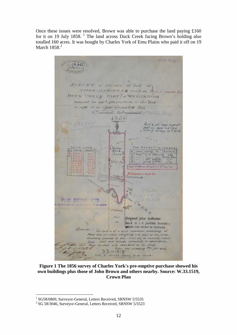
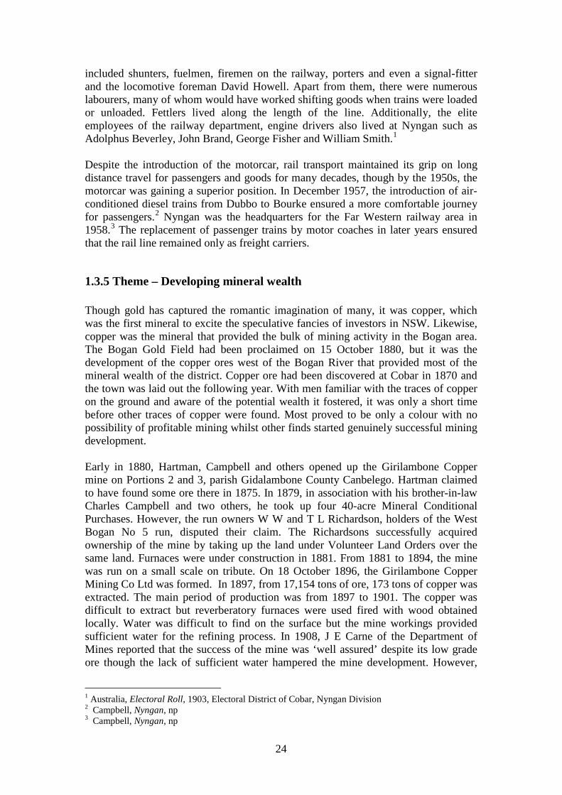
Once these issues were resolved, Brown was able to purchase the land paying £160 for it on 19 July 1858. 1 The land across Duck Creek facing Brown’s holding also totalled 160 acres. It was bought by Charles York of Emu Plains who paid it off on 19 March 1858.2
Figure 1 The 1856 survey of Charles York's pre-emptive purchase showed his
own buildings plus those of John Brown and others nearby. Source: W.33.1519, Crown Plan
1 SG58/6869, Surveyor-General, Letters Received, SRNSW 5/5535 2 SG 58/3046, Surveyor-General, Letters Received, SRNSW 5/5523
13
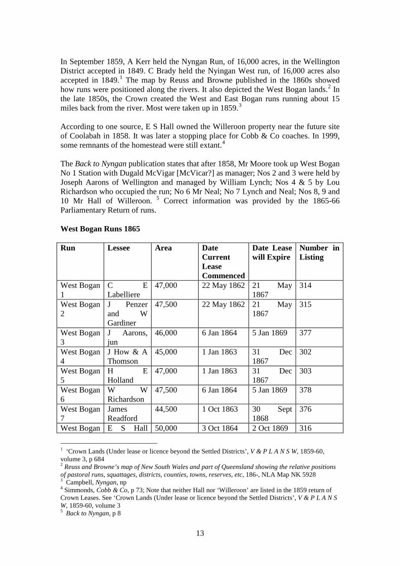
In September 1859, A Kerr held the Nyngan Run, of 16,000 acres, in the Wellington District accepted in 1849. C Brady held the Nyingan West run, of 16,000 acres also accepted in 1849.1 The map by Reuss and Browne published in the 1860s showed how runs were positioned along the rivers. It also depicted the West Bogan lands.2 In the late 1850s, the Crown created the West and East Bogan runs running about 15 miles back from the river. Most were taken up in 1859.3 According to one source, E S Hall owned the Willeroon property near the future site of Coolabah in 1858. It was later a stopping place for Cobb & Co coaches. In 1999, some remnants of the homestead were still extant.4 The Back to Nyngan publication states that after 1858, Mr Moore took up West Bogan No 1 Station with Dugald McVigar [McVicar?] as manager; Nos 2 and 3 were held by Joseph Aarons of Wellington and managed by William Lynch; Nos 4 & 5 by Lou Richardson who occupied the run; No 6 Mr Neal; No 7 Lynch and Neal; Nos 8, 9 and 10 Mr Hall of Willeroon. 5 Correct information was provided by the 1865-66 Parliamentary Return of runs. West Bogan Runs 1865 Run Lessee Area Date
Current Lease Commenced
Date Lease will Expire
Number in Listing
West Bogan 1
C E Labelliere
47,000 22 May 1862 21 May 1867
314
West Bogan 2
J Penzer and W Gardiner
47,500 22 May 1862 21 May 1867
315
West Bogan 3
J Aarons, jun
46,000 6 Jan 1864 5 Jan 1869 377
West Bogan 4
J How & A Thomson
45,000 1 Jan 1863 31 Dec 1867
302
West Bogan 5
H E Holland
47,000 1 Jan 1863 31 Dec 1867
303
West Bogan 6
W W Richardson
47,500 6 Jan 1864 5 Jan 1869 378
West Bogan 7
James Readford
44,500 1 Oct 1863 30 Sept 1868
376
West Bogan E S Hall 50,000 3 Oct 1864 2 Oct 1869 316
1 ‘Crown Lands (Under lease or licence beyond the Settled Districts’, V & P L A N S W, 1859-60, volume 3, p 684 2 Reuss and Browne’s map of New South Wales and part of Queensland showing the relative positions of pastoral runs, squattages, districts, counties, towns, reserves, etc, 186-, NLA Map NK 5928 3 Campbell, Nyngan, np 4 Simmonds, Cobb & Co, p 73; Note that neither Hall nor ‘Willeroon’ are listed in the 1859 return of Crown Leases. See ‘Crown Lands (Under lease or licence beyond the Settled Districts’, V & P L A N S W, 1859-60, volume 3 5 Back to Nyngan, p 8
14
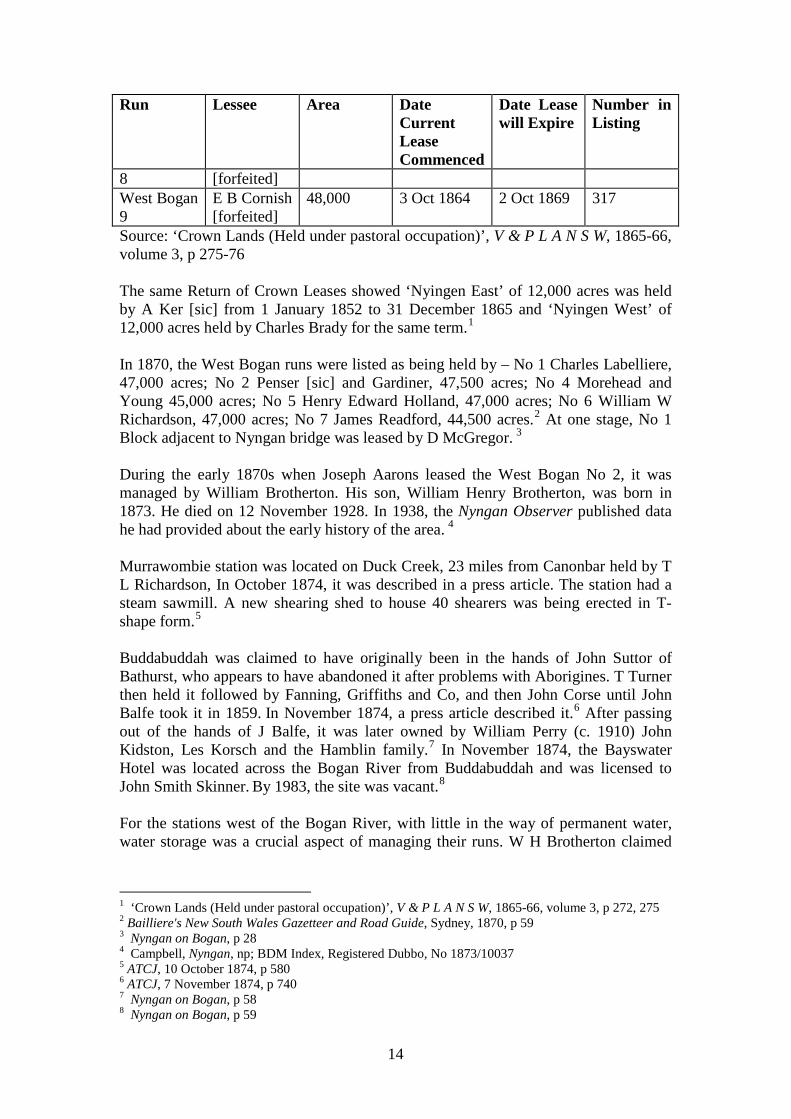
Run Lessee Area Date Current Lease Commenced
Date Lease will Expire
Number in Listing
8 [forfeited] West Bogan 9
E B Cornish [forfeited]
48,000 3 Oct 1864 2 Oct 1869 317
Source: ‘Crown Lands (Held under pastoral occupation)’, V & P L A N S W, 1865-66, volume 3, p 275-76 The same Return of Crown Leases showed ‘Nyingen East’ of 12,000 acres was held by A Ker [sic] from 1 January 1852 to 31 December 1865 and ‘Nyingen West’ of 12,000 acres held by Charles Brady for the same term.1 In 1870, the West Bogan runs were listed as being held by – No 1 Charles Labelliere, 47,000 acres; No 2 Penser [sic] and Gardiner, 47,500 acres; No 4 Morehead and Young 45,000 acres; No 5 Henry Edward Holland, 47,000 acres; No 6 William W Richardson, 47,000 acres; No 7 James Readford, 44,500 acres.2 At one stage, No 1 Block adjacent to Nyngan bridge was leased by D McGregor. 3 During the early 1870s when Joseph Aarons leased the West Bogan No 2, it was managed by William Brotherton. His son, William Henry Brotherton, was born in 1873. He died on 12 November 1928. In 1938, the Nyngan Observer published data he had provided about the early history of the area. 4 Murrawombie station was located on Duck Creek, 23 miles from Canonbar held by T L Richardson, In October 1874, it was described in a press article. The station had a steam sawmill. A new shearing shed to house 40 shearers was being erected in T-shape form.5 Buddabuddah was claimed to have originally been in the hands of John Suttor of Bathurst, who appears to have abandoned it after problems with Aborigines. T Turner then held it followed by Fanning, Griffiths and Co, and then John Corse until John Balfe took it in 1859. In November 1874, a press article described it.6 After passing out of the hands of J Balfe, it was later owned by William Perry (c. 1910) John Kidston, Les Korsch and the Hamblin family.7 In November 1874, the Bayswater Hotel was located across the Bogan River from Buddabuddah and was licensed to John Smith Skinner. By 1983, the site was vacant.8 For the stations west of the Bogan River, with little in the way of permanent water, water storage was a crucial aspect of managing their runs. W H Brotherton claimed
1 ‘Crown Lands (Held under pastoral occupation)’, V & P L A N S W, 1865-66, volume 3, p 272, 275 2 Bailliere's New South Wales Gazetteer and Road Guide, Sydney, 1870, p 59 3 Nyngan on Bogan, p 28 4 Campbell, Nyngan, np; BDM Index, Registered Dubbo, No 1873/10037 5 ATCJ, 10 October 1874, p 580 6 ATCJ, 7 November 1874, p 740 7 Nyngan on Bogan, p 58 8 Nyngan on Bogan, p 59
15
that his father William Brotherton built the first tank on the West Bogan on No 2 run.1 From the 1870s onwards, construction of wells and tanks commenced along the western stock routes. 2 By the early 1880s, the NSW Public Works Department had built a number of tanks along the stock route leading to Cobar. From 1 April 1881, the Booroomugga, Muriel and Hermitage Tanks on the road from Cobar to Nyngan were leased to Wright, Heaton & Co.3 On 21 November 1882, C W King surveyed Hermitage Government Tank (Portion 1, parish Nirranda County Canbelego) situated on the Hermitage Plains South Run, which showed the tank, a small tank, stables and a dwelling house.4 By 1880, large runs dominated the district though smaller one nestled amongst the larger ones. By 1880, John Brown’s property included Duck Creek, Mudall, Box Cowal, East Nyngan, Wera, Darouble, Glencoe, and Miowera.5 John Brown offered his large holding for sale in 1880 with about one million acres largely of leasehold. It was bought by William Alison for £160,000. 6 Alison later lived at ‘Box Cowal’ not ‘Belmont’ as Brown’s house had been known.7 John Brown died at Emu Plains aged 84 in 1888.8 On 15 July 1878, William Harvey Armstrong and Charles Trench Armstrong bought Callubri from W H Clements for £23,503/14/9.9 Dramatic change was about to occur. First the town of Nyngan was set up on the Nyngan East run. More fundamentally, two new Land Acts were passed in 1884 controlling all Crown Land alienation and occupation. NSW was divided into three Divisions, the Eastern, Central and Western Divisions. Bogan Shire is largely in the Central Division though small parts intrude into the Western Division.10 The Act allowed for pastoral leases, annual and special leases, scrub leases and conditional leaseholds.11 Free selection was still possible under this Act but the maximum area was enlarged by permitting the applicant to take up three-quarters of their selection as a Conditional Lease, with the proviso that it could later be converted into a Conditional Purchase.12
1 Campbell, Nyngan, np 2 NSW – Dept of Water Resources, Water Resources of the Castlereagh, Macquarie and Bogan valleys, Dept, Parramatta 1991, p 11 3 NSWGG, 25 March 1881, p 1611; See also D MacDonald, Map of New South Wales showing stock routes, tanks, wells and trucking stations, Melbourne, NLA Map Room 3193 4 W.117.1834, Crown Plan 5 Nyngan on Bogan, p 26 6 Nyngan on Bogan, p 26 7 Nyngan on Bogan, p 20 8 Nyngan on Bogan, p 19 9 Nyngan on Bogan, p 60-1 10 A G Lang, Crown Land, p 6 11 A G Lang, Crown Land, p 11 12 Cyclopaedia of New South Wales, McCarron Stewart & Co, Sydney, 1907, p 148
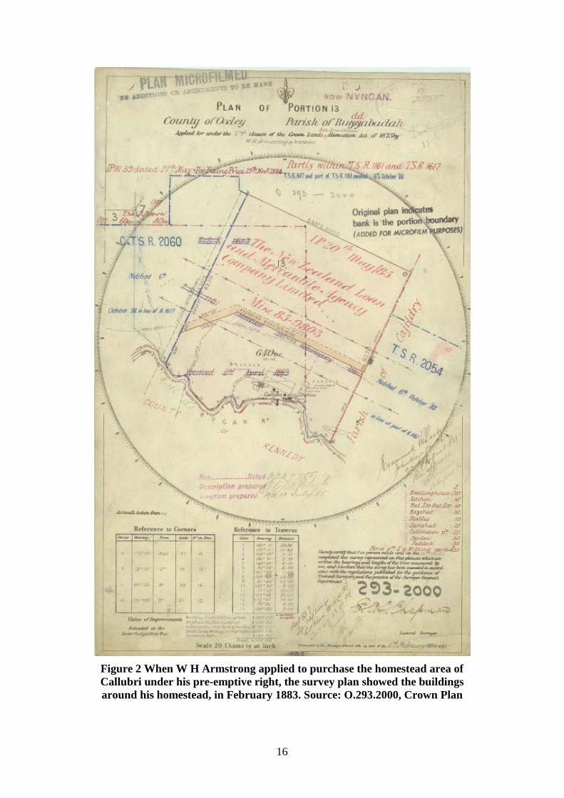
16
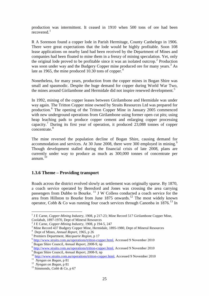
Figure 2 When W H Armstrong applied to purchase the homestead area of Callubri under his pre-emptive right, the survey plan showed the buildings around his homestead, in February 1883. Source: O.293.2000, Crown Plan
17
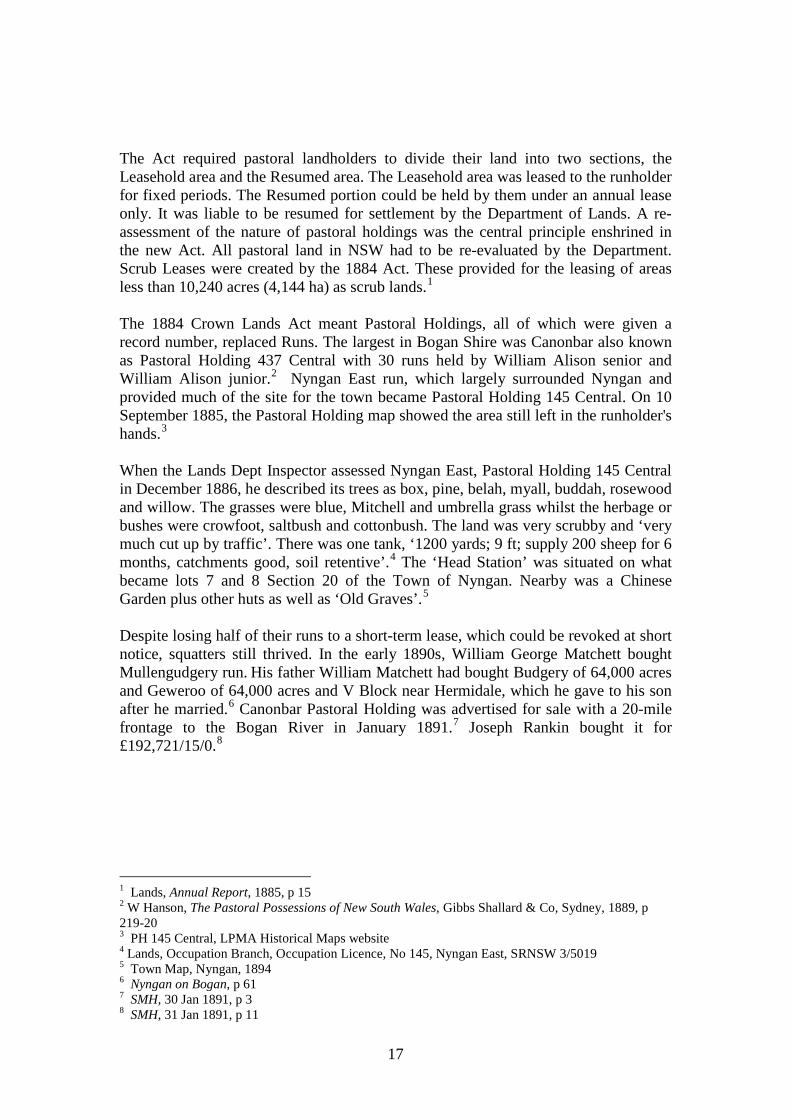
The Act required pastoral landholders to divide their land into two sections, the Leasehold area and the Resumed area. The Leasehold area was leased to the runholder for fixed periods. The Resumed portion could be held by them under an annual lease only. It was liable to be resumed for settlement by the Department of Lands. A re-assessment of the nature of pastoral holdings was the central principle enshrined in the new Act. All pastoral land in NSW had to be re-evaluated by the Department. Scrub Leases were created by the 1884 Act. These provided for the leasing of areas less than 10,240 acres (4,144 ha) as scrub lands.1 The 1884 Crown Lands Act meant Pastoral Holdings, all of which were given a record number, replaced Runs. The largest in Bogan Shire was Canonbar also known as Pastoral Holding 437 Central with 30 runs held by William Alison senior and William Alison junior.2 Nyngan East run, which largely surrounded Nyngan and provided much of the site for the town became Pastoral Holding 145 Central. On 10 September 1885, the Pastoral Holding map showed the area still left in the runholder's hands.3 When the Lands Dept Inspector assessed Nyngan East, Pastoral Holding 145 Central in December 1886, he described its trees as box, pine, belah, myall, buddah, rosewood and willow. The grasses were blue, Mitchell and umbrella grass whilst the herbage or bushes were crowfoot, saltbush and cottonbush. The land was very scrubby and ‘very much cut up by traffic’. There was one tank, ‘1200 yards; 9 ft; supply 200 sheep for 6 months, catchments good, soil retentive’.4 The ‘Head Station’ was situated on what became lots 7 and 8 Section 20 of the Town of Nyngan. Nearby was a Chinese Garden plus other huts as well as ‘Old Graves’.5 Despite losing half of their runs to a short-term lease, which could be revoked at short notice, squatters still thrived. In the early 1890s, William George Matchett bought Mullengudgery run. His father William Matchett had bought Budgery of 64,000 acres and Geweroo of 64,000 acres and V Block near Hermidale, which he gave to his son after he married.6 Canonbar Pastoral Holding was advertised for sale with a 20-mile frontage to the Bogan River in January 1891.7 Joseph Rankin bought it for £192,721/15/0.8
1 Lands, Annual Report, 1885, p 15 2 W Hanson, The Pastoral Possessions of New South Wales, Gibbs Shallard & Co, Sydney, 1889, p 219-20 3 PH 145 Central, LPMA Historical Maps website 4 Lands, Occupation Branch, Occupation Licence, No 145, Nyngan East, SRNSW 3/5019 5 Town Map, Nyngan, 1894 6 Nyngan on Bogan, p 61 7 SMH, 30 Jan 1891, p 3 8 SMH, 31 Jan 1891, p 11
18
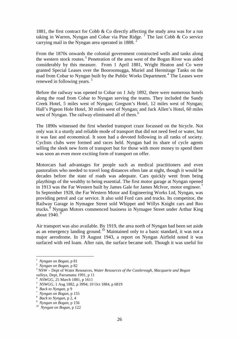
Figure 3 The head station and other buildings of the Nyngan run were shown on
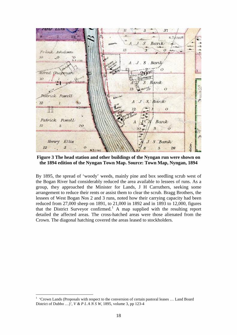
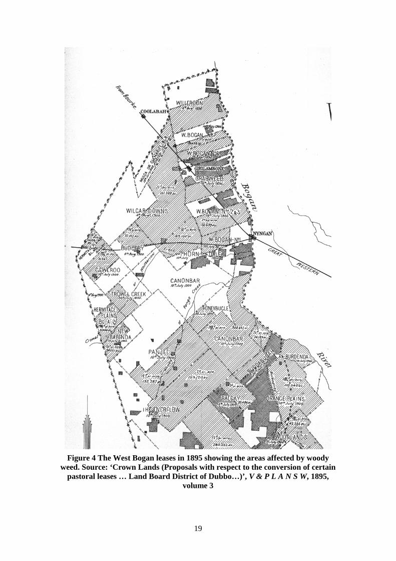
the 1894 edition of the Nyngan Town Map. Source: Town Map, Nyngan, 1894 By 1895, the spread of ‘woody’ weeds, mainly pine and box seedling scrub west of the Bogan River had considerably reduced the area available to lessees of runs. As a group, they approached the Minister for Lands, J H Carruthers, seeking some arrangement to reduce their rents or assist them to clear the scrub. Bragg Brothers, the lessees of West Bogan Nos 2 and 3 runs, noted how their carrying capacity had been reduced from 27,000 sheep on 1891, to 21,000 in 1892 and in 1893 to 12,000, figures that the District Surveyor confirmed.1 A map supplied with the resulting report detailed the affected areas. The cross-hatched areas were those alienated from the Crown. The diagonal hatching covered the areas leased to stockholders.
1 ‘Crown Lands (Proposals with respect to the conversion of certain pastoral leases … Land Board District of Dubbo …)’, V & P L A N S W, 1895, volume 3, pp 123-4
19
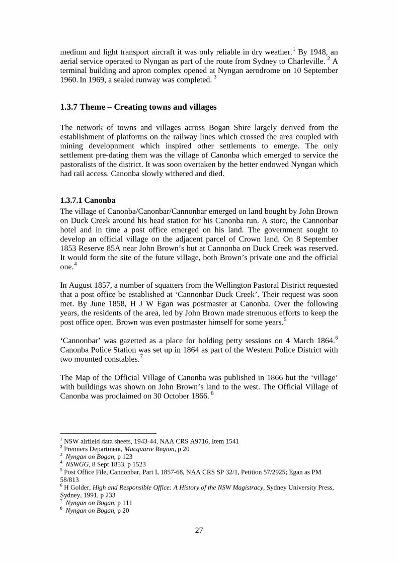
Figure 4 The West Bogan leases in 1895 showing the areas affected by woody
weed. Source: ‘Crown Lands (Proposals with respect to the conversion of certain pastoral leases … Land Board District of Dubbo…)’, V & P L A N S W, 1895,
volume 3
20
Subsequently, the Lands Department used unemployed labour to clear scrub on West Bogan. The operation was overseen from premises in Panjee Street.1 At the same time, a new condition was attached to Scrub Leases by the 1895 Lands Act. Scrub Leases had been available for land wholly or partly covered by scrub and could be leased by auction, tender or application for terms up to 21 years. The term was extended to 28 years by the 1895 Act. The holder had to destroy the scrub or noxious weeds and keep it free. In the final year of the lease the lessee could apply to convert it to a homestead grant of 640 acres. 2 The Improvement Lease was created by the 1895 Lands Act and allowed the leasing of scrub land not suitable for settlement, up to 28 years. Land classified as scrub or inferior could be taken up under this tenure. They were offered by auction or tender and were available up to a maximum of 20,480 acres. The term was 28 years. Conditions included improving the land under conditions drawn up for each case and the holder had tenant rights to any improvements. There was no compulsory residence requirement.3 The Settlement Lease was created by the 1895 Lands Act and was available for land set aside for this. It could be taken up for agriculture or grazing with a maximum of 1,280 acres for agricultural use and 10,240 for agriculture plus grazing. The term was 28 years later extended to 40 years. The holder had to reside on it for the whole term and enclose the holding within 5 years, and comply with conditions about noxious animals, scrub etc. The holder could apply to convert it to a homestead selection in the final year with an area of 1,280 acres. 4 By August 1896, six Improvement Leases covering 100,000 acres had been taken up and the pastoral lessees had also signed Scrub Leases over 562,000 acres. Settlement Leases were issued over nearly 100,000 acres. Under the control of the Department of Labour the unemployed would clear the scrub and ringbark from near the rail line from Nyngan to Coolabah and from Nyngan to Cobar.5 In September 1898, the Warren Herald reported that Colane Station had been bought by Fisher Brothers from the Bank of NSW for £40,000 for 40,000 acres. 6 Like stockowners across the state, Bogan pastoralists were severely affected by the droughts of the 1890s and 1900s. In 1902, a major drought at Nyngan still affected the district.7 The seasons soon turned. By 1906, pastoralists were benefiting from the prosperous conditions and there were ‘large increases in the number of sheep’ in the Dubbo Land Board District, which included Nyngan.8 In 1907 pastoralists were enjoying a good year with large increases in stock and high wool prices.9 The Canonbar Pastoral Holding was acquired by Goldsborough, Mort & Co in 1911. It set up Canonbar Merino Stud with its headquarters at Miowera where a new 1 Nyngan on Bogan, p 143 2 Occupation of Lands Guide, p 13-4 3 Occupation of Lands Guide, p 13 4 Occupation of Lands Guide, p 12-3 5 SMH, 13 Aug 1896, p 3 6 Nyngan on Bogan, p 63 7 Nyngan on Bogan, p 73 8 Lands, Annual Report, 1906, p 4 9 Lands, Annual Report, 1907, p 22
21
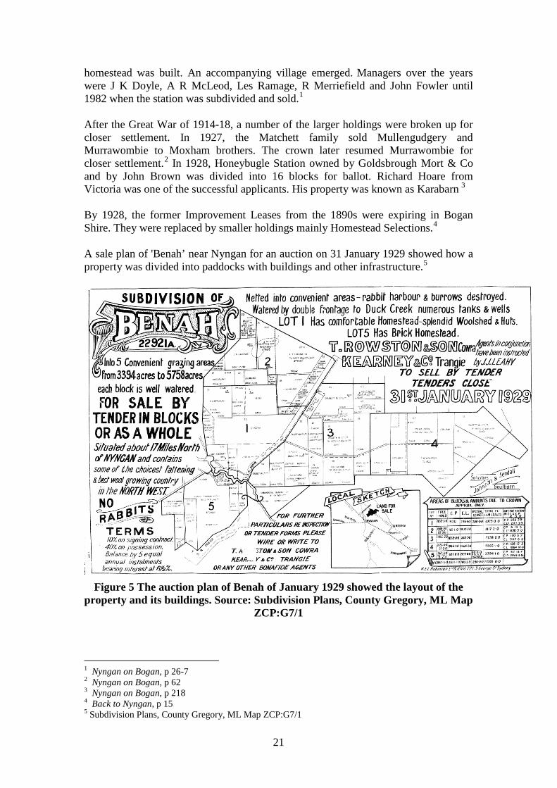
homestead was built. An accompanying village emerged. Managers over the years were J K Doyle, A R McLeod, Les Ramage, R Merriefield and John Fowler until 1982 when the station was subdivided and sold.1 After the Great War of 1914-18, a number of the larger holdings were broken up for closer settlement. In 1927, the Matchett family sold Mullengudgery and Murrawombie to Moxham brothers. The crown later resumed Murrawombie for closer settlement.2 In 1928, Honeybugle Station owned by Goldsbrough Mort & Co and by John Brown was divided into 16 blocks for ballot. Richard Hoare from Victoria was one of the successful applicants. His property was known as Karabarn 3 By 1928, the former Improvement Leases from the 1890s were expiring in Bogan Shire. They were replaced by smaller holdings mainly Homestead Selections.4 A sale plan of 'Benah’ near Nyngan for an auction on 31 January 1929 showed how a property was divided into paddocks with buildings and other infrastructure.5
Figure 5 The auction plan of Benah of January 1929 showed the layout of the
property and its buildings. Source: Subdivision Plans, County Gregory, ML Map ZCP:G7/1
1 Nyngan on Bogan, p 26-7 2 Nyngan on Bogan, p 62 3 Nyngan on Bogan, p 218 4 Back to Nyngan, p 15 5 Subdivision Plans, County Gregory, ML Map ZCP:G7/1
22
Running livestock, principally sheep, remained the main activity of the district. In 1940-1, Bogan Shire had 674,733 sheep and lambs, 16,793 cattle, 59 dairy cows, 346 pigs, and 2,553 horses but produced a very modest 4,094 bushels of wheat. 1 The role of sheep and shearing to the development of the area was acknowledged in the 1990s with the setting up of a museum at Nyngan displaying shearing equipment. By 2000, development of that museum of shearing equipment to be housed in the old railway goods shed was well advanced. 2
1.3.3 Theme – Running livestock Early settlers on the Bogan used cattle as the first stock on their land. Sheep were too vulnerable for the country until the late 1860s when John Brown of Canonbar and Richardson Brothers of Murrawombie installed wire fencing.3 Along with sheep came a need to house shearers when they visited stations to shear the sheep and shearing sheds and associated yards for that big annual event. From the 1870s, construction of wells and tanks commenced along the western stock routes.4 A new shearing shed was being built at Murrawombie station on Duck Creek, 23 miles from Canonbar by T L Richardson to house 40 shearers was being erected in T shape form.5 In the twentieth century, a number of sheep studs were set up in the Nyngan area. Francis Telfer Smith set up the Eudora Merino Stud in 1907. His son Max Smith took over in 1950, after the death of his father in 1945. 6 James McLaughlin established the Merryanbone Merino Stud on Duck Creek with 278 Collaroy Stud ewes and three Bundemar Stud rams in 1925. In 1953, it was transferred to his sons James and John. In 1978, it was transferred to John R McLaughlin. In 1979 the Merryanbone Poll Merino Stud was set up. 7 In 1927, the Mullengudgery Merino Stud, which had been formed near Bourke in 1923, was shifted to Mullengudgery by the Moxham Brothers. In 1962, the Moxham family company Mullengudgery Pty Ltd took over running the operation. 8 The first stud to produce Border Leicester sheep primarily for meat was established at Whitewoods by W W McLaughlin in 1928.9 In 1946, the Gudgery Border Leicester stud was set up by W E Gibson. When the flock was divided between his sons in 1976, one stud became the Mulla stud.10 T D and A W Volkofsky formed the Booralee Border Leicester Stud in 1968.11 1 Premiers Department, Macquarie Region, p 26 2 Bogan Shire Council, Annual Report, 2000-1, Environment Report, p 5 3 Nyngan on Bogan, p 29 4 NSW – Dept of Water Resources, Water Resources of the Castlereagh, Macquarie and Bogan valleys, Dept, Parramatta 1991, p 11 5 ATCJ, 10 October 1874, p 580 6 Nyngan on Bogan, p 31 7 Nyngan on Bogan, p 30 8 Nyngan on Bogan, p 30 9 Nyngan on Bogan, p 37 10 Nyngan on Bogan, p 37 11 Nyngan on Bogan, p 37
23
A Poll Hereford cattle stud was established at Glenhurst on Charles Kerz’s property in 1960.1 In 1969, a Poll Hereford cattle stud was formed at Gudgery Stud Park.2 In order to better serve the needs of the stockowners of the district, the Nyngan stock saleyards opened in June 1961.3 More recently, graziers have turned their attention to raising Dorpers, a Dorset cross with a large frame bred for meat.
1.3.4 Theme – Building a railway Almost all of the urban centres in Bogan shire emerged from the decision of the colonial government in Sydney to construct railways to Bourke and then to Cobar. As a significant shipping port on the Darling River, Bourke was the loading point for a good deal of pastoral and mining produce which was freighted down the river system to South Australia thereby draining away the trade from NSW. Intent on capturing that trade, the colonial government decided to construct a rail line to Bourke, which subsequently meant a railway station and village at Nyngan where the line crossed the Bogan River. Copper mining fuelled the development of the booming town of Cobar and inspired the construction of a rail line to serve it, which branched off the main line to Bourke from Nyngan. The tender of A & R Amos to build the railway from Dubbo to Nyngan was accepted on 21 December 1880.4 The partnership of Mann Carey & Co built the line from Nyngan to Bourke, which opened in 1885. Smith and Finlayson built the line from Nyngan to Cobar.5 After the railway reached Nyngan, the official opening ceremony was held there on 9 June 1883.6 For a time, Nyngan boomed. As the rail terminus, it attracted considerable trade for storekeepers and for those shifting goods such as teamsters. Thus, it was little wonder that those who had invested in the town were not anxious for the line to be extended to Bourke. When the railway was extended to Byrock on 2 September 1884 and from Byrock to Bourke on 3 September 1885, it caused a loss of interest in Nyngan. Many traders moved on to towns further along the line.7 The opening of the branch rail line from Nyngan Junction to Cobar on 1 July 1892 ensured a new boom. As a junction, Nyngan was often very busy when trains or mail arrived.8 This started a new boom in Nyngan, which created the core of the future town. 9 Apart from the commercial role of Nyngan serving the surrounding district, it was a major rail centre so that a substantial number of residents obtained their employment directly or indirectly from the railway. In 1903, residents of Nyngan
1 Nyngan on Bogan, p 38 2 Nyngan on Bogan, p 38 3 Nyngan on Bogan, p 109 4 Campbell, Nyngan, np 5 Campbell, Nyngan, np 6 Sydney Mail, 16 June 1883, p 1117 7 Back to Nyngan, p 9 8 Nyngan on Bogan, p 204 9 Back to Nyngan, p 9
24
included shunters, fuelmen, firemen on the railway, porters and even a signal-fitter and the locomotive foreman David Howell. Apart from them, there were numerous labourers, many of whom would have worked shifting goods when trains were loaded or unloaded. Fettlers lived along the length of the line. Additionally, the elite employees of the railway department, engine drivers also lived at Nyngan such as Adolphus Beverley, John Brand, George Fisher and William Smith.1 Despite the introduction of the motorcar, rail transport maintained its grip on long distance travel for passengers and goods for many decades, though by the 1950s, the motorcar was gaining a superior position. In December 1957, the introduction of air-conditioned diesel trains from Dubbo to Bourke ensured a more comfortable journey for passengers.2 Nyngan was the headquarters for the Far Western railway area in 1958.3 The replacement of passenger trains by motor coaches in later years ensured that the rail line remained only as freight carriers.
1.3.5 Theme – Developing mineral wealth Though gold has captured the romantic imagination of many, it was copper, which was the first mineral to excite the speculative fancies of investors in NSW. Likewise, copper was the mineral that provided the bulk of mining activity in the Bogan area. The Bogan Gold Field had been proclaimed on 15 October 1880, but it was the development of the copper ores west of the Bogan River that provided most of the mineral wealth of the district. Copper ore had been discovered at Cobar in 1870 and the town was laid out the following year. With men familiar with the traces of copper on the ground and aware of the potential wealth it fostered, it was only a short time before other traces of copper were found. Most proved to be only a colour with no possibility of profitable mining whilst other finds started genuinely successful mining development. Early in 1880, Hartman, Campbell and others opened up the Girilambone Copper mine on Portions 2 and 3, parish Gidalambone County Canbelego. Hartman claimed to have found some ore there in 1875. In 1879, in association with his brother-in-law Charles Campbell and two others, he took up four 40-acre Mineral Conditional Purchases. However, the run owners W W and T L Richardson, holders of the West Bogan No 5 run, disputed their claim. The Richardsons successfully acquired ownership of the mine by taking up the land under Volunteer Land Orders over the same land. Furnaces were under construction in 1881. From 1881 to 1894, the mine was run on a small scale on tribute. On 18 October 1896, the Girilambone Copper Mining Co Ltd was formed. In 1897, from 17,154 tons of ore, 173 tons of copper was extracted. The main period of production was from 1897 to 1901. The copper was difficult to extract but reverberatory furnaces were used fired with wood obtained locally. Water was difficult to find on the surface but the mine workings provided sufficient water for the refining process. In 1908, J E Carne of the Department of Mines reported that the success of the mine was ‘well assured’ despite its low grade ore though the lack of sufficient water hampered the mine development. However,
1 Australia, Electoral Roll, 1903, Electoral District of Cobar, Nyngan Division 2 Campbell, Nyngan, np 3 Campbell, Nyngan, np
25
production was intermittent. It ceased in 1910 when 500 tons of ore had been recovered.1 R A Sorenson found a copper lode in Parish Hermitage, County Canbelego in 1906. There were great expectations that the lode would be highly profitable. Soon 108 lease applications on nearby land had been received by the Department of Mines and companies had been floated to mine them in a frenzy of mining speculation. Yet, only the original lode proved to be profitable since it was an isolated outcrop.2 Production was soon under way and the Budgery Copper mine produced ore for many years.3 As late as 1965, the mine produced 10.30 tons of copper.4 Nonetheless, for many years, production from the copper mines in Bogan Shire was small and spasmodic. Despite the huge demand for copper during World War Two, the mines around Girilambone and Hermidale did not inspire renewed development.5 In 1992, mining of the copper leases between Girilambone and Hermidale was under way again. The Tritton Copper mine owned by Straits Resources Ltd was prepared for production.6 The opening of the Tritton Copper Mine in January 2005 commenced with new underground operations from Girilambone using former open cut pits; using heap leaching pads to produce copper cement and enlarging copper processing capacity.7 During its first year of operation, it produced 23,088 tonnes of copper concentrate.8 The mine reversed the population decline of Bogan Shire, causing demand for accommodation and services. At 30 June 2008, there were 300 employed in mining.9 Though development stalled during the financial crisis of late 2008, plans are currently under way to produce as much as 300,000 tonnes of concentrate per annum.10
1.3.6 Theme – Providing transport Roads across the district evolved slowly as settlement was originally sparse. By 1870, a coach service operated by Beresford and Jones was crossing the area carrying passengers from Dubbo to Bourke. 11 J W Colless conducted a coach service for the area from Hillston to Bourke from June 1875 onwards.12 The most widely known operator, Cobb & Co was running four coach services through Canonba in 1876.13 In
1 J E Carne, Copper-Mining Industry, 1908, p 217-23; Mine Record 517 Girilambone Copper Mine, Coolabah, 1897-1970, Dept of Mineral Resources 2 J E Carne, Copper-Mining Industry, 1908, p 194-5, 247 3 Mine Record 437 Budgery Copper Mine, Hermidale, 1895-1980, Dept of Mineral Resources 4 Dept of Mines, Annual Report, 1965, p 26 5 Premiers Department, Macquarie Region, p 17 6 http://www.straits.com.au/operations/tritton-copper.html, Accessed 9 November 2010 7 Bogan Shire Council, Annual Report, 2008-9, np 8 http://www.straits.com.au/operations/tritton-copper.html, Accessed 9 November 2010 9 Bogan Shire Council, Annual Report, 2008-9, np 10 http://www.straits.com.au/operations/tritton-copper.html, Accessed 9 November 2010 11 Nyngan on Bogan, p 81 12 Nyngan on Bogan, p 81 13 Simmonds, Cobb & Co, p 67
26
1881, the first contract for Cobb & Co directly affecting the study area was for a run taking in Warren, Nyngan and Cobar via Pine Ridge. 1 The last Cobb & Co service carrying mail in the Nyngan area operated in 1888. 2 From the 1870s onwards the colonial government constructed wells and tanks along the western stock routes.3 Penetration of the area west of the Bogan River was aided considerably by this measure. From 1 April 1881, Wright Heaton and Co were granted Special Leases over the Booroomugga, Muriel and Hermitage Tanks on the road from Cobar to Nyngan built by the Public Works Department.4 The Leases were renewed in following years. 5 Before the railway was opened to Cobar on 1 July 1892, there were numerous hotels along the road from Cobar to Nyngan serving the teams. They included the Sandy Creek Hotel, 5 miles west of Nyngan; Gregson’s Hotel, 12 miles west of Nyngan; Hall’s Pigeon Hole Hotel, 30 miles west of Nyngan; and Jack Allen’s Hotel, 60 miles west of Nyngan. The railway eliminated all of them.6 The 1890s witnessed the first wheeled transport craze focussed on the bicycle. Not only was it a sturdy and reliable mode of transport that did not need feed or water, but it was fast and economical. It soon had a devoted following in all ranks of society. Cyclists clubs were formed and races held. Nyngan had its share of cycle agents selling the sleek new form of transport but for those with more money to spend there was soon an even more exciting form of transport on offer. Motorcars had advantages for people such as medical practitioners and even pastoralists who needed to travel long distances often late at night, though it would be decades before the state of roads was adequate. Cars quickly went from being playthings of the wealthy to being essential. The first motor garage at Nyngan opened in 1913 was the Far Western built by James Gale for James McIvor, motor engineer.7 In September 1928, the Far Western Motor and Engineering Works Ltd, Nyngan, was providing petrol and car service. It also sold Ford cars and trucks. Its competitor, the Railway Garage in Nymagee Street sold Whippet and Willys Knight cars and Reo trucks.8 Nyngan Motors commenced business in Nymagee Street under Arthur King about 1940. 9 Air transport was also available. By 1919, the area north of Nyngan had been set aside as an emergency landing ground.10 Maintained only to a basic standard, it was not a major aerodrome. In 19 August 1943, a report on Nyngan Airfield noted it was surfaced with red loam. After rain, the surface became soft. Though it was useful for
1 Nyngan on Bogan, p 81 2 Nyngan on Bogan, p 82 3 NSW – Dept of Water Resources, Water Resources of the Castlereagh, Macquarie and Bogan valleys, Dept, Parramatta 1991, p 11 4 NSWGG, 25 March 1881, p 1611 5 NSWGG, 1 Aug 1882, p 3994; 10 Oct 1884, p 6819 6 Back to Nyngan, p 9 7 Nyngan on Bogan, p 155 8 Back to Nyngan, p 2, 4 9 Nyngan on Bogan, p 156 10 Nyngan on Bogan, p 122
27
medium and light transport aircraft it was only reliable in dry weather.1 By 1948, an aerial service operated to Nyngan as part of the route from Sydney to Charleville. 2 A terminal building and apron complex opened at Nyngan aerodrome on 10 September 1960. In 1969, a sealed runway was completed. 3
1.3.7 Theme – Creating towns and villages The network of towns and villages across Bogan Shire largely derived from the establishment of platforms on the railway lines which crossed the area coupled with mining developnment which inspired other settlements to emerge. The only settlement pre-dating them was the village of Canonba which emerged to service the pastoralists of the district. It was soon overtaken by the better endowed Nyngan which had rail access. Canonba slowly withered and died.
1.3.7.1 Canonba The village of Canonba/Canonbar/Cannonbar emerged on land bought by John Brown on Duck Creek around his head station for his Canonba run. A store, the Cannonbar hotel and in time a post office emerged on his land. The government sought to develop an official village on the adjacent parcel of Crown land. On 8 September 1853 Reserve 85A near John Brown’s hut at Cannonba on Duck Creek was reserved. It would form the site of the future village, both Brown’s private one and the official one.4 In August 1857, a number of squatters from the Wellington Pastoral District requested that a post office be established at ‘Cannonbar Duck Creek’. Their request was soon met. By June 1858, H J W Egan was postmaster at Canonba. Over the following years, the residents of the area, led by John Brown made strenuous efforts to keep the post office open. Brown was even postmaster himself for some years.5 ‘Cannonbar’ was gazetted as a place for holding petty sessions on 4 March 1864.6 Canonba Police Station was set up in 1864 as part of the Western Police District with two mounted constables.7 The Map of the Official Village of Canonba was published in 1866 but the ‘village’ with buildings was shown on John Brown’s land to the west. The Official Village of Canonba was proclaimed on 30 October 1866. 8
1 NSW airfield data sheets, 1943-44, NAA CRS A9716, Item 1541 2 Premiers Department, Macquarie Region, p 20 3 Nyngan on Bogan, p 123 4 NSWGG, 8 Sept 1853, p 1523 5 Post Office File, Cannonbar, Part I, 1857-68, NAA CRS SP 32/1, Petition 57/2925; Egan as PM 58/813 6 H Golder, High and Responsible Office: A History of the NSW Magistracy, Sydney University Press, Sydney, 1991, p 233 7 Nyngan on Bogan, p 111 8 Nyngan on Bogan, p 20
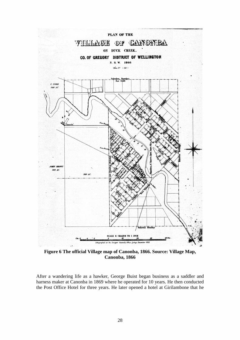
28
Figure 6 The official Village map of Canonba, 1866. Source: Village Map,
Canonba, 1866 After a wandering life as a hawker, George Buist began business as a saddler and harness maker at Canonba in 1869 where he operated for 10 years. He then conducted the Post Office Hotel for three years. He later opened a hotel at Girilambone that he

29
had built himself. After his mining investments failed he became the licensee of Tattersall’s Hotel in Nyngan where he died in 1888.1 Bailliere’s Guide of 1870 noted that Cannonbar was not a township (i.e. an official town). Yet petty sessions courts could be held there and there was a public pound. The buildings of the town were situated on John Brown’s 320-acre freehold. They included a post office, store, and the Cannonbar hotel (Brown’s). The population was about 20 people.2 A map of Brownstown dated 22 July 1870 adjacent to the official town of Canonba, possibly for a private subdivision was published in the Nyngan on the Bogan publication.3
Figure 7 A map of Brownstown dated 22 July 1870 adjacent to the official town of Canonba, possibly for a private subdivision. Source: Nyngan on the Bogan, p
18 By the 1870s, at the height of its importance, Canonba had three or four banks, four hotels, stores, skilled tradesmen, a police station, a telegraph and money order office, a school and churches. 4 Storekeepers included S Sullivan, A Cass and Chinaman Sam Ring.5 On 25 June 1871, a traveller noted two hotels, two stores, a boot and shoemaker, a blacksmith and wheelwright, the Courthouse and lock-up and some private houses in Brownstown. At Canonba adjacent, there was one hotel, one store,
1 Australian Men of Mark, C F Maxwell, Sydney, Volume 2, 1889, p 342 2 Bailliere's New South Wales Gazetteer and Road Guide, Sydney, 1870, p 119 3 Nyngan on Bogan, p 18 4 Nyngan on Bogan, p 19 5 Campbell, Nyngan, np
30
one butcher, a baker, a saddle and harness maker and a few bark huts.1 A police report of 1 May 1872 stated there were 500 people at Canonba either in the village or the district.2 In 1873, there were three hotels licensed for Canonba, John Cuff’s Cannonbar Hotel, Henry Isaac’s Royal Hotel and John Quin’s Commercial Hotel.3 On 13 January 1876, two men robbed the manager of the Commercial Bank at Canonba of his keys. They got away with £1,500 from the bank safe. Sub-Inspector Keegan and Senior Constable Laughton captured one of them at Bourke.4 A public school had opened at Canonba in January 1871. It opened and closed a number of times as the population fluctuated.5 The tender of John Herrick to build a bridge across Duck Creek at 'Canonbar' was accepted in July 1873.6 Yet, according to W H Brotherton a long-time local resident, Mr Banks built the bridge. 7 Tenders to erect a brick police station with two cells on land reserved on Duck Creek at Canonba were offered in January 1877. 8 In 1881, just as Nyngan was starting to emerge, the population of Canonba was 472.9 But, the establishment of Nyngan sucked the life out of Canonba. On 21 December 1883, petty sessions were abolished at ‘Cannonbar’.10 Nyngan had previously been gazetted as a place for petty sessions on 18 May 1883. 11 The public school finally closed in September 1890.12 The 1891 Census gave the population of Canonba as 58 with 12 dwellings. 13
1.3.7.2 Nyngan On 8 September 1853, Reserve from Lease No 86 of 900 acres at ‘Nyingan’ was gazetted ‘about half a mile south from Mr Kerr’s hut’.14 It later formed the site for the town. Later, on 22 December 1865, Water Reserve No 150 was set aside at Nyngan.15 About 1867, Robert Paton built a hotel called the Traveller’s Rest near the river on his selection about half a mile north-west of the later site of Nyngan railway station. It was roughly built of slabs. After he died, it passed to his brother-in-law J Bonsworth.
1 Nyngan on Bogan, p 20 2 Nyngan on Bogan, p 111 3 NSWGG, 9 Sept 1873, p 2462 4 SMH, 15 Jan 1876, p 9; 31 Jan 1876, p 5 5 NSW – Dept of School Education, Government Schools of New South Wales 1848 to 1993, Dept of School Education, 1993, Sydney, p 45 6 SMH, 12 Jul 1873, p 12 7 Campbell, Nyngan, np 8 SMH, 22 Jan 1877, p 9 9 Nyngan on Bogan, p 19 10 H Golder, High and Responsible Office: A History of the NSW Magistracy, Sydney University Press, Sydney, 1991, p 233 11 H Golder, High and Responsible Office: A History of the NSW Magistracy, Sydney University Press, Sydney, 1991, p 246 12 NSW – Dept of School Education, Government Schools of New South Wales 1848 to 1993, Dept of School Education, 1993, Sydney, p 45 13 1891 Census, p 541 14 NSWGG, 8 Sept 1853, p 1523; SR Map 24584 15 NSWGG, 23 Dec 1865, p 2938
31
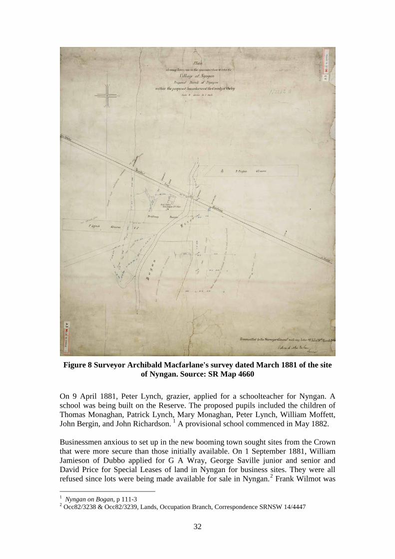
The building later burned down and its site became the brickyards.1 The Traveller’s Rest Hotel was located on the Moonagee Road opposite its corner with Nymagee Street and was kept by Harry Davis. Its licence was forfeited when the road was altered. James Gale bought the land and started his brickyards on the site. W and E Richards from Enfield were the first brickmakers. James Gale also owned a number of properties in Nyngan.2 The hotel was on Portion 1, Parish Bergo, County Gregory. A house and stables was shown on the original Crown survey of 4 September 1875.3 These buildings were later shown as a hotel on the early plans of the village of Nyngan. Previously, in 1872, Patrick Lynch had taken a Conditional Purchase on 40 acres west of the Bogan River in West Bogan No 1 run (Portion 1, Parish Lynch). This may have been to protect his house on the land. When surveyed on 1 November 1873, there were huts and a garden on the land.4 Reserve 1149 for a future village at Nyngan plus a depot for stock and for the railway on part of Nyngan West and East Bogan No 1 runs was gazetted on 9 February 1880.5 Before a rail line was completed and any train arrived at Nyngan, there was a rush to build but activity focussed on the area about a mile from the main town on the river. There, Thomas Rowe built Tattersall’s Hotel and James Dunn erected the Royal Hotel at the corner of Nyngan and Ford Streets. James Mooney built a hotel on the opposite side of the river. T Monahan built a hotel opposite Mooney’s.6 Most were of rough construction built from locally available materials.7 On 16 September 1880, a post office commenced at Thomas Rowe’s Tattersall’s Hotel, Nyngan.8 The tender of A & R Amos to build the railway from Dubbo to Nyngan was accepted on 21 December 1880.9 Mann Carey & Co later built the line from Nyngan to Bourke, which opened in 1885.10 At first, Nyngan was simply a collection of rough huts or tents.11 But, once the town was surveyed, proclaimed and lots offered for sale it began to acquire the look of a civilised place. On 18 March 1881, surveyor Archibald McFarlane reported on the site of Nyngan and sent in his plan of the town site. On the west side of the Bogan was the head station of the ‘West Bogan No 1 Run’ held by Hugh Monaghan in 1861.12
1 Back to Nyngan, p 8 2 Nyngan on Bogan, p 240 3 G.77.1907, Crown Plan 4 C.1.2146, Crown Plan 5 NSWGG, 9 Feb 1880, p 644 6 Back to Nyngan, p 8 7 Nyngan on Bogan, p 135 8 Nyngan on Bogan, p 88 9 Campbell, Nyngan, np 10 Campbell, Nyngan, np 11 Nyngan on Bogan, p 222 12 SR Map 4660
32
Figure 8 Surveyor Archibald Macfarlane's survey dated March 1881 of the site
of Nyngan. Source: SR Map 4660 On 9 April 1881, Peter Lynch, grazier, applied for a schoolteacher for Nyngan. A school was being built on the Reserve. The proposed pupils included the children of Thomas Monaghan, Patrick Lynch, Mary Monaghan, Peter Lynch, William Moffett, John Bergin, and John Richardson. 1 A provisional school commenced in May 1882. Businessmen anxious to set up in the new booming town sought sites from the Crown that were more secure than those initially available. On 1 September 1881, William Jamieson of Dubbo applied for G A Wray, George Saville junior and senior and David Price for Special Leases of land in Nyngan for business sites. They were all refused since lots were being made available for sale in Nyngan.2 Frank Wilmot was 1 Nyngan on Bogan, p 111-3 2 Occ82/3238 & Occ82/3239, Lands, Occupation Branch, Correspondence SRNSW 14/4447
33
more fortunate. On 1 January 1882, he was granted a Special Lease for a store at Nyngan to be renewed annually.1 In February 1882, surveyor Arthur Burgess laid out the town of Nyngan with 63 sections and 30 suburban sections, with the necessary reserve. At that time there was a hotel on lot 6 section 6 and a store on lot 1 Section 2. Tentmakers were occupying lot 1 Section 4.2 The town of Nyngan was officially gazetted on 18 December 1882.3 On 17 March 1883, an auction of 57 Crown lots in Nyngan was held. The Mercantile Bank of Sydney paid £70 for lot 10. Adam Adams of Girilambone paid the highest price for Lot 1 Section 6 at the corner of Nyngan and Cobar Streets.4 About 1883, Adams commenced a store on this site.5 Adams paid £285 for this lot soon moving to Nyngan from Girilambone where he was already in business as a storekeeper. In April 1888, he sold the land to James Dunn, hotelkeeper of Nyngan.6 Adams also had branch stores at Wilga and Byerock.7 Many shanty hotels were built and trading within ten days of the land being bought. They were later replaced by more solid buildings.8 Larrie Galvin built the Commercial Hotel at the corner of Dandaloo and Nymagee Streets in 1883. It was later renamed the Nyngan Hotel and was still trading in 1983.9 Barrett’s Hotel in Nymagee Street was built in 1884.10 Numerous other tradespeople set up in the new town. Some catered for a wholesale trade serving surrounding pastoral properties whilst others were geared to selling to the people of the town. During the 1880s, William Nicholas Willis, a former hawker had a store at Girilambone copper mine. In association with his partners, T L Richardson and Stephen Sullivan, he expanded to set up another store at Nyngan, mainly selling wholesale to squatting stations.11 Willis later became an MLA. William Nicholas Willis was better known for his involvement as a land agent in notorious land scandals in the Walgett district in 1904-6 involving W P Crick.12 W F Odman set up a pharmacy in 1882 that was later operated by Kernebone. 13 About 1883, Robert White commenced his blacksmithing business originally competing against six others. After his death in 1903, his sons carried on the business. It was the last blacksmith to close in Nyngan in the early 1950s.14 White also operated as a coachbuilder.15 1 NSWGG, 27 June 1882, p 3347 2 Campbell, Nyngan, np 3 Nyngan on Bogan, p 23 4 Campbell, Nyngan, np; Campbell erroneously gave the price as £282. 5 ATCJ, 31 Jan 1885, p 236 6 C T 665 f 79 7 ATCJ, 31 Jan 1885, p 236 8 Back to Nyngan, p 8 9 Nyngan on Bogan, p 137 10 Nyngan on Bogan, p 135 11 ATCJ, 31 Jan 1885, p 236; C T 665 f 132 12 T Kass, Sails to Satellites: The Surveyors General of NSW (1786-2007), NSW Dept of Lands, Bathurst, 2008, p 173-4, 176-7 13 Back to Nyngan, p 22 14 Nyngan on Bogan, p 222 15 Simmonds, Cobb & Co, p 67
34
In 1883, the Commercial Banking Co of Sydney transferred its branch from Canonba to Nyngan, using premises in Panjee Street. Later, it had its own brick building in Tabratong Street in 1912.1 In February 1884, the Mercantile Bank of Sydney was advertising that it had branches at Nyngan and Girilambone.2 A Savings Bank opened at Nyngan post office on 22 May 1884.3 Another bank was the Australian Joint Stock Bank, which later became the Australian Bank of Commerce.4 As a town emerged, services were established. On 21 August 1882, the Nyngan Post Office had opened in H V Jackson’s general store.5 In 1882, Constable J Quinn staffed the police station.6 A police station, courthouse and other buildings were erected on an acre reserve at the corner of Tabratong and Bogan Streets. The brick police station was later demolished for a new building. 7 Previously, on 9 February 1883, a Special Lease of Lot 6 Section 39, Nyngan was granted to Austin J O’Grady for one year from 1 January for a hotel and store.8 The Lease was transferred to the Mercantile Bank and by December 1884, there was a large hotel, stable, underground tank and a store on the land worth £4,200. The Crown later bought it as a site for the courthouse.9 By January 1885, the court was sitting in a ‘good-sized room’ next to a hotel near the railway station.10 By mid 1888, the court was using several rooms of the hotel instead.11 Nyngan had been gazetted as place for petty sessions on 18 May 1883.12 On 21 December 1883, petty sessions were abolished at ‘Cannonbar’.13 The Nyngan Pastoral, Agricultural and Horticultural Association was formed in 1880.14 The school at Nyngan was elevated to Public School status in March 1883.15 The telegraph office opened at Nyngan Railway Station on 8 June 1883.16 The Nyngan Times was first published on 6 October 1883, later becoming the Mercury and then the Observer.17 An Anglican Church to be called St Paul’s was licensed at Nyngan on 1 November 1883.18 On 13 August 1884, the post office was operating on the reserve in a pre-fabricated redwood building.19 In 1885, nuns from the Order of St
1 Back to Nyngan, p 27 2 SMH, 7 Feb 1884, p 4 3 Nyngan on Bogan, p 88 4 Nyngan on Bogan, p 148 5 Nyngan on Bogan, p 88 6 Back to Nyngan, p 29 7 Nyngan on Bogan, p 111 8 NSWGG, 9 Feb 1883, p 721 9 At Occ86/879, Lands, Occupation Branch, Correspondence, SRNSW 14/4464 10 ATCJ, 31 Jan 1885, p 236 11 ATCJ, 2 June 1888, p 1123 12 H Golder, High and Responsible Office: A History of the NSW Magistracy, Sydney University Press, Sydney, 1991, p 246 13 H Golder, High and Responsible Office: A History of the NSW Magistracy, Sydney University Press, Sydney, 1991, p 233 14 Nyngan on Bogan, p 55 15 Nyngan on Bogan, p 113 16 Nyngan on Bogan, p 88 17 Nyngan on Bogan, p 125 18 Nyngan on Bogan, p 128 19 Nyngan on Bogan, p 89
35
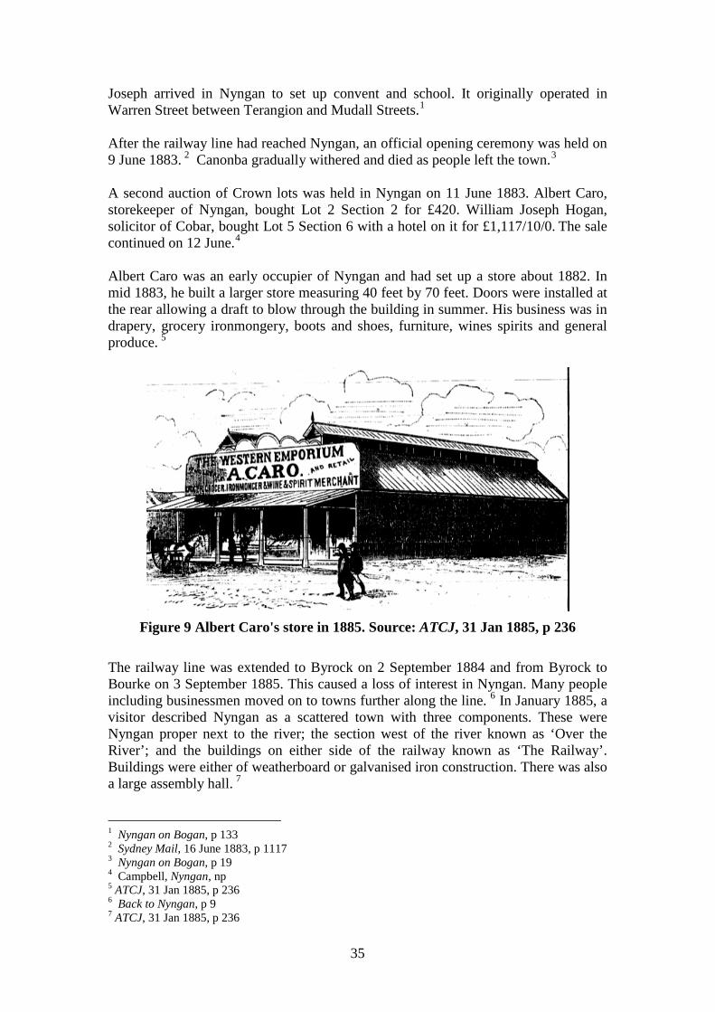
Joseph arrived in Nyngan to set up convent and school. It originally operated in Warren Street between Terangion and Mudall Streets.1 After the railway line had reached Nyngan, an official opening ceremony was held on 9 June 1883. 2 Canonba gradually withered and died as people left the town.3 A second auction of Crown lots was held in Nyngan on 11 June 1883. Albert Caro, storekeeper of Nyngan, bought Lot 2 Section 2 for £420. William Joseph Hogan, solicitor of Cobar, bought Lot 5 Section 6 with a hotel on it for £1,117/10/0. The sale continued on 12 June.4 Albert Caro was an early occupier of Nyngan and had set up a store about 1882. In mid 1883, he built a larger store measuring 40 feet by 70 feet. Doors were installed at the rear allowing a draft to blow through the building in summer. His business was in drapery, grocery ironmongery, boots and shoes, furniture, wines spirits and general produce. 5
Figure 9 Albert Caro's store in 1885. Source: ATCJ, 31 Jan 1885, p 236
The railway line was extended to Byrock on 2 September 1884 and from Byrock to Bourke on 3 September 1885. This caused a loss of interest in Nyngan. Many people including businessmen moved on to towns further along the line. 6 In January 1885, a visitor described Nyngan as a scattered town with three components. These were Nyngan proper next to the river; the section west of the river known as ‘Over the River’; and the buildings on either side of the railway known as ‘The Railway’. Buildings were either of weatherboard or galvanised iron construction. There was also a large assembly hall. 7 1 Nyngan on Bogan, p 133 2 Sydney Mail, 16 June 1883, p 1117 3 Nyngan on Bogan, p 19 4 Campbell, Nyngan, np 5 ATCJ, 31 Jan 1885, p 236 6 Back to Nyngan, p 9 7 ATCJ, 31 Jan 1885, p 236
36
After the vigorous growth of the town and its businesses, the pace of change quietened down. Businesses were still established and stores changed hands though the sequence of change was more serene. On 20 November 1888, Albert Caro leased his general store near the Bogan River to Arthur T Bleakley. Bleakley and Barringer bought the property on 1 June 1891.1 Bleakley and Barringer commenced a business that was an institution in Nyngan for decades. William Sharpe Brown moved his business from Girilambone to begin a general store near the river at Nyngan in 1889. He later moved to Panjee Street. In 1917, the business was sold to Albert Duke, who enlarged the store. Duke died in 1936 but his daughter Muriel Carter carried on until the business was sold to W Mailer in 1964.2 Chinese residents were also living at Nyngan. Hop Sing’s Special Lease for 1 acre 3 roods for a vegetable garden at Nyngan commenced for a term of five years commenced from 1 January 1889.3 In November 1889, a purpose-built Post Office built by D McDonald opened in Cobar Street next to the former redwood Post Office. The old building was sold for £45.4 A sign of the maturity of Nyngan as a settlement was the establishment of the Municipality of Nyngan proclaimed on 17 February 1891. The new Municipality had a population of 1,355 and 315 dwellings, of which 200 were of wooden slab construction and 23 were of brick.5 The opening of the branch rail line from Nyngan Junction to Cobar on 1 July 1892 gave another spurt to town development. As a junction, Nyngan was often very busy when trains or mail arrived. 6 It started a new boom in Nyngan, which created the core of the future town. 7 Nevertheless, the town population only rose from 1,355 in 1891 to 1,455 in 1901. By 1892, John Nelson was conducting the Carrier’s Arms Hotel in Nymagee Street.8 About 1893, Thomas Gregson built the Metropolitan Hotel by shifting a building from Girilambone. After Gregson, George Callan was licensee. It was later sold to Bleakley and Barringer. Mrs Stevens bought the corner at Pangee and Mudall Streets where a store was later built.9 In 1893, F Putenson erected a corner building for James Gale. A butcher, a bank and a shop operated on the site.10 A minor boom in subdivision after the rail line to Cobar opened occurred. In June 1893, a subdivision of part of Section 33, Nyngan was completed. The plan showed a blacksmith’s shop facing Wambiana Street east of Terangion Street.11 A subdivision 1 Lot 2 Section 2, C T 687 f 229 2 Nyngan on Bogan, p 150-1 3 NSWGG, 8 July 1890, p 5254 4 Nyngan on Bogan, p 89 5 Campbell, Nyngan, np 6 Nyngan on Bogan, p 204 7 Back to Nyngan, p 9 8 Nyngan on Bogan, p 137 9 Nyngan on Bogan, p 143 10 Nyngan on Bogan, p 221 11 DP 3006
37
of part of Sections 8 and 9 between Pangee, Dalton, Cannonbar, and Hoskins Streets in September 1893 included an iron house in the centre of Section 8.1 Suburban lot 3 Section 13 south-west of Oxley and Terangion Streets was subdivided in 1895 creating the current Collins Street.2 One of the most impressive signs of the boom was the construction of a new general store at the corner of Pangee and Tabratong Streets by A T Bleakley and Frank Page Barringer on the site of the old Metropolitan Hotel in 1894. When Bleakley drowned that year Barringer continued the business on his own. It became major store in Nyngan. 3 Arthur Bleakley drowned at Coogee on 5 January 1896 when trying to swim to shore from a boat experiencing difficulties in the water.4 His estate at Nyngan included the house he occupied on Lot 10 Section 6 in Monagee and Cobar Streets worth £200, the partners’ old store, which was then vacant on Lot 2 Section 2, Nyngan Street worth £225 and their new brick store at the corner of Tabratong and Panjee Streets (Lot 10 Section 32) worth £2,500. Two Conditional Purchases near Cobar were worth £60 and £500. When his debts and the share of his partner F P Barringer were deducted, Bleakley’s estate was worth £4,188, making him a wealthy man by the standards of that time.5 Like many parts of inland Australia, Bogan Shire has been adversely affected by droughts. A major drought of 1964-66 had a significant impact.6 The water supply had to be replenished by the release of water from the Fish River Dam and Chifley Dam.7 A number of floods have affected the district. The flatness of the landscape has enhanced the destructive impact. There have been floods at Nyngan in 1890, 1925, 1928, 1950, and January 1975.8 However, it was the Nyngan flood of 24 April 1990 that not only caused the evacuation of the whole town but the one that has become a major milestone in the history of the settlement.
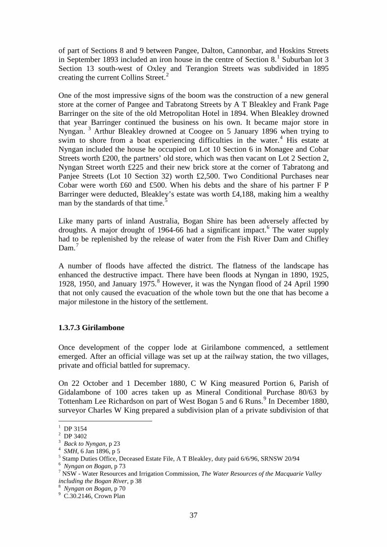
1.3.7.3 Girilambone Once development of the copper lode at Girilambone commenced, a settlement emerged. After an official village was set up at the railway station, the two villages, private and official battled for supremacy. On 22 October and 1 December 1880, C W King measured Portion 6, Parish of Gidalambone of 100 acres taken up as Mineral Conditional Purchase 80/63 by Tottenham Lee Richardson on part of West Bogan 5 and 6 Runs.9 In December 1880, surveyor Charles W King prepared a subdivision plan of a private subdivision of that 1 DP 3154 2 DP 3402 3 Back to Nyngan, p 23 4 SMH, 6 Jan 1896, p 5 5 Stamp Duties Office, Deceased Estate File, A T Bleakley, duty paid 6/6/96, SRNSW 20/94 6 Nyngan on Bogan, p 73 7 NSW - Water Resources and Irrigation Commission, The Water Resources of the Macquarie Valley including the Bogan River, p 38 8 Nyngan on Bogan, p 70 9 C.30.2146, Crown Plan
38
land at Girilambone, close to the mines that had been granted to the mine owner T L Richardson. It became the mine village.1 On 27 July 1882, Portion 6 parish of Gidalambone of 100 acres was granted to Tottenham Lee Richardson for £200. After it was subdivided as DP 986 some lots were sold. Lots 4 and 7 Section 2 were sold to Adam Adams. Lot 9 Section 1 was sold to George Buist. Lot 4 Section 10 was sold to Julius Caro whilst William Nicholas Willis bought lot 1 Section 1 and lot 8 Section 3.2 Once, the government town was created, the private town fell into disuse. Adams’ lots were not transferred again until 1991 and there is a similar tale for Buist’s lot.3 After mortgaging the residue of that grant to the Australian Joint Stock Bank, Richardson finally lost it in March 1897 when the bank sold it.4 Retail services arrived notably the store conducted by the partnership of Stephen Sullivan and W N Willis trading as ‘Sullivan and Willis’. By April 1882, Willis had left the joint venture and moved on to Nyngan.5 By February 1884, the Mercantile Bank of Sydney was advertising it had branches at Nyngan and Girilambone.6 Government provided other services. In April 1881, the residents of the village petitioned the Postmaster-General for postal services at Girilambone. Subsequently, Stephen Sullivan, partner of W N Willis in their store business commenced duty as postmaster on 1 August 1881.7 On 31 October 1881, residents also petitioned for a school. The school file recorded that the school commenced at Girilambone on 18 January 1882.8 It was later known as the Girilambone Mine Public School after a new school opened in the government town at the railway in July 1897. The mine school closed in October 1904. 9 Girilambone was gazetted as a place for petty sessions on 21 November 1882 but this role was abolished on 7 September 1886.10
1 Charles W King, Plan of the Town of Girilambone Being the subdivision of Portions No 6, 7, and 8, 1880, ML Map M3 816.219/GIRILAMBONE/1880/1 2 C T 591 f 105 3 C T 644 f 162; C T 644 f 163 4 C T 947 f 69-70 5 81/10613, Post Office File, NAA, CRS SP 32/1, Girilambone, 1876-1883, pt 1 6 SMH, 7 Feb 1884, p 4 7 81/7630, Post Office File, NAA, CRS SP 32/1, Girilambone, 1876-1883, pt 1 8 Education, School File, Girilambone, 1881-1903, SRNSW 5/15993.2 9 NSW – Dept of School Education, Government Schools of New South Wales 1848 to 1993, Dept of School Education, 1993, Sydney, p 72 10 H Golder, High and Responsible Office: A History of the NSW Magistracy, Sydney University Press, Sydney, 1991, p 238
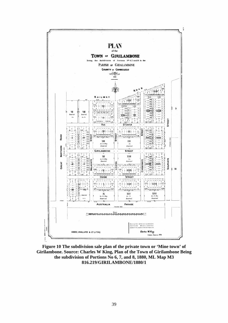
39
Figure 10 The subdivision sale plan of the private town or ‘Mine town’ of
Girilambone. Source: Charles W King, Plan of the Town of Girilambone Being the subdivision of Portions No 6, 7, and 8, 1880, ML Map M3
816.219/GIRILAMBONE/1880/1
40
A site for a government village at Girilambone was reserved on 18 February 1884 near the railway station.1 On 7 June 1884, a crown land sale offered lots in the government Village of Girilambone.2 In time, it drew all settlement away from the private town. Storekeepers and others who had bought lots in the private town gradually abandoned them. Some moved to the government town but many such as George Buist and Adam Adams shifted to Nyngan once it came into being. William Sharpe Brown who commenced business at Girilambone in 1886 moved to Nyngan in 1889. 3 The 1891 Census showed Girilambone with a population of 162 living in 34 habitations.4 A new Public School commenced at Girilambone in the government town at the railway in July 1897. The former school at the private town became known as Girilambone Mine Public School. 5 Girilambone was again gazetted as a place for holding petty sessions on 10 November 1899. 6 Since 1896, a mounted policeman had been stationed at Girilambone. In 1899, a Police station and lock-up was erected at Girilambone at a cost of £848.7 On 30 August 1925, a former shop from Cobar that had been erected at Girilambone as St Paul’s Anglican Church held its first service.8 The 1933 Census showed the population of Girilambone as 156 with another 136 people in the surrounding area.9 From 30 September 1970, petty sessions trials were no longer site held at Girilambone.10 The police station closed in 1975.11
1.3.7.4 Hermidale A Provisional school opened at Hermidale in May 1901 being elevated to a public school in October 1901.12 R A Sorenson found a copper lode in Parish Hermitage, County Canbelego in 1906. There were great expectations that the lode would be very profitable. Soon 108 lease applications had been received by the Department of Mines. Companies were floated to mine them but only the original lode proved to be profitable since it was an isolated outcrop.13
1 NSWGG, 18 Feb 1884, p 1232 2 SMH, 4 June 1884, p 13 3 Nyngan on Bogan, p 231 4 1891 Census, p 540 5 NSW – Dept of School Education, Government Schools of New South Wales 1848 to 1993, Dept of School Education, 1993, Sydney, p 71 6 H Golder, High and Responsible Office: A History of the NSW Magistracy, Sydney University Press, Sydney, 1991, p 238 7 K H Heckendorf, Girilambone 100 Years, Dubbo Secretarial Services, Dubbo, Oct 1980, p 51 8 Nyngan on Bogan, p 128 9 Premiers Department, Macquarie Region, p 33 10 H Golder, High and Responsible Office: A History of the NSW Magistracy, Sydney University Press, Sydney, 1991, p 238 11 K H Heckendorf, Girilambone 100 Years, Dubbo Secretarial Services, Dubbo, Oct 1980, p 52 12 NSW – Dept of School Education, Government Schools of New South Wales 1848 to 1993, Dept of School Education, 1993, Sydney, p 80 13 J E Carne, Copper-Mining Industry, 1908, p 194-5, 247
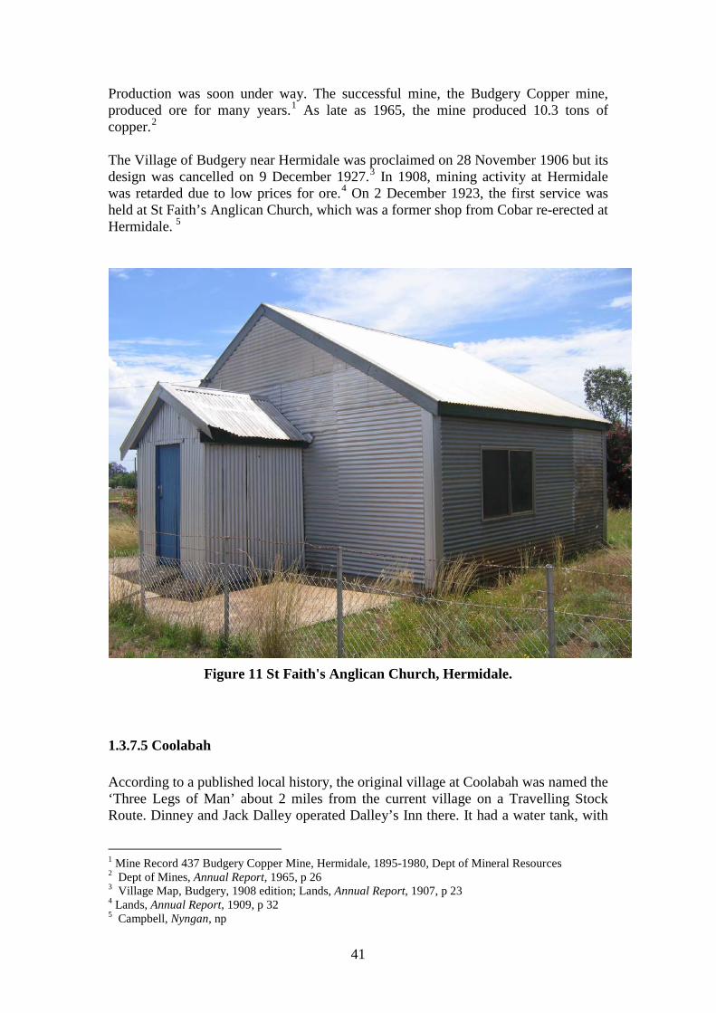
41
Production was soon under way. The successful mine, the Budgery Copper mine, produced ore for many years.1 As late as 1965, the mine produced 10.3 tons of copper.2 The Village of Budgery near Hermidale was proclaimed on 28 November 1906 but its design was cancelled on 9 December 1927.3 In 1908, mining activity at Hermidale was retarded due to low prices for ore.4 On 2 December 1923, the first service was held at St Faith’s Anglican Church, which was a former shop from Cobar re-erected at Hermidale. 5
Figure 11 St Faith's Anglican Church, Hermidale.
1.3.7.5 Coolabah According to a published local history, the original village at Coolabah was named the ‘Three Legs of Man’ about 2 miles from the current village on a Travelling Stock Route. Dinney and Jack Dalley operated Dalley’s Inn there. It had a water tank, with
1 Mine Record 437 Budgery Copper Mine, Hermidale, 1895-1980, Dept of Mineral Resources 2 Dept of Mines, Annual Report, 1965, p 26 3 Village Map, Budgery, 1908 edition; Lands, Annual Report, 1907, p 23 4 Lands, Annual Report, 1909, p 32 5 Campbell, Nyngan, np
42
cottages built around it. Chinese ringbarkers are believed to be buried near the inn. The Dalleys moved to the new village after business declined. One of their purchases was named Ballyhooley after their home village.1 Denis Dalley took up a Conditional Purchase of 320 acres in Parish Vega adjoining the future site of Coolabah Village on 2 November 1882. When surveyed on 26 September 1884, it had hut, yard and 600-yard tank.2 It is uncertain if this is the site of the former village. Originally, a railway camp called Cargo Road was located on the rail line. On 2 September 1884, the railway station opened at Coolabah and the name Coolabah was given to the village.3 Charles Werner built a hotel called ‘Three Legs O’Man Hotel’ after a former hotel he had owned on what became the main street of the new village at Coolabah when the railway arrived. It was situated on the block bounded by Bourke, Dalley, Werner and Budther Streets. He also built a huge water tank in the hotel yard with a galvanised iron roof. The hotel was sold to Henry Mortlock in 1895 and Amelia Fox on 1896. The hotel was demolished in the 1920s and the Coolibah Hotel was built on its site retaining the old two-storey brick house. The builder and designer was Albert Rosette. It burned down in 1968. 4 Charles Werner also set up a shop facing Bourke Street. 5 A postal receiving office opened at Coolabah with Charles Werner as postmaster in December 1884. It was elevated to a post office from 16 December 1885. 6 A hotel was built next to the Coolabah courthouse in Girilambone Street about 1890, but it was later destroyed by fire. It was owned by Rosenbert and was licensed to Albert Luke Britton.7 It was not until 14 August 1886 that the official site for the village at Coolabah was set aside.8 On 5 February 1887, Charles Werner bought various lots at Coolabah at the Crown Land Auction. The lots were granted on 26 May 1887. He transferred them to his mortgagees on 10 October 1892.9 Coolabah Provisional School opened in January 1887 becoming a Public School in October 1892.10 A new school building opened in October 1912 followed by a new school residence in May 1913.11 A police station had been established at Coolabah by 1891 when additions worth £309/12/6 were completed to the building.12 An Experimental Farm was operating at Coolabah by 1894. It is believed that William Farrer undertook some of his wheat
1 Simmonds, Cobb & Co, p 69 2 C.117.2146, Crown Plan 3 P Thompson, Under the shade of the Coolibah, p 1 4 P Thompson, Under the shade of the Coolibah, p 4-7 5 P Thompson, Under the shade of the Coolibah, p 8 6 P Thompson, Under the shade of the Coolibah, p 14 7 Simmonds, Cobb & Co, p 71 8 NSWGG, 14 Aug 1886, p 5541 9 C T 837 f 79 (also f 8-83) 10 NSW – Dept of School Education, Government Schools of New South Wales 1848 to 1993, Dept of School Education, 1993, Sydney, p 53 11 P Thompson, Under the shade of the Coolibah, p 22 12 NSW - Department of Public Works, Annual Report, 1891, p 100
43
breeding experiments there.1 Coolabah was gazetted as place for petty sessions on 13 December 1898 but it was abolished on 20 July 1905.2
1.3.7.6 Bobadah ‘Tindall’ found silver in the Black Range on The Overflow Pastoral Holding 187 Central in 1895. It became the ‘The Overflow’ Silver Mine operated by The Overflow Silver Mining Co (NL) and later The Overflow Mines (NL). By 1897, a cyanide plant was extracting silver from the ore.3 By October 1896, the Chief Inspector for Mines Mr Slee, had laid down a street west of Mineral Leases 1 and 2 for a town to be called Bobadah. He noted that it had been a meeting place, for Aborigines in the past. He had seen large numbers of flakes from manufacturing stone tools.4 Village Reserve No 25103 in the Parish of Cameron was notified on 4 November 1896 and 12 January 1897. Instructions to measure a town were issued about March 1897. In April 1897, surveyor H A D O’Connor journeyed to the mine to lay out the village of Carpina plus a road to the Condobolin to Nymagee road. There were 40 men employed at the mine.5 The Town of Carpina was proclaimed on 6 November 1897.6 It was more commonly known as Bobadah. On 5 February 1897, the Bobadah Progress Association requested the establishment of a post office. The mining company was expending large sums in setting up the mine, so the postal inspector felt it would become an ‘important centre’. On 5 April 1897, M F Hennessy commenced duty as postmaster.7 However, his store and post office burned down late in 1897.8 A public school opened in August 1897 and operated until it was downgraded to a provisional school in September 1919 before closing in May 1923.9 In 1898, construction of a police station commenced and it was complete by June 1900 at a cost of £441/10/0.10 Soon the company was mainly extracting gold. In 1900, the ore became too difficult to treat. Water jacket furnaces were installed. In 1914, production ceased. In 1935, Bobadah Development (N L) began operating at the mine but only produced ore intermittently.11 A Provisional School re-opened in May 1943, which was elevated to a Public School in November 1957, which operated until it closed in December 1972. 12
1 P Thompson, Under the shade of the Coolibah, p 42 2 H Golder, High and Responsible Office: A History of the NSW Magistracy, Sydney University Press, Sydney, 1991, p 235 3 Mine Record 449 Overflow Mine, Bobadah, 1894-1979, Dept of Mineral Resources 4 SMH, 16 Oct 1896, p 7 5 SMH, 12 April 1897, p 5 6 Parish Map, Parish Cameron, Co Flinders, 1895, Image 14126801, 14126701; Village Map, Carpina, 1897 edition 7 Post Office File, Bobadah Part 1, 1897-1901, NAA, CRS 32/1 8 SMH, 18 Dec 1897, p 9 9 NSW – Dept of School Education, Government Schools of New South Wales 1848 to 1993, Dept of School Education, 1993, Sydney, p 34 10 NSW - Department of Public Works, Annual Report, 1900, p 65 11 Mine Record 449 Overflow Mine, Bobadah, 1894-1979, Dept of Mineral Resources 12 NSW – Dept of School Education, Government Schools of New South Wales 1848 to 1993, Dept of School Education, 1993, Sydney, p 34
44
1.3.7.7 Miandetta Village Reserve No 24021 was notified at Miandetta siding on the railway line in Parish Coreen on 18 April 1896. Village lots were laid out.1 Mineral applications were made to mine for silver, copper and lead immediately north of the village in 1906 and 1907.2 The mine shaft of the Great Miandetta mine was down to 115 feet in June 1906. These mines appear to have been taken up as part of the speculative rush sparked by the Budgery Mine.3 By May 1907, a cross-cut shaft was being driven into the main lode at the Great Miandetta mine.4 However, the mine does not appear to have met the expectations of its investors and seems to have been abandoned about 1908.5 By 1903, John Thomas Priest and his family were operating the Miandetta sawmills.6 On 31 August 1905, William and Henry Priest registered their firm of saw millers at Miandetta.7 A Provisional School opened September 1912 and operated until May 1945.8 On 11 November 1915, surveyor Oscar Kruth measured Portions 10 to 19 Parish Coreen, County Canbelego, which was in effect the village of Miandetta. He showed existing buildings on his plan.9
1 Parish Map, Parish Coreen, Co Canbelego, 1921 2 Plans M.12605; M.12690, Dept of Mineral Resources 3 SMH, 25 June 1906 p 9 4 SMH, 10 May 1907 p 10 5 The Mine Record file terminates in 1908, and there are no further press reports after 1907. See Mine Record 433, Miandetta Mine, Hermidale, 1908, Dept of Mineral Resources 6 Australia, Electoral Rolls, 1903, Electoral District of Cobar, (Nyngan Division) 7 Registers of Firms, SRNSW 2/8538, No 14599 8 NSW – Dept of School Education, Government Schools of New South Wales 1848 to 1993, Dept of School Education, 1993, Sydney, p 101 9 C.355.2146, Crown Plan
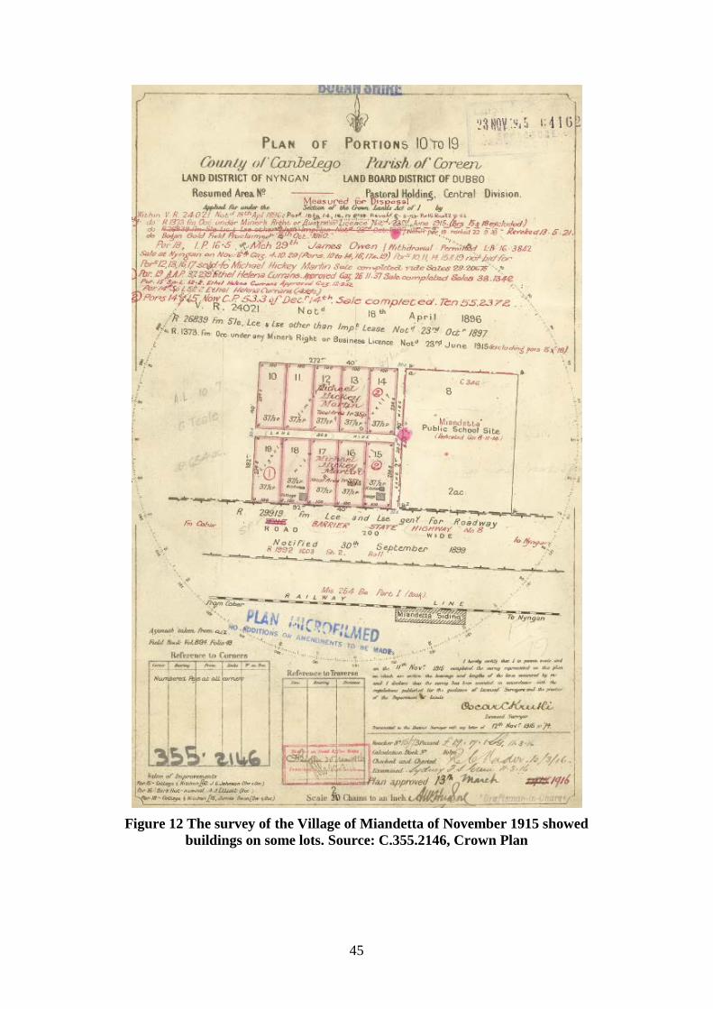
45
Figure 12 The survey of the Village of Miandetta of November 1915 showed
buildings on some lots. Source: C.355.2146, Crown Plan
46
1.3.8 Theme – Promoting closer settlement The 1861 Crown Lands Alienation Act opened the way for closer settlement but its success in breaking up squatters' leasehold estates varied from place to place. In some areas, it was not until the twentieth century that Closer Settlement was successful in creating a pattern of small farms across the district. Free selection also reduced opportunities for local Aborigines to survive on areas unoccupied by pastoralists or selectors. Many of the selections taken up in what is now Bogan Shire were being used by pastoral leaseholders to secure key parts of their runs, and by small businessmen such as innkeepers as a way of securing the land around their inn. Other selections were taken up along watercourses such as the Bogan River by hopeful agriculturalists. Almost all were soon absorbed by larger landholdings. Patrick Lynch, a run manager, took a Conditional Purchase on 40 acres west of the Bogan River in West Bogan No 1 run (Portion 1, Parish Lynch) in 1872. When surveyed on 1 November 1873 there were huts and a garden on the land.1 Robert Paton took up a Conditional Purchase of 40 acres Parish Bergo, north of the future site of Nyngan in 1874. He built the ‘Traveller's Rest’ Hotel on the land. 2 The survey plan of 4 September 1874 showed a ‘House and stables’.3 The local history by H E O Campbell identified a series of Conditional Purchases near Nyngan in 1881 by Francis and J T Dawson, George Foreman and Augustus Lyne.4 Not all of these can be identified, but the one taken by Augustus Lyne of Nyngan became Portion 5 Parish of Nyngan.5 Frank Simon took up 40 acres on the Bogan River (Portion 1, Parish Nyngan) on 7 December 1882. When surveyed on 5 October 1883, it had a hut and garden. 6 The surveyor was William Farrer who completed many of the surveys around Nyngan in the early 1880s. Conditional Purchases taken near Nyngan in 1883 included those by Walter Cooper, William Brotherton, and Peter Hanson. 7 Peter Waldemer Hansen took up 40 acres on 12 April 1883 now known as Portion 2, Parish of Nyngan.8 W Higgins and Eliza Duckett took up Conditional Purchases near Nyngan in 1884.9 William Higgins’ Conditional Purchases were for Portions 3 and 4, Parish of Nyngan, taken on 3 January 1884 and 8 May 1884.10
1 C.1.2146, Crown Plan 2 Campbell, Nyngan, np 3 G.77.1907, Crown Plan 4 Campbell, Nyngan, np 5 CP 81/403 Dubbo, Lands, Sales, Conditional Purchase Register, SRNSW 7/2898 6 C.278.2000, Crown Plan 7 Campbell, Nyngan, np 8 C.279.2000, Crown Plan 9 Campbell, Nyngan, np 10 C.297.2000, Crown Plan
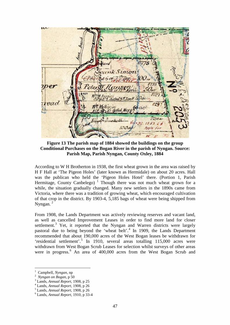
47
Figure 13 The parish map of 1884 showed the buildings on the group
Conditional Purchases on the Bogan River in the parish of Nyngan. Source: Parish Map, Parish Nyngan, County Oxley, 1884
According to W H Brotherton in 1938, the first wheat grown in the area was raised by H F Hall at ‘The Pigeon Holes’ (later known as Hermidale) on about 20 acres. Hall was the publican who held the ‘Pigeon Holes Hotel’ there. (Portion 1, Parish Hermitage, County Canbelego) 1 Though there was not much wheat grown for a while, the situation gradually changed. Many new settlers in the 1890s came from Victoria, where there was a tradition of growing wheat, which encouraged cultivation of that crop in the district. By 1903-4, 5,185 bags of wheat were being shipped from Nyngan. 2 From 1908, the Lands Department was actively reviewing reserves and vacant land, as well as cancelled Improvement Leases in order to find more land for closer settlement.3 Yet, it reported that the Nyngan and Warren districts were largely pastoral due to being beyond the ‘wheat belt’.4 In 1909, the Lands Department recommended that about 190,000 acres of the West Bogan leases be withdrawn for ‘residential settlement’.5 In 1910, several areas totalling 115,000 acres were withdrawn from West Bogan Scrub Leases for selection whilst surveys of other areas were in progress.6 An area of 400,000 acres from the West Bogan Scrub and
1 Campbell, Nyngan, np 2 Nyngan on Bogan, p 50 3 Lands, Annual Report, 1908, p 25 4 Lands, Annual Report, 1908, p 26 5 Lands, Annual Report, 1908, p 26 6 Lands, Annual Report, 1910, p 33-4
48
Improvement Leases were referred to the Reserves Revision Board in 1911 for disposal as Settlement Leases.1 An area of 597,914 acres of Scrub and Improvement Leases west of Bogan River had been topographically surveyed by 1915 for consideration by the Closer Settlement Advisory Board for closer settlement. 2 A further area of 86,420 acres of Scrub and Improvement Leases west of Bogan River was topographically surveyed in 1916 for consideration for closer settlement.3 Additionally after World War 1, large parts of Canonbar were acquired for soldier settlement blocks leaving the station with 7,000 acres, covering Miowera, Box Cowal and Fairview.4 A new wing was added to Nyngan Public School in 1924 due to the larger population brought by closer settlement.5 Larger holdings were resumed or came into the hands of new owners. The Matchett family sold Mullengudgery and Murrawombie to Moxham brothers in 1927. Murrawombie was later resumed by crown for closer settlement.6 In 1928, Honeybugle Station owned by Goldsbrough Mort & Co and John Brown was divided into 16 blocks for ballot. Richard Hoare from Victoria was one of the successful applicants. His property was known as Karabarn.7 By 1928 as well, the former Improvement Leases were expiring in Bogan Shire. They were replaced by smaller holdings of Homestead Selections.8 By 1922, Wilfred Gibson was growing wheat on his property Mulla, 22 miles from Nyngan and was producing enough to sell by 1926. Yet wheat did not become a major crop until forty years later.9 The early 1960s saw major expansion of wheat growing across the area after varieties suited to dry conditions had been developed.10 Despite the marginal nature of the area, integrated wool and wheat growing also increased.11 By 1966, it had been ascertained that the soils of the Bogan below Nyngan were not suited for irrigation.12 Hence, the future of the Shire was in dryland farming. From 1965 onwards, high demand for wheat growing lands ensured the clearing of mallee, bimble box and white cypress pine from the country west of the Bogan River.13 In the late 1990s, agriculture diversified in part into small piggeries, cattle feedlot production and emu and ostrich faming. 14 By 2008, olive growing was a new primary industry in shire.15 ‘Benah’ is one of the properties now growing olives. 1 Lands, Annual Report, 1911, p 41 2 Lands, Annual Report, 1915, p 33 3 Lands, Annual Report, 1916, p 35 4 Nyngan on Bogan, p 27 5 Back to Nyngan, p 16 6 Nyngan on Bogan, p 62 7 Nyngan on Bogan, p 218 8 Back to Nyngan, p 15 9 Nyngan on Bogan, p 245 10 Nyngan on Bogan, p 50 11 Bogan Shire Council, Annual Report, 2000-1, Environment Report, p 1 12 NSW - Water Resources and Irrigation Commission, The Water Resources of the Macquarie Valley including the Bogan River, p 45 13 D Shelly, Flora and Fauna of Coolabah District, p 12 14 Bogan Shire Council, Annual Report, 2000-1, Environment Report, p 1 15 Bogan Shire Council, Community Plan, 2008-9, p 20
49
1.3.9 Theme - Altering the landscape The process of introducing new species and animals onto the lands of the Bogan ensured significant changes to the vegetation, soils and wildlife of the region. In 1879, according to W H Brotherton, the first station to be ring-barked in the Nyngan district was Budgery near Hermidale.1 Despite some early clearing, the removal of Aboriginal fire regimes allowed scrub to re-invade areas that had been clear when the land was taken up by pastoralists. By 1895, the spread of pine and box seedling scrub west of the Bogan River had considerably reduced the area available to lessees of runs. The lessees approached the Minister for Lands seeking some arrangement to reduce their rents or assist them to clear the scrub.2 The result was a programme of using the unemployed to clear the scrub. Utilisation of former billabongs and effluent channels as water storages has created a number of artificial wetlands along the river. In the Nyngan area, the only wetland that is permanent is the artificial water storage at Nyngan providing town water for Nyngan and Cobar, maintained by releases from the Macquarie River. Other creeks such as Duck and Crooked Creeks have been altered by regular water flows so that the channels have become lined with cumbungi.3 From 1965 onwards, high demand for wheat ensured the clearing of mallee, bimble box and white cypress pine from country west of the Bogan River to grow grain crops.4 From 2000 onwards, the growing of cotton crops near the Albert Channel was posing a risk of contamination but drought conditions prevented it becoming a problem.5
1 Campbell, Nyngan, np 2 ‘Crown Lands (Proposals with respect to the conversion of certain pastoral leases … Land Board District of Dubbo …)’, V & P L A N S W, 1895, volume 3, pp 123-4 3 NSW – Dept of Water Resources, Water Resources of the Castlereagh, Macquarie and Bogan valleys, Dept, Parramatta 1991, p 28-9 4 D Shelly, Flora and Fauna of Coolabah District, p 12 5 Bogan Shire Council, Annual Report, 2008-9, np
50
1.4 Contextual Essay – Working
1.4.1 Theme - Working the land Work ranges from professional occupations through commercial activities with their own special forms of knowledge and expertise, notably in small business, through to the skilled, semi-skilled and unskilled. Even ostensibly ‘unskilled’ jobs, such as horse breaking, droving or as a general hand on a property had their distinct sets of special knowledge. For the bulk of the population in the nineteenth and early twentieth century, employment was uncertain, particularly in rural areas. There were few permanent positions available. The Australian economy was dependent on overseas demand for its rural products. A large floating casual workforce was a feature of life in the Australian colonies. Men drifted in search of work, sometimes with their families and often without. As the nineteenth century drew to a close, more common was the drifting pool of casual labourers who worked at shearing, labouring and any job that they could get, both in town and country. Evidence of their work remains in the form of shearers’ quarters, woolsheds and shearing sheds. Many of them are no longer in use due to the shift from raising sheep for meat rather than wool.
1.4.2 Theme – Working in town Except for Nyngan most of the urban places or villages of the shire were small centres offering only basic services. Only Nyngan had a wide range of occupations. Despite its service and retail functions, and being the main centre of the district by the twentieth century, its occupational composition was not just a reflection of its role offering things for sale. As a major junction, railway employment was significant for the town. In 1903, many residents of Nyngan were railway employees such as shunters, fuelmen, firemen, porters and even a signal-fitter and the locomotive foreman David Howell. Apart from them, there were numerous labourers, many of whom would have worked shifting goods when trains were loaded or unloaded. Fettlers lived along the length of the line. Additionally, the elite employees of the railway department, engine drivers also lived at Nyngan such as Adolphus Beverley, John Brand, George Fisher and William Smith.1 Other employment was focussed on manufacturing (see below) or in retailing and services. For further information see Section 1.6.5 below.
1 Australia, Electoral Roll, 1903, Electoral District of Cobar, Nyngan Division
51
1.4.3 Theme - Manufacturing – working in workshops, mills or factories Manufacturing can be divided into those activities which processed rural raw materials, some of them associated with food such as slaughter yards or mills; or workshop style production where the employer or owner worked on the floor with his employees and with no more than 5 to 10 employees; or large ‘factory' style enterprises. The first two types of enterprise were found in Bogan Shire but not large factory style operations. Rural processing industries are often the first to commence in any newly settled district and Bogan Shire was no exception. Martin Kerz operated a sawmill at Girilambone supplying the copper mines at Girilambone and Cobar in the 1870s. 1 Food processing was the most notable activity, mostly for local consumption but there were firms that produced for a wider market. The most significant of these was the Warrigal meatworks. In 1890, the Nyngan Meat Preserving and Boiling Down Co was set up by James and Alexander Davidson and George Cromack of Sydney on land bought from John Robinson of Woodlands. Since it was next to the Warrigal Rail siding, it became known as the ‘Warrigal’.2 In 1908, the Nyngan Meat Preserving and Boiling Down Co was reconstituted as The Nyngan Refrigerating and Boiling Down Co, which mainly processed rabbits. It also made large quantities of ice for local consumption.3 From 1960 to 1970, the former Warrigal meat works, owned by Arnold Brooksby, processed kangaroo meat for export to Germany and Japan and for local pet food.4 There were originally twelve cottages for employees. By 1983, a large brick building plus two or three old cottages were still on site. 5 The Nyngan Brewery on Bogan Road was operated from 1892 to 1897 by Peter Crane, with James Howieson as brewer. In 1893, it was sold to Donald Sanderson and W M Connell who sold it to J Sloane in 1895.6 Harry Ellis and Donald Sanderson had a brewery on the river near the waterworks and Golf Links Paddock.7 In 22 December 1892, there were three cordial makers in Nyngan: John McMillan, Nyngan Street (later Sloane’s Cordials); John White, Ford Street; and Peter Crane, Nymagee Street.8 The Bee-Tree Wool Scour owned by J N Moffat was located on the Bogan River operated by J E Joubert was handling 180 bales per week in 1892. 9 On 12 January 1894, a court case was heard against J E Joubert, operator of the wool scour, described as being two miles down the Bogan River from Nyngan, for polluting the river. Selectors James Hemphill, J B Eather and James Gale had brought the case.10 The woolscour appears to have been located on Portion 80 Parish Bergo, County
1 Nyngan on Bogan, p 38 2 Nyngan on Bogan, p 47-8 3 Nyngan on Bogan, p 47 4 Nyngan on Bogan, p 49; 5 Nyngan on Bogan, p 47-8 6 K M Deutsher, The Breweries of Australia: A History, Lothian, Melbourne, 1999, p 55 7 Nyngan on Bogan, p 143 8 Campbell, Nyngan, np 9 Campbell, Nyngan, np 10 SMH, 13 Jan 1894, p 5
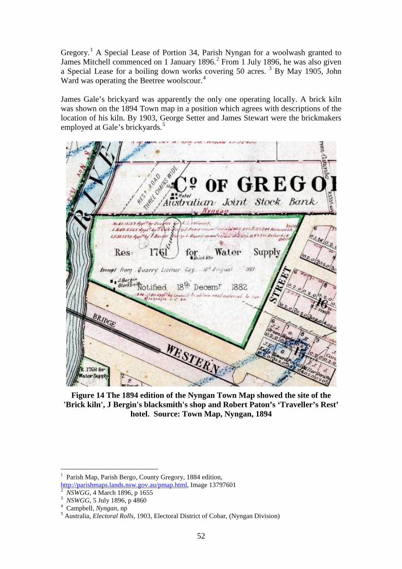
52
Gregory.1 A Special Lease of Portion 34, Parish Nyngan for a woolwash granted to James Mitchell commenced on 1 January 1896.2 From 1 July 1896, he was also given a Special Lease for a boiling down works covering 50 acres. 3 By May 1905, John Ward was operating the Beetree woolscour.4 James Gale’s brickyard was apparently the only one operating locally. A brick kiln was shown on the 1894 Town map in a position which agrees with descriptions of the location of his kiln. By 1903, George Setter and James Stewart were the brickmakers employed at Gale’s brickyards.5
Figure 14 The 1894 edition of the Nyngan Town Map showed the site of the
'Brick kiln', J Bergin's blacksmith's shop and Robert Paton’s ‘Traveller’s Rest’ hotel. Source: Town Map, Nyngan, 1894
1 Parish Map, Parish Bergo, County Gregory, 1884 edition, http://parishmaps.lands.nsw.gov.au/pmap.html, Image 13797601 2 NSWGG, 4 March 1896, p 1655 3 NSWGG, 5 July 1896, p 4860 4 Campbell, Nyngan, np 5 Australia, Electoral Rolls, 1903, Electoral District of Cobar, (Nyngan Division)
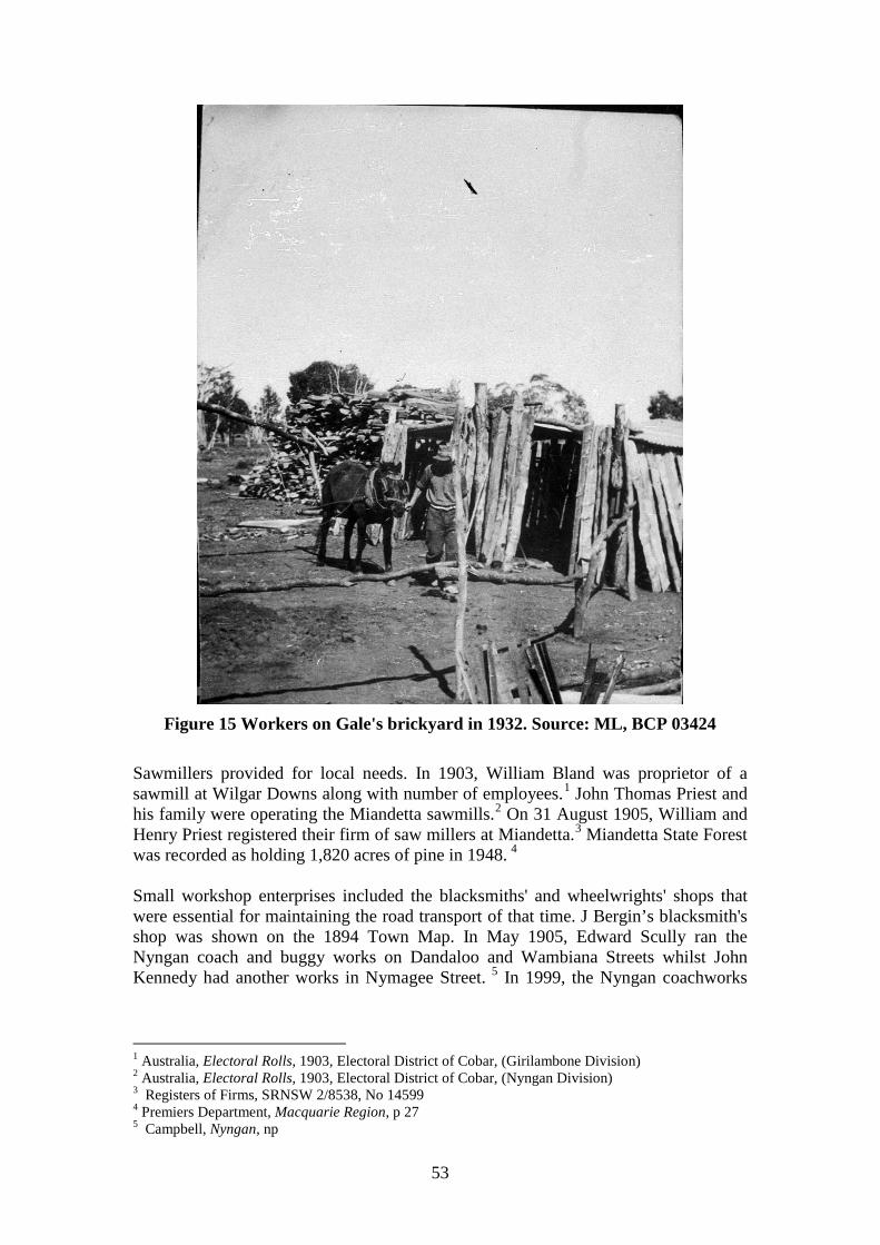
53
Figure 15 Workers on Gale's brickyard in 1932. Source: ML, BCP 03424
Sawmillers provided for local needs. In 1903, William Bland was proprietor of a sawmill at Wilgar Downs along with number of employees.1 John Thomas Priest and his family were operating the Miandetta sawmills.2 On 31 August 1905, William and Henry Priest registered their firm of saw millers at Miandetta.3 Miandetta State Forest was recorded as holding 1,820 acres of pine in 1948. 4 Small workshop enterprises included the blacksmiths' and wheelwrights' shops that were essential for maintaining the road transport of that time. J Bergin’s blacksmith's shop was shown on the 1894 Town Map. In May 1905, Edward Scully ran the Nyngan coach and buggy works on Dandaloo and Wambiana Streets whilst John Kennedy had another works in Nymagee Street. 5 In 1999, the Nyngan coachworks
1 Australia, Electoral Rolls, 1903, Electoral District of Cobar, (Girilambone Division) 2 Australia, Electoral Rolls, 1903, Electoral District of Cobar, (Nyngan Division) 3 Registers of Firms, SRNSW 2/8538, No 14599 4 Premiers Department, Macquarie Region, p 27 5 Campbell, Nyngan, np
54
operated by Don Burns was situated at the corner of Moonagee and Nymagee Streets.1 In 1945, the only manufacturing works in Nyngan were the cordial factory operated by W E Chaney whilst the Warrigal Cold Stores offered cold storage. The Observer had printing presses.2
1 Simmonds, Cobb & Co, p 68 2 Premiers Department, Macquarie Region, p 32
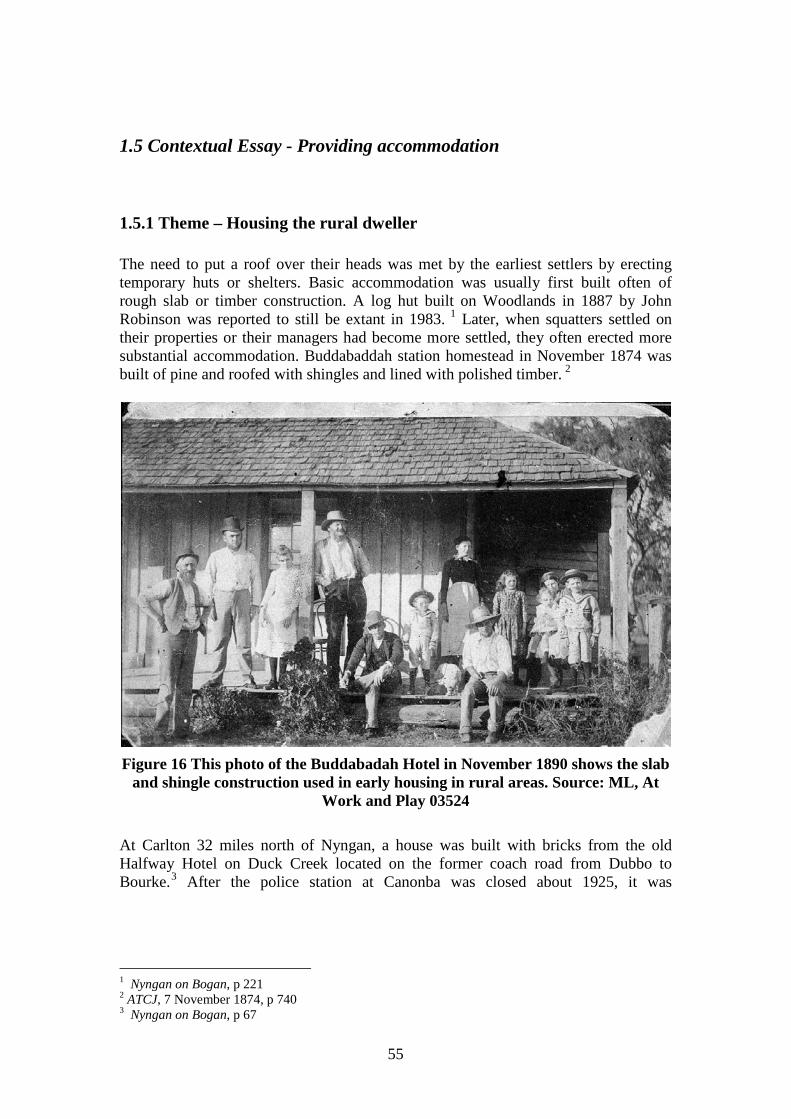
55
1.5 Contextual Essay - Providing accommodation
1.5.1 Theme – Housing the rural dweller The need to put a roof over their heads was met by the earliest settlers by erecting temporary huts or shelters. Basic accommodation was usually first built often of rough slab or timber construction. A log hut built on Woodlands in 1887 by John Robinson was reported to still be extant in 1983. 1 Later, when squatters settled on their properties or their managers had become more settled, they often erected more substantial accommodation. Buddabaddah station homestead in November 1874 was built of pine and roofed with shingles and lined with polished timber. 2
Figure 16 This photo of the Buddabadah Hotel in November 1890 shows the slab
and shingle construction used in early housing in rural areas. Source: ML, At Work and Play 03524
At Carlton 32 miles north of Nyngan, a house was built with bricks from the old Halfway Hotel on Duck Creek located on the former coach road from Dubbo to Bourke.3 After the police station at Canonba was closed about 1925, it was
1 Nyngan on Bogan, p 221 2 ATCJ, 7 November 1874, p 740 3 Nyngan on Bogan, p 67
56
demolished by J W Garland of Benah after he bought the land.1 The bricks were used to build Benah homestead.2 From 1906, the bulk of rural housing was of timber wall construction, with a modest few of brick. From the late 1940s onwards, fibro houses became a much substantial part of the total. A sizeable part of the rural housing in Bogan Shire was built with metal walls most likely galvanised iron. Dwellings in Bogan Shire 1911-1961 Bogan Shire 1911 1921 1933 1947 1954 1961 Brick or stone Stone 1 2 1 1 Brick 2 2 6 8 9 Concrete, adobe, pise 1 2 5 7 Metal 32 71 31 31 37 WB slab or inferior 280 264 233 219 214 Sundried Bricks Pise 1 2 1 Lath, Wattle, Mud 1 1 Fibro 36 58 118 181 Rooms Tents 44 33 29 22 12 Drays Ships Other 1 1 10 5 Unknown 2 3 1 1 Total dwellings 365 414 362 415 466 476 Source: Census, 1911-1961
1.5.2 Theme – Housing the town or village dweller A similar pattern occurred in Canonba and Nyngan with rough shelter being replaced as need or opportunity permitted with houses of milled timber or of brick. In June 1888, the only brick buildings in Nyngan were the railway station, workshops and the railway workers' cottages.3 Those railway cottages appear to be those that still survive in a perilous condition on Pangee Street between the station and Moonagee Street.
1 Nyngan on Bogan, p 111 2 Simmonds, Cobb & Co, p 72 3 ATCJ, 2 June 1888, p 1123
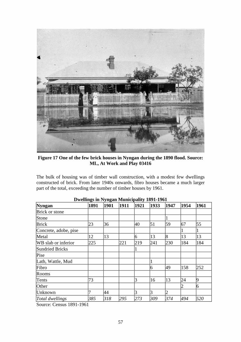
57
Figure 17 One of the few brick houses in Nyngan during the 1890 flood. Source:
ML, At Work and Play 03416 The bulk of housing was of timber wall construction, with a modest few dwellings constructed of brick. From later 1940s onwards, fibro houses became a much larger part of the total, exceeding the number of timber houses by 1961.
Dwellings in Nyngan Municipality 1891-1961 Nyngan 1891 1901 1911 1921 1933 1947 1954 1961 Brick or stone Stone 1 Brick 23 36 40 51 59 67 55 Concrete, adobe, pise 1 1 Metal 12 13 6 13 8 13 13 WB slab or inferior 225 221 219 241 230 184 184 Sundried Bricks 1 Pise Lath, Wattle, Mud 1 Fibro 6 49 158 252 Rooms Tents 73 3 16 13 24 9 Other 2 6 Unknown 7 44 3 3 2 Total dwellings 385 318 295 273 309 374 494 520 Source: Census 1891-1961
58
Accommodation was built as family homes for those who lived and worked in the area, either for the railway or for the businesses in town. Many would have rented their accommodation. For the roving rural worker or those who needed temporary accommodation whilst working in town, boarding houses or lodging houses provided shelter. By 1904, a former boarding house in Nymagee Street was run by Mrs Bell. After Thomas Ryan bought it, it became the Australian Hotel.1 On 10 September 1936, there was a major fire in the ‘Bushmen’s Home’ a weatherboard building with 15 rooms at the corner of Nymagee and Tabratong Streets that was run as a boarding house by Christopher O’Toole. 2 Timber houses were also moved easily once settlement patterns changed. A large cottage in Terangion Street, Nyngan occupied by Jack Walsh in 1938 was a former hotel from Canonbar.3 Other houses appear to have been pre-fabricated cottages, such as 16 Cannonbar Street and 9 Derrybong Street, possibly dating back to the late nineteenth or early twentieth century. The Wartime Housing Survey of 1943-44 showed that of a total of 360 dwelling units in Nyngan, 25 were sub-standard and should be demolished. Another fifty more were capable of renovation. None of Bogan Shire's houses were rated so poorly. 4 As in all towns largely built of timber, fire was a major hazard as well as significant determinant of building survival. A major fire in Nymagee Street on 28 March 1948 destroyed a number of houses.5 More recent mining development has allowed the shire to grow modestly. From 1 July 2007 to 30 June 2008, there were building applications for a total of ‘five (4) dwellings’ [sic], 31 additions, and two other residential developments including duplexes or units.6
1 Nyngan on Bogan, p 137, 143 2 Nyngan on Bogan, p 126 3 Campbell, Nyngan, np 4 Premiers Department, Macquarie Region, p 38 5 Nyngan on Bogan, p 126 6 Bogan Shire Council, Annual Report, 2008-9, np
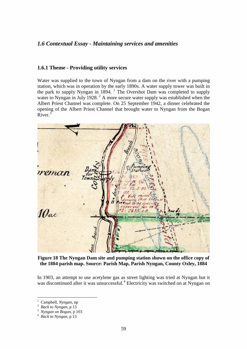
59
1.6 Contextual Essay - Maintaining services and amenities
1.6.1 Theme - Providing utility services Water was supplied to the town of Nyngan from a dam on the river with a pumping station, which was in operation by the early 1890s. A water supply tower was built in the park to supply Nyngan in 1894. 1 The Overshot Dam was completed to supply water to Nyngan in July 1928. 2 A more secure water supply was established when the Albert Priest Channel was complete. On 25 September 1942, a dinner celebrated the opening of the Albert Priest Channel that brought water to Nyngan from the Bogan River.3
Figure 18 The Nyngan Dam site and pumping station shown on the office copy of the 1884 parish map. Source: Parish Map, Parish Nyngan, County Oxley, 1884
In 1903, an attempt to use acetylene gas as street lighting was tried at Nyngan but it was discontinued after it was unsuccessful.4 Electricity was switched on at Nyngan on
1 Campbell, Nyngan, np 2 Back to Nyngan, p 13 3 Nyngan on Bogan, p 103 4 Back to Nyngan, p 13
60
28 June 1926. 1 The power station was situated in a plant behind the Town Hall. It was also used to pump greater volumes of water from the river. 2 A Volunteer Fire Brigade was formed at Nyngan on 18 February 1935. 3 The Fire Station opened on 12 December 1935.4 A sewerage system for Nyngan was officially opened on 27 November 1959. 5
1.6.2 Theme – Communicating The earliest mail run to Canonba from Dubbo to Canonba via Warren commenced in 1858. 6 By June 1858, H J W Egan was postmaster at Canonba.7 After the house at Colane station burned down about 1860 a new one was built half a mile from the old one. It had a post office adjacent.8 On 16 September 1880, a post office commenced at Thomas Rowe’s Tattersall’s Hotel, Nyngan.9 On 21 August 1882, the Nyngan Post Office opened in H V Jackson’s general store.10 In November 1889, a purpose-built Post Office built by D McDonald opened in Cobar Street.11 The telegraph office opened at Nyngan Railway Station on 8 June 1883.12 A postal receiving office opened at Coolabah with Charles Werner as postmaster in December 1884. It was elevated to a post office from 16 December 1885.13 On 5 February 1897, the Bobadah Progress Association requested the establishment of a post office. On 5 April 1897, M F Hennessy commenced duty as postmaster.14 The old post office at Colane was reported to be still extant in 1999. 15 The Nyngan Times was first published on 6 October 1883, later becoming the Mercury and then the Observer.16
1 Back to Nyngan, p 13 2 Nyngan on Bogan, p 105 3 Nyngan on Bogan, p 126 4 Nyngan on Bogan, p 126 5 Nyngan on Bogan, p 108 6 Nyngan on Bogan, p 20 7 Post Office File, Cannonbar, Part I, 1857-68, NAA CRS SP 32/1, Letter 58/813 8 Nyngan on Bogan, p 63 9 Nyngan on Bogan, p 88 10 Nyngan on Bogan, p 88 11 Nyngan on Bogan, p 89 12 Nyngan on Bogan, p 88 13 P Thompson, Under the shade of the Coolibah, p 14 14 Post Office File, Bobadah Part 1, 1897-1901, NAA, CRS 32/1 15 Simmonds, Cobb & Co, p 73 16 Nyngan on Bogan, p 125
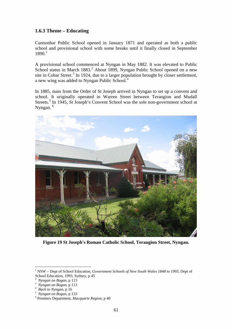
61
1.6.3 Theme – Educating Cannonbar Public School opened in January 1871 and operated as both a public school and provisional school with some breaks until it finally closed in September 1890.1 A provisional school commenced at Nyngan in May 1882. It was elevated to Public School status in March 1883.2 About 1899, Nyngan Public School opened on a new site in Cobar Street.3 In 1924, due to a larger population brought by closer settlement, a new wing was added to Nyngan Public School.4 In 1885, nuns from the Order of St Joseph arrived in Nyngan to set up a convent and school. It originally operated in Warren Street between Terangion and Mudall Streets.5 In 1945, St Joseph’s Convent School was the sole non-government school at Nyngan. 6
Figure 19 St Joseph's Roman Catholic School, Terangion Street, Nyngan.
1 NSW – Dept of School Education, Government Schools of New South Wales 1848 to 1993, Dept of School Education, 1993, Sydney, p 45 2 Nyngan on Bogan, p 113 3 Nyngan on Bogan, p 113 4 Back to Nyngan, p 16 5 Nyngan on Bogan, p 133 6 Premiers Department, Macquarie Region, p 40
62
A few private schools also operated. In 1904, a Miss Millar conducted a Private ladies’ school in Wambiana Street, Nyngan. 1 Schools also appeared in smaller centres. After residents of Girilambone petitioned for a school, the school commenced on 18 January 1882.2 It was later known as the Girilambone Mine Public School after a new school opened in the government town at the railway in July 1897. The mine school closed in October 1904.3 Coolabah Provisional School opened in January 1887 becoming a Public School in October 1892.4 A new school building opened in October 1912 followed by a new school residence in May 1913.5 A Provisional School opened at Hermidale in May 1901 being elevated to a Public School in October 1901.6 At Bobahah, a Public School opened in August 1897 and operated until it was downgraded to a Provisional School in September 1919 before closing in May 1923.7 A Provisional School opened at Miandetta in September 1912 and operated until May 1945.8 Education expanded in the post war period. St Joseph’s Infants School in Bogan Street opened in 1967. 9 Nyngan High School opened in 1974.10 A new Nyngan Public School on a new site in Cathundral Street was officially opened on 27 October 1978.11
1.6.4 Theme - Observing religious practices An Anglican Church to be called St Paul’s was licensed at Nyngan on 1 November 1883. 12 In 1889, a separate Nyngan Anglican parish was formed. 13 On 29 May 1897, the Anglican Church of St Paul, Nyngan, built of cypress pine was consecrated.14 In 1920, the foundation stone of St Mark’s Church of England was laid at Bogan and Terangion Streets, Nyngan. 15 It was dedicated on 1 December 1926.16 A small Roman Catholic Church was commenced at the corner of Bogan and Terangion Streets in 1889 when Rev Walter Curran arrived in Nyngan.17 A Roman 1 Nyngan on Bogan, p 145 2 Education, School File, Girilambone, 1881-1903, SRNSW 5/15993.2 3 NSW – Dept of School Education, Government Schools of New South Wales 1848 to 1993, Dept of School Education, 1993, Sydney, p 72 4 NSW – Dept of School Education, Government Schools of New South Wales 1848 to 1993, Dept of School Education, 1993, Sydney, p 53 5 P Thompson, Under the shade of the Coolibah, p 22 6 NSW – Dept of School Education, Government Schools of New South Wales 1848 to 1993, Dept of School Education, 1993, Sydney, p 80 7 NSW – Dept of School Education, Government Schools of New South Wales 1848 to 1993, Dept of School Education, 1993, Sydney, p 34 8 NSW – Dept of School Education, Government Schools of New South Wales 1848 to 1993, Dept of School Education, 1993, Sydney, p 101 9 Nyngan on Bogan, p 113 10 Nyngan on Bogan, p 114 11 Nyngan on Bogan, p 114 12 Nyngan on Bogan, p 128 13 Campbell, Nyngan, np 14 Campbell, Nyngan, np 15 Nyngan on Bogan, p 128 16 Campbell, Nyngan, np 17 Nyngan on Bogan, p 133
63
Catholic Church was built at the corner of Bogan and Terangion Streets, Nyngan in 1900.1 A brick Roman Catholic presbytery was built in Bogan Street, Nyngan in 1924.2 In 1885, nuns from the Order of St Joseph had arrived in Nyngan to set up a convent and school that originally operated in Warren Street between Terangion and Mudall Streets.3 A new St Joseph’s Roman Catholic Convent opened in Nyngan in 1914.4 After the Methodists had been holding services in the Oddfellows Hall in Cobar Street, a Methodist Church was built in Cobar Street in 1894.5 In 1939, Nyngan became the administrative centre for the Methodist Church's Far West Mission. 6 Churches were also built in smaller centres. The Anglican Church of St Mary the Virgin (‘Marra Church’) 61 miles from Nyngan was built in 1913.7 On 2 December 1923, the first service was held in St Faith’s Anglican Church at Hermidale.8 The first service at St Paul’s Anglican Church, Girilambone, followed on 30 August 1925.9 A community built Church of England known as St Matthew’s opened at Monkey Road, West Bogan in 1939.10
1.6.5 Theme - Supplying retail, financial and professional services The first commercial services emerged in the village of Canonba/Canonbar where a store, the Cannonbar hotel and a post office emerged on Brown’s land. The private town of Girilambone set up next to the mine attracted some storekeepers such as George Buist and W N Willis. Nyngan quickly emerged attracting business people such as Willis and Buist away from Girilambone. When surveyor Arthur Burgess laid out the town of Nyngan in February 1882, there was already a hotel and a store on the town site.11 As the town grew so did its commercial facilities. By the 1890s, a number of medical practitioners were practising at Nyngan. They included Doctors Germyn, Westrum, Hickey and Gilray.12 Solicitors in Nyngan in 1890 included James L Byrne and D Burns.13 About 1900, A J L Flashman commenced a long standing legal practice in Nyngan.14 One of the most notable businesses was that of Bleakley and Barringer. On 20 November 1888, Albert Caro leased his general store near the Bogan River to Arthur
1 Nyngan on Bogan, p 133 2 Nyngan on Bogan, p 133 3 Nyngan on Bogan, p 133 4 Nyngan on Bogan, p 131 5 Nyngan on Bogan, p 134 6 Nyngan on Bogan, p 134 7 Nyngan on Bogan, p 130 8 Campbell, Nyngan, np 9 Nyngan on Bogan, p 128 10 Nyngan on Bogan, p 130-2 11 Campbell, Nyngan, np 12 Nyngan on Bogan, p 118 13 Nyngan on Bogan, p 247 14 Nyngan on Bogan, p 245
64
T Bleakley. Bleakley and Barringer bought the property on 1 June 1891.1 In 1894, A T Bleakley and Frank Page Barringer built a new general store at the corner of Pangee and Tabratong Streets on the site of the old Metropolitan Hotel. When Bleakley drowned that year, Barringer continued on his own. It became the major store in Nyngan.2 Barringer’s department store on the corner of Panjee and Tabratong Streets burned down in March 1960 to be replaced by the Overlander Hotel built by Tooth’s. 3 Hotels were a significant part of the commercial and social life of the community. The earliest hotels were at Canonba and along the roads that traversed the district. Once Nyngan was established, it attracted many hotels. The following Tables show the hotels licensed in the Bogan district. Hotels of the Bogan District 1865 Sign Address Licensee Cannonbar Hotel Cannonbar John Brown Source: NSWGG, 8 Sept 1865, p 2038 Hotels of the Bogan District 1873 Sign Address Licensee Cannonbar Hotel Cannonbar John Cuff Royal Cannonbar Henry Isaac Elmswood [Bogan??] Monkey, Bogan River Robert Lamph Half-way House Duck Creek, Bourke Road Layars Larson Commercial Canonbar John Quin Source: NSWGG, 9 Sept 1873, p 2462 Hotels of the Bogan District 1880 Sign Address Licensee Three-legs-of-man Hotel Road – Cannonbar to Tindary John Daley Post Office Hotel Cannonbar George Buist Traveller’s Rest [Bogan??] Duck Creek Road, Warren to
Cannonbar Henry Ellis
Commercial Cannonbar John Quinn Bayswater Hotel Buddabadah, Bogan River John Smith Skinner Royal Oak Hotel Willeroon George Wright Royal Cannonbar Henry Isaacs Elmswood Hotel Monkey, Bogan River Rebecca Lamph Half-way House Duck Creek, Bourke Road Layars Larson Source: NSWGG, 17 Sept 1880, p 4831-2, 4834 1 Lot 2 Section 2, C T 687 f 229 2 Back to Nyngan, p 23 3 Nyngan on Bogan, p 142
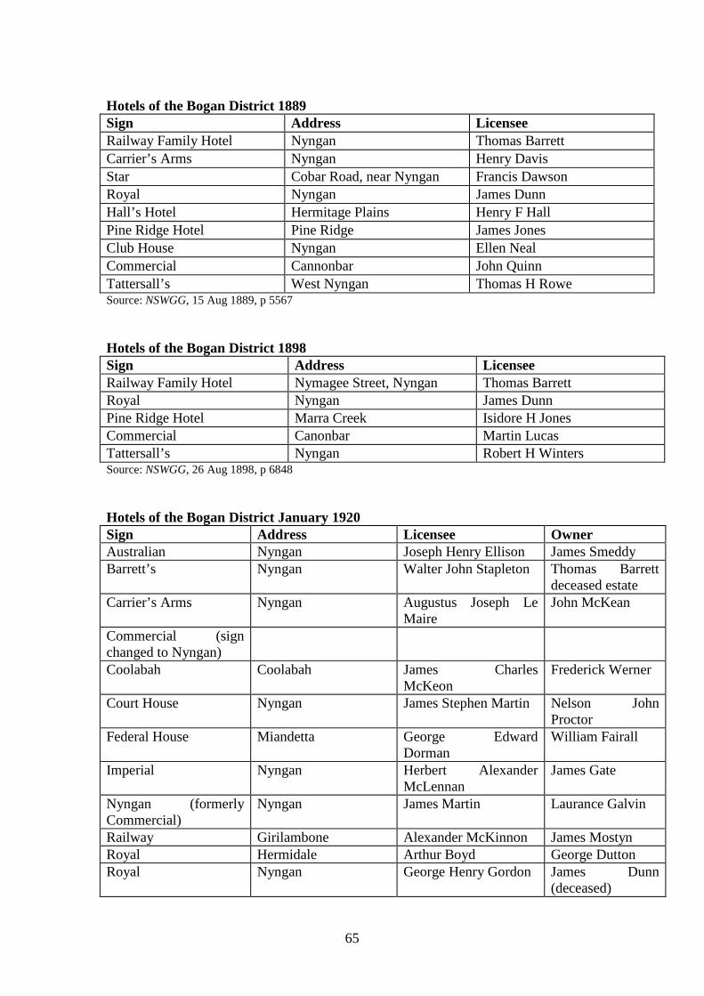
65
Hotels of the Bogan District 1889 Sign Address Licensee Railway Family Hotel Nyngan Thomas Barrett Carrier’s Arms Nyngan Henry Davis Star Cobar Road, near Nyngan Francis Dawson Royal Nyngan James Dunn Hall’s Hotel Hermitage Plains Henry F Hall Pine Ridge Hotel Pine Ridge James Jones Club House Nyngan Ellen Neal Commercial Cannonbar John Quinn Tattersall’s West Nyngan Thomas H Rowe Source: NSWGG, 15 Aug 1889, p 5567 Hotels of the Bogan District 1898 Sign Address Licensee Railway Family Hotel Nymagee Street, Nyngan Thomas Barrett Royal Nyngan James Dunn Pine Ridge Hotel Marra Creek Isidore H Jones Commercial Canonbar Martin Lucas Tattersall’s Nyngan Robert H Winters Source: NSWGG, 26 Aug 1898, p 6848 Hotels of the Bogan District January 1920 Sign Address Licensee Owner Australian Nyngan Joseph Henry Ellison James Smeddy Barrett’s Nyngan Walter John Stapleton Thomas Barrett
deceased estate Carrier’s Arms Nyngan Augustus Joseph Le
Maire John McKean
Commercial (sign changed to Nyngan)
Coolabah Coolabah James Charles McKeon
Frederick Werner
Court House Nyngan James Stephen Martin Nelson John Proctor
Federal House Miandetta George Edward Dorman
William Fairall
Imperial Nyngan Herbert Alexander McLennan
James Gate
Nyngan (formerly Commercial)
Nyngan James Martin Laurance Galvin
Railway Girilambone Alexander McKinnon James Mostyn Royal Hermidale Arthur Boyd George Dutton Royal Nyngan George Henry Gordon James Dunn
(deceased)
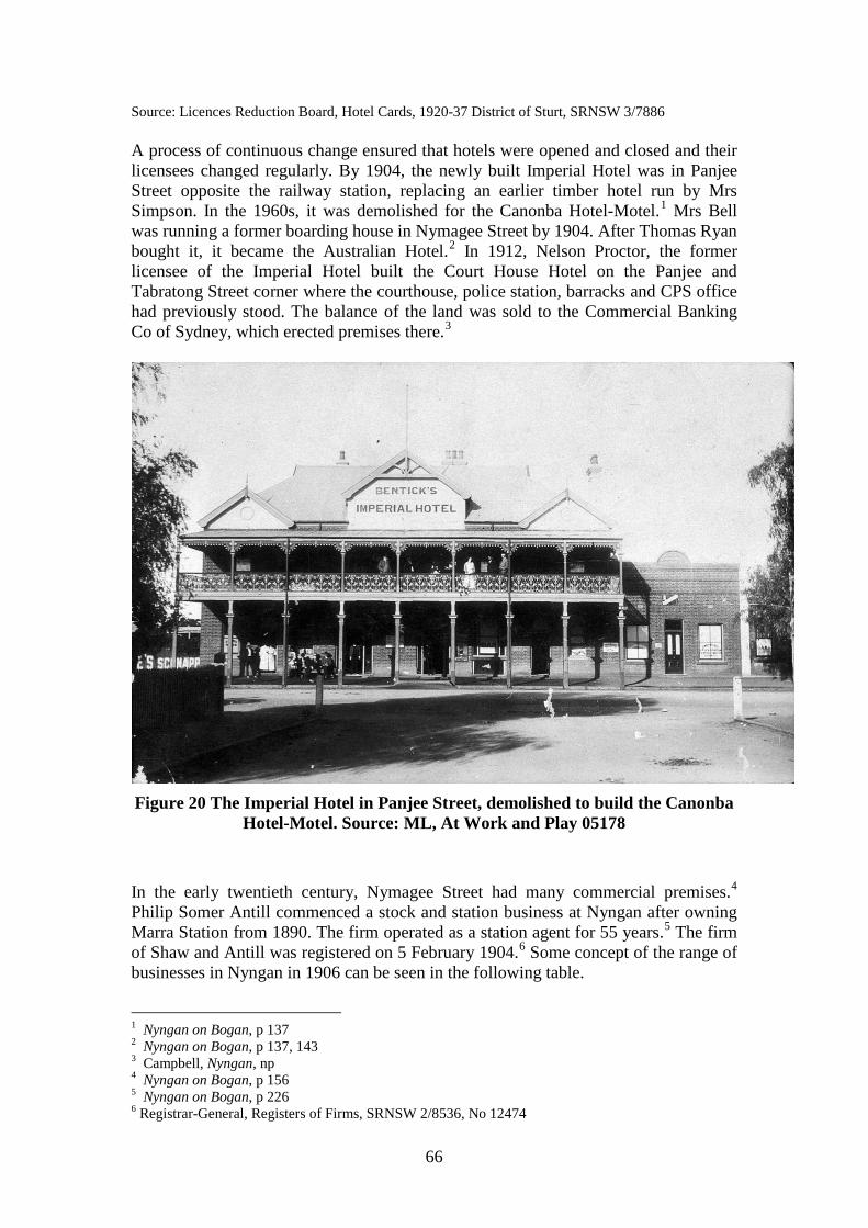
66
Source: Licences Reduction Board, Hotel Cards, 1920-37 District of Sturt, SRNSW 3/7886 A process of continuous change ensured that hotels were opened and closed and their licensees changed regularly. By 1904, the newly built Imperial Hotel was in Panjee Street opposite the railway station, replacing an earlier timber hotel run by Mrs Simpson. In the 1960s, it was demolished for the Canonba Hotel-Motel.1 Mrs Bell was running a former boarding house in Nymagee Street by 1904. After Thomas Ryan bought it, it became the Australian Hotel.2 In 1912, Nelson Proctor, the former licensee of the Imperial Hotel built the Court House Hotel on the Panjee and Tabratong Street corner where the courthouse, police station, barracks and CPS office had previously stood. The balance of the land was sold to the Commercial Banking Co of Sydney, which erected premises there.3
Figure 20 The Imperial Hotel in Panjee Street, demolished to build the Canonba
Hotel-Motel. Source: ML, At Work and Play 05178 In the early twentieth century, Nymagee Street had many commercial premises.4 Philip Somer Antill commenced a stock and station business at Nyngan after owning Marra Station from 1890. The firm operated as a station agent for 55 years.5 The firm of Shaw and Antill was registered on 5 February 1904.6 Some concept of the range of businesses in Nyngan in 1906 can be seen in the following table.
1 Nyngan on Bogan, p 137 2 Nyngan on Bogan, p 137, 143 3 Campbell, Nyngan, np 4 Nyngan on Bogan, p 156 5 Nyngan on Bogan, p 226 6 Registrar-General, Registers of Firms, SRNSW 2/8536, No 12474
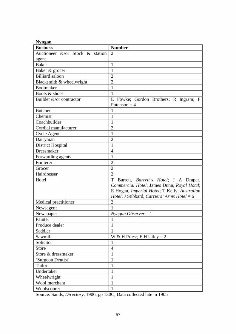
67
Nyngan Business Number Auctioneer &/or Stock & station agent
2
Baker 1 Baker & grocer 1 Billiard saloon 2 Blacksmith & wheelwright 2 Bootmaker 1 Boots & shoes 1 Builder &/or contractor E Fowke; Gordon Brothers; R Ingram; F
Putenson = 4 Butcher 1 Chemist 1 Coachbuilder 1 Cordial manufacturer 2 Cycle Agent 1 Dairyman 2 District Hospital 1 Dressmaker 4 Forwarding agents 1 Fruiterer 2 Grocer 2 Hairdresser 2 Hotel T Barrett, Barrett’s Hotel; J A Draper,
Commercial Hotel; James Dunn, Royal Hotel; E Hogan, Imperial Hotel; T Kelly, Australian Hotel; J Stibbard, Carriers’ Arms Hotel = 6
Medical practitioner 2 Newsagent 1 Newspaper Nyngan Observer = 1 Painter 1 Produce dealer 1 Saddler 1 Sawmill W & H Priest; E H Utley = 2 Solicitor 1 Store 4 Store & dressmaker 1 ‘Surgeon Dentist’ 1 Tailor 1 Undertaker 1 Wheelwright 1 Wool merchant 1 Woolscourer 1 Source: Sands, Directory, 1906, pp 130C; Data collected late in 1905
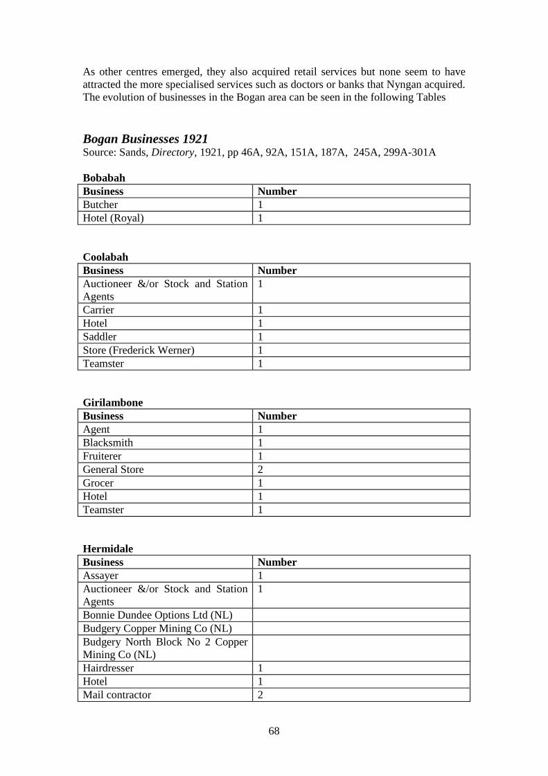
68
As other centres emerged, they also acquired retail services but none seem to have attracted the more specialised services such as doctors or banks that Nyngan acquired. The evolution of businesses in the Bogan area can be seen in the following Tables Bogan Businesses 1921 Source: Sands, Directory, 1921, pp 46A, 92A, 151A, 187A, 245A, 299A-301A Bobabah Business Number Butcher 1 Hotel (Royal) 1 Coolabah Business Number Auctioneer &/or Stock and Station Agents
1
Carrier 1 Hotel 1 Saddler 1 Store (Frederick Werner) 1 Teamster 1 Girilambone Business Number Agent 1 Blacksmith 1 Fruiterer 1 General Store 2 Grocer 1 Hotel 1 Teamster 1 Hermidale Business Number Assayer 1 Auctioneer &/or Stock and Station Agents
1
Bonnie Dundee Options Ltd (NL) Budgery Copper Mining Co (NL) Budgery North Block No 2 Copper Mining Co (NL)
Hairdresser 1 Hotel 1 Mail contractor 2
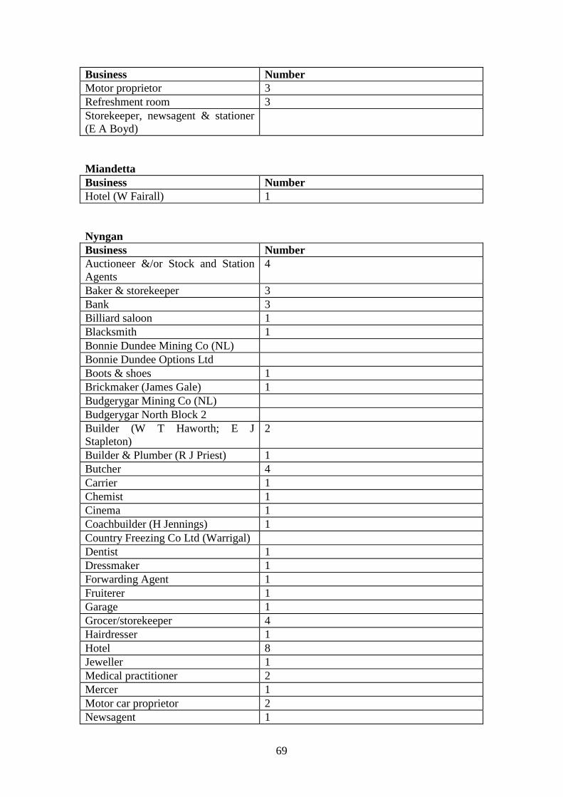
69
Business Number Motor proprietor 3 Refreshment room 3 Storekeeper, newsagent & stationer (E A Boyd)
Miandetta Business Number Hotel (W Fairall) 1 Nyngan Business Number Auctioneer &/or Stock and Station Agents
4
Baker & storekeeper 3 Bank 3 Billiard saloon 1 Blacksmith 1 Bonnie Dundee Mining Co (NL) Bonnie Dundee Options Ltd Boots & shoes 1 Brickmaker (James Gale) 1 Budgerygar Mining Co (NL) Budgerygar North Block 2 Builder (W T Haworth; E J Stapleton)
2
Builder & Plumber (R J Priest) 1 Butcher 4 Carrier 1 Chemist 1 Cinema 1 Coachbuilder (H Jennings) 1 Country Freezing Co Ltd (Warrigal) Dentist 1 Dressmaker 1 Forwarding Agent 1 Fruiterer 1 Garage 1 Grocer/storekeeper 4 Hairdresser 1 Hotel 8 Jeweller 1 Medical practitioner 2 Mercer 1 Motor car proprietor 2 Newsagent 1
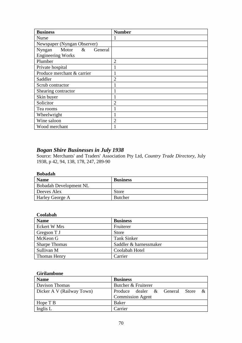
70
Business Number Nurse 1 Newspaper (Nyngan Observer) Nyngan Motor & General Engineering Works
Plumber 2 Private hospital 1 Produce merchant & carrier 1 Saddler 2 Scrub contractor 1 Shearing contractor 1 Skin buyer 1 Solicitor 2 Tea rooms 1 Wheelwright 1 Wine saloon 2 Wood merchant 1 Bogan Shire Businesses in July 1938 Source: Merchants' and Traders' Association Pty Ltd, Country Trade Directory, July 1938, p 42, 94, 138, 178, 247, 289-90 Bobadah Name Business Bobadah Development NL Deeves Alex Store Harley George A Butcher Coolabah Name Business Eckert W Mrs Fruiterer Gregson T J Store McKeon G Tank Sinker Sharpe Thomas Saddler & harnessmaker Sullivan M Coolabah Hotel Thomas Henry Carrier Girilambone Name Business Davison Thomas Butcher & Fruiterer Dicker A V (Railway Town) Produce dealer & General Store &
Commission Agent Hope T B Baker Inglis L Carrier
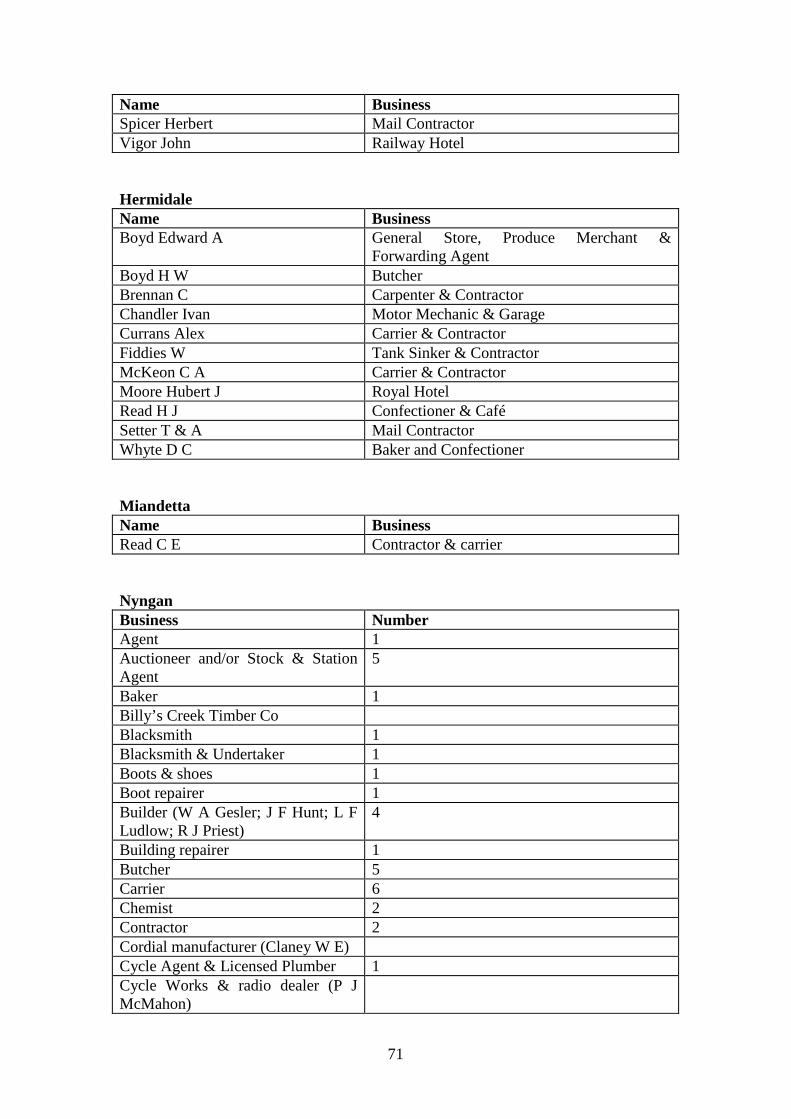
71
Name Business Spicer Herbert Mail Contractor Vigor John Railway Hotel Hermidale Name Business Boyd Edward A General Store, Produce Merchant &
Forwarding Agent Boyd H W Butcher Brennan C Carpenter & Contractor Chandler Ivan Motor Mechanic & Garage Currans Alex Carrier & Contractor Fiddies W Tank Sinker & Contractor McKeon C A Carrier & Contractor Moore Hubert J Royal Hotel Read H J Confectioner & Café Setter T & A Mail Contractor Whyte D C Baker and Confectioner Miandetta Name Business Read C E Contractor & carrier Nyngan Business Number Agent 1 Auctioneer and/or Stock & Station Agent
5
Baker 1 Billy’s Creek Timber Co Blacksmith 1 Blacksmith & Undertaker 1 Boots & shoes 1 Boot repairer 1 Builder (W A Gesler; J F Hunt; L F Ludlow; R J Priest)
4
Building repairer 1 Butcher 5 Carrier 6 Chemist 2 Contractor 2 Cordial manufacturer (Claney W E) Cycle Agent & Licensed Plumber 1 Cycle Works & radio dealer (P J McMahon)
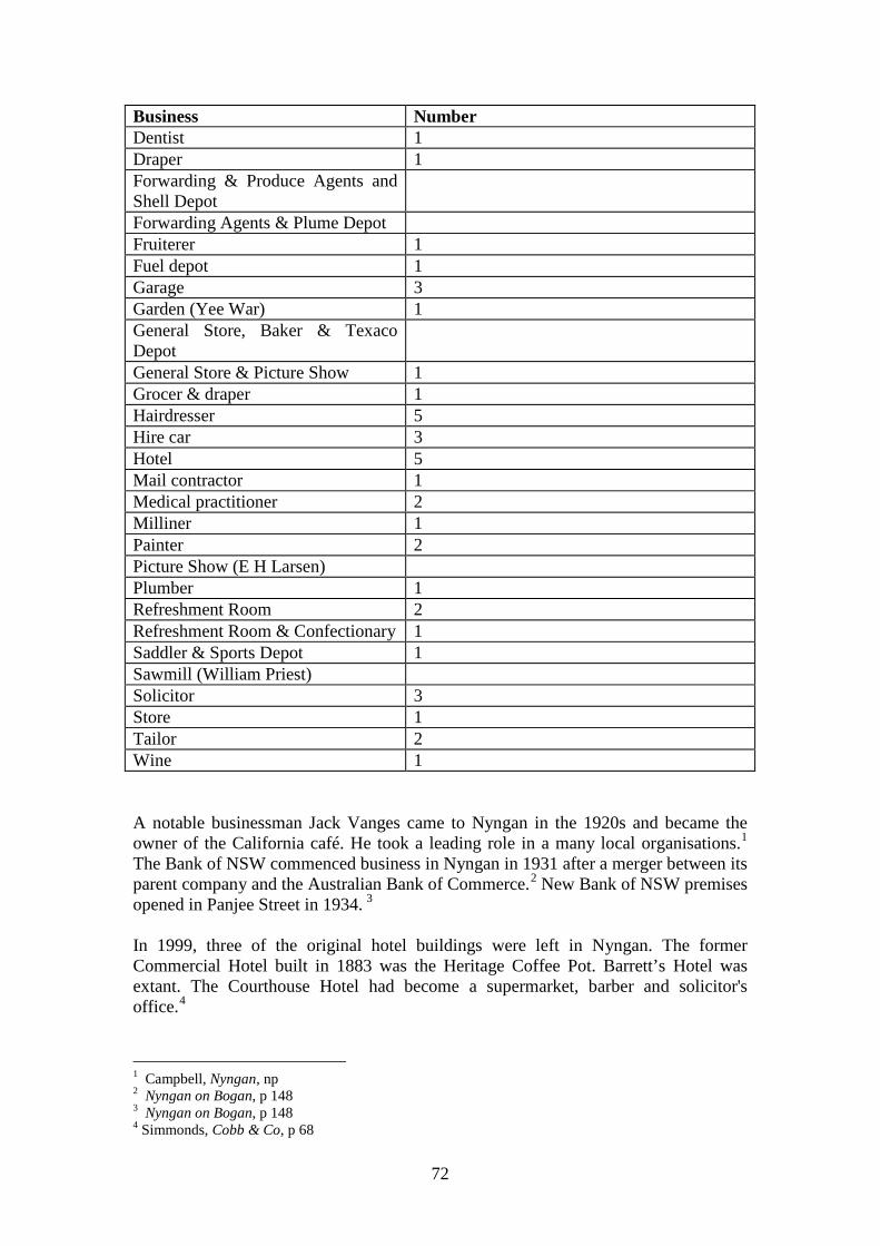
72
Business Number Dentist 1 Draper 1 Forwarding & Produce Agents and Shell Depot
Forwarding Agents & Plume Depot Fruiterer 1 Fuel depot 1 Garage 3 Garden (Yee War) 1 General Store, Baker & Texaco Depot
General Store & Picture Show 1 Grocer & draper 1 Hairdresser 5 Hire car 3 Hotel 5 Mail contractor 1 Medical practitioner 2 Milliner 1 Painter 2 Picture Show (E H Larsen) Plumber 1 Refreshment Room 2 Refreshment Room & Confectionary 1 Saddler & Sports Depot 1 Sawmill (William Priest) Solicitor 3 Store 1 Tailor 2 Wine 1 A notable businessman Jack Vanges came to Nyngan in the 1920s and became the owner of the California café. He took a leading role in a many local organisations.1 The Bank of NSW commenced business in Nyngan in 1931 after a merger between its parent company and the Australian Bank of Commerce.2 New Bank of NSW premises opened in Panjee Street in 1934. 3 In 1999, three of the original hotel buildings were left in Nyngan. The former Commercial Hotel built in 1883 was the Heritage Coffee Pot. Barrett’s Hotel was extant. The Courthouse Hotel had become a supermarket, barber and solicitor's office.4
1 Campbell, Nyngan, np 2 Nyngan on Bogan, p 148 3 Nyngan on Bogan, p 148 4 Simmonds, Cobb & Co, p 68
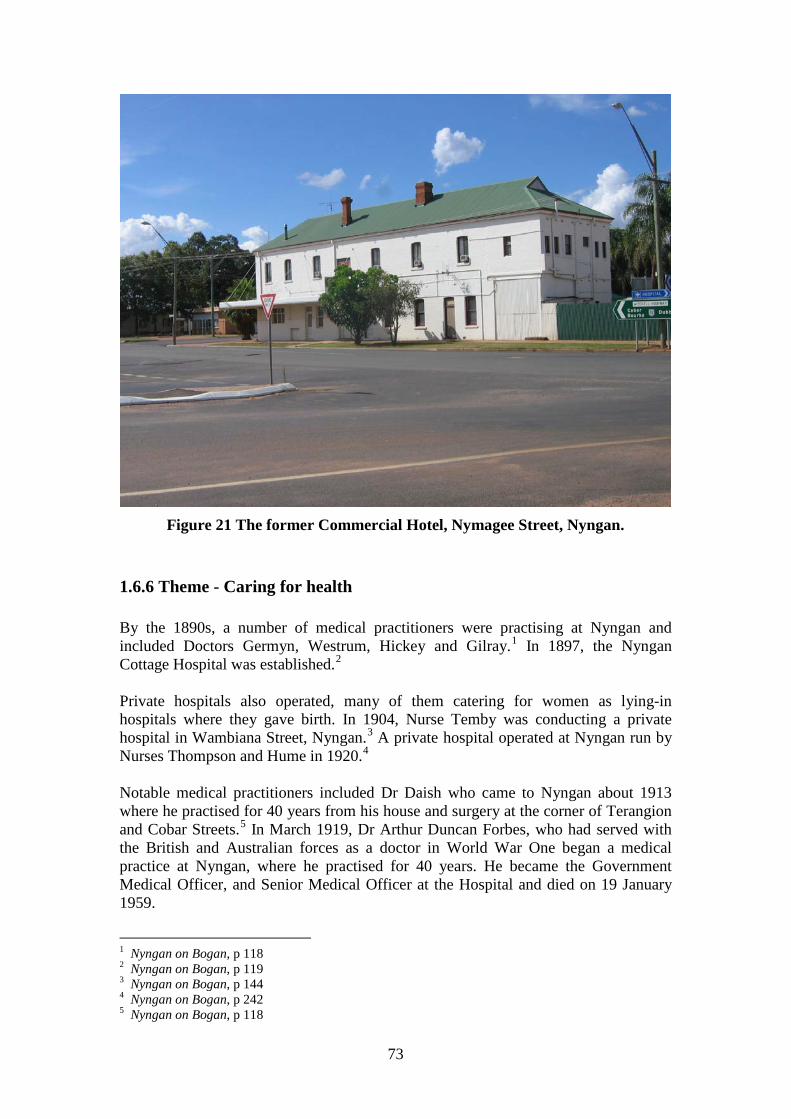
73
Figure 21 The former Commercial Hotel, Nymagee Street, Nyngan.
1.6.6 Theme - Caring for health By the 1890s, a number of medical practitioners were practising at Nyngan and included Doctors Germyn, Westrum, Hickey and Gilray.1 In 1897, the Nyngan Cottage Hospital was established.2 Private hospitals also operated, many of them catering for women as lying-in hospitals where they gave birth. In 1904, Nurse Temby was conducting a private hospital in Wambiana Street, Nyngan.3 A private hospital operated at Nyngan run by Nurses Thompson and Hume in 1920.4 Notable medical practitioners included Dr Daish who came to Nyngan about 1913 where he practised for 40 years from his house and surgery at the corner of Terangion and Cobar Streets.5 In March 1919, Dr Arthur Duncan Forbes, who had served with the British and Australian forces as a doctor in World War One began a medical practice at Nyngan, where he practised for 40 years. He became the Government Medical Officer, and Senior Medical Officer at the Hospital and died on 19 January 1959.
1 Nyngan on Bogan, p 118 2 Nyngan on Bogan, p 119 3 Nyngan on Bogan, p 144 4 Nyngan on Bogan, p 242 5 Nyngan on Bogan, p 118
74
An ambulance service commenced at Nyngan about 1924 with a car loaned from Sydney and driven by CWA volunteers. 1 In 1942, the Nyngan District Ambulance was inaugurated. 2 A new ambulance station was built at Nyngan on 20 September 1969.3 Nyngan Hospital grew, as district needs increased. In 1943, new private and intermediate sections were added.4 By 1948, it had 30 beds.5 The NSW Premier, Jack Renshaw opened additions to the Hospital in 1952.6 The Hospital was closed in April 2009 and offered for sale in July 2009.7 A new Hospital opened nearby.
1.6.7 Theme - Enjoying leisure Originally situated in an isolated area, early settlers of Bogan Shire made their own entertainment. Once more intensive settlemnt emerged, there were more options usually commencing with hotel based entertainment, including gambling and sporting events arranged by the publican. Nyngan was the site where early clubs and other leisure activities commenced. By 1888, a Nyngan Gun Club was extant. 8 The first town band was formed in 1892.9 By 1898, the Nyngan Picnic Race Club was in existence. 10 The Masonic Lodge Oxley No 225 was formed at Nyngan in 1898. 11 Sport was a major leisure activity for those wanting something active, whilst more relaxed pursuits such as picnicking also occupied leisure hours. About 1900, the Beablebar Picnic Race Club commenced and was named after the property of George Forbes where the races were held. 12 The Nyngan Lawn Tennis Club was formed in 1901.13 By 1903, a cycle club was extant at Nyngan.14 The Nyngan Rifle Club formed in 1908 used butts two miles north of town.15 The original golf club was formed in 1913 but lapsed. 16 Clubs built their own premises and cultural facilities were erected to cater for the own. In 1910, the Nyngan Masonic Temple was built.17 In 1916, the Railway Commissioners took over the existing Nyngan School of Arts and ran it as a Railway 1 Nyngan on Bogan, p 122 2 Nyngan on Bogan, p 122 3 Nyngan on Bogan, p 122 4 Nyngan on Bogan, p 119 5 Premiers Department, Macquarie Region, p 20 6 Nyngan on Bogan, p 119 7 http://www.abc.net.au/news/stories/2009/07/15/2626636.htm. Accessed 20 January 2011 8 Campbell, Nyngan, np 9 Back to Nyngan, p 27 10 Nyngan on Bogan, p 183 11 Back to Nyngan, p 30 12 Nyngan on Bogan, p 184 13 Campbell, Nyngan, np 14 Nyngan on Bogan, p 194 15 Back to Nyngan, p 32 16 Nyngan on Bogan, p 184 17 Nyngan on Bogan, p 175
75
and Tramway Institute.1 On 9 December 1916, the Austral Kinema at Nyngan Town Hall commenced with screening of films of World War One.2 One of the more unusual entertainments of that era was the Warrigal Boska Band, a local band from the meatworks who played drums and mouth organs in the 1910s.3 In the 1920s, after the disruption of the war years and with the increase of population due to closer settlement, new clubs and sports commenced. In the early 1920s, rugby league was played at Nyngan under coach Dr A D Forbes.4 The Nyngan Golf Club revived in April 1927 using land at ‘Bogan Villa’ on the Tottenham Road.5 Nyngan Gun Club was formed on 23 June 1928.6 Thereafter, the pace slowed. A bowling club commenced at Nyngan in 1943.7 In 1947, the Nyngan Golf Club was able to lease land on Tottenham Road from the Dept of Lands for a larger golf course.8 The foundation stone of the War Memorial Swimming Pool was laid by the Governor of NSW on 20 April 1948.9 It officially opened in November 1952.10 The Nyngan RSL and Civic Club was formed in 1955.11 A new purpose-built RSL Club opened in Pangee Street on 2 April 1960.12 A Scout Group formed at Nyngan in 1959 followed by a Girl Guide unit formed on 4 May 1960. 13 By 2008, tourist attractions at Nyngan included the Helicopter, the Historical Society Museum, Old Canonba Pioneer Memorial, Coolabah Well, Cobb & Co Coach and the Mid State Shearing Shed.14
1 Back to Nyngan, p 27 2 Nyngan on Bogan, p 146 3 Nyngan on Bogan, p 49 4 Nyngan on Bogan, p 187 5 Back to Nyngan, p 29 6 Back to Nyngan, p 23 7 Nyngan on Bogan, p 193 8 Nyngan on Bogan, p 185 9 Nyngan on Bogan, p 106 10 Nyngan on Bogan, p 195 11 Nyngan on Bogan, p 168 12 Nyngan on Bogan, p 168 13 Nyngan on Bogan, p 173 14 Bogan Shire Council, Community Plan, 2008-9, p 20
76
1.7 Contextual Essay - Developing a community
1.7.1 Theme – Governing Nyngan Municipal Council was gazetted on 17 February 1891 and was soon looking after the town. The new Municipality had a population of 1,355 and 315 dwellings, of which 200 were of wooden slab construction and 23 were of brick. 1 The purpose-built Nyngan Town Hall and Council Chambers was completed in 1897.2 Previously the state government had looked after services usually through the agency of local magistrates who acted as mediators between the local community and the State Government. The Municipal Council only covered the town of Nyngan. On 3 December 1906, as part of a wholesale gazettal of local government authorities by the NSW state government, Bogan Shire was formed to look after the rural area, which included the villages of Girilambone, Bobadah and Coolabah.3 The foundation stone of new Bogan Shire offices was laid on 7 December 1935. 4 In 1958, Bogan Shire had recently acquired an additional area from ‘the Coolabah end of the Western Division of 552,220 acres as well as 105,980 acres from the Warren area to make a total area of 3,607,320 acres.5 The State Government remained responsible for a variety of matters. In 1948 State Government officers at Nyngan were the Clerk of Petty Sessions, Crown Land Agent, Forester, Warden’s Clerk of the Mines Dept, and the Stock Inspector.6 Nyngan Municipality and Bogan Shire were amalgamated on 1 January 1972. 7
1.7.2 Theme – Maintaining law and order Mounted troopers under the Crown Lands Commissioner for the Wellington Pastoral District originally maintained law and order. As settlement proceeded, more permanent forms of law and order were established. ‘Cannonbar’ was gazetted as a place for holding petty sessions on 4 March 1864.8 Canonba Police Station was set up in 1864 as part of the Western Police District with two mounted constables.9
1 Campbell, Nyngan, np 2 Nyngan on Bogan, p 97 3 Nyngan on Bogan, p 97 4 Campbell, Nyngan, np 5 Campbell, Nyngan, np 6 Premiers Department, Macquarie Region, p 36 7 Nyngan on Bogan, p 100 8 H Golder, High and Responsible Office: A History of the NSW Magistracy, Sydney University Press, Sydney, 1991, p 233 9 Nyngan on Bogan, p 111
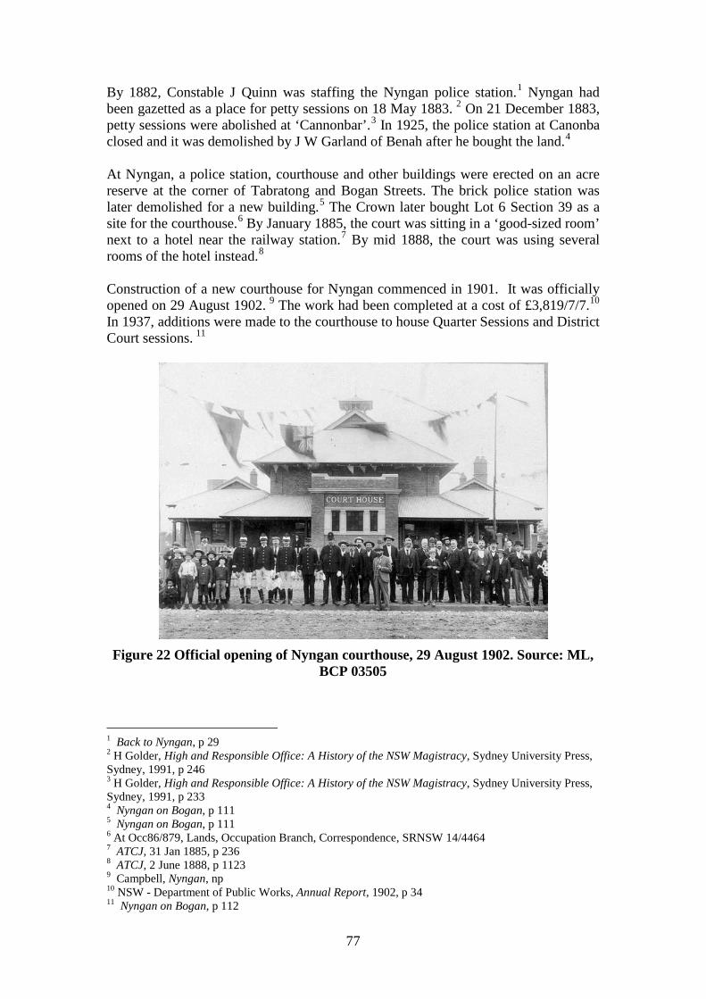
77
By 1882, Constable J Quinn was staffing the Nyngan police station.1 Nyngan had been gazetted as a place for petty sessions on 18 May 1883. 2 On 21 December 1883, petty sessions were abolished at ‘Cannonbar’.3 In 1925, the police station at Canonba closed and it was demolished by J W Garland of Benah after he bought the land.4 At Nyngan, a police station, courthouse and other buildings were erected on an acre reserve at the corner of Tabratong and Bogan Streets. The brick police station was later demolished for a new building.5 The Crown later bought Lot 6 Section 39 as a site for the courthouse.6 By January 1885, the court was sitting in a ‘good-sized room’ next to a hotel near the railway station.7 By mid 1888, the court was using several rooms of the hotel instead.8 Construction of a new courthouse for Nyngan commenced in 1901. It was officially opened on 29 August 1902. 9 The work had been completed at a cost of £3,819/7/7.10 In 1937, additions were made to the courthouse to house Quarter Sessions and District Court sessions. 11
Figure 22 Official opening of Nyngan courthouse, 29 August 1902. Source: ML,
BCP 03505
1 Back to Nyngan, p 29 2 H Golder, High and Responsible Office: A History of the NSW Magistracy, Sydney University Press, Sydney, 1991, p 246 3 H Golder, High and Responsible Office: A History of the NSW Magistracy, Sydney University Press, Sydney, 1991, p 233 4 Nyngan on Bogan, p 111 5 Nyngan on Bogan, p 111 6 At Occ86/879, Lands, Occupation Branch, Correspondence, SRNSW 14/4464 7 ATCJ, 31 Jan 1885, p 236 8 ATCJ, 2 June 1888, p 1123 9 Campbell, Nyngan, np 10 NSW - Department of Public Works, Annual Report, 1902, p 34 11 Nyngan on Bogan, p 112
78
The villages also acquired police stations and court sessions. Girilambone was gazetted as a place for petty sessions on 21 November 1882 but this role was abolished on 7 September 1886.1 Girilambone was again gazetted as a place for holding petty sessions on 10 November 1899.2 Since 1896, a mounted policeman had been stationed at Girilambone. In 1899, a police station and lock-up was erected at Girilambone at a cost of £848. The police station closed in 1975.3 From 30 September 1970 onwards, Girilambone was no longer a site for petty sessions.4 A police station had been established at Coolabah by 1891 when additions worth £309/12/6 were completed to the building. 5 Coolabah was gazetted as place for petty sessions on 13 December 1898 but it was abolished on 20 July 1905. 6 At Nyngan, a new police station was erected on the site of the old one in 1976. 7
1.7.3 Theme - Defending the nation Like many country areas, Bogan Shire provided a number of enlistments for the services in the Great War of 1914-18 later known as World War One. There was a total of 64 enlistments from Nyngan and 1 from Girilambone though many more gave their place of birth as Nyngan (193). The following table summarises that data. World War One Enlistments Bogan Shire Locality Enlistments Birthplace Coolabah 13 Girilambone 1 15 Nyngan 64 193 Source: http://mappingouranzacs.naa.gov.au. Accessed 1 November 2010 One of the notable enlistments was Arthur Charles Hall, of Glenelg, Coolabah who showed such courage at Peronne on 1 and 2 September 1918 that he was awarded the Victoria Cross.8 The war had other impacts on the town. In March 1919, Dr Arthur Duncan Forbes, who had served with British and Australian forces as a doctor, began his medical practice at Nyngan. War Memorials provided a community reminder of that traumatic event. On 10 August 1920, the foundation stone of the Nyngan Soldiers’ Memorial was laid. 9
1 H Golder, High and Responsible Office: A History of the NSW Magistracy, Sydney University Press, Sydney, 1991, p 238 2 H Golder, High and Responsible Office: A History of the NSW Magistracy, Sydney University Press, Sydney, 1991, p 238 3 K H Heckendorf, Girilambone 100 Years, Dubbo Secretarial Services, Dubbo, Oct 1980, p 51 4 H Golder, High and Responsible Office: A History of the NSW Magistracy, Sydney University Press, Sydney, 1991, p 238 5 NSW - Department of Public Works, Annual Report, 1891, p 100 6 H Golder, High and Responsible Office: A History of the NSW Magistracy, Sydney University Press, Sydney, 1991, p 235 7 Nyngan on Bogan, p 112 8 Nyngan on Bogan, p 224-5 9 Nyngan on Bogan, p 201
79
Other War Memorials were also set up such as that at Hermidale that lists 14 enlistments in World War One of whom three were killed. A further 25 enlistments in World War Two are also shown including two women who joined the WAAF. World War Two also attracted significant numbers of enlistments from Bogan Shire as shown in the following Table. World War Two Enlistments Bogan Shire Locality Place of Enlistment
(All services) Address at Enlistment
Birthplace
Coolabah - 18 23 Girilambone - 46 11 Hermidale 15 13 Nyngan 99 216 521 Source: http://www.ww2roll.gov.au/script/place.asp. Accessed 1 November 2010 Unlike many country areas, there appear to have been no major defence facilities built in Bogan Shire. Nyngan aerodrome is reported to have been used as a satellite training field for the air force.1 In fact, it was an emergency landing ground. On 19 August 1943, Nyngan Airfield was reported to be surfaced with red loam that became soft after rain. It was useful for medium and light transport aircraft but only in dry weather.2
1.7.4 Theme – Developing community services Community organisations reflect the freedom of citizens to associate in ways that serve their needs and permit them to cater for wants that formal government or its agencies often do not seek to serve. Thus, they mirror both the strengths and limitations of the community that create them. The Loyal Pride of Nyngan Lodge No 146 of the MUIOOF appears to have been extant by the 1880s providing an early form of insurance for illness and unemployment.3 The Nyngan Branch 10116 of the GUOOF was formed in 1921.4 The Nyngan branch of the Red Cross Society was formed in 1914 soon after war broke out. 5 The Girilambone Branch was formed on 30 November 1914 and continued through the war reforming on 22 September 1934 and remaining active until at least 1980.6 The Nyngan branch of the Country Women’s Association was formed on 18 August 1923. 7 Hence, it was one of the earliest branches as the association was formed on 26 April 1922. The Girilambone Branch of the CWA formed in 1923 is also one of the 1 Nyngan on Bogan, p 122 2 NSW airfield data sheets, 1943-44, NAA CRS A9716, Item 1541 3 Nyngan on Bogan, p 174 4 Back to Nyngan, p 32 5 Nyngan on Bogan, p 170 6 K H Heckendorf, Girilambone 100 Years, Dubbo Secretarial Services, Dubbo, Oct 1980, p 56 7 Back to Nyngan, p 32
80
earliest ones to be formed.1 The Coolabah branch was established on 7 November 1931. 2 The Country Women’s Association has been a major community organisation in rural areas providing facilities for women, entertainment for them and often operating as the power behind many community activities, providing labour, advice and experience. The CWA opened its Room at Davidson Park, Nyngan in 1940. 3 In 1953, the CWA Rest Rooms at Dalley Street, Coolabah, were opened.4 At Hermidale, the CWA Hall is one of the largest buildings in the village. Late in the 1940s, Nyngan Showground received a number of gifts that allowed the building of the large Walker pavilion from the Walker family, the Wool Pavilion in memory of Eric Mayger and the Dog Pavilion in memory of Wilfred Temple. 5 Anothjer significant community organisation, the Nyngan and District Historical Society was formed on 23 May 1966. 6
1.7.5 Theme - Excelling artistically or technically An Experimental Farm had originally operated at Coolabah but it was too remote. 7 Another one at Nyngan replaced it. Nyngan Experimental Farm was established in 1910 on 6,209 acres. One thousand acres was used for cropping and the rest was used for grazing. It experimented with dry area cropping, sheep diseases, research of fodder plants and grasses and recording meteorological data. After its closure, M Tucker acquired the land. In 1914 Saanen goats that had been on board the German cruiser Emden, were sent to Nyngan after their capture. Their descendants have remained since.8 The existence of ‘The Overflow’ Pastoral Holding in Bogan Shire immediately brings to mind the famous poem by A B Paterson, 'Clancy of the Overflow’. Though one is inclined to be skeptical, there have been claims that link that poem with the property. MLA and historian T D Mutch and a former owner of ‘The Overflow’ property have both asserted this. However, the identity of Clancy has not been established, though there are claims he was a generic ‘everyman’ shearer.9
1.7.6 Theme - Diversifying the community There has been a longstanding Chinese community at Nyngan from the town’s creation. The original Head Station of the Nyngan Pastoral Holding had a Chinese garden near it as early as the 1880s.10 Hop Sing was granted a Special Lease for a
1 K H Heckendorf, Girilambone 100 Years, Dubbo Secretarial Services, Dubbo, Oct 1980, p 57 2 P Thompson, Under the shade of the Coolibah, p 32 3 Nyngan on Bogan, p 172 4 P Thompson, Under the shade of the Coolibah, p 32 5 Nyngan on Bogan, p 57 6 Nyngan on Bogan, p 162 7 Back to Nyngan, p 19 8 Nyngan on Bogan, p 54 9 Copy of letter N G Rae to Penny Hutchison, 2 April 1967, in Mid-State Shearing Museum, Nyngan 10 Shown on Town Map, Nyngan, 1894 edition
81
vegetable garden on the Bogan River at Nyngan for 1 acre 3 roods.1 When it expired, the lease was renewed for an enlarged area of 3 acres.2 The area of his Lease along with an adjacent area taken by Gee War is shown on the office copy of the 1894 Town Map. 3 Three Chinese men drowned in the Bogan River in 1893. Witnesses rescued others.4 According to another source, the drowning was in 1894 near Yee War’s garden. 5 The 1901 census collectors’ books show a number of Chinese living in River and Nyngan Streets west of the Bogan River.6 Chinese gravestones in Nyngan Cemetery date from 1915 and 1916. In the early twentieth century, Afghan and Indian hawkers were very active in the north-western area near Coolabah.7 It is also likely that there were a number of what are today called Lebanese hawkers active in the district.
1.7.7 Theme – Coping with life events Traditionally, people entered and left this world in private homes often attended by relatives and friends. As the nineteenth century wore on, it became common for these events to occur in public places such as hospitals or nursing homes. Births were usually at home with the assistance of female relatives, neighbours or midwives until the trend for having children born in hospitals became overwhelming. Originally, private hospitals catered for the demand but later public hospitals increasingly provided obstetric services. At the end of people’s lives, after a suitable ceremony representing their choice of faith and economic circumstances, they were usually interred. At Canonba, no cemetery was shown on the 1866 map, though there were a number of reserves for churches. A cemetery survives near Duck Creek on part of the original town site. The 1894 edition of the town map of Nyngan showed ‘Old Graves’ near the river in Section 20, indicating burials before formal cemeteries were laid out.8 Nyngan Cemetery was established on the original town layout and appears to have continued there ever since. A site visit on 26 November 2010 found a number of burials dating from the 1880s. As part of the original town design for Girilambone, a cemetery was gazetted on 5 April 1899.
1 NSWGG, 8 July 1890, p 5254 2 NSWGG, 25 June 1894, p 3406 3 Shown on Town Map, Nyngan, 1894 edition 4 Nyngan on Bogan, p 211-2 5 Campbell, Nyngan, np 6 1901 Census, Collector’s Books, Nyngan, Book 58, No A, SRNSW 2/8457 7 P Thompson, Under the shade of the Coolibah, p 48 8 Town Map, Nyngan, 1894

82
2.0 Chronology 1833 Surveyor Dixon traced part of the line of the Bogan River 17 April 1835 Richard Cunningham, botanist on Mitchell’s expedition went missing and was killed by local aborigines about 25 April 10 May 1835 T L Mitchell came to site of Nyngan, which he called Nyingen that had ponds with wildfowl 1840 William Lee senior and junior had taken up run on Bogan River running from Mount Hopeless [on West Bogan No 11?] for 15 miles along the river 1846 Group of white men attacked at night and killed except one at place later called the ‘Murdering Stumps’ on Lee’s Tabratong station January 1846 T L Mitchell found good water at ‘Bugabada’ now known as Buddabaddah 13 January 1846 T L Mitchell found good water at ‘Darobal' (now Darouble) 18 January 1846 T L Mitchell found more water at Canbelego 27 January 1846 T L Mitchell camped at ‘the ponds of Canonba’, which later became the site for the village February 1848 John Brown took lease of land near Canonba and used aboriginal name ‘Carringbung’ which was corrupted to Canonbar or Cannonbar 1848 Mullengudgery run held by Elizabeth Marsden 20 August 1849 Boundaries of Brown's holding at Canonba set by Commissioner of Crown Lands 1853 Alexander Ferguson bought Mullengudgery run from Elizabeth Marsden 7 September 1853 Reserve 86 at ‘Nyingan’ gazetted
83
1856 John Brown applied to purchase 160 acres around his homestead under his pre-emptive right Late 1850s West and East Bogan runs were created running about 15 miles back from the river 1858 First mail run to Canonba from Dubbo to Canonba via Warren 1858 Willeroon property near future Coolabah owned by E S Hall September 1859 Nyngan Run, 16,000 acres, in Wellington District held by A Kerr 4 March 1864 ‘Cannonbar’ gazetted as place to hold petty sessions 1864 Canonba Police Station set up as part of Western Police District with two mounted constables 22 December 1865 Water Reserve No 150 set aside at Nyngan 1866 Official Village Map of Canonba published but village is on John Brown’s land to the west 30 October 1866 Village of Canonba proclaimed 1867 Robert Paton built hotel called Traveller’s Rest on his selection about half a mile north-west of the later site of Nyngan railway station near the river 1869 George Buist began business as saddler and harness maker at Canonba 1870 Bailliere’s Guide noted Cannonbar was not a township (i.e. official town) but petty sessions court could be held there and there was a public pound 22 July 1870 Map of Brownstown, which is adjacent to Canonba, apparently for private subdivision
84
1870 Coach service operated by Beresford and Jones was crossing the Bogan area on trips from Dubbo to Bourke 1870s Martin Kerz operated sawmill at Girilambone supplying copper mines at Girilambone and Cobar 1870s Construction of wells and tanks commenced along the western stock routes January 1871 Public school opened at Cannonbar 1872 Patrick Lynch took CP on 40 acres west of Bogan River in West Bogan No 1 run (Portion 1, Parish Lynch) 1 May 1872 Police report stated there were 500 people at Canonba July 1873 Tender of John Herrick accepted to build bridge across Duck Creek at Canonbar 1874 Robert Paton took up CP of 40 acres parish Bergo, north of future Nyngan where he had built the ‘Traveller's Rest' Hotel October 1874 Murrawombie station on Duck Creek, 23 miles from Canonbar under T L Richardson had steam sawmill November 1874 Buddabaddah station squatter’s homestead built of pine and roofed with shingles and lined with polished timber November 1874 Bayswater Hotel across Bogan River from Buddabuddah run by John Smith Skinner June 1875 Coach service set up by J W Colless for area from Hillston to Bourke 1876 Cobb & Co ran four coach services through Canonba 15 July 1878 William Harvey Armstrong and Charles Trench Armstrong took up Callubri after purchase from W H Clements for £23,503/14/9
85
1879 According to W H Brotherton, first station to be ring-barked in Nyngan district was Budgery near Hermidale Early 1880 Hartman, Campbell and others opened up Girilambone Copper mine on Portions 2 and 3, Parish Gidalambone, County Canbelego 22 October and 1 December 1880 Measurement by C W King of Portion 6 Parish of Gidalambone of 100 acres taken up as MCP 80/63 by Tottenham Lee Richardson on part of West Bogan 5 and 6 Runs 27 July 1882 Grant of Portion 6 Parish of Gidalambone of 100 acres to Tottenham Lee Richardson 9 February 1880 Reserve 1149 for future village at Nyngan plus stock depot and for railway on part of Nyngan West and East Bogan No 1 runs 1880 John Brown offered his large holding for sale with about one million acres largely of leasehold, which was bought by William Alison for £160,000 16 September 1880 Post office commenced at Thomas Rowe’s Tattersall’s Hotel, Nyngan December 1880 Surveyor Charles W King prepared subdivision plan of private subdivision of three portions near Girilambone, close to mines 21 December 1880 Tender of A & R Amos to build railway from Dubbo to Nyngan accepted 1881 Cobb & Co’s first contract for Bogan area was for a service taking in Warren, Nyngan and Cobar via Pine Ridge 18 March 1881 Surveyor Archibald McFarlane reported on site of Nyngan From 1 April 1881 Wright Heaton and Co were granted Special Leases over Booroomugga, Muriel and Hermitage Tanks on the road from Cobar to Nyngan built by the Public Works Department 9 April 1881 Peter Lynch, grazier applied for schoolteacher at Nyngan 18 January 1882 Public School commenced at Girilambone
86
1882 Police station at Nyngan staffed by Constable J Quinn 1 January 1882 Frank Wilmot granted Special Lease for a store at Nyngan February 1882 Surveyor Arthur Burgess laid out town of Nyngan with 63 sections and 30 suburban sections May 1882 Public school later known as Girilambone Mine Public School commenced at Girilambone 21 August 1882 Nyngan Post Office in H V Jackson’s general store 2 November 1882 Denis Dalley took up CP of 320 acres parish Vega near future site of Coolabah Village 18 December 1882 Town of Nyngan gazetted 21 November 1882 Girilambone gazetted as place for petty sessions 1880 Nyngan Pastoral, Agricultural and Horticultural Association set up 1882 Pharmacy set up by W F Odman at Nyngan c. 1883 Robert White set up blacksmithing business in Nyngan 1883 Commercial Hotel at corner of Dandaloo and Nymagee Streets built by Larrie Galvin 1883 Commercial Banking Co of Sydney transferred branch from Canonbar to Nyngan, using premises in Panjee Street c. 1883 Adam Adams commenced store at Nyngan at corner of Nyngan and Cobar Street 9 February 1883 Special Lease of lot 6 Section 39, Nyngan granted to Austin J O’Grady for one year from 1 January for hotel and store
87
March 1883 Nyngan school elevated to Public School status. 17 March 1883 Auction of 57 lots in Nyngan 8 June 1883 Telegraph office opened at Nyngan Railway Station 9 June 1883 After railway reached Nyngan, official opening ceremony was held 11 June 1883 Second auction of lots in Nyngan 18 May 1883 Nyngan gazetted as place for petty sessions Mid 1883 Willis and Co opened store at Nyngan 6 October 1883 Nyngan Times first published, later becoming the Mercury and then the Observer 1 November 1883 Anglican Church licensed at Nyngan to be called St Paul’s 21 December 1883 Petty sessions abolished at ‘Cannonbar’ 1884 Barrett’s Hotel built in Nymagee Street 1884 Charles Werner built hotel called ‘Three Legs O’Man Hotel’ in main street of the new village at Coolabah 1884 Crown Lands Act replaced runs by Pastoral Holdings. 7 February 1884 Mercantile Bank of Sydney advertised it had branches at Nyngan and Girilambone 18 February 1884 Site for village at Girilambone reserved 22 May 1884 Savings Bank opened in Nyngan post office
88
7 June 1884 Crown land sale of lots in Village of Girilambone 13 August 1884 Post office on reserve in pre-fabricated redwood building at Nyngan 2 September 1884 Railway extended to Byrock and from Byrock to Bourke on 3 September 1885 2 September 1884 Railway station at Coolabah opened December 1884 Postal receiving office opened at Coolabah with Charles Werner as postmaster 1885 Nuns from Order of St Joseph arrived in Nyngan set up a convent and school, which originally operated in Warren Street between Terangion and Mudall Streets 1886 William Sharpe Brown commenced business at Girilambone but moved to Nyngan in 1889 January 1885 Nyngan was a scattered town with three components – Nyngan proper next to the river; the sect west of the river known as ‘Over the River’; and the buildings on either side of the railway known as ‘The Railway’ 14 August 1886 Site for village at Coolabah set aside January 1887 Coolabah Provisional School opened 21 August 1888 John Brown died at Emu Plains aged 84 1888 Last Cobb & Co service carrying mail in Nyngan area 1888 Nyngan Gun Club extant June 1888 Only brick buildings in Nyngan were railway station, workshops and the railway workers' cottages 1880s Loyal Pride of Nyngan Lodge No 146 of MUIOOF extant
89
1889 William Sharpe Brown began general store near river and later moved to Panjee Street, Nyngan 1889 Separate Nyngan Anglican parish formed 1889 Small Roman Catholic Church at corner of Bogan and Terangion Streets when Rev Walter Curran arrived in Nyngan 1 January 1889 Hop Sing’s Special Lease for 1 acre 3 roods for vegetable garden at Nyngan commenced for term of five years November 1889 Purpose built Post Office built by D McDonald opened in Cobar Street, Nyngan 1890 Nyngan Meat Preserving and Boiling Down Co set up by James and Alexander Davidson and George Cromack 1890 Flood at Nyngan c. 1890 Hotel built next to Coolabah courthouse in Girilambone Street, later destroyed by fire 1890s Many new settlers came from Victoria, where there was a tradition of growing wheat 1890s Medical practitioners practising at Nyngan included Drs Germyn, Westrum, Hickey and Gilray 1890s Solicitors in Nyngan were James L Byrne and D Burns Early 1890s William George Matchett bought Mullengudgery run 4 October 1890 Village of Coolabah proclaimed January 1891 Canonbar Pastoral Holding advertised for sale with 20-mile frontage to Bogan River and bought by Joseph Rankin for £192,721/15/0 17 February 1891 Municipality of Nyngan proclaimed
90
1892-7 Nyngan Brewery on Bogan Road operated by Peter Crane, with James Howieson as brewer By 1892 John Nelson was conducting the Carrier’s Arms Hotel in Nymagee Street and G F Callan had the Metropolitan Hotel in Panjee Street 22 December 1892 Three cordial makers John McMillan, Nyngan Street (later Sloane’s Cordials); John White, Ford Street; Peter Crane, Nymagee Street 1892 Builder, carpenter and funeral directors was D R Briggs & Co 1892 Bee-Tree Wool Scour owned by J N Moffat on Bogan River under J E Joubert handling 180 bales per week 1892 First town band formed at Nyngan 1 July 1892 Opening of branch rail line from Nyngan Junction to Cobar About 1893 Thomas Gregson built Metropolitan Hotel by shifting a building from Girilambone 1893 Corner building erected in Nyngan by F Putenson for James Gale, and operated as butcher, bank and shop June 1893 Subdivision plan of part of Section 33, Nyngan shows blacksmith’s shop facing Wambiana Street east of Terangion Street September 1893 Subdivision of part of Sections 8 and 9 between Pangee, Dalton, Cannonbar, and Hoskins Streets 1894 After holding services in Oddfellows Hall in Cobar Street, the Methodist Church was built in Cobar Street 1894 Water supply tower built in park for Nyngan
91
1894 A T Bleakley and Frank Page Barringer built new general store at corner of Pangee and Tabratong Streets on site of old Metropolitan Hotel 1894 Experimental farm operating at Coolabah 1895 Subdivision of Suburban Lot 3 Section 13 south-west of Oxley and Terangion Streets created the current Collins Street 1895 Water supplied to Nyngan by steam pumps from river 1895 Spread of pine and box seedling scrub west of the Bogan River considerably reduced the area available to lessees of run 1896 Lands Department used unemployed to clear scrub on West Bogan 1896 Mounted policeman stationed at Girilambone 1 January 1896 James Mitchell’s Special Lease of Portion 34, Parish Nyngan for woolwash commenced 5 January 1896 Prominent storekeeper Arthur Bleakley drowned at Coogee when trying to swim to shore from a boat experiencing difficulties in the water 18 April 1896 VR 24021 notified at Miandetta siding on railway, in Parish Coreen 1895 Silver found in Black Range on The Overflow PH 187 Central by Tindall 6 November 1897 Town of Carpina proclaimed 1897 Nyngan Town Hall and Council Chambers completed 1897 Nyngan Cottage Hospital established 29 May 1897 Anglican Church of St Paul, Nyngan, built of cypress pine consecrated
92
July 1897 New Public School commenced at Girilambone in government town at railway By 1898 Nyngan Picnic Race Club was in existence 1898 Masonic Lodge Oxley No 225 formed at Nyngan September 1898 Warren Herald reported that Colane Station bought by Fisher Brothers from Bank of NSW for £40.000 for 40,000 acres 13 December 1898 Coolabah gazetted as place for petty sessions 1899 Police station and lock-up erected at Girilambone at cost of £848 10 November 1899 Girilambone gazetted as place for petty sessions c. 1900 A J L Flashman commenced long standing legal practice in Nyngan 1900 Roman Catholic Church built at corner of Bogan and Terangion Streets, Nyngan About 1900 Beablebar Picnic Race Club commenced and was named after the property of George Forbes where the races were held 1901 Nyngan Lawn Tennis Club formed in Nyngan 1901 A number of Chinese living in River and Nyngan Streets west of Bogan River May 1901 Provisional School opened at Hermidale 1902 Major drought at Nyngan 29 August 1902 New Nyngan Courthouse opened By 1903 Cycle club extant at Nyngan
93
1903 Acetylene gas lighting used at Nyngan but discontinued after it was unsuccessful 1903 John Thomas Priest with family at Miandetta sawmills 1903 William Bland was proprietor of sawmill at Wilgar Downs along with number of employees By 1904 Former boarding house in Nymagee Street run by Mrs Bell By 1904 Newly built Imperial Hotel was in Panjee Street opposite railway station, replacing earlier timber hotel run by Mrs Simpson 5 February 1904 Philip Somer Antill commenced stock and station business at Nyngan after owning Marra Station from 1890 1904 Nurse Temby conducting private hospital in Wambiana Street, Nyngan 1904 Private ladies’ school run by Miss Millar in Wambiana Street 1905 Flood at Nyngan with only the railway above flood level May 1905 Beetree woolscour operated by John Ward May 1905 Nyngan coach and buggy works on Dandaloo and Wambiana Streets run by Edward Scully whilst John Kennedy had one in Nymagee Street 1906 R A Sorenson found copper lode in Parish Hermitage County Canbelego 28 November 1906 Village of Budgery near Hermidale proclaimed 3 December 1906 Bogan Shire formed and first meeting held 1908 Lands Department reviewing reserves and vacant land, cancelled Improvement Leases in order to find more land for closer settlement
94
1908 Nyngan Rifle Club formed and used butts 2 mile north of town 1909 Lands Department recommended that about 190,000 acres of the West Bogan leases be withdrawn for ‘residential settlement’ 1910 Several areas totalling 115,000 acres were withdrawn from West Bogan Scrub Leases for selection and surveys of other areas was in progress 1911 Canonbar Pastoral Holding acquired by Goldsborough, Mort & Co, which set up Canonbar Merino Stud with headquarters at Miowera where new homestead built, and accompanying village emerged 1907 Eudora Merino Stud set up by Francis Telfer Smith 1908 Nyngan Meat Preserving and Boiling Down Co reconstituted as The Nyngan Refrigerating and Boiling Down Co 1910 Nyngan Experimental Farm established on 6,209 acres 1910 Nyngan Masonic Temple built 1911 First stage of brick Catholic School, built in Terangion Street, Nyngan 1912 Nelson Proctor, former licensee of the Imperial Hotel built Court House Hotel on Panjee and Tabratong Street corner where courthouse, police station, barracks and CPS office had stood October 1912 New school building at Coolabah followed in May 1913 by new school residence 1913 Anglican Church of St Mary the Virgin (‘Marra Church’) 61 miles from Nyngan built 1913 First motor garage at Nyngan was Far Western built by James Gale for James McIvor, motor engineer 1913 Original golf club formed at Nyngan
95
1914 Nyngan branch of Red Cross Society formed soon after war broke out 1914 St Joseph’s Roman Catholic Convent opened in Nyngan 1915 Area of 597,914 acres from Scrub and Improvement Leases west of Bogan River had been topographically surveyed for consideration by the Closer Settlement Advisory Board for closer settlement 11 November 1915 Surveyor Oscar Kruth marked Portions 10 to 19 Parish Coreen, County Canbelego, for the village of Miandetta 1916 Area of 86,420 acres of Scrub and Improvement Leases west of Bogan River had been topographically surveyed for consideration by the Closer Settlement Advisory Board for closer settlement 1916 Railway Commissioners took over Nyngan School of Arts and ran it as a Railway and Tramway Institute 9 December 1916 Austral Kinema at Nyngan Town Hall showing films of World War One 1917 William Sharpe Brown’s general store in Pangee Street acquired by Albert Duke 1 and 2 September 1918 Arthur Charles Hall, of Glenelg, Coolabah showed such courage at Peronne that he was awarded the Victoria Cross March 1919 Dr Arthur Duncan Forbes, who had served with British and Australian forces as doctor in WW 1 began medical practice at Nyngan By 1919 An area north of Nyngan was set aside as an emergency landing ground Post WW 1 Large parts of Canonbar acquired for soldier settlement blocks leaving station with 7,000 acres, head station, Miowera, Box Cowal and Fairview 10 August 1920 Foundation stone of Nyngan Soldiers’ Memorial laid
96
1920 Foundation stone of St Mark’s Church of England laid at Bogan and Terangion Streets, Nyngan 1920 Private hospital operated at Nyngan run by Nurses Thompson and Hume Early 1920s Rugby league played at Nyngan under coach Dr A D Forbes 1920s Jack Vanges came to Nyngan and became owner of California café 1921 Nyngan Branch 10116 of GUOOF formed 2 December 1923 First service held at Hermidale in St Faith’s Anglican Church 18 August 1923 Nyngan branch of Country Women’s Association formed About 1924 Ambulance service commenced at Nyngan with car loaned from Sydney and driven by CWA volunteers 1924 Brick Roman Catholic presbytery built in Bogan Street, Nyngan 1924 New wing added to Nyngan Public School due to larger population brought by closer settlement 1925 Merryanbone Merino Stud on Duck Creek set up by James McLaughlin with 278 Collaroy Stud ewes and three Bundemar Stud rams 1925 Flood at Nyngan 30 August 1925 St Paul’s Anglican Church holds first service at Girilambone 1925 Police station at Canonba closed and demolished 28 June 1926 Electricity switched on at Nyngan
97
1 December 1926 Anglican St Mark’s Church, Nyngan dedicated 1927 Mullengudgery and Murrawombie sold by Matchett family to Moxham brothers April 1927 Nyngan Golf Club revived using land at ‘Bogan Villa’ on Tottenham Road 1928 Honeybugle Station divided into 16 blocks for ballot 1928 Flood at Nyngan 1928 First Border Leicester sheep stud primarily to produce sheep for meat set up at Whitewoods by W W McLaughlin 1928 Former Improvement Leases were expiring in Bogan Shire to be replaced by smaller holdings of Homestead Selections 23 June 1928 Nyngan Gun Club formed July 1928 Overshot Dam completed to supply water to Nyngan September 1928 Far Western Motor and Engineering Works Ltd, Nyngan, provides petrol and car service and sold Ford cars and trucks 1931 Bank of NSW commenced in Nyngan after merger of parent company and Australian Bank of Commerce 7 November 1931 Coolabah branch of CWA established 1934 New Bank of NSW premises opened in Panjee Street 18 February 1935 Nyngan Volunteer Fire Brigade formed 7 December 1935 Foundation stone of new Bogan Shire office laid
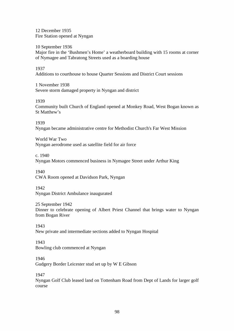
98
12 December 1935 Fire Station opened at Nyngan 10 September 1936 Major fire in the ‘Bushmen’s Home’ a weatherboard building with 15 rooms at corner of Nymagee and Tabratong Streets used as a boarding house 1937 Additions to courthouse to house Quarter Sessions and District Court sessions 1 November 1938 Severe storm damaged property in Nyngan and district 1939 Community built Church of England opened at Monkey Road, West Bogan known as St Matthew’s 1939 Nyngan became administrative centre for Methodist Church's Far West Mission World War Two Nyngan aerodrome used as satellite field for air force c. 1940 Nyngan Motors commenced business in Nymagee Street under Arthur King 1940 CWA Room opened at Davidson Park, Nyngan 1942 Nyngan District Ambulance inaugurated 25 September 1942 Dinner to celebrate opening of Albert Priest Channel that brings water to Nyngan from Bogan River 1943 New private and intermediate sections added to Nyngan Hospital 1943 Bowling club commenced at Nyngan 1946 Gudgery Border Leicester stud set up by W E Gibson 1947 Nyngan Golf Club leased land on Tottenham Road from Dept of Lands for larger golf course
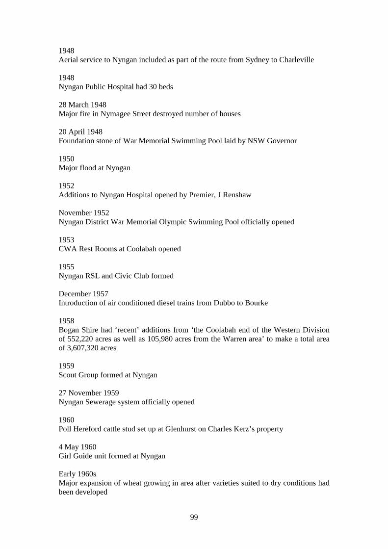
99
1948 Aerial service to Nyngan included as part of the route from Sydney to Charleville 1948 Nyngan Public Hospital had 30 beds 28 March 1948 Major fire in Nymagee Street destroyed number of houses 20 April 1948 Foundation stone of War Memorial Swimming Pool laid by NSW Governor 1950 Major flood at Nyngan 1952 Additions to Nyngan Hospital opened by Premier, J Renshaw November 1952 Nyngan District War Memorial Olympic Swimming Pool officially opened 1953 CWA Rest Rooms at Coolabah opened 1955 Nyngan RSL and Civic Club formed December 1957 Introduction of air conditioned diesel trains from Dubbo to Bourke 1958 Bogan Shire had ‘recent’ additions from ‘the Coolabah end of the Western Division of 552,220 acres as well as 105,980 acres from the Warren area’ to make a total area of 3,607,320 acres 1959 Scout Group formed at Nyngan 27 November 1959 Nyngan Sewerage system officially opened 1960 Poll Hereford cattle stud set up at Glenhurst on Charles Kerz’s property 4 May 1960 Girl Guide unit formed at Nyngan Early 1960s Major expansion of wheat growing in area after varieties suited to dry conditions had been developed
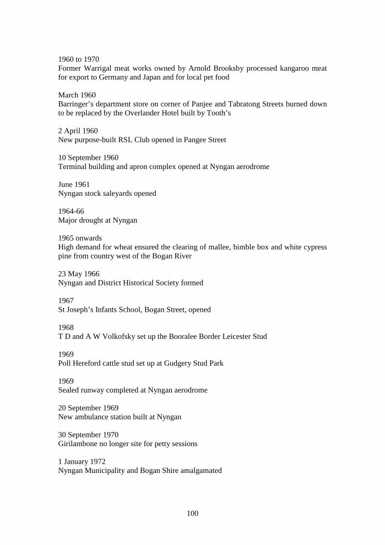
100
1960 to 1970 Former Warrigal meat works owned by Arnold Brooksby processed kangaroo meat for export to Germany and Japan and for local pet food March 1960 Barringer’s department store on corner of Panjee and Tabratong Streets burned down to be replaced by the Overlander Hotel built by Tooth’s 2 April 1960 New purpose-built RSL Club opened in Pangee Street 10 September 1960 Terminal building and apron complex opened at Nyngan aerodrome June 1961 Nyngan stock saleyards opened 1964-66 Major drought at Nyngan 1965 onwards High demand for wheat ensured the clearing of mallee, bimble box and white cypress pine from country west of the Bogan River 23 May 1966 Nyngan and District Historical Society formed 1967 St Joseph’s Infants School, Bogan Street, opened 1968 T D and A W Volkofsky set up the Booralee Border Leicester Stud 1969 Poll Hereford cattle stud set up at Gudgery Stud Park 1969 Sealed runway completed at Nyngan aerodrome 20 September 1969 New ambulance station built at Nyngan 30 September 1970 Girilambone no longer site for petty sessions 1 January 1972 Nyngan Municipality and Bogan Shire amalgamated
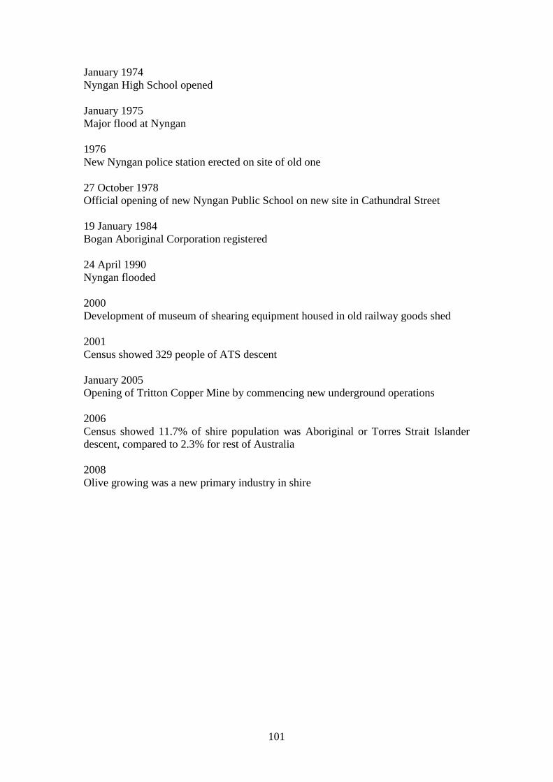
101
January 1974 Nyngan High School opened January 1975 Major flood at Nyngan 1976 New Nyngan police station erected on site of old one 27 October 1978 Official opening of new Nyngan Public School on new site in Cathundral Street 19 January 1984 Bogan Aboriginal Corporation registered 24 April 1990 Nyngan flooded 2000 Development of museum of shearing equipment housed in old railway goods shed 2001 Census showed 329 people of ATS descent January 2005 Opening of Tritton Copper Mine by commencing new underground operations 2006 Census showed 11.7% of shire population was Aboriginal or Torres Strait Islander descent, compared to 2.3% for rest of Australia 2008 Olive growing was a new primary industry in shire
102
3.0 Historical Themes for Bogan Shire Compared with National and State Themes Australian Theme
NSW Theme Local Theme for Bogan Shire
Notes Examples
1 Tracing the natural evolution of Australia
Environment - naturally evolved
The Natural Environment
There are two aspects to this theme: (1) Features occurring naturally in the physical environment which have significance independent of human intervention (2) Features occurring naturally in the physical environment which have shaped or influenced human life and cultures.
A geological formation, fossil site, ecological community, island, soil site, river flats, estuary, mountain range, reef, lake, woodland, seagrass bed, wetland, desert, alps, plain, valley, headland, evidence of flooding, earthquake, bushfire and other natural occurrences.
2 Peopling Australia
Aboriginal cultures and interactions with other cultures
Living in harmony with the land Coping with invasion
Activities associated with maintaining, developing, experiencing and remembering Aboriginal cultural identities and practices, past and present; with demonstrating distinctive ways of life; and with interactions demonstrating race relations.
Place name, camp site, midden, fish trap, trade route, massacre site, shipwreck contact site, missions and institutions, whaling station, pastoral workers camp, timber mill settlement, removed children’s home, town reserve, protest site, places relating to self-determination, keeping place, resistance & protest sites, places of segregation, places of indentured labour, places of reconciliation
2 Peopling Australia
Convict Taking up pastoral land
Activities relating to incarceration, transport, reform, accommodation and working during the convict period in NSW (1788-1850) – does not include activities associated with the conviction of persons in NSW that are unrelated to the imperial ‘convict system’: use the theme of Law & Order for such activities
Prison, convict shipwreck, convict system document, ticket-of-leave and probationary living quarters, guards uniform, landscapes-of-control, lumber yard, quarry, gallows site, convict-built structure, convict ship arrival site, convict barracks, convict hospital, estate based on convict labour, place of secondary punishment.
103
Australian Theme
NSW Theme Local Theme for Bogan Shire
Notes Examples
2 Peopling Australia
Ethnic influences
Diversifying the community
Activities associated with common cultural traditions and peoples of shared descent, and with exchanges between such traditions and peoples.
Blessing-of-the-fleet site, ethnic community hall, Chinese store, place or object that exhibits an identifiable ethnic background, marriage register, olive grove, date palm plantation, citizenship ceremony site, POW camp, register of ship crews, folk festival site, ethnic quarter in a town.
2 Peopling Australia
Migration Diversifying the community
Activities and processes associated with the resettling of people from one place to another (international, interstate, intrastate) and the impacts of such movements
Migrant hostel, customs hall, border crossing, immigration papers, bus depot, emigrant shipwreck, Aboriginal mission, quarantine station, works based on migrant labour, detention centre.
3 Developing local, regional and national economies
Agriculture Promoting closer settlement
Activities relating to the cultivation and rearing of plant and animal species, usually for commercial purposes, can include aquaculture
Hay barn, wheat harvester, silo, dairy, rural landscape, plantation, vineyard, farmstead, shelterbelt, silage pit, fencing, plough markings, shed, fish farm, orchard, market garden, piggery, common, irrigation ditch, Aboriginal seasonal picking camp.
3 Developing local, regional and national economies
Commerce Supplying retail, financial and professional services
Activities relating to buying, selling and exchanging goods and services
Bank, shop, inn, stock exchange, market place, mall, coin collection, consumer wares, bond store, customs house, trade routes, mint, Aboriginal trading places, Aboriginal ration/blanket distribution points, Aboriginal tourism ventures
3 Developing local, regional and national economies
Communication
Communicating Activities relating to the creation and conveyance of information
Post office, telephone exchange, printery, radio studio, newspaper office, telegraph equipment, network of telegraph poles, mail boat shipwreck, track, airstrip, lighthouse, stamp collection.
104
Australian Theme
NSW Theme Local Theme for Bogan Shire
Notes Examples
3 Developing local, regional and national economies
Environment - cultural landscape
Taking up pastoral land Running livestock Promoting closer settlement Altering the landscape
Activities associated with the interactions between humans, human societies and the shaping of their physical surroundings
A landscape type, bushfire fighting equipment, soil conservation structures, national park, nature reserve, market garden, land clearing tools, evidence of Aboriginal land management, avenue of trees, surf beach, fishing spot, plantation, place important in arguments for nature or cultural heritage conservation.
3 Developing local, regional and national economies
Events All themes Activities and processes that mark the consequences of natural and cultural occurrences
Monument, photographs, flood marks, memorial, ceremonial costume, honour board, blazed tree, obelisk, camp site, boundary, legislation, place of pilgrimage, places of protest, demonstration, congregation, celebration.
3 Developing local, regional and national economies
Exploration Exploring the Bogan region
Activities associated with making places previously unknown to a cultural group known to them.
Explorers route, marked tree, camp site, explorer’s journal, artefacts collected on an expedition, captain’s log, surveyor’s notebook, mountain pass, water source, Aboriginal trade route, landing site, map.
3 Developing local, regional and national economies
Fishing N/a Activities associated with gathering, producing, distributing, and consuming resources from aquatic environments useful to humans.
Fishing boat, whaling station, marine reserve, fisher camp, seafood factory, fish shop, oyster lease, artificial reef, fishing boat wreck, mooring, dock, marina, wharf, fish farm, fish trap
3 Developing local, regional and national economies
Forestry
Working the land Activities associated with identifying and managing land covered in trees for commercial timber purposes.
Forested area, forest reserve, timber plantation, forestry equipment, saw mill, mill settlement, arboretum, charcoal kiln, coppiced trees, forest regrowth, timber tracks, whim.
105
Australian Theme
NSW Theme Local Theme for Bogan Shire
Notes Examples
3 Developing local, regional and national economies
Health Caring for health Activities associated with preparing and providing medical assistance and/or promoting or maintaining the well being of humans
Hospital, sanatorium, asylum, surgical equipment, ambulance, nurses quarters, medical school, baby clinic, hospital therapy garden, landscaped grounds, herbalist shop, pharmacy, medical consulting rooms.
3 Developing local, regional and national economies
Industry Manufacturing - working in workshops, mills or factories
Activities associated with the manufacture, production and distribution of goods
Factory, workshop, depot, industrial machinery, timber mill, quarry, private railway or wharf, shipbuilding yard, slipway, blacksmithy, cannery, foundry, kiln, smelter, tannery, brewery, factory office, company records.
3 Developing local, regional and national economies
Mining Developing mineral wealth
Activities associated with the identification, extraction, processing and distribution of mineral ores, precious stones and other such inorganic substances.
Mine, quarry, race, mining field or landscape, processing plant, manager’s office, mineral specimen, mining equipment, mining license, ore laden shipwreck, collier, mine shaft, sluice gate, mineral deposit, slag heap, assay office, water race.
3 Developing local, regional and national economies
Pastoralism Taking up pastoral land Running livestock
Activities associated with the breeding, raising, processing and distribution of livestock for human use
Pastoral station, shearing shed, slaughter yard, stud book, photos of prize-winning stock, homestead, pastoral landscape, common, fencing, grassland, well, water trough, freezer boat shipwreck, wool store.
3 Developing local, regional and national economies
Science Excelling artistically or technically
Activities associated with systematic observations, experiments and processes for the explanation of observable phenomena
Laboratory, experimental equipment, text book, observatory, botanical garden, arboretum, research station, university research reserve, weather station, soil conservation area, fossil site, archaeological research site.
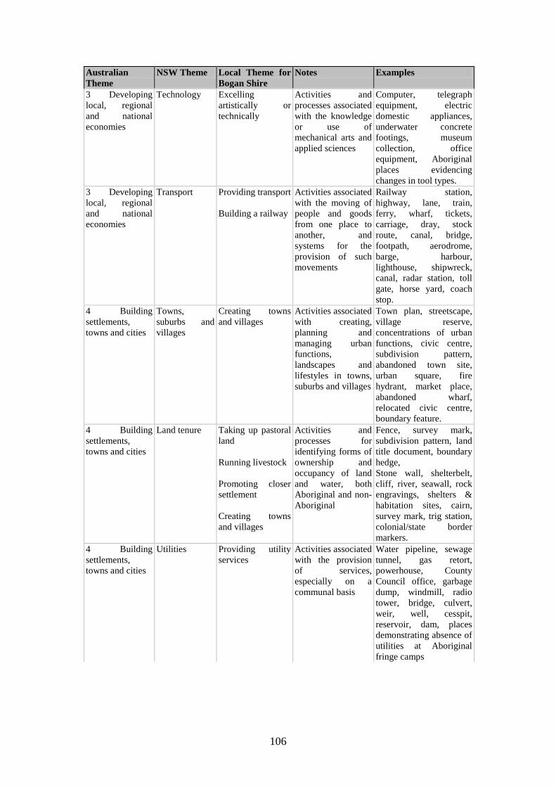
106
Australian Theme
NSW Theme Local Theme for Bogan Shire
Notes Examples
3 Developing local, regional and national economies
Technology Excelling artistically or technically
Activities and processes associated with the knowledge or use of mechanical arts and applied sciences
Computer, telegraph equipment, electric domestic appliances, underwater concrete footings, museum collection, office equipment, Aboriginal places evidencing changes in tool types.
3 Developing local, regional and national economies
Transport Providing transport Building a railway
Activities associated with the moving of people and goods from one place to another, and systems for the provision of such movements
Railway station, highway, lane, train, ferry, wharf, tickets, carriage, dray, stock route, canal, bridge, footpath, aerodrome, barge, harbour, lighthouse, shipwreck, canal, radar station, toll gate, horse yard, coach stop.
4 Building settlements, towns and cities
Towns, suburbs and villages
Creating towns and villages
Activities associated with creating, planning and managing urban functions, landscapes and lifestyles in towns, suburbs and villages
Town plan, streetscape, village reserve, concentrations of urban functions, civic centre, subdivision pattern, abandoned town site, urban square, fire hydrant, market place, abandoned wharf, relocated civic centre, boundary feature.
4 Building settlements, towns and cities
Land tenure Taking up pastoral land Running livestock Promoting closer settlement Creating towns and villages
Activities and processes for identifying forms of ownership and occupancy of land and water, both Aboriginal and non-Aboriginal
Fence, survey mark, subdivision pattern, land title document, boundary hedge, Stone wall, shelterbelt, cliff, river, seawall, rock engravings, shelters & habitation sites, cairn, survey mark, trig station, colonial/state border markers.
4 Building settlements, towns and cities
Utilities Providing utility services
Activities associated with the provision of services, especially on a communal basis
Water pipeline, sewage tunnel, gas retort, powerhouse, County Council office, garbage dump, windmill, radio tower, bridge, culvert, weir, well, cesspit, reservoir, dam, places demonstrating absence of utilities at Aboriginal fringe camps
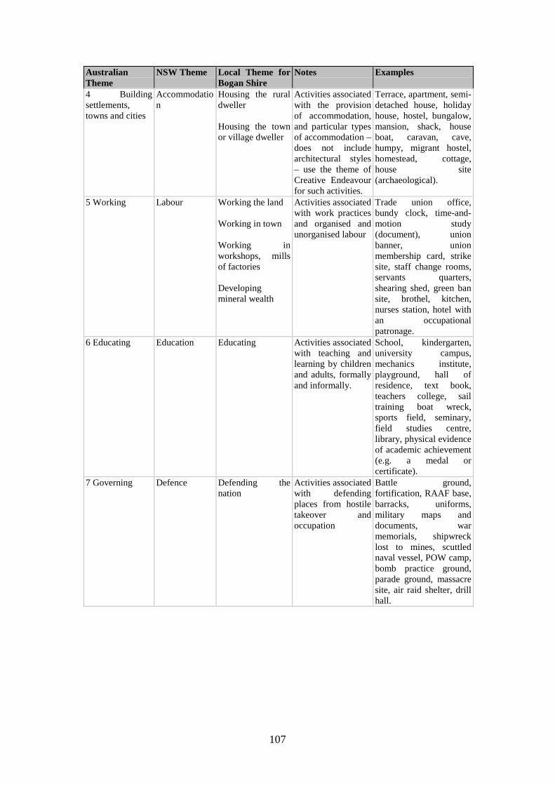
107
Australian Theme
NSW Theme Local Theme for Bogan Shire
Notes Examples
4 Building settlements, towns and cities
Accommodation
Housing the rural dweller Housing the town or village dweller
Activities associated with the provision of accommodation, and particular types of accommodation – does not include architectural styles – use the theme of Creative Endeavour for such activities.
Terrace, apartment, semi-detached house, holiday house, hostel, bungalow, mansion, shack, house boat, caravan, cave, humpy, migrant hostel, homestead, cottage, house site (archaeological).
5 Working Labour Working the land Working in town Working in workshops, mills of factories Developing mineral wealth
Activities associated with work practices and organised and unorganised labour
Trade union office, bundy clock, time-and-motion study (document), union banner, union membership card, strike site, staff change rooms, servants quarters, shearing shed, green ban site, brothel, kitchen, nurses station, hotel with an occupational patronage.
6 Educating Education Educating Activities associated with teaching and learning by children and adults, formally and informally.
School, kindergarten, university campus, mechanics institute, playground, hall of residence, text book, teachers college, sail training boat wreck, sports field, seminary, field studies centre, library, physical evidence of academic achievement (e.g. a medal or certificate).
7 Governing Defence Defending the nation
Activities associated with defending places from hostile takeover and occupation
Battle ground, fortification, RAAF base, barracks, uniforms, military maps and documents, war memorials, shipwreck lost to mines, scuttled naval vessel, POW camp, bomb practice ground, parade ground, massacre site, air raid shelter, drill hall.
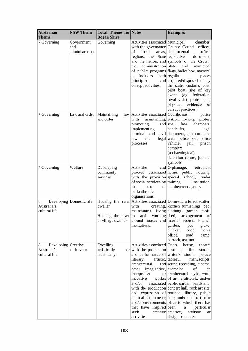
108
Australian Theme
NSW Theme Local Theme for Bogan Shire
Notes Examples
7 Governing Government and administration
Governing Activities associated with the governance of local areas, regions, the State and the nation, and the administration of public programs – includes both principled and corrupt activities.
Municipal chamber, County Council offices, departmental office, legislative document, symbols of the Crown, State and municipal flags, ballot box, mayoral regalia, places acquired/disposed of by the state, customs boat, pilot boat, site of key event (eg federation, royal visit), protest site, physical evidence of corrupt practices.
7 Governing Law and order Maintaining law and order
Activities associated with maintaining, promoting and implementing criminal and civil law and legal processes
Courthouse, police station, lock-up, protest site, law chambers, handcuffs, legal document, gaol complex, water police boat, police vehicle, jail, prison complex (archaeological), detention centre, judicial symbols
7 Governing Welfare Developing community services
Activities and process associated with the provision of social services by the state or philanthropic organisations
Orphanage, retirement home, public housing, special school, trades training institution, employment agency.
8 Developing Australia’s cultural life
Domestic life Housing the rural dweller Housing the town or village dweller
Activities associated with creating, maintaining, living in and working around houses and institutions.
Domestic artefact scatter, kitchen furnishings, bed, clothing, garden tools, shed, arrangement of interior rooms, kitchen garden, pet grave, chicken coop, home office, road camp, barrack, asylum.
8 Developing Australia’s cultural life
Creative endeavour
Excelling artistically or technically
Activities associated with the production and performance of literary, artistic, architectural and other imaginative, interpretive or inventive works; and/or associated with the production and expression of cultural phenomena; and/or environments that have inspired such creative activities.
Opera house, theatre costume, film studio, writer’s studio, parade tableau, manuscripts, sound recording, cinema, exemplar of an architectural style, work of art, craftwork, and/or public garden, bandstand, concert hall, rock art site, rotunda, library, public hall; and/or a, particular place to which there has been a particular creative, stylistic or design response.
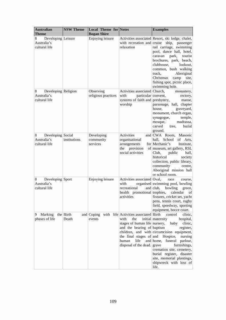
109
Australian Theme
NSW Theme Local Theme for Bogan Shire
Notes Examples
8 Developing Australia’s cultural life
Leisure Enjoying leisure
Activities associated with recreation and relaxation
Resort, ski lodge, chalet, cruise ship, passenger rail carriage, swimming pool, dance hall, hotel, caravan park, tourist brochures, park, beach, clubhouse, lookout, common, bush walking track, Aboriginal Christmas camp site, fishing spot, picnic place, swimming hole.
8 Developing Australia’s cultural life
Religion Observing religious practices
Activities associated with particular systems of faith and worship
Church, monastery, convent, rectory, presbytery, manse, parsonage, hall, chapter house, graveyard, monument, church organ, synagogue, temple, mosque, madrassa, carved tree, burial ground.
8 Developing Australia’s cultural life
Social institutions
Developing community services
Activities and organisational arrangements for the provision of social activities
CWA Room, Masonic hall, School of Arts, Mechanic’s Institute, museum, art gallery, RSL Club, public hall, historical society collection, public library, community centre, Aboriginal mission hall or school room.
8 Developing Australia’s cultural life
Sport Enjoying leisure Activities associated with organised recreational and health promotional activities
Oval, race course, swimming pool, bowling club, bowling green, trophies, calendar of fixtures, cricket set, yacht pens, tennis court, rugby field, speedway, sporting equipment, bocce court.
9 Marking the phases of life
Birth and Death
Coping with life events
Activities associated with the initial stages of human life and the bearing of children, and with the final stages of human life and disposal of the dead.
Birth control clinic, maternity hospital, nursery, baby clinic, baptism register, circumcision equipment, and Hospice, nursing home, funeral parlour, grave furnishings, cremation site, cemetery, burial register, disaster site, memorial plantings, shipwreck with loss of life.
110
Australian Theme
NSW Theme Local Theme for Bogan Shire
Notes Examples
9 Marking the phases of life
Persons All themes
Activities of, and associations with, identifiable individuals, families and communal groups
A monument to an individual, a family home, a dynastic estate, private chapel, a birthplace, a place of residence, a gendered site, statue, commemorative place name, place dedicated to memory of a person (e.g. hospital wing).
111
Bibliography MAPS – STATE RECORDS OF NSW Cannonbar village design on Duck Creek, (C.1943), R J Campbell, 1866, SR Map 2441 Plan of the village of Canonba on Duck Creek, Co Gregory, District of Wellington (C.1943.a), 1866, SR Map 2442 Canonba Village, Co Gregory (SG), 1866, SR Map 2443 Nyngan, Preliminary Survey, (N.2282a), MacFarlane, 1881, SR Map 4660 Stations and reserves as proposed in Wellington district, along north side, Lachlan River, (W.2a.1322) Davidson, (29 September 1852), SR Map 5996 Plans of Gunningba, Belleringa and Duck Creeks, tributaries of Bogan River, Davidson, (W.26-30.1322) 16 April 1852, SR Maps 6018-22 County Canbelego, nd (Mines) SR Map 11039 County Gregory, ‘12/6/76’, SR Map 18802 County Oxley, 1881, SR Map 24584 County Oxley, 1887, SR Map 24591 MAPS – MITCHELL LIBRARY King, Charles W, Plan of the Town of Girilambone Being the subdivision of Portions No 6, 7, and 8, 1880, Z M3 816.219/GIRILAMBONE/1880/1 Country Property Maps
County Canbelego, ZCP:C1c/1-4 County Cowper, ZCP:C5c/1-6a County Flinders, ZCP:F8a/1 County Gregory, ZCP:G7/1-11 County Oxley, ZCP:O1/1-3
Town Maps
Canonba 1866
112
Carpina (none) Girilambone, 1903 Hermidale, 1933 Nyngan 1882, 1933
County Maps
County Canbelego, 1901, 1909 County Cowper, 1899, 1928 County Flinders, 1901, 1907 County Gregory, 1906, 1907, 1933 County Oxley 1902, 1907, 1935
MAPS – NATIONAL LIBRARY OF AUSTRALIA MacDonald, A C, Map of the colony of New South Wales showing land division, railways, … and names of runs, Melbourne, 1883, NLA Map Room 666 MacDonald, D, Map of New South Wales showing stock routes, tanks, wells and trucking stations, Melbourne, NLA Map Room 3193 Reuss and Browne’s map of New South Wales and part of Queensland showing the relative positions of pastoral runs, squattages, districts, counties, towns, reserves, etc, 186-, Map NK 5928 LAND AND PROPERTY MANAGEMENT Certificates of Title, 1863 onwards Plans CROWN PLANS – LPMA 1519 Wellington Pre-emptive District (Purchases)
W.32.1519 John Brown W.33.1519 Charles York
1834 Alienation Act of 1861 Miscellaneous Reserves
W.117.1834 (Portion 1, Parish Nirranda, Hermitage Govt Tank)
113
1907 Gregory County
G.1.1907 Canonba Reserve G.2.1907 John Brown’s purchase G.10.1907 Portions near Canonba G.77.1907
1943 Canonba Village C.1.1943 Village, 31 Aug 1866 C.2.1943 Village, 18 Dec 1867
1950 Flinders County 2000 Oxley County
O.278.2000 (Por 1 Parish Nyngan) O.279.2000 (Por 2 Parish Nyngan) O.297.2000 (Por 3 & 4 Parish Nyngan) O.723.2000 O.872.2000 (Por 79 Parish Kungerbil – Warrigal Freezing Works) O.1168.2000
2146 Canbelego County
C.1.2146 C.13.2146 (Por 2/78 Parish Gidalambone) C.19.2146 (Por 1, Parish Hermitage) C.30.2146 (Por 6 Parish Gidalambone) C.117.2146 (Por 1, Parish Vega) C.355.2146 (Por 10-19 Parish Coreen 11 Nov 1915)
2282 Nyngan Village
N.3.2282
114
N.6.2282
2296 Girilambone Village 2771 Carpina (Parish Cameron Co Flinders) DEPARTMENT OF MINERAL RESOURCES Mine Record
MR 399 Bonnie Dundee Mine, Budgerygar, Coolabah, 1901-87 MR 433, Miandetta Mine, Hermidale, 1908 MR 437 Budgery Copper Mine, Hermidale, 1895-1980 MR 449 Overflow Mine, Bobadah, 1894-1979 MR 517 Girilambone Copper Mine, Coolabah, 1897-1970 MR 2257 True Blue Gold Mine, Hermidale, 1922-35
Manuscript Sources – National Archives of Australia A 9716, Department of Air, Central Office, Acquisition and operational files of the RAAF Directorate of Works and Buildings and Engineer Intelligence Section
1541 RAAF Directorate of Works and Buildings – NSW airfield data sheets, 1943-44
SP 32/1 Post Office Files
Bobadah Part 1, 1897-1901 Cannonbar, Part I, 1857-68 Girilambone, 1876-1883, pt 1
Manuscript Sources – State Records 1901 Census, Collector’s Books, Nyngan, Book 58 Board of Fire Commissioners, Information relating to fire stations, c. 1955 - card index 14/1737.2 Education, School Files
Cannonbar, 1876-1888, 5/15272.1
115
Girilambone, 1881-1903, 5/15993.2 Hermidale, 1932ff, 5/16264.1
Lands, Registers of Improved Purchases, 1882-92, 7/4263; 1893-1909 7/425 Lands, Miscellaneous Branch, Correspondence
Ms 87/10865 (IP Geweroo run), 10/3770 Lands, Miscellaneous Lease Branch, Correspondence
MsLs96/8055 (Scrub Lease application 96/2 Nyngan) 10/111207 Lands, Occupation Branch, Registers of Run Boundary Files, Wellington District, 1878-84, 8/2212 Lands, Occupation Branch, Run Boundary Files, Wellington District,
No 134 Darouble East, 8/2417 No 135 Darouble East Back, 8/2417 No 144, Duck Creek, 8/2417 No 296, Nyngan East, 8/2419
Lands, Occupation Branch, Correspondence
Occ82/3238 (Sp.L application, G B Wray, store) 14/4447 Occ82/3239 (Sp.L application, George Saville, hotel) 14/4447 Occ82/3915 (Sp.L application, Alison & Sons, sawmill, Co Canbelego) 14/4447 Occ84/3047 (permissive occupancy Girilambone) 14/4454 Occ86/879 (Sp.L Mercantile Bank, Nyngan) 14/4464
Lands, Occupation Branch, Tracings of Runs, 1881-4
4/7058 Includes Wellington District Lands, Occupation Branch, Occupation Licences
No 145, Nyngan East, 3/5019 No 153, Colane, 3/5020
116
Lands, Roads Branch, Plan Catalogue Books, 2/36-2/40 Lands, Roads Branch, Correspondence
Rds 95/74 (road Nyngan to Cobar R.1992a.1603) 10/15378 Lands, Sales, Conditional Purchase Registers
Dubbo, 7/2898
Lands, Lands Office, Conditional Sales, Correspondence
CS 83/2346Cor (Portion 77 Parish Bergo) 10/20755 Lands and Public Works Department, Correspondence
Lds&PW58/1726 (Aboriginal attacks Bogan River) 5/3588 Lds&PW58/3642 (Aboriginal attacks Bogan River) 5/3593
Licences Reduction Board, Hotel Cards, 1920-37, Sturt District, 3/7886 Public Works Dept, Public Watering Place Files
No 439 Hermidale Tank 7/1428 Public Works Dept, Correspondence Files
Canonba Lock-up 1863-4, 2/584 Registrar-General, Registers of Firms
2/8536 Stamp Duties Office, Deceased Estate Files,
Duty paid series
Brown, John, Emu Plains, died 21/8/1888, duty paid 15/7/90, 20/20 Bleakley, A T, died 5/1/1896, duty paid 6/6/96, 20/94
Supreme Court, Bankruptcy Files
Cassin, Mammon, Nyngan, 13 Oct 1894, No 8922, 10/22987 Joubert, J E, Nyngan, woolscourer, 31 March 1896, No 10753 10/23091
117
Surveyor-General, Letters Received,
SG 58/3046 (Pre-emptive purchase, Charles York) 5/5523 SG58/6869 (Pre-emptive purchase, John Brown, Canonba) 5/5535
Surveyor-General, Sketchbooks, X751-X778 Surveyor-General, Catalogue of Pre-emptive purchase plans, 1850-75, 4/6182 Treasury, Certificates of Depasturing Licences, 1837-46, 1851, 4/91-4/108, 4/112 VOTES AND PROCEEDINGS OF THE LEGISLATIVE ASSEMBLY OF NEW SOUTH WALES ‘Crown Lands (Under lease or licence beyond the Settled Districts’, 1859-60, volume 3, p 635ff ‘Crown Lands (Held under pastoral occupation)’, 1865-66, volume 3, p 205-76 ‘Crown Lands (Proposals with respect to the conversion of certain pastoral leases … Land Board District of Dubbo …)’, 1895, volume 3, pp 123-8 GOVERNMENT PUBLICATIONS Australia, Census, 1911, 1921, 1933, 1947, 1954, 1961 Australia, Electoral Rolls, 1903, Electoral District of Cobar Australian Bureau of Statistics, 1991 Census of Population and Housing - Type of Dwellings in Statistical Local Areas in NSW, 1992 Bureau of Census and Statistics, Census of population and housing 30 June 1971, Bulletin 7, Characteristics of the Population and Dwellings in Local Government Areas and Urban Centres, Part 1, New South Wales (No 2.89.1) Bureau of Census and Statistics, The Aboriginal Population – Australia, 1971, (Ref 2.91) Australian Bureau of Statistics, Census 2001 – NSW Selected social and housing characteristics, NSW, 2015.1 Blue Book of New South Wales, 1856-1910 NSW - Department of Lands, Annual Reports, 1906-1916 NSW - Department of Main Roads, The Roadmakers - A History of Main Roads in New South Wales, Department of Main Roads, Sydney, 1976 NSW - Department of Mines, Annual Reports, 1875-1960

118
NSW - Department of Public Works, Annual Reports, 1889ff NSW – Dept of School Education, Government Schools of New South Wales 1848 to 1993, Dept of School Education, 1993, Sydney NSW – Premiers Department, Division of Reconstruction and Development, The Macquarie Region: A preliminary survey of resources, Government Printer, Sydney, 1948 NSW - Water Resources Commission, The Role of Water in the Development of New South Wales, Sydney, July 1984 NSW – Dept of Water Resources, Water Resources of the Castlereagh, Macquarie and Bogan valleys, Dept, Parramatta 1991 NSW - Water Resources and Irrigation Commission, The Water Resources of the Macquarie Valley including the Bogan River, Survey of Thirty NSW River Systems, No 6, Dec 1966 NSW, Census, 1891, 1901 New South Wales Government Gazette, 1831 to date Official Year Book of New South Wales, 1904-05; 1917, Government Printer, Sydney Newspapers Australian Town and Country Journal, 1885 Illustrated Sydney News Sydney Mail Sydney Morning Herald Primary Sources – Printed Books and Articles Australian Men of Mark, C F Maxwell, Sydney, 1888-9 Back to Nyngan Executive Committee, ‘Back to Nyngan’ Week 24th September to 29th September 1928: Official Souvenir, Regent Press, Sydney for the Committee Bailliere's New South Wales Gazetteer and Road Guide, Sydney, 1870 Bogan Shire Council, Annual Report, 1995-2008 Carne, J E, The Copper-Mining Industry and the Distribution of Copper Ores in New South Wales, Dept of Mines and Agriculture, Mineral Resources No 6, Sydney, 1908
119
Hanson, William, The Pastoral Possessions of New South Wales, Gibbs Shallard & Co, Sydney, 1889 Merchants' and Traders' Association Pty Ltd, Country Trade Directory, July 1938 Milne, Edmund, ‘War on the Bogan Frontier’, Lone Hand, June 1917, pp 339-41 NSW - Grain Elevators Board, Report, 1966-7 Sands, John, NSW Directory, 1900-1932/3, Sydney Walter Samson & Co’s New South Wales National Directory for 1867-8, W J Meyer, Sydney, 1867 Yewen's Directory of the Landholders of New South Wales, 1900, Farm & Dairy Publishing Co, Sydney, 1900 Secondary Sources Bennett, J M, A History of the Supreme Court of New South Wales, Law Book Co, Sydney, 1974 Birmingham, Judy, Ian Jack, Dennis Jeans, Australian Pioneer Technology: Sites and relics, Heineman, Melbourne, 1979 Branagan, David F and Gordon H Packham, Field Geology of New South Wales, Science Press, Sydney, second edition, 1970 Bridges, Peter, Historic Court Houses of New South Wales, Hale & Iremonger, Sydney, 1986 Butlin, N. G. Investment in Australian Economic Development 1861-1900, Cambridge University Press, Cambridge, 1964 Campbell H E O, History of Nyngan 1883-1958, Nyngan Observer, Nyngan, Dec 1958 Campbell, J F, 'Squatting' on Crown Land in New South Wales, Royal Australian Historical Society, Sydney, 1968 Connolly, C. N., Biographical Register of the New South Wales Parliament 1856-1901, Australian National University Press, Canberra, 1983 Crundwell, Robert, Hilary Golder & Robert Wood, From Parchments to Passwords: A History of the Land Titles Office of New South Wales, Hale & Iremonger, Sydney, 1995 Deutsher, Keith M, The Breweries of Australia: A History, Lothian, Melbourne, 1999
120
Farrer, K T H, A Settlement Amply Supplied: Food technology in nineteenth century Australia, Melbourne University Press, Melbourne, 1980 Foster, William C, Sir Thomas Livingston Mitchell and his world, 1792-1855: Surveyor General of New South Wales, 1828-1855, Institution of Surveyors, NSW, Sydney, 1985 Gibbney, H J & A G Smith, A Biographical Register 1788-1939, Anutech, Canberra, 1987 Gibson, Wilfred et al, Nyngan on the Bogan: Centenary Year 1983, Nyngan Historical Society, Nyngan, 2nd edition, November 1983 Golder, Hilary, High and Responsible Office: A History of the NSW Magistracy, Sydney University Press, Sydney, 1991 Goodall, Heather, Invasion to Embassy: Land in Aboriginal Politics in New South Wales, 1770-1972, Allen & Unwin, St Leonards, 1996 Griffiths, Noel, A History of the Government Savings Bank of New South Wales, Sydney, 1930 Gunn, John, Along Parallel Lines: A history of the railways of New South Wales, Melbourne University Press, Melbourne, 1989. Heckendorf, K H, Girilambone 100 Years, Dubbo Secretarial Services, Dubbo, Oct 1980 Regional Histories of New South Wales, (written by R Ian Jack & Dennis N Jeans), Heritage Office and Dept of Urban Affairs and Planning, Sydney, October 1996 Jeans, D N, An Historical Geography of New South Wales to 1901, Reed, Sydney, 1972 Kass, Terry, Jewels in the Crown: A History of the Bridge Street Plan Room and Crown Plans, NSW Dept of Lands, Bathurst, 2008 Kass, Terry, Sails to Satellites: The Surveyors General of NSW (1786-2007), NSW Dept of Lands, Bathurst, 2008 King, C J, An Outline of Closer Settlement in New South Wales, Part 1, The Sequence of the Land Laws 1788-1956, NSW Dept of Agriculture, Div of Marketing and Agricultural Economics, Sydney, 1957 Lang, Andrew G, Crown Land in New South Wales, Butterworths, Sydney, 1973 Linge, G J R, Industrial Awakening - A Geography of Australian Manufacturing 1788 to 1890, Australian National University Press, Canberra, 1979
121
Lloyd, C J, Either Drought or Plenty: Water Development and Management in New South Wales, Dept of Water Resources, NSW, Parramatta, 1988 Pierce, Peter (ed), The Oxford Literary Guide to Australia, Oxford University Press, Melbourne, 1993 Rolls, Eric, They All Ran Wild: The story of pests on the land of Australia, Angus & Robertson, paperback, London, 1977 Shelly, Darren, Flora and Fauna of Coolabah District, DLWC and Coolabah Landcare Group, Dubbo, 2000 Simmonds, Diane de St Hilaire, Cobb & Co Heritage Trail Bathurst to Bourke, Sept 1999 Thompson, Phillip ‘Bluey’, Under the shade of the Coolibah tree: A History of Coolabah Village Incorporating the centenary of Coolabah Public School 1887-1987, Author, 1987 Tindale, Norman B, Aboriginal tribes of Australia; their terrain, environmental controls, distribution, limits and proper names, Australian National University Press, Canberra 1974 Wright, Don and Eric Clancy, The Methodists: A History of Methodism in NSW, Allen & Unwin, St Leonards, 1993 UNPUBLISHED REPORTS, THESES, ETC Coltheart, Lenore, A Guide to the History of the Public Works Department, New South Wales, PWD Heritage Group, Sydney, 1991