Embed Size (px)
Citation preview
Book of abstracts
VLIZ Young Scientists’ Day
Brugge, Belgium 29 February 2008
VLIZ Special Publication 40 2008
ii
Deze publicatie dient als volgt geciteerd te worden:
Mees, J.; Seys J., eds (2008). VLIZ young scientists’ day, Brugge, Belgium, 29 February 2008: VLIZ Special Publication, 40. Vlaams Instituut voor de Zee (VLIZ): Oostende, Belgium. ix + 96 pp.
Vlaams Instituut voor de Zee Flanders Marine Institute VLIZ – InnovOcean site Wandelaarkaai 7 B-8400 Oostende, Belgium Tel. +32-(0)59-34 21 30 Fax +32-(0)59-34 21 31 E-mail: [email protected] http://www.vliz.be
Niets uit deze uitgave mag worden verveelvoudigd en/of openbaar gemaakt door middel van druk, fotokopie, microfilm of op welke andere wijze ook zonder voorafgaandelijke schriftelijke toestemming van de uitgever.
ISSN 1377-0950
iii
Preface
The Flanders Marine Institute (VLIZ) supports marine scientific research in Flanders. VLIZ offers logistic support, promotes expertise internationally, and serves as an interface between the scientific community, governmental bodies, and the public at large. VLIZ wants to give exposure to marine, coastal and estuarine research in Flanders, whereby coordination and dissemination of information play key roles.
Marine research in Flanders is carried out by the six Flemish universities, research institutes and departments of the Flemish and federal authorities, and to a lesser extent by private enterprises. The major broad disciplines covered are: biology, earth sciences, chemistry, physics, aquaculture and fisheries, engineering, and maritime affairs. Annually, VLIZ bundles the scientific contributions of the Flemish marine researchers in the ‘VLIZ Collected Reprints’. VLIZ increases the visibility of marine research in Flanders by producing publications, organizing symposia and granting scientific awards.
On Friday, 29 February 2008, the eighth ‘VLIZ Young Scientists’ Day’ (170 pre-registered participants) was organized in Provinciehuis Boeverbos, Sint-Andries (Brugge), Belgium.
Programme:
two plenary lectures by senior scientists four oral presentations by young scientists
poster competition for young scientists
photo contest
demonstrations of marine and coastal databases and services
presentation by laureates of ‘VLIZ aanmoedigingsprijzen mariene wetenschappen 2007’ and ‘Annual VLIZ North Sea Award 2007’
This ‘VLIZ Special Publication 40’ comprises the abstracts of the oral, poster and demo presentations as well as the summaries submitted by the laureates and applicants of the ‘VLIZ aanmoedigingsprijzen mariene wetenschappen 2007’ and ‘Annual VLIZ North Sea Award 2007’.
Dr Jan Mees Director VLIZ
v
Table of Contents
Laureates Annual VLIZ Thesis Awards Marine Sciences 2007
Demaerel Virginie, Steven Degraer, Magda Vincx and Thomas Remerie. Research into the distribution of the genus Bathyporeia (Crustacea, Amphipoda) by means of molecular markers .................................................................................................. 2
Denys Sarah. De contrasterende Holocene sediment successie langsheen het westelijk en oostelijk deel van de Belgische kust: oorzaak en gevolgen. (The contrasting Holocene sediment succession along the western and eastern part of the Belgian coast: cause and consequences)............................................................................... 4
Laureate Annual VLIZ North Sea Award 2007
Vandendriessche Sofie. Floating seaweed as ephemeral neustonic habitat ............................ 13
Oral presentations Van Grieken René. The air quality over the North Sea: has it changed over the last thirty
years?.................................................................................................................. 18
Maes Gregory and Filip Volckaert. Is the European eel slipping away towards extinction? A review of research and management challenges ................................... 19
De Backer Griet, Charlotte Beels and Julien De Rouck. Waves in the North Sea: powering our future?............................................................................................. 20
Seys Jan and Evy Copejans. Marine science and education in one word: ‘planeetzee.org’.................................................................................................... 21
Du Four Isabelle, Els Verfaillie and Vera Van Lancker. Mapping the seabed of the Belgian part of the North Sea to assist in a science-based approach to management ........................................................................................................ 22
Lindeboom Han. The North Sea, past and present: shifting baselines and human uses .......... 24
Poster & demo presentations
Anseeuw Dieter, Kelle Moreau, Sofie Vandemaele and Sofie Vandendriessche. Discarding in beam trawl fisheries: quantification and reduction (preliminary results) ................................................................................................................. 26
vi
Appeltans Ward, Mark J. Costello, Bart Vanhoorne, Wim Decock, Leen Vandepitte, Francisco Hernandez, Jan Mees and Edward Vanden Berghe. Aphia for a World Register of Marine Species (WoRMS)....................................................................... 27
Bauwens Maite, Fabrice Servaes, Veerle Beelaerts, Céline Poulain, Philippe Dubois, Johan Schoukens and Frank Dehairs. Climate reconstruction based on archaeological bivalve shells.................................................................................. 28
Belpaeme Kathy, Hannelore Maelfait and Sylvia Theunynck. The coast, a matter of balance: an inside view on the Coordination Centre on Integrated Coastal Zone Management........................................................................................................ 29
Beyst Bregje and Melissa Prosec. The Scheldt InformationCenter: an information platform for the estuary of the River Scheldt ............................................................. 31
Boden Gert, Tobias Musschoot and Jos Snoeks. FishBase: the on-line answer to ichthyological issues .............................................................................................. 32
Braeckman UIrike, Provoost Pieter, Britta Gribsholt, Jack Middelburg, Karline Soetaert, Magda Vincx and Jan Vanaverbeke. The role of macrofauna in the functioning of a sea floor: is there any seasonal, density or functional identity effect? ................... 33
Cattrijsse André and Jan Mees. Flanders Builds new research vessel ‘Simon Stevin’ ............... 34
Claessens Michiel, Els Monteyne, Patrick Roose and Colin Janssen. The use of integrative passive samplers as a source of contaminant mixtures in ecotoxicological laboratory experiments .................................................................. 36
Claessens Michiel, Karen Rappé, Els Monteyne, Klaas Wille, Herlinde Noppe, Magda Vincx, Hubert De Brabander, Patrick Roose, Jan Mees and Colin Janssen. INRAM – Integrated Risk Assessment and Monitoring of micropollutants in the Belgian coastal zone ............................................................................................. 37
Claus Simon, Bart Vanhoorne and Francisco Hernandez. The Coastal and Marine Wiki: an Internet encyclopaedia providing up-to-date quality information for and by coastal and marine professionals............................................................................ 38
Cocquyt Ellen, Frederik Leliaert, Heroen Verbruggen and Olivier De Clerck. Hunting for nuclear markers in green algal lineages: molecular evolution of glucose-6-phosphate isomerase ............................................................................................ 40
Cuveliers Els, Gregory Maes, Audrey Geffen and Filip Volckaert. Elemental composition of sole otoliths as a population discrimination tool ................................................... 41
De Baere Kris, Helen Verstraelen, Willy Schillemans, Raf Dewil and Geert Potters. Study of chemical and microbial factors affecting the corrosion in ballast tanks on board of merchant navy vessels .............................................................................. 42
vii
de Brye B., E. Deleersnijder, A. de Brauwere, O. Gourgue, J. Passerat and P. Servais. Finite element modelling of the Scheldt Estuary and the adjacent Belgian/Dutch coastal zone with application to the transport of fecal bacteria .................................. 43
De Cauwer Karien, Mia Devolder, Siegrid Jans, Angelino Meerhaeghe and Serge Scory. Online data services at the Belgian Marine Datacentre ................................... 44
De Wever Aaike, Rodney Forster and Koen Sabbe. Microphytobenthos production and biomass monitoring on intertidal mudflats using remote sensing ................................ 45
Dujardin Arvid, Joris Vanlede and Youri Meersschaut. Human and environmental effects on the top of the mud layer in the entrance of the Zeebrugge harbour ....................... 46
Goffin Annelies, Klaas Deneudt, Sherley Rosseel and Francisco Hernandez. Upgrading the OMES database: online access to OMES monitoring data using the IMERS web interface........................................................................................................ 47
Guilini Katja and Ann Vanreusel.The trophodynamic role of nematode communities in the ecology of different deep-sea environments........................................................ 48
Haspeslagh Jan, Roeland T'Jampens and Sherley Rosseel. OMA – The Open Marine Archive for Flemish marine research: facts and figures .............................................. 49
Hernandez Francisco, Klaas Deneudt and Johan Mares. Marine Data Archive ...................... 50
Jacobs Werner, Dirk Dubois, Diane Aerts, Niels Tobac, Roel Cerneels, René Van Grieken and Anna Buczynska. Mapping of toxic vapors on board of chemical tankers................................................................................................................. 51
Lambrechts Jonathan, Eric Deleersnijder, Vincent Legat and Eric Wolanski. Finite-element model of the Great Barrier Reef Circulation................................................. 52
Larmuseau Maarten H.D., Jeroen K.J. Van Houdt, Jef Guelinckx, Bart Hellemans and Filip A.M. Volckaert. Deep genetic divergence and recent radiations in sand goby Pomatoschistus minutus along European coasts ............................................... 53
Lenartz Fabian, Jean-Marie Beckers, Salim Djenidi and Marilaure Grégoire. Hydrodynamics and ecosystem dynamics in the Bay of Calvi ..................................... 54
Lescrauwaet Ann-Katrien, Heidi Debergh, Sara Behiels, Francisco Hernandez and Jan Mees. Belgian sea fisheries statistics: compiling historical data to recover a wider perspective ........................................................................................................... 55
Lescrauwaet Ann-Katrien, An Vanhoorne, Sylvie Braekevelt, Fien Van Coillie, Kristien Veys, Francisco Hernandez and Jan Mees. ‘SeaStats’: hard figures on sea and coast ................................................................................................................... 56
Mas Rémy, Céline Poulain, Philippe Claeys, Frank Dehairs and Edward Keppens. Stable isotope (C, N) composition of bivalve shell organic matter and salinity....................... 57
viii
Munga C.N., A. Vanreusel, D. Obura, F. Dahdouh-Guebas, M.O. Mohamed and N. Amiyo. Algal turf dominates Mombasa Marine Park and Reserve in Kenya, an implication of nutrient pollution .............................................................................. 58
Neukermans Griet and Kevin Ruddick. High temporal resolution mapping of total suspended matter in Belgian coastal waters with SEVIRI data: a feasibility study........... 59
Pauly Klaas and Eric Coppejans. Putting geography into phycology: recent advances ............ 60
Rabaut Marijn, Magda Vincx and Steven Degraer. The use of ecosystem engineers to underpin ecosytem management: the Lanice conchilega case ................................... 61
Rappé Karen and Vincx Magda. Blue mussels and Pacific oysters in Belgian coastal harbours as test organisms for environmental stress.................................................. 62
Reyns Johan, Philippe Vanpoucke, Toon Verwaest, Katrien Van der Biest, Paul Vanderkimpen, Patrick Peeters and Wouter Vanneuville. Assessing the storm vulnerability of the Belgian coastline ....................................................................... 63
Rodrigues Paulo Pinheiro and Jessica Cristina Lugo Ladewig. Most dangerous species from our oceans ................................................................................................... 64
Suykens Kim, Bruno Delille and Alberto V. Borges. Surface dissolved inorganic carbon dynamics in the Gulf of Biscay (June 2006 – May 2007) .......................................... 65
Tessens Bart and Tom Artois. First molecular evidence from the existence of cryptic species in the cosmopolitan, euryhaline flatworm Gyratrix hermaphroditus (Rhabdocoela, Kalyptorhynchia) ............................................................................. 66
Van Nieuwenhove Kris and Daan Delbare. Innovative offshore mussel farming in the Belgian North Sea................................................................................................. 67
Van Oostende Nicolas and Koen Sabbe. Coccolihtophore bloom dynamics shape bacterioplankton community in the northern Bay of Biscay ........................................ 68
Vandenbulcke Luc, Fabian Lenartz, Jean-Marie Beckers and Michel Rixen. A super-ensemble for surface drift prediction ....................................................................... 69
Vandendriessche Sofie, Sofie Vandemaele, Kelle Moreau and Dieter Anseeuw. Discarding in beam trawl fisheries: optimisation of discard sampling, evaluation of reducing technical measures and sensibilisation of the sector ................................ 70
Vanelslander Bart, Aaike De Wever, Nicolas Van Oostende, Pattaratjit Kaewnuratchadasorn, Frederik Hendrickx, Koen Sabbe and Wim Vyverman. Niche complementarity and facilitation drive positive diversity effects on biomass production in experimental benthic diatom biofilms .................................................. 71
Verstraete Hilbran, Eric W.M. Stienen and Marc Van de Walle. Beached birds on the Flemish beaches ................................................................................................... 72
ix
Weijs Liesbeth, Alin C. Dirtu, Krishna Das, Adriana Gheorghe, Peter Reijnders, Hugo Neels, Ronny Blust and Adrian Covaci. Occurrence and profiles of PCBs and PBDEs in harbour seals and harbour porpoises from the southern North Sea .............. 73
Wille K., H. Noppe, K. Verheyden, J. VandenBussche and H.F. De Brabander. Occurrence of pharmaceuticals in environmental samples: a multi-analyte approach ............................................................................................................. 74
Applicants VLIZ Thesis Awards Marine Sciences 2007
Vanmassenhove Bert en Dwayne Vanbillemont. Golfoploop op een conventionele stortsteengolfbreker: invloed van invallende golven versus totale golven..................... 76
Weijs Liesbeth. Bioaccumulatiemodel voor microcontaminanten bij de gewone zeehond (Phoca vitulina) en bruinvis (Phocoena phocoena) .................................................... 82
Applicants VLIZ North Sea Award 2007
Smallegange Isabel. Interference competition and patch choice in foraging shore crabs ........ 86
Van de Vijver Kristin (Inneke). Exposure and effect assessment of perfluorinated alkylated substances in marine and estuarine organisms ........................................... 90
van Wesenbeeck Bregje K. Thresholds and shifts: consequences of habitat modification in salt-marsh pioneer zones.................................................................................... 95
- 1 -
Annual VLIZ Thesis Awards Marine Sciences 2007
Every year VLIZ awards two marine Master theses. Fundamental as well as applied marine researchers in all disciplines of marine sciences can apply. The prize amounts to 500 EUR and is reserved for young scientists that are graduated at a Flemish university or college for higher education.
The 2007 winners of the Annual VLIZ Thesis Award Marine Sciences are:
Virginie Demaerel
(UGent, Marine Biology Section) for the thesis entitled:
Research into the distribution of the genus Bathyporeia (Crustacea,
Amphipoda) by means of molecular markers
Sarah Denys (Vrije Universiteit Brussel, Physical Geography)
for the thesis entitled:
The contrasting Holocene sediment succession along the western and eastern part of the Belgian coast: cause and consequences
- 2 -
RESEARCH INTO THE DISTRIBUTION OF THE GENUS BATHYPOREIA (CRUSTACEA, AMPHIPODA) BY MEANS OF MOLECULAR MARKERS
Demaerel Virginie, Steven Degraer, Magda Vincx and Thomas Remerie
Ghent University, Marine Biology Section, Krijgslaan 281-S8, 9000 Gent, Belgium E-mail: [email protected]
The taxonomic identification of amphipods is complex and often a great expertise is required to get to the right species identification (Costa et al., 2004). A lot of recent studies, using molecular techniques, have highlighted that biodiversity can be strongly underestimated when based only on morphological identification. Genetic study of morphological identical species showed that these can be genetically very divergent, which leads to the recognition of so-called cryptic species (Knowlton, 2000).
The present study focused on species of the genus Bathyporeia, which is one of the most problematic taxa concerning species identification (d’Udekem d’Acoz, 2004). The general objective of this study was to get insight in the degree of genetic structuring between and within species of this amphipod genus. For this purpose, intertidal and subtidal samples from the most common Bathyporeia species (B. pilosa, B. sarsi, B. pelagica, B. elegans and B. guilliamsoniana) were collected along the French-Belgian-Dutch coast. These samples were analysed using DNA sequencing information from the mitochondrial cytochrome oxydase I (COI) gene and the Internal Transcribed Spacer (ITS) from ribosomal DNA.
Both molecular markers (COI and ITS) revealed a clear phylogenetic separation between the five species. The evolutionary patterns within the genus could not be easily resolved since the positions of the different clades were not supported by high bootstrap values. The intraspecific diversity within B. guilliamsoniana appeared to be very high. The phylogenetic analysis showed the presence of two distinct B. guilliamsoniana groups supported by high bootstrap values. The degree of sequence divergence within this species was also much higher compared to the other species, suggesting that both distinct B. guilliamsoniana groups could be recognized as two subspecies or two (cryptic) species.
In general, the intraspecific degree of haplotype diversity (h) tends to be higher for the subtidal species (B. guilliamsoniana, B. elegans) than for the intertidal species (B. pilosa, B. sarsi, B. pelagica). This might be linked to the higher stability of the subtidal habitat of these species. For the intertidal species B. pilosa and B. sarsi, the genetic diversity in the populations Cap Blanc Nez and De Panne was much lower compared to other locations. For both locations, a significant negative Tajima’s D value was observed, suggesting that a bottleneck or selective sweep could explain this lower diversity.
When comparing the degree of genetic diversity and structuring within both intertidal species B. pilosa and B. sarsi, the latter seemed to be more diverse. Although only a limited number of B. pilosa specimens were analysed, a significant geographic structuring could be found between the populations of Cap Blanc Nez and De Panne. In contrast, the analysis of the variation between B. sarsi populations showed a more
- 3 -
moderate (non-significant) degree of genetic structuring. This could mean that in general B. pilosa populations are more isolated than B. sarsi populations. A possible explanation for this pattern could be found in the different zonation of both species on the beach. B. pilosa occurs strictly on the highest part on the beach in a less wide zone compared to B. sarsi, what means that during high tide they are less long under water and hence get less time for horizontal dispersion.
References
Costa F.O., M.R. Cunha, T. Neuparth, C.W. Theodorakis, M.H. Costa and L.R. Shugart. 2004. Application of RAPD DNA fingerprinting in taxonomic identification of amphipods: a case-study with Gammarus species (Crustacea: Amphipoda). Journal of the Marine Biological Association of the UK 84:171-8.
D’udekem d’Acoz C. 2004. The genus Bathyporeia Lindström, 1855, in western Europe (Crustacea: Amphipoda: Pontoporeiidae). Zoologische Verhandelingen.162p.
Knowlton N. 2000. Molecular genetic analyses of species boundaries in the sea. Hydrobiologia 420:73–90.
- 4 -
DE CONTRASTERENDE HOLOCENE SEDIMENT SUCCESSIE LANGSHEEN HET WESTELIJK EN OOSTELIJK DEEL VAN DE BELGISCHE KUST: OORZAAK EN GEVOLGEN THE CONTRASTING HOLOCENE SEDIMENT SUCCESSION ALONG THE WESTERN AND EASTERN PART OF THE BELGIAN COAST: CAUSE AND CONSEQUENCES
Denys Sarah
Vrije Universiteit Brussel, Geografie, Fysisch Milieu E-mail: [email protected]
In het kader van de versterking van de zeewering langsheen de Belgische kustlijn werden een reeks boringen en diepsonderingen uitgevoerd vanaf Koksijde in het zuidwesten tot Zeebrugge in het noordoosten. Die boringen en diepsonderingen zijn in het kader van deze thesis sedimentologisch en stratigrafisch onderzocht. De Holocene sediment successie en de mogelijke oorzaken en gevolgen ervan werden bestudeerd, teneinde een bijdrage te leveren voor het vinden van de oorzaken van het terug binnendringen van de zee ongeveer 2000 jaar geleden.
Van de boringen waren de Lambert-coördinaten en de hoogte van de boorplaatsen t.o.v. TAW1 ingemeten. Alle boringen waren ook door mijn promotor C. Baeteman beschreven. Aan de hand van die boorbeschrijvingen werden gedetailleerde boorlogs uitgetekend in CorelDRAW 12. De uitgetekende boorlogs werden vervolgens op de juiste positie en hoogteligging in een dwarsprofiel gebracht. Op basis van facies en facies eenheden en met behulp van omliggende boringen werd dan de correlatie gemaakt in de dwarsprofielen.
Niet overal waren voldoende boringen beschikbaar om geologische dwarsprofielen te kunnen maken en daarom werden de boringen aangevuld met de gegevens van diepsonderingen. Bij diepsonderingen wordt de conusweerstand gemeten, dit is de weerstand van de sedimenten op de penetratie van een kegel die aan een constante snelheid de grond wordt ingedrukt. Een lage conusweerstand duidt op klei of veen, een hoge weerstand op zand. De signaturen van de conusweerstand werden geanalyseerd en geverifieerd met de data van de aangrenzende boringen en eveneens gecorreleerd in dwarsprofielen.
Uiteindelijk werden op basis van boringen en diepsonderingen 7 dwarsprofielen gemaakt: Nieuwpoort, Middelkerke-Oostende, De Haan, Wenduine, Blankenberge zeedijken, Blankenberge haven en Zeebrugge. De resultaten van alle dwarsprofielen werden dan beschreven.
Op basis van alle profielen en profielbeschrijvingen kunnen we stellen dat de Holocene sequentie langsheen de kustlijn in Nieuwpoort weinig gedifferentieerd is en uit een 1 TAW = Tweede Algemene Waterpassing. Het nulpunt Is het gemiddelde laagwaterniveau bij springtij te Oostende.
- 5 -
pakket zand van gemiddeld 16 à 20m dik bestaat. Dit pakket zand bevat zeezand, strandzand en duinenzand.
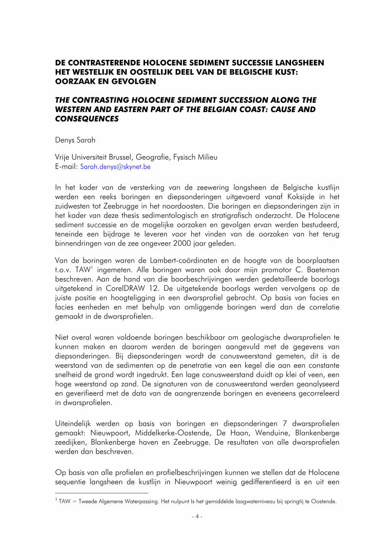
Vanaf Westende in oostelijke richting ziet de Holocene opvulling langsheen de kustlijn er anders uit (Fig. 1). De basis van de Holocene afzettingen wordt er gevormd door basisveen, dat overal bedekt is door wadklei. Op sommige plaatsen is geïntercalleerd veen teruggevonden. In het profiel van Middelkerke-Oostende is bovenop de slikke en schorre facies oppervlakteveen teruggevonden. Meer oostelijk is geen oppervlakteveen aanwezig, waarschijnlijk door de hoge ligging van de Pleistocene ondergrond. De strandafzettingen in het oosten komen voor binnen de positie van het huidig intertidaal bereik (0 – 5m TAW), wat er op wijst dat ze recent zijn, en worden dunner naar het oosten toe. De strandafzettingen worden bedekt door duinafzettingen. In de meeste profielen vinden we afzettingen van geulen of zeegaten terug. Het gaat om zand en zandig slijk van laat Holocene geulen of zeegaten, die zich diep in het veen, de wadklei en de Pleistocene ondergrond hebben ingesneden.
Middelkerke Oostende
duin facies
strand facies
getijdengeul facies zand
zand en slijk
veen
slikke en schorre facies
antropogeen beïnvloed / uitvening
Pleistocene afzettingen
gem. HWs: gemiddeld hoogwater bij springtij
gem. LWs: gemiddeld laag water bij springtij
Fig. 1. Het profiel Middelkerke-Oostende.
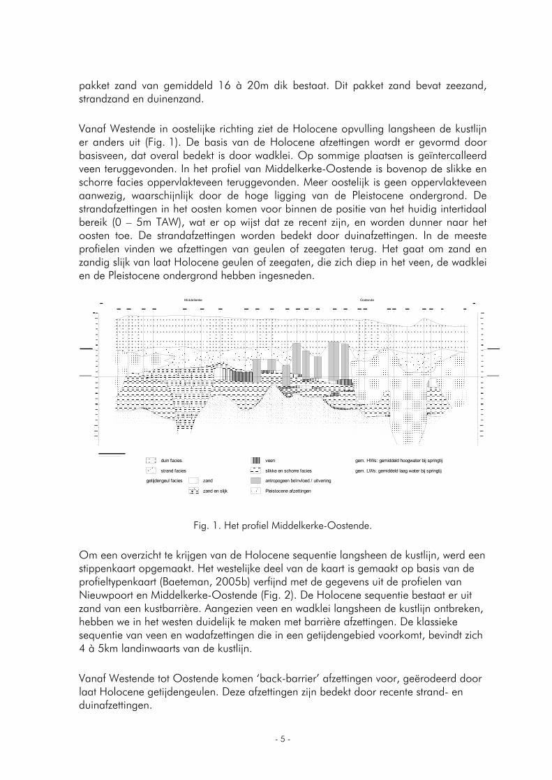
Om een overzicht te krijgen van de Holocene sequentie langsheen de kustlijn, werd een stippenkaart opgemaakt. Het westelijke deel van de kaart is gemaakt op basis van de profieltypenkaart (Baeteman, 2005b) verfijnd met de gegevens uit de profielen van Nieuwpoort en Middelkerke-Oostende (Fig. 2). De Holocene sequentie bestaat er uit zand van een kustbarrière. Aangezien veen en wadklei langsheen de kustlijn ontbreken, hebben we in het westen duidelijk te maken met barrière afzettingen. De klassieke sequentie van veen en wadafzettingen die in een getijdengebied voorkomt, bevindt zich 4 à 5km landinwaarts van de kustlijn.
Vanaf Westende tot Oostende komen ‘back-barrier’ afzettingen voor, geërodeerd door laat Holocene getijdengeulen. Deze afzettingen zijn bedekt door recente strand- en duinafzettingen.
- 6 -
Fig. 2. Stippenkaart – westelijk deel van de kustvlakte.
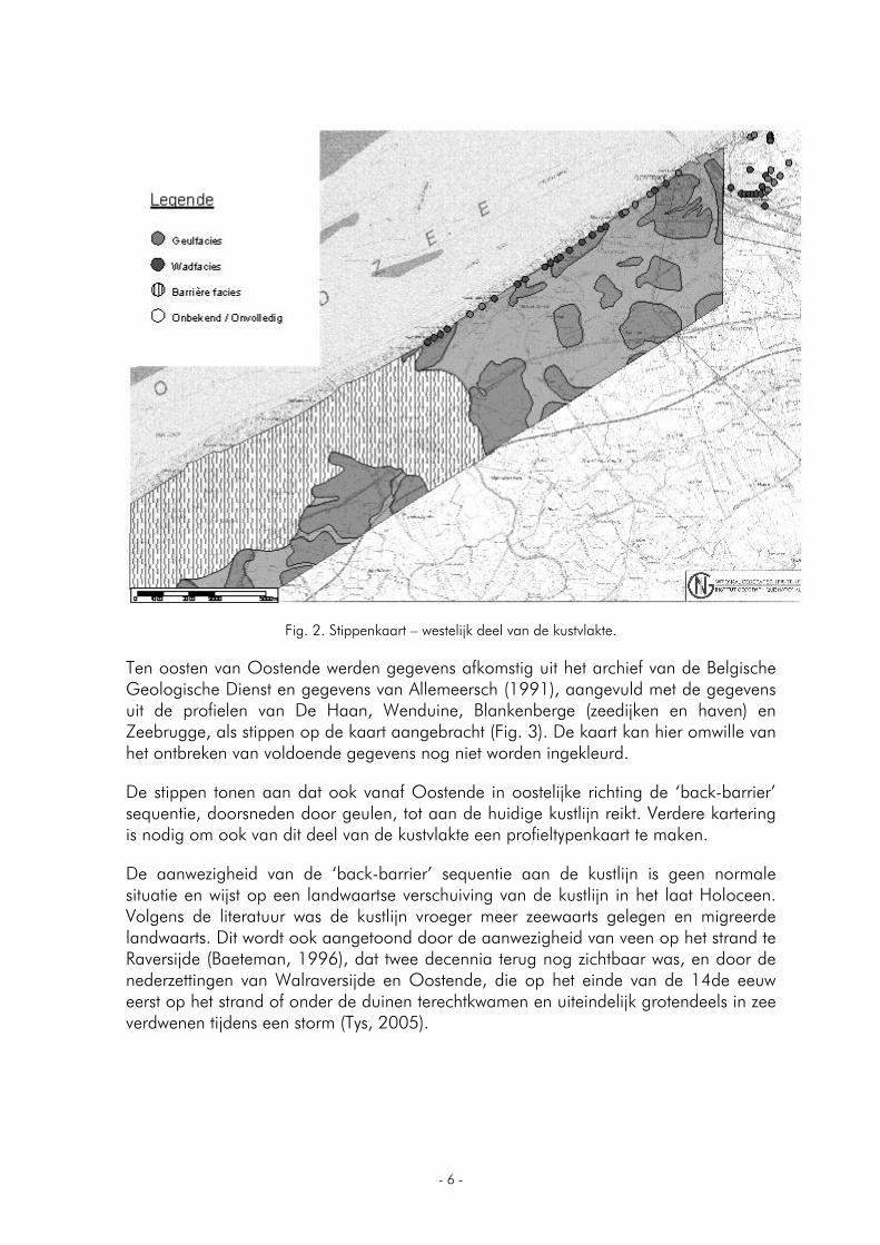
Ten oosten van Oostende werden gegevens afkomstig uit het archief van de Belgische Geologische Dienst en gegevens van Allemeersch (1991), aangevuld met de gegevens uit de profielen van De Haan, Wenduine, Blankenberge (zeedijken en haven) en Zeebrugge, als stippen op de kaart aangebracht (Fig. 3). De kaart kan hier omwille van het ontbreken van voldoende gegevens nog niet worden ingekleurd.
De stippen tonen aan dat ook vanaf Oostende in oostelijke richting de ‘back-barrier’ sequentie, doorsneden door geulen, tot aan de huidige kustlijn reikt. Verdere kartering is nodig om ook van dit deel van de kustvlakte een profieltypenkaart te maken.
De aanwezigheid van de ‘back-barrier’ sequentie aan de kustlijn is geen normale situatie en wijst op een landwaartse verschuiving van de kustlijn in het laat Holoceen. Volgens de literatuur was de kustlijn vroeger meer zeewaarts gelegen en migreerde landwaarts. Dit wordt ook aangetoond door de aanwezigheid van veen op het strand te Raversijde (Baeteman, 1996), dat twee decennia terug nog zichtbaar was, en door de nederzettingen van Walraversijde en Oostende, die op het einde van de 14de eeuw eerst op het strand of onder de duinen terechtkwamen en uiteindelijk grotendeels in zee verdwenen tijdens een storm (Tys, 2005).
- 7 -
Fig. 3. Stippenkaart – oostelijk deel van de kustvlakte.
Twee mechanismen kunnen de landwaartse migratie van kustlijn en barrière aan onze kust verklaren.
Bij het eerste mechanisme wordt bij stijgend zeeniveau het sediment van het bovenste deel van de vooroever geërodeerd en verplaatst naar het getijdengebied. Bij deze landwaartse overdracht van zand naar getijdengebied, is er een ‘rollover’ van strand en vooroeversedimenten (Roy et al., 1995).
Bij het tweede mechanisme wordt bij stijgend zeeniveau het sediment van het bovenste deel van de vooroever geërodeerd en teruggeplaatst in het onderste deel van de vooroever (Bird, 2000; Elliott, 1986).
De vorm van het strandprofiel verandert voortdurend. Deze veranderingen worden bepaald door vier factoren: de sedimenttoevoer, het golfklimaat, de substraathelling en het zeeniveau (Baeteman, 1995; Roy et al., 1995). Naast wind (duinvorming), getijdenstroming en rivieruitstroming zijn golven en door golven veroorzaakte stromingen de overheersende mechanismen voor het verplaatsen van zand op vooroevers en stranden van de open kust. De golven herwerken het sediment van de zeebodem. Het sediment wordt vervolgens door stromingen verplaatst (Bird, 2000; Elliott, 1986).
- 8 -
Verschillende oorzaken kunnen aan de basis liggen van de vooroevererosie, zoals:
toegenomen golfactiviteit, die het strand kan eroderen en zand naar de zeebodem kan meevoeren;
een verminderde toevoer van sediment, die het gevolg kan zijn van bijvoorbeeld de onderschepping van de kustdrift door bvb. golfbrekers, maar ook door uitstekende landdelen of ‘headlands’;
stormen, waardoor strandprofielen een concave vorm krijgen aangepast aan de toegenomen golfenergie. Vooral een snelle opeenvolging van een reeks stormen is bijzonder destructief omdat de opeenvolgende stormen het concave profiel verder uitbreiden en verlagen;
een verandering van de invalshoek van de golven;
een versterking van schuin invallende golven;
en verhoogde verliezen van strandsedimenten naar het droge (storm)strand of ‘backshore’ (Bird, 2000).
Een mogelijke verklaring… De top van de Pleistocene ondergrond stijgt in de profielen van ca. –9m TAW in Nieuwpoort naar –7 à –6m TAW in Oostende tot –2m TAW in Blankenberge en Zeebrugge. De lagere ligging van het westelijk deel van de kustvlakte zorgde er voor een vroegere start van de Holocene opvulling en voor een veel grotere accommodatieruimte. De snelle landwaartse uitbreiding van de sedimentaire milieus, de sterke verticale sedimentopvulling en de vooroevererosie speelden in de periode van ca. 9.500 – 9.000 cal BP tot ca. 7500 cal BP dus vooral in het westelijk deel van de kust een grote rol en zorgden er voor een meer landinwaarts gelegen kustlijn. Van bij het begin van de Holocene opvulling lag het getijdengebied in het oosten dus veel verder zeewaarts. We kunnen er dan ook van uitgaan dat in het oosten de kust verder zeewaarts lag en dat er een belangrijk ‘headland’ bestond.
Ongeveer 2400 à 2000 jaar geleden installeerde zich weer een getijdengebied in de kustvlakte. Het getij kwam binnen langs de midden Holocene geulen. Door erosie en compactie van het veen vergrootte de komberging en ontstond er nieuwe accommodatieruimte. De geulen pasten zich aan door diepe verticale erosie. Dit proces werd in het oostelijk deel van de kust nog versterkt door de veendelving van de Romeinen. Het nodige sediment voor de opvulling van de geulen en later ook voor de sedimentatie van de vlakte kwam van de vroegere Holocene opvullingen en van de erosie van getijdendelta’s en vooroever. Wat de periode van het terug binnendringen van het getijdensysteem tijdens het laat Holoceen betreft, beschikken we in de slijkgeul van Middelkerke over een radiokoolstofdatering van een concentratie van dubbelkleppige Spisula op –3,70m TAW. Deze toont aan dat de insnijding van de geul gebeurde vóór 1.888-2.176 cal BP, wat erop wijst dat het gebied rond 2.000 cal BP al sterk aan erosie onderhevig was. Een datering van een Cerastoderma op –0,17m TAW meer landinwaarts in dezelfde geul (De Hauwere, 2005), geeft aan dat deze geul vanaf 1.640-1.410 cal BP, dit is 500 tot 600 jaar later, al begon te verlanden.
- 9 -
Het ‘headland’ in het oosten kan, bij het weer binnendringen van het getij 2400 à 2000 jaar geleden, gezorgd hebben voor onderschepping van de kustdrift en een vermindering van sedimenttoevoer. Daardoor zorgde sterke vooroevererosie in het oosten voor het transport van de nodige sedimenten naar en achter de kustlijn bij de opvulling van de geulen en de vlakte. De gedateerde dubbelkleppige Spisula in de slijkgeul van Middelkerke is een bewijs van deze vooroevererosie. De Spisula is immers een typische zeeschelp en werd na de insnijding van de geul uit de zeebodem geërodeerd en in de geul afgezet. In het westen, waar door het tegenhouden van de kustdrift door het ‘headland’ veel sediment voorhanden was, speelde de vooroevererosie niet.
Door de verliezen van zand aan het getijdengebied bij de opvulling van de geulen en de ondergelopen vlakte en het niet compenseren ervan door nieuw aangevoerd sediment, was het strandprofiel verlaagd en ging de kustlijn verder achteruit. De aanwezigheid van de vele grote getijdengeulen in de ‘back-barrier’ sequentie impliceert immers dat een grote hoeveelheid zand nodig was om de geulen op te vullen. De stormen in de middeleeuwen zorgden voor een verdergaande vooroevererosie omdat het al verlaagde profiel door de stormgolven teruggesneden en steiler gemaakt werd. Hierbij werd zand vanuit het bovenste deel van de vooroever naar het onderste deel van de vooroever verplaatst.
Deze processen hebben ervoor gezorgd dat de kustlijn in het westen de laatste 2000 jaar nagenoeg ongewijzigd bleef, terwijl de vooroevererosie er in het oosten voor zorgde dat het headland in 1000 à 2000 jaar verdween en de kust naar zijn huidige rechtlijnige vorm evolueerde. Door het ontbreken van een voorraad sediment eenmaal het ‘headland’ was weggeërodeerd, duurt de vooroevererosie nog steeds voort. Zandsuppletie op het strand en vooroever is daarom noodzakelijk.
Het gevolg van deze sterkere erosie is een veel kwetsbaarder oostelijk deel van de kust. Kenmerkend voor die kwetsbaarheid zijn de smalle reepduinen en het ontbreken van droog strand bij hoog tij in bvb. Middelkerke-Oostende. Het bouwen van een vaste zeewering zorgde daarenboven voor verdergaande erosie van het strand.
Er blijven nog vragen onbeantwoord, zoals bijvoorbeeld de precieze rol van de helling van de vooroever. Vooroevererosie impliceert immers een concaaf strandprofiel en dus een steilere vooroever. Op de kaart van de bathymetrie van het Belgisch continentaal plat (Le Bot et al., 2003) zou dat zich moeten vertalen in de aanwezigheid van een steilere vooroever in het oosten. Algemeen gezien toont de kaart echter een steilere vooroever in het westen. De eerste 4 à 5 km van de vooroever tonen echter wel een minder steil bovenste deel van de vooroever ten westen van Nieuwpoort en een steilere bovenste vooroever in het oosten van de kustvlakte, vooral tussen Middelkerke en Oostende.
Met een mogelijke versnelde zeespiegelstijging als gevolg van de opwarming van de aarde in het vooruitzicht, is duurzaam kustbeheer zeer belangrijk. Bijkomend onderzoek naar de ontbrekende schakels in de processen die de kusterosie beïnvloeden, is dan ook noodzakelijk.
- 10 -
English abstract A series of drillings and cone penetration tests carried out for the sea wall fortification along the shoreline was subject to a sedimentological and stratigraphical examination, revealing a difference in sediment succession between the western and the eastern part. In the western part, the Holocene sequence along the shoreline is entirely made up of coastal barrier deposits. In the eastern direction, starting from Middelkerke, such deposits are lacking, and the Holocene sequence consists of mudflat clay and peat layers incised by late Holocene tidal channels filled with sand and/or mud. This indicates considerable coastal erosion during the late Holocene in the eastern part. The difference in sediment succession may be caused by the very different morphology of the pre-Holocene subsoil in the west and the east. A fluvial valley characterizes the west. In the east, on the other hand, the Pleistocene subsoil consists of coversands, which may have formed a headland probably extending far to the north. In the palaeovalley, a tidal flat was formed from the start of the Holocene transgression, while the eastern headland did not come under the influence of the Holocene transgression until much later. Less sediment supply by interception of the longshore drift and a lowered shoreface profile caused strong shoreface erosion from the time when, 2400 to 2000 years ago, the tidal environment re-occupied the coastal plain. This shoreface erosion most probably affected the headland in a timespan of 1000 to 2000 years.
This situation resulted in the eastern part of the coast still being subject to coastal erosion and consequently much more vulnerable than the western part.
Bibliografie
Allemeersch L. 1991. Peat in the Belgian eastern coastal plain. In: Gullentops, F. (Ed.): Wetlands in Flanders. Aardrijkskundige Mededelingen 6(1994-1995):1-54.
Baeteman C. 1995. De conflictsituatie tussen natuur en toerisme in het kustgebied. De Aardrijkskunde 5(3):5-20.
Baeteman C. 1996. Ontstaansgeschiedenis van de Belgische kustvlakte. Samenvatting. (Personal paper).
Baeteman C. 2005b. Geologische kaart van België 1/25.000. Profieltypenkaart van de Holocene Kustafzettingen. De Panne-Oostduinkerke, Nieuwpoort-Leke, Middelkerke-Oostende. Belgische Geologische Dienst Brussel.
Bird E. 2000. Coastal geomorphology: an introduction. John Wiley & Sons Ltd, Chichester, 98–107:147-160.
De Hauwere N. 2005. Ontstaan en evolutie van de Laat-Holocene getijdengeul Testerep, in het gebied tussen Nieuwpoort en Oostende (Belgische Kustvlakte). Eindverhandeling 41-42:50.
Elliott T. 1986. Siliciclastic shorelines. p.155-188. In: Reading H.G. (Ed.). Sedimentary Environments and Facies. Blackwell Scientific Publications, Oxford.
Le Bot S., V. Van Lancker, S. Deleu, M. De Batist, J.-P. Henriet. 2003. Tertiary and quaternary geology of the Belgian Continental Shelf. Science Policy Office, Brussel, België, 75p.
- 11 -
Roy P.S., P.J. Cowell, M.A. Ferland, and B.G. Thom. 1995. Wave-dominated coasts. p.121-186. In: Carter R.W.G. and C.D. Woodroffe (Eds). Coastal Evolution:late quaternary shoreline morphodynamics. Cambridge, University Press.
Tys D. 2005. Het ontstaan van de stad Oostende. In: Pieters M., L. Schietecatte and I. Zeebroek. 1995. Oostende: stadsvernieuwing en archeologie, een balans van 10 jaar archeologisch onderzoek van het Oostendse bodemarchief. Oostende, VIOE, 24.
- 12 -
Annual VLIZ North Sea Award – 2007
Each year the Flanders Marine Institute (VLIZ) awards a scientific prize to foster innovative fundamental or applied research on the structure and functioning of the North Sea ecosystem, with emphasis on coastal and estuarine aeas of the Southern Bight and the Channel. The prize is awarded to a researcher (or a research team) working and residing in a country bordering the North Sea. The prize amounts to 1000 EUR and is indivisible. It is granted to reward a recent original scientific contribution, preferably having relevance to the sustainable management of the area concerned. Studies pertaining to the biodiversity of the local ecosystem are equally welcomed. The contribution has to be of postgraduate or postdoctoral level.
The Annual VLIZ North Sea Award 2007 is awarded to:
Sofie Vandendriessche (UGent, Marine Biology Section)
for her scientific contribution entitled:
Floating seaweed as ephemeral neustonic habitat
- 13 -
FLOATING SEAWEED AS EPHEMERAL NEUSTONIC HABITAT
Vandendriessche Sofie
Ghent University, Marine Biology Section Krijgslaan 281/s8, 9000 Gent, Belgium Present address: ILVO-Fisheries, Ankerstraat 1, B-8400 Oostende, Belgium E-mail: [email protected]
The neuston can be defined as ‘those plants and animals inhabiting the surface film of the sea’. The living conditions in the upper layer of oceans and seas are considerably different from those in deeper layers. Consequently, the neustonic zone forms a restricted ecological niche inhabited by a wide range of permanent or temporary inhabitants, which are adapted to a stressful way of life in a region of a high organic matter supply. The distribution of neustonic organisms is mainly influenced by vertical migration and temporal and spatial variation. Additionally, winds, currents and the presence of floating objects can give rise to local accumulations of neustonic organisms. Of special interest is the neustonic community associated with the permanently floating seaweed Sargassum, which is abundantly found in the Sargasso Sea. Floating mats of these seaweed species significantly contribute to the primary production in the neustonic zone of the North Atlantic and consequently support a diverse community of marine organisms that use the seaweeds as food source, shelter, foraging grounds or surface for attachment.
Next to the permanently floating Sargassum, the neuston is also strongly influenced by the occurrence of smaller, and usually ephemeral floating patches composed of detached coastal seaweed fragments. Ephemeral floating seaweeds harbour a diverse fauna originating from attached seaweeds, the strandline of beaches, the surrounding and underlying water column, the seafloor or the air. These organisms colonise the seaweeds for various reasons, usually including the provision of shelter, food or attachment substrate. The association behaviour of these organisms and their use of the resources offered by floating seaweeds potentially have important ecological consequences, like the possibility of passive dispersal of associated fauna to new, distant locations by means of rafting.
The overall aim of this PhD study was to assess the ecological impact of floating seaweeds as ephemeral habitats and potential rafts in the North Sea. Because the information about the neuston and floating seaweed clumps in the North Sea was, up till now, very scarce, different aspects of raft-associated ecology were addressed.
In Chapter 2, the impact of the presence of floating seaweeds on the species composition and species richness of the neuston off the Belgian coast was assessed. Furthermore, the degree of association of the encountered species with the floating seaweed patches was quantified. The analyses were based on seaweed samples and control samples (i.e. surface water samples from a seaweed-free area) gathered in the period October 2002-April 2003. Multivariate analysis on neustonic macrofaunal abundances showed significant differences between seaweed and control samples, when considering the fraction >1mm. Differences were less conspicuous in the 0.5mm-
- 14 -
1mm fraction. Seaweed samples were characterized by the presence of seaweed fauna e.g. Acari, Idotea baltica, Gammarus sp., while control samples mainly contained Calanoida, Larvacea, Chaetognatha, and planktonic larvae of crustaceans and polychaetes. Seaweed samples (1mm fraction) harboured considerably higher diversities (x3), densities (x18) and biomasses (x49) compared to the surrounding water column (control samples). The impact of floating seaweeds on the neustonic environment was quantified by the calculation of the added values of seaweed samples considering biomass and density. These calculations resulted in mean added values of 311 ind.m-2 in density and 305mg ADW.m-2 in biomass. The association degree per species was expressed as the mean percentage of individuals found in seaweed samples in proportion to the total density and biomass of that species (seaweed samples + control samples). Thirteen species show an association percentage higher than 95%, and can therefore be considered as members of the floating seaweed fauna.
Chapters 3 and 4 focused on the structural variation within the seaweed-associated invertebrate macrofauna. The species composition of macrofauna associated with floating seaweed rafts is highly variable and influenced by many factors like spatial and temporal variation, period since detachment and probably also the seaweed species. The presence of seaweed preferences (Chapter 3) was assessed by a combination of in situ seaweed samplings and multiple-choice aquarium experiments in a controlled environment, using the seaweed-associated grazing organisms Idotea baltica and Gammarus crinicornis. Results from sampling data confirm that the seaweed composition has an effect on macrofaunal species composition and abundance: samples dominated by Sargassum muticum displayed higher densities but lower diversities compared to samples dominated by Ascophyllum nodosum and Fucus vesiculosus. Seaweed preference was also apparent from the multiple choice experiments, but did not exactly match the results of the community analysis: (1) I. baltica had high densities in seaweed samples dominated by F. vesiculosus and A. nodosum, while in the experiments this isopod was most frequently associated with Enteromorpha sp. and F. vesiculosus, and fed mostly on S. muticum, A. nodosum and Enteromorpha sp.; (2) G. crinicornis had high densities in seaweed samples dominated by F. vesiculosus, while in the experiments this amphipod was most frequently associated with S. muticum, but fed most on A. nodosum and F. vesiculosus. It is clear from the laboratory experiments that preference for habitat (shelter) and food can differ among seaweed species. However, food and habitat preferences are hard to assess because grazer preference may change if choices are increased or decreased, if different sizes of grazers are used, or if predators or other grazers are added to the experiments. Effects of seaweed composition may also be blurred due to the obligate opportunistic nature of a lot of the associated macrofaunal species.
The study described in Chapter 4 was more comprehensive and covered a larger temporal and spatial scale than in Chapter 3. The study aimed to determine what the driving forces of variation are within the invertebrate community associated with floating seaweeds, and what their relative importance is. Additionally, the temporal variation within the populations of Gammarus sp. and Idotea sp. was analysed on the levels of length and sexual maturity. The results of the multivariate analysis indicated that spatial and especially seasonal variation are important factors, next to the seaweed species composition of the clumps: the combination of the volume percentages of Fucus
- 15 -
vesiculosus and Fucus spiralis, sea surface temperature and depth resulted in the highest matching coefficient in the BIO-ENV procedure (Rho = 0.26). This coefficient, however, was still rather low, implying that other factors like seaweed age and travelling history strongly structure the assemblage. A large part of the seasonal variation was determined by the timing of the reproduction periods of the associated invertebrates. Both Gammarus sp. and Idotea sp., for example, reproduced all year round, with the highest intensity in spring. Next to predictable and measurable factors like sea surface temperature, clump volume and seaweed species composition, there are a lot of factors that are hard (e.g. clump age) or even impossible (e.g. occurrence of storms, exchanges between clumps) to quantify. Consequently, the composition and density of floating seaweed-associated macro-invertebrates can only partially be predicted or explained.
Floating seaweed is considered to be an important habitat for juvenile fishes due to the provision of food, shelter, a visual orientation point and passive transport. The importance of the presence of the highly dynamical seaweed clumps from the North Sea to juvenile neustonic fishes was investigated in Chapter 5 by analysing both neuston samples (without seaweed) and seaweed samples concerning fish community structure, and length-frequency distributions and feeding habits of five associated fish species. While the neustonic fish community was mainly seasonally structured, the seaweed-associated fish community was more complex: the response of the associated fish species to environmental variables was species specific and probably influenced by species interactions, resulting in a large multivariate distance between the samples dominated by Chelon labrosus and the samples dominated by Cyclopterus lumpus, Trachurus trachurus and Ciliata mustela. The results of the stomach analysis confirmed that C. lumpus is a weedpatch specialist that has a close spatial affinity with the seaweed and feeds intensively on the seaweed-associated invertebrate fauna. Similarly, C. mustela juveniles also fed on the seaweed fauna, but in a more opportunistic way. The shape of the size-frequency distribution suggested enhanced growth when associated with floating seaweed. Chelon labrosus and T. trachurus juveniles were generally large in seaweed samples, but large individuals were also encountered in the neuston. The proportion of associated invertebrate fauna in their diet was of minor importance, compared to the proportions in C. lumpus. Individuals of Syngnathus rostellatus mainly fed on planktonic invertebrates but had a discontinuous size-frequency distribution, suggesting that some of the syngnathids were carried with the seaweed upon detachment and stayed associated. Floating seaweeds can therefore be regarded as ephemeral habitats shared between several fish species (mainly juveniles) that use them for different reasons and with varying intensity.
Because floating seaweeds generally carry a wide variety and large densities of associated fauna, ranging from small planktonic crustaceans to juvenile fishes, the initial hypothesis of the study described in Chapter 6 therefore stated that, if present, floating seaweeds may signal the presence of abundant prey to seabirds and induce small-scale patchiness. The influence of floating seaweed patches on the distribution and behaviour of seabirds was investigated using the European Seabirds At Sea database (ESAS). The ratio of frequency of occurrence in association with floating seaweed to total frequency of occurrence differed between species and seabird groups based on their foraging strategies. The results indicated that surface feeding species that
- 16 -
make shallow dives (terns and red-breasted mergansers) benefit most from the presence of floating seaweeds and their associated macro- and ichthyofauna. Species hunting for pelagic and bottom-dwelling prey (divers, guillemots, razorbills, puffins, gannets and cormorants), and especially benthos feeders (scooters and eiders) were frequently seen in association with floating seaweeds, while opportunists and scavengers like gulls and skuas were recorded on few occasions. Finally, petrels and shearwaters (surface-seizing, pursuit-plunging, pursuit-diving) were seldomly seen in association with floating seaweeds. The most common behavioural activities of the birds associated with floating seaweed were found to be surface pecking, actively searching, and pursuit plunging.
An important consequence of association behaviour of marine organisms is the possibility of passive dispersal by means of rafting. For the study described in Chapter 7, laboratory experiments were conducted to evaluate the longevity, and consequently also the rafting capacity of the brown seaweeds Fucus vesiculosus and Ascophyllum nodosum. The seaweed degradation process and the activity of the grazer Idotea baltica were strongly influenced by temperature: only at 5°C, the seaweed growth exceeded the weight loss. At higher temperatures, seaweed fragments sank quickly (within 100 days at temperatures higher than 15°C). This process was significantly accelerated in the presence of Idotea baltica, resulting in a decrease of raft longevity of 60-70%. At a constant temperature of 15°C and in the absence of grazers, fragments of A. nodosum floated longer (mean 45 weeks) than fragments of F. vesiculosus (mean 15 weeks). The results indicate that floating seaweeds have the potential to stay afloat for a long time, but that their longevity is temperature-dependent and strongly reduced by grazing activity of associated herbivores.
The results of this PhD thesis demonstrate that the habitat formed by floating seaweeds is very complex. Although the presence of floating seaweeds in the neuston can, to a certain degree, be seasonally predicted (storms, seasonal release of fertile structures), the habitat that they form is still very patchy and unstable. Consequently, most species found in association with ephemeral floating seaweed patches are opportunistic of nature. However, some species display a higher level of adaptation to this habitat than other species, which is manifested in the reproduction by continuous brooding in Idotea baltica, the diet consisting of seaweed-associated macrofauna in Cyclopterus lumpus and the behavioural shift towards surface pecking and dipping in Sterna hirundo. The association behaviour of the encountered species and their (optimal) use of the transient resources offered by floating seaweeds potentially have important ecological consequences, like for example the passive dispersal of associated fauna to new, distant locations by means of rafting. The process of rafting strongly depends on the longevity of the seaweed raft, which is in turn significantly influenced by temperature and grazing pressure. In favourable conditions, seaweed rafts can potentially cover great distances, carrying with them rafting fauna that are able to survive a long journey in the neuston.
- 17 -
ORAL PRESENTATIONS
- 18 -
THE AIR QUALITY OVER THE NORTH SEA: HAS IT CHANGED OVER THE LAST THIRTY YEARS?
Van Grieken René
University of Antwerp, Environmental Analysis Group, Department of Chemistry, 2620 Antwerpen, Belgium E-mail: [email protected]
The presumed air quality is an important factor in the well-being of people visiting the North Sea coast. For more than three decades, we have been (partially) involved in objectively studying the atmospheric chemical composition above the North Sea and in other marine environments.
As far as atmospheric particles are concerned, the concentrations of e.g. toxic heavy metals are definitely lower at the coast, but mostly when the air masses come from the North. With easterly winds, the wind carries pollutants from all of West Europe; when the wind comes from the south, the industries of Northern France (e.g. steel industry) affect the air quality. Under the predominant Westerlies, the influence of Great Britain can be measured (e.g. from power plants, until recently), but still the levels are lower at the coast than far inland. Most of our measurements have been done by X-ray spectrometric methods, for both bulk and single particle analysis, on samples taken from airplanes and ships and at the coast. In general, the heavy metal levels have decreased significantly over the last two decades, not only for the North Sea but in general over Western Europe. Nowadays, the role of atmospheric particles (=’fijn stof’) in human health, the Global Climate Change and cultural heritage deterioration has become more important than the effect of its heavy metals on ecosystems.
Atmospheric deposition of nutrients could be an important factor in the eutrophication of the North Sea. We found that mostly gaseous ammonia, which derives from agriculture, is important here, and its levels at the Belgian coast are among the highest in the world. Also the deposition with the rain of particulate nitrate (derived from nitrogen oxides which are due to traffic) is relevant. Some decrease in these compounds has been noted, but the improvements have not been spectacular.
Iodine is ‘well known’ to be highly elevated at the coast. Some tourist brochures claim that the air over the German Wadden islands is ‘saturated’ with iodine! We have measured many different organic and inorganic, gaseous and particulate iodine species at the VLIZ station in De Haan, and indeed found the total iodine levels to be enhanced about tenfold at the coast than inland. But the daily needed intake of iodine for humans is about 100-times higher than what can be obtained by breathing a full day at the coast. Hence the physiological effect of iodine is definitely a myth, which has been around for a century or more, while no measurements had ever been done.
- 19 -
IS THE EUROPEAN EEL SLIPPING AWAY TOWARDS EXTINCTION? A REVIEW OF RESEARCH AND MANAGEMENT CHALLENGES
Maes Gregory and Filip Volckaert
Katholieke Universiteit Leuven, Laboratorium voor Diversiteit en Systematiek der Dieren, Ch. Deberiotstraat 32, B-3000 Leuven, Belgium E-mail: [email protected]
Marine organisms experience a broad range of intrinsic and extrinsic influences during their lives, which impact their population dynamics and genetic structure. Subtle interpopulation differences reflect the continuity of the marine environment, but also pose challenges to those wishing to define management units. The catadromous European eel (Anguilla anguilla) is no exception. Its spawning habitat in the Sargasso Sea and long migration across the North Atlantic qualify it as marine. However, the synergy between hydrographic variability, changing climate, and the impacts of habitat degradation and overfishing in continental waters has negatively affected stock sizes. Its protracted spawning period, variance in age-at-maturity, parental contribution and reproductive success, and the difficulty in sampling the spawning region together may mask a weak geographical genetic differentiation. Recent genetic data report evidence for spatial as well as temporal differences between populations, with the temporal heterogeneity between intra-annual recruitment and annual cohorts exceeding the spatial differences. Despite its common name of ‘fresh-water eel’, the European eel should really be managed on a North Atlantic scale. The fishery may have to be curtailed, migration routes kept open and water quality restored if it is to survive. Eel aquaculture has to focus on efficient rearing in the short term and controlled breeding in the long term. Future research on eel genetics should focus on (i) sampling and analysing spawning populations and recruitment waves to detect spatio-temporally discrete groups, and establishing a biological baseline from pre-decline historical collections for critical long-term monitoring and modelling of its genetic composition; (ii) the analysis of adaptive genetic polymorphism (genes under selection) to detect adaptive divergence between populations, perhaps requiring separate management strategies; and (iii) improving artificial reproduction to protect natural stocks from heavy exploitation, especially now the species has been categorized as endangered (Maes and Volckaert, 2007).
References
Maes G.E. and F.A.M. Volckaert. 2007. Challenges for genetic research in European eel management. ICES J Mar. Sci. 64:1463–1471.
- 20 -
WAVES IN THE NORTH SEA: POWERING OUR FUTURE?
De Backer Griet , Charlotte Beels and Julien De Rouck
Universiteit Gent, Vakgroep Civiele Techniek, Afdeling weg- en waterbouwkunde, Technologiepark Zwijnaarde 904, B-9052 Zwijnaarde, Belgium E-mail: [email protected]
Ocean waves contain huge amounts of energy which almost haven’t been exploited up to now. Along the West European coastline the wave power resource is varying between 30 and 70kW/m crest length (Thorpe, 1999). These huge amounts of wave power increase the potential energy capture on the one hand but hamper installation on the other hand. Furthermore the survivability of conversion systems could be in danger in these severe wave conditions.
The wave climate in the North Sea is less aggressive due to the sheltering effect of Great Britain. The wave power resource and potential areas for installation of a farm of Wave Energy Converters (WECs) in the North Sea will be discussed during the presentation.
Wave energy is a renewable energy type that is becoming more and more important. Many conversion principles have been invented and are currently being developed, tested and improved. Research on power optimization, structural design, etc. is going on while interest of private investors is increasing.
Although many concepts have been invented, only a limited number of systems have already been built in prototype size and have experienced real sea trials. Even fewer have reached a commercial stage. Among them is the Pelamis the converter which is probably most ahead of the others. This system, sometimes called ‘sea snake’ consists of four hinging cylinders that produce electricity via a hydraulic intermediate stage. The Portuguese consortium Enersis will shortly install three units of 750kW each in front of the Portuguese coast. Some other systems that have experienced sea trials – mostly at scaled size – are Wave Dragon, FO³, Wave Star, AquaBuOY, OPT Power Buoy, Pico power plant, Limpet device,… Some of these systems will be treated more in detail during the presentation.
References
Thorpe Tom. 1999. An overview of wave energy technologies: status, performance and costs. Wave power: moving towards commercial viability, 30 November 1999, Broadway House, Westminster, Londen.
Website Pelamis: http://www.pelamiswave.com.
- 21 -
MARINE SCIENCE AND EDUCATION IN ONE WORD: ‘PLANEETZEE.ORG’
Seys Jan and Evy Copejans
Vlaams Instituut voor de Zee, Flanders Marine Institute, VLIZ – InnovOcean site, Wandelaarkaai 7, B-8400 Oostende, Belgium E-mail: [email protected]
It is a major challenge to bring science and technology to the public at large and more particular to young people. This is even more true for marine sciences, due to the very nature of the study field and the fact that the underwater world is difficult to experience and communicate. Therefore it is not surprising that in Europe there are only few examples of marine educational projects that try to go beyond the ‘observe and describe’ approach.
In 2004 SHE Consultancy, the Flanders Marine Institute VLIZ and DAB Vloot developed a first Belgian e-learning programme dedicated to oceans and seas, with the support of the Flemish government (‘Action plan Science Communication’). This programme was called ‘Expedition Zeeleeuw’ (www.expeditiezeeleeuw.be), ran from 2005 till 2007 and challenged some 3000 Flemish students of 16-18 years old all over Flanders to find creative solutions for 10 major marine issues at the Belgian coast. The class that could convince the jury to have discovered the most creative and intelligent solutions, won a one-week scientific expedition at sea on board the vessel Zeeleeuw.
As a successor to ‘Expedition Zeeleeuw’, a new e-learning project on marine science has been developed: ‘Planeet Zee’ (or ‘Planet Ocean’: www.planeetzee.org; info via [email protected]). The same partners endeavoured to use the experience gained within Expedition Zeeleeuw and to upgrade where possible and desirable. The new project has become a virtual sailing trip around the Atlantic Ocean, linked to the story of two youngsters ‘borrowing’ the yacht of their father and getting into trouble on the open ocean. Along their journey they face a total of 21 problems (out of food, drinking water or fuel, fear for whales, Bermuda triangle, tsunami’s etc.), introduced by a short movie clip. They ask for radio help and – what a surprise! – get interesting answers from the Zeeleeuw research vessel and its 21 marine scientists on board. Every answer is found on the website and consists of an animated lecture with pictures, movies, diagrams etc., followed by exercises, hints for field excursions, laboratory experiments, interactive games, etc.
The seven major themes from this project have been isolated from the ESF-Marine Board position paper on future marine research ‘Navigating the Future III’: climate-ocean interactions, biodiversity, living and non-living resources, oceans and society, physical oceanography, harbours and shipping. The 21 topics are spread over the coastal areas, shallow seas and deep ocean habitats of the North Atlantic, and make use of the best possible scientific know-how in Belgium and abroad. By providing so many topics and more than 80 practical exercises, ‘Planeet Zee’ hopes to present the ideal format to be used by teachers in biology, physics, chemistry and geography (all levels for students as from 16 years). For marine scientists, it is probably the best way to have their know-how translated to a young public within a school context.
- 22 -
MAPPING THE SEABED OF THE BELGIAN PART OF THE NORTH SEA TO ASSIST IN A SCIENCE-BASED APPROACH TO MANAGEMENT
Du Four Isabelle, Els Verfaillie and Vera Van Lancker
Ghent University, Renard Centre of Marine Geology (RCMG), Krijgslaan 281 – S8, 9000 Gent, Belgium E-mail: [email protected]
Knowledge of the spatial distribution of sediments, the impact of human activities on the seabed and the natural evolution of the seabed is important to assist in a more sustainable management of the Belgian Part of the North Sea (BPNS). Sediments are an essential part of any aquatic system and are the key for a better understanding of the marine ecosystem; moreover, they are a valuable socio-economic resource for construction material and beach nourishment; therefore, they are extracted increasingly. Research on sediment nature and processes are important also for the optimisation of dredging and dumping activities, the implantation of windmill farms, seabed constructions, cables and pipelines, the designation of marine nature reserves and, generally, any spatial planning initiative.
Related to the BPNS research, the Renard Centre of Marine Geology (RCMG) of Ghent University has been/is actively involved in various inter- and multidisciplinary projects. Throughout these projects, a research strategy is followed that balances between process/modelling studies, and the optimisation of the use of various acoustical and sampling techniques.
Results from three research projects, related to the mapping of the seabed of the BPNS, will be presented.
During the Marebasse project (Belspo, SPSDII; http://users.ugent.be/~vvlancke/ Marebasse/), significant new sampling and acoustical data was acquired in typically mud-, sand- and gravel-dominated areas (Van Lancker et al., 2007). On the scale of the BPNS, new thematic maps, related to the bathymetry, sedimentology and morphology, were produced. Automated modelling of these physical data layers, based on advanced geostatistical methods, have resulted in physical habitat maps with ecological relevance. On a smaller scale, impact studies of aggregate extraction and dumping of dredged material were performed on selected sites, integrating results from geo-acoustical surveys and terrain verifications. Results have shown that, on a short- to medium-term, the effects seem relatively localised. All results are integrated into a Geographical Information System GIS@SEA (The physical seabed GIS to support Studies and Environmental Applications).
As the Marebasse project focussed on the spatial variability of the seabed nature and the short- to medium-term impact of human activities, knowledge of the natural evolution of the seabed, its response to sea-level rise and the long-term anthropogenic impact remains poor. These issues are investigated now in the QUEST4D project (Belspo, SSD; http://www.vliz.be/projects/Quest4D/). Through quantification of erosion/sedimentation patterns, the natural evolution will be compared against the impact of human activities. Results will be presented of the area north of the Vlakte van
- 23 -
de Raan, including the dumping ground Br&W S1. Acoustical maps of the seabed reveal different sedimentation and erosion patterns, originating from natural processes and human-induced activities (Van Lancker et al., 2008).
The socio-economic importance of seabed resources is further dealt with in the RESOURCE-3D project (Belspo Targeted Action), in which a 3D reconstruction of the internal structure of sandbanks is aimed at. A case study on the Kwinte Bank will be presented.
References
Van Lancker V., I. Du Four, E. Verfaillie, S. Deleu, K. Schelfaut, M. Fettweis, D. Van den Eynde, F. Francken, J. Monbaliu, A. Giardino, J. Portilla, J. Lanckneus, G. Moerkerke and S. Degraer. 2007. Management, research and budgetting of aggregates in shelf seas related to end-users (Marebasse). Final Scientific Report. Belgian Science Policy. 125p.
Van Lancker V., I. Du Four, M. Fettweis, D. Van den Eynde, M. Devolder, F. Francken, J. Monbaliu, T. Verwaest, J. Janssens, S. Degraer, J.-S. Houziaux, H. Vandenberghe and A. Goffin. 2008. QUantification of Erosion/Sedimentation patterns to Trace the natural versus anthropogenic sediment dynamics (QUEST4D). Annual Scientific Report Year 1. Science for Sustainable Development. Brussels: Belgian Science Policy. 27p.
- 24 -
THE NORTH SEA, PAST AND PRESENT: SHIFTING BASELINES AND HUMAN USES
Lindeboom Han
Wageningen IMARES - Institute for Marine Resources and Ecosystem Studies, Haringkade 1, 1976 CP IJmuiden, The Netherlands E-mail: han.lindeboom @wur.nl
A clear change of species distribution in the North Sea can be deduced when comparing the maps from Olsen’s Piscatorial Atlas published in 1883 with present fish surveys. Many species have disappeared from large areas. For example, 20,000km² of oyster beds disappeared, most likely due to a combination of overfishing, possibly climate change and diseases. This had large consequences for the local biodiversity. Even in Olsen’s time, there was concern about the fishing pressure.
And human pressure upon this vulnerable ecosystem keeps increasing. Apart from traditional uses such as fisheries, gas, oil and sand extraction and shipping, new functions such as wind energy, offshore protection and the possible construction of new islands are using more and more space.
The first offshore wind park is now operational in The Netherlands and a large research program is being conducted concerning the possible effects of this type of park upon benthic fauna, fish, birds and sea mammals. Initial results indicate that some birds profit from the park while others avoid it. At the same time new parks are being planned, and if this continues the Dutch section of the North Sea may be strewn with small-sized wind parks in tens years time. But is this wise? Both for ecological and safety reasons it seems much better to build a few large parks instead of many small ones. And this is just one of the problems with spatial planning in the sea.
For centuries, the Dutch part of the North Sea has been heavily fished. Since the 1960s a large beam trawl fleet has been harvesting sole and plaice using 4 and 12m beam trawls with tickler chains that frequently plough or rake most of the sea floor in this area. The direct effects of this type of fisheries are well known. Large amounts of unwanted by-catch are discarded and die. The long-term effects include destruction of habitats and shifts in biodiversity, species composition or age structure of benthic invertebrate and fish communities. Recent studies show clear differences between the fished and non-fished areas.
The EU has asked the member states to create Marine Protected Areas (MPAs) to stop further deterioration of the marine realm. Plans for their designation are under development.
In the near future, sustainability targets will have to be defined for these areas. However, the development of the marine ecosystem is the result of a very complex interplay between natural and human induced causes, the final result being an integrated summation of the effects of manageable and non-manageable factors. When managing the development of MPAs we have to take into account effects of climate change, pollution, introduced species and other drivers. In the presentation, the possible establishment of MPAs in the southern part of the North Sea and its values for spatial planning and conservation of marine biodiversity will be discussed.
- 25 -
POSTER & DEMO PRESENTATIONS
- 26 -
DISCARDING IN BEAM TRAWL FISHERIES: QUANTIFICATION AND REDUCTION (PRELIMINARY RESULTS)
Anseeuw Dieter, Kelle Moreau, Sofie Vandemaele and Sofie Vandendriessche
Insituut voor Landbouw en Visserij Onderzoek Ankerstraat 1, B-8400 Oostende, Belgium E-mail: [email protected]
Since 2002, the European Union’s Data Collection Regulation requires EU member states to collect discard data on commercial fishing vessels. In response, discard sampling in the Belgian beam trawl fishery is carried out by sea-going observers since 2003, but is mainly focused on commercially valuable fishes. From 2007, the research project TOETS prepares the extension of the data collection programme towards commercially unimportant fish species and non-fish organisms.
Four sampling trips were undertaken on Belgian beam trawlers in the TOETS framework so far (October 2007-January 2008). Both volume and composition of the discards were studied for different parts of the North Sea and the English Channel. In two trips, fishing gear type (among the various factors influencing the amount of discarded organisms in a catch) was manipulated on one side of the fishing vessel to evaluate potential reductions in discard yields through technical adaptations. The adaptations involved the use of square mesh codends and the incorporation of a benthos release panel.
The variability in volume and composition of discards (primarily changing with fishing vessel, geographic region and period of the year), and in commercial yield-to-discard ratios is illustrated. Furthermore, we compared catches of standard and adapted beam trawl nets to evaluate the alternatives’ potentials to reduce fish and non-fish discards while commercial fish yield is retained (preliminary results).
- 27 -
Aphia FOR A WORLD REGISTER OF MARINE SPECIES (WoRMS)
Appeltans Ward1, Mark J. Costello2, Bart Vanhoorne1, Wim Decock1, Leen Vandepitte1, Francisco Hernandez1, Jan Mees1 and Edward Vanden Berghe3
1 Flanders Marine Institute, Vlaams Instituut voor de Zee, VLIZ – InnovOcean site, Wandelaarkaai 7, B-8400 Oostende, Belgium E-mail: [email protected]
2 University of Auckland, Leigh Marine Laboratory, Box 349, Warkworth, New Zealand 3 Rutgers University, Institute of Marine and Coastal Sciences, 71 Dudley Road, New Brunswick,
NJ 08901, USA
An authoritative and global register of all marine species is urgently needed to facilitate biological data management and exchange, the integration of ecological and biodiversity data with non-biological ocean data, and to assist taxonomists in describing new species, revisions and correcting past nomenclatural confusion. The exercise of producing this list has added benefits in fostering collaboration between experts at a global scale and maintaining taxonomic expertise. Easy access to the register will allow local ecologists and biologists to use correct taxonomic names, and will encourage addition of overlooked species to the list. This will in turn stimulate a.o. biodiversity science and biogeographic and evolutionary research. This ‘World Register of Marine Species’(WoRMS) is the logical next step for ocean biodiversity informatics (OBI) to become an everyday and essential supporting infrastructure for the marine sciences, monitoring and environmental management. WoRMS is a standards based, quality controlled, expert validated, open-access infrastructure for research, education, and data and resource management. It builds on experience in developing the European Register of Marine Species and the Ocean Biogeographic Information System, and will collaborate with and contribute to the GBIF’s ECAT and planned Global Names Architecture, Species 2000, the Catalogue of Life, the Ocean Biogeographic Information System, the Encyclopaedia of Life, SeaLifeBase, IOC’s International Oceanographic Data and Information Exchange, and related initiatives. The Aphia database, developed and maintained by the Flanders Marine Institute (VLIZ), serves as the IT platform for WoRMS. Currently, well over 100 world leading taxonomists are contributing towards this World Register of Marine Species. We will demonstrate the WoRMS webportal and all its functionalities, such as the web-based services and the online edit tool for the taxonomic experts. For further details see http://www.marinespecies.org.
- 28 -
CLIMATE RECONSTRUCTION BASED ON ARCHAEOLOGICAL BIVALVE SHELLS
Bauwens Maite1,2, Fabrice Servaes1, Veerle Beelaerts2, Céline Poulain3, Philippe Dubois4, Johan Schoukens2 and Frank Dehairs1
1 Vrije Universiteit Brussel, Department of Analytical and Environmental Chemistry, Pleinlaan 2, 1050 Brussel, Belgium E-mail: [email protected]
2 Vrije Universiteit Brussel, Department of Fundamental Electricity and Instrumentation, Pleinlaan 2, 1050 Brussel, Belgium
3 Institut Universitaire Européen de la Mer, Laboratoire des Sciences de l'Environnement Marin, Place Nicolas Copernic, Technopôle Brest Iroise, 29280 Plouzané, France
4 Université Libre de Bruxelles, Laboratoire de Biologie Marine, Université avenue F.D. Roosevelt, B-1050 Brussel, Belgium
Several years of biogeochemical research on bivalve shells yielded in clear proxy-records carrying potential for reconstruction of paleoseasonal trends in coastal environments. However, the interpretation of the proxy signals is still often problematic. Proxy concentrations can be influenced by several environmental parameters and by physiological processes. With more complex models these problems can be tackled. Two strategies are followed; (1) a statistical black-box model is being developed in parallel with (2) a physiological white-box model.
The statistical black-box model can be described as a non-linear multi-proxy model. It is based on chemical measurements in modern bivalve shells and consists of the construction of a curve in a multi-dimensional space. The model describes the variations in the chemical signature of the shell during a full year cycle. The shortest distance from any other data point (e.g. a fossil shell) to the model will give a time point estimation in the annual cycle, which can further be linked to environmental parameters. At present our model approach achieves quite accurate SST reconstructions.
A white box model is crucial for understanding the physiological processes and for an unambiguous interpretation of the proxy records. We investigated, in a first phase, in situ the influences of environmental parameters and physiology on the incorporation of proxies in Mytilus edulis at a well documented wave breaker site. In a second phase, in vitro culturing experiments under controlled laboratory conditions were carried out. Experiments were carried out at 8°C and 16°C and at salinities of 18‰ and 28‰. During these experiments mussels were fed under high and low supply regimes. By combining these in situ and in vitro approaches a white box multi-proxy model is generated for the reconstruction of SST and SSS.
- 29 -
THE COAST, A MATTER OF BALANCE: AN INSIDE VIEW ON THE COORDINATION CENTRE ON INTEGRATED COASTAL ZONE MANAGEMENT
Belpaeme Kathy, Hannelore Maelfait and Sylvia Theunynck
Coordinatiepunt Duurzaam Kustbeheer Wandelaarkaai 7, B-8400 Oostende, Belgium E-mail: [email protected]
Our mission Our mission is to stimulate and promote the sustainable and integrated management of the Belgian coastal zone. The Coordination Centre is the prime point of contact for everyone in the coastal zone that is involved in cross-sector issues.
Together with our partners, the Province of West Flanders, the Flemish authorities, (1) the Department of Mobility and Public Works, Agency for Maritime and Coastal Services, Coastal Division; (2) the Department of the Environment, Nature and Energy, Agency for Nature and Forests and Flanders Marine Institute (VLIZ) we try to achieve this goal.
What can you expect from us? We communicate on and enhance awareness of integrated coastal zone management, by making publications, articles, websites such as the coast, a matter of balance, the coastal atlas, gulls at the coast… We organize seminars, workshops and symposia.
We act as the point of contact for integrated coastal zone management and give information to interested persons in Belgium and abroad.
We offer a platform for consultation on integrated coastal zone management
We assure the follow-up of the sustainability indicators in the coastal zone. By means of a website and the publication ‘the Coastal Compass’ we deliver concrete data, especially based on the coastal zone.
We cooperate in the realization of the European Recommendation regarding the implementation of an integrated coastal zone management in Europe
What do we do? Three examples:
The Coastal Atlas: a well illustrated atlas with beautiful pictures and handy maps. Also online available with the possibility to download, data, gis maps and pdf-files. Check www.kustatlas.be
The awards for sustainable coast project: Hereby we want to support original projects which contribute to a sustainable coast. Check www.dekustkijktverder.be for more information on the nominated projects.
- 30 -
The sustainability indicators for the coast: To pursue effective policies for the coast, a wide variety of high-quality information and data is needed. Therefore the Coordination centre developed and implemented a set of indicators for the coast. We bring the indicators actively and repeatedly to the attention of policy makers and potential end users. To this end, an interactive Internet site (www.kustbeheer.be/indicatoren) and a recurrent publication: ‘The Coastal Compass’, are developed.
If we can help you… contact us!
- 31 -
THE SCHELDT INFORMATIONCENTER: AN INFORMATION PLATFORM FOR THE ESTUARY OF THE RIVER SCHELDT
Beyst Bregje and Melissa Prosec
Schelde InformatieCentrum p/a VLIZ – InnovOcean site, Wandelaarkaai 7, B-8400 Oostende, Belgium E-mail: [email protected]
The Scheldt InformationCenter acts as an information platform for the estuary of the River Scheldt. This center is active in both Flanders and The Netherlands. Its area of interest concerns the tide-related part of the River Scheldt, i.e. from Ghent (B) to the mouth in Vlissingen (NL). The main task of the Scheldt InformationCenter is putting information about the estuary area at the disposal of everybody interested in the subject. Additionally, the institute acts as a contact point. The Scheldt InformationCenter contributes also in popularising less accessible reports and publications and has therefore an interface function between the public authorities, the scientific community and the public at large. Coordinating Scheldt-related projects is another task of the institute. In all activities, the different functions of the estuary, safety, policy and management are central issues. By informing everybody about the River Scheldt, the institute hopes to enlarge the involvement and public awareness of this estuary, a river so important for Sealand (NL) as well as Flanders (B).
Het Schelde InformatieCentrum is een grensoverschrijdende organisatie die, vanuit een nauwe samenwerking tussen Vlaanderen en Nederland, een informatieplatform is voor het Schelde-estuarium. Het centrum informeert en documenteert over het getijgebonden deel van de Schelderivier tussen Gent en Vlissingen. Het hoofddoel van het Schelde InformatieCentrum is het versterken van de kennis over en het inzicht in het Schelde-estuarium. Het centrum stelt hiervoor informatie ter beschikking voor iedereen, die persoonlijk of op professioneel vlak, geïnteresseerd is in het onderwerp. Het profileert zich zodoende als een aanspreekpunt voor het Schelde-estuarium. Dit heeft zowel betrekking op de natuur, economie, recreatie, veiligheid als het beheer en beleid aangaande de Schelde. Door moeilijk toegankelijke rapporten en publicaties te ‘vertalen’, kan het SIC de tussenstap zijn bij communicatie van de overheid en wetenschappelijke instellingen naar het ‘grote publiek’. Om dit doel te bereiken coördineert het SIC verscheidene projecten. Door een grotere betrokkenheid van de bevolking met het estuarium te bevorderen hopen wij bij te dragen tot een duurzame ontwikkeling van het Schelde-estuarium.
- 32 -
FISHBASE: THE ON-LINE ANSWER TO ICHTHYOLOGICAL ISSUES
Boden Gert, Tobias Musschoot and Jos Snoeks
Royal Museum for Central Africa, Department of Zoology, Ichthyology Leuvensesteenweg 13, B-3080 Tervuren, Belgium E-mail: [email protected]
FishBase was initiated by Daniel Pauly and Rainer Froese as an electronic fact sheets database for the economically most important fish species. From 1987 onwards FishBase was developed at the WorldFish Center (former ICLARM), and subsequently financed by the European Commission between 1989 and 2000. Since 2001, FishBase is supported by a consortium, including the WorldFish Center (Malaysia), FAO (Italy), The Royal Museum for Central Africa (Belgium), the Natural History Museums of Paris (France) and Stockholm (Sweden), the Universities of Kiel (Germany), British Columbia (Canada) and Thessaloniki (Greece), and the Chinese Academy of Fishery Sciences (China). At present FishBase is the largest on-line encyclopaedia on fishes, with about 20 – 25 million hits per month.
Information on more than 30,000 fish species is available through the FishBase portal (www.fishbase.org) or one of its 6 mirror-sites, including data on the taxonomic position, distribution, morphology and ecology, as well as numerous aspects of aquaculture and fisheries biology. Information is based on scientific publications or provided by experts. Many deep links are provided to other relevant websites such as those of the IUCN (conservation) and GenBank (genetics). The Royal Museum for Central Africa is responsible for the validation and updating of the information on all African fresh- and brackish water fishes and developed in 2007 a portal for the African inland fishes (www.fishbaseforafrica.org).
FishBase contains a lot of applications for fish and fisheries scientists, such as tools for fish identification, biogeographical modelling, construction and analysis of trophic pyramids, analysis of fishery and aquaculture statistics, diagnosis of fish diseases, etc. Some of these have already proved their importance to support concepts like ‘fishing down food webs’ (Pauly et al., 1998).
References
Pauly D., V. Christensen, J. Dalsgaard, R. Froese and F. Torres, Jr. 1998. Fishing down marine food webs. Science 279(5352):860-863.
- 33 -
THE ROLE OF MACROFAUNA IN THE FUNCTIONING OF A SEA FLOOR: IS THERE ANY SEASONAL, DENSITY OR FUNCTIONAL IDENTITY EFFECT?
Braeckman UIrike1, Provoost Pieter2, Britta Gribsholt3, Jack Middelburg2, Karline Soetaert2, Magda Vincx1 and Jan Vanaverbeke1
1 Universiteit Gent, Vakgroep Biologie, Afdeling Mariene Biologie Krijgslaan 281 S8, B-9000 Gent, Belgium E-mail: [email protected]
2 NIOO-CEME Korringaweg 7, Yerseke Mariene Microbiologie, Postbus 140, 4400 AC Yerseke, the Netherlands
3 Department of Biology, Marine Biological Laboratory Strandpromenaden 5, DK-3000 Helsingør, Denmark
Macrobenthos influences rates and intensities of benthic processes. The way in which these processes are affected depends on their densities and functional characteristics in terms of sediment reworking (bioturbation and bio-irrigation). This study focuses on the importance of three different functional groups (FG) of macrobenthos in the ecosystem processes of the Western Coastal Banks area (Belgian Part of the North Sea). Macrobenthic activity depends on temperature and food availability. Therefore two lab experiments were performed: one before sedimentation of the phytoplankton bloom (spring: low food availability and temperature) and one when organic matter had been settled on the sea bottom (late summer: high food availability and higher temperatures). Single – species treatments of key-species belonging to three different functional groups were added to microcosms at three density levels (average natural, lower and very low) to account for possible density declines. These species are the bivalve Abra alba (FG: biodiffuser), the tube-building polychaete Lanice conchilega (FG: piston-pumper) and the predatory polychaete Nephthys sp. (FG: regenerator/gallery-diffuser).
In both winter - and summertime, L. conchilega had a more pronounced influence on oxygen consumption and release of nutrients out of the sediment than A. alba and Nephtys sp.. Abra alba appeared to be a more effective sediment reworker than Nephtys sp. in both seasons. In addition, ecosystem functioning (as oxygen consumption by the sediment community and bioturbation) seems to be related to animal densities. As such, a decline of densities (due to anthropogenic or natural disturbances) most probably will decrease the rates of ecosystem functioning in the Western Coastal Banks area.
- 34 -
FLANDERS BUILDS NEW RESEARCH VESSEL ‘SIMON STEVIN’
Cattrijsse André and Jan Mees
Vlaams Instituut voor de Zee, Flanders Marine Institute, VLIZ – InnovOcean site, Wandelaarkaai 7, B-8400 Oostende, Belgium E-mail: [email protected]
On 10 December 2007 Minister-President Kris Peeters and Minister Patricia Ceysens disclosed the plans of the Flemish Government to build a new research vessel to replace the current vessel RV Zeeleeuw. The Flanders Marine Institute (VLIZ) will be responsible for the scientific programme and management of the research equipment. DAB Vloot (MDK) will ensure the good operation of the new coastal vessel. The ship was named ‘Simon Stevin’ after a Flemish intellectual jack-of-all-trades (°1548, Bruges) with numerous maritime and hydraulic achievements.
By constructing this new research vessel Flanders not only undertakes to provide a successor for the oceanographic vessel RV Zeeleeuw but also wants to stress that it continues to invest in scientific and technological innovations as an engine for a sustainable society.
Since 2001 marine researchers have been able to board the Zeeleeuw to carry out scientific samplings in the North Sea and the Scheldt Estuary. Constructed in 1977, the Zeeleeuw was converted from a pilot vessel into a research vessel for this purpose in 2000. In recent years it has become clear how this investment has resulted in better and more multidisciplinary marine scientific top research in our region and to training opportunities for marine scientists.
A recent poll and feasibility study among the over 500 marine scientists in Flanders confirmed that there is a great need for logistic support of their research. Within this context priority needs to be given to a modern and well-equipped vessel with a shallow draught and swift access to the shallow coastal waters of the southern bight of the North Sea and the adjacent river estuaries.
By building this new vessel Minister Patricia Ceysens wants to continue along the path of innovation in the field of research and technology. The new ship will meet the established need to spend time on board within the scope of research of monitoring and will keep Flemish scientists in the European lead. The new research vessel will furthermore be able to actively contribute to international marine management obligations and to substantiating the Flemish policy on fishing and port accessibility. The ship will also be used for training and educational purposes and as a test platform for new maritime technologies.
In its capacity as multifunctional shipowner on behalf of the Flemish Government the DAB Vloot (Agency for Maritime and Coastal Services) will use its nautical and technical expertise to ensure good operation of the vessel. The Flanders Marine Institute (VLIZ) will be responsible for the scientific programme of the voyages and the management of the research equipment. As a result of this major step in the support of marine scientific
- 35 -
research the VLIZ will be able to fulfil its role as a facilitator of marine scientific knowledge development and as a marine focal point for the international community even better in the future.
Minister Ceysens also announced the purchase of additional land-based facilities. These facilities are located within walking distance of the VLIZ and are part of the InnovOcean site, the central site for oceanographic initiatives on the east bank in Ostend. Minister-President Peeters has undertaken to ensure that the vessel is manned and maintained by DAB Vloot and leaves port daily for research purposes.
Further information on http://www.vliz.be/EN/INTRO&id=269
- 36 -
THE USE OF INTEGRATIVE PASSIVE SAMPLERS AS A SOURCE OF CONTAMINANT MIXTURES IN ECOTOXICOLOGICAL LABORATORY EXPERIMENTS
Claessens Michiel1, Els Monteyne2, Patrick Roose2 and Colin Janssen1
1 Ghent University, Department of Applied Ecology and Environmental Biology, Laboratory of Environmental Toxicology and Aquatic Ecology, Jozef Plateaustraat 22, B-9000 Gent, Belgium E-mail: [email protected]
2 Management Unit of the North Sea Mathematical Models (MUMM), 2e en 23e
Linieregimentsplein, B-8400 Oostende, Belgium
The INRAM project aims to introduce a new application of passive sampling devices in ecological toxicity testing. Conventional (laboratory) ecotoxicity studies are mostly performed by exposing test organisms to various (high) concentrations of a single test compound. This clearly does not reflect in situ conditions: i.e. exposure to mixtures of low levels of various micro-pollutants. In order to expose organisms to environmentally realistic contaminant mixtures, this study explored a novel use of integrative passive samplers. Firstly, the dynamics of the contaminant release from the samplers was studied in the presence of organic material, i.e. algal cells. This study showed that the samplers released the compounds into the test medium as expected. Constant concentrations were achieved in the test medium, but the target concentrations (based on the amount of compound spiked on the samplers) were not reached. Additional experiments will be carried out in order to improve the dynamics of contaminant release. Secondly, samplers were used to collect micro-pollutants from three Belgian coastal harbours and were used ‘inversely’ as a contaminant mixture source in laboratory toxicity assays with Crassostrea gigas larvae. Significant differences in normal development of the oyster larvae were observed between the three harbours. Within each harbour a pollution gradient was apparent. These results show that the targeted application of passive samplers is feasible. As these passive samplers also allow to determine the aqueous concentrations of otherwise (nearly) undetectable trace compounds, they could be a powerful new tool in environmental toxicology.
- 37 -
INRAM – INTEGRATED RISK ASSESSMENT AND MONITORING OF MICROPOLLUTANTS IN THE BELGIAN COASTAL ZONE
Claessens Michiel1, Karen Rappé2, Els Monteyne3, Klaas Wille4, Herlinde Noppe4, Magda Vincx2, Hubert De Brabander4, Patrick Roose3, Jan Mees5 and Colin Janssen1
1 Ghent University, Department of Applied Ecology and Environmental Biology, Laboratory of Environmental Toxicology and Aquatic Ecology, Jozef Plateaustraat 22, B-9000 Gent, Belgium E-mail: [email protected]
2 Ghent University, Biology Department, Marine Biology Section, Campus De Sterre, Krijgslaan 281/S8, B-9000 Gent, Belgium
3 Management Unit of the North Sea Mathematical Models (MUMM), 2e en 23e Linieregimentsplein, B-8400 Oostende, Belgium
4 Ghent University, Department of Veterinary Public Health and Food Safety, Laboratory of Chemical Analysis, Salisburylaan 133, B-9820 Merelbeke, Belgium
5 Flanders Marine Institute (VLIZ), Wandelaarkaai 7, B-8400 Oostende, Belgium
The INRAM project is an integrated project funded by the Belgian Science Policy to develop practical techniques and procedures to detect the risks of micropollutants occurring in the Belgian coastal zone. The underlying objective of the INRAM project is to develop a novel, multidisciplinary methodology – based on a suite of chemical, biological and ecological measurements – to evaluate the health of marine ecosystems.
To this end, an extended list of micropollutants will be analyzed in water, sediment and suspended solids of 18 sampling stations in the Belgian coastal harbours, the Belgian Continental Shelf and the Scheldt Estuary. In addition, body burdens of these compounds will be determined in biota (mussels, oysters, shrimps and flatfish). These will be linked with in situ biometric and biomarker responses in resident and transplanted organisms. Field samplings and in situ studies run over four years (January 2007 – December 2010). The field study allows an identification of potential problem chemicals which will be evaluated through laboratory exposures.
Preliminary results show organotin concentrations in the water column to vary within and between the harbours with maxima of up to 12ng.l-1 in outer harbours and increasing up to 7ng.l-1 in the inner harbours. The adverse effect of the presence of these micropollutants (and possibly other contaminants not yet analyzed) were studied in a pilot test with caged bivalves and in lab experiments with larval oysters. The health condition indicators of the caged oysters decreased significantly towards the inner harbour. The percentage of normally developed oyster larvae exhibited the same trend. These first results show the potential of a multidisciplinary approach in the risk/impact assessment and monitoring of the marine environment.
- 38 -
THE COASTAL AND MARINE WIKI: AN INTERNET ENCYCLOPAEDIA PROVIDING UP-TO-DATE QUALITY INFORMATION FOR AND BY COASTAL AND MARINE PROFESSIONALS
Claus Simon, Bart Vanhoorne and Francisco Hernandez
Flanders Marine Institute, VLIZ-InnovOcean site, Wandelaarkaai 7, 8400 Oostende, Belgium E-mail: [email protected]
The Coastal and Marine Wiki (www.encora.eu/coastalwiki) is an Internet encyclopaedia providing up-to-date high quality information for coastal and marine professionals, which is continuously improved, complemented and updated by expert users. Main difference between the Coastal and Marine Wiki and the online Wikipedia are the procedures to maintain the quality, consistency and comprehensiveness of the information.
The issue: taking better advantage of existing knowledge Much coastal and marine knowledge existing in research institutes and in practitioners organizations throughout Europe is not fully used and similar studies are carried out more than once. New knowledge dissemination practices are needed for Europe to take better advantage of existing knowledge, especially for use in practice and policy.
The Coastal and Marine Wiki concept The Coastal and Marine Wikipedia is a professional Internet encyclopaedia that guarantees high quality information. Several procedures are implemented to ensure quality, consistency and comprehensiveness. A major difference with the general Wikipedia is the requirement of an editing authorisation for contributors. Anonymous contributions are precluded; authors and co-authors of articles or article revisions are explicitly acknowledged. The access to the Coastal and Marine Wikipedia is free to any coastal and marine stakeholder, but only experts registered in the Wiki Contact Database are entitled to enter new information. This contact database has been developed in house and is managed at a marine datacentre. Editing authorisations will be granted only to users with a professional background, checked by the editorial team. This team will oversee the overall quality of the Coastal and Marine Wikipedia.
Target user groups The primary users of the Coastal and Marine Wikipedia are professionals, usually with higher education, who are either generalists who need to update their knowledge about a broad range of subjects or specialists who need to gain an understanding of other sectors or disciplines in order to work in an integrated manner. Target user groups are policy makers, practitioners, scientists, students at academic institutions and trainees, public stakeholders with particular interest in coastal and marine information and the wider public.
The way forward: integrating project-specific information Besides internal linking, similar Wiki Articles can also be grouped together using different categories. The combination of internal linking and categorisation allows to create a web of linked information that can be organised and accessed in several ways. The Coastal and Marine Wiki is structured following a Coastal and marine ontology
- 39 -
that starts from six main categories: the Natural Environment, Issues and Impacts, Human Activities, Locations, Coastal Management and People and Organisations in ICZM. Several Coastal and Marine European research projects like ENCORA (European Network for Coastal Research), SPICOSA (Science and Policy Integration for Coastal System Assessment) and MarBEF (Marine biodiversity and ecosystem functioning) are contributing their project results to the Coastal and Marine Wiki. In this way the major outcomes of their research will be reflected in the Coastal and Marine Wiki enhancing the knowledge dissemination and integration of their project-specific information.
Acknowledgements The Coastal and Marine Wiki was developed within the framework of ENCORA (FP6-2004-Global-3-518120).
- 40 -
HUNTING FOR NUCLEAR MARKERS IN GREEN ALGAL LINEAGES: MOLECULAR EVOLUTION OF GLUCOSE-6-PHOSPHATE ISOMERASE
Cocquyt Ellen, Frederik Leliaert, Heroen Verbruggen and Olivier De Clerck
Ghent University, Research Group Phycology and Center for Molecular Phylogenetics and Evolution, Krijgslaan 281 S8, 9000 Gent, Belgium E-mail: [email protected]
The Chlorophyta exhibit a remarkable cytological diversity ranging from unicellular microscopic algae with a single nucleus, over multicellular filaments and foliose blades, to coencytic and even siphonous life forms that are essentially composed of a giant cell containing thousands of nuclei. Unravelling the evolutionary history of this diverse and evolutionary old group is a difficult task due to the antiquity of the major lineages and considerable rate variation between those lineages for the commonly used 18S ribosomal DNA sequences and chloroplast markers (Lewis et al., 2004). To overcome these problems, the examination of several independent nuclear markers is needed. Therefore different genes with known function and sequence data available are tested and more recently a cDNA library is screened to search for new useful genes.
Glucose-6-phosphate isomerase (G6PI) is one of the genes we are testing. It is an important enzyme of the carbohydrate biosynthesis pathway in photosynthetic organisms and of the glycolysis in all organisms. Little is known about copy number of the gene in the Chlorophyta. The complete genome sequences of Chlamydomonas reinhardtii and Ostreococcus tauri revealed that both have a single copy of G6PI. In plants however within a single genus there are species with one G6PI gene and other species with two G6PI (e.g. Arabidopsis, Actinidia,…) and up to thre copies are observed in Zea mays. It always concerns recent duplication within one genus.
To investigate if the G6PI gene(s) is useful as a phylogenetic marker in the Chlorophyta, primers were made based on the G6PI genome sequences of Arabidopsis thaliana, Oryza sativa, Chlamydomonas reinhardtii and Ostreococcus tauri. The primers were tested on DNA and RNA of a variety of green algae.
Following conclusions can be drawn from these preliminary results: 1. epiphytic or endophytic bacteria interfere with the direct amplification of nuclear genes; 2. the G6PI gene is informative on several taxonomic levels: for deep phylogenies we have to use a codon substitution model, for species level relationships introns may offer opportunities towards studies at the interspecific level; 3. most likely only one (functional) copy of the G6PI gene is present in the tested taxa.
References
Lewis L. A. and R. M. McCourt. 2004. Green algae and the origin of land plants. American Journal of Botany 91(10):1535-1556.
- 41 -
ELEMENTAL COMPOSITION OF SOLE OTOLITHS AS A POPULATION DISCRIMINATION TOOL
Cuveliers Els1, Gregory Maes1, Audrey Geffen2 and Filip Volckaert1
1 Katholieke Universiteit Leuven, Laboratory of Animal Diversity and Systematics Ch. Debériotstraat 32, B-3000 LEUVEN, Belgium E-mail: [email protected]
2 University of Bergen, Department of Biology Postboks 7800, N-5020 Norway
Otolith microchemistry, the study of the minor and trace elemental composition of otoliths (earbones), has been developing rapidly with a wide range of applications in fishery science. This is because otoliths (1) grow continuously, resulting in daily and seasonal structures, (2) have an elemental composition that reflects the environmental concentrations and conditions, (3) are metabolically inert. All of these characteristics make trace element uptake useful for reconstructing environmental histories. The elemental composition is therefore a powerful tool in stock discrimination and connectivity studies.
To study connectivity among North Sea sole (Solea solea) populations and to improve our understanding of the relationship between its spawning grounds and nursery areas, genetic markers and otolith microchemistry will be used as complementary discrimination tools. We performed a pilot study to test for differences in sole otolith elemental fingerprints among three sampling locations, using LA-ICPMS. This technique makes it possible to determine composition at discrete points across the otolith (corresponding with different events in the fish’s lifetime). A hierarchical design (Basin, Sea, within Sea) enables us to assess the power of this method for the simultaneous large and small scale discrimination of populations.
Preliminary results of this study will be shown and discussed in the light of current European wide research objectives. Future otolith work will focus on enlarging sample size and increasing the number of sampling locations.
- 42 -
STUDY OF CHEMICAL AND MICROBIAL FACTORS AFFECTING THE CORROSION IN BALLAST TANKS ON BOARD OF MERCHANT NAVY VESSELS
De Baere Kris1, Helen Verstraelen1, Willy Schillemans1, Raf Dewil2 and Geert Potters2
1 Hogere Zeevaartschool Antwerpen, Noordkasteel oost 6, 2030 Antwerpen, Belgium http://www.hzs.be
2 Universiteit Antwerpen, Departement Bio-Ingenieurswetenschappen, MiddelheimCampus,
Groenenborgerlaan 171, 2020 Antwerpen, Belgium
Corrosion in double hull ballast tanks is a very specific issue, influenced by numerous circumstances such as high humidity, presence of sea water, alternation between wet and dry, high temperature, dissolved oxygen, microbial influenced corrosion, complex constructions with a lot of welding, flexibility of constructions, pollution of the ballast water, marine fouling, use of inferior steel from recycling, insufficient maintenance and coating.
As a consequence, many different types of corrosion exist, each having its own effects and mechanisms.
Protection of ballast tanks is difficult for numerous reasons such as accessibility of the tanks, lack of adequate protection methods and cost of proper maintenance.
The goal of the project is to find correlations between quantifiable parameters and corrosion in double hull ballast tanks, through multivariate statistics.
For this project, ships’ ballast tanks are inspected. During these inspections, the tank condition is evaluated. Pictures of the tank structure and samples of the water, mud and rust are taken. These samples are then chemically and microbiologically analyzed.
During sampling as well as later on in the laboratory, a number of relevant parameters are selected. The objective is to establish a correlation between the intensity of the corrosion and these selected parameters. For this goal traditional multivariate statistic techniques are used, such as principle component analysis. Correlations are searched between the different numerical parameters (the quantification of the corrosion and the chemical analysis) and the discrete properties (bacteriological analysis) of the samples. The outcome is plotted on a multidimensional coordinate system.
These plots show relevant correlations, possibly creating a better insight into the causal links between corrosion, the chemical and microbial processes. For the statistical work an open source package R is used. The department of applied biological sciences has ample experience with this application.
The ultimate goal of this scientific research is a ready made solution to the corrosion problem in ballast tanks.
- 43 -
FINITE ELEMENT MODELLING OF THE SCHELDT ESTUARY AND THE ADJACENT BELGIAN/DUTCH COASTAL ZONE WITH APPLICATION TO THE TRANSPORT OF FECAL BACTERIA
de Brye B.1, E. Deleersnijder1, A. de Brauwere1,2, O. Gourgue1, J. Passerat3 and P. Servais3 1 Université Catholique de Louvain (UCL), Centre for Systems Engineering and Applied
Mechanics (CESAME), Belgium E-mail: [email protected]
2 Vrije Universiteit Brussel (VUB), Analytical and Environmental Chemistry, Belgium 3 Université Libre de Bruxelles (ULB), Ecologie des Systèmes Aquatiques (ESA), Belgium
A fundamental problem in coastal modelling is the need to simultaneously consider large- and small-scale processes, especially when local dynamics or local environmental issues are of interest. The approach widely resorted to is based on a nesting strategy by which coarse grid large scale model provide boundary conditions to force fine resolution local models. This is probably the best solution for finite difference methods, needing structured grids. However, the use of structured grids leads to a marked lack of flexibility in the spatial resolution. Another solution is to take advantage of the potential of the more modern finite element methods, which allow the use of unstructured grids in which the mesh size may vary over a wide spectrum. With these methods only one model is required to describe both the larger and the smaller scales.
Such a model is use herein, namely the Second-generation Louvain-la-Neuve Ice-ocean Model (SLIM, http://www.climate.be/SLIM). For one of its first realistic applications, the Scheldt Estuary area is studied. The hydrodynamics is primarily forced by the tide and the neatest way to take it into account is to fix it at the shelf break. This results in a multi-scale problem since the domain boundary lies at the shelf break, and covers about 1000km of the North Sea and 60km of the actual estuary, and ends with a 100km long section of the Scheldt River until Ghent where the river is not more than 50 m wide.
Two-dimensional elements are used to simulate the hydrodynamics from the shelf break to Antwerp (80km upstream of the mouth) and one-dimensional elements for the riverine part between Antwerp and Ghent.
For first application we consider the transport of faecal bacteria (Escherichia coli) which is an important water quality indicator.
The model will be described in detail and the simulation results will be discussed. This modelling exercise actually falls within the framework of the interdisciplinary project TIMOTHY (http://www.climate.be/TIMOTHY) dedicated to the modelling of ecological indicators in the Scheldt area.
- 44 -
ONLINE DATA SERVICES AT THE BELGIAN MARINE DATACENTRE
De Cauwer Karien, Mia Devolder, Siegrid Jans, Angelino Meerhaeghe and Serge Scory
Royal Belgian Institute of Natural Sciences, Management Unit of Mathematical Models of the North Sea (MUMM), Gulledelle 100, 1200 Brussels, Belgium E-mail: [email protected]
Over the past few years, the Management Unit of the North Sea Mathematical Models (MUMM) has built up a centre of human and technical expertise oriented towards the management and the analysis of marine environmental data. The Belgian Marine Data Centre (BMDC) serves as national repository and processing centre for marine and environmental data and ensures a continuous and scientifically sound data flow between data producers and end-users of marine and environmental data collected in the frame of national and international research and monitoring programmes. The data cover most domains of oceanology as there are: physico-chemical, optical parameters, biodiversity, hydrodynamics, sedimentology, geography and human interest. Most of the datasets relate to the Belgian Continental Shelf, the Scheldt Estuary and its surrounding areas.
To promote the use of a high variety of data sets, different tools are constantly being developed and are presented on our website (www.mumm.ac.be/datacentre).
An online interface to the integrated database on the quality of the marine environment was developed. This database mainly contains the results of measurements and observations in situ and laboratory analyses of air, water, sediment and biota samples. The contents of the database can be consulted by means of an extensive online inventory. In the updated request form, the user friendliness and the taxonomic selection, supporting the use of common names, is improved. Specific project data sets are easily accessed. Data can freely be downloaded.
A lot of documentation accompanying the data is online available. The strongest feature of this system is the common underlying structure for different kinds and sources of data. This opens the possibility to compare biodiversity data, physico-chemical data, sedimentological data and historical data.
Another database at MUMM, the real-time data acquisition system ‘ODAS’ stores the physical and chemical parameters measured onboard of the research vessel RV Belgica since 1984. The along –track data are published online shortly after the end of the measurement campaign together with all other information like the campaign reports, cruise tracks,… This is a valuable source of basic information for the scientists.
- 45 -
MICROPHYTOBENTHOS PRODUCTION AND BIOMASS MONITORING ON INTERTIDAL MUDFLATS USING REMOTE SENSING
De Wever Aaike1, Rodney Forster2 and Koen Sabbe1
1 Universiteit Gent, Vakgroep Biologie, Afdeling Protistologie en Aquatische Ecologie, Krijgslaan 281 S8, 9000 Gent, Belgium E-mail: [email protected]
2 Centre for Environment, Fisheries & Aquaculture Science (CEFAS), Lowestoft, UK
Coastal areas and estuaries are ecosystems with a high economic and ecological value. Microphytobenthos organisms form thin biofilms on intertidal mudflats and are important for stabilizing the sediment and transferring inorganic nutrients to the estuarine foodweb. Knowledge about the microphytobenthos is therefore essential for the management of these areas. As intertidal mudflats are not easily accessible for routine sampling and show high spatial variability, remote sensing techniques are increasingly used for monitoring these areas. Despite the wider use of remote sensing techniques in these systems, the potential of these techniques is still not fully explored. We obtained a variety of hyperspectral and satellite images from the Westerschelde and IJzer Estuary to obtain indices suitable for mapping microphytobenthos biomass. The most widely used marker pigment to quantify algal biomass is chlorophyll a. The microbial mats on intertidal mudflats are generally dominated by diatoms, but blooms of noxious algae such as Ulva and cyanobacteria are also frequently observed. Using traditional HPLC-pigment analysis techniques, these different algal groups can readily be distinguished based on differences in their marker pigment composition (fucoxanthine/lutein/zeaxanthine). We will explore the potential for mapping different algal groups on hyperspectral images using these marker pigments. In addition, the data on the biomass and composition of the microphytobenthos will be used for modelling the primary production on the mudflats.
- 46 -
HUMAN AND ENVIRONMENTAL EFFECTS ON THE TOP OF THE MUD LAYER IN THE ENTRANCE OF THE ZEEBRUGGE HARBOUR
Dujardin Arvid1,2, Joris Vanlede1 and Youri Meersschaut3
1 Waterbouwkundig Laboratorium, Berchemlei 115, B-2140 Borgerhout, Belgium E-mail: [email protected]
2 Soresma, Business Unit Water Poortakkerstraat 41, B-9051 Sint-Denijs-Westrem (Gent), Belgium
³ Vlaamse Overheid, Departement Mobiliteit en Openbare Werken, afdeling Maritieme Toegang, Tavernierkaai 3, B-2000 Antwerpen, Belgium
Navigation in the port of Zeebrugge can be hindered by the presence of a high concentrated benthic suspension (hcbs). Depth averaged suspended sediment concentrations (including the hcbs layer) range from 10mg.l-1 up to 4,000mg.l-1. The suspended sediment concentration within the benthic layer can reach several tens of grams per litre. The top of this hcbs layer is identified by the 210kHz acoustic reflection surface. The Nautical Bottom, a site-specific upper limit for the bulk density, above which navigation is concerned to be safe, is defined at 1,200kg.m-3. A better understanding of the human and environmental effects on the hcbs layer could result in countermeasures reducing siltation and maintenance dredging.
A statistical analysis of parameters such as weekly dredging intensity, location of the top of the mud layer, growth rate of the mud layer, fresh water input from the Leie by-pass channel, wind force and wave height in the period from 1999 till 2005 resulted in poor correlation coefficients. Three interpretations are given. Week averaged hydro-meteo data masks the occurrence of short-time events such as storms. The mud layers calculated growth rate can be levelled out due to the variable time span between soundings. Finally, dredging works are not planned solely based on the level of nautical depth, which reduces the correlation between environmental conditions and dredged volumes. However, seasonally trends are clearly visible in both human and environmental effects.
References
Dujardin A., J. Vanlede, T. De Mulder and F. Mostaert. 2007. Haven van Zeebrugge – Invloedsfactoren op de ligging van de top van de sliblaag in het CDNB. WL Rapporten: 643-10. Waterbouwkundig Laboratorium: Borgerhout, België.
IMDC 2007. Langdurige monitoring van zout/zoet-verdeling in de haven van Zeebrugge en monitoring van zout, slib en hooggeconcentreerde slibsuspensies in de Belgische kustzone. Deelrapport 3.1: Through Tide SiltProfiler & CTD-OBS Measurements – Autumn 2006. (I/RA/11292/07.023/JME).
- 47 -
UPGRADING THE OMES DATABASE: ONLINE ACCESS TO OMES MONITORING DATA USING THE IMERS WEB INTERFACE
Goffin Annelies, Klaas Deneudt, Sherley Rosseel and Francisco Hernandez
Vlaams Instituut voor de Zee, Flanders Marine Institute, VLIZ – InnovOcean site, Wandelaarkaai 7, B-8400 Oostende, Belgium E-mail: [email protected]
The OMES collection is a database that holds a huge amount of measurement data on stations along the Zeeschelde and Westerschelde. The data collection consists in three main types of data: historical data (1904-1991) derived from literature, more recent data (1995-2007) generated during the OMES monitoring campaigns and some additional data from incidental measurements in the same study area. The measurements vary from water quality and suspended matter to biological data.
The OMES project started in 1995 and is a multidisciplinary study on the estuarine environment of the Belgian part of the Scheldt. The main aim of OMES is to create a tool for the Flemish government that can be used as scientific support for the policy on water management of the Scheldt Estuary.
In the summer of 2007 the OMES data collection has been integrated as a separate context in the IMERS data system. The Flanders Marine Institute is now responsible for centralizing and management of the newly gathered OMES data and for redistributing the data towards the OMES partners and extern users.
The user that is interested in access to and use of the data is presented with a web interface on the OMES website that allows querying the database based on specific search criteria. Search criteria include parameters measured and taxonomic, spatial and temporal scope. The user can visualize the resulting data in tables and export the data to different output formats. Currently only historic data is accessible for the public. The whole dataset is made available to the project partners on the restricted pages of the OMES website: http://www.vliz.be/projects/omes.
- 48 -
THE TROPHODYNAMIC ROLE OF NEMATODE COMMUNITIES IN THE ECOLOGY OF DIFFERENT DEEP-SEA ENVIRONMENTS
Guilini Katja and Ann Vanreusel
Ghent University (UGent), Marine Biology Section, Biology Department, Krijgslaan 281, S8 B-9000 Gent, Belgium E-mail: [email protected]
Photoautotrophs fix carbon dioxide and assimilate inorganic nutrients in the euphotic ocean layer. 10-30% of the converted carbon sinks out of the surface waters, either directly as organic particles or indirectly after being eaten by marine animals. This material undergoes microbial degradation on its way down and serves as food at the bottom. Less than 1% of the fixed carbon during photosynthesis is buried in the deep-sea sediments. In the deep NE-Atlantic, bacteria and protozoa (e.g. flagellates, ciliates and foraminifera) colonise phytodetritus and multiply their standing stock whereas for metazoan meiofauna a corresponding response has not been confirmed. As the meiofauna represents an important and very diverse group of inhabitants of the deep-sea benthos, there is an urge for a better understanding of their trophodynamic role in the ecology of several deep-sea environments.
My PhD study takes part on different projects which have the multidisciplinary approach of studying the abyssal plains and cold seeps, in temperate and polar regions. In the framework of studying the bentho-pelagic coupling my main focus goes out to the functional biodiversity and ecology of the dominant meiofaunal taxon, the Nematoda. During the past year I had the opportunity to join the POLARSTERN on two expeditions, to both polar regions. I did both sampling and experimental (in situ and in vitro) work which is presented in the poster.
- 49 -
OMA – THE OPEN MARINE ARCHIVE FOR FLEMISH MARINE RESEARCH: FACTS AND FIGURES
Haspeslagh Jan, Roeland T'Jampens and Sherley Rosseel
Vlaams Instituut voor de Zee, Flanders Marine Institute, VLIZ – InnovOcean site, Wandelaarkaai 7, B-8400 Oostende, Belgium E-mail: [email protected]
In December 2005, the VLIZ-library launched the Open Marine Archive OMA. The purpose was to give immediate and complete access to all the published results of Flemish researchers. The immediate success of this initiative was largely due to the active support of the marine research community itself. Each Flemish/Belgian marine scientist was and is invited to contribute to this digital marine archive and to post his own publications on the OMA website. Today, already more than 3300 titles can be read and downloaded from www.vliz.be/oma.
The IMIS-database behind the OMA archive has been adapted to the requirements of the OAI-PMH protocols (Open Archives Initiatives – Protocol for Metadata Harvesting). Specialized search engines, such as Google Scholar, and harvesters like the AVANO harvester developed by IFREMER, can now retrieve the specific marine metadata from OMA and display the Flemish literature records at the top of their results lists. The links provided in these search results lead the user directly to the full text paper on the VLIZ servers.
Further developments for OMA will be the direct linking of Flemish marine records from the ASFA-database (Aquatic Sciences and Fisheries Abstracts) to the OMA-record, and the retrospective completion of literature cv’s of all Flemish marine researchers.
- 50 -
MARINE DATA ARCHIVE
Hernandez Francisco, Klaas Deneudt and Johan Mares
Vlaams Instituut voor de Zee, Flanders Marine Institute, VLIZ – InnovOcean site, Wandelaarkaai 7, B-8400 Oostende, Belgium E-mail: [email protected]
The Marine Data Archive is a new web application developed by VLIZ. The purpose is to offer scientists, scientific research groups or project participants the possibility to archive and share their data files with a selected group of people. The MDA makes it possible to store data files in a fully documented way, including all necessary metadata (data about the data files).
Why archive your data using the MDA?
Availability: whenever and wherever you like via the internet Integrity: store the raw and processed data, incl. the program used to process the
raw data Backup
Each file in the MDA is stored with metadata describing the data file. This documentation guarantees that the data in the files can be interpreted correctly. The required documentation is dependent on the particular data type (publication; CTD; ADCP; Meteo data; Image tracking set; botic trawl data), but generally includes information on:
who (collected, sampled, processed, wrote) when (date or start and end date) where (geographical location and coordinates) what (biological, chemical, publication, photos) how (instruments, serial number) conditions of use objectives
The MDA provides you with three workspaces: private workspace: files and metadata are only accessible by yourself public workspace: files and metadata in this workspace are accessible (at least 'read
only' access rights) to everyone who has access to the MDA shared workspace: files and data shared within a scientific research group, project,…
So, depending on your personal profile and the folder and workspace you are working in, the type of access rights can be 'read only', 'write' or 'admin'. This means the user can respectively access, edit or administrate the files and metadata.
- 51 -
MAPPING OF TOXIC VAPORS ON BOARD OF CHEMICAL TANKERS
Jacobs Werner1, Dirk Dubois1, Diane Aerts1, Niels Tobac1, Roel Cerneels1, René Van Grieken2 and Anna Buczynska2
1 Hogere Zeevaartschool Antwerpen, Noordkasteel Oost 6, 2018 Antwerpen, Belgium E-mail: [email protected] 2 Universiteit Antwerpen, Campus Drie Eiken , DB 207, Universiteitsplein 1
2610 Wilrijk, Belgium During normal management of a chemical tanker, the crew will perform operations in the cargo part of the vessel, like entering tanks, cleaning lines, connecting and disconnecting of the manifold, sampling and maintenance of specific equipment. Under these circumstances there will be a higher risk of direct contact with the cargo and cargo vapors. These vapors can be taken up by ventilation intakes, bringing the cargo fumes into the accommodation and engine room. The aim of this project is to give an overview of the btex concentrations on board of these vessels. A precise and selective sampling system was used. Radiello® passive samplers offer several advantages for this application, including no electricity use, small sizes, adjustable exposure times and especially a precise and selective measurement of air concentrations.
Especially the benzene concentrations on board were relatively high. The cargo on board can explain a lot. During our stay on board benzene has been loaded in three tanks and later on these tanks have been cleaned and ventilated during our measurements. The International Maritime Organisation (IMO), recognized that chronic exposure to very low concentrations of benzene vapors in air, of the order of a few parts per million, may cause leukaemia. According to Madl, benzene exposure on board of crude oil and chemical tankers do not pose a health risk to deck crewman. Further interpretation of the results will soon demonstrate if we can confirm Madl’s statement on board of this type of vessels.
On the other hand we measured the concentrations of toxic vapors over relatively short periods, during well specific operations on deck. Here the concentrations were measured with the ‘PAC III’ apparatus of Draeger®. The results of this investigation have to be compared with the TLV-TWA and TLV-STEL values. Conclusions here should encourage the optimization of the use of respiratory protection aids during cargo operations.
References
International Maritime Organisation MSC circ. 1095, 2003. Revised minimum safety standards for ships carrying liquids in bulk containing benzene.
Madl A.K. et al. 2005. Exposure reconstruction of historical airborne benzene concentrations: case study of a deck crewman on board crude oil and chemical tankers. Poster presentation at the Society of Toxicology (SOT) Annual Meeting 2005 New Orleans, LA.
- 52 -
FINITE-ELEMENT MODEL OF THE GREAT BARRIER REEF CIRCULATION
Lambrechts Jonathan1, Eric Deleersnijder1, Vincent Legat1 and Eric Wolanski2
1 Université catholique de Louvain, Second-generation Louvain-la-neuve Ice-ocean Model, Institute of Mechanics, Materials and Civil Engineering, Avenue Georges Lemaître 4, B-1348 Louvain-la-Neuve E-mail: [email protected]
2 James Cook University, Australia and Australian Institute of Marine Science
An unstructured-mesh, finite element, depth-integrated model of the hydrodynamics of the whole Great Barrier Barrier Reef (GBR), Australia, has been developed and implemented on a parallel computer. Far away from reefs, islands and important bathymetric features, the mesh size may be as large as a few kilometres, whereas, in the vicinity of reefs and islands, the grid is drastically refined, leading to meshes that can be 100 metres in size. This enables our model to simulate motions characterized by a wide range of space and time scales. Large scale currents, i.e. the tides, the wind-induced circulation and the bifurcation of the East Australian Current, are reproduced with an accuracy that is comparable to that achieved by today’s large-scale models of the GBR. The model is also successful at representing small-scale processes, such as tidal jets, their instabilities, as well as the eddies developing in the wake of islands and headlands. Both large and small scales have been validated.
- 53 -
DEEP GENETIC DIVERGENCE AND RECENT RADIATIONS IN SAND GOBY POMATOSCHISTUS MINUTUS ALONG EUROPEAN COASTS
Larmuseau Maarten H.D.1, Jeroen K.J. Van Houdt2, Jef Guelinckx3, Bart Hellemans1 and Filip A.M. Volckaert1
1 Katholieke Universiteit Leuven, Laboratory of Animal Diversity and Systematics, Ch. Deberiotstraat 32, B-3000 Leuven, Belgium E-mail: [email protected]
2 Royal Museum of Central Africa, Leuvensesteenweg 13, B-3080 Tervuren, Belgium 3 Katholieke Universiteit Leuven, Laboratory of Aquatic Ecology and Evolutionary Biology,
Ch. Deberiotstraat 32, B-3000 Leuven, Belgium
Understanding evolutionary patterns is more complex in marine compared to continental species because marine species have high effective population sizes and high levels of dispersal due to an apparent lack of barriers. Moreover, phylogeographical breaks in the marine realm such as the Atlantic-Mediterranean transition remain controversial. Therefore a new high-quality phylogeographic analysis was realized for a marine demersal fish, the sand goby Pomatoschistus minutus (Gobiidae, Teleostei). Sand gobies of 12 locations along the full European distribution range were analyzed by sequencing a large fragment of the mitochondrial cytochrome b gene.
The phylogenetic results show that P. minutus comprises two deep genealogical lineages, the Mediterranean Sea Clade (MS-Clade) and the Atlantic Ocean Clade (AO-Clade), that date back to the Early Pleistocene (1.6-0.8 MYA). Even though the sand goby occurs only in a few northern locations in the Mediterranean, the MS-Clade contains the highest genetic diversity. The AO-Clade comprises two Evolutionary Significant Units (ESU), one off the Western Iberian Peninsula and the other in the marine systems of the North Atlantic (Bay of Biscay, North Sea, Irish Sea and Baltic Sea). This is consistent with two separate palaeorefugia during the Pleistocene glaciations: the Iberian Peninsula and the Bay of Biscay. Less haplotypes were shared among the marine systems of the North Atlantic, indicating a low present-day gene flow. The network analysis showed a recent radiation in each marine system, even in the northern Baltic Sea where the recolonization of P. minutus occurred only 8000 years ago. This phylogeographic pattern will be compared with putatively adaptive loci in order to study the characteristics of local adaptation in the marine environment.
- 54 -
HYDRODYNAMICS AND ECOSYSTEM DYNAMICS IN THE BAY OF CALVI
Lenartz Fabian1, Jean-Marie Beckers1, Salim Djenidi1 and Marilaure Grégoire1
Université de Liège, GeoHydrodynamics and Environmental Research group, Allée du 6-Août 17, B-4000 Liège, Belgium E-mail: [email protected]
The RACE (Rapid Assessment of the marine Coastal Environment) project aims at developing diagnostic tools to detect and predict changes in the coastal ecosystems threatened by human activities.
1-D simulations of the hydrodynamics were realized with, on one hand, local (Aanderaa Weather Station located nearby the bay) and high-frequency (~ 8.3 10-4Hz) atmospheric forcings, and on the other hand, with climate re-analysis from the European Centre for Medium-range Weather Forecasts (ECMWF), characterized by a regular spatial grid (2.5°) and a lower frequency (~4.6 10-5Hz). These General Ocean Turbulence Model (GOTM) runs were performed in order to represent, respectively, as well as possible the physical properties of the water column and their inter-annual variability. 1-D simulations of the ecosystem dynamics were realized by coupling offline the results of the hydrodynamics. Three different models, calibrated for the Ligurian Sea, were implemented within the Flexible Environment for Mathematically Modelling the Environment (FEMME) in order to test the complexity requirement, before implementing it in a 3-D framework. 3-D test-case simulations of the hydrodynamics were performed with the GeoHydrodynamics and Environmental Research (GHER) group model, in its nested version.
References
Raick C., E.J.M. Delhez, K. Soetaert and M. Grégoire. 2005. Study of the seasonal cycle of the biogeochemical processes in the Ligurian Sea using a 1D interdisciplinary model. J. Mar. Sys. 55:177-203.
Soetaert K., V. DeClippele and P. Herman 2002. Femme, a flexible environment for mathematically modelling the environment. Ecol. Modell. 151:177-193.
Beckers J.M. 1991. Application of the GHER 3D general circulation model to the Western Mediterranean. J. Mar. Sys. 1:315-332.
Umlauf L. and H. Burchard 2005. Second-order turbulence closure models for geophysical boundary layers: a review of recent work. Cont. Shelf. Res. 25:795-827.
Uppala S.M. et al. 2005. The ERA-40 re-analysis. Quart. J. Roy. Meteor. Soc. 131:2961-3012.
- 55 -
BELGIAN SEA FISHERIES STATISTICS: COMPILING HISTORICAL DATA TO RECOVER A WIDER PERSPECTIVE
Lescrauwaet Ann-Katrien, Heidi Debergh, Sara Behiels, Francisco Hernandez and Jan Mees
Vlaams Instituut voor de Zee, Flanders Marine Institute, VLIZ – InnovOcean site, Wandelaarkaai 7, 8400 Oostende, Belgium E-mail: [email protected]
Belgian sea fisheries may be considered small or insignificant in the global context. Nevertheless, it does provide an interesting case study to look at trends in catch and landings statistics, and evolutions in the fleet size and capacity. With a tradition in beam trawl fishery (>90% of the actual fleet) and only three fishing ports where the main part of catches are landed, catch statistics are quite detailed and complete. The FAO statistics available for Belgian sea fisheries included per annum landings (tonnes) and values (EUR) per species, for larger fishing areas (e.g. ICES rectangles) from 1970 onwards. Recent FAO/ICES efforts have completed data from 1950 onwards. Nevertheless, ‘older’ data is available in fragmented publications and journals. Although source documents are often disperse, describing and storing has been made possible thanks to the support of the Sea Fisheries Service (DVZ), the Institute for Agriculture and Fisheries Research (ILVO), the Provincial Library West-Flanders and the Library of the City of Antwerp. After a thorough inventory of sea fisheries statistics from the late 19th century onwards, VLIZ is now collating data from these paper sources to compile historical time series. This requires previous storage, handling and quality control. A fair degree of continuity in the reporting is achieved starting 1929, although earlier data is available. Reporting focuses on 1) landings and value of landings per species by port, per annum, 2) landings and values of landings per species by fishing ground, per annum. Monthly data is reported from the early 1950’s onwards. Additional reporting is available on the size and capacity of the fleet, fishing effort, and socio-economic aspects of the sector. Resulting graphs and tables that depict trends in landings and values per species, from the early 20th century, are presented in fact sheets per species. Information on taxonomy, biology and ecology, distribution and conservation status (where available), provides the interested reader with further background and links to reliable sources. For more information on the project: http://www.vliz.be/NL/Zeecijfers/Zeecijfers_Intro (Dutch and English).
- 56 -
‘SEASTATS’: HARD FIGURES ON SEA AND COAST
Lescrauwaet Ann-Katrien, An Vanhoorne, Sylvie Braekevelt, Fien Van Coillie, Kristien Veys, Francisco Hernandez and Jan Mees
Vlaams Instituut voor de Zee, Flanders Marine Institute, VLIZ – InnovOcean site, Wandelaarkaai 7, 8400 Oostende, Belgium E-mail: [email protected]
Looking for reliable figures on our seas and coasts? In need of that particular number to finish your introduction or presentation? ‘SeaStats’ offers interesting facts, each with a direct link to the source document and author(s). The primary criteria for selection are 1) reliability and quality of the source and 2) relevance of the figures. ‘SeaStats’ is a bilingual product that allows for a thematic search through 9 topics and 40 subtopics that are relevant marine, coastal and estuarine themes. ‘SeaStats’ wishes to a) facilitate the search for reliable anecdotic information on seas and coasts, with a focus on figures and numbers and 2) provide an additional exposure of marine and coastal research results to a wider public. Figures can be looked up through the 9 different symbols in the start-screen www.vliz.be/cijfers_beleid/zeecijfers (Dutch and English) or by filling in specific search terms. Take this example; you want to know the exact length of the Belgian coastline? Follow the symbol ‘Sea of space’ on the start-screen, click on ‘geography’, or use the search term ‘coastline’. The result of your search will inform you that there are 3 different and scientifically valid ways of measuring the coastline, and lead you to the source document: www.vliz.be/docs/Zeecijfers/seabordernl.pdf, where each alternative is explained. Source documents are by preference full texts of publications documented in IMIS, on relevant Belgian research or relating to the Belgian part of the North Sea, the Scheldt Estuary and the Belgian coastal zone.
- 57 -
STABLE ISOTOPE (C, N) COMPOSITION OF BIVALVE SHELL ORGANIC MATTER AND SALINITY
Mas Rémy1, Céline Poulain2, Philippe Claeys1, Frank Dehairs3 and Edward Keppens1
1 Vrije Universiteit Brussel, DGLG, Pleinlaan 2, 1050 Brussels, Belgium E-mail: [email protected]
2 Institut Universitaire Européen de la Mer, LEMAR Technopole Brest-Iroise, Place Nicolas Copernic, 29280 Plouzané, France
3 Vrije Universiteit Brussel, ANCH Pleinlaan 2, 1050 Brussels, Belgium
Stable isotope signatures in biogenic carbonates and tissues represent a common proxy for reconstructing environmental conditions. Today, salinity reconstruction has been recognized as a major goal. This study focuses on the isotopic signatures of the organic matrix of bivalve shells collected along estuarine salinity gradients. Two systems are compared: the Scheldt Estuary (in the Netherlands) using Mytilus edulis and the Auray River (Gulf of Morbihan, France) with Ruditapes philippinarum. The carbonate phase of the shell is removed by acid treatment leaving behind the organic shell matrix that faithfully preserves the original tri-dimensional shell structure, possibly allowing for subsampling of different time windows of the animals life. This bulk organic matter is analyzed by EA-IRMS. As observed for soft tissues, the shell organic matrix yields an isotopic composition close to that of suspended organic matter. Furthermore, the isotopic composition of the suspended organic matter along the strong biogeochemical gradient of the estuary is correlated with the salinity. Therefore, the δ13C and δ15N values of shell organic matter can be related to the average salinity of each location where the shells were collected. Moreover, shell organic matrix offers advantages over soft tissue: first, it provides a signature integrated over the animal’s life time, thus smoothing out seasonal variations; second, it makes it possible to work with fossil organic matter to reconstruct past environmental conditions. It is protected from degradation after the death of the organism by the shell’s mineral phase. However, when using different specimens, possible physiological effects (the avoidance of which requires that similar ages, sizes or weights be selected), food availability (importance of location, season) or species (Mytilus vs. Ruditapes) must be considered.
- 58 -
ALGAL TURF DOMINATES MOMBASA MARINE PARK AND RESERVE IN KENYA, AN IMPLICATION OF NUTRIENT POLLUTION
Munga C.N.1, A. Vanreusel2, D. Obura3, F. Dahdouh-Guebas4, M.O. Mohamed5 and N. Amiyo5
1 Kenya Marine and Fisheries Research Institute, PO Box 81651, 1050 Mombasa, Kenya E-mail: [email protected]
2 Universiteit Gent, Marine Biology Section, Campus Sterre-S8, Belgium 3 CORDIO East Africa, PO Box 10135, 80101 Bamburi, Kenya 4 Université Libre de Bruxelles, Département de Biologie des Organismes, Campus du
Solbosch, CP 169, Belgium 5 Kenya Wildlife Service, PO Box 82144, 80100 Mombasa, Kenya
Mombasa Marine Park and Reserve is one of the Marine Protected Areas in Kenya established more than ten years ago. The Park is a no-take-zone, while the Reserve is a zone where regulated extractive uses such as artisanal fishing are allowed. Since the year 2004, ecological monitoring of the MPA has been going on aimed at generating information on the MPA status with a view to improve its management. Four year monitoring data (2004 to 2007) of percentage benthic cover using the Line Intercept Transect (LIT) method reveal relatively high average percentage benthic cover for algal turf in both the Park and Reserve with sampling sites and seasons. If not checked, algal turf could easily out compete and degrade the hard corals and sea grass beds that are important for MPA ecological and biological health status. The growth of algal turf is triggered by nutrient input mainly from land sources. It is therefore important to identify the nutrient input sources into the MPA so as to address management measures to remedy this ecological threat.
References
English S., C. Wilkinson and V. Baker (Eds). 1994. Survey Manual for tropical marine resources. Australian Institute of Marine Science, Townsville, Australia.
Gorgula S.K. and S.D. Connel. 2004. Expansive covers of turf-forming algae on human-dominated coast: the relative effects of increasing nutrient and sediment loads. Marine Biology 145:613-619.
- 59 -
HIGH TEMPORAL RESOLUTION MAPPING OF TOTAL SUSPENDED MATTER IN BELGIAN COASTAL WATERS WITH SEVIRI DATA: A FEASIBILITY STUDY
Neukermans Griet and Kevin Ruddick
Royal Belgian Institute of Natural Sciences (RBINS), Management Unit of the North Sea Mathematical Models (MUMM), Gulledelle 100, 1200 Brussel, Belgium E-mail: [email protected]
This study aims to investigate the potential of The Spinning Enhanced Visible and InfraRed Imager (SEVIRI) of the ‘Meteosat Second Generation’ (MSG) geostationary satellite system for suspended matter mapping in Belgian Coastal Waters. The SEVIRI radiometer has 12 spectral channels with a spatial resolution of 3km in all channels except the High Resolution Visual (HRV) channel, where the resolution is 1km. Data is available in near real time every 15 minutes. A test data set was obtained from the SEVIRI Archive of the Royal Meteorological Institute of Belgium (RMIB), covering 15 consecutive days from 08/09/2006-22/09/2006. SEVIRI data values were transformed into reflectance values using a simple atmospheric correction algorithm. Total suspended matter is then estimated from reflectance at the higher spatial resolution offered by the HRV band. This preliminary study provides the basis for future mapping of total suspended mapping from geostationary sensors at high temporal resolution. A future generation of geostationary ocean colour sensors opens the perspective of studying high frequency dynamics of the coastal ecosystem (resuspension of bottom sediments, growth and decay of algal blooms) as well as mitigating the problems of cloudiness encountered with the current generation of polar-orbiters (MODIS, MERIS, SeaWiFS). This first feasibility study with SEVIRI will address questions of sensor sensitivity, wavelengths needed for atmospheric correction and the use of a high spatial resolution broadband channel.
- 60 -
PUTTING GEOGRAPHY INTO PHYCOLOGY: RECENT ADVANCES
Pauly Klaas and Eric Coppejans
Ghent University, Biology Department, Phycology Research Group Krijgslaan 281/S8, B-9000 Gent, Belgium E-mail: [email protected]
In the last decade, ecological and biogeographical studies (mainly terrestrial) have greatly benefited from recent developments in geographical techniques, and numerous test cases have been published. However, very few phycological studies emphasizing ecology and biogeography have incorporated these techniques, using traditional, non-spatially explicit descriptive and multivariate statistics instead. Here, we show a satellite-based seasonal mapping study of macroalgal communities in the Arabian Sea, and a global species’ distribution modelling effort of a cryptic green algal complex forming worldwide blooms on physically damaged coral reefs. We demonstrate how spatially explicit information contributes to more efficient work and new insights in marine ecology and biogeography, and comment on why previous studies did not include geographical techniques. Lastly, we briefly discuss future perspectives of spatially explicit phycological studies.
- 61 -
THE USE OF ECOSYSTEM ENGINEERS TO UNDERPIN ECOSYTEM MANAGEMENT: THE LANICE CONCHILEGA CASE
Rabaut Marijn, Magda Vincx and Steven Degraer
Marine Biology Section, Biology Department, Ghent University (UGent), Krijgslaan 281, S8, B-9000 Gent, Belgium E-mail: [email protected]
Marine Protected Areas (MPAs) have been proposed as a valuable tool to apply the ecosystem approach while the amount of information needed to manage systems in a sustainable way is often perceived as insufficient. Our study provides information on how scientific data can be used and on how to deal with the complexity of the system. The strategy focuses on small-scale, short-term studies on a limited set of organisms. Organisms investigated are chosen because of their supposed horizontal and vertical links with other (groups of) organisms and because of their (direct or indirect) economic value. This strategy was applied for the Belgian part of the North Sea using the bio-engineering polychaete Lanice conchilega. The ecological importance of this species relates to its modulation mechanisms (such as the elevation, the consolidation of the sediment, the spatial extent and the patchiness). Increased habitat complexity provides favourable conditions for other infaunal species. These species attract on their turn other predatory infauna. The analyses of the associated species indicate that biodiversity and productivity increase in areas where L. conchilega occurs (species richness increases with factor three, while the macrobenthic density is seven times higher). Analyses for the Belgian part of the North Sea show that L. conchilega shapes the community composition by expanding the realized niche of species that otherwise occur in low densities. Besides the horizontal and vertical interaction within the benthic ecosystem, interactions with other ecosystem components may occur. Therefore, the interaction with juvenile flatfish (often species of high commercial value) and the resilience of the particular L. conchilega system to beam trawl flatfish fisheries is being investigated in a set of laboratory experiments. Results show that L. conchilega is relatively resistant to intermediate fishing pressure. However, species that are strongly associated with the L. conchilega aggregations are greatly impacted after fisheries disturbance. Intertidal field experiments showed that the most dominant associated species Eumida sanguinea was impacted very severely and that also the amphipod Urothoe poseidonis showed post-impact effect. The information gathered in the case of L. conchilega is an example of ready-to-use information for the marine management of the soft-bottom area of concern.
- 62 -
BLUE MUSSELS AND PACIFIC OYSTERS IN BELGIAN COASTAL HARBOURS AS TEST ORGANISMS FOR ENVIRONMENTAL STRESS
Rappé Karen and Vincx Magda
Ghent University, Biology Department, Marine Biology Section, Campus De Sterre, Krijgslaan 281 / S8, B-9000 Gent, Belgium E-mail: [email protected]
Harbours receive, as semi-enclosed structures, high loads of chemical substances through river inputs, direct discharges (oil spills) as well as by indirect ways such as shipping traffic, atmospheric deposition, wastewater, etc. This means that organisms living in harbours are exposed to a wide range of pollutants which have the potential to cause stress by disturbing the normal functioning of the biological organisation.
As part of the INRAM project, in which the risk of micropollutants is studied for the Belgian coastal zone, a cage experiment with mussels and oysters was conducted in the harbour of Zeebrugge and in the Sluice dock of Oostende to study the susceptibility of these bivalves to the prevealing stress.
The cage experiment ran over a period of five months, from June 2007 till October 2007. Mussels (Mytilus edulis) and oysters (Crassostrea gigas) collected in a subtidal area of the Eastern Scheldt were transplanted to cages at four stations: outer harbour of Zeebrugge, inner harbour of Zeebrugge, Sluice Dock in Oostende and one at open sea. Mussels were sampled monthly, oysters bimonthly. Growth, condition index and gonad development were recorded. Soft tissue was saved for concentration measurements. Abiotic parameters were recorded fortnightly.
First results show significant differences in growth and condition index between the sites. The shell length increment and condition indices show a significant decrease according to a spatial gradient from outer harbour towards inner harbour, towards the sluice dock.
The experiment allows an evaluation of the existence of biometric differences between the different sampling stations. In the near future a possible correlation with the body burdens will be studied.
- 63 -
ASSESSING THE STORM VULNERABILITY OF THE BELGIAN COASTLINE
Reyns Johan1,3, Philippe Vanpoucke2,3, Toon Verwaest3, Katrien Van der Biest3, Paul Vanderkimpen3,4, Patrick Peeters3 and Wouter Vanneuville3
1 Universiteit Gent, Vakgroep Geografie, Krijgslaan 281, B-9000 Gent, Belgium 2 Universiteit Gent, Vakgroep Civiele Techniek, Technologiepark 904, B-9052 Zwijnaarde,
Belgium 3 Vlaamse Overheid, Departement Mobiliteit en Openbare Werken, Waterbouwkundig
Laboratorium, Berchemlei 115, B-2140 Borgerhout, Belgium E-mail: [email protected]
4 Soresma NV, Britselei 23, B-2000 Antwerp, Belgium
Climate change is likely to induce increased sea level and storm frequency. As such, assessing the strength of the Belgian coastal defence infrastructure against natural hazards is of primordial importance to reduce inundation consequences to properties and nature. This study presents an integrated methodology to estimate damage risks from a hypothetical storm with a surge level of +8m TAW and a duration of 45 hours along the entire coastline. After translation of deep water hydrometeorological conditions to the nearshore, several failure modes of the defence infrastructure are modelled: beach and dune erosion, collapse of dikes due to wave impact and overtopping, and subsequent breach forming and flooding of the low-lying coastal plain. Attention was paid to the various model uncertainties. Damage of infrastructure, properties and human casualties are calculated using a raster-based GIS model. Multiplication of the results with a rate factor based on prognoses of the evolution of socio-economic parameters allows projection of the results to 2050. All this, in combination with a social cost benefit analysis, will provide a tool for supporting coastal zone management in Belgium in a quantitative way.
- 64 -
MOST DANGEROUS SPECIES FROM OUR OCEANS
Rodrigues Paulo Pinheiro1,2 and Jessica Cristina Lugo Ladewig2
1 Instituto Ecomaris, Rua Renato Nascimento Daher Carneiro 780, Condomínio Village d’Ille, Ed. Delacroix Ap 203, Ilha do Boi, Vitória ES, Brazil E-mail: [email protected]
2 University of Antwerp and Brussels Free University - VUB, ECOMAMA – Ecological Marine
Management, 8F504a, Pleinlaan 2, 1050 Brussels, Belgium
Even in an innocent visual observation at a littoral, one can always identify at least the impact of solid residues on the landscapes image, which frequently occurs in any water body, continental or marine around the world. Usually the population disgust of such degradation, however, the understanding of the gravity of these solids in the environment does not reach their conscience.
In general, the preoccupation about marine pollution control is often related with the impact from anthropogenic chemicals, nutrients, pesticides and toxins added to the environment. In the last decades of the 20th century, an increase of concern is noticed about the solid residues, mainly due to the identification of the negative impact on the wild life.
The main origin or sources of this pollution are urban areas, tourism areas, water catchments or hydrographical drainage basin, fishery or industrial boats from national or international water. The impact on the environment ranges from a simple mechanical obstruction of locomotion or block of tissues contact with the environment, to interrupting respiration or nutrition, intoxication, poisoning, chronic or acute effects, causing injuries and even the death of biota.
Considering the vastness of impacts of solid residues on the aquatic environment and the predicted resilience period of tens or hundreds of years of such materials in the environment, it is necessary more and more to reach the conscience of the human population. The presented work focused on the environmental education through the visual and theoretical aspects of the main impactant solids residues found in our aquatic environment, or as it is set, the most dangerous species from our ocean.
References
Machado, A. A. 2006. Estudo da Contaminação por Resíduos Sólidos na Ilha do Arvoredo: Principal Ilha da Reserva Biológica Marinha do Arvoredo (RBMA), SC. Tese de Oceanologia. Fundação Universidade Federal do Rio Grande. Brazil. 43p.
UNEP. 2005. Lixo Marinho, Um Panorama Analítico (Marine Litter, An Analytical Overview). On line: http://www.unep.org. Nairobi, Kenya. 55p.
- 65 -
SURFACE DISSOLVED INORGANIC CARBON DYNAMICS IN THE GULF OF BISCAY (JUNE 2006 – MAY 2007)
Suykens Kim1, Bruno Delille1 and Alberto V. Borges1
Université de Liège, Unité d’océanographie Chimique, Sart Tilman, Belgium Bâtiment B5, Océanographie Chimique, Allée du 6 Aôut 17, B-4000 Liège E-mail: [email protected]
The biogeochemical properties of an extensive bloom of the coccolithophore, Emiliania huxleyi, at the shelf break in the northern Gulf of Biscay was investigated in June 2006 and May 2007. We report the results from the surface measurements during both cruises. Seawifs Chlorophyll-a (Chl-a) values in the study area indicate that seasonal cycles of phytoplankton biomass were remarkably similar in 2006 and 2007 with a first peak in mid-April associated to diatoms and a second peak in late May associated to coccolithophorids. During both cruises, Total Alkalinity (TA) values showed strong non-conservative behaviour, indicative of the impact of calcification. TA anomalies were positively related to the degree of stratification, in agreement with the ecophysiology of coccolithophores, whereby these organisms flourish in nutrient depleted and high light availability conditions. The largest TA anomalies were observed in the high reflectance coccolith patch where we also observed an increase in the partial pressure of CO2 normalized at a constant temperature of 13°C (pCO2@13°C), in agreement with the transfer of CO2 from the bicarbonate pool during calcification. TA anomalies were of similar amplitude during both cruises, indicating that calcification affected markedly the dissolved inorganic carbon dynamics. During both cruises, pCO2 values ranged form 250 to 375 μatm and the area was found to act as a sink for atmospheric CO2. pCO2@13°C in the water column was negatively related to TA anomalies in agreement with an overall production of CO2 related to calcification. Hence, the calcifying phase of the E. huxleyi bloom decreased the sink of atmospheric pCO2, but did not reverse the direction of the flux. pCO2@13°C values in June 2006 lie below the values in May 2007, due to the cumulated impact of primary production on pCO2, since the 2006 cruise was carried out later in the year than the 2007 cruise.
- 66 -
FIRST MOLECULAR EVIDENCE FROM THE EXISTENCE OF CRYPTIC SPECIES IN THE COSMOPOLITAN, EURYHALINE FLATWORM GYRATRIX HERMAPHRODITUS (RHABDOCOELA, KALYPTORHYNCHIA)
Tessens Bart and Tom Artois
Universiteit Hasselt, Onderzoeksgroep Biodiversiteit, Fylogenie en Populatiestudies Agoralaan, gebouw D, B-3590 Diepenbeek, Belgium E-mail: [email protected]
Morphological and karyological studies have suggested the existence of many cryptic species within Gyratrix hermaphroditus Ehrenberg, 1831, a cosmopolitan, euryhaline ‘species’ of free living flatworms. Molecular data, however, are completely lacking. In this study we have investigated the genetic relationships between morphologically identical, European populations (both freshwater and marine). The analysis is performed using a part of the nuclear ITS1 gene sequence. These analyses revealed the presence of 28 haplotypes. The Neighbour-joining tree shows a deep divergence between different monophyletic groups, with a basal dichotomy consisting of a monophyletic freshwater and a monophyletic marine clade. This result raises some very interesting questions concerning the evolutionary history and the biogeography of this species complex. Furthermore, very different haplotypes, belonging to different deep monophyletic clades, occur at the same location. This is an indication that a high number of species can occur sympatrically.
- 67 -
INNOVATIVE OFFSHORE MUSSEL FARMING IN THE BELGIAN NORTH SEA
Van Nieuwenhove Kris and Daan Delbare
Instituut voor Landbouw- en Visserijonderzoek Ankerstraat 1, B-8400 Oostende, Belgium E-mail: [email protected]
Problems in the Belgian fisheries sector due to low fish prices, limitations in landings and high fuel costs, are putting pressure on the fishermen to look for other and more sustainable production methods, with the emphasis on diversification. Aquaculture might be a solution for at least a part of the problems. However, the short Belgian coastline is already used intensively for recreation, nature conservation and harbour activities, making coastal aquaculture almost impossible. Recent developments in offshore or open-ocean shellfish culture were a challenge to start aquaculture in the rough North Sea. Culture experiments with blue mussel (Mytilus edulis) started in 1998 at the Buiten Ratel and later in the D1-area. Natural spat is collected on suspended ropes and grown over a period of 14 months to marketable size mussels. Preliminary experiments show that mussels from offshore areas have lower pesticide, PCB, heavy metal, and parasite (Buck et al., 2005) loads than their inshore relatives, which leads to a fast growth and a healthy product. The different shellfish production areas show differences in spat fall and growth, which indicates that a feasibility study is needed to determine the productivity and specific use of the different areas.
The rough North Sea with its erratic waves and strong winds makes it hard to harvest these off-shore mussel cultures. Future research will focus on improvement of the harvesting techniques, mussel area site selection (e.g. windmill farms) and diversification towards other shellfish species such as flat oyster (Ostrea edulis) and scallop (Pecten sp.).
References
Buck B.H., D. Thieltges, U. Walter and H. Rosenthal. 2005. Inshore-offshore comparison of parasite infestation in Mytilus edulis: Implications for open ocean aquaculture. Journal of Applied Ichthyology 2:107-113.

- 68 -
COCCOLIHTOPHORE BLOOM DYNAMICS SHAPE BACTERIOPLANKTON COMMUNITY IN THE NORTHERN BAY OF BISCAY
Van Oostende Nicolas and Koen Sabbe
Universiteit Gent, Vakgroep Biologie, Afdeling Protistologie en Aquatische Ecologie Krijgslaan 281 - S8, B-9000 Gent, Belgium E-mail: [email protected]
This is the first study to apply a comparative analysis of environmental parameters, phytoplankton pigment data, and bacterioplankton community structure combined with 16S rRNA clone libraries in an Emiliania huxleyi bloom (Prymnesiophyceae). We found a clear difference between the free-living and the particle-associated bacterial assemblage, as revealed by denaturing gradient gel electrophoresis (DGGE) and clone libraries. With the majority of the DGGE phylotypes identified, domination by Flavobacteria in the particle-associated bacterial assemblage and by Alfaproteobacteria and SAR86 in the free-living bacterial assemblage was apparent. Stations showed distinct bacterial assemblages, as indicated by ordination of the bacterial community composition. Moreover, changes in particle-associated bacterial assemblage detected by DGGE were weakly yet significantly correlated with changes in phytoplankton community composition.
- 69 -
A SUPER-ENSEMBLE FOR SURFACE DRIFT PREDICTION
Vandenbulcke Luc1, Fabian Lenartz1, Jean-Marie Beckers1 and Michel Rixen2
1 Université de Liège, Geohydrodynamics and Environment Research (GHER/MARE), Sart Tilman, B5, 4000 Liège, Belgium E-mail: [email protected]
2 NATO Undersea Research Center (NURC), La Spezia, Italy
Surface drift has numerous applications: search-and-rescue operations, management of environmental catastrophes such as oil spills, study of biological phenomena (plankton drift prediction,...) etc. However, and despite advances in general circulation models, accurate prediction of surface drift remains a challenging task. Indeed, the drift depends on many factors (atmospheric wind, ocean currents, waves, response of the drifter itself, ...); and it is not yet clear how these different effects are to be combined. Moreover, the drift is highly sensitive to small errors in any of these models; and errors accumulate over time.
In our study, we combine hindcasts from different models in some optimal way, using drift observations to obtain the combination parameters. Then, we use the same combination in forecasting mode to provide our best-guess of future surface drift. This method is known as the ‘super-ensemble’ method. The combination of models can be obtained in various ways, going from a static linear combination to adaptative combinations evolving in time to track individual model skills, using non-linear methods.
We have implemented and tested the methods using models and observations obtained during two near-real time campaigns, one in the Adriatic Sea in 2006, and one in the Ligurian Sea in 2007. Pros and contras of the methods are discussed in various cases; but we show that, in our experiments, some super-ensemble forecast always achieves more accurate predictions than any of the individual models.
- 70 -
DISCARDING IN BEAM TRAWL FISHERIES: OPTIMISATION OF DISCARD SAMPLING, EVALUATION OF REDUCING TECHNICAL MEASURES AND SENSIBILISATION OF THE SECTOR
Vandendriessche Sofie, Sofie Vandemaele, Kelle Moreau and Dieter Anseeuw
Instituut voor Landbouw en Visserij Onderzoek, Ankerstraat 1, B-8400 Oostende, Belgium E-mail: [email protected]
Beam trawling for flatfish is the dominant activity in the Belgian fisheries fleet. This activity is characterised by a considerable environmental impact and a high discard rate of bottom-dwelling fish and benthic invertebrates. Consequently, there is an increasing international pressure on beam trawl fisheries leading to future European measures to reduce or potentially even ban discards.
Research on discard practices is currently conducted in the framework of the National Data Gathering Program, but is mainly focussed on commercial fishes. Data on non-commercial species are mostly lacking. Such data are indispensable to assess the impact of beam trawling on the marine ecosystem, and to develop and maintain an ecosystem approach to fisheries management. The extension of discard research towards non-commercial species requires substantial adaptations of the existing sampling protocols and analysis methods.
Future implementation of discard reducing measures or even a discard ban will have a severe impact on the fisheries sector. Therefore, such measures should be anticipated by the sector by the development of more selective fishing gear or alternative fishing techniques. Either way, research on discards should be conducted in close cooperation with Belgian fleet members and the results should be communicated to all interested parties.
TOETS is an interdisciplinary project which aims to meet the needs in discard research by:
(1) developing a suitable sampling protocol to monitor discards of commercial and non-commercial species;
(2) assessing the bycatch reducing effect of beam trawls rigged with different types of technical adaptations;
(3) informing the sector concerning bycatch reducing measures and cooperating with the sector during the development of reducing technical adaptations;
(4) investigating the discard practices in different fishing grounds (Southern Bight and central North Sea, English Channel, Irish Sea, Celtic Sea, Bay of Biscay) concerning driving forces and discard raising procedures.
- 71 -
NICHE COMPLEMENTARITY AND FACILITATION DRIVE POSITIVE DIVERSITY EFFECTS ON BIOMASS PRODUCTION IN EXPERIMENTAL BENTHIC DIATOM BIOFILMS
Vanelslander Bart1, Aaike De Wever1, Nicolas Van Oostende1, Pattaratjit Kaewnuratchadasorn2, Frederik Hendrickx3, Koen Sabbe1 and Wim Vyverman1
1 Ghent University, Department of Biology, Laboratory of Protistology & Aquatic Ecology, Krijgslaan 281-S8, B-9000 Ghent, Belgium E-mail: [email protected]
2 Southeast Asian Fisheries Development Center, Training Department, Phrasamutchedi Samutprakan 10290, Thailand
3 Ghent University, Department of Biology, Terrestrial Ecology Unit, K. L. Ledeganckstraat 35, B- 9000 Ghent, Belgium
Up to now, relatively few diversity-production experiments have been performed using microorganisms. Benthic diatom communities from estuarine intertidal mudflats are especially interesting for this purpose as they are relatively species poor and are thus more easy to simulate in laboratory conditions. We studied the effect of diversity on biomass production during microcosm experiments with diatoms assembled in combinations of up to eight species. Our results demonstrate a highly positive effect of biodiversity on production, with transgressive overyielding occurring in more than half of the combinations. These strong positive diversity effects could largely be attributed to positive complementarity effects (covering both niche complementarity and facilitation), although negative selection effects partly counteracted the positive complementarity effects at higher diversities. We found a significant positive relation between functional diversity and the net biodiversity effects, indicating niche complementarity. In addition, we provide one of the first mechanistic evidences for facilitation by which biodiversity can enhance ecosystem functioning. This was demonstrated by the improved growth of Cylindrotheca closterium after addition of spent medium obtained from other diatom species. The stimulated growth of C. closterium was explained by a shift to mixotrophic growth with a down-regulation of the photosynthetic apparatus.
- 72 -
BEACHED BIRDS ON THE FLEMISH BEACHES
Verstraete Hilbran, Eric W.M. Stienen and Marc Van de walle
Instituut voor Natuur en Bosonderzoek, Kliniekstraat 25, B-1070 Brussel (Anderlecht), Belgium E-mail: [email protected]
The history of collecting beached birds along the Flemish coast goes back to 1962. The study aims to determine the oil-rate (the proportion of oiled birds) of the beach washed birds, which is a good tool to determine trends in the chronic pollution of our coastal waters with oil. Since 1992, the Research Institute for Nature and Forest (INBO) is responsible for the Beached Bird Surveys (BBS) and organises systematic counts once a month during October – March.
The numbers of beached birds fluctuated a lot over the previous decades, depending on the number of birds wintering along our coast, oil spills and weather conditions. During the winter 2006/2007, 447 beached birds were counted along the Flemish coast, being 0.99 birds km-1, close to the average number of 1.06 birds km-1 since the winter 1991/1992 (numbers of beached birds due to the Tricolor oil spill during the winter 2002/2003 are ignored in this analysis). The highest densities were encountered during February, a general tendency. Auks and gulls were the most numerous last winter, and that was always the case since the winter 1991/1992. A massive stranding of Razorbill Alca torda occurred during February 2007, one of the highest densities since 1962. With no less than 62% of the birds washed ashore were auks (Guillemots Uria aalge and Razorbills) last winter will be remembered as the winter with the highest proportion of auks since the winter 1992.
Guillemots and Razorbills are especially vulnerable for oil pollution because they spend most of their life swimming at sea. Last winter 78% of the polluted birds found at our beach were auks. During the first half of the winter, the oil-rate was relatively low, but the second half was characterised by a relatively high score. Recently, OSPAR (the commission for the Protection of Marine Environment of the North-East Atlantic) has recognised the oil-rate among Guillemots as EcoQ, an indicator to evaluate trends in chronic oil pollution of the marine environment. The EcoQ-objective is to force back the oil rate of Guillemots to 10% or less. When examining the changes in the oil-rate of Guillemots that washed ashore our beaches since 1962, three periods are noticeable. Between 1962 and 1990, the oil rate of beached Guillemots was very high (> 95% of all beached Guillemots were fouled). Since 1990, there was a remarkable decline with an average oil-rate of about 60%. Since 2004 the decline continued with an all time lowest score of an oil-rate of ‘only’ 17% last winter. On the other hand, there is no decline in the density of Guillemots found death along the Flemish coast, so possibly a problem in food viability is responsible for the death of many auks since 1990. Diet studies on collected auks will hopefully tell us something why auks wash ashore without any visible reason.
- 73 -
OCCURRENCE AND PROFILES OF PCBS AND PBDES IN HARBOUR SEALS AND HARBOUR PORPOISES FROM THE SOUTHERN NORTH SEA
Weijs Liesbeth1,2, Alin C. Dirtu2,3, Krishna Das4, Adriana Gheorghe2,5, Peter Reijnders6, Hugo Neels2, Ronny Blust1 and Adrian Covaci1,2
1 University of Antwerp, Laboratory of Ecophysiology, Biochemistry and Toxicology, Groenenborgerlaan 171, 2020 Antwerp, Belgium E-mail: [email protected]
2 University of Antwerp, Toxicological Centre, Universiteitsplein 1, 2610 Wilrijk, Belgium 3 University of Iassy, Department of Inorganic and Analytical Chemistry, Carol I Bvd. 11,
700506 Iassy, Romania 4 University of Liège, MARE Center, Laboratory for Oceanology B6C, 4000 Liège, Belgium 5 University of Bucharest, Department of Analytical Chemistry, Soseaua Panduri 90-92, 050663
Bucharest, Romania 6 Institute for Marine Resources and Ecosystem Studies, Dept Ecology, PO Box 167, 1790 AD
Den Burg, the Netherlands
Harbour porpoises (Phocoena phocoena) and harbour seals (Phoca vitulina), two representative top predator species of the North Sea ecosystem, are good indicators of coastal pollution. Concentrations of sum PCBs were 1-2 orders of magnitude higher than concentrations of sum PBDEs (with median values of 23.1 μg.g-1 lw (lipid weight) and 12.4 μ.g-1 lw for sum PCBs and 0.33 μ.g-1 lw and 0.76 μ.g-1 lw for sum PBDEs in harbour seals and harbour porpoises respectively) and were highly dependent of age group and gender. For both species, the highest PCB concentrations were observed in adult males as the result of accumulation for years and years, while the highest PBDE concentrations were measured in juveniles probably due to better developed metabolic capacities for these congeners with age in adults. Results for PCBs were higher than observations in harbour seals and porpoises from other areas, while results for PBDEs were comparable indicating that the North Sea is a highly contaminated area. Relative PCB and PBDE profiles were constructed to compare metabolic capacities between harbour seals and porpoises. A higher contribution of lower chlorinated and non-persistent congeners, such as CB 52, CB 95, CB 101, CB 118 and CB 149 indicated that harbour porpoises are unable to metabolize these compounds. Similar to PCBs, higher contributions of other PBDEs than BDE 47 were observed in harbour porpoises, suggesting that this species has difficulties to metabolize these congeners. In contrast, harbour seals showed a higher ability to metabolize PCBs and PBDEs.
- 74 -
OCCURRENCE OF PHARMACEUTICALS IN ENVIRONMENTAL SAMPLES: A MULTI-ANALYTE APPROACH
Wille K., H. Noppe, K. Verheyden, J. VandenBussche and H.F. De Brabander
Ghent University, Faculty of Veterinary Medicine, Research Group of Veterinary Public Health and Zoonoses, Laboratory of Chemical Analysis, Salisburylaan 133, 9820 Merelbeke, Belgium E-mail: [email protected]
Pharmaceuticals and their residues in the environment have been recently recognized as one of the emerging research areas in the environmental chemistry and toxicology and caused them to be viewed as a new class of priority substances. It has been reported that they are introduced continuously in the environment via household use, effluents from Sewage Treatment Plants (STPs) and animal excreta. Up to date, the potential human, animal and ecological risk associated with the occurrence of these compounds in the environment is not well documented. There is an increased attention due to the fact that they are designed to have specific effects at low doses and to be resistant to metabolic degradation. There is also the potential to create antibiotic resistance. Moreover, the science of mixture toxicity is complex and to date quite unknown (Bound et al., 2006; Hernando et al., 2006).
Despite the increased research and regulatory interest in the occurrence of pharmaceuticals and their degradation products in STPs effluents and freshwater ecosystems (Hernando et al., 2006), the occurrence, the distribution between the different environmental compartments (i.e. water, sediments, suspended solids and aqueous organisms), the trophic transfer and their potential toxicity is to date far less documented (Emblidge and DeLorenze, 2006).
In this sense, this study will present a detection method for the determination of a large group of pharmaceuticals (i.e. antibiotics, beta-agonists, painkillers, tranquilizers, non-steroidal anti-inflammatory drugs) used both in human and veterinary practice in environmental samples using Liquid Chromatography coupled to multiple Mass Spectrometry.
References
Bound J.P., K. Kitsou and N. Vouvoulis. 2006. Household disposal of pharmaceuticals and perception of the risk to the environment. Environmental Toxicology and Pharmacology 21:301-307.
Hernando M.D., M. Mezcua, A.R. Fernández-Alba and D. Barceló. 2006. Environmental risk assessment of pharmaceutical residues in wastewater effluents, surface waters and sediments. Talanta 69:334-342.
Emblidge J.P. and M.E. DeLorenze. 2006. Preliminary Risk Assessment of the lipid-regulating pharmaceutical clofibric acid, for three estuarine species. Environmental Research 100:216-226.
- 75 -
APPLICANTS VLIZ Thesis Awards Marine Sciences 2007
- 76 -
GOLFOPLOOP OP EEN CONVENTIONELE STORTSTEENGOLFBREKER: INVLOED VAN INVALLENDE GOLVEN VERSUS TOTALE GOLVEN
Vanmassenhove Bert en Dwayne Vanbillemont
KHBO, Departement IW&T, Afdeling Bouwkunde Zeedijk 101, 8400 Oostende, Belgium E-mail: [email protected]
Inleiding Golfbrekers zijn kustwaterbouwkundige constructies die dienen om havens, offshore eilanden en kusten te beschermen tegen golfaanval van op zee. Vanuit financieel oogpunt is een golfbreker met een lage kruinhoogte goedkoper dan een golfbreker met een hoog kruinpeil omdat het volume materiaal, en dus ook de kostprijs van het materiaal, nodig om de structuur te belichamen, recht evenredig is met het kwadraat van de hoogte van de constructie. Bovendien veroorzaakt een golfbreker met lage kruinhoogte weinig visuele hinder. Toch dient de kruinhoogte van de constructie hoog genoeg te zijn om de veiligheid van de achterliggende gebieden te vrijwaren voor schade aangericht door overslaande golven. Afhankelijk van de activiteiten die achter de golfbreker plaatsvinden kan veel of weinig golfoverslag toegelaten worden.
Golfbrekers worden ontworpen d.m.v. fysische modelproeven en/of numerieke modellering. Tijdens het ontwerpproces worden steeds de ontwerprandvoorwaarden getest in de uiterste grenstoestand. Zelden wordt gekeken naar golfrandvoorwaarden in de gebruiksgrenstoestand welke een veel kleinere retourperiode hebben dan de ontwerpretourperiode (in de grootte-orde van 103 à 104 jaar). In het doctoraatswerk van Van de Walle (2003) werd wel gekeken naar deze lagere retourperiodes om zo een beter inzicht te krijgen in het gedrag van de structuur en de respons van de structuur op de golfbelasting.
Definities Een regelmatige golf wordt gekenmerkt door een golfhoogte H [m], een golfperiode T [s] en een golflengte L [m]. Op zee komen regelmatige golven zelden voor. Meestal neemt men op zee een onregelmatig golfbeeld waar dat een superpositie is van verschillende golven. Elk van deze golven heeft een eigen golfhoogte en -periode. Onregelmatige golven worden gekarakteriseerd door een representatieve waarde voor de golfhoogte en de golfperiode. De golfhoogte wordt gekarakteriseerd door de significante golfhoogte Hmo [m] welke bij benadering gelijk is aan het gemiddelde van de 33% grootste opgemeten golven. Voor wat de golfperiode betreft zijn er verschillende parameters bruikbaar: de piekperiode Tp [s] die wordt bepaald door het maximum van het golfspectrum, de gemiddelde spectrale golfperiode T01 [s] welke de ‘gemiddelde’ golfperiode is en de spectrale periode Tm-10 [s] die tegenwoordig gebruikt wordt als dé maatgevende parameter in dijkontwerp [TAW (2002), EurOtop (2007)]. Bij de berekening van deze laatste parameter wordt meer gewicht toegekend aan de lange golven in het spectrum dan aan de korte golven omdat, zo is gebleken uit onderzoek (TAW (2002), lange golven veel meer invloed hebben op golfoploop en –overslag dan korte golven.
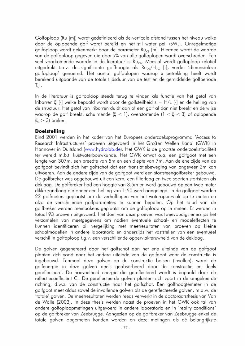
- 77 -
Golfoploop (Ru [m]) wordt gedefinieerd als de verticale afstand tussen het niveau welke door de oplopende golf wordt bereikt en het stil water peil (SWL). Onregelmatige golfoploop wordt gekenmerkt door de parameter Rux% [m]. Hiermee wordt de waarde van de golfoploop gegeven die door x% van alle golfoplopen wordt overschreden. Een veel voorkomende waarde in de literatuur is Ru2%. Meestal wordt golfoploop relatief uitgedrukt t.o.v. de significante golfhoogte als Ru2%/Hmo [-], verder ‘dimensieloze golfoploop’ genoemd. Het aantal golfoplopen waarop x betrekking heeft wordt berekend uitgaande van de totale tijdsduur van de test en de gemiddelde golfperiode T01.
In de literatuur is golfoploop steeds terug te vinden als functie van het getal van Iribarren ξ [-] welke bepaald wordt door de golfsteilheid s = H/L [-] en de helling van de structuur. Het getal van Iribarren duidt aan of een golf al dan niet breekt en de wijze waarop de golf breekt: schuimende (ξ < 1), overstortende (1 < ξ < 3) of oplopende (ξ > 3) breker.
Doelstelling Eind 2001 werden in het kader van het Europees onderzoeksprogramma ‘Access to Research Infrastructures’ proeven uitgevoerd in het Groβen Wellen Kanal (GWK) in Hannover in Duitsland (www.hydrolab.de). Het GWK is de grootste onderzoeksfaciliteit ter wereld m.b.t. kustwaterbouwkunde. Het GWK omvat o.a. een golfgoot met een lengte van 307m, een breedte van 5m en een diepte van 7m. Aan de ene zijde van de golfgoot bevindt zich het golfschot dat een translatiebeweging van ongeveer 2m kan uitvoeren. Aan de andere zijde van de golfgoot werd een stortsteengolfbreker gebouwd. De golfbreker was opgebouwd uit een kern, een filterlaag en twee soorten stortsteen als deklaag. De golfbreker had een hoogte van 3.5m en werd gebouwd op een twee meter dikke zandlaag die onder een helling van 1:50 werd aangelegd. In de golfgoot werden 22 golfmeters geplaatst om de verheffingen van het wateroppervlak op te meten en alzo de verschillende golfparameters te kunnen bepalen. Op het talud van de golfbreker werden meetbakens geplaatst om de golfoploop op te meten. Er werden in totaal 93 proeven uitgevoerd. Het doel van deze proeven was tweevoudig: enerzijds het verzamelen van meetgegevens om nadien eventuele schaal- en modeleffecten te kunnen identificeren bij vergelijking met meetresultaten van proeven op kleine schaalmodellen in andere laboratoria en anderzijds het vaststellen van een eventueel verschil in golfoploop t.g.v. een verschillende oppervlakteruwheid van de deklaag.
De golven gegenereerd door het golfschot aan het ene uiteinde van de golfgoot planten zich voort naar het andere uiteinde van de golfgoot waar de constructie is ingebouwd. Eenmaal deze golven op de constructie botsen (invallen), wordt de golfenergie in deze golven deels geabsorbeerd door de constructie en deels gereflecteerd. De hoeveelheid energie die gereflecteerd wordt is bepaald door de reflectiecoëfficiënt Cr. De gereflecteerde golven planten zich voort in de omgekeerde richting, d.w.z. van de constructie naar het golfschot. Een golfhoogtemeter in de golfgoot meet aldus zowel de invallende golven als de gereflecteerde golven, m.a.w. de ‘totale’ golven. De meetresultaten werden reeds verwerkt in de doctoraatsthesis van Van de Walle (2003). In deze thesis werden naast de proeven in het GWK ook tal van andere golfoploopmetingen uitgevoerd in andere laboratoria en in ‘reality conditions’ op de golfbreker van Zeebrugge. Aangezien op de golfbreker van Zeebrugge enkel de totale golven opgemeten konden worden en deze metingen als dé belangrijkste
- 78 -
metingen werden aanzien werd in de ganse thesis verder gewerkt met de superpositie van invallende en gereflecteerde golven. Echter, in de literatuur vindt men veelal ontwerpformules terug die golfoploop voorspellen op basis van de invallende golf aan de teen van de golfbreker en niet de totale golf. Daarom was de doelstelling van deze thesis het vergelijken van de golfoploopresultaten uit Van de Walle (2003) met de resultaten van een analyse van de meetgegevens waarbij enkel de invallende golven worden beschouwd. Een tweede doelstelling was het kwantitatief bepalen van het (eventuele) verschil tussen de resultaten bekomen uit beide werkwijzen.
Methodologie Om bovenstaande doelstellingen te bereiken werden volgende stappen ondernomen: literatuurstudie verwerking van de meetgegevens vergelijken van de resultaten met de literatuur conclusies
Om de golfmeetgegevens om te zetten naar de verschillende bruikbare golfparameters werd gebruik gemaakt van frequentieanalyse. Hierbij wordt de meetdata omgezet naar een golfspectrum d.m.v. de theorie van de discrete Fast Fouriertransformatie (FFT).
Er bestaan verschillende theorieën om totale golven te splitsen in invallende en gereflecteerde golven, zowel in frequentie- als in tijdsdomein. Bij de methodes die gebaseerd zijn op frequentieanalyse wordt uitgegaan van het feit dat de (totale) golven een som zijn van een eindig aantal regelmatige golven met verschillende frequenties en fases. De methode van Mansard en Funke werd toegepast door gebruik te maken van het softwareprogramma RefCross dat aan de Universiteit van Aalborg (Denemarken) werd ontwikkeld.
Het verder verwerken van de meetdata en het bepalen van de golfparameters gebeurde in LabView en Excel. Er werden in totaal 56 reeksen meetdata verwerkt, goed voor ongeveer 140 miljoen meetwaarden.
Het statisch verwerken en vergelijken van de resultaten gebeurde a.d.h.v. het softwareprogramma SPSS.
Resultaten Wanneer de verschillende golfparameters voor invallende golven en totale golven met elkaar vergeleken worden kan besloten worden dat:
de waarden voor de significante golfhoogte Hmo,inc van de invallende golven algemeen lager liggen dan de waarden voor de significante golfhoogte Hmo,tot van de totale golven. Naarmate hogere golven worden beschouwd, wordt het verschil tussen de significante golfhoogtes groter.
de waarden voor de piekperiode Tp,inc van de invallende golven algemeen hoger liggen dan de piekperiodes Tp,tot van de totale golven. Algemeen geldt dus een verschuiving naar de lagere frequenties voor het invallende spectrum ten opzichte van het totale spectrum.
- 79 -
voor de gemiddelde golfperiode T01 dezelfde trend kan waargenomen worden als voor Tp. De trend waarbij een hogere periode bekomen wordt voor invallende golfspectra is echter meer uitgesproken bij de gemiddelde periode T01 dan bij de piekperiode Tp.
Fig. 1. Dimensieloze golfoploop Ru2%/Hmo in functie van het getal van Iribarren ξom. In Fig. 1 is de dimensieloze golfoploop uitgezet in functie van het getal van Iribarren en dit voor zowel totale als voor invallende golven. Door de algemeen hogere waarden voor Ru2% bij invallende golven ten opzicht van totale golven liggen de meetresultaten voor invallende golven ook ten opzichte van de gemiddelde waarden van Iribarren hoger. De best passende rechte voor invallende golven ligt ongeveer 6% hoger dan de best passende rechte voor totale golven. De spreiding op de resultaten is voor beide reeksen nagenoeg gelijk: de standaardafwijking voor invallende golven bedraagt 0.23 terwijl de standaardafwijking voor totale golven 0.28 bedraagt.
Een statistische test werd uitgevoerd op de twee bekomen reeksen golfoploopdata. Uit de output van het statische computerprogramma SPSS kan, met een significantieniveau van 5%, besloten worden dat er wel degelijk een significant verschil is tussen de twee trendlijnen. Dezelfde conclusie kan getrokken worden uit de grafieken met op de abscis de waarden van het getal van Iribarren berekend met de piekperiode Tp of berekend met de spectrale periode Tm-10.
In Fig. 2 werden de waarden van de dimensieloze golfoploop voor invallende golven tegenover de waarden van de dimensieloze golfoploop voor totale golven geplaatst. Uit deze figuur kan afgeleid worden dat het verschil tussen de waarden van de dimensieloze golfoploop voor invallende golven en totale golven niet toe- of afneemt voor veranderende
- 80 -
dimensieloze golfoploop waarden. Wel valt op dat de hogere waarden voor de dimensieloze golfoploop bij totale golven vooral voorkomen bij de lagere en de hogere waarden. Algemeen kan dus gesteld worden dat dimensieloze 2% golfoploop waarden berekend aan de hand van de totale golven een onderschatting zal opleveren van de golfoploop ten opzichte van bepalingen aan de hand van invallende golven. Voor uiterste waarden zou kunnen gesteld worden dat deze stelling niet opgaat. Dit is dan vooral het geval voor lagere waarden van de dimensieloze golfoploop.
Fig. 2. Dimensieloze golfoploop Ru2%/Hmo voor invallende golven t.o.v. dimensieloze golfoploop Ru2%/Hmo voor totale golven.
De resultaten van de analyses, uitgevoerd met zowel totale als met invallende golven, werden vergeleken met de theoretische formule van van de Meer en Stam (1992). In Fig. 3 is deze theoretische functie van de dimensieloze golfoploop in functie van het getal van Iribarren, berekend met de gemiddelde periode T01, weergegeven. In dezelfde grafiek zijn ook de in deze thesis berekende waarden van de invallende en de totale golven opgenomen. Wanneer de data vergeleken wordt met de theoretische lijn van van der Meer en Stam (1992) ziet men een betere overeenkomst met de theoretische lijn voor de gegevens bekomen door analyse van de invallende golven dan voor de gegevens bekomen door analyse van de totale golven.
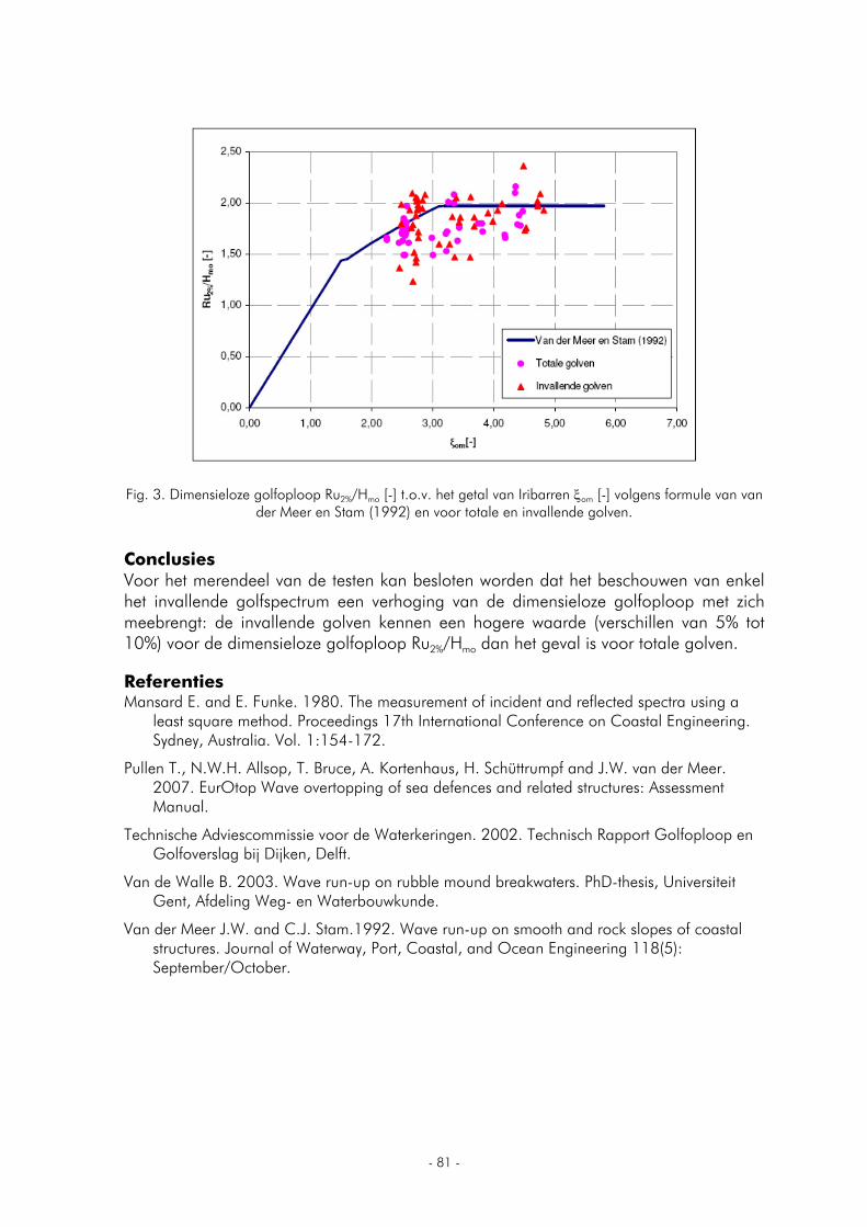
- 81 -
Fig. 3. Dimensieloze golfoploop Ru2%/Hmo [-] t.o.v. het getal van Iribarren ξom [-] volgens formule van van der Meer en Stam (1992) en voor totale en invallende golven.
Conclusies Voor het merendeel van de testen kan besloten worden dat het beschouwen van enkel het invallende golfspectrum een verhoging van de dimensieloze golfoploop met zich meebrengt: de invallende golven kennen een hogere waarde (verschillen van 5% tot 10%) voor de dimensieloze golfoploop Ru2%/Hmo dan het geval is voor totale golven.
Referenties Mansard E. and E. Funke. 1980. The measurement of incident and reflected spectra using a
least square method. Proceedings 17th International Conference on Coastal Engineering. Sydney, Australia. Vol. 1:154-172.
Pullen T., N.W.H. Allsop, T. Bruce, A. Kortenhaus, H. Schüttrumpf and J.W. van der Meer. 2007. EurOtop Wave overtopping of sea defences and related structures: Assessment Manual.
Technische Adviescommissie voor de Waterkeringen. 2002. Technisch Rapport Golfoploop en Golfoverslag bij Dijken, Delft.
Van de Walle B. 2003. Wave run-up on rubble mound breakwaters. PhD-thesis, Universiteit Gent, Afdeling Weg- en Waterbouwkunde.
Van der Meer J.W. and C.J. Stam.1992. Wave run-up on smooth and rock slopes of coastal structures. Journal of Waterway, Port, Coastal, and Ocean Engineering 118(5): September/October.
- 82 -
BIOACCUMULATIEMODEL VOOR MICROCONTAMINANTEN BIJ DE GEWONE ZEEHOND (PHOCA VITULINA) EN BRUINVIS (PHOCOENA PHOCOENA)
Weijs Liesbeth
Universiteit Antwerpen (UA), Departement Biologie, Onderzoeksgroep Ecofysiologie, Biochemie en Toxicologie (EB&T), Campus Middelheim, Groenenborgerlaan 171 - Gebouw U, 2020 Antwerpen E-mail: [email protected]
Inleiding De afgelopen decennia hebben talrijke studies aangetoond dat microcontaminanten aanzienlijke concentraties kunnen bereiken in organismen die steeds hoger staan in de voedselketen. Dit kan teruggevonden worden bij gewone zeehonden (Phoca vitulina) en bruinvissen (Phocoena phocoena). Beide soorten staan aan de top van het Noordzee-ecosysteem en accumuleren bijgevolg microcontaminanten, zoals zware metalen en persistente organische polluenten, in hun weefsels. Deze chemicaliën vertonen, door hun fysische en chemische eigenschappen, vaak een andere verspreiding, andere accumulatie-patronen en verschillende toxicologische werkingsmechanismen. Het opstapelen van contaminanten kan dan ook resulteren in effecten op meerdere systemen, waaronder het reproductief (Reijnders, 1986), het endocriene (Beineke et al., 2005) en het immuunsysteem (Ross et al., 1996). Bij gewone zeehonden en bruinvissen wordt de aanwezigheid van POP’s (Persistente Organische Polluenten), zoals PCB’s (polychloorbifenylverbindingen) al langer onderzocht, maar recent wordt er meer en meer aandacht gegeven aan het voorkomen en mogelijke effecten van PBDE’s (polybroomdifenylethers) bij deze dieren.
Initiële doelstelling Het analyseren van stalen van blubberweefsel van Phoca vitulina (gewone
zeehonden)en Phocoena phocoena (bruinvissen), afkomstig uit de Noordzee, voor PCB’s (polychloorbifenylverbindingen) en PBDE’s (polybroomdifenylethers) om de aanwezigheid en trends van deze stoffen in de Noordzee en in de dieren te kunnen evalueren.
Het opstellen van een algemeen bioaccumulatiemodel om een beter inzicht te krijgen in de opname en vooral eliminatie van microcontaminanten in beide soorten zeezoogdieren en het evalueren hiervan bij gewone zeehonden en bruinvissen door gebruik te maken van data uit de literatuur, uit bestaande databanken (CEFAS: Centre for Environment, Fisheries and Aquaculture Science) en eigen analyses (zie eerste doelstelling) van de meest persistente en bijgevolg best gedocumenteerde PCB, namelijk CB 153.
Methodologie De procedure die gevolgd werd voor het analyseren van de stalen, staat beschreven in Covaci et al. (2002) en Voorspoels et al. (2003; 2004), maar zal hier kort worden uitgelegd. Er werd een kleine hoeveelheid blubberweefsel gedroogd met natriumsulfaat waarna er interne standaarden werden toegevoegd. De extractie gebeurde in een hete
- 83 -
Soxhlet. Een deel van het extract werd vervolgens gebruikt voor de bepaling van het vetgehalte, het overblijvende deel van het extract werd opgezuiverd op zure silica en verder geconcentreerd. Er werden 21 PCB congeneren en 10 verschillende PBDE-congeneren gedetecteerd met de GC-MS (gaschromatografie-massaspectrometrie) techniek. De kwaliteit van de analysen werd gegarandeerd door een regelmatige deelname van het labo aan interlaboratoriumtesten en door de procedure uit te voeren met blanco’s en referentiestalen. De resultaten werden statistisch verwerkt met behulp van ANOVA-procedures, aangevuld met Tukey-testen.
Resultaten Analyseresultaten van het blubberweefsel van bruinvissen en gewone zeehonden uit de Noordzee laten zien dat locatie, leeftijdsklasse en geslacht belangrijke parameters zijn bij het accumuleren van bepaalde POP’s. Voor PCB’s werden de algemene trends bevestigd: mannelijk adulte bruinvissen en zeehonden vertoonden de hoogste concentraties van PCB’s door een continue bioaccumulatie, terwijl vrouwelijke adulte dieren de laagste concentraties hadden door lactatie en zwangerschap. Nederlandse zeehonden bleken dan weer meer gecontamineerd te zijn dan Belgische dieren, terwijl er geen verschil gevonden kon worden tussen Engelse bruinvissen en hun Belgische soortgenoten. Deze trends en verschillen waren minder uitgesproken voor PBDE’s bij beide soorten. Het belangrijkste resultaat voor PBDE’s was het verschil in locatie, maar parameters zoals leeftijdsklasse en geslacht leken, ondanks kleine verschillen in concentraties tussen groepen, minder belangrijk. Wanneer beide soorten met elkaar vergeleken werden, bleek dat bruinvissen een minder efficiënt metabolisme leken te hebben dan gewone zeehonden. Belangrijke besluiten voor dit onderdeel waren enerzijds dat de capaciteit tot het metaboliseren tussen diersoorten kan verschillen en dat de structuur van de molecule een grote rol speelt binnen het bioaccumulatieproces.
Het theoretisch bioaccumulatiemodel dat werd opgesteld voor bruinvissen en gewone zeehonden volgens Blust (2001) vertoonde, ondanks het ontbreken van gegevens ivm eliminatiepathways in de literatuur, overeenkomsten met de modellen die werden gemaakt met data uit de bestaande databanken (CEFAS), literatuur en uit eigen analyse. Het besluit van dit onderdeel was dat theoretische bioaccumulatiemodellen niet alleen gebruikt kunnen worden om concentraties in de dieren te verklaren, maar dat deze ook een voorspellende waarde kunnen hebben.
Referenties
Beineke A., U. Siebert, M. McLachlan, R. Bruhn, K. Thron, K. Failing, G. Müller, and W. Baumgärtner. 2005. Investigations of the potential influence of environmental contaminants on the thymus and spleen of harbor porpoises (Phocoena phocoena). Environmental Science & Technology 39:3933–3938.
Blust R. 2001. Dispersion and transfer in the aquatic environment: radionuclide accumulation in freshwater organisms: concepts and models. In: Radioecology, radioactivity and ecosystems. p.57–89. Van der Stricht E. and R. Kirchmann (Eds). 2001. Liège, Fortemps. 603p.
- 84 -
Covaci A., K.I. Van de Vijver, W. De Coen, K. Das, J.M. Bouquegneau, R. Blust, and P. Schepens. 2002. Determination of organohalogenated contaminants in liver of harbour porpoises (Phocoena phocoena) stranded on the Belgian North Sea coast. Marine Pollution Bulletin 44:1157–1165.
Reijnders P.J.H. 1986. Reproductive failure in common seals feeding on fish from polluted coastal waters. Nature 324:456–457.
Ross P.S., R.L. De Swart, H.H. Timmerman, P.J.H. Reijnders, J.G. Vos, H. Van Loveren, and A.D.M.E. Osterhaus. 1996. Suppression of natural killer cell activity in harbour seals (Phoca vitulina) fed Baltic Sea herring. Aquatic Toxicology 34:71–84.
Voorspoels S., A. Covaci, J. Maervoet, I. De Meester, and P. Schepens. 2004. Levels and profiles of PCBs and OCPs in marine benthic species from the Belgian North Sea and the Western Scheldt Estuary. Marine Pollution Bulletin 49:393–404.
Voorspoels S., A. Covaci, and P. Schepens. 2003. Polybrominated diphenyl ethers in marine species from the Belgian North Sea and the Western Scheldt Estuary: levels, profiles, and distribution. Environmental Science and Technology 37:4348–4357.
- 85 -
APPLICANTS VLIZ North Sea Award 2007
- 86 -
INTERFERENCE COMPETITION AND PATCH CHOICE IN FORAGING SHORE CRABS
Smallegange Isabel
Royal Netherlands Institute for Sea Research (NIOZ), Landsdiep 4, PB 59, 1790 AB Den Burg, Texel, the Netherlands Present address: Max Planck Institute of Ornitology, Vogelwarte Radolfzell, Schlossallee 2, 78315 Radolfzell, Germany E-mail: [email protected]
Understanding the foraging decisions and the mechanisms that underlie the dispersal behaviour of foragers is of central importance in answering questions aimed at assessing the processes that determine the spatial distribution of species. The studies in this thesis aim to contribute to answering the question ‘why do predators forage where they forage?’.
While foraging, animals regularly compete over (access to) food in direct, aggressive interactions. These interactions deprive individuals of time that was otherwise available for foraging and this reduces their feeding rate: a process that has been termed interference competition. To formulate hypotheses on the strength of interference competition in relation to the presence of competitors and prey availability, the so-called generalized functional response model is used. The generalized functional response relates the per capita feeding rate of predators to the prey and predator (=competitor) density in a certain food patch. If the generalized functional response is known, one can subsequently derive predictions on how predators distribute themselves across patches of different quality using the theory of ideal-free distributions (IFD). This theory forms a widely used starting point for formulating hypotheses on the spatial distribution of foraging animals. IFD theory predicts the distribution of animals that are omniscient (‘ideal’), and that experience no travelling costs (‘free’) while moving to the patch that maximises their feeding rate. In the first, and most basic IFD model, animals are assumed to be of equal competitive ability. In that case, ideal and free animals distribute themselves such that the per capita feeding rate – as defined by the generalized functional response – is equal and constant across patches. The per capita feeding rate is determined by the generalized functional response model that is used. However, various generalized functional response models have been presented in the literature, and each one results in a different prediction on the spatial distribution of foraging predators. This means that in order to understand why predators forage where they forage, firstly, detailed knowledge on the foraging behaviour, i.e. the generalized functional response, of predators is required. This notion has formed the key motivation for the work conducted in this thesis.
Critical to investigating the strength of interference competition in foraging predators and its effect on their choice of food patch is that prey densities are kept at a (almost) constant level. The reason for this is that, otherwise, effects of exploitation competition (the overall reduction of prey availability as more prey are consumed) obscure effects of interference competition. What is more, models of the generalized functional response and IFD models assume constant prey densities. Therefore, a novel experimental approach was developed to keep prey densities at an almost constant level (Chapter 5)

- 87 -
so that the interference competition and patch choice of shore crabs (Carcinus maenas) foraging on mussels (Mytilus edulis) could be studied.
The first part of this thesis work (Chapter 2, 3 and Box III) was concerned with investigating how shore crabs handle (i.e. break and eat) mussels, what sizes of mussels shore crabs prefer, and how many mussels of which size shore crabs can eat before being satiated. These studies were done to assure that in all subsequent experiments, shore crabs always foraged on mussels that they could handle easily and that were of a size close to what they prefer, without reaching satiation levels (as that would stop shore crabs from foraging).
In the second part of this thesis work, the generalized functional response was assessed for shore crabs of equal competitive ability (Chapter 5). Since, in shore crabs, competitive ability is strongly correlated with their size, this means that only shore crabs of equal size were used. Continuous observation of the foraging behaviour of equal shore crabs showed that they suffered interference competition as they lost foraging time while being engaged in agonistic interactions (remember that prey densities were kept at an almost constant level to reduce effects of exploitation competition). The strength of interference competition increased with increasing crab density. These results were used to construct behavioural models in which the foraging and agonistic behaviours as observed in Chapter 5 were defined. That is, a Markov chain was developed that describes the foraging process of a few predators of equal competitive ability moving from one state of the foraging process to the next (Chapter 6). Each state of the foraging process is a combination of behaviours that the predators can display, for example, two predators can be searching, one can be searching the other handling, or both are fighting. If one of two searching predators finds a prey item, the foraging process moves from the ‘both are searching’ state to the ‘one is searching, one is handling’ state. If the duration and frequency of each behaviour as defined in the Markov chain can be measured in behavioural experiments, these models can be parameterised and put to the test. This was done in Chapters 6 and 7 for shore crabs of equal competitive ability. The predictive power of the model is high as there was a good fit between predicted and observed feeding rates (Chapter 7).
Subsequently, the Markov chain was extended to describe the foraging process of two (equal) predators foraging on two food patches of different quality (different prey densities), assuming that crabs have no preference for either patch (Chapter 8). This Markov chain was used to formulate a null hypothesis on the distribution of two shore crabs across two food patches. Specifically, the null hypothesis gives (1) the per capita feeding rate of the shore crabs on each food patch and (2) the amount of time each shore crab spends on a patch if they have no preference for either patch. Also, an alternative hypothesis, the ideal-free hypothesis, was formulated and for that purpose the results of Chapters 5 and 9 were used to predict (1) on which food patch shore crabs stay and (2) what their per capita feeding rate is if they aim to maximise their feeding rate, taking patch quality and number of competitors present into account. The two predictions on patch choice (no-preference versus ideal-free) were tested in Chapter 8 (prey densities were again kept at a constant level), which showed that crabs maximised their feeding rate by taking prey from the best food patch, in line with the ideal-free hypothesis. However, crabs did not stay on the best patch, but adopted a ‘take-away’ strategy whereby they carried prey away to consume it on the poor patch,
- 88 -
away from the competitor and thereby reducing interference. As a result, the time spent on each patch did not differ from that expected under the no-preference hypothesis.
The third part of this thesis work focussed on predators that differ in competitive ability. Firstly, the generalized functional response was assessed for shore crabs that forage in the presence of competitors of unequal competitive ability (unequal size) (Chapter 9). The results of the experiments revealed that interference competition between foraging shore crabs was greatest between individuals of equal competitive ability. This observation, together with predictions from the field of game theory (Chapter 4), was the motivation to explore how this would alter conclusions of current IFD models, as they are based on the premise that individuals suffer interference the most from dominant (larger) competitors. To this end, the equal predators Markov chain (Chapters 6 and 7) was adjusted for the fact that interference is stronger between two equal predators while searching than between two unequal predators (Chapter 10). New insights were gained from the behavioural observations in Chapter 9. The rules of interference in shore crabs as determined from Chaptre 5 were therefore improved and the Markov chain differs from that used in part two. Parameterizing this new Markov chain proved difficult as not all state durations could be measured from the behavioural data of Chapter 9, and an alternative procedure was used to arrive at parameter estimates (Chapter 10). The Markov chain applies to a small number of predators. However, to assess how strong interference between equal competitors affects their ideal-free distribution, a behavioural model is needed that applies to a large number of predators. Therefore, the behavioural rules of the Markov chain on interference and foraging were used to develop a generalized functional response model (the two-phenotypes interference model) for a large number of subordinate and dominant predators (Chapter 10). Using the new parameter estimates, ideal-free predictions on patch choice were derived. The model predicts that over a large range of predator densities, predators distribute themselves in a mixed manner with a larger share of dominants on the better patch, but with complete overlap of feeding rates of dominants and subordinates across patches. This contrasts with the predictions from many IFD models, where individuals suffer most from dominant competitors, which results in complete or partial segregation of the predator population by competitor type across food patches. The IFD prediction from Chapter 10 was tested in the laboratory (Chapter 10) and in the field (Chapter 11). In the lab, a large group of subordinate (small) and dominant (large) crabs foraged on two large mussel patches. Crabs, however, did not conform to the ideal-free assumption of omniscience, and the ideal-free prediction could not be tested. In the field, it was assumed that the quality of sampling sites was set by the abundance of brown shrimps (Crangon crangon: a preferred prey species). The observed spatial distribution of crabs pointed at a mixed, ideal-free distribution in line with the model prediction: expected feeding rates of dominant and subordinate crabs were similar across sampling sites at three intertidal mudflats in the western Wadden Sea (Chapter 11). However, the actual foraging behaviour of crabs was not observed and alternative hypotheses, such as that foraging decisions are determined by reducing the risk of predation by con- en heterospecifics, should also be considered. Because the distances between adjacent food ‘patches’ (i.e. sampling sites) in the field were large (3, 100 or 500m), a discrepancy between food intake and time spent in a patch is not expected, as was observed in the lab study where patches were immediately adjacent to each other (Chapter 8).
- 89 -
Has this thesis work increased the understanding of the processes that determine the spatial distribution of foragers? The results presented in this thesis show the impact of interference competition in foraging shore crabs and the relationship between prey availability and presence of others on the choice of food patch. New insights have been gained, such as the ‘take-away’ strategy, and current generalized functional response models have been improved. However, no hypothesis formulated in this thesis work on the foraging behaviour of predators across different food patches has unequivocally been confirmed. Furthermore, in this thesis work, assumptions have been made that may create (unforeseen) pitfalls, which are discussed in the final chapter, Chapter 12. These pitfalls, together with insights from the results of this thesis work, give rise to future lines of research that are outlined in Chapter 12. If pursued, they will contribute further to answering the question ‘why do animals forage where they forage’, and deepen the understanding of the processes that determine the spatial distribution of species such as shore crabs.
- 90 -
EXPOSURE AND EFFECT ASSESSMENT OF PERFLUORINATED ALKYLATED SUBSTANCES IN MARINE AND ESTUARINE ORGANISMS
Van de Vijver Kristin (Inneke)
University of Antwerp, Department of Biology, Group of Ecophysiology, Biochemistry and Toxicology, Campus Middelheim, Groenenborgerlaan 171 - Gebouw U, 2020 Antwerpen, Belgium E-mail: [email protected]
Since several decades, interest has grown by scientists as well as policy makers, that environmental pollution threatens the biological structure and function of estuarine and coastline ecosystems. One of the most crucial and urgent aspects of the environmental monitoring policy is to unravel ‘new chemicals’ and to document the risks caused by these new substances, which often circulate already for decades in the environment. Persistent chemicals, like the halogenated organochemicals, have been studied very intensely, however, within this important group of substances, perfluorinated alkylated substances (PFAS) have escaped to the attention of environmental toxicologists.
Nevertheless, PFAS such as perfluorooctane sulfonate (PFOS) and perfluorooctanoic acid (PFOA), as well as their related products, are being produced over 50 years and have a broad application spectrum in industry and households. These compounds are stable and chemically inert and therefore, always considered as being safe for humans and environment. The presence of fluorine in human blood has been reported for the first time in 1968. However, it took several decades before other research studies reported on the occurrence of alarmingly high levels of PFAS in the aquatic and terrestrial environment. In addition, they tend to accumulate along the food chain. Among the effects known are induction of peroxisomal β-oxidation, induction of microsomal liver carboxylesterase, membrane-related effects, and developmental problems in Rodentia and fish.
Nowadays, public concerns about the persistence and the toxicological effects of PFAS have increased. However, a detailed quantitatively description of their distribution in the European aquatic environment is lacking.
This doctoral thesis tried to give a better insight in the following research questions:
1) what are the actual concentrations of perfluorinated alkylated substances occurring in biota from the European estuarine and marine environment and is there a difference in accumulation pattern between various tissues,
2) is there an influence of trophic position and/or feeding ecology on the levels of perfluorinated compounds in marine mammals, and
3) what are the biochemical and molecular effects of water exposure to PFOS?
We focused mainly on the European marine and estuarine environment, namely the southern North Sea and the Western Scheldt Estuary, the northern North Sea and Baltic area and the Black Sea.
- 91 -
With the exception of Chapter 2 in which invertebrates [starfish (Asterias rubens), crab (Carcinus maenas) and shrimp (Crangon crangon)] were used, and Chapter 7 in which the European sea bass (Dicentrarchus labrax) was used, all chapters studied marine mammals, because they are situated at the higher levels of the food chain and will therefore most probably suffer most from these new types of pollutants. PFAS levels have been quantified using high performance liquid chromatography combined with electrospray tandem mass spectrometry (HPLC-MS/MS).
The first two questions addressed in this study were answered in Chapters 2 to 6. Results of a biomonitoring study performed in the Western Scheldt Estuary and the Southern North Sea, showed concentrations on a wet weight basis in soft tissues of shrimp, crab and starfish that ranged from 19 to 520ng.g-1, from 24 to 877ng.g-1 and from 9 to 176ng.g-1, respectively. These concentrations were higher compared to invertebrate studies using bivalves and studies determining PFOS in shrimp and zooplankton from the Canadian Arctic. Furthermore, the study results demonstrated a clear PFOS pollution gradient along the Western Scheldt, with higher levels in crab and shrimp near Antwerp (Chapter 2). This might be explained by the presence of a major fluorochemical manufacturing facility near the harbour of Antwerp, and the large domestic and industrial wastewater discharges further upstream.
The highest individual PFOS concentrations were determined in tracheo-bronchial muscle from a harbour seal stranded along the Dutch coast of the Wadden Sea (2724ng.g-1 wet wt; Chapter 5) and in liver tissue of a harbour porpoise from the Ukrainian Black Sea (1790 ng.g-1 wet wt; Chapter 6). The levels measured in marine mammals from the North Sea and adjacent areas are comparable to PFOS concentrations found in marine mammals from all over the world. Concentration differences are mainly due to spatial and temporal variation (e.g. the proximity of possible pollution sources) and to inter-species differences in uptake rate, metabolism and excretion potential.
The same can be concluded concerning the different tissue patterns. In Chapter 5 and 6, tissue distribution of perfluorinated compounds in seals and porpoises was investigated. The difference in tissue concentrations might be a consequence of spatial (Wadden Sea versus Black Sea) and inter-species variation. Both species share some of their prey species, but differ in trophic position and metabolism of organic pollutants, which might explain the difference in toxic levels.
The influence of gender and age was investigated if sample size allowed the comparison between respectively male and females, and juveniles and adults. Only in a few cases, significant differences (p<0.05) were obtained. The lack of clear age or sex-related differences in concentrations of PFOS is a general observation in all biomonitoring surveys. Apparently, PFAS have a very different accumulation pattern than other persistent organic pollutants which decrease with age in female organisms because of the transfer to their young. Although there is no observation that adult females have lower PFAS levels like with DDTs and PCBs, there might be another transfer from mother to offspring as foetuses from different species showed much higher PFOS concentrations than their mothers (Chapter 4). However, this potential transfer still has to be determined.
- 92 -
Concentrations of other perfluorinated compounds like the perfluorinated carboxylates (PFCAs) were fairly low in all species and all tissues analysed. In general, PFCAs were present at detectable concentrations in those samples with the highest PFOS concentrations. Concentrations generally decreased for all PFCA homologues with increasing chain length. A remarkable difference between harbour porpoises and seals was that the dominant PFCAs in all porpoise samples were PFDA and PFUA, and PFNA could only be detected in 41% of the samples. In the seal samples, however, PFNA was the major compound, followed by PFDA. Probably there is a difference in metabolism between the two species, although no clear explanation can be given.
Only in spleen tissue from harbour seals, perfluorobutane sulfonate (PFBS) could be detected at concentrations ranging from 1.74 to 3.28ng.g-1 ww. Until now, studies on PFBS, showed that PFBS did not bioconcentrate in organisms to levels greater than the concentrations to which they were exposed and that this compound was rapidly cleared from the body, with an elimination half-life of hours in rats and a few days in primates. So far, no clear explanation can be given to the fact that PFBS was detected, although at very low concentrations, in spleen tissue and no one knows what the possible consequences might be for the animal.
In order to provide an answer to the second question, we have considered that trophic position and feeding ecology might be important factors with which we could explain some of the variation in concentrations of perfluorinated compounds seen in marine mammals. Therefore, we have tried to link the obtained PFAS concentrations to stable nitrogen (15N/14N) and carbon (13C/12C) isotope ratios. The use of stable isotope ratios has evolved to a powerful tool to study element cycles and various biological, physical and chemical processes in different research areas. In marine mammals, this technique has been used to study migrations, trophic ecology and pollution. Briefly, the higher the trophic position of an animal the higher the δ15N value will be. In addition, δ13C values indicate if animals are offshore and/or pelagic feeders (low δ13C values), or more inshore and/or benthic feeders (high δ13C values).
Our results indicate that the 15N/14N ratio was strongly associated with PFOS concentrations in livers of marine mammals, with animals that displayed the highest trophic positions, namely harbour and grey seals and white-beaked dolphins, having the highest PFOS levels. Offshore feeders originating from the southern North Sea such as sperm whales, fin whales, striped dolphin and white-sided dolphin showed low 13C/12C ratios and were also having lower PFOS concentrations than inshore species (Chapter 3). PFOS levels up to 50ng.g-1 wet wt in sperm whales which feed mainly on abyssal cephalopods, but also on bottom-dwelling organisms, suggest that fluorinated organic compounds have not only reached remote Arctic regions, but also deeper water layers.
Stable isotope ratios were also applied in Chapter 4 where the significant difference in mean δ13C values between two distinct Norwegian populations of harbour porpoises could also be detected in the PFOS concentrations. Apparently, porpoises feeding in more inshore areas, were having higher hepatic PFOS levels. In addition to this last observation, shrimp, starfish and crabs collected at marine locations closer to the Belgian shore had higher PFOS levels than those collected at open sea locations (Chapter 2). Discharges of PFOS from the coastal zone into the aquatic environment
- 93 -
might be the reason why concentrations near the coast are slightly higher than further into sea.
In Chapter 7, we tried to characterize the toxicological mechanism of PFOS in the European sea bass, Dicentrarchus labrax (Moronidae) using selected biochemical endpoints (e.g. serum alanine aminotransferase activity (ALT), serum electrolyte levels and hematocrit) and molecular responses (using cDNA microarrays). For the latter purpose, a recently established technique for differential gene expression, Suppression Subtractive Hybridization-Polymerase Chain Reaction (SSH-PCR), has been used in combination with cDNA microarrays.
Juvenile fish were exposed to four different PFOS concentrations (0.1; 1; 10 and 100 mg.l-1) via water and after 14 days effects were assessed in liver and serum. It was remarkable that within a rather short space of time there was already a very high and rapid accumulation, even at the lowest exposure doses. The liver PFOS concentration was positively and significantly related to both ALT activity and total serum protein content, and significant negative relations were found with the serum Na+ and K+ concentrations and the hematocrit values.
Multiple gene expression profiles were examined and we were able to isolate several genes that were up or down regulated after a short-term exposure. A total of 195 cDNAs were differentially expressed in liver tissue of sea bass after exposure to PFOS. Although DNA sequence data are poorly represented in the public data base for non-model species, 28 cDNAs could be identified by homology. Major functional classes of differentially expressed genes included oxidative stress related genes, genes involved in energy or iron/heme metabolism, genes which play a role in the immune system, translation and/or transcription processes and signal transduction. Interesting in our data was the influence on genes which are known to respond to organic pollutants and are involved in detoxification (28% of the genes). Eight of the identified clones corresponded to genes of the cytochrome P450 family (subfamilies 1, 2 and 3). The majority of these genes were up regulated after PFOS exposure. The induction of hepatic cytochrome P450 isomers can lead to DNA-adduct formation and carcinogenesis. The data obtained in this study identified several genes whose mRNA was regulated after PFOS exposure suggesting an array of hypotheses which could be tested to reveal the toxicological mode of action of perfluorinated chemicals.
At the end of this thesis we have generated a better insight into the hazard that is caused by perfluorinated chemicals for marine and estuarine organisms. This is crucial to ensure ecosystem health and to minimize the exposure towards these highly persistent and potentially hazardous chemicals. Results from biomonitoring and toxicological studies like the ones in this doctoral thesis might have additional value for producers and policy makers in order to set up some regulations. In 2000, 3M, one of the biggest producers of PFAS in the United States, has announced the phase out of the production of PFOS-based chemicals from December 2000 and to stop external sale of PFOA. New studies on the accumulation of PFOS and related chemicals in biota, should be performed in the near future to investigate if the phase-out has led indeed to a reduction of PFOS in the environment as was expected. In addition, due to the introduction of a Significant New Use Rule (SNUR), there is now the possibility for the government of the US to evaluate every new application in which PFAS are used.
- 94 -
To our knowledge, there are still no clear European or Belgian regulations on PFAS. For the moment, the OECD (Organisation for Economic Co-operation and Development) is trying to map the production and uses of PFAS in the entire European Union. Great Britain and Sweden have made some proposals for their own national legislation, but the European Commission has frozen these regulations as the European Commission is working on a draft concerning the production or use of PFAS within the framework of Directive 76/769/EEC. Other regulation processes within Europe are the nomination of PFOS under the UNECE POP LRTAP protocol (United Nations Economic Commission for Europe, Convention on Long-range Transboundary Air Pollution concerning persistent organic pollutants) and the UNEP (United Nations of Europe) POPs protocol of the Stockholm Convention.
- 95 -
THRESHOLDS AND SHIFTS: CONSEQUENCES OF HABITAT MODIFICATION IN SALT-MARSH PIONEER ZONES
van Wesenbeeck Bregje K.
Centre for Estuarine and Marine Ecology, NIOO-KNAW, Korringaweg 7, Postbus 140, 4400 AC Yerseke, the Netherlands Present address: WL/Delft Hydraulics, PO Box 177, 2600 MH Delft, the Netherlands E-mail: [email protected]
The topic of ecosystem engineering received tremendous attention since its introduction a decade ago. However, generalizations on its consequences and effects are still scarce. In this thesis, I examine implications of habitat modification on ecosystem dynamics, species interactions, and spatial structure, with a special emphasis on effects on different scales. Research was conducted in intertidal habitats, mainly in the transition zone between salt marshes and intertidal flats, also called the salt-marsh pioneer zone. This zone is characterized by patchily distributed tussocks of the grass Spartina anglica and home to several strong ecosystem engineers. I found that interactions between organisms and the environment are an important shaping force in salt-marsh pioneer zones. Such small-scale engineering activities influence ecosystem structure, and determine ecosystem dynamics, on species, community, and landscape scales.
Field surveying revealed that in areas with strong hydrodynamic forcing, more voluminous Spartina mounds are surrounded by deeper gullies than Spartina mounds with smaller volumes. Transplantation of small Spartina clumps showed that, compared to a control, Spartina growth inside tussocks was higher, but next to the tussocks, inside the gully, Spartina growth was significantly lower. These scale-dependent feedback effects might restrict tussock expansion and influence large-scale complexity of salt-marsh systems.
Another process causing patchiness in salt-marsh pioneer zones is the interaction between Spartina and the lugworm Arenicola. Both species occur in alternating patches in the pioneer zone. In these patches they modify soil conditions, thereby inhibiting invasion of the other species. These negative species interactions by ecosystem engineering may be a mechanism underlying invasions once engineering effects of a single species prevail. However, if two engineers affect the environment in opposite ways, a patchy landscape will develop. Thus, habitat modification can be a mechanism for negative species interactions, which can be seen as a negative equivalent of facilitation (changing the environment in a positive way for other species). Similar to facilitation one expects to find this process mainly in stressful systems and this bears important consequences for community assembly models. Further, the strong patchiness that can be induced by habitat modification underlines the need for setting the proper scale when investigating ecosystem engineering effects.
Patches in salt-marsh pioneer zones are generally dense and show sharp transitions with surrounding sediment. To test whether Spartina could also establish with low biomass or
- 96 -
if a threshold for vegetation establishment was present in the system, different size classes of Spartina clumps were transplanted into bare patches of several salt-marsh pioneer zones. Only large Spartina clumps (more than 20 stems) survived, pointing at the presence of a threshold for vegetation establishment. A threshold effect results in non-linear vegetation dynamics, which complicates prediction of vegetation response in relation to changes in environmental parameters. This leads us to hypothesize that sudden and unexpected shifts can take place between the vegetated and bare state in salt-marsh pioneer zones. If this is a common characteristic of transition zones between ecosystems in general, the vulnerability of transition zones to environmental change in response to global change will be an important direction for future research.
Finally, ecosystem engineering effects were put into a landscape perspective by studying the effect of hydrodynamic stress on species interactions in a community facilitated by Spartina. Spartina supported a highly diverse community with intermediate stress conditions, and a monoculture of the competitive dominant grass species with very benign conditions. This demonstrates that ecosystem engineering effects on biodiversity differ with differing physical stresses, illustrating the need to make specific assumptions on background conditions when examining effects of ecosystem engineering.
Concluding, ecosystem engineering effects in salt-marsh pioneer zones vary with changing scale and with differing background stresses. This thesis illustrates that small-scale habitat modification can result in scale-dependent feedbacks, negative species interactions via the environment, non-linear ecosystem behavior, emergent patterns or complexity on landscape scales, and development of distinct habitats along stress gradients.