Embed Size (px)
Citation preview
GEOSPATIAL ANALYSIS OF THE EX-MINING LAND OFMELAKA
Ramli Mohd Osman1 & Lam Chee Siong2
1Mineral Research Centre, Minerals and Geoscience Department MalaysiaJalan Sultan Azlan Shah, 31400 Ipoh
2Bahagian Pemetaan Topografi Semenanjung, Jabatan Ukur dan Pemetaan Malaysia (JUPEM), Tingkat Bawah, Bangunan CAMS, Jalan Semarak, 50578 Kuala Lumpur
Email: [email protected]
ABSTRACT
To carry out geospatial information studies of the ex-mining land and to propose the most suitable development of the idle ex-mining land of Melaka, geospatial analyses were conducted on the current land-use, ex-mining land, lithology, location of mines and quarries, and the availability of metallic and industrial mineral resources for each of the 3 districts in the state. The paper discusses the result of these studies. The largest extend of ex-mining land in Melaka was in 1975, i.e. 761 ha. However, the ex-mining land has been developed and digital data obtained from Department of Agriculture (DOA) in 2000 shows that the total ex-mining land area in Melaka covers only 367 ha or 0.22% of the state of Melaka (165,606 ha). Geospatial analysis also shows that there are 74.5 ha of idle ex-mining land, which has the potential to be developed, in Melaka. Jasin has 4 idle ex-mining land areas with the largest acreage, 72.6 ha. This is followed by Alor Gajah that has 2 idle ex-mining land areas totaling 1.9 ha. The proposed development of these idle ex-mining land is discussed.
Keywords: geospatial analysis, ex-mining land, land-use, lithology, mines and quarries
1.0 INTRODUCTION
Mineral Research Centre (PPM), Minerals and Geoscience Department (JMG) Malaysia is undertaking a project to develop a digital database for the distribution of ex-mining land and to study the geospatial information on the development of idle ex-mining land in Malaysia. The project is carried out in the Tenth Malaysia Plan (RMKe-10).
To meet this objective, several efforts have been made to develop the digital database and to study the geospatial information on the development of idle ex-mining land (Ramli et al., 2011a; Ramli et al., 2011b; Ramli et al ., 2011c; Ramli & Mohd Anuar, 2012a; Ramli & Mohd Anuar, 2012b; Ramli, 2013a; Ramli, 2013b; Ramli, 2013c; Ramli & Mohd Anuar, 2013; Ramli et al., 2013; Ramli, 2014a; Ramli, 2014b; Ramli,
1
2014c; Ramli, 2014d; Ramli, 2014e; Ramli, 2014f; Ramli, 2014g; Ramli & Meor Abdul Rahman, 2014; Ramli & Nor Azlin, 2014).
In this paper, geospatial analyses of current land-use, ex-mining land, lithology, location of mines and quarries, and metallic and industrial mineral resources for each of the 3 districts in Melaka were done on screen using ArcGIS 10.2 with GDM2000 coordinate system. The paper discusses the result of these studies and proposes the most suitable development of the idle ex-mining land in the state.
2.0 MATERIAL
Current land-use digital map of Melaka was obtained from the Department of Town and Country Planning (JPBD) Melaka. The years the land-use were gazetted for each district in Melaka are as follows:
1 Alor Gajah: 2011 2 Melaka Tengah: 2008 3 Jasin: 2011
Digital ex-mining land map of Melaka was obtained from the Department of Agriculture (DOA) Malaysia. It shows the distribution of ex-mining land in Melaka in 2000. This digital map was chosen as the base map because it shows the largest extend of digital ex-mining land in the state.
Lithology digital map of Melaka (2008), digital maps of metallic and industrial mineral resources of Melaka (2008), and digital maps of mines and quarries of Melaka (2011) were obtained from JMG Malaysia. Cadastral digital data (2008) were obtained from the Department of Survey and Mapping Malaysia (JUPEM).
3.0 GEOSPATIAL ANALYSES
3.1 Current land-use of Melaka
Geospatial analysis shows that most of the current land-use of Melaka is under agriculture, 108,487 ha (65.5%), followed by idle land, 15,511ha (9.4%); residential, 11,100 ha (6.7%); forest, 7,926ha (4.8%); others, 7,877 ha (4.8%); institutions and public facilities, 4,234ha (2.6%); infrastructure and utilities, 2,382ha (1.4%); water bodies, 2,051ha (1.2%); open space and recreation, 1,936 ha (1.2%); industry, 1,783 ha (1.1%); transportation, 1,655 ha (1.0%); and business and services, 665 ha (0.4%). The ratio of forest to development is 0.0503.
3.2 Ex-mining land of Melaka
Ramli, 2014a shows the largest area of ex-mining land in Melaka was in 1975, i.e. 761 ha. However, the ex-mining land has been developed and digital data obtained from DOA in 2000 shows that the total ex-mining land area in Melaka covers 367 ha or 0.22% of the state land (165,606 ha). The ex-mining land area is the ninth largest in
2
Peninsular Malaysia in 2000 (Ramli, 2014a). Jasin district has the largest ex-mining land area, 356 ha (96.9%) followed by Alor Gajah, 11 ha (3.1%). Melaka Tengah does not have ex-mining land (Figure 1).
Figure 1: Ex-mining land of Melaka
3.3 Current land-use in ex-mining land of Melaka
To obtain the current land-use in the ex-mining land of Melaka, the digital current land-use map of Melaka was clipped into the digital ex-mining land map of Melaka (Figure 1).
Figure 2 shows the current land-use in the ex-mining land of Melaka. Most of the land in the ex-mining land is under agriculture, 141.6 ha (38.6%). The balance of current land-use in the ex-mining land are water bodies, 108.0 ha (29.4%); idle land, 74.5 ha (20.3%); open space and recreation, 26.4ha (7.2%); others, 9.4 ha (2.6%); business and services, 4.5 ha (1.2%); and residential, 2.8 ha (0.8%).
3
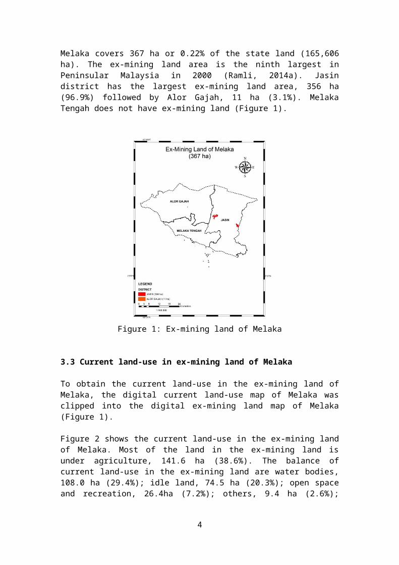
Figure 2: Current land-use in ex-mining land of Melaka
Geospatial analysis shows that there are 74.5 ha of idle ex-mining land, which has the potential to be developed, in Melaka. Jasin has 4 areas of idle ex-mining land with the largest extend, namely 72.6 ha (97.5%). This is followed by Alor Gajah that has 2 areas of idle ex-mining land with an area of 1.9 ha (2.5%), as shown in Table 1 and Figure 3.
Table 1: Idle ex-mining land of Melaka
No. District AreaHectare
(ha) (%)
1 Alor Gajah1 1.7 2.32 0.2 0.3
2 Jasin
3 1.2 1.64 0.2 0.25 6.3 8.56 64.9 87.1
Total 74.5 100.0
4
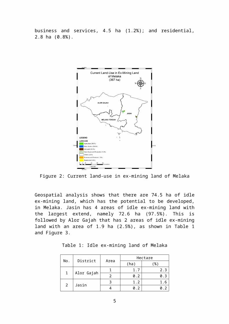
Figure 3: Idle ex-mining land of Melaka
3.4 Lithology of Melaka
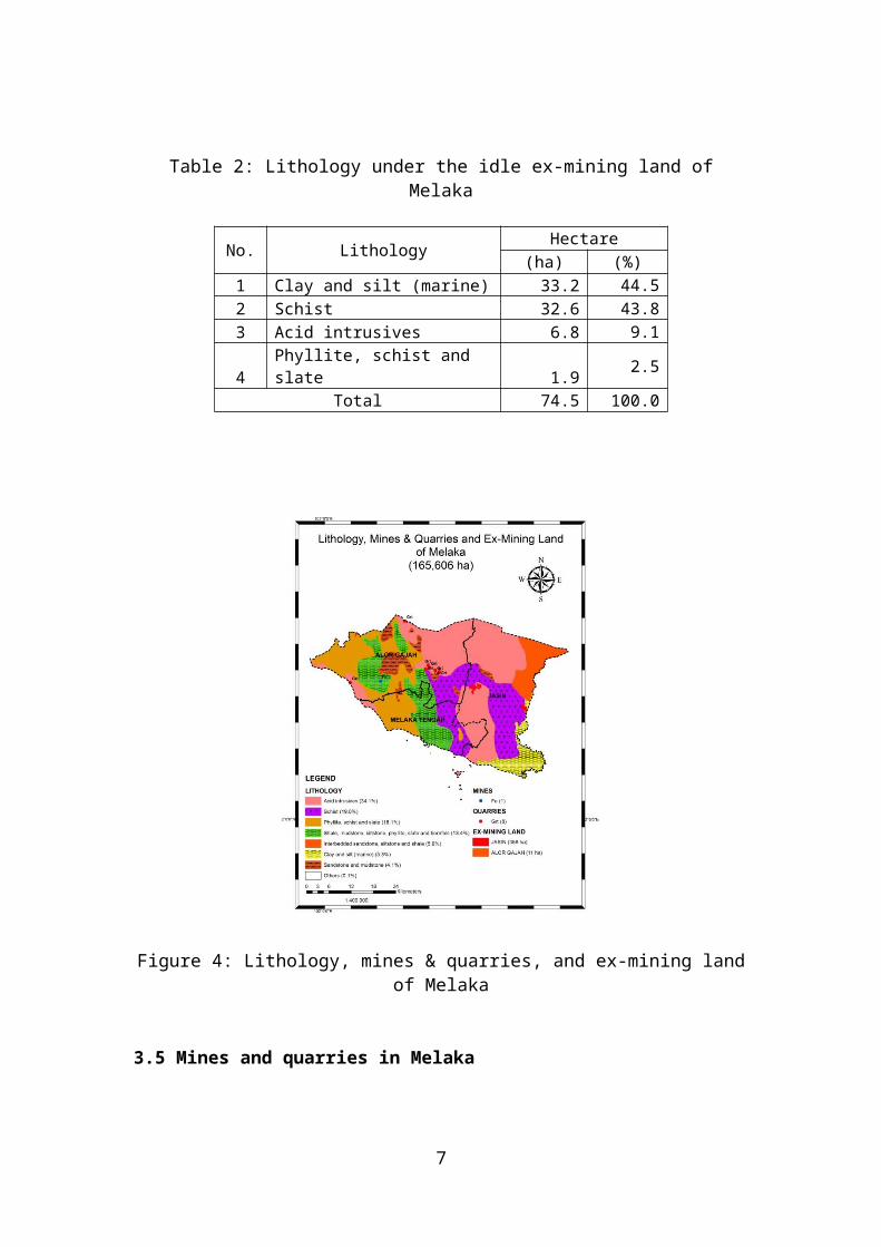
Geospatial analysis shows that most of the lithology of Melaka is acid intrusives, 56,415 ha (34.1%) followed by schist, 31,428 ha (19.0%); phyllite, schist and slate, 29,999 ha (18.1%); shale, mudstone, siltstone, phyllite, slate and hornfels, 22,112 ha (13.4%); interbedded sandstone, siltstone and shale, 9,831 ha (5.9%); clay and silt (marine), 8,853 ha (5.3%); sandstone and mudstone, 6,775 ha (4.1%); and others, 193 ha (0.1%) as shown in Figure 4.
Geospatial analysis also shows that most of the lithology under the idle ex-mining land in Melaka is clay and silt (marine), 33.2 ha (44.5%); schist, 32.6 ha (43.8%); acid intrusives, 6.8 ha (9.1%); and phyllite, schist and slate, 1.9 ha (2.5%) as shown in Table 2.
Table 2: Lithology under the idle ex-mining land of Melaka
No. LithologyHectare
(ha) (%)1 Clay and silt (marine) 33.2 44.52 Schist 32.6 43.83 Acid intrusives 6.8 9.14 Phyllite, schist and slate 1.9 2.5
Total 74.5 100.0
5
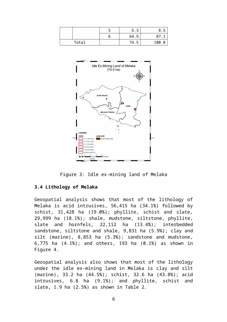
Figure 4: Lithology, mines & quarries, and ex-mining land of Melaka
3.5 Mines and quarries in Melaka
Mine statistics show that there were 2 iron ore mines in Melaka (Malaysia MGD, 2012a). However, mine digital map of Melaka, obtained from JMG Malaysia only shows 1 iron ore mine in Alor Gajah (Figure 4). There were no re-mining activities in the ex-mining land of Melaka.
Quarry statistics show that there were 9 granite quarries in Melaka (Malaysia MGD, 2012b). This is not surprising because most of lithology in Melaka is acid intrusives rocks (34.1%), i.e. granite. However, quarry digital map of Melaka, obtained from JMG Malaysia, shows that there were 8 granite quarries, all of which were located in Alor Gajah (Figure 4). There were no quarries operating subsurface in the ex-mining land of Melaka.
3.6 Metallic mineral and industrial mineral resources of Melaka
Geospatial analysis shows that there are 5 locations of aluminium resource (Al), 4 locations of tin resource (Sn), 2 locations of gold resource (Au), and 1 location of manganese resource (Mn) in Melaka (Figure 5). All 5 aluminium resources are located in Melaka Tengah. Three tin resources are located in Jasin and 1 tin resource is located in Alor Gajah. Both gold resources are in Jasin and the only manganese resource is located in Alor Gajah.
6
Geospatial analysis also shows that there are 3 locations of clay resource (Clay) in Melaka. Two clay resources are located in Melaka Tengah and the other is located in Alor Gajah (Figure 5).
Both metallic mineral and industrial mineral resources are not found in the ex-mining land of Melaka (Figure 5).
Figure 5: Metallic mineral and industrial mineral resources, and ex-mining land of Melaka
4.0 PROPOSED DEVELOPMENT OF IDLE EX-MINING LAND OF MELAKA
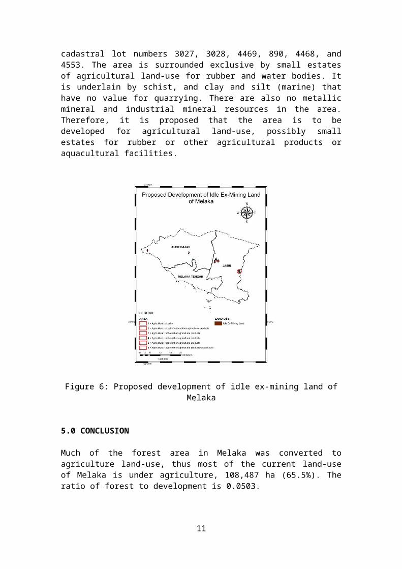
Subsection 3.3 shows that there are 6 idle ex-mining land areas in Melaka. The proposal to develop these areas are as follows (Figure 6):
Area 1 in Alor Gajah district, is a piece of idle ex-mining land of 1.7 ha that has not been cultivated forming part of cadastral lot numbers 770, 1399, and 1400. It is surrounded by oil palm agricultural land-use. The area is underlain by interbedded sandstone, siltstone and shale that has no quarrying value. There are also no metallic mineral and industrial mineral resources in the area. Therefore, it is proposed that the area is to be developed as oil palm agricultural land-use.
Area 2 in Alor Gajah district, is a piece of idle ex-mining land of 0.2 ha that has not been developed with no cadastral lot numbers. It is surrounded by small estates of oil palm, rubber, and other agricultural products land-use. The area is underlain by phyllite, schist and slate that has no quarrying value. There are also no metallic
7
mineral and industrial mineral resources in the area. Therefore, it is proposed that the area is to be developed as oil palm or rubber or other agricultural products land-use.
A piece of idle ex-mining land in Area 3 in Jasin district, covering 1.2 ha with cadastral lot numbers 1154 and 6691, is surrounded by small estates of rubber and other agricultural products land-use. The area is underlain by schist and acid intrusives rocks that have no quarrying values. There are also no metallic mineral and industrial mineral resources in the area. Therefore, it is proposed that the area is to be developed for agricultural land-use, possibly for small estates of rubber or other agricultural products.
Area 4 in Jasin district, covering 0.2 ha is a small piece of idle ex-mining land forming part of cadastral lot number 3270, is surrounded by small estates of agricultural land-use for rubber. The area is underlain by schist that has no value for quarrying. There are also no metallic mineral and industrial mineral resources in the area. Therefore, it is proposed that the area is to be developed for agricultural land-use, possibly a small estate for rubber or other agricultural products.
Area 5 in Jasin district, is a cluster of idle ex-mining land covering 6.3 ha listed as uncultivated agricultural land. It is part of cadastral lot numbers 742, 726, 722, 1292, 3193, 710, 709, and 708. The area, in most parts, is surrounded by agricultural land-use for rubber. It is exclusively underlain by acid intrusives rocks that have no quarrying values. There are also no metallic mineral and industrial mineral resources in the area. Therefore, it is proposed that the area is to be developed for agricultural land-use, possibly small estates for rubber or other agricultural products.
Area 6 in Jasin district, is a cluster of undeveloped idle ex-mining land covering 64.9 ha. It is part of cadastral lot numbers 3027, 3028, 4469, 890, 4468, and 4553. The area is surrounded exclusive by small estates of agricultural land-use for rubber and water bodies. It is underlain by schist, and clay and silt (marine) that have no value for quarrying. There are also no metallic mineral and industrial mineral resources in the area. Therefore, it is proposed that the area is to be developed for agricultural land-use, possibly small estates for rubber or other agricultural products or aquacultural facilities.
8

Figure 6: Proposed development of idle ex-mining land of Melaka
5.0 CONCLUSION
Much of the forest area in Melaka was converted to agriculture land-use, thus most of the current land-use of Melaka is under agriculture, 108,487 ha (65.5%). The ratio of forest to development is 0.0503.
The largest area of ex-mining land in Melaka was in 1975, i.e. 761 ha. However, the ex-mining land has been developed and digital data obtained from DOA in 2000 shows that the total ex-mining land area in Melaka covers 367 ha or 0.22% of the state land (165,606 ha). The ex-mining land area is the ninth largest in Peninsular Malaysia in 2000. Jasin district has the largest ex-mining land area, 356 ha (96.9%) followed by Alor Gajah, 11 ha (3.1%). Melaka Tengah does not have ex-mining land.
Most of the ex-mining land is under agriculture, 141.6 ha (38.6%). The balance of current land-use in the ex-mining land are water bodies, 108.0 ha (29.4%); idle land, 74.5 ha (20.3%); and others.
Geospatial analysis shows that most of the lithology of Melaka is acid intrusives, 56,415 ha (34.1%) followed by schist, 31,428 ha (19.0%); phyllite, schist and slate, 29,999 ha (18.1%); shale, mudstone, siltstone, phyllite, slate and hornfels, 22,112 ha (13.4%); and others.
Geospatial analysis also shows that most of the lithology under the idle ex-mining land in Melaka is clay and silt (marine), 33.2 ha (44.5%); schist, 32.6 ha (43.8%); and others.
9
Mine digital map of Melaka, obtained from JMG Malaysia only shows 1 iron ore mine in Alor Gajah. There were no re-mining activities in the ex-mining land of Melaka.
Quarry digital map of Melaka, obtained from JMG Malaysia, shows that there were 8 granite quarries, all of which were located in Alor Gajah. There were no quarries operating subsurface in the ex-mining land of Melaka.
Distribution of metallic mineral resources digital data in Melaka shows there are 12 locations of metallic mineral resources in Melaka. There are no metallic mineral resources in the ex-mining land of Melaka.
Distribution of industrial mineral resources digital data in Melaka shows there are 3 locations of industrial mineral resources (all of which are clay) in Melaka. There are no industrial mineral resources in the ex-mining land of Melaka.
Geospatial analysis shows that there are 74.5 ha of idle ex-mining land, which has the potential to be developed, in Melaka. Jasin has 4 areas of idle ex-mining land with the largest total extend of 72.6 ha and this is followed by Alor Gajah that has 2 areas of idle ex-mining land with a total area of 1.9 ha. The areas that are proposed to be developed are as follows:
Area 1 in Alor Gajah district, covering an area of 1.7 ha, is proposed to be developed as agricultural land-use for oil palm.
Area 2 in Alor Gajah district, covering an area of 0.2 ha, is proposed to be developed as agricultural land-use for oil palm or rubber or other agricultural products.
Area 3 in Jasin district, covering an area of 1.2 ha, is proposed to be developed as agricultural land-use possibly for small estates of rubber or other agricultural products.
Area 4 in Jasin district, covering an area of 0.2 ha, is proposed to be developed as agricultural land-use possibly for a small estate for rubber or other agricultural products.
Area 5 in Jasin district, covering an area of 6.3 ha, is proposed to be developed as agricultural land-use possibly for small estates for rubber or other agricultural products.
Area 6 in Jasin district, covering an area of 64.9 ha, is proposed to be developed as agricultural land-use possibly for small estates for rubber or other agricultural products, or aquacultural facilities.
ACKNOWLEDGEMENT
The authors thank YBrs. Tn. Hj. Shahar Effendi Abdullah Azizi, Director of Mineral Research Centre, Ipoh for his support in carrying out the project and for granting permission to publish this paper. We also record our thanks to JPBD Melaka for providing current digital land-use map of Melaka, to DOA Malaysia for providing digital map of the ex-mining land of Melaka, and to JUPEM for providing digital cadastral data of Melaka.
10
REFERENCES
MGD Malaysia, 2012a. Malaysian Minerals Yearbook 2012, Minerals and Geoscience Department Malaysia.
MGD Malaysia, 2012b. Industrial Mineral Production Statistics and Directory of Producers in Malaysia 2012, Minerals and Geoscience Department Malaysia.
Ramli, M.O., Mohd Anuar, I., & Mohd Zulkiflee, C.S., 2011a. Idle ex-mining land of Perak 2011. Proceedings of SIMPOMIN 2011, 18-20 October 2011, Tower Regency Hotel Ipoh, Perak.
Ramli, M.O., Mustafar, H., & Mohd Anuar, I., 2011b. Spatial distribution of ex-mining ponds in Perak and Selangor using satellite images and ArcGIS. Proceedings of SIMPOMIN 2011, 18-20 October 2011, Tower Regency Hotel Ipoh, Perak.
Ramli, M.O., Noor Bakri, E., & Hamid, A., 2011c. Mapping of ex-mining land land-use of Malim Nawar-Ipoh area using Spot 5 satellite images. Proceedings of SIMPOMIN 2011, 18-20 October 2011, Tower Regency Hotel Ipoh, Perak.
Ramli, M.O. & Mohd Anuar, I., 2012a. Geospatial analysis of ex-mining land in Perak. Proceedings of National Geoscience Conference 2012, 23-24 June 2012, Pullman Hotel Kuching, Sarawak.
Ramli, M.O. & Mohd Anuar, I., 2012b. Land-use of ex-mining land in Perak. Proceedings of the International Symposium on Reclamation, Rehabilitation and Restoration towards a Greener Asia, 3-5 July 2012, Kuala Lumpur.
Ramli, M.O., 2013a. Kajian maklumat geospatial tanah bekas lombong negara RP2 (2012). No. Laporan: PPM R001/2013, Pusat Penyelidikan Mineral, Jabatan Mineral dan Geoscience Malaysia, Ipoh, Perak.
Ramli, M.O., 2013b. Rate of development of ex-mining land in Peninsular Malaysia. Proceedings of the National Geoscience Conference 2013, 8-9 June 2013, Kinta Riverfront Hotel & Suites, Ipoh.
Ramli, M.O., 2013c. Rate of development of ex-mining land in Peninsular Malaysia – Revised. Paper presented in Symposium Mineral 2013, 12– 13 November 2013, Kinta Riverfront Hotel, Ipoh, Perak.
Ramli, M.O. & Mohd Anuar, I., 2013. Geospatial analyses of ex-mining land in Perak 2013. Paper presented in Symposium Mineral 2013, 12– 13 November 2013, Kinta Riverfront Hotel, Ipoh, Perak.
Ramli, M.O., Mohd Anuar, I., & Ahmad Zukni, A.K., 2013. The need to practiced sub-surface limestone quarrying in Perak. Paper presented in Symposium Mineral 2013, 12– 13 November 2013, Kinta Riverfront Hotel, Ipoh, Perak.
Ramli, M.O., 2014a. Laporan Koleksi Data Taburan Tanah Bekas Lombong di Malaysia (1960 hingga 2008). No. Laporan: PPM R005/2014, Pusat Penyelidikan Mineral, Jabatan Mineral dan Geoscience Malaysia, Ipoh, Perak.
Ramli, M.O., 2014b. Laporan Analisis Geospatial Tanah Bekas Lombong di Negeri Johor. No. Laporan: PPM R006/2014, Pusat Penyelidikan Mineral, Jabatan Mineral dan Geoscience Malaysia, Ipoh, Perak.
Ramli, M.O., 2014c. Laporan Analisis Geospatial Tanah Bekas Lombong di Negeri Melaka. No. Laporan: PPM R007/2014, Pusat Penyelidikan Mineral, Jabatan Mineral dan Geoscience Malaysia, Ipoh, Perak.
Ramli, M.O., 2014d. Laporan Analisis Geospatial Tanah Bekas Lombong di Negeri Sembilan. No. Laporan: PPM R0011/2014, Pusat Penyelidikan Mineral, Jabatan Mineral dan Geoscience Malaysia, Ipoh, Perak.
11
Ramli, M.O., 2014e. Laporan Analisis Geospatial Tanah Bekas Lombong di Negeri Pahang. No. Laporan: PPM R0012/2014, Pusat Penyelidikan Mineral, Jabatan Mineral dan Geoscience Malaysia, Ipoh, Perak.
Ramli, M.O., 2014f. Laporan Analisis Geospatial Tanah Bekas Lombong di Negeri Terengganu. No. Laporan: PPM R0013/2014, Pusat Penyelidikan Mineral, Jabatan Mineral dan Geoscience Malaysia, Ipoh, Perak.
Ramli, M.O., 2014g. Laporan Analisis Geospatial Tanah Bekas Lombong di Negeri Kelantan. No. Laporan: PPM R0014/2014, Pusat Penyelidikan Mineral, Jabatan Mineral dan Geoscience Malaysia, Ipoh, Perak.
Ramli, M.O. & Meor Abdul Rahman, M.T., 2014. Estimation of sub-surface limestone resource under idle ex-mining land in Perak. Paper presented in National Geoscience Conference, 13-14 June 2014. Hotel Grand Continental, Kuala Terengganu, Terengganu, Malaysia.
Ramli, M.O. & Nor Azlin, A., 2014. Geospatial analyses of ex-mining land in Johor. Paper presented in National Geoscience Conference 2014, 13-14 June 2014. Hotel Grand Continental, Kuala Terengganu, Terengganu, Malaysia.
12