Embed Size (px)
Citation preview

Page 1 of 2 Project: 31.5 feet bgs Sampling Method: Split-Spoon Location: 8 inches with Hydraulic Hammer and Brass Sleeves Project No.: WDC Exploration Logged By:
Hollow-Stem Auger
Depth(feet bgs) Recovery
Blow Counts Time
Sample No. USCS
Graphic Log
OVA (ppm, BZ = breathing zone)
Surface: grass/topsoil.
Geology from boring SB1 SP-SM 0 to 5 feet bgs. POORLY GRADED SAND WITH SILT: (10 YR
5/4) yellowish brown, dry, poorly graded, 90% very loose,
subrounded, very fine to fine-grained sand, 10% nonplastic
fines, no odor or staining observed.
SM 5 to 6.5 feet bgs. SILTY SAND: (10 YR 6/4 to 2.5 Y 6/1) light
yellowish brown to gray, dry, poorly graded, 80% medium dense,
subrounded, very fine to fine-grained sand, 20% nonplastic fines,
trace friable cobbles (weathered San Timoteo SANDSTONE at
bottom of shoe), maximum size > 3 inches, no odor.
Sample collected in brass sleeves with 2 1/2 inch split-spoon sampler
using hydraulic hammer for geotechnical testing.7 1230 SB1-10-10. SM/SC 10 to 11.5 feet bgs. SILTY/CLAYEY SAND: (10 YR 5/4 - 8/2)
9 SB1-10.5-11' yellowish brown to very pale brown, dry, poorly graded, 70%
9 loose to medium dense, subrounded, very fine to fine-grained sand,30% fines with no to low plasticity, trace hard, fine gravel,
maximum size = 3/8 inches, no odor.
SM 15 to 18 feet bgs. SILTY SAND: (10 YR 6/4) light yellowish
brown, dry, poorly graded, 80% dense, subrounded, very fine to
medium-grained sand, 20% nonplastic fines, no odor.
Transition zone at 18 feet bgs. Weathered San Timoteo formation
redeposited as alluvium. Sample SB1-18' collected above contact.
SM 18 to 25.5 feet bgs. SILTY SAND: (10 YR 5/4 to 2.5 Y 6/3)
yellowish brown to light yellowish brown, dry, poorly graded,
70% dense to very dense, subrounded, very fine to fine-grained
sand, 30% nonplastic fines, no odor.
LMC Beaumont Site 2
Date Boring Started: Date Boring Completed: 31-Oct-2007
31-Oct-2007David Bertolacci19892-03Former Discharge Ponds
---- 19 ----
---- 18 ----
---- 10 ----
---- 11 ----
---- 12 ----
---- 13 ----
---- 14 ----
---- 15 ----
---- 16 ----
---- 17 ----
---- 6 ----
---- 7 ----
---- 8 ----
---- 9 ----
---- 2 ----
---- 3 ----
---- 4 ----
---- 5 ----
BORING LOGBoring ID: SB1B
---- 0 ----
---- 1 ----
Borehole Depth: Borehole Diameter: Drilling Contractor:
Drilling Method:
Interval and Lithologic Description
Northing (feet): Easting (feet): Ground Surface Elevation (feet MSL): Top of Casing Elevation (feet MSL):
100%
---- 20 ----

Page 2 of 2 Project: 31.5 feet bgs Sampling Method: Split-Spoon Location: 8 inches with Hydraulic Hammer and Brass Sleeves Project No.: WDC Exploration Logged By:
Hollow-Stem Auger
Depth(feet bgs) Recovery
Blow Counts Time
Sample No. USCS
Graphic Log
OVA (ppm, BZ = breathing zone)
LMC Beaumont Site 2
Date Boring Started: Date Boring Completed: 31-Oct-2007
31-Oct-2007David Bertolacci19892-03Former Discharge Ponds
BORING LOGBoring ID: SB1B
Borehole Depth: Borehole Diameter: Drilling Contractor:
Drilling Method:
Interval and Lithologic Description
Northing (feet): Easting (feet): Ground Surface Elevation (feet MSL): Top of Casing Elevation (feet MSL):
SM SILTY SAND: As above.
Weathered San Timoteo contact at 25.5 feet bgs.
ss/slst 25.5 to 30 feet bgs. SANDSTONE WITH SILTSTONE/CLAYSTONE:
(SP-SM/SC) (2.5 Y 6/2) light brownish gray, dry, poorly graded, friable, 90% very
dense, subrounded, very fine to fine-grained sand, 10% very stiff,
fines with no to low plasticity, no odor, weak cementation, interbedded
SANDSTONE and SILTSTONE layering.
100 1320 SB1-30 - 30.5' 30 to 31.5 feet bgs. SANDSTONE WITH SILTSTONE/CLAYSTONE: As above.
200 SB1-30.5 - 31' Sample collected in brass sleeves with 2 1/2 inch split-spoon sampler using hydraulic hammer for geotechnical testing.
Total Depth = 31.5 feet bgs.
Geotechnical samples collected on 31-Oct 2007 via hydraulic hammer
Borehole backfilled with Portland Type II/V cement and Volclay
Grout slurry from bottom up using tremie pipe.
---- 20 ----
---- 28 ----
---- 29 ----
---- 21 ----
---- 26 ----
---- 27 ----
---- 24 ----
---- 25 ----
---- 22 ----
---- 23 ----
---- 32 ----
---- 33 ----
---- 30 ----
---- 31 ----
100%
---- 40 ----
---- 38 ----
---- 39 ----
---- 36 ----
---- 37 ----
---- 34 ----
---- 35 ----

Page 1 of 4 Project: 70 feet bgs Sampling Method: Split-Spoon Location: 10 inches Project No.: WDC Exploration Logged By:
Hollow-Stem Auger
Depth(feet bgs) Recovery
Blow Counts Time
Sample No. USCS
Graphic Log
OVA (ppm, BZ = breathing zone)
Surface: grass/topsoil.
5 SM 0 to 1.5 feet bgs. SILTY SAND: (10 YR 6/4) light yellowish
5 1448 SB4-0.5' brown, dry, poorly graded, 80% loose, subrounded, very fine
5 to fine-grained sand, 20% nonplastic fines, trace hard, subangular,
fine gravel, maximum size = 3/8 inch, no staining or odor.
5 1452 SB4-5' SM/SC 5 to 6.5 feet bgs. SILTY/CLAYEY SAND: (10 YR 5/4) yellowish
7 1453 SB4-5'-DUP brown, dry, poorly graded, 80% loose, subrounded, very fine to
9 fine-grained sand, 20% fines with no to low plasticity, trace friable
to hard, subangular, fine to coarse gravel, maximum size = 3/4 inch,
no odor.
9 1500 SB4-10' SM 10 to 13 feet bgs. SILTY SAND: (10 YR 5/4) yellowish brown,
11 damp, poorly graded, 80% loose, subrounded, very fine to coarse-
13 grained sand, 20% nonplastic fines, trace friable to hard, subangular,15 coarse gravel, maximum size = 2 inches, no odor, granitic mineralogy.
20 Increasing coarse sand at 10 feet bgs, gravel zone at 11.5 feet bgs.
20 Weathered San Timoteo formation contact at 13 feet bgs.
12 ss 13 to 15 feet bgs. SANDSTONE WITH SILT: (2.5 Y 6/2) light
14 brownish gray, dry, poorly graded, 90% medium dense,
16 subrounded, very fine to fine-grained sand, 10% nonplastic
20 fines, no odor.
25 1508 SB4-15' slst 15 to 16 feet bgs. SILTSTONE: (2.5 Y 5/2) grayish brown, damp,
25 poorly graded, 50% medium dense to dense, subrounded, very
fine to fine-grained sand, 50% nonplastic fines, no odor, weak
cementation, weathered San Timoteo Formation.
100%
100%
100%
100%
100%
100%
---- 20 ----
Northing (feet): Easting (feet): Ground Surface Elevation (feet MSL): Top of Casing Elevation (feet MSL):
BORING LOGBoring ID: SB4
---- 0 ----
---- 1 ----
Borehole Depth: Borehole Diameter: Drilling Contractor:
Drilling Method:
Interval and Lithologic Description
---- 2 ----
---- 3 ----
---- 4 ----
---- 5 ----
---- 6 ----
---- 7 ----
---- 8 ----
---- 9 ----
---- 10 ----
---- 11 ----
---- 12 ----
---- 13 ----
---- 19 ----
---- 14 ----
---- 15 ----
---- 16 ----
---- 17 ----
---- 18 ----
LMC Beaumont Site 2
Date Boring Started: Date Boring Completed: 30-Oct-2007
25-Oct-2007David Bertolacci19892-03Former Discharge Ponds

Page 2 of 4 Project: 70 feet bgs Sampling Method: Split-Spoon Location: 10 inches Project No.: WDC Exploration Logged By:
Hollow-Stem Auger
Depth(feet bgs) Recovery
Blow Counts Time
Sample No. USCS
Graphic Log
OVA (ppm, BZ = breathing zone)
Northing (feet): Easting (feet): Ground Surface Elevation (feet MSL): Top of Casing Elevation (feet MSL):
BORING LOGBoring ID: SB4
Borehole Depth: Borehole Diameter: Drilling Contractor:
Drilling Method:
Interval and Lithologic Description
LMC Beaumont Site 2
Date Boring Started: Date Boring Completed: 30-Oct-2007
25-Oct-2007David Bertolacci19892-03Former Discharge Ponds
43 1518 SB4-20' slst 20 to 21.5 feet bgs. SANDSTONE/SILTSTONE: (2.5 Y 5/2)
50 grayish brown, damp, poorly graded, 50% dense to very dense,
subrounded, very fine to fine-grained sand, 50% nonplastic fines,
no odor, weak cementation.
35 1523 SB4-25' slst 25 to 26.5 feet bgs. SANDSTONE/SILTSTONE: (2.5 Y 5/2)
50 grayish brown, damp, poorly graded, 50% dense to very dense,
subrounded, very fine to fine-grained sand, 50% nonplastic fines,
no odor, weak cementation.
33% 75/6" 1530 SB4-30' ss 30 to 31.5 feet bgs. SANDSTONE: (2.5 Y 6/4) light yellowish
brown, dry to damp, poorly graded, 95% very dense,
subrounded, very fine to fine-grained sand, 5% nonplastic
fines, no odor, weak cementation, platy bedding layers.
33% 80/6" 1537 SB4-35' ss/slst 35 to 36.5 feet bgs. SANDSTONE WITH SILT: (2.5 Y 6/4) light
yellowish brown, dry to damp, poorly graded, 90% very dense,
subrounded, very fine to fine-grained sand, 10% nonplastic
fines, no odor, weak cementation, platy bedding layers.
Increasing fines.
50%
100%
---- 40 ----
---- 32 ----
---- 33 ----
---- 30 ----
---- 31 ----
---- 36 ----
---- 37 ----
---- 34 ----
---- 35 ----
---- 38 ----
---- 39 ----
---- 28 ----
---- 29 ----
---- 21 ----
---- 26 ----
---- 27 ----
---- 24 ----
---- 25 ----
---- 22 ----
---- 23 ----
---- 20 ----

Page 3 of 4 Project: 70 feet bgs Sampling Method: Split-Spoon Location: 10 inches Project No.: WDC Exploration Logged By:
Hollow-Stem Auger
Depth(feet bgs) Recovery
Blow Counts Time
Sample No. USCS
Graphic Log
OVA (ppm, BZ = breathing zone)
Northing (feet): Easting (feet): Ground Surface Elevation (feet MSL): Top of Casing Elevation (feet MSL):
BORING LOGBoring ID: SB4
Borehole Depth: Borehole Diameter: Drilling Contractor:
Drilling Method:
Interval and Lithologic Description
LMC Beaumont Site 2
Date Boring Started: Date Boring Completed: 30-Oct-2007
25-Oct-2007David Bertolacci19892-03Former Discharge Ponds
33% 80/6" 1548 SB4-40' ss 40 to 40.5 feet bgs. SANDSTONE: (2.5 Y 6/4) light
yellowish brown, moist, poorly graded, 95% very dense,
subrounded, very fine to fine-grained sand, 5% nonplastic
fines, no odor, weak cementation, platy bedding layers.
Decreasing fines.
33% 80/6" 1600 SB4-45' ss/slst 45 to 45.5 feet bgs. SANDSTONE WITH SILT: (2.5 Y 6/4) light
yellowish brown, moist, poorly graded, 90% very dense,
subrounded, very fine to fine-grained sand, 10% nonplastic
fines, no odor, weak cementation, platy bedding layers.
Increasing fines.
* Hole dry at 50 feet bgs. On 26-Oct 2007, left open, moist soil in
bottom of hole at 48.6 feet bgs on 29-Oct 2007, no freestanding
water for sampling, instruct drillers to drill to 55 feet bgs.15% 80/4" 1602 SB4-50' ss/slst 50 to 50.5 feet bgs. SILTY SANDSTONE: (2.5 Y 5/3) light
olive brown, moist, poorly graded, 80% very dense,
subrounded, very fine to fine-grained sand, 20% nonplastic
fines, no odor, weak cementation, platy bedding layers.
Increasing fines.
* Continue drilling on 30-Oct 2007.
25 1610 SB4-55' ss/slst 55 to 56.5 feet bgs. SILTY SANDSTONE: (2.5 Y 5/3) light
50 30-Oct-2007 olive brown, dry to damp, poorly graded, 80% medium dense to
very dense, subrounded, very fine to fine-grained sand, 20%
nonplastic fines, no odor, weak cementation, platy bedding layers.
67%
---- 49 ----
---- 50 ----
---- 47 ----
---- 60 ----
---- 55 ----
---- 56 ----
---- 54 ----
---- 51 ----
---- 52 ----
---- 53 ----
---- 59 ----
---- 57 ----
---- 58 ----
---- 48 ----
---- 45 ----
---- 46 ----
---- 43 ----
---- 44 ----
---- 41 ----
---- 42 ----
---- 40 ----

Page 4 of 4 Project: 70 feet bgs Sampling Method: Split-Spoon Location: 10 inches Project No.: WDC Exploration Logged By:
Hollow-Stem Auger
Depth(feet bgs) Recovery
Blow Counts Time
Sample No. USCS
Graphic Log
OVA (ppm, BZ = breathing zone)
Northing (feet): Easting (feet): Ground Surface Elevation (feet MSL): Top of Casing Elevation (feet MSL):
BORING LOGBoring ID: SB4
Borehole Depth: Borehole Diameter: Drilling Contractor:
Drilling Method:
Interval and Lithologic Description
LMC Beaumont Site 2
Date Boring Started: Date Boring Completed: 30-Oct-2007
25-Oct-2007David Bertolacci19892-03Former Discharge Ponds
30 1620 SB4-60' ss/slst 60 to 61 feet bgs. SILTY SANDSTONE: (2.5 Y 6/4 to 5/2) light
50 1625 SB4-60'-DUP yellowish brown to grayish brown, dry to damp, poorly graded,
ss 80% dense to very dense, subrounded, very fine to fine-grained
sand, 20% nonplastic fines, no odor, weak cementation, platy
bedding layers; at 61 feet bgs. grayish brown SANDSTONE,
decreasing fines, micaceous, increasing sand grain size.
15% 100/6" 1627 SB4-65' ss 65 to 65.5 feet bgs. SANDSTONE: (2.5 Y 5/2) grayish brown,
moist, poorly graded, 100% very dense, subrounded, fine to
0916 SB4-66' medium-grained sand, trace nonplastic fines, no odor, weak
(Water sample collected 31-Oct-2007) cementation.
1st water at approximately 66 feet bgs (measured in open borehole
on 31-Oct 2007 at 0800).
* Running sand noted in cuttings between 65 and 70 feet bgs.
70 to 70.5 feet bgs. SANDSTONE: (2.5 Y 5/2) grayish brown,
wet, poorly graded, 100% very dense, subrounded, fine to
medium-grained sand, trace nonplastic fines, no odor, weak 15% 100/6" 1636 SB4-70' ss cementation, high degree of weathering.
Total Depth = 70 feet bgs.
Borehole left open to let water accumulate, water samplecollected on 31-Oct 2007 via bailer and borehole backfilled
with Portland Type II/V cement and Volclay Grout slurry using
tremie pipe from bottom of borehole.
67%---- 60 ----
---- 80 ----
---- 77 ----
---- 78 ----
---- 79 ----
---- 73 ----
---- 74 ----
---- 75 ----
---- 76 ----
---- 69 ----
---- 70 ----
---- 71 ----
---- 72 ----
---- 65 ----
---- 66 ----
---- 67 ----
---- 68 ----
---- 61 ----
---- 62 ----
---- 63 ----
---- 64 ----

Page 1 of 1 Project: 17 feet bgs Sampling Method: Split-Spoon Location: 8 inches Project No.: WDC Exploration Logged By:
Hollow-Stem Auger
Depth(feet bgs) Recovery
Blow Counts Time
Sample No. USCS
Graphic Log
OVA (ppm, BZ = breathing zone)
Surface: grass/topsoil.
Geology from boring SB4 SM 0 to 1.5 feet bgs. SILTY SAND: (10 YR 6/4) light yellowish
brown, dry, poorly graded, 80% loose, subrounded, very fine
to fine-grained sand, 20% nonplastic fines, trace hard, subangular,
fine gravel, maximum size = 3/8 inch, no staining or odor.
5 1450 SB4-5-5.5' SM/SC 5 to 6.5 feet bgs. SILTY/CLAYEY SAND: (10 YR 5/4) yellowish
5 SB4-5.5-6' brown, dry, poorly graded, 80% loose, subrounded, very fine to
7 fine-grained sand, 20% fines with no to low plasticity, trace friable
to hard, subangular, fine to coarse gravel, maximum size = 3/4 inch,
no odor.
SM 10 to 13 feet bgs. SILTY SAND: (10 YR 5/4) yellowish brown,
damp, poorly graded, 80% loose, subrounded, very fine to coarse-
grained sand, 20% nonplastic fines, trace friable to hard, subangular,coarse gravel, maximum size = 2 inches, no odor, granitic mineralogy.
Increasing coarse sand at 10 feet bgs, gravel zone at 11.5 feet bgs.
Weathered San Timoteo formation contact at 13 feet bgs.
ss 13 to 15 feet bgs. SANDSTONE WITH SILT: (2.5 Y 6/2) light
brownish gray, dry, poorly graded, 90% medium dense,
subrounded, very fine to fine-grained sand, 10% nonplastic
fines, no odor.0% Slough at 15 feet bgs. slst 15 to 17 feet bgs. SILTSTONE: (2.5 Y 5/2) grayish brown, damp,
>100 1500 SB4-15.5-16' poorly graded, 50% medium dense to dense, subrounded, very
SB4-16-16.5' fine to fine-grained sand, 50% nonplastic fines, no odor, weakcementation, weathered San Timoteo Formation.
Total Depth = 17 feet bgs.
Geotechnical samples collected on 31-Oct 2007 via hydraulic hammer
and borehole backfilled with Portland Type II/V cement and Volclay
Grout slurry using tremie pipe from bottom of borehole.
LMC Beaumont Site 2
Date Boring Started: Date Boring Completed: 31-Oct-2007
31-Oct-2007David Bertolacci19892-03Former Discharge Ponds
---- 11 ----
---- 12 ----
---- 13 ----
---- 19 ----
---- 14 ----
---- 15 ----
---- 16 ----
---- 17 ----
---- 18 ----
---- 7 ----
---- 8 ----
---- 9 ----
---- 10 ----
Top of Casing Elevation (feet MSL):
BORING LOGBoring ID: SB4B
---- 0 ----
Borehole Depth: Borehole Diameter: Drilling Contractor:
Drilling Method:
Interval and Lithologic Description
Northing (feet): Easting (feet): Ground Surface Elevation (feet MSL):
100%
100%
---- 20 ----
---- 1 ----
---- 2 ----
---- 3 ----
---- 4 ----
---- 5 ----
---- 6 ----

Page 1 of 4 Project: 60 feet bgs Sampling Method: Split-Spoon Location: 8 inches Project No.: WDC Exploration Logged By:
Hollow-Stem Auger
Depth(feet bgs) Recovery
Blow Counts Time
Sample No. USCS
Graphic Log
OVA (ppm, BZ = breathing zone)
Surface: grass/topsoil.
10 SM 0 to 1.5 feet bgs. SILTY SAND: (10 YR 5/3) brown, dry,
10 1233 SB5-0.5' poorly graded, 80% loose, subrounded, very fine to fine-grained
8 sand, 20% nonplastic fines, trace friable to hard, subangular,
fine gravel, maximum size = 1/4 to 3/8 inch, no staining or odor.
5 1240 SB5-5' SM 5 to 6.5 feet bgs. SILTY SAND: (10 YR 5/4) yellowish brown,
5 dry, poorly graded, 75% loose, subrounded, very fine to fine-
7 grained sand, 15% nonplastic fines, trace hard, subangular,
fine gravel, maximum size = 1/4 to 3/8 inch, no staining or odor.
7 1243 SB5-10' SM 10 to 11.5 feet bgs. SILTY SAND: (10 YR 5/4) yellowish brown,
7 dry, poorly graded, 80% loose, subrounded, very fine to fine-
7 grained sand, 20% nonplastic fines, trace friable, subangular,fine gravel, maximum size = 1/4 inch, no staining or odor.
7 1245 SB5-15' SM 15 to 16.5 feet bgs. SILTY SAND: (10 YR 6/4) light yellowish
9 brown, dry, poorly graded, 85% loose to medium dense,
11 subrounded, very fine to medium-grained sand, 15% nonplastic
fines, no odor.
LMC Beaumont Site 2
Date Boring Started: Date Boring Completed: 29-Oct-2007
25-Oct-2007
---- 19 ----
---- 14 ----
---- 15 ----
---- 16 ----
---- 9 ----
---- 17 ----
---- 18 ----
---- 12 ----
---- 13 ----
BORING LOGBoring ID: SB5
---- 0 ----
---- 1 ----
Borehole Depth: Borehole Diameter:
David Bertolacci19892-03Former Discharge Ponds
---- 2 ----
---- 3 ----
---- 4 ----
---- 5 ----
---- 11 ----
Easting (feet): Ground Surface Elevation (feet MSL): Top of Casing Elevation (feet MSL):
---- 20 ----
Drilling Contractor:
Drilling Method:
Interval and Lithologic Description
---- 10 ----
---- 6 ----
---- 7 ----
---- 8 ----
Northing (feet):
100%
100%
50%
100%

Page 2 of 4 Project: 60 feet bgs Sampling Method: Split-Spoon Location: 8 inches Project No.: WDC Exploration Logged By:
Hollow-Stem Auger
Depth(feet bgs) Recovery
Blow Counts Time
Sample No. USCS
Graphic Log
OVA (ppm, BZ = breathing zone)
LMC Beaumont Site 2
Date Boring Started: Date Boring Completed: 29-Oct-2007
25-Oct-2007
BORING LOGBoring ID: SB5
Borehole Depth: Borehole Diameter:
David Bertolacci19892-03Former Discharge Ponds
Easting (feet): Ground Surface Elevation (feet MSL): Top of Casing Elevation (feet MSL):
Drilling Contractor:
Drilling Method:
Interval and Lithologic Description
Northing (feet):
15 1249 SB5-20' SP-SM 20 to 27.5 feet bgs. POORLY GRADED SAND WITH SILT:
15 (10 YR 6/4 to 5/4) light yellowish brown to yellowish brown,
20 dry to damp, poorly graded, 90% medium dense, subrounded,
12 very fine to medium-grained sand, 10% nonplastic fines, trace
13 friable to hard, subrounded to subangular, fine gravel, maximum
15 size = 1/2 inch, no odor.
14
16
18
16
18 1255 SB5-25' SP-SM POORLY GRADED SAND WITH SILT: As above.
22
18 Fine-grained sand stringer, followed by increasing gravel (5-10%)
23 and coarse-grained sand from 26 to 27 feet bgs.
25 SP-SC 27 to 30.5 feet bgs. POORLY GRADED SAND WITH CLAY:
12 As above, increasing fines with low plasticity at 27.5 feet bgs.
12
20
17
19 Sampled directly above contact Increasing gravel at 30 feet bgs.21 1315 SB5-30' Weathered San Timoteo Formation contact at 30.5 feet bgs.
20 ss 30.5 to 33.5 feet bgs. SANDSTONE: (2.5 Y 6/3) light yellowish
23 ss/slst brown, damp, poorly graded, 95% dense, subrounded, very fine to
25 fine-grained sand, 5% nonplastic fines, no odor; weak cementation,
45 increasing silt and clay nodules at 31 feet bgs (to 25%); interbedded
50 SANDSTONE and SILTSTONE through 33.5 feet bgs.
40 1339 SB5-35' ss 35 to 36.5 feet bgs. SANDSTONE: (2.5 Y 6/2) light brownish gray,
50 damp to moist, poorly graded, 100% dense to very dense,
subrounded, very fine to fine-grained sand, no odor, weak
cementation, augers grinding at approximately 35 feet bgs and
cuttings steaming.
---- 20 ----
---- 21 ----
---- 26 ----
100%
100%
---- 27 ----
---- 24 ----
---- 25 ----
---- 22 ----
---- 23 ----
---- 30 ----
---- 31 ----
---- 28 ----
---- 29 ----
---- 34 ----
---- 35 ----
---- 32 ----
---- 33 ----
---- 38 ----
---- 39 ----
---- 36 ----
---- 37 ----
---- 40 ----
100%
100%
67%
67%
100%
100%
100%
100%

Page 3 of 4 Project: 60 feet bgs Sampling Method: Split-Spoon Location: 8 inches Project No.: WDC Exploration Logged By:
Hollow-Stem Auger
Depth(feet bgs) Recovery
Blow Counts Time
Sample No. USCS
Graphic Log
OVA (ppm, BZ = breathing zone)
LMC Beaumont Site 2
Date Boring Started: Date Boring Completed: 29-Oct-2007
25-Oct-2007
BORING LOGBoring ID: SB5
Borehole Depth: Borehole Diameter:
David Bertolacci19892-03Former Discharge Ponds
Easting (feet): Ground Surface Elevation (feet MSL): Top of Casing Elevation (feet MSL):
Drilling Contractor:
Drilling Method:
Interval and Lithologic Description
Northing (feet):
43 1349 SB5-40' ss/slst 40 to 41.5 feet bgs. SILTY SANDSTONE: (2.5 Y 6/2 to 4/2)
50 light to dark brownish gray, damp to moist, poorly graded, 80%
very dense, subrounded, very fine to fine-grained sand, 20%
nonplastic fines, weak cementation, no odor, color change to dark
brownish gray at 41 feet bgs.
* Augers grinding from 45 to 50 feet bgs.
40 1400 SB5-45' ss/slst 45 to 46.5 feet bgs. SANDSTONE WITH SILT: (2.5 Y 6/2 to 4/2)
50 +MS/MSD light to dark brownish gray, damp to moist, poorly graded, 90%
very dense, subrounded, very fine to fine-grained sand, 10%
nonplastic fines, weak cementation, no odor, decreasing fines.
15% 80/3" 1400 SB5-50' ss/slst 50 to 50.5 feet bgs. SANDSTONE WITH SILT: (2.5 Y 6/2 to 4/2)
light to dark brownish gray, damp, poorly graded, 90%
very dense, subrounded, very fine to fine-grained sand, 10%
nonplastic fines, weak cementation, no odor.
* Stop drilling at 50 feet bgs to let water accumulate on 10/25/2007,
hole dry on 10/26/2007 and 10/29/2007, resume drilling 10/29/2007.
45 1015 SB5-55' ss 55 to 56.5 feet bgs. SANDSTONE: (2.5 Y 6/3) light yellowish
50 10/29/2007 brown, damp, poorly graded, 100% very dense, subrounded, very
fine to fine-grained sand, weak cementation, no odor.
45 0800 SB5-58' (water) 1st water at 58.42 feet bgs on 10/30/2007.
50 10/30/2007
67%
100%
50%
---- 43 ----
---- 44 ----
---- 41 ----
---- 42 ----
---- 40 ----
---- 47 ----
---- 48 ----
---- 45 ----
---- 46 ----
---- 54 ----
---- 51 ----
---- 52 ----
---- 49 ----
---- 50 ----
---- 57 ----
---- 58 ----
---- 60 ----
---- 59 ----
---- 55 ----
---- 56 ----
---- 53 ----

Page 4 of 4 Project: 60 feet bgs Sampling Method: Split-Spoon Location: 8 inches Project No.: WDC Exploration Logged By:
Hollow-Stem Auger
Depth(feet bgs) Recovery
Blow Counts Time
Sample No. USCS
Graphic Log
OVA (ppm, BZ = breathing zone)
LMC Beaumont Site 2
Date Boring Started: Date Boring Completed: 29-Oct-2007
25-Oct-2007
BORING LOGBoring ID: SB5
Borehole Depth: Borehole Diameter:
David Bertolacci19892-03Former Discharge Ponds
Easting (feet): Ground Surface Elevation (feet MSL): Top of Casing Elevation (feet MSL):
Drilling Contractor:
Drilling Method:
Interval and Lithologic Description
Northing (feet):
15% 70/6" 1020 SB5-60' ss/slst 60 to 60.5 feet bgs. SANDSTONE: (2.5 Y 6/2)
light to dark brownish gray, damp, poorly graded, 95%
very dense, subrounded, very fine to fine-grained sand, 5%
hard, angular, coarse gravel, maximum size = 3/4 inch, weak
cementation, no odor.
Total Depth = 60.5 feet bgs, let sit overnight for groundwater to
accumulate, groundwater sample collected on 10/30/2007 via bailer,
borehole backfilled with Potland Type II/V cement and Volclay
Grout slurry from bottom up using tremie method.
---- 62 ----
---- 63 ----
---- 64 ----
---- 61 ----
---- 60 ----
---- 65 ----
---- 66 ----
---- 67 ----
---- 68 ----
---- 76 ----
---- 69 ----
---- 70 ----
---- 71 ----
---- 72 ----
---- 80 ----
---- 77 ----
---- 78 ----
---- 79 ----
---- 73 ----
---- 74 ----
---- 75 ----

Page 1 of 4 Project: 80 feet bgs Sampling Method: Split-Spoon Location: 10 inches Project No.: WDC Exploration Logged By:
Hollow-Stem Auger
Depth(feet bgs) Recovery
Blow Counts Time
Sample No. USCS
Graphic Log
OVA (ppm, BZ = breathing zone)
Surface: grass/topsoil.
H SP-SM 0 to 5 feet bgs. POORLY GRADED SAND WITH SILT: (10 YR
A 5/4) yellowish brown, dry, poorly graded, 90% very loose,
N subrounded, very fine to fine-grained sand, 10% nonplastic
D fines, no odor or staining observed.
A
U
G
E
R
12 0855 SM 5 to 6.5 feet bgs. SILTY SAND: (10 YR 6/4 to 2.5 Y 6/1) light
14 yellowish brown to gray, dry, poorly graded, 80% medium dense,
14 subrounded, very fine to fine-grained sand, 20% nonplastic fines,
trace friable cobbles (weathered San Timoteo SANDSTONE at
bottom of shoe), maximum size > 3 inches, no odor.
10 0900 SM/SC 10 to 11.5 feet bgs. SILTY/CLAYEY SAND: (10 YR 5/4 - 8/2)
10 yellowish brown to very pale brown, dry, poorly graded, 70%
12 loose to medium dense, subrounded, very fine to fine-grained sand,30% fines with no to low plasticity, trace hard, fine gravel,
maximum size = 3/8 inches, no odor.
Start continuous coring with split-spoon at 15 feet bgs.
18 0905 SB1-15' SM 15 to 18 feet bgs. SILTY SAND: (10 YR 6/4) light yellowish
20 0910 SB1-15'-Dup brown, dry, poorly graded, 80% dense, subrounded, very fine to
20 medium-grained sand, 20% nonplastic fines, no odor.
20 0910
25 Transition zone at 18 feet bgs. Weathered San Timoteo formation
30 redeposited as colluvium. Sample SB1-18' collected above contact.
25 0912 SB1-18' SM 18 to 25.5 feet bgs. SILTY SAND: (10 YR 5/4 to 2.5 Y 6/3)
50 yellowish brown to light yellowish brown, dry, poorly graded,
70% dense to very dense, subrounded, very fine to fine-grained
90 0915 SB1-20' sand, 30% nonplastic fines, no odor.
LMC Beaumont Site 2
Date Boring Started: Date Boring Completed: 31-Oct-2007
26-Oct-2007David Bertolacci19892-03Former Discharge Ponds
---- 19 ----
---- 18 ----
---- 10 ----
---- 11 ----
---- 12 ----
---- 13 ----
---- 14 ----
---- 15 ----
---- 16 ----
---- 17 ----
---- 6 ----
---- 7 ----
---- 8 ----
---- 9 ----
---- 2 ----
---- 3 ----
---- 4 ----
---- 5 ----
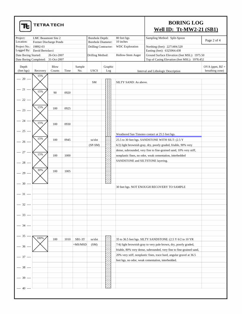
BORING LOGWell ID: Tt-MW2-21 (SB1)
---- 0 ----
---- 1 ----
Borehole Depth: Borehole Diameter: Drilling Contractor:
Drilling Method:
Interval and Lithologic Description
Northing (feet): 2271404.520 Easting (feet): 6325064.438 Ground Surface Elevation (feet MSL): 1975.50 Top of Casing Elevation (feet MSL): 1978.452
---- 20 ----
100%
100%
100%
67%
15%
15%
Page 2 of 4 Project: 80 feet bgs Sampling Method: Split-Spoon Location: 10 inches Project No.: WDC Exploration Logged By:
Hollow-Stem Auger
Depth(feet bgs) Recovery
Blow Counts Time
Sample No. USCS
Graphic Log
OVA (ppm, BZ = breathing zone)
LMC Beaumont Site 2
Date Boring Started: Date Boring Completed: 31-Oct-2007
26-Oct-2007David Bertolacci19892-03Former Discharge Ponds
BORING LOGWell ID: Tt-MW2-21 (SB1)
Borehole Depth: Borehole Diameter: Drilling Contractor:
Drilling Method:
Interval and Lithologic Description
Northing (feet): 2271404.520 Easting (feet): 6325064.438 Ground Surface Elevation (feet MSL): 1975.50 Top of Casing Elevation (feet MSL): 1978.452
SM SILTY SAND: As above.
90 0920
100 0925
100 0930
Weathered San Timoteo contact at 25.5 feet bgs.
100 0945 ss/slst 25.5 to 30 feet bgs. SANDSTONE WITH SILT: (2.5 Y
(SP-SM) 6/2) light brownish gray, dry, poorly graded, friable, 90% very
dense, subrounded, very fine to fine-grained sand, 10% very stiff,
100 1000 nonplastic fines, no odor, weak cementation, interbedded
SANDSTONE and SILTSTONE layering.
100 1005
30 feet bgs. NOT ENOUGH RECOVERY TO SAMPLE
100 1010 SB1-35' ss/slst 35 to 36.5 feet bgs. SILTY SANDSTONE: (2.5 Y 6/2 to 10 YR
+MS/MSD (SM) 7/4) light brownish gray to very pale brown, dry, poorly graded,
friable, 80% very dense, subrounded, very fine to fine-grained sand,
20% very stiff, nonplastic fines, trace hard, angular gravel at 36.5
feet bgs, no odor, weak cementation, interbedded.
---- 20 ----
---- 21 ----
---- 26 ----
---- 27 ----
---- 24 ----
---- 25 ----
---- 22 ----
---- 23 ----
---- 30 ----
---- 31 ----
---- 28 ----
---- 29 ----
---- 34 ----
---- 35 ----
---- 32 ----
---- 33 ----
---- 38 ----
---- 39 ----
---- 36 ----
---- 37 ----
---- 40 ----
15%
15%
15%
15%
15%
15%
30%
100%
Page 3 of 4 Project: 80 feet bgs Sampling Method: Split-Spoon Location: 10 inches Project No.: WDC Exploration Logged By:
Hollow-Stem Auger
Depth(feet bgs) Recovery
Blow Counts Time
Sample No. USCS
Graphic Log
OVA (ppm, BZ = breathing zone)
LMC Beaumont Site 2
Date Boring Started: Date Boring Completed: 31-Oct-2007
26-Oct-2007David Bertolacci19892-03Former Discharge Ponds
BORING LOGWell ID: Tt-MW2-21 (SB1)
Borehole Depth: Borehole Diameter: Drilling Contractor:
Drilling Method:
Interval and Lithologic Description
Northing (feet): 2271404.520 Easting (feet): 6325064.438 Ground Surface Elevation (feet MSL): 1975.50 Top of Casing Elevation (feet MSL): 1978.452
100 1025 SB1-40' ss/slst 40 to 41.5 feet bgs. SANDSTONE WITH SILTSTONE: (10 YR
(SP-SM) 6/4) light yellowish brown, dry to slightly damp, friable, 90%
very dense, subrounded, very fine to fine-grained sand, 10%
nonplastic fines, no odor, weak cementation.
100 1040 SB1-45' ss (SP) 45 to 46.5 feet bgs. SANDSTONE: (2.5 Y 7/2) light gray, dry to
damp, poorly graded, friable, 95% very dense, subrounded, very
fine to fine-grained sand, 5% nonplastic fines, no odor, weak
cementation.
Stop drilling after collecting 50 ft samples, let stand over weekend,
100 1045 SB1-50' ss (SP) 50 to 51.5 feet bgs.SANDSTONE: As above.
1050 SB1-50'Dup
Resume drilling on 29-Oct-2007.
80 1218 SB1-55' slst (ML) 55 to 56.5 feet bgs. SANDY SILTSTONE: (2.5 Y 5/2) grayish
brown, dry, poorly graded, platy, very hard bedding, 80% very
stiff nonplastic fines, 20% subrounded, very fine-grained sand,
no odor, micaceous, weak cementation.
Augers grinding at 57 to 60 feet bgs; cuttings steaming.
Very hard, micaceous, platy siltstone in cuttings.
---- 40 ----
---- 43 ----
---- 44 ----
---- 41 ----
---- 42 ----
---- 47 ----
---- 48 ----
---- 45 ----
---- 46 ----
---- 54 ----
---- 51 ----
---- 52 ----
---- 49 ----
---- 50 ----
---- 60 ----
---- 59 ----
---- 57 ----
---- 58 ----
---- 55 ----
---- 56 ----
---- 53 ----
100%
100%
33%
33%

Page 4 of 4 Project: 80 feet bgs Sampling Method: Split-Spoon Location: 10 inches Project No.: WDC Exploration Logged By:
Hollow-Stem Auger
Depth(feet bgs) Recovery
Blow Counts Time
Sample No. USCS
Graphic Log
OVA (ppm, BZ = breathing zone)
LMC Beaumont Site 2
Date Boring Started: Date Boring Completed: 31-Oct-2007
26-Oct-2007David Bertolacci19892-03Former Discharge Ponds
BORING LOGWell ID: Tt-MW2-21 (SB1)
Borehole Depth: Borehole Diameter: Drilling Contractor:
Drilling Method:
Interval and Lithologic Description
Northing (feet): 2271404.520 Easting (feet): 6325064.438 Ground Surface Elevation (feet MSL): 1975.50 Top of Casing Elevation (feet MSL): 1978.452
40 1250 SB1-60' slst/mst 60 to 60.5 feet bgs. SANDY SILTSTONE/MUDSTONE: (2.5 Y
50 (ML/CL) 6/3) light yellowish brown, dry, poorly graded, 60% very stiff
fines with no to low plasticity, 35% very dense, subrounded,
very fine-grained sand, 5% friable to hard, angular, coarse gravel,
maximum size = 1 inch, no odor, weak cementation.
Augers grinding hard at 63.5 feet bgs; instruct driller to stop and
let sit overnight.
Resume Drilling on 30-Oct-2007.
65 feet bgs. No recovery, as above (from cuttings).
1st Water at approximately 70 feet bgs.
100 1723 SB1-70' ss (SP) 70 to 71.5 feet bgs. SANDSTONE: (2.5 Y 6/1) gray, wet, poorly
graded, 100% very dense, subrounded, medium to very coarse-
grained sand, trace hard, angular gravel, maximum size = 1 inch,
no odor, weak to moderate cementation.
1730 Augers at 75 feet bgs, no sample, stop drilling and let sit overnight.
0830 Resume drilling on 30-Oct-2007, no samples, as above (from cuttings).
Began setting well 30-Oct-2007; completed well 31-Oct-2007.
Total Depth = 80 feet bgs. Well constructed at 79 feet bgs.
---- 61 ----
---- 62 ----
---- 63 ----
---- 64 ----
---- 65 ----
---- 66 ----
---- 67 ----
---- 68 ----
---- 69 ----
---- 70 ----
---- 71 ----
---- 72 ----
---- 73 ----
---- 74 ----
---- 75 ----
---- 76 ----
---- 80 ----
---- 77 ----
---- 78 ----
---- 79 ----
---- 60 ----67%
100%
Page 1 of 4 Project: 80 feet bgs Sampling Method: Split-Spoon Location: 10 inches Project No.: WDC Exploration Logged By:
Hollow-Stem Auger
Depth(feet bgs) Recovery
Blow Counts Time
Sample No. USCS
Graphic Log
OVA (ppm, BZ = breathing zone)
Surface: grass/topsoil.
H SP-SM 0 to 5 feet bgs. POORLY GRADED SAND WITH SILT: (10 YR
A 7/3) very pale brown, dry, poorly graded, 90% very loose,
N subrounded, very fine to fine-grained sand, 10% nonplastic fines,
D no staining or odor.
A
U
G
E
R
10 0915 SM 5 to 6.5 feet bgs. SILTY SAND: (10 YR 4/3) brown, dry, poorly
10 graded, 80% loose, subrounded, very fine to fine-grained sand,
12 20% nonplastic fines, trace friable, subangular, fine gravel,
maximum size = 1/4 to 3/8 inch, no odor
7 0920 SM 10 to 11.5 feet bgs. SILTY SAND: (10 YR 5/3) brown, dry,
9 poorly graded, 85% very loose, subrounded, very fine to fine-
11 grained sand, 15% nonplastic fines, trace friable, subrounded,fine gravel, maximum size = 1/2 inch, no odor.
14 0925 SB2-15' SM/SC 15 to 19.5 feet bgs. SILTY/CLAYEY SAND: (10 YR 5/4)
17 0930 SB2-15'-DUP yellowish brown, dry, poorly graded, 85% medium dense,
21 subrounded, very fine to medium-grained sand, 10% fines with
12 no to low plasticity, increasing plastic fines at 16.5 feet bgs, no odor.
14
18
25
500936 SB2-20' above contact Weathered San Timoteo formation contact at 19.5 feet bgs.
next pg. slst 19.5 to 20 feet bgs: SILTSTONE: (2.5 Y 7/2) olive gray.
Northing (feet): 2271386.439 Easting (feet): 6324876.337 Ground Surface Elevation (feet MSL): 1973.05 Top of Casing Elevation (feet MSL): 1975.861
---- 9 ----
BORING LOGWell ID: Tt-MW2-22 (SB2)
---- 0 ----
---- 1 ----
Borehole Depth: Borehole Diameter: Drilling Contractor:
Drilling Method:
---- 14 ----
---- 15 ----
Interval and Lithologic Description
---- 2 ----
---- 3 ----
---- 4 ----
---- 5 ----
---- 6 ----
---- 7 ----
---- 8 ----
---- 10 ----
---- 11 ----
---- 12 ----
---- 13 ----
50%
---- 16 ----
---- 17 ----
---- 18 ----
---- 20 ----
LMC Beaumont Site 2
Date Boring Started: Date Boring Completed: 31-Oct-2007
30-Oct-2007David Bertolacci19892-03Former Discharge Ponds
---- 19 ----
100%
100%
100%
100%

Page 2 of 4 Project: 80 feet bgs Sampling Method: Split-Spoon Location: 10 inches Project No.: WDC Exploration Logged By:
Hollow-Stem Auger
Depth(feet bgs) Recovery
Blow Counts Time
Sample No. USCS
Graphic Log
OVA (ppm, BZ = breathing zone)
Northing (feet): 2271386.439 Easting (feet): 6324876.337 Ground Surface Elevation (feet MSL): 1973.05 Top of Casing Elevation (feet MSL): 1975.861
BORING LOGWell ID: Tt-MW2-22 (SB2)
Borehole Depth: Borehole Diameter: Drilling Contractor:
Drilling Method:
Interval and Lithologic Description
LMC Beaumont Site 2
Date Boring Started: Date Boring Completed: 31-Oct-2007
30-Oct-2007David Bertolacci19892-03Former Discharge Ponds
35 ss/slst 20 to 25.5 feet bgs. SANDSTONE/SILTSTONE: (2.5 Y 7/2 to
50 5/4) light gray to light olive brown, dry, poorly graded, 60% very
85/6" dense, very fine-grained sand, 40% stiff, non to low plasticity
fines, platy layering, weak cementation, interbedded ss and slst,
no odor.
90/6" ss/slst SILTY SANDSTONE: As above, decreasing fines from 22.5 to
24 feet bgs.
85/6" 0952 ss/slst SILTY SANDSTONE: As above, (2.5 Y 5/3) light olive brown,
friable to platy layering, damp, poorly graded, 85% very dense,
subrounded, very fine to fine-grained sand, 15% nonplastic fines, 0.0
micaceous, weak cementation, no odor. BZ = 0.0
100 1020 SB2-30' ss/slst 30 to 31.5 feet bgs. SILTY SANDSTONE: (2.5 Y 6/2 to 6/4) 21.1
+MS/MSD light brownish gray to light yellowish brown, dry to damp, poorly BZ = 0.0
graded, friable to platy layering, 80% very dense, subrounded, very
fine to fine-grained sand, 20% nonplastic fines, weak cementation, Cuttings:
strong volatile organic compound (VOC) odor (like PVC cement). 85
BZ = 4.8
100 1025 SB2-35' ss/slst 35 to 36.5 feet bgs. SILTY SANDSTONE: (2.5 Y 6/4) 67
light yellowish brown, damp, poorly graded, friable to platy BZ = 0.0
layering, 85% very dense, subrounded, very fine
to fine-grained sand, 15% nonplastic fines, micaceous, weak
cementation, strong VOC (PVC cement-like) odor.
---- 38 ----
---- 39 ----
---- 36 ----
---- 37 ----
---- 40 ----
---- 34 ----
---- 35 ----
---- 32 ----
---- 33 ----
---- 30 ----
---- 31 ----
---- 28 ----
---- 29 ----
---- 21 ----
---- 26 ----
---- 27 ----
---- 24 ----
---- 25 ----
---- 22 ----
---- 23 ----
---- 20 ----33%
25%
67%
33%
100%
67%

Page 3 of 4 Project: 80 feet bgs Sampling Method: Split-Spoon Location: 10 inches Project No.: WDC Exploration Logged By:
Hollow-Stem Auger
Depth(feet bgs) Recovery
Blow Counts Time
Sample No. USCS
Graphic Log
OVA (ppm, BZ = breathing zone)
Northing (feet): 2271386.439 Easting (feet): 6324876.337 Ground Surface Elevation (feet MSL): 1973.05 Top of Casing Elevation (feet MSL): 1975.861
BORING LOGWell ID: Tt-MW2-22 (SB2)
Borehole Depth: Borehole Diameter: Drilling Contractor:
Drilling Method:
Interval and Lithologic Description
LMC Beaumont Site 2
Date Boring Started: Date Boring Completed: 31-Oct-2007
30-Oct-2007David Bertolacci19892-03Former Discharge Ponds
100 1045 SB2-40' ss 40 to 41.5 feet bgs. SANDSTONE: (2.5 Y 6/3) light yellowish 35.5
brown, damp, poorly graded, 100% very dense, subrounded, very BZ = 0.0
fine to fine-grained sand, trace nonplastic fines, strong VOC odor.
35 1050 SB2-45' ss/slst 45 to 46.5 feet bgs. SILTY SANDSTONE: (2.5 Y 6/4) light 51.8 - 120
40 yellowish brown, dry, poorly graded, friable, platy layering, 85% BZ = 0.0
50 very dense, subrounded, very fine to fine-grained sand, 15%
nonplastic fines, micaceous, strong VOC odor.
33 1110 SB2-50' ss/slst 50 to 51.5 feet bgs. SILTY SANDSTONE: (2.5 Y 7/3) pale 10.8
35 yellow, dry, poorly graded, friable, platy layering, 80% very BZ = 0.0
40 dense, subrounded, very fine to medium-grained sand, 20%
nonplastic fines, trace fine gravel, maximum size = 1/2 inch,
slight VOC odor.
Augers grinding from 50 to 55 feet bgs.
40 1144 SB2-55' ss 55 to 56.5 fet bgs. SANDSTONE: (2.5 Y 7/2 to 6/4) light gray 0.1
50 to light yellowish brown, dry, poorly graded, hard, 95% very BZ = 0.0
dense, subrounded, very fine to fine-grained sand, 5% nonplastic
fines, strong cementation at 55 feet bgs to weak cementation below
56 feet bgs, no odor.
---- 55 ----
---- 56 ----
---- 53 ----
---- 60 ----
---- 54 ----
---- 59 ----
---- 57 ----
---- 58 ----
---- 51 ----
---- 52 ----
---- 49 ----
---- 50 ----
---- 47 ----
---- 48 ----
---- 45 ----
---- 46 ----
---- 43 ----
---- 44 ----
---- 41 ----
---- 42 ----
---- 40 ----
100%
100%
50%
50%
Page 4 of 4 Project: 80 feet bgs Sampling Method: Split-Spoon Location: 10 inches Project No.: WDC Exploration Logged By:
Hollow-Stem Auger
Depth(feet bgs) Recovery
Blow Counts Time
Sample No. USCS
Graphic Log
OVA (ppm, BZ = breathing zone)
Northing (feet): 2271386.439 Easting (feet): 6324876.337 Ground Surface Elevation (feet MSL): 1973.05 Top of Casing Elevation (feet MSL): 1975.861
BORING LOGWell ID: Tt-MW2-22 (SB2)
Borehole Depth: Borehole Diameter: Drilling Contractor:
Drilling Method:
Interval and Lithologic Description
LMC Beaumont Site 2
Date Boring Started: Date Boring Completed: 31-Oct-2007
30-Oct-2007David Bertolacci19892-03Former Discharge Ponds
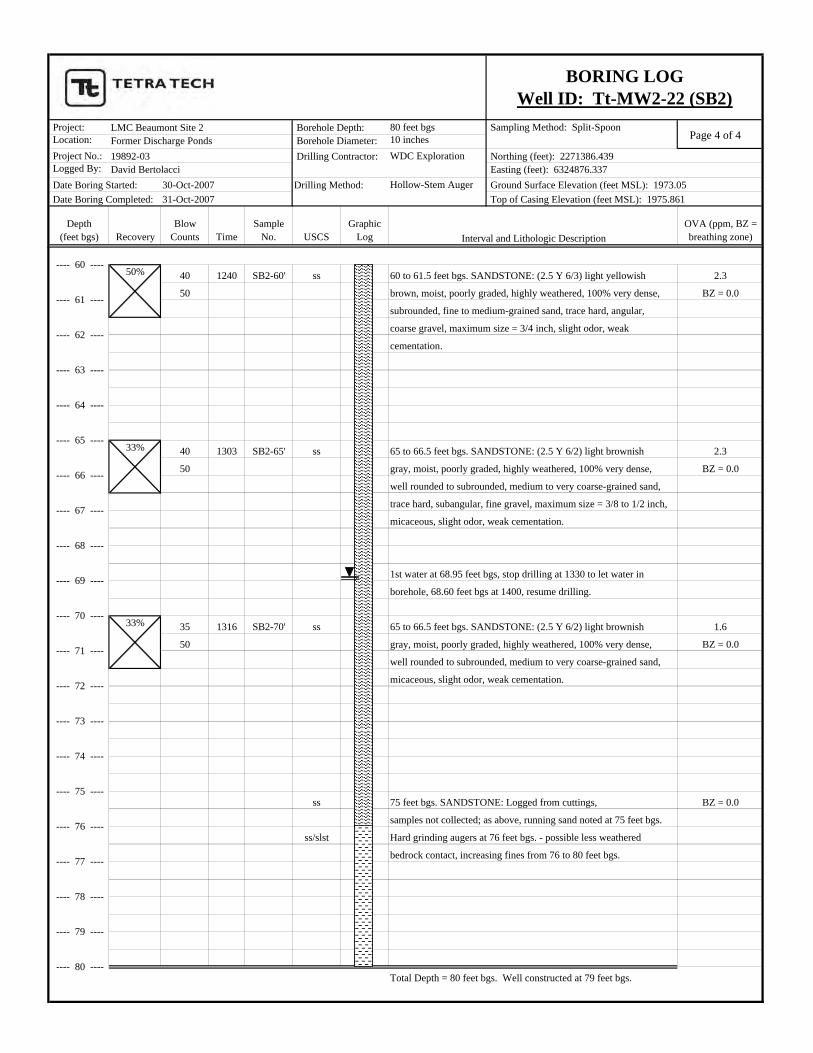
40 1240 SB2-60' ss 60 to 61.5 feet bgs. SANDSTONE: (2.5 Y 6/3) light yellowish 2.3
50 brown, moist, poorly graded, highly weathered, 100% very dense, BZ = 0.0
subrounded, fine to medium-grained sand, trace hard, angular,
coarse gravel, maximum size = 3/4 inch, slight odor, weak
cementation.
40 1303 SB2-65' ss 65 to 66.5 feet bgs. SANDSTONE: (2.5 Y 6/2) light brownish 2.3
50 gray, moist, poorly graded, highly weathered, 100% very dense, BZ = 0.0
well rounded to subrounded, medium to very coarse-grained sand,
trace hard, subangular, fine gravel, maximum size = 3/8 to 1/2 inch,
micaceous, slight odor, weak cementation.
1st water at 68.95 feet bgs, stop drilling at 1330 to let water in
borehole, 68.60 feet bgs at 1400, resume drilling.
35 1316 SB2-70' ss 65 to 66.5 feet bgs. SANDSTONE: (2.5 Y 6/2) light brownish 1.6
50 gray, moist, poorly graded, highly weathered, 100% very dense, BZ = 0.0
well rounded to subrounded, medium to very coarse-grained sand,
micaceous, slight odor, weak cementation.
ss 75 feet bgs. SANDSTONE: Logged from cuttings, BZ = 0.0
samples not collected; as above, running sand noted at 75 feet bgs.
ss/slst Hard grinding augers at 76 feet bgs. - possible less weathered
bedrock contact, increasing fines from 76 to 80 feet bgs.
Total Depth = 80 feet bgs. Well constructed at 79 feet bgs.
---- 60 ----
---- 80 ----
---- 77 ----
---- 78 ----
---- 79 ----
---- 73 ----
---- 74 ----
---- 75 ----
---- 76 ----
---- 69 ----
---- 70 ----
---- 71 ----
---- 72 ----
---- 65 ----
---- 66 ----
---- 67 ----
---- 68 ----
---- 61 ----
---- 62 ----
---- 63 ----
---- 64 ----
33%
33%
50%

Page 1 of 5 Project: 100 feet bgs Sampling Method: Split-Spoon Location: 10 inches Project No.: WDC Exploration Logged By:
Hollow-Stem Auger
Depth(feet bgs) Recovery
Blow Counts Time
Sample No. USCS
Graphic Log
OVA (ppm, BZ = breathing zone)
Surface: grass/topsoil.
6 SP-SM 0 to 5 feet bgs. POORLY RGADED SAND WITH SILT:
6 1010 SB3-0.5' (10 YR 5/3) brown, dry, poorly graded, 90% very loose,
8 subrounded, very fine to fine-grained sand, 10% nonplastic fines,
no staining or odor.
Sample collected in brass sleeves with 2 1/2 inch split-spoon sampler
using hydraulic hammer for geotechnical testing.10 1012 SB3-5-5.5' SM/SC 5 to 8 feet bgs. SILTY/CLAYEY SAND: (10 YR 5/3) brown, dry,
12 SB3-5.5-6' poorly graded, 80% loose, subrounded, very fine to fine-grained
13 sand, 20% fines with no to low plasticity, trace friable, fine gravel,
8 1012 SB3-5' maximm size = 3/8 inch, no odor.
8
10
10 1025 SB3-10' SM 10 to 17 feet bgs. SILTY SAND: (10 YR 5/3) brown, dry, poorly
10 graded, 80% loose, subrounded, very fine to fine-grained sand,
12 20% nonplastic fines, trace friable, fine gravel, maximm size =10 3/8 inch, no odor.
10
12
10
10
12
12
14 1038 SB3-15' SM SILTY SAND: As above, decreasing fines to 15% nonplastic fines.
18
4050 Weathered San Timoteo formation contact at 17 feet bgs.
ss/slst/clst 17 to 20.5 feet bgs: SILTY/CLAYEY SANDSTONE: (2.5 Y 5/3 to
45 6/3) light olive brown to light yellowish brown, dry, poorly graded,
50 friable, platy layering, 85% very dense, subrounded, very fine to
fine-grained sand, 15% fines with no to low plasticity, no odor,
30 1102 SB3-19-19.5' weak cementation.
124/3" SB3-19.5-20' Sample collected in brass sleeves with 2 1/2 inch split-spoon sampler
using hydraulic hammer for geotechnical testing.
100%
100%
100%
100%
100%
100%
100%
100%
100%
100%
---- 20 ----
Northing (feet): 2271308.798 Easting (feet): 6325082.502 Ground Surface Elevation (feet MSL): 1993.05 Top of Casing Elevation (feet MSL): 1995.172
BORING LOGWell ID: Tt-MW2-23 (SB3)
---- 0 ----
---- 1 ----
Borehole Depth: Borehole Diameter: Drilling Contractor:
Drilling Method:
Interval and Lithologic Description
---- 2 ----
---- 3 ----
---- 4 ----
---- 5 ----
---- 6 ----
---- 7 ----
---- 8 ----
---- 9 ----
---- 10 ----
---- 11 ----
---- 12 ----
---- 13 ----
---- 19 ----
---- 14 ----
---- 15 ----
---- 16 ----
---- 17 ----
---- 18 ----
LMC Beaumont Site 2
Date Boring Started: Date Boring Completed: 2-Nov-2007
1-Nov-2007Linda Margullis19892-03Former Discharge Ponds

Page 2 of 5 Project: 100 feet bgs Sampling Method: Split-Spoon Location: 10 inches Project No.: WDC Exploration Logged By:
Hollow-Stem Auger
Depth(feet bgs) Recovery
Blow Counts Time
Sample No. USCS
Graphic Log
OVA (ppm, BZ = breathing zone)
Northing (feet): 2271308.798 Easting (feet): 6325082.502 Ground Surface Elevation (feet MSL): 1993.05 Top of Casing Elevation (feet MSL): 1995.172
BORING LOGWell ID: Tt-MW2-23 (SB3)
Borehole Depth: Borehole Diameter: Drilling Contractor:
Drilling Method:
Interval and Lithologic Description
LMC Beaumont Site 2
Date Boring Started: Date Boring Completed: 2-Nov-2007
1-Nov-2007Linda Margullis19892-03Former Discharge Ponds
45/50 1119 SB3-20' ss/slst 20 to 20.5 feet bgs. SILTY SANDSTONE: As above,
SB3-20'-DUP increasing grain size, trace medium-grained sand.
35 1130 SB3-25' ss/slst 25 to 26.5 feet bgs: SANDSTONE/SILTSTONE: (2.5 Y 6/3)
50 1131 SB3-25'-DUP light yellowish brown, dry, poorly graded, friable, platy layering,
85% very dense, subrounded, very fine to fine-grained sand,
15% nonplastic fines, no odor, weak cementation.
100 1132 SB3-30' ss/slst 30 to 31.5 feet bgs: SANDSTONE/SILTSTONE: (2.5 Y 7/2)
light gray, dry, poorly graded, friable, platy layering,
85% very dense, subrounded, very fine to fine-grained sand,
15% nonplastic fines, no odor, weak cementation, micaceous.
45 1155 SB3-35' ss/slst 30 to 31.5 feet bgs: SILTY SANDSTONE: (2.5 Y 4/3)
50 olive brown, dry, poorly graded, friable, platy layering,
60% very dense, subrounded, very fine to fine-grained sand,
40% nonplastic fines, no odor, weak cementation, micaceous.
80%
33%
50%
---- 40 ----
---- 38 ----
---- 39 ----
---- 36 ----
---- 37 ----
---- 34 ----
---- 35 ----
---- 32 ----
---- 33 ----
---- 30 ----
---- 31 ----
---- 28 ----
---- 29 ----
---- 21 ----
---- 26 ----
---- 27 ----
---- 24 ----
---- 25 ----
---- 22 ----
---- 23 ----
---- 20 ----
Page 3 of 5 Project: 100 feet bgs Sampling Method: Split-Spoon Location: 10 inches Project No.: WDC Exploration Logged By:
Hollow-Stem Auger
Depth(feet bgs) Recovery
Blow Counts Time
Sample No. USCS
Graphic Log
OVA (ppm, BZ = breathing zone)
Northing (feet): 2271308.798 Easting (feet): 6325082.502 Ground Surface Elevation (feet MSL): 1993.05 Top of Casing Elevation (feet MSL): 1995.172
BORING LOGWell ID: Tt-MW2-23 (SB3)
Borehole Depth: Borehole Diameter: Drilling Contractor:
Drilling Method:
Interval and Lithologic Description
LMC Beaumont Site 2
Date Boring Started: Date Boring Completed: 2-Nov-2007
1-Nov-2007Linda Margullis19892-03Former Discharge Ponds
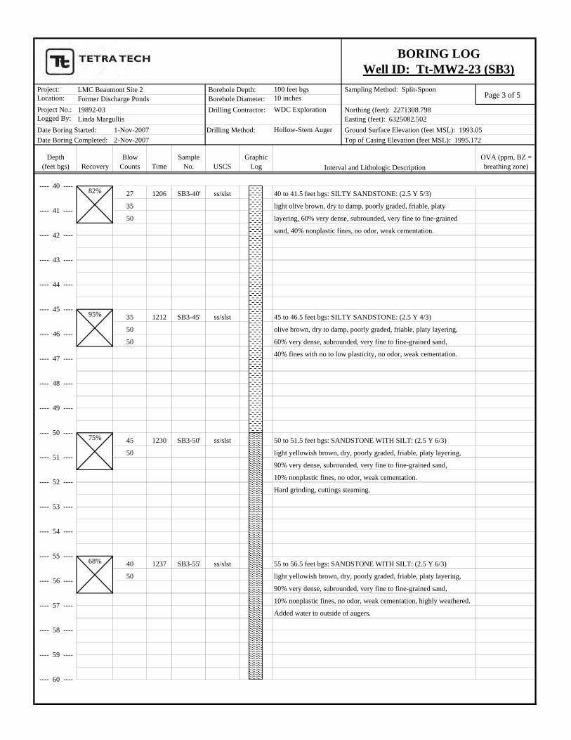
27 1206 SB3-40' ss/slst 40 to 41.5 feet bgs: SILTY SANDSTONE: (2.5 Y 5/3)
35 light olive brown, dry to damp, poorly graded, friable, platy
50 layering, 60% very dense, subrounded, very fine to fine-grained
sand, 40% nonplastic fines, no odor, weak cementation.
35 1212 SB3-45' ss/slst 45 to 46.5 feet bgs: SILTY SANDSTONE: (2.5 Y 4/3)
50 olive brown, dry to damp, poorly graded, friable, platy layering,
50 60% very dense, subrounded, very fine to fine-grained sand,
40% fines with no to low plasticity, no odor, weak cementation.
45 1230 SB3-50' ss/slst 50 to 51.5 feet bgs: SANDSTONE WITH SILT: (2.5 Y 6/3)
50 light yellowish brown, dry, poorly graded, friable, platy layering,
90% very dense, subrounded, very fine to fine-grained sand,
10% nonplastic fines, no odor, weak cementation.
Hard grinding, cuttings steaming.
40 1237 SB3-55' ss/slst 55 to 56.5 feet bgs: SANDSTONE WITH SILT: (2.5 Y 6/3)
50 light yellowish brown, dry, poorly graded, friable, platy layering,
90% very dense, subrounded, very fine to fine-grained sand,
10% nonplastic fines, no odor, weak cementation, highly weathered.
Added water to outside of augers.
95%
75%
68%
82%
---- 56 ----
---- 53 ----
---- 60 ----
---- 59 ----
---- 57 ----
---- 58 ----
---- 55 ----
---- 54 ----
---- 51 ----
---- 52 ----
---- 49 ----
---- 50 ----
---- 47 ----
---- 48 ----
---- 45 ----
---- 46 ----
---- 43 ----
---- 44 ----
---- 41 ----
---- 42 ----
---- 40 ----

Page 4 of 5 Project: 100 feet bgs Sampling Method: Split-Spoon Location: 10 inches Project No.: WDC Exploration Logged By:
Hollow-Stem Auger
Depth(feet bgs) Recovery
Blow Counts Time
Sample No. USCS
Graphic Log
OVA (ppm, BZ = breathing zone)
Northing (feet): 2271308.798 Easting (feet): 6325082.502 Ground Surface Elevation (feet MSL): 1993.05 Top of Casing Elevation (feet MSL): 1995.172
BORING LOGWell ID: Tt-MW2-23 (SB3)
Borehole Depth: Borehole Diameter: Drilling Contractor:
Drilling Method:
Interval and Lithologic Description
LMC Beaumont Site 2
Date Boring Started: Date Boring Completed: 2-Nov-2007
1-Nov-2007Linda Margullis19892-03Former Discharge Ponds
40 1259 SB3-60' ss 60 to 61.5 feet bgs: SANDSTONE: (2.5 Y 6/3) light yellowish
60 brown, dry to damp, poorly graded, friable, platy layering,
100% very dense, subrounded, very fine to fine-grained sand,
trace nonplastic fines, no odor, weak cementation, highly
weathered.
Added water to outside of augers.
25 1321 SB3-65' ss 65 to 66.5 feet bgs: SANDSTONE: (2.5 Y 6/3) light yellowish
38 brown, dry to damp, poorly graded, friable, platy layering,
50 100% very dense, subrounded, very fine to fine-grained sand,
trace nonplastic fines, no odor, weak cementation, highly
weathered.
25 1338 SB3-70' slst/mst 70 to 71.5 feet bgs. SILTSTONE/MUDSTONE: (2.5 Y 6/3)
25 light yellowish brown, dry to damp, friable, 60% very stiff fines
40 with no to low plasticity, 35% very dense, subrounded, very fine-
grained sand, no odor.
Cuttings steaming.
40 1400 SB3-75' slst/mst 75 to 76.5 feet bgs. SILTSTONE/MUDSTONE: (2.5 Y 5/3)
50 light yellowish brown, dry to damp, platy layering, 60% very stiff
fines with no to low plasticity, 35% very dense, subrounded, very
fine-grained sand, no odor.
Cuttings steaming.
20%---- 60 ----
---- 80 ----
---- 77 ----
---- 78 ----
---- 79 ----
---- 73 ----
---- 74 ----
---- 75 ----
---- 76 ----
---- 69 ----
---- 70 ----
---- 71 ----
---- 72 ----
---- 65 ----
---- 66 ----
---- 67 ----
---- 68 ----
---- 61 ----
---- 62 ----
---- 63 ----
---- 64 ----
40%
90%
100%

Page 5 of 5 Project: 100 feet bgs Sampling Method: Split-Spoon Location: 10 inches Project No.: WDC Exploration Logged By:
Hollow-Stem Auger
Depth(feet bgs) Recovery
Blow Counts Time
Sample No. USCS
Graphic Log
OVA (ppm, BZ = breathing zone)
Northing (feet): 2271308.798 Easting (feet): 6325082.502 Ground Surface Elevation (feet MSL): 1993.05 Top of Casing Elevation (feet MSL): 1995.172
BORING LOGWell ID: Tt-MW2-23 (SB3)
Borehole Depth: Borehole Diameter: Drilling Contractor:
Drilling Method:
Interval and Lithologic Description
LMC Beaumont Site 2
Date Boring Started: Date Boring Completed: 2-Nov-2007
1-Nov-2007Linda Margullis19892-03Former Discharge Ponds
45 1518 SB3-80' ss/slst 80 to 81.5 feet bgs: SANDSTONE/SILTSTONE: (2.5 Y 6/3)
50 light yellowish brown, dry, poorly graded, friable, platy layering,
80% very dense, subrounded, fine-grained sand, 20% nonplastic
fines, no odor, weak cementation.
Augers grinding, cuttings steaming, added water to outside of augers.
45 1542 SB3-85' ss/slst 85 to 86.5 feet bgs: SANDSTONE WITH SILT: (2.5 Y 6/3)
50 light yellowish brown, dry to damp, poorly graded, friable, platy
layering, 90% very dense, subrounded, fine-grained sand, 10%
nonplastic fines, no odor, weak cementation.
Cuttings steaming.
First water at approximately 90 feet bgs.
40 1620 SB3-90' ss 90 to 91.5 feet bgs: SANDSTONE: (2.5 Y 5/2) grayish brown,
50 wet, poorly graded, friable, platy layering, 100% very dense,
subrounded, fine to coarse-grained sand, weak cementation, highly
weathered, no odor.
Cuttings steaming.
Continue logging from cuttings; no more analytical samples collected.
ss SANDSTONE: As above, logged from cuttings.
ss SANDSTONE: As above, logged from cuttings.
Total Depth = 100 feet bgs. Well constructed at 98.5 feet bgs.
---- 96 ----
---- 97 ----
---- 90 ----
---- 91 ----
---- 88 ----
---- 89 ----
---- 99 ----
---- 100 ----
---- 94 ----
---- 95 ----
---- 92 ----
---- 93 ----
---- 87 ----
---- 84 ----
---- 85 ----
---- 82 ----
---- 83 ----
---- 86 ----
---- 80 ----
---- 81 ----
---- 98 ----
30%
50%
80%

Page 1 of 4 Project: 67.5 feet bgs Sampling Method: Split-Spoon Location: 10 inches Project No.: WDC Exploration Logged By:
Hollow-Stem Auger
Depth(feet bgs) Recovery
Blow Counts Time
Sample No. USCS
Graphic Log
OVA (ppm, BZ = breathing zone)
Surface: grass/topsoil.
H SM 0 to 5 feet bgs. SILTY SAND: (10 YR 6/3) light yellowish
A brown, dry, poorly graded, 75% loose, subrounded, very fine
N to fine-grained sand, 20% nonplastic fines, 5% hard, subangular,
D fine gravel, maximum size = 1/2 inch, no staining or odor.
A
U
G
E
R
6 0950 -- SM 5 to 6.5 feet bgs. SILTY SAND: (10 YR 6/3) light yellowish
8 brown, dry, poorly graded, 75% loose, subrounded, very fine
8 to fine-grained sand, 20% nonplastic fines, 5% hard, subangular,
fine gravel, maximum size = 1/2 inch, no staining or odor.
8 0955 -- SM 10 to 11.5 feet bgs. SILTY SAND: (7.5 YR 5/4) brown
10 dry, poorly graded, 75% loose, subrounded, very fine
10 to fine-grained sand, 20% nonplastic fines, 5% hard, subangular,fine gravel, maximum size = 1/2 inch, no staining or odor.
10 1002 SB6-15' SM 15 to 16.5 feet bgs. SILTY SAND: (7.5 YR 5/4) brown,
12 dry, poorly graded, 75% loose, subrounded, very fine
14 to fine-grained sand, 20% nonplastic fines, 5% hard, subangular,
fine gravel, maximum size = 1/2 inch, no staining or odor.
100%
100%
50%
---- 20 ----
Northing (feet): 2271311.555 Easting (feet): 6325253.335 Ground Surface Elevation (feet MSL): 1961.81 Top of Casing Elevation (feet MSL): 1964.259
BORING LOGWell ID: Tt-MW2-24 (SB6)
---- 0 ----
---- 1 ----
Borehole Depth: Borehole Diameter: Drilling Contractor:
Drilling Method:
Interval and Lithologic Description
---- 13 ----
---- 2 ----
---- 3 ----
---- 4 ----
---- 5 ----
---- 6 ----
---- 7 ----
---- 18 ----
---- 8 ----
---- 9 ----
---- 10 ----
---- 11 ----
---- 12 ----
---- 14 ----
---- 15 ----
---- 16 ----
---- 17 ----
LMC Beaumont Site 2
Date Boring Started: Date Boring Completed: 26-Oct-2007
25-Oct-2007David Bertolacci19892-03Former Discharge Ponds
---- 19 ----

Page 2 of 4 Project: 67.5 feet bgs Sampling Method: Split-Spoon Location: 10 inches Project No.: WDC Exploration Logged By:
Hollow-Stem Auger
Depth(feet bgs) Recovery
Blow Counts Time
Sample No. USCS
Graphic Log
OVA (ppm, BZ = breathing zone)
Northing (feet): 2271311.555 Easting (feet): 6325253.335 Ground Surface Elevation (feet MSL): 1961.81 Top of Casing Elevation (feet MSL): 1964.259
BORING LOGWell ID: Tt-MW2-24 (SB6)
Borehole Depth: Borehole Diameter: Drilling Contractor:
Drilling Method:
Interval and Lithologic Description
LMC Beaumont Site 2
Date Boring Started: Date Boring Completed: 26-Oct-2007
25-Oct-2007David Bertolacci19892-03Former Discharge Ponds
10 1009 SB6-20' SM 20 to 21.5 feet bgs. SILTY SAND: (7.5 YR 5/4) brown,
10 dry, poorly graded, 75% loose, subrounded, very fine
10 to fine-grained sand, 20% nonplastic fines, 5% hard, subangular,
fine gravel, maximum size = 1/2 inch, no staining or odor.
11 1014 SB6-25' SM 25 to 26.5 feet bgs. SILTY SAND: (7.5 YR 5/4) brown,
13 dry, poorly graded, 75% loose, subrounded, very fine
15 to fine-grained sand, 20% nonplastic fines, 5% hard, subangular,
18 SP-SM fine gravel, maximum size = 1/2 inch, no staining or odor.
18 26.5 to 31 feet bgs. POORLY GRADED SAND WITH SILT:
23 (7.5 YR 5/4) brown, damp to moist, poorly graded, 80% medium
20 dense, subrounded, very fine to coarse-grained sand, 10% non-
20 plastic fines, 10% hard, angular gravel, no odor, increasing
20 coarse sand at 28 feet bgs.
19
21
25
22 Interbedded fine sand stringers and gravel at 31 feet bgs.
28 SP-SC 31 to 38.5 feet bgs. POORLY GRADED SAND WITH CLAY:
30 (10 YR 5/4) yellowish brown, damp to moist, poorly graded,
23 90% dense, subrounded, very fine to fine-grained sand, 10% fines
23 with no to low plasticity, trace, hard, fine gravel, maximum size =
25 3/8 inch, no odor.
18 Increasing gravel and coarse-grained sand at 34 feet bgs, interbedded
22 gravelly and fine sand layers.
24 1038 SB6-35' SP-SC POORLY GRADED SAND WITH CLAY: As above, 5% hard,
15 angular, coarse-grained gravel, maximum size = 3/4 to 1 inch.
17
20 Very hard gravel with granitic mineralogy at 37 feet bgs.
14
17 Increasing gravel and decreasing fines at 38.5 feet bgs.
21 38.5 to 40.5 feet bgs. POORLY GRADED SAND WITH GRAVEL:
23 SP (10 YR 7/3) very pale brown, damp to moist, poorly graded, 80%
25 1100 SB6-39.5' dense, subrounded, very fine to coarse-grained sand, 15% hard,
27 1108 SB6-39.5'-DUP angular, coarse gravel, maximum size = 1 inch, 5% nonplastic fines, no odor.
Augers grinding hard 39.5 to 40 feet bgs.
100%
100%
100%
100%
100%
100%
100%
100%
100%
100%
100%
---- 40 ----
---- 38 ----
---- 39 ----
---- 36 ----
---- 37 ----
---- 34 ----
---- 35 ----
---- 32 ----
---- 33 ----
---- 30 ----
---- 31 ----
---- 28 ----
---- 29 ----
---- 21 ----
---- 26 ----
---- 27 ----
---- 24 ----
---- 25 ----
---- 22 ----
---- 23 ----
---- 20 ----

Page 3 of 4 Project: 67.5 feet bgs Sampling Method: Split-Spoon Location: 10 inches Project No.: WDC Exploration Logged By:
Hollow-Stem Auger
Depth(feet bgs) Recovery
Blow Counts Time
Sample No. USCS
Graphic Log
OVA (ppm, BZ = breathing zone)
Northing (feet): 2271311.555 Easting (feet): 6325253.335 Ground Surface Elevation (feet MSL): 1961.81 Top of Casing Elevation (feet MSL): 1964.259
BORING LOGWell ID: Tt-MW2-24 (SB6)
Borehole Depth: Borehole Diameter: Drilling Contractor:
Drilling Method:
Interval and Lithologic Description
LMC Beaumont Site 2
Date Boring Started: Date Boring Completed: 26-Oct-2007
25-Oct-2007David Bertolacci19892-03Former Discharge Ponds
15 SP POORLY GRADED SAND WITH GRAVEL, As above.
20 ss Weathered San Timoteo Formation contact at 40.5 feet bgs.
20 40.5 to 41.5 feet ngs. SANDSTONE: (2.5 Y 6/2) light brownish
20 ss/slst gray, moist, poorly graded, 100% dense, subrounded, very fine
20 to fine-grained sand, trace plastic fines, weak cementation, no odor.
20 41.5 to 45 feet bgs. SILTY SANDSTONE: (2.5 Y 6/2 to 5/3)
23 light brownish gray to light olive brown, moist, poorly graded,
25 60% very dense, subrounded, very fine to fine-grained sand, 40%
27 nonplastic fines, weak cementation, interbedded SANDSTONE
45 and SILTSTONE layers, no odor.
50 1119 SB6-45' ss/slst 45 to 46 feet bgs. SANDSTONE WITH SILT: As above,
decreasing nonplastic fines to 10%, weak cementation, no odor.
33% 65/6" 1140 SB6-50' ss 50 to 50.5 feet bgs. SANDSTONE: (2.5 Y 6/3) light yellowish
brown, moist to wet, poorly graded, 100% very dense, subrounded,
very fine to fine-grained sand, trace nonplastic fines, trace hard,
subangular, coarse gravel, maximum size = 3/4 inch, weak
cementation, no odor.
Increasing plastic fines noted in cuttings - possible clay layer
between 50 and 55 feet bgs.
Stop drilling and let water accumulate on 10/25/2007, resume on 10/26/2007.33% 100/6" 1215 SB6-55' ss 55 to 55.5 feet bgs. SANDSTONE: (2.5 Y 6/2) light brownish
gray, moist to wet, poorly graded, 100% very dense, subrounded,
fine to medium-grained sand, trace nonplastic fines, weak
cementation, no odor.
1320
1300 1st Water at 59.63 feet bgs at 1320, rose to 58.65 by 1320.
100%
50%
100%
100%
---- 60 ----
---- 59 ----
---- 57 ----
---- 58 ----
---- 55 ----
---- 56 ----
---- 54 ----
---- 47 ----
---- 48 ----
---- 53 ----
---- 45 ----
---- 46 ----
---- 51 ----
---- 52 ----
---- 49 ----
---- 50 ----
---- 43 ----
---- 44 ----
---- 41 ----
---- 42 ----
---- 40 ----

Page 4 of 4 Project: 67.5 feet bgs Sampling Method: Split-Spoon Location: 10 inches Project No.: WDC Exploration Logged By:
Hollow-Stem Auger
Depth(feet bgs) Recovery
Blow Counts Time
Sample No. USCS
Graphic Log
OVA (ppm, BZ = breathing zone)
Northing (feet): 2271311.555 Easting (feet): 6325253.335 Ground Surface Elevation (feet MSL): 1961.81 Top of Casing Elevation (feet MSL): 1964.259
BORING LOGWell ID: Tt-MW2-24 (SB6)
Borehole Depth: Borehole Diameter: Drilling Contractor:
Drilling Method:
Interval and Lithologic Description
LMC Beaumont Site 2
Date Boring Started: Date Boring Completed: 26-Oct-2007
25-Oct-2007David Bertolacci19892-03Former Discharge Ponds
No sample, logged from cuttings: SANDSTONE: (2.5 Y 6/2)
light brownish gray, moist to wet, poorly graded, 100% very
dense, subrounded, fine to medium-grained sand, trace nonplastic
fines, weak cementation, no odor.
SANDSTONE: As above, running sand in cuttings at 65 feet bgs.
Driller notes soft rock at 67 feet bgs, followed by harder, less weathered no recovery San Tomoteo rock at 67.5 feet bgs, attempt to collect sample, no recovery.
Total Depth = 67.5 feet bgs.
Well built from 67 feet bgs.
---- 60 ----
---- 80 ----
---- 77 ----
---- 78 ----
---- 79 ----
---- 73 ----
---- 74 ----
---- 75 ----
---- 76 ----
---- 69 ----
---- 70 ----
---- 71 ----
---- 72 ----
---- 65 ----
---- 66 ----
---- 67 ----
---- 68 ----
---- 61 ----
---- 62 ----
---- 63 ----
---- 64 ----
Page 1 of 4 Project: 75 feet bgs Sampling Method: Split-Spoon Location: 10 inches Project No.: WDC Exploration Logged By:
Hollow-Stem Auger
Depth(feet bgs) Recovery
Blow Counts Time
Sample No. USCS
Graphic Log
OVA (ppm, BZ = breathing zone)
Surface: native plants/topsoil
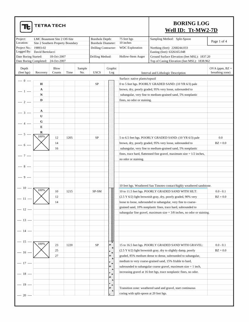
H SP 0 to 5 feet bgs. POORLY GRADED SAND: (10 YR 6/3) pale
A brown, dry, poorly graded, 95% very loose, subrounded to
N subangular, very fine to medium-grained sand, 5% nonplastic
D fines, no odor or staining.
A
U
G
E
R
12 1205 SP 5 to 6.5 feet bgs. POORLY GRADED SAND: (10 YR 6/3) pale 0.0
14 brown, dry, poorly graded, 95% very loose, subrounded to BZ = 0.0
16 subangular, very fine to medium-grained sand, 5% nonplastic
fines, trace hard, flattenned fine gravel, maximum size = 1/2 inches,
no odor or staining.
10 feet bgs. Weathered San Timoteo contact/highly weathered sandstone.
10 1215 SP-SM 10 to 11.5 feet bgs. POORLY GRADED SAND WITH SILT: 0.0 - 0.1
12 (2.5 Y 6/2) light brownish gray, dry, poorly graded, 90% very BZ = 0.0
14 loose to loose, subrounded to subangular, very fine to coarse-grained sand, 10% nonplastic fines, trace hard, subrounded to
subangular fine gravel, maximum size = 3/8 inches, no odor or staining.
23 1220 SP 15 to 16.5 feet bgs. POORLY GRADED SAND WITH GRAVEL: 0.0 - 0.1
25 (2.5 Y 6/2) light brownish gray, dry to slightly damp, poorly BZ = 0.0
27 graded, 85% medium dense to dense, subrounded to subangular,
medium to very coarse-grained sand, 15% friable to hard,
subrounded to subangular coarse gravel, maximum size = 1 inch,
increasing gravel at 16 feet bgs, trace nonplastic fines, no odor.
Transition zone: weathered sand and gravel, start continuous
coring with split-spoon at 20 feet bgs.
100%
100%
100%
LMC Beaumont Site 2 Off-Site
Date Boring Started: Date Boring Completed: 24-Oct-2007
18-Oct-2007David Bertolacci19893-02Site 2 Southern Property Boundary
---- 19 ----
---- 18 ----
---- 10 ----
---- 11 ----
---- 12 ----
---- 13 ----
---- 14 ----
---- 15 ----
---- 16 ----
---- 17 ----
---- 6 ----
---- 7 ----
---- 8 ----
---- 9 ----
---- 2 ----
---- 3 ----
---- 4 ----
---- 5 ----
BORING LOGWell ID: Tt-MW2-7D
---- 0 ----
---- 1 ----
Borehole Depth: Borehole Diameter: Drilling Contractor:
Drilling Method:
Interval and Lithologic Description
Northing (feet): 2268244.033 Easting (feet): 6326165.048 Ground Surface Elevation (feet MSL): 1837.20 Top of Casing Elevation (feet MSL): 1838.962
---- 20 ----
Page 2 of 4 Project: 75 feet bgs Sampling Method: Split-Spoon Location: 10 inches Project No.: WDC Exploration Logged By:
Hollow-Stem Auger
Depth(feet bgs) Recovery
Blow Counts Time
Sample No. USCS
Graphic Log
OVA (ppm, BZ = breathing zone)
LMC Beaumont Site 2 Off-Site
Date Boring Started: Date Boring Completed: 24-Oct-2007
18-Oct-2007David Bertolacci19893-02Site 2 Southern Property Boundary
BORING LOGWell ID: Tt-MW2-7D
Borehole Depth: Borehole Diameter: Drilling Contractor:
Drilling Method:
Interval and Lithologic Description
Northing (feet): 2268244.033 Easting (feet): 6326165.048 Ground Surface Elevation (feet MSL): 1837.20 Top of Casing Elevation (feet MSL): 1838.962
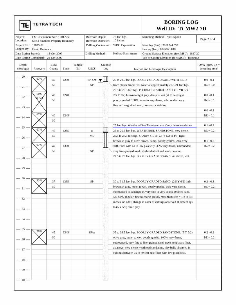
40 1230 SP-SM 20 to 20.5 feet bgs. POORLY GRADED SAND WITH SILT: 0.0 - 0.1
50 SP trace plastic fines; first water at approximately 20.5-21 feet bgs. BZ = 0.0
20.5 to 25.5 feet bgs. POORLY GRADED SAND: (10 YR 5/3 -
45 1240 2.5 Y 7/2) brown to light gray, damp to wet (at 21 feet bgs), 0.0 - 0.1
50 poorly graded, 100% dense to very dense, subrounded, very BZ = 0.1
fine to fine-grained sand, no odor or staining.
0.0 - 0.1
40 1245 BZ = 0.1
5025 feet bgs. Weathered San Timoteo contact/very dense sandstone. 0.1 - 0.2
40 1255 ss 25 to 25.5 feet bgs. WEATHERED SANDSTONE, very dense. BZ = 0.2
50 ML 25.5 to 27.5 feet bgs. SANDY SILT: (2.5 Y 6/2 to 4/3) light
brownish gray to olive brown, damp, poorly graded, 70% very 0.1 - 0.2
47 1300 stiff, fines with no to low plasticity, 30% very dense, subrounded, BZ = 0.2
50 SP very fine-grained sand,interbedded silt and sand, no odor.
27.5 to 28 feet bgs. POORLY GRADED SAND: As above, wet.
37 1335 SP 30 to 31.5 feet bgs. POORLY GRADED SAND: (2.5 Y 6/2) light 0.2 - 0.3
50 brownish gray, moist to wet, poorly graded, 95% very dense, BZ = 0.2
subrounded to subangular, very fine to very coarse-grained sand,
5% hard, angular, fine to coarse gravel, maximum size = 1/2 to 3/4
inches, no odor, change in color of cuttings observed at 30 feet bgs
to (5 Y 5/2) olive gray
45 1345 SP/ss 35 to 36.5 feet bgs: POORLY GRADED SANDSTONE: (5 Y 5/2) 0.2 - 0.3
50 olive gray, moist to wet, poorly graded, 100% very dense, BZ = 0.2
subrounded, very fine to fine-grained sand, trace nonplastic fines,
as above, very dense weathered sandstone, clay balls observed in
cuttings between 35 to 40 feet bgs (fines with low plasticity).
50%
33%
50%(1'/2')
67%
67%
67%
67%---- 20 ----
---- 21 ----
---- 26 ----
---- 27 ----
---- 24 ----
---- 25 ----
---- 22 ----
---- 23 ----
---- 30 ----
---- 31 ----
---- 28 ----
---- 29 ----
---- 34 ----
---- 35 ----
---- 32 ----
---- 33 ----
---- 38 ----
---- 39 ----
---- 36 ----
---- 37 ----
---- 40 ----

Page 3 of 4 Project: 75 feet bgs Sampling Method: Split-Spoon Location: 10 inches Project No.: WDC Exploration Logged By:
Hollow-Stem Auger
Depth(feet bgs) Recovery
Blow Counts Time
Sample No. USCS
Graphic Log
OVA (ppm, BZ = breathing zone)
LMC Beaumont Site 2 Off-Site
Date Boring Started: Date Boring Completed: 24-Oct-2007
18-Oct-2007David Bertolacci19893-02Site 2 Southern Property Boundary
BORING LOGWell ID: Tt-MW2-7D
Borehole Depth: Borehole Diameter: Drilling Contractor:
Drilling Method:
Interval and Lithologic Description
Northing (feet): 2268244.033 Easting (feet): 6326165.048 Ground Surface Elevation (feet MSL): 1837.20 Top of Casing Elevation (feet MSL): 1838.962
35 1355 SP/ss 40 to 41.5 feet bgs. POORLY GRADED SANDSTONE: ( 5 Y 5/2) 0.2
50 olive gray, moist to wet, poorly graded, 100% very dense, BZ = 0.2
subrounded, very fine to fine-grained sand, trace very stiff, low to
medium plasticity fines (as clay nodules), no odor.
Note: augers grinding and steaming.
Contact with less weathered (more competent) San Timoteoformation at approximately 45 to 50 feet bgs.
33% 100/6" 1410 ss/slst 45 to 45.5 feet bgs. SILTY SANDSTONE: (5 Y 5/1) gray, damp, 0.3
(SM) poorly graded, friable, platy bedding, 55% very dense, subrounded, BZ = 0.3
very fine-grained sand, 45% very stiff, nonplastic fines, no odor. Fresh Air
Calibration
33% 75/6" 1420 ss 50 to 50.5 fet bgs. SANDSTONE: (5 Y 6/1) gray, damp, poorly 0.0
(SP) graded, friable to very hard, 100% very dense, subrounded, very BZ = 0.0
fine to fine-grained sand, trace very stiff, nonplastic fines, no odor.
More weathered sandstone underneath less weathered sandstone.
33% 80/6" 1515 ss/slst 55 to 55.5 feet bgs. SANDSTONE WITH SILT: (5 Y 4/1) dark 0.0
(SP-SM) gray, moist, poorly graded, friable, platy bedding, 90% very BZ = 0.0
dense, subrounded, very fine to fine-grained sand, 10% very stiff,
nonplastic fines, no odor, weak cementation.
2nd Water-bearing unit encountered at approximately 59 to 60 feet bgs.
(Can hear water in borehole while pounding 60 ft sample.)
50%---- 40 ----
---- 43 ----
---- 44 ----
---- 41 ----
---- 42 ----
---- 47 ----
---- 48 ----
---- 45 ----
---- 46 ----
---- 54 ----
---- 51 ----
---- 52 ----
---- 49 ----
---- 50 ----
---- 60 ----
---- 59 ----
---- 57 ----
---- 58 ----
---- 55 ----
---- 56 ----
---- 53 ----
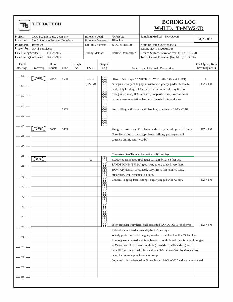
Page 4 of 4 Project: 75 feet bgs Sampling Method: Split-Spoon Location: 10 inches Project No.: WDC Exploration Logged By:
Hollow-Stem Auger
Depth(feet bgs) Recovery
Blow Counts Time
Sample No. USCS
Graphic Log
OVA (ppm, BZ = breathing zone)
LMC Beaumont Site 2 Off-Site
Date Boring Started: Date Boring Completed: 24-Oct-2007
18-Oct-2007David Bertolacci19893-02Site 2 Southern Property Boundary
BORING LOGWell ID: Tt-MW2-7D
Borehole Depth: Borehole Diameter: Drilling Contractor:
Drilling Method:
Interval and Lithologic Description
Northing (feet): 2268244.033 Easting (feet): 6326165.048 Ground Surface Elevation (feet MSL): 1837.20 Top of Casing Elevation (feet MSL): 1838.962
33% 70/6" 1550 ss/slst 60 to 60.5 feet bgs. SANDSTONE WITH SILT: (5 Y 4/1 - 3/1) 0.0
(SP-SM) dark gray to very dark gray, moist to wet, poorly graded, friable to BZ = 0.0
hard, platy bedding, 90% very dense, subrounded, very fine to
fine-grained sand, 10% very stiff, nonplastic fines, no odor, weak
to moderate cementation, hard sandstone in bottom of shoe.
1615 Stop drilling with augers at 63 feet bgs, continue on 19-Oct-2007.
18% 50/3" 0815 Slough - no recovery. Rig chatter and change in cutings to dark gray. BZ = 0.0
Note: Rock plug is causing problems drilling, pull augers and
continue drilling with 'woody.'
Competent San Timoteo formation at 68 feet bgs.
ss Recovered from bottom of auger string in bit at 68 feet bgs.
SANDSTONE: (5 Y 6/1) gray, wet, poorly graded, very hard,
100% very dense, subrounded, very fine to fine-grained sand,
micaceous, well cemented, no odor.
Continue logging from cuttings; auger plugged with 'woody.' BZ = 0.0
From cuttings: Very hard, well cemented SANDSTONE (as above). BZ = 0.0
Refusal encountered at total depth of 75 feet bgs.
Woody pushed up inside augers, knock out and build well at 74 feet bgs.
Running sands caused well to upheave in borehole and transition sand bridged
at 25 feet bgs. Abandoned borehole (too wide to drill sand out) and
backfill from bottom with Portland type II/V cement/Volclay Grout slurry
using hard-tremie pipe from bottom-up.
Step-out boring advanced to 70 feet bgs on 24-Oct-2007 and well constructed.
---- 61 ----
---- 62 ----
---- 63 ----
---- 64 ----
---- 65 ----
---- 66 ----
---- 67 ----
---- 68 ----
---- 69 ----
---- 70 ----
---- 71 ----
---- 72 ----
---- 73 ----
---- 74 ----
---- 75 ----
---- 76 ----
---- 80 ----
---- 77 ----
---- 78 ----
---- 79 ----
---- 60 ----