Embed Size (px)
Citation preview
BottineauTransitwayDRAFT ENVIRONMENTAL IMPACT STATEMENT
Scoping Booklet
Hennepin CountyRegional Railroad AuthorityMinnesota
Scoping Booklet BottineauTransitway
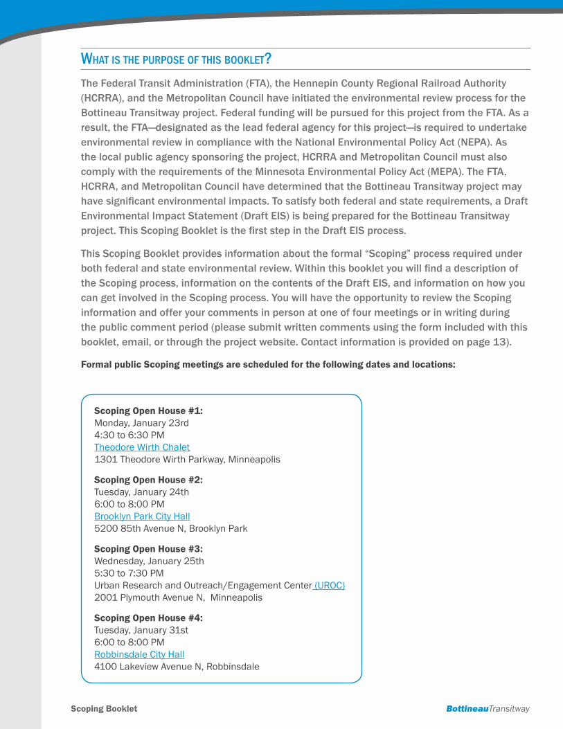
What is the purpose of this booklet?The Federal Transit Administration (FTA), the Hennepin County Regional Railroad Authority (HCRRA), and the Metropolitan Council have initiated the environmental review process for the Bottineau Transitway project. Federal funding will be pursued for this project from the FTA. As a result, the FTA—designated as the lead federal agency for this project—is required to undertake environmental review in compliance with the National Environmental Policy Act (NEPA). As the local public agency sponsoring the project, HCRRA and Metropolitan Council must also comply with the requirements of the Minnesota Environmental Policy Act (MEPA). The FTA, HCRRA, and Metropolitan Council have determined that the Bottineau Transitway project may have significant environmental impacts. To satisfy both federal and state requirements, a Draft Environmental Impact Statement (Draft EIS) is being prepared for the Bottineau Transitway project. This Scoping Booklet is the first step in the Draft EIS process.
This Scoping Booklet provides information about the formal “Scoping” process required under both federal and state environmental review. Within this booklet you will find a description of the Scoping process, information on the contents of the Draft EIS, and information on how you can get involved in the Scoping process. You will have the opportunity to review the Scoping information and offer your comments in person at one of four meetings or in writing during the public comment period (please submit written comments using the form included with this booklet, email, or through the project website. Contact information is provided on page 13).
Formal public Scoping meetings are scheduled for the following dates and locations:
Scoping Open House #1: Monday, January 23rd 4:30 to 6:30 PM Theodore Wirth Chalet 1301 Theodore Wirth Parkway, Minneapolis
Scoping Open House #2: Tuesday, January 24th 6:00 to 8:00 PM Brooklyn Park City Hall 5200 85th Avenue N, Brooklyn Park
Scoping Open House #3: Wednesday, January 25th 5:30 to 7:30 PM Urban Research and Outreach/Engagement Center (UROC) 2001 Plymouth Avenue N, Minneapolis
Scoping Open House #4: Tuesday, January 31st 6:00 to 8:00 PM Robbinsdale City Hall 4100 Lakeview Avenue N, Robbinsdale
table of Contents
What is the Bottineau Transitway? . . . . . . . . . . . . . . . . . . . . . . . . . . . . . . . . . . . . . . . . . . . . . . . . . . . . . . . . . . . . . . . . . 1
What would be built as part of the Bottineau Transitway project? . . . . . . . . . . . . . . . . . . . . . . . . . . . . . . . . . . . . . . . 1
Why is an Environmental Impact Statement (EIS) necessary? How long will the process take? . . . . . . . . . . . . . . . 2
What is Scoping? . . . . . . . . . . . . . . . . . . . . . . . . . . . . . . . . . . . . . . . . . . . . . . . . . . . . . . . . . . . . . . . . . . . . . . . . . . . . . . 2
Why Build the Bottineau Transitway? What benefits will it provide? (Project Purpose and Need) . . . . . . . . . . . . . . 2
What previous studies apply to Scoping? . . . . . . . . . . . . . . . . . . . . . . . . . . . . . . . . . . . . . . . . . . . . . . . . . . . . . . . . . . . 4
What alternatives are being considered? . . . . . . . . . . . . . . . . . . . . . . . . . . . . . . . . . . . . . . . . . . . . . . . . . . . . . . . . . . . 6
How will the alternatives be evaluated? . . . . . . . . . . . . . . . . . . . . . . . . . . . . . . . . . . . . . . . . . . . . . . . . . . . . . . . . . . . . 9
How many alternatives will be analyzed in the Draft EIS? . . . . . . . . . . . . . . . . . . . . . . . . . . . . . . . . . . . . . . . . . . . . . 9
What is the difference between the alternatives identified at the end of the Scoping process for further study in the Draft EIS and the locally preferred alternative? . . . . . . . . . . . . . . . . . . . . . . . . . . . . . . . . . . . . 10
Why does an LPA need to be identified before the EIS analysis has been completed? . . . . . . . . . . . . . . . . . . . . . . 11
What types of issues will be covered in the Draft EIS? . . . . . . . . . . . . . . . . . . . . . . . . . . . . . . . . . . . . . . . . . . . . . . . 11
How can I voice my opinion in the process? . . . . . . . . . . . . . . . . . . . . . . . . . . . . . . . . . . . . . . . . . . . . . . . . . . . . . . . 13
How will my comments be used? Will they make a difference? . . . . . . . . . . . . . . . . . . . . . . . . . . . . . . . . . . . . . . . . 14
What does the Scoping Decision Document tell us? . . . . . . . . . . . . . . . . . . . . . . . . . . . . . . . . . . . . . . . . . . . . . . . . . 14
What happens after Scoping? Can I still be involved? . . . . . . . . . . . . . . . . . . . . . . . . . . . . . . . . . . . . . . . . . . . . . . . 14
Who is involved locally in the process? . . . . . . . . . . . . . . . . . . . . . . . . . . . . . . . . . . . . . . . . . . . . . . . . . . . . . . . . . . . 14
Scoping Booklet BottineauTransitway1
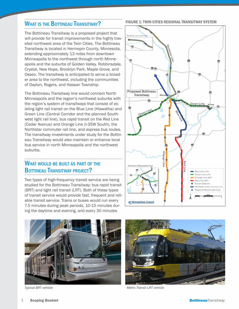
What is the bottineau transitWay?The Bottineau Transitway is a proposed project that will provide for transit improvements in the highly trav-eled northwest area of the Twin Cities . The Bottineau Transitway is located in Hennepin County, Minnesota, extending approximately 13 miles from downtown Minneapolis to the northwest through north Minne-apolis and the suburbs of Golden Valley, Robbinsdale, Crystal, New Hope, Brooklyn Park, Maple Grove, and Osseo . The transitway is anticipated to serve a broad-er area to the northwest, including the communities of Dayton, Rogers, and Hassan Township .
The Bottineau Transitway line would connect North Minneapolis and the region’s northwest suburbs with the region’s system of transitways that consist of ex-isting light rail transit on the Blue Line (Hiawatha) and Green Line (Central Corridor and the planned South-west light rail line), bus rapid transit on the Red Line (Cedar Avenue) and Orange Line (I-35W South), the Northstar commuter rail line, and express bus routes . The transitway investments under study for the Bottin-eau Transitway would also maintain or enhance local bus service in north Minneapolis and the northwest suburbs .
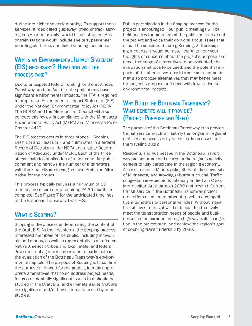
What Would be built as part of the bottineau transitWay projeCt?Two types of high-frequency transit service are being studied for the Bottineau Transitway: bus rapid transit (BRT) and light rail transit (LRT) . Both of these types of transit service would provide fast, frequent and reli-able transit service . Trains or buses would run every 7 .5 minutes during peak periods, 10-15 minutes dur-ing the daytime and evening, and every 30 minutes
0 2 4 61
Miles
St. Paul
Minneapolis
Green Line
Green Line Blue Line
Downtown Minneapolis Inset
Red
Line
Oran
ge Line
Northstar Line
Northstar Line continued
35W
35W
94
94
94
94
94
394
494
494
494
694
694
694
694
694
35E
35E
35W 35E
77
94
35W
35W
55
94
Regional Multimodal Hub
Northstar Line (commuter rail) Transit Stations Red Line (BRT)
Orange Line (BRT) Green Line (LRT) Blue Line (LRT)
Proposed Bottineau Transitway
Figure 1: Twin CiTies regional TransiTway sysTem
Typical BRT vehicle Metro Transit LRT vehicle
Scoping BookletBottineauTransitway 2
during late night and early morning . To support these services, a “dedicated guideway” (road or track serv-ing buses or trains only) would be constructed . Bus or train stations would include shelters, passenger boarding platforms, and ticket vending machines .
Why is an environmental impaCt statement (eis) neCessary? hoW long Will the proCess take?Due to anticipated federal funding for the Bottineau Transitway, and the fact that the project may have significant environmental impacts, the FTA is required to prepare an Environmental Impact Statement (EIS) under the National Environmental Policy Act (NEPA) . The HCRRA and the Metropolitan Council will also conduct this review in compliance with the Minnesota Environmental Policy Act (MEPA) and Minnesota Rules Chapter 4410 .
The EIS process occurs in three stages – Scoping, Draft EIS and Final EIS – and culminates in a federal Record of Decision under NEPA and a state Determi-nation of Adequacy under MEPA . Each of the three stages includes publication of a document for public comment and narrows the number of alternatives, with the Final EIS identifying a single Preferred Alter-native for the project .
This process typically requires a minimum of 18 months, more commonly requiring 24-36 months to complete. See Figure 7 for the anticipated timelines of the Bottineau Transitway Draft EIS .
What is sCoping? Scoping is the process of determining the content of the Draft EIS. As the first step in the Scoping process, interested members of the public, including individu-als and groups, as well as representatives of affected Native American tribes and local, state, and federal governmental agencies, are invited to participate in the evaluation of the Bottineau Transitway’s environ-mental impacts. The purpose of Scoping is to confirm the purpose and need for the project, identify appro-priate alternatives that could address project needs, focus on potentially significant issues that should be studied in the Draft EIS, and eliminate issues that are not significant and/or have been addressed by prior studies .
Public participation in the Scoping process for the project is encouraged. Four public meetings will be held to allow for members of the public to learn about the project and voice their opinions about issues that should be considered during Scoping . At the Scop-ing meetings it would be most helpful to hear your thoughts or concerns about the project’s purpose and need, the range of alternatives to be evaluated, the evaluation methods to be used, and the potential im-pacts of the alternatives considered . Your comments may also propose alternatives that may better meet the project’s purpose and need with fewer adverse environmental impacts .
Why build the bottineau transitWay? What benefits Will it provide? (projeCt purpose and need)The purpose of the Bottineau Transitway is to provide transit service which will satisfy the long-term regional mobility and accessibility needs for businesses and the traveling public .
Residents and businesses in the Bottineau Transit-way project area need access to the region’s activity centers to fully participate in the region’s economy . Access to jobs in Minneapolis, St . Paul, the University of Minnesota, and growing suburbs is crucial. Traffic congestion is expected to intensify in the Twin Cities Metropolitan Area through 2030 and beyond . Current transit service in the Bottineau Transitway project area offers a limited number of travel-time competi-tive alternatives to personal vehicles . Without major transit investments, it will be difficult to effectively meet the transportation needs of people and busi-nesses in the corridor, manage highway traffic conges-tion in the project area, and achieve the region’s goal of doubling transit ridership by 2030 .
Scoping Booklet BottineauTransitway3
Five factors contribute to the need for the Bottineau Transitway project:
h Growing travel demand
h Increasing traffic congestion
h People who depend on transit
h Limited transit service to suburban destina-tions (reverse commute opportunities) and time-efficient transit options
h Regional objectives for growth
Growing Travel Demand
Over the past two decades, the population has grown significantly in the seven-county Twin Cities Metropoli-tan Area and growth is expected to continue in the future . Between 2010 and 2030, the Metropolitan Council projects a 31% increase in the region’s popu-lation and a 32% increase in the number of jobs—meaning that approximately 900,000 new people and 650,000 new jobs would be added to the seven-county area that consists of Anoka, Carver, Dakota, Hennepin, Ramsey, Scott, and Washington counties .
Between 1990 and 2010, Bottineau Transitway com-munities such as Brooklyn Park and Maple Grove ex-perienced population increases of 34% and 59%, re-spectively; while communities also potentially served by the transitway such as Dayton, Hassan Township and Rogers, have experienced higher growth rates . In coming decades, these communities will experience the majority of growth in Hennepin County . Between 2010 and 2030, Hennepin County is projected to grow by 242,000 people . Over the same period, com-munities along the Bottineau Transitway are expected to add 140,000 people . This represents nearly 60% of Hennepin County’s total projected growth . Maple Grove and several communities to the north and west—Osseo, Dayton, and Rogers—are projected to add over 65,000 people alone, outpacing the over-all population growth rate for Hennepin County and the Twin Cities Metropolitan Area between 2010 and 2030 .
Employment in the Bottineau Transitway project area is also expected to increase in coming years . Approximately half of all jobs in the project area are located in downtown Minneapolis, which is currently the region’s largest travel demand generator; nearly
65,000 additional jobs are anticipated by 2030 . Large employment concentrations outside downtown Minneapolis are located at North Memorial Medical Center in Robbinsdale, the Target North Campus in Brooklyn Park, and at the Arbor Lakes retail complex in Maple Grove .
Growth in population and employment in the project area and beyond is expected to result in increased transportation demand. Significant growth in traf-fic volumes is anticipated within the project area, particularly in the northern suburbs of Brooklyn Park and Maple Grove, and also just beyond the transitway in Dayton. Traffic volumes are expected to increase in the range of 15 to 20 percent along project area roadways .
Increasing Traffic Congestion
Growing travel demand is expected to increase traffic congestion on the region’s highways and in down-town Minneapolis . In the past, the region responded to increased demand by constructing new roadways or expanding existing ones . In recent years, however, roadway expansion in the Twin Cities Metropolitan Area has not kept pace with mounting travel demand and is not anticipated to keep pace in the future, as growth in demand is outpacing funding . Studies at the state and regional levels have concluded that high-way expansion alone is an unsustainable approach to managing transportation demand . Instead, state and regional policy outlined in the Statewide Trans-portation Policy Plan and the 2030 Transportation Policy Plan recognizes the importance of a balanced approach to meeting travel demand that invests in maintaining the existing transportation system and favors improvement projects such as the Bottineau Transitway .
People who Depend on Transit
The Bottineau Transitway project area is home to a large number of people who depend on transit to meet their transportation needs . Based on U .S . Census information, 14% of households in the proj-ect area do not own a vehicle . This is nearly double the metropolitan area average of 8% . In some areas of north Minneapolis, the number of zero-car house-holds exceeds 50%; in areas of New Hope and Brook-lyn Park, the number exceeds 22% . The high propor-tion of people without access to vehicles underscores the need for transit access in these parts of the Bottineau Transitway project area .
Scoping BookletBottineauTransitway 4
Seniors also represent an important and growing market for public transportation . In the project area communities of Golden Valley, Robbinsdale, Crystal, and New Hope, seniors make up a larger share of the population compared to the share seniors make up of the overall regional population . Moreover, senior populations are expected to grow in Bottineau Transit-way communities in the next 20 years by as much as 125% .
Limited Transit Service to Suburban Destinations (reverse commute opportunities) and Time-Efficient Transit Options
The dominant travel pattern during morning com-mutes in the Bottineau Transitway project area today is toward downtown Minneapolis . A “reverse com-mute” pattern also exists toward Brooklyn Park, Maple Grove, and beyond into Rogers and surrounding com-munities to the north . Workers and students commute to major activity centers in the project area, such as North Memorial Medical Center in Robbinsdale, the Target North Campus, North Hennepin Community College, Hennepin Technical College in Brooklyn Park, and the Arbor Lakes retail complex in Maple Grove .
Although communities in the project area are served by a network of local and express bus routes, fast and convenient transit options to access schools and jobs in Maple Grove and Brooklyn Park are limited . Direct bus service from Minneapolis to suburban com-munities in the Bottineau corridor is provided on two limited-stop and express routes . Accessing this bus service may require a transfer in downtown, and only a few trips are available each day . However, residents of Minneapolis and the inner northwest suburbs have other transit options for accessing activity centers in the outer suburbs of Maple Grove and Brooklyn Park . Three transit centers located within the project area provide a valuable transfer point from express and urban local routes to suburban local routes . Unfortu-nately, these suburban local routes stop frequently, often require transfers, and travel at lower speeds on arterial streets, resulting in long overall travel times .
Regional Objectives for Growth
The policies guiding the development of the Twin Cities Metropolitan Area are articulated in the 2030 Regional Development Framework . Most recently updated in December 2006, the 2030 Regional Development Framework established four policies for guiding growth in the region:
h Accommodate growth in a flexible, connected and efficient manner
h Plan and invest in multi-modal transportation choices to slow the growth of traffic congestion and serve the region’s economic needs
h Encourage expanded choices in housing loca-tions and types of improved access to jobs and opportunities
h Conserve, protect and enhance the region’s vital natural resources
What previous studies apply to sCoping?Transportation and land use studies along the Bot-tineau Corridor began in 1988 with the Hennepin County Comprehensive LRT System Plan . The Bot-tineau Transitway has consistently been included in regional transportation system plans . Many different alignments (routes) and transportation modes, includ-ing BRT, LRT, and commuter rail, have been consid-ered and evaluated in plans and studies in the past . These studies provide a valuable base of information for this Draft EIS process .
Transit travel demand in the Bottineau Transitway has been consistently identified in regional transpor-tation system plans, including the Regional Transit Board LRT Plan (1990), the Transit 2020 Master Plan (2000), the 2025 Transportation Policy Plan (adopted January 2001, amended January 2002), and the 2030 Transportation Policy Plan (adopted December 2004) .
The region’s current long-range transportation plan, the 2030 Transportation Policy Plan (adopted No-vember 2010) identifies the Bottineau Transitway as one of the transit corridors to be developed by 2030 . The recommendation for the Bottineau Transitway is based on findings from the Metropolitan Council’s 2030 Transit Master Study (2008) .
Bottineau Transitway Alternatives Analysis Study, March 2010
The HCRRA, in partnership with the Metropolitan Council, Maple Grove Transit, the Minnesota Depart-ment of Transportation (MnDOT), and the cities of Minneapolis, Golden Valley, Robbinsdale, Crystal, New Hope, Brooklyn Park, Maple Grove and Osseo, recently completed an Alternatives Analysis (AA) study for the Bottineau Transitway . The Bottineau Transitway AA study evaluated a wide range of transit modes and
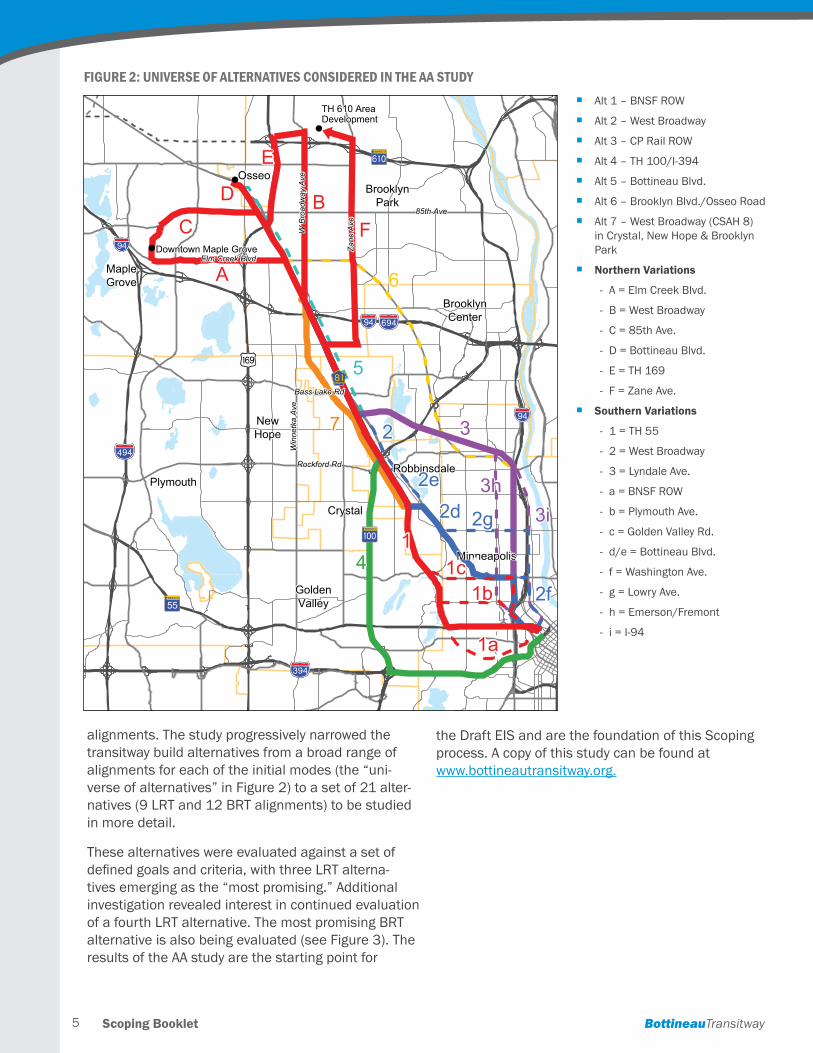
Scoping Booklet BottineauTransitway5
alignments . The study progressively narrowed the transitway build alternatives from a broad range of alignments for each of the initial modes (the “uni-verse of alternatives” in Figure 2) to a set of 21 alter-natives (9 LRT and 12 BRT alignments) to be studied in more detail .
These alternatives were evaluated against a set of defined goals and criteria, with three LRT alterna-tives emerging as the “most promising .” Additional investigation revealed interest in continued evaluation of a fourth LRT alternative . The most promising BRT alternative is also being evaluated (see Figure 3). The results of the AA study are the starting point for
the Draft EIS and are the foundation of this Scoping process . A copy of this study can be found at www .bottineautransitway .org .
Figure 2: universe oF alTernaTives Considered in The aa sTudy
Alternatives Analysis StudyBottineauTransitwayHennepin County
Regional Railroad AuthorityHennepin CountyRegional Railroad Authority
Stage 2: Universe of Bus Rapid Transit (BRT) and Light Rail Transit (LRT)Alternatives
!"b$
%&f(
%&h(
)y
?óA@
%&e(
?úA@
!"b$
!"b$
GÛWX
?ØA@
85th Ave
W B
road
way
Ave
Elm Creek Blvd
85th Ave
W B
road
way
Ave
Elm Creek Blvd
Bass Lake RdBass Lake Rd
Rockford RdRockford Rd
Zan
e A
veZ
ane
Ave
Win
netk
a A
veW
inne
tka
Ave
MapleGrove
BrooklynPark
Crystal
NewHope
Robbinsdale
Minneapolis
BrooklynCenter
Plymouth
GoldenValley
Osseo
Downtown Maple Grove
MapleGrove
BrooklynPark
Crystal
NewHope
Robbinsdale
Minneapolis
BrooklynCenter
Plymouth
GoldenValley
Osseo
Downtown Maple Grove!
!
!
TH 610 AreaDevelopmentTH 610 AreaDevelopment
A
BC
D
E
3
2d
1
1a
1b1c
2e
2
2f
2g
3h
4
3i
A
BC
D
E
3
2d
1
1a
1b1c
2e
2
2f
2g
3h
4
3i
6
5
7
6
5
7
FF
• Alt1–BNSFROW
• Alt2–WBroadway
• Alt3–CPRailROW
• Alt4–TH100/I-394
• Alt5–BottineauBoulevard
• Alt6–BrooklynBoulevard/OsseoRoad
• Alt7–WBroadwayAvenue(CSAH8) inCrystal,NewHope&BrooklynPark
•Northern variations - A=ElmCreek Boulevard
- B=WestBroadway Avenue
- C=85thAvenue
- D=Bottineau Boulevard
- E=TH169
- F=ZaneAvenue
•Southern variations - 1=TH55
- 2=WestBroadway
- 3=LyndaleAvenue
- a=BNSFROW
- b=PlymouthAvenue
- c=GoldenValleyRoad
- d/e=BottineauBoulevard
- f= WashingtonAvenue
- g=LowryAvenue
- h=Emerson/Fremont
- i= I-94
h Alt 1 – BNSF ROW
h Alt 2 – West Broadway
h Alt 3 – CP Rail ROW
h Alt 4 – TH 100/I-394
h Alt 5 – Bottineau Blvd .
h Alt 6 – Brooklyn Blvd ./Osseo Road
h Alt 7 – West Broadway (CSAH 8) in Crystal, New Hope & Brooklyn Park
h Northern Variations
- A = Elm Creek Blvd .
- B = West Broadway
- C = 85th Ave .
- D = Bottineau Blvd .
- E = TH 169
- F = Zane Ave.
h Southern Variations
- 1 = TH 55
- 2 = West Broadway
- 3 = Lyndale Ave .
- a = BNSF ROW
- b = Plymouth Ave .
- c = Golden Valley Rd .
- d/e = Bottineau Blvd .
- f = Washington Ave .
- g = Lowry Ave .
- h = Emerson/Fremont
- i = I-94
Scoping BookletBottineauTransitway 6
What alternatives are being Considered? The Draft EIS will evaluate a No-Build alternative, an Enhanced Bus/Transportation System Management (TSM) alternative, and several Build alternatives . The Build alternatives being considered for further study in the Draft EIS (four LRT and one BRT) are the most promising alternatives identified during the AA study.
No-Build Alternative
The No-Build alternative serves as the baseline against which environmental effects of the Bottineau Transitway alternatives are measured .
The No-Build alternative is defined as the existing transportation system, plus any committed transpor-tation improvements in the region . Committed trans-portation improvements include roadway and transit facility and service improvements (not including the Bottineau Transitway) planned, programmed, and included in the TPP to be implemented by the year 2030. Major regional transit projects (shown in Figure 1) are included in the No-Build alternative .
Enhanced Bus/Transportation Systems Management (TSM) Alternative
The TSM alternative is defined as enhancements and upgrades to the existing transportation system in the project corridor, attempting to meet the project’s pur-pose and need as much as possible without a major capital investment . The TSM alternative could include bus route restructuring, scheduling improvements, new express and limited-stop services, intersection improvements, and/or other focused infrastructure improvements that would improve the function of the transit system. The specific combination of improve-ments to be incorporated into the TSM alternative will be developed during the Draft EIS process .
In addition to the No-Build and TSM alternatives, the following Build alternatives are proposed for inclusion in the Draft EIS:
Light Rail Transit (LRT) Alternatives
LRT alternatives proposed for study include several stations between downtown Minneapolis and the Ma-ple Grove/Brooklyn Park area . Each LRT alternative would include tracks, stations, and support facilities, as well as transit service for LRT and connecting bus routes . The four LRT alternatives under consideration
for more detailed study in the Draft EIS consist of the north (Alignments A and B) and south alignment alternatives (Alignments D1 and D2) connected by the central alignment C .
h A-C-D1
h A-C-D2
h B-C-D1
h B-C-D2
Northern variations (alignments):
At the north end of the corridor, there are two align-ment options:
h Alignment A originates in Maple Grove at Hemlock Lane/Arbor Lakes Parkway, and follows the future Arbor Lakes Parkway and Elm Creek Boulevard to the BNSF railroad corridor located on the west side of Bottineau Boulevard .
h Alignment B begins at the Target North Campus (located just north of Highway 610), follows West Broadway Avenue, and crosses Bottineau Boule-vard at 73rd Avenue to enter the BNSF railroad corridor .
Center segment:
Both the A and B alignments would transition to the C alignment in the BNSF railroad corridor on the west side of Bottineau Boulevard through southern Brook-lyn Park, Crystal, and Robbinsdale .
Southern variations (alignments):
There are two alignments under consideration for the transitway south of 36th Avenue in Robbinsdale and into downtown Minneapolis:
h Alignment D1 continues along the BNSF railroad corridor to Olson Memorial Highway, and then fol-lows Olson Memorial Highway to downtown .
h Alignment D2 exits the railroad corridor near 34th Avenue, joins West Broadway Avenue, and travels on Penn Avenue to Olson Memorial Highway and into downtown .
Scoping Booklet BottineauTransitway7
Figure 3: Build alTernaTives ProPosed For sTudy in The draFT eisN
orthstar Comm
uter Rail
Hiawatha LRT
A
B
D1
D2
Southwest LRT
C
Blaine
BrooklynCenter
ColumbiaHeights
CoonRapids
Fridley
Hilltop
MedicineLake
Minnetonka
Plymouth
SpringLakePark
BrooklynPark
Crystal
GoldenValley
New Hope
Osseo
Robbinsdale
Minneapolis
MapleGrove
94394
394
694
394
94
10
169
169
610
100
55
55
55
252
100
71st Avenue (A
only)
Golden
Valley Road
Penn Avenue
Zachary Lane
Hemlo
ck
Lane
Boone Avenue/ H
enn Tech
The Inte
rchange
97th A
venue
93rd A
venue
85th A
venue
Brooklyn Boule
vard
63rd A
venue
Bass Lake Road
Robbinsdale
North M
emoria
l
Broadway/P
enn
Plymouth
Avenue
Van White
0 1 20.5Miles
Alignment and station alternatives
A (Maple Grove)
B (Brooklyn Park)
C (common segment)
D1 (BNSF Railway-Olson Highway)
D2 (West Broadway-Penn Avenue)
D1-D2 (common segment)
Border A
venue
Marquette/5th
Marquette/7th
Marquette/9th
Marquette/11th2nd Ave/11th
2nd Ave/9th
2nd Ave/7th
2nd Ave/5th
4th/Hennepin
10th St S
2nd
Ave
S
W Linden St
3rd Ave
N
12th St N
9th
S t N
16th
S t N
2nd Ave N7th St N
9th St S
Hennepin Ave
2nd St S
7th St S
1st Ave
N 4th St S
8th St S
Yale Pl
Roya
lsto
n A
ve N 1st St S
6th Ave N
94
394
94
394
55
* Leamington Ramp
Hiawatha
0 0.2 0.40.1Miles
BRT ALIGNMENT INDOWNTOWN MINNEAPOLIS
See inset forBRT routing
Scoping BookletBottineauTransitway 8
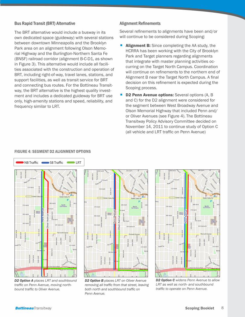
Bus Rapid Transit (BRT) Alternative
The BRT alternative would include a busway in its own dedicated space (guideway) with several stations between downtown Minneapolis and the Brooklyn Park area on an alignment following Olson Memo-rial Highway and the Burlington-Northern Santa Fe (BNSF) railroad corridor (alignment B-C-D1, as shown in Figure 3). This alternative would include all facili-ties associated with the construction and operation of BRT, including right-of-way, travel lanes, stations, and support facilities, as well as transit service for BRT and connecting bus routes. For the Bottineau Transit-way, the BRT alternative is the highest quality invest-ment and includes a dedicated guideway for BRT use only, high-amenity stations and speed, reliability, and frequency similar to LRT .
Alignment Refinements
Several refinements to alignments have been and/or will continue to be considered during Scoping:
h Alignment B: Since completing the AA study, the HCRRA has been working with the City of Brooklyn Park and Target planners regarding alignments that integrate with master planning activities oc-curring on the Target North Campus . Coordination will continue on refinements to the northern end of Alignment B near the Target North Campus. A final decision on this refinement is expected during the Scoping process .
h D2 Penn Avenue options: Several options (A, B and C) for the D2 alignment were considered for the segment between West Broadway Avenue and Olson Memorial Highway that included Penn and/or Oliver Avenues (see Figure 4). The Bottineau Transitway Policy Advisory Committee decided on November 14, 2011 to continue study of Option C (all vehicle and LRT traffic on Penn Avenue)
0 900450FeetN
Penn
Ave
nue
Oliv
er A
venu
e
Penn
Ave
nue
Oliv
er A
venu
eO
liver
Ave
nue
D2 Option B places LRT on Oliver Avenue removing all traffic from that street, leaving both north and southbound traffic on Penn Avenue.
D2 Option A places LRT and southbound traffic on Penn Avenue, moving north-bound traffic to Oliver Avenue.
Penn
Ave
nue
Oliv
er A
venu
e
Penn
Ave
nue
Oliv
er A
venu
eO
liver
Ave
nue
0 900450FeetN
Figure 4: segmenT d2 alignmenT oPTions
0 900450FeetN
Penn
Ave
nue
Penn
Ave
nue
D2 Option C widens Penn Avenue to allow LRT as well as north- and southbound traffic to operate on Penn Avenue.
NB Traffic SB Traffic LRT
Scoping Booklet BottineauTransitway9
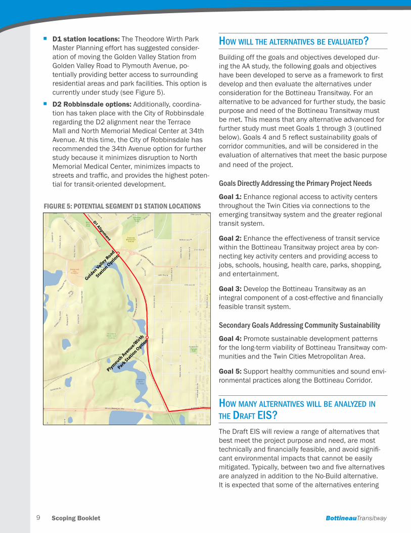
h D1 station locations: The Theodore Wirth Park Master Planning effort has suggested consider-ation of moving the Golden Valley Station from Golden Valley Road to Plymouth Avenue, po-tentially providing better access to surrounding residential areas and park facilities . This option is currently under study (see Figure 5).
h D2 Robbinsdale options: Additionally, coordina-tion has taken place with the City of Robbinsdale regarding the D2 alignment near the Terrace Mall and North Memorial Medical Center at 34th Avenue . At this time, the City of Robbinsdale has recommended the 34th Avenue option for further study because it minimizes disruption to North Memorial Medical Center, minimizes impacts to streets and traffic, and provides the highest poten-tial for transit-oriented development .
hoW Will the alternatives be evaluated?Building off the goals and objectives developed dur-ing the AA study, the following goals and objectives have been developed to serve as a framework to first develop and then evaluate the alternatives under consideration for the Bottineau Transitway. For an alternative to be advanced for further study, the basic purpose and need of the Bottineau Transitway must be met . This means that any alternative advanced for further study must meet Goals 1 through 3 (outlined below). Goals 4 and 5 reflect sustainability goals of corridor communities, and will be considered in the evaluation of alternatives that meet the basic purpose and need of the project .
Goals Directly Addressing the Primary Project Needs
Goal 1: Enhance regional access to activity centers throughout the Twin Cities via connections to the emerging transitway system and the greater regional transit system .
Goal 2: Enhance the effectiveness of transit service within the Bottineau Transitway project area by con-necting key activity centers and providing access to jobs, schools, housing, health care, parks, shopping, and entertainment .
Goal 3: Develop the Bottineau Transitway as an integral component of a cost-effective and financially feasible transit system .
Secondary Goals Addressing Community Sustainability
Goal 4: Promote sustainable development patterns for the long-term viability of Bottineau Transitway com-munities and the Twin Cities Metropolitan Area .
Goal 5: Support healthy communities and sound envi-ronmental practices along the Bottineau Corridor .
hoW many alternatives Will be analyzed in the draft eis? The Draft EIS will review a range of alternatives that best meet the project purpose and need, are most technically and financially feasible, and avoid signifi-cant environmental impacts that cannot be easily mitigated. Typically, between two and five alternatives are analyzed in addition to the No-Build alternative . It is expected that some of the alternatives entering
Figure 5: PoTenTial segmenT d1 sTaTion loCaTions
Scoping BookletBottineauTransitway 10
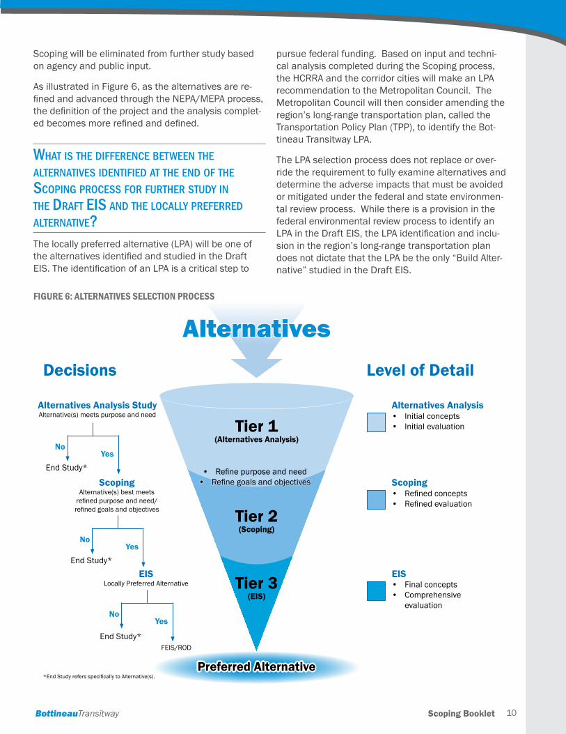
Scoping will be eliminated from further study based on agency and public input .
As illustrated in Figure 6, as the alternatives are re-fined and advanced through the NEPA/MEPA process, the definition of the project and the analysis complet-ed becomes more refined and defined.
What is the differenCe betWeen the alternatives identified at the end of the sCoping proCess for further study in the draft eis and the loCally preferred alternative?The locally preferred alternative (LPA) will be one of the alternatives identified and studied in the Draft EIS. The identification of an LPA is a critical step to
pursue federal funding . Based on input and techni-cal analysis completed during the Scoping process, the HCRRA and the corridor cities will make an LPA recommendation to the Metropolitan Council . The Metropolitan Council will then consider amending the region’s long-range transportation plan, called the Transportation Policy Plan (TPP), to identify the Bot-tineau Transitway LPA .
The LPA selection process does not replace or over-ride the requirement to fully examine alternatives and determine the adverse impacts that must be avoided or mitigated under the federal and state environmen-tal review process . While there is a provision in the federal environmental review process to identify an LPA in the Draft EIS, the LPA identification and inclu-sion in the region’s long-range transportation plan does not dictate that the LPA be the only “Build Alter-native” studied in the Draft EIS .
AlternativesDecisions Level of Detail
• Initialconcepts• Initialevaluation
• Refinedconcepts• Refinedevaluation
• Finalconcepts• Comprehensive
evaluation
Tier 1(Alternatives Analysis)
Tier 2(Scoping)
Tier 3(EIS)
Alternatives Analysis StudyAlternative(s)meetspurposeandneed
ScopingAlternative(s)bestmeetsrefinedpurposeandneed/refinedgoalsandobjectives
FEIS/ROD
EISLocallyPreferredAlternative
EndStudy*
EndStudy*
EndStudy*
No
No
No
Yes
Yes
Yes
• Refinepurposeandneed• Refinegoalsandobjectives
Preferred Alternative
Alternatives Analysis
Scoping
EIS
*EndStudyrefersspecificallytoAlternative(s).
Figure 6: alTernaTives seleCTion ProCess
Scoping Booklet BottineauTransitway11
Why does an lpa need to be identified before the eis analysis has been Completed?The identification of an LPA is a critical step to pursue federal funding . The selection of an LPA for the Bot-tineau Transitway marks the end of the Alternatives Analysis phase . Concluding the AA process allows the project to pursue federal funding . The public input received during Scoping along with the analysis con-ducted during the Scoping process will inform the LPA decision-making .
What types of issues Will be Covered in the draft eis? The Draft EIS provides an opportunity for the public and agencies to disclose and explore anticipated project impacts . The Draft EIS will evaluate existing conditions and the significant potential impacts of the No-Build, TSM and Build alternatives on the environ-ment . Environmental effects to be analyzed in the Draft EIS will include:
h Neighborhood and community resources: Effects on neighborhoods, social groups, community facili-ties, and community cohesion in the project area .
h Environmental justice: Effects of the proposed al-ternatives on minority and low-income populations and communities .
h Noise and vibration: Effects on noise and vibra-tion on sensitive properties .
h Historic and cultural resources (Section 106 pro-cess): Effects on historic and cultural resources that include historic districts, buildings, structures, and other objects included in, or eligible for inclu-sion in the National Register of Historic Places .
h Parks and public land (Section 4(f) and 6(f)): Ef-fects on publicly owned parks and recreation lands within the project area .
h Water resources, wetlands, and habitat: Ef-fects on water resources, including surface water resources, water quality, wetlands, floodplains, critical areas, and groundwater . It also considers effects on ecosystems and protected plant and animal species .
h Air quality and climate change: Effects on climate change and regional air quality .
Other potential impacts to be addressed in the Draft EIS include:
h Land use and zoning
h Consistency with local plans
h Right-of-way impacts
h Economic development and redevelopment
h Visual and aesthetics
h Transportation (including transit, roads and high-ways, railroads and pedestrian/bicycle facilities)
h Safety and security
h Hazardous material/contamination
h Soils and geologic resources
h Utilities
h Energy
h Secondary and cumulative effects
During the EIS process, refined capital cost estimates will also be prepared, along with operating and main-tenance cost estimates, and ridership forecasts .
The schedule for the Draft EIS is shown in Figure 7.
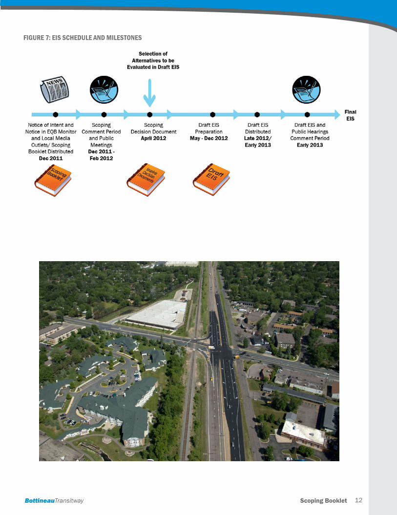
Scoping BookletBottineauTransitway 12
Figure 7: eis sChedule and milesTones
Scoping Booklet BottineauTransitway13
hoW Can i voiCe my opinion in the proCess? Anyone interested in the Bottineau Transitway project is encouraged to take part in the Scoping process . Project planners are especially interested in your input on:
h Purpose and need for the project
h The alternatives proposed for study
h Project impacts or benefits that should be evaluated
There are several ways for you to participate and for your voice to be heard .
You can attend a meeting to learn more about the Scoping process and to share your thoughts about the project .
Formal public Scoping meetings are scheduled for the following dates and locations:
You can submit comments in writing, by U.S. mail, e-mail, or fax, to:
Brent Rusco Bottineau Transitway Project Manager Hennepin County 701 Fourth Avenue South, Suite 400 Minneapolis, MN 55415
Phone: 612 .543 .0579 Email: brent .rusco@co .hennepin .mn .us Fax: 612.348.9710
For your convenience, a public comment sheet is in-cluded with this booklet . Comments may also be sub-mitted directly via the Bottineau Transitway website, www .bottineautransitway .org .
The scoping period closes on February 17, 2012. All comments must be received by that date.
Government agencies will be invited to a separate interagency Scoping meeting to be held as follows:
Interagency Meeting: Date: Thursday, January 19 Time: 9:00 to 11:00 AM
Auxiliary aides, services and communication materi-als in accessible formats and languages other than English can be provided if notice is given at least 14 calendar days before the meeting by contacting Brent Rusco at the address, telephone number, or e-mail address above .
Written materials, project updates, and materials used at the public Scoping meetings will be available on the Bottineau Transitway project website: www .bottineautransitway .org .
Scoping Open House #1: Monday, January 23rd 4:30 to 6:30 PM Theodore Wirth Chalet 1301 Theodore Wirth Parkway, Minneapolis
Scoping Open House #2: Tuesday, January 24th 6:00 to 8:00 PM Brooklyn Park City Hall 5200 85th Avenue N, Brooklyn Park
Scoping Open House #3: Wednesday, January 25th 5:30 to 7:30 PM Urban Research and Outreach/Engagement Center (UROC) 2001 Plymouth Avenue N, Minneapolis
Scoping Open House #4: Tuesday, January 31st 6:00 to 8:00 PM Robbinsdale City Hall 4100 Lakeview Avenue N, Robbinsdale
Scoping BookletBottineauTransitway 14
hoW Will my Comments be used? Will they make a differenCe? Your comments can make a difference . Comments received during the Scoping period will be used to finalize the Bottineau Transitway purpose and need, refine the proposed alternatives, and identify envi-ronmental topic areas to be analyzed in the Draft EIS and their method of analysis. You can find out how all comments were addressed by reviewing the Scoping Decision Document, which is a summary of the Scop-ing process, comments received, and response to comments that is published after the Scoping public comment period ends . This report will be made avail-able to the public and interested agencies .
What does the sCoping deCision doCument tell us?The Scoping Decision Document is a summary of the Scoping process, comments received, and responses to comments, published after the Scoping public comment period ends . It tells how comments received during the Scoping process were addressed and pres-ents the final Bottineau Transitway purpose and need, the alternatives to be studied, and the environmental topic areas and the methods of analysis in the Draft EIS .
What happens after sCoping? Can i still be involved? The Scoping process is just the beginning of the environmental review process . Although the formal Scoping period ends on February 17, 2012, opportu-nities for involvement in the Draft EIS will continue . Additional community meetings will be scheduled dur-ing the preparation of the Draft EIS and materials will be posted to the project website for community review and comments .
Following publication of the Draft EIS another series of formal public hearings will be conducted to receive your comments on the findings of the Draft EIS and the recommendation for the preferred alternative .
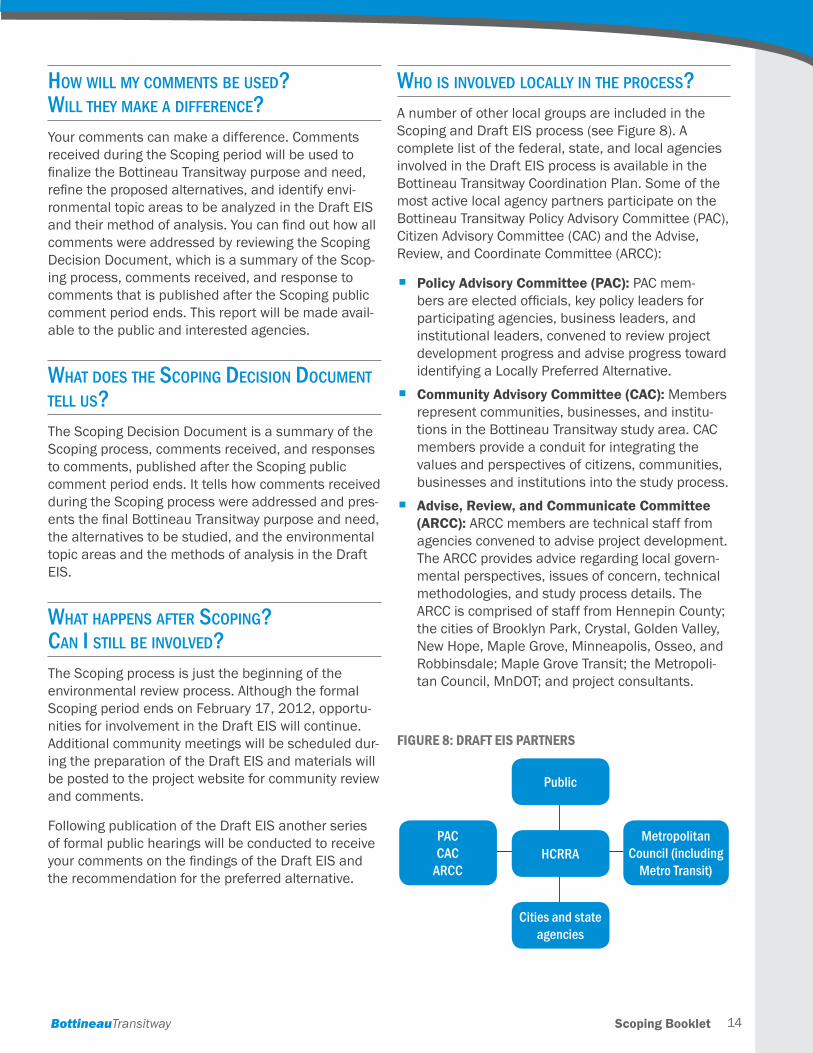
Who is involved loCally in the proCess? A number of other local groups are included in the Scoping and Draft EIS process (see Figure 8). A complete list of the federal, state, and local agencies involved in the Draft EIS process is available in the Bottineau Transitway Coordination Plan . Some of the most active local agency partners participate on the Bottineau Transitway Policy Advisory Committee (PAC), Citizen Advisory Committee (CAC) and the Advise, Review, and Coordinate Committee (ARCC):
h Policy Advisory Committee (PAC): PAC mem-bers are elected officials, key policy leaders for participating agencies, business leaders, and institutional leaders, convened to review project development progress and advise progress toward identifying a Locally Preferred Alternative .
h Community Advisory Committee (CAC): Members represent communities, businesses, and institu-tions in the Bottineau Transitway study area . CAC members provide a conduit for integrating the values and perspectives of citizens, communities, businesses and institutions into the study process .
h Advise, Review, and Communicate Committee (ARCC): ARCC members are technical staff from agencies convened to advise project development . The ARCC provides advice regarding local govern-mental perspectives, issues of concern, technical methodologies, and study process details . The ARCC is comprised of staff from Hennepin County; the cities of Brooklyn Park, Crystal, Golden Valley, New Hope, Maple Grove, Minneapolis, Osseo, and Robbinsdale; Maple Grove Transit; the Metropoli-tan Council, MnDOT; and project consultants .
Figure 8: draFT eis ParTners
Public
HCRRAMetropolitan
Council (including Metro Transit)
PAC CAC
ARCC
Cities and state agencies
list of aCronyms:AA . . . . . . . . . . . . . Alternatives Analysis
ARCC . . . . . . . . . . . Advise, Review, and Coordinate Committee
BNSF . . . . . . . . . . . Burlington-Northern Santa Fe (railroad)
BRT . . . . . . . . . . . . Bus Rapid Transit
CAC . . . . . . . . . . . . Citizen Advisory Committee
EIS . . . . . . . . . . . . . Environmental Impact Statement
FTA . . . . . . . . . . . . . Federal Transit Administration
HCRRA . . . . . . . . . . Hennepin County Regional Railroad Authority
LPA . . . . . . . . . . . . Locally Preferred Alternative
LRT . . . . . . . . . . . . Light Rail Transit
MEPA . . . . . . . . . . . Minnesota Environmental Policy Act
MnDOT . . . . . . . . . Minnesota Department of Transportation
NEPA . . . . . . . . . . . National Environmental Policy Act
PAC . . . . . . . . . . . . Policy Advisory Committee
TPP . . . . . . . . . . . . Transportation Policy Plan
TSM . . . . . . . . . . . . Transportation System Management
regional Color-Coded transit lines:Blue Line . . . . . . . . Hiawatha LRT (In Operation)
Green Line . . . . . . Central Corridor (In Construction) and Southwest LRT (Preliminary Engineering)
Orange Line . . . . . I-35W South BRT (Preliminary Engineering)
Red Line . . . . . . . . Cedar Ave BRT (In Construction)
Scoping BookletBottineauTransitway
notes
_____________________________________________________________________________________________
_____________________________________________________________________________________________
_____________________________________________________________________________________________
_____________________________________________________________________________________________
_____________________________________________________________________________________________
_____________________________________________________________________________________________
_____________________________________________________________________________________________
_____________________________________________________________________________________________
_____________________________________________________________________________________________
_____________________________________________________________________________________________
_____________________________________________________________________________________________
_____________________________________________________________________________________________
_____________________________________________________________________________________________
_____________________________________________________________________________________________
_____________________________________________________________________________________________
_____________________________________________________________________________________________
_____________________________________________________________________________________________
_____________________________________________________________________________________________
_____________________________________________________________________________________________
_____________________________________________________________________________________________
_____________________________________________________________________________________________
_____________________________________________________________________________________________
_____________________________________________________________________________________________
_____________________________________________________________________________________________
_____________________________________________________________________________________________
_____________________________________________________________________________________________
_____________________________________________________________________________________________

SCOPING BOOKLET | December, 2011
Prepared for Hennepin County Regional Railroad Authority by Kimley-Horn and SRF Consulting Group, Inc.
BottineauTransitwayDRAFT ENVIRONMENTAL IMPACT STATEMENT