Embed Size (px)
Citation preview
Bottle Lake Forest Park and the Burwood Resource Recovery Park
An area of the central Bottle Lake Forest Park is being used for the Burwood Resource Recovery Park operation following the February 22 earthquake. Rubble and silt from the earthquake is being recycled at the park.
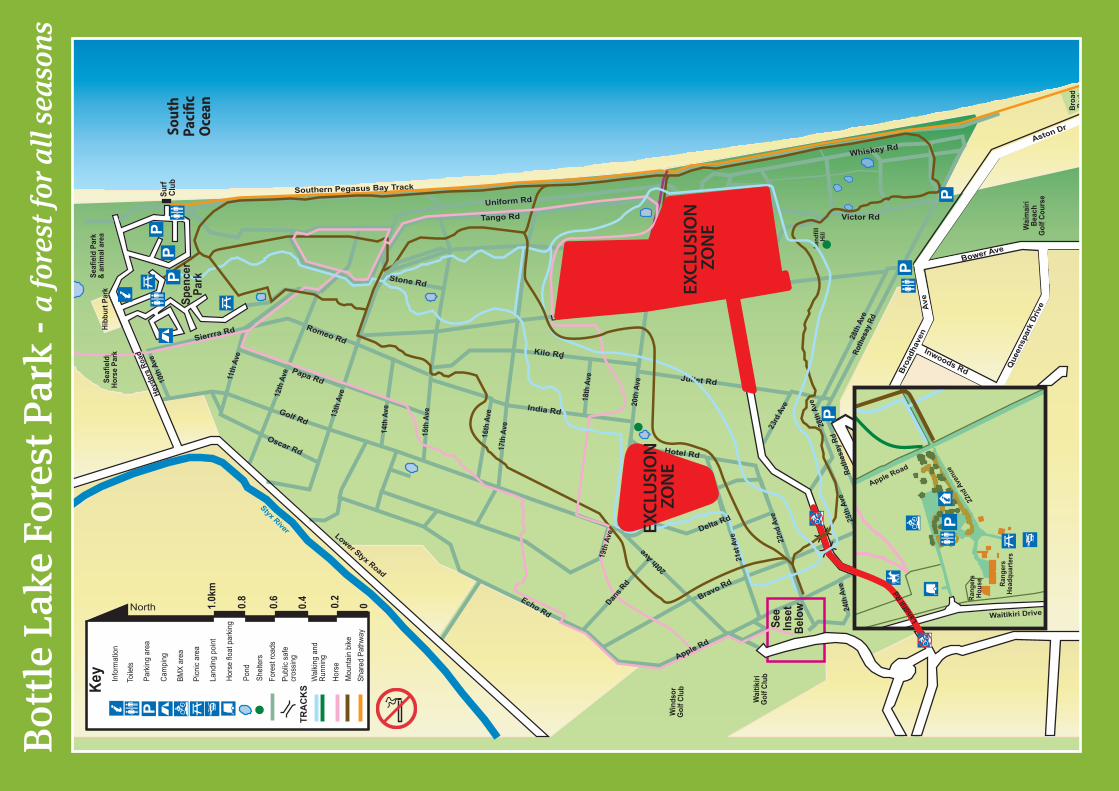
A number of tracks have been re-routed and an exclusion area is in place for public health and safety. Closed tracks and roads are clearly signposted and barricaded for the safety of the public. All park users should be aware that heavy vehicles are using park roads, seven days per week, to access the Resource Recovery area and visitors should exercise extra caution at all times.
To reduce congestion, travel time and distance, trucks are using two additional entrances to the resource recovery park, via Bower Avenue and Putake Drive in Tumara Park, as well as the normal Landfill Road entrance.
Park Rangers and security staff are patrolling the park and only authorised vehicles are allowed to enter the forest road at all times.
Recreational Opportunities
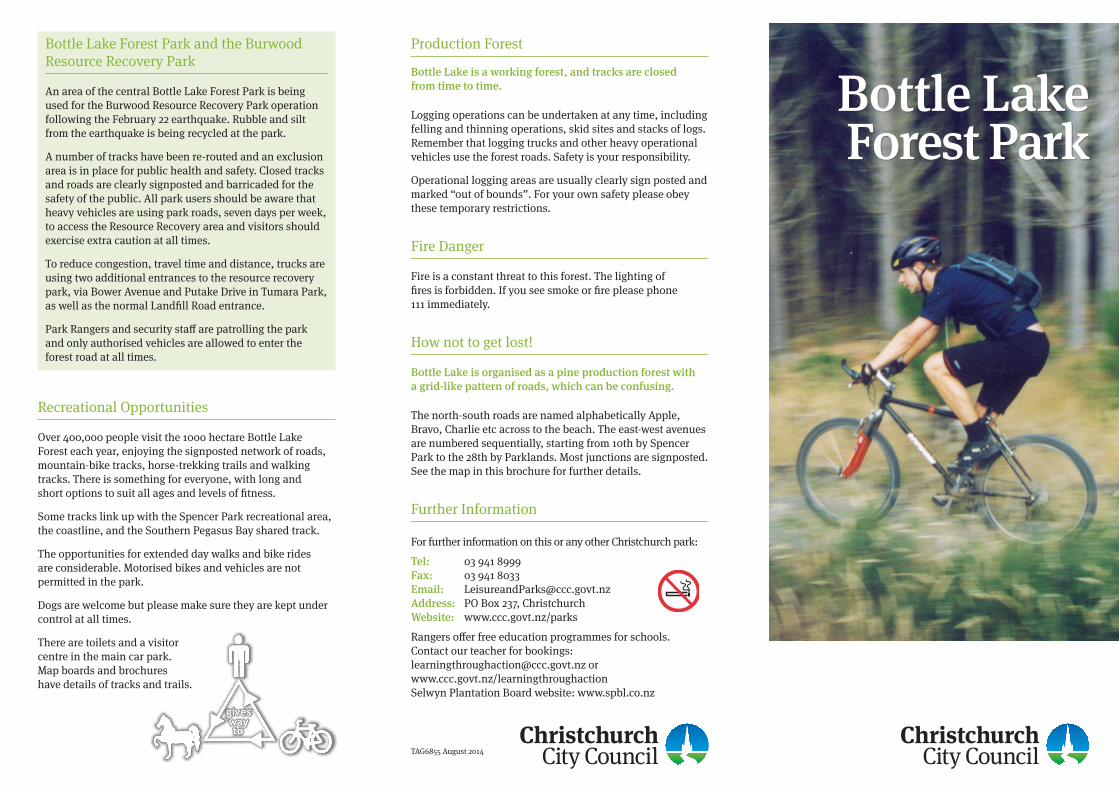
Over 400,000 people visit the 1000 hectare Bottle Lake Forest each year, enjoying the signposted network of roads, mountain-bike tracks, horse-trekking trails and walking tracks. There is something for everyone, with long and short options to suit all ages and levels of fitness.
Some tracks link up with the Spencer Park recreational area, the coastline, and the Southern Pegasus Bay shared track.
The opportunities for extended day walks and bike rides are considerable. Motorised bikes and vehicles are not permitted in the park.
Dogs are welcome but please make sure they are kept under control at all times.
There are toilets and a visitor centre in the main car park. Map boards and brochures have details of tracks and trails.
Bottle Lake is a working forest, and tracks are closed from time to time.
Logging operations can be undertaken at any time, including felling and thinning operations, skid sites and stacks of logs. Remember that logging trucks and other heavy operational vehicles use the forest roads. Safety is your responsibility.
Operational logging areas are usually clearly sign posted and marked “out of bounds”. For your own safety please obey these temporary restrictions.
Fire Danger
Fire is a constant threat to this forest. The lighting of fires is forbidden. If you see smoke or fire please phone 111 immediately.
How not to get lost!
Bottle Lake is organised as a pine production forest with a grid-like pattern of roads, which can be confusing.
The north-south roads are named alphabetically Apple, Bravo, Charlie etc across to the beach. The east-west avenues are numbered sequentially, starting from 10th by Spencer Park to the 28th by Parklands. Most junctions are signposted. See the map in this brochure for further details.
Further Information For further information on this or any other Christchurch park:
Tel: 03 941 8999 Fax: 03 941 8033 Email: [email protected] Address: PO Box 237, Christchurch Website: www.ccc.govt.nz/parks
Rangers offer free education programmes for schools. Contact our teacher for bookings: [email protected] or www.ccc.govt.nz/learningthroughaction Selwyn Plantation Board website: www.spbl.co.nz
Production Forest
Forest ParkBottle Lake
TAG6855 August 2014
Seaf
ield
Par
k &
anim
al a
rea
Hibb
urt P
ark
Wai
mai
ri Be
ach
Gol
f Cou
rse
Burwood Road
Wai
tikiri
G
olf C
lub
Win
dsor
Gol
f Clu
b
Surf
Club
Sout
h Pa
ci�c
O
cean
Styx River
Land
fill A
ve
24th
Ave
Roth
esay
Rd
Bravo Rd
Romeo Rd
Golf Rd
Oscar Rd
11th
Ave
15th
Ave
16th
Ave
17th
Ave14
th A
ve13th
Ave
India Rd
Kilo Rd
Victor Rd
Whiskey Rd
10th
Ave
12th
Ave
Echo Rd
Lower Styx Road
28th
Ave
Tango RdUniform RdSp
ence
r Pa
rk
Ave
Broa
dhav
en
Inwoods Road
Bower Ave
Roth
esay
Rd
PP
P
25th
Ave
Waitikiri Drive
28th
Ave
Southern Pegasus Bay Track
Stone Rd
Papa RdSeaf
ield
Ho
rse
Park
Sierrra Rd
Land
fill A
ve
Heyd
ers
Road
Ave
Inwoods Rd Bro
adha
ven
Que
ensp
ark
Driv
e
Broa
dPa
rk
Burwood Rd
See
Inse
tBe
low
Mou
ntai
n bi
keHo
rse
Shar
ed P
athw
ay
Key
North 00.2
0.4
0.6
0.8
1.0k
m
Pond
Info
rmat
ion
Toile
ts
Park
ing
area
Cam
ping
Hors
e flo
at p
arkin
g
BMX
area
Fore
st ro
ads
Publ
ic sa
fe
cros
sing
Wal
king
and
Runn
ing
TRA
CK
S
Shel
ters
P
P
Land
fill
Hill
Aston Dr
P
20th Ave
Apple Road
22nd
Ave
nue
Rang
ers
Head
quar
ters
Rang
ers
Hous
e
Waitikiri Drive
P
Juliet Rd
Land
fill S
iteNo
Ent
ry
Hotel Rd
18th
Ave
23rd
Ave
November Rd
Lima Rd
20th
Ave
Foxtrot Rd
Delta Rd
22nd
Ave
Land
fill R
d
Picn
ic ar
ea
Land
ing
poin
t
EXCL
USI
ON
ZO
NE
EXCL
USI
ON
ZO
NE
Apple Rd
Dans R
d
21st
Ave
19th
Ave
Bottl
e La
ke F
ores
t Par
k - a
fore
st fo
r all
seas
ons