Embed Size (px)
Citation preview

Brampton’s PathWays
Planning andDesign
Guidel ines(Volume Two)

FINAL REPORT
City of Brampton
Planning and Design Guidelines
June 2002
Brampton PathWays Master Plan
Volume Two of Three


Table of Contents
FINAL REPORT
Brampton PathWays – Planning and Design Guidelines i
Table of Contents Preface.................................................................................... 1
Introduction ........................................................................... 1
Chapter 1 – Planning Considerations ................................. 5 1.1 Character Elements........................................................ 5
1.1.1 The Column/Pier 1.1.2 Wrought Iron 1.1.3 Plant Material and Pavers 1.1.4 Gateways 1.1.5 Points of Interest 1.1.6 The Route 1.1.7 Themes, Art and Attractions 1.1.8 Bridges as Important Design Elements 1.1.9 PathWays Signatures and Features
1.2 Trail Classifications ..................................................... 12 1.2.1 Class 1 – Multi-Use Path 1.2.2 Class 2 – Bike Lane 1.2.3 Class 3 – Signed Route
1.3 Types of Trail Users .................................................... 13 1.3.1 Age 1.3.2 Skill Level 1.3.3 Trip Purpose
1.4 Route Selection Criteria ............................................... 15
Chapter 2 – Design Parameters ......................................... 17 2.1 General Consideration ................................................. 17
2.1.1 Characteristics of a Class 1 Multi-Use Trail 2.1.2 Pedestrian, Cyclist and In-Line Skater Operating
Space 2.1.3 Clear Distance to Obstructions 2.1.4 Maximum Grades 2.1.5 Design Speed for Recreational Cyclists
and In-Line Skaters 2.1.6 Stopping Distances for Recreational
Cyclists and In-Line Skaters 2.2 Alignment Elements .................................................... 23
2.2.1 Horizontal Alignment 2.2.2 Vertical Alignment 2.2.3 Cross Slope
Chapter 3 – Design Specifications ..................................... 27 3.1 Class 1 – Multi-Use Path ............................................. 27
3.1.1 Existing Brampton Standards, Guidelines & Principles
3.1.2 Review of Current Industry Guidelines and Policies
3.1.3 Trail Surface Types 3.1.4 Recommended City of Brampton Standard 3.1.5 Implementation and Trade-Offs

ii Brampton PathWays – Planning and Design Guidelines
Table of Contents
FINAL REPORT
3.2 Class 2 – Bike Lanes....................................................31 3.2.1 Existing Brampton Standards, Guidelines
& Principles 3.2.2 Review of Current Industry Guidelines
and Policies 3.2.3 Recommended City of Brampton Standard 3.2.4 Bike Lanes With On-Street Parking 3.2.5 Implementation and Trade-Offs
3.3 Class 3 – Signed Routes...............................................34 3.3.1 Existing Brampton Standards, Guidelines
& Principles 3.3.2 Review of Current Industry Guidelines
and Policies 3.3.3 Recommended City of Brampton Standard 3.3.4 Implementation and Trade-Offs
3.4 Bicycle Friendly Streets ...............................................36 3.4.1 Wide Curb Lanes 3.4.2 Paved Shoulders
3.5 Summary of Design Standards .....................................37
Chapter 4 – Facility Selection.............................................39 4.1 Facility Type Criteria ...................................................39 4.2 Determining Preferred Facility Type ...........................40
Chapter 5 – Trail Amenities ...............................................43 5.1 Bicycle Parking Facilities.............................................43
5.1.1 Bicycle Parking Facility Types 5.2 Rest and Staging Areas.................................................45 5.3 End-of-Trip-Facilities for Commuters .........................46 5.4 Trail Furniture ..............................................................46
Chapter 6 – Other Considerations .....................................49 6.1 Intersection Treatments................................................49
6.1.1 Bike Lanes 6.1.2 Off-Road/Boulevard Pathway Crossings at
Intersections 6.1.3 Mid-Block Crossings 6.1.4 Railway Crossings 6.1.5 Cyclists Crossing at Traffic Signals 6.1.6 Coloured/Textured Pavement
6.2 Illumination ..................................................................57 6.3 Barriers .........................................................................60 6.4 Catchbasin Grates.........................................................61 6.5 Stairways with Side Ramps ..........................................62 6.6 PathWays Bridges ........................................................62 6.7 On-Road Cycling Facilities on Bridge Structures........63
6.7.1 Design Standards 6.7.2 Other Considerations
6.8 Trail Underpasses.........................................................72 6.9 Cycling and Transit ......................................................72

Table of Contents
FINAL REPORT
Brampton PathWays – Planning and Design Guidelines iii
Chapter 7 – Accessibility .................................................... 75 7.1 Grade............................................................................ 75 7.2 Cross-Slope.................................................................. 75 7.3 Passing Space............................................................... 76 7.4 Trail Information.......................................................... 76 7.5 Trail Elements.............................................................. 76 7.6 Built Facilities along Trails.......................................... 77
Chapter 8 – Signage ............................................................ 79 8.1 Signage Formats .......................................................... 80 8.2 Application of Typical Signage ................................... 81
8.2.1 Designation/Directional Signs 8.2.2 Regulatory Signs 8.2.3 Warning Signs 8.2.4 Information Signs 8.2.5 Interpretive Signs
8.3 Pavement Markings ..................................................... 88
Chapter 9 – Maintenance ................................................... 89 9.1 Initial Design Considerations....................................... 89 9.2 Trail Maintenance........................................................ 90 9.3 Asset Preservation and Replacement........................... 93 9.4 Litter Removal............................................................. 94 9.5 Leaf Removal............................................................... 94 9.6 Liability........................................................................ 94 Appendix A – Alternative Cross-Sections Appendix B – Liability and Risk Management Appendix C – Legislation Appendix D – Glossary Appendix E – References
Disclaimer When adopted by City Council, this Guide will serve as a tool to assist the City of Brampton staff in the Planning and Design of the municipal PathWays system. The material presented in this document was carefully researched and presented, and is based on industry standard guidelines. However, no expressed or implied warranty is made on the accuracy of the contents or their reference to publications; nor will the fact of publication constitute responsibility to Marshall Macklin Monaghan Limited, ESG International or the City of Brampton or any researchers or contributors for omission, errors or possible misrepresentation that may result from use or interpretation of the material contained herein.
This document is not be reprinted or copied, in part or in its entirety, without the express permission of the City of Brampton.

iv Brampton PathWays – Planning and Design Guidelines
Table of Contents
FINAL REPORT
Lists of Figures Figure 2.1 Cross Section of a Class 1 Multi-Use Trail ........17 Figure 2.2 Bicycle & In-Line Skate Operating Spaces ........19 Figure 2.3 Acceptable Grades for Design Purposes.............21 Figure 3.1 Boulevard Multi-Use Trail, Typical Cross
Section ................................................................29 Figure 3.2 Off-Road Multi-Use Path, Typical Cross
Section ................................................................30 Figure 3.3 Typical Bike Lane Cross Section........................33 Figure 3.4 Bike Lane with On-Street Parking Cross
Section ................................................................34 Figure 3.5 On-Street Signed Route, Typical Cross
Section ................................................................35 Figure 3.6 Paved Shoulder: Rural Section ...........................37 Figure 5.1 Example of a Minor Rest and Staging Area .......47 Figure 5.2 Example of a Major Rest and Staging Area........48 Figure 6.1 Bicycle Lane Adjacent to Combined Through/
Right Turn Lane..................................................51 Figure 6.2 Elements of Trail Crossings of Roadways..........53 Figure 6.3 Raised Crosswalk Design ...................................54 Figure 6.4 Skewed Railroad Crossings ................................56 Figure 6.5 Lighting for a Trail Crossing a Street .................60 Figure 6.6 Typical Offset Gate Design ................................62
List of Tables Table 1.1 Pathway Signatures and Features..........................9 Table 2.1 Clear Distance to Obstructions Beyond
Operating Envelope ............................................20 Table 2.2 Appropriate Grades for In-Line Skating.............21 Table 2.3 Minimum Stopping Sight Distance for
Bicycles...............................................................23 Table 2.4 Minimum Radii for Paved Trails ........................24 Table 2.5 Widening of the Riding Surface on Curves........24 Table 2.6 Crest Vertical Curve Lengths .............................25 Table 2.7 Sag Vertical Curves for Bicycles........................25 Table 2.8 Extra Trail Width Required on Grades...............26 Table 2.9 Typical Cross Slopes ..........................................27 Table 3.1 Recommended Guideline: Blvd. Multi-Use Trail29 Table 3.2 Recommended Guideline: Off-Road Multi-
Use Path..............................................................30 Table 3.3 Recommended Guideline: On-Road Bicycle Lane 32 Table 3.4 Recommended Guideline: Bicycle Lane with
On-Street Parking ...............................................33 Table 3.5 Recommended Guideline: On-Street Signed Route35 Table 3.6 Summary of Design Standards ...........................37 Table 4.1 Facility Selection Matrix ....................................40 Table 5.1 Example of Bicycle Parking Standards...............45 Table 6.1 Lane Widths on Paved Urban Roadways............71

Introduction
FINAL REPORT
Brampton PathWays – Planning and Design Guidelines 1
Preface
In developing the City of Brampton’s PathWays Master Plan, this Planning and Design Guidelines document was prepared to assist the City and other local partners in the development of Brampton’s trail network. It contains detailed information on planning and design, and is intended as a guide to develop and maintain the PathWays network.
The Brampton PathWays system is intended to provide recreational and utilitarian opportunities for pedestrians, cyclists and in-line skaters of all ages and abilities. The multi-use nature of the network must be reflected in the design standards used to develop the system. Therefore, the purpose of this guide is to document the existing standards used by the City of Brampton, compare them with state-of-the-art trail and bikeway design guidelines from across North America and finally recommend a set of planning and design guidelines to guide the City in the development and maintenance of the PathWays system.
Introduction
It is imperative to keep in mind that the City’s PathWays system is multi-use in nature, providing opportunities for pedestrians, cyclists, in-line skaters and other practical and recreational types of trail uses.
The planning and design guidelines were developed through an iterative process that involved input from City staff from key departments, stakeholders and the public. Public input was also used to develop and/or identify guidelines for specific features of the PathWays system. A Public Attitude Survey conducted by Environics in 2001 for the Brampton PathWays Master Plan Study found that a majority of respondents indicated that the most important features of a trail system include:
• Safe ways to cross busy roadways or rail lines; • Well maintained surfaces; • Good lighting for evening use; • Good signs to help people find their way; • Trails that make people aware of, and appreciative of, the
natural environment; • Wide trails that can accommodate a variety of different
users; • Reserved lanes or paths for cyclists and in-line skaters; • Secure bike parking at destination points; and
Bach Park – Brampton, Ontario
Major Oak Park – Brampton, Ontario

2 Brampton PathWays – Planning and Design Guidelines
Introduction
FINAL REPORT
• Connections or links that join the trails in one continuous network.
This planning and design guideline document has been developed to assist the City of Brampton in the planning and design of an on and off-road trail system that addresses all of these key features of a successful municipal trail system.
Brampton’s multi-use trail system, therefore, is an integral and necessary part of the City’s recreation and transportation system. It has also begun to emerge as one of the key amenities that distinguishes Brampton from its neighbours, and contributes to the high quality of life that residents enjoy. In order to encourage more people to use these multi-use trails, especially for utilitarian purposes, Brampton, like many other cities, is developing a trails master plan. Central to this effort is a need to develop appropriate design guidelines to assist City staff as they plan and design facilities that are intended to foster an increase in the use of alternate modes of transportation. This improves the liveability of Brampton and makes it a more desirable place to live, work and play.
This document is intended as a general reference for PathWays network planners and designers, and is a compilation of guidelines from a variety of sources. It contains general information about pedestrians, cyclists and in-line skaters, their abilities and their needs from a trail system planning and design point of view. This document is not meant to be inclusive of all design considerations and standards. Rather, it highlights a sample of currently accepted design practices in North America. Where appropriate, references are given to the most relevant detailed design standards and manuals, which include the details on current accepted practices.
In the planning of multi-use trail facilities, it is important to recognize that cycling and in-line skating are considered to be the governing activities for trail design criteria because of their specific operating characteristics. Therefore, most of the criteria outlined in this section are focussed on these two trail activities.
The PathWays network is designed to accommodate a variety of users system wide. As such, the design guidelines contained herein are intended to reflect the needs of most users, including pedestrians, cyclists and in-line skaters. However, there are and should be some paths in the City of Brampton which, due to their design or function, may only accommodate pedestrians. These routes, including sidewalks
Steeles Park – Brampton, Ontario
Addington Park – Brampton, Ontario

Introduction
FINAL REPORT
Brampton PathWays – Planning and Design Guidelines 3
and pedestrian paths in parks and valleylands are not part of the formal PathWays network, and as such are not specifically reflected in this document. The Trail Planning & Design Guidelines document published by the Toronto and Region Conservation Authority should be referenced for the design and maintenance of off-road pedestrian paths.

4 Brampton PathWays – Planning and Design Guidelines
Introduction
FINAL REPORT
Planning
FINAL REPORT
Brampton PathWays – Planning and Design Guidelines 5
Chapter 1 – PLANNING CONSIDERATIONS
1.1 CHARACTER ELEMENTS
Brampton’s PathWays network is a defining feature of the community. They convey an image, lifestyle and quality that is unique, desirable and community oriented. They achieve this through key character elements that combine to establish signature features. The features are integral to the PathWays experience. Trail users will immediately recognize the network as an important amenity and should be left with lasting impressions.
There is a hierarchical relationship of the signature elements that contribute to and define the Brampton PathWays network.
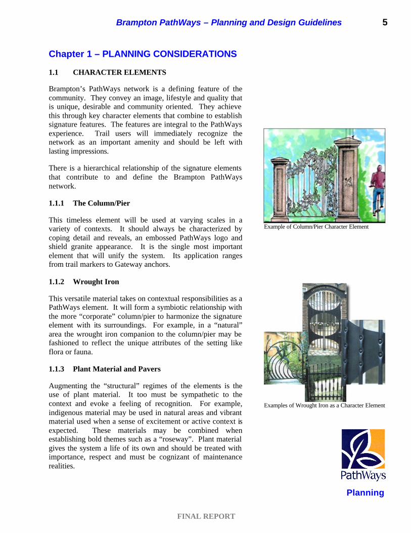
1.1.1 The Column/Pier
This timeless element will be used at varying scales in a variety of contexts. It should always be characterized by coping detail and reveals, an embossed PathWays logo and shield granite appearance. It is the single most important element that will unify the system. Its application ranges from trail markers to Gateway anchors.
1.1.2 Wrought Iron
This versatile material takes on contextual responsibilities as a PathWays element. It will form a symbiotic relationship with the more “corporate” column/pier to harmonize the signature element with its surroundings. For example, in a “natural” area the wrought iron companion to the column/pier may be fashioned to reflect the unique attributes of the setting like flora or fauna.
1.1.3 Plant Material and Pavers
Augmenting the “structural” regimes of the elements is the use of plant material. It too must be sympathetic to the context and evoke a feeling of recognition. For example, indigenous material may be used in natural areas and vibrant material used when a sense of excitement or active context is expected. These materials may be combined when establishing bold themes such as a “roseway”. Plant material gives the system a life of its own and should be treated with importance, respect and must be cognizant of maintenance realities.
Example of Column/Pier Character Element
Examples of Wrought Iron as a Character Element

6 Brampton PathWays – Planning and Design Guidelines
Planning
FINAL REPORT
Another important design and character element is the use of pavers. When designing treatments such as plaza spaces or rest areas a “Brussels Block” (textured, weathered) square sandstone paver is recommended. In addition to the block, a banding constructed of “Unigranite” (textured black) should be used as an accent.
1.1.4 Gateways
A principle feature of the PathWays system is the use of gateways. It is suggested that a hierarchy be established that represents a community, local and thematic level contexts.
Community Gateway
These features are intended to set the tone for the system. They introduce Brampton as a community oriented place and are intended to create a sense of welcome, arrival and safety. They are characterized by their plaza-like design and appeal to a variety of senses (sight, smell, touch and in some cases sound). They are also an opportunity to establish trail use conventions, punctuate historic significance and establish thematic backdrops. A bold use of columns and piers is required, companioned with rich wrought iron treatments and plaza space using “Brussels Block” (textured, weathered square sandstone pavers) and bands of “unigranite” (textured black pavers). They also boast generous/lush plant material that must always be sympathetic to the feature’s context. It is also important to offer people amenities such as benches, trash receptacles, drinking fountains and information/ directional kiosks.
Example of a Community Gateway

Planning
FINAL REPORT
Brampton PathWays – Planning and Design Guidelines 7
Local and Thematic Gateway
The local gateway maintains a more “pragmatic” tone. They primarily reaffirm PathWays conventions and introduce locally significant themes. They also prepare Brampton residents and visitors for transitions during the system experience. They are often paired with information and wayfinding signs. Similar to the Community Gateway, a Local Gateway maintains elements such as columns, piers and wrought iron and is augmented with the signature pavers. They punctuate the system at a reduced scale and less density. Unlike the Community Gateway they may not be associated with “plaza” space. They will become a recognizable feature in the Brampton landscape and are important to its customers. These sights should become an integral part of the marketing initiative and should be identified on the City map and identified through a geodetic system.
1.1.5 Points of Interest
Resting spots and points of interest (cultural or otherwise) reaffirm the PathWays system and the Community of Brampton as unique, desirable and people oriented. They are nodes where PathWays customers (trail users) seek refuge and captivate diverse experiences. They could also conceivably function as safety zones, in that some may provide emergency response equipment such as telephone, alert lights and panic buttons. They are also ideal for trail distance marking and interpretive opportunities. These “stations” are all about the customer.
Example of a Local Gateway

8 Brampton PathWays – Planning and Design Guidelines
Planning
FINAL REPORT
1.1.6 The Route – It (the PathWays) overrides Brampton’s conventional infrastructure and places pedestrians first!
One of the boldest statements that the PathWays will make is that customer needs are paramount. It is important to view it as a system and as such it must be seamless and consistent. For example, where the system intersects with or over-laps sidewalks, or is paired with another component of the transportation network, the trail should not take less priority.
1.1.7 Themes, Art and Attractions
Defining within districts, links and sections may present unique opportunities with respect to character. Often trail routes are identified by their character rather then name. It is conceivable that outdoor art may punctuate trail sections. This may well be in response to cultural identity, historical significance or simply in response to design intent. Another trait may be to promote bosks of plant material to reinforce a particular theme or message.
1.1.8 Bridges as Important Design Elements
Bridge cladding could be used as an important PathWays identifier. By the addition of a PathWays logo or embossed element within the forming, customers will identify these elements as integral part of the PathWays experience.
1.1.9 PathWays Signatures and Features
Table 1.1 summarizes some of the key character elements or “PathWays Signatures”.
Example of a Point of Interest
Dancing Bear – Windsor, Ontario
Example of bridge design treatment

Planning
FINAL REPORT
Brampton PathWays – Planning and Design Guidelines 9
Table 1.1
PathWays Signatures and Features
Treatment Description Application Elements
Coping detail
Embossed PathWays logo
Shield Granite Appearance
Column/pier This timeless element will be used at varying scales in a variety of contexts. It is the single most import element that will unify the system.
Ranges from trail marker to Gateway and/or transition anchor. It may also be used to punctuate import trail destination or area of historic, cultural or environmental significance
Size - +/- 720w2 x 2000h
Wrought Iron This versatile material takes on contextual responsibilities as a PathWays element to harmonize the signature element with its surroundings.
It will form an important relationship with the more “corporate” column/pier and may to reflect the unique attributes of the setting like flora or fauna or take on a variety of looks depending on the location and context.
Wrought Iron fashioned designs connected to column
Paving “Brussels Block” (textured, weathered square sandstone pavers) and bands of “unigranite” (textured black pavers).
Any hard surface treatment required for plaza space important connections, to punctuate points of interest and possibly for areas specifically designed for pedestrian travel or where caution and lower speeds are required.
Pavers with approved colour
Plant Material Augmenting the “structural” elements is the use of plant material and represents the most fluid element. It must reflect the context and functions as a softening element intended to evoke a feeling of recognition related to the context. Plant material gives the system a life of its own and should be treated with importance and respect.
Examples include the use of indigenous material in natural areas; vibrant material when a sense of excitement or active context is expected; massing when establishing bold themes such as a “roseway”. Consideration must always be given to maintenance realities and the safety of PathWays customers
Varies
Gateways!
Principle features of the PathWays system are the use of gateways. A hierarchy has been established that represents community, local and thematic level contexts.

10 Brampton PathWays – Planning and Design Guidelines
Planning
FINAL REPORT
PathWays Signatures and Features (cont'd)
Feature Description Application Elements
Community Gateway
A bold use of columns/pier are required companioned with rich wrought iron treatments and plaza space using “Brussels Block” (textured, weathered square sandstone pavers) and bands of “unigranite” (textured black pavers). They also boast generous/lush plant material that must always reflect the feature’s context/district. It is also important to offer people amenities such as benches, trash receptacles, drinking fountains and information/directional kiosks.
These features are intended to set the tone for the system itself. They introduce Brampton as a community oriented place and create a sense of welcome, arrival and safety. They are recognized by their plaza like design and appeal to a variety of senses (sight, smell, touch and in some cases sound). They are an opportunity to establish trail use conventions, punctuate historic significance and establish thematic backdrops and district characteristics. They are generally at locations where and adjacent system (Toronto, Mississauga, Halton Hills and Vaughan) meets Brampton or where a significant community amenity or space is to be introduced such as the Downtown.
q Column/pier
q Wrought Iron
q Pavers and Plant material
q Plaza space
q Furniture
q Information signage
q Lighting (ambient)
Local and/or Thematic Gateway
A Local/Thematic Gateway maintains elements such as column/pier and wrought iron and is augmented with the signature pavers. They punctuate the system at a reduced scale and are less densely planted. Unlike the Community Gateway they are not associated with “plaza” space. There are generally associated with “wayfinding” or directional signage.
The local gateway maintains a more “pragmatic” tone. They primarily reaffirm PathWays conventions and introduce locally significant themes, changes in districts or transitions into a point of interest such as a park or community/recreation centre. They also prepare Brampton customers for transitions during the system experience.
q Column/pier
q Wrought Iron
q Pavers and Plant material
q Information signage
q Clearly marked point number

Planning
FINAL REPORT
Brampton PathWays – Planning and Design Guidelines 11
PathWays Signatures and Features (cont’d)
Feature Description Application Elements
Point of Interest
These “stations” are all about the customer. They have a “Plaza” like design hosting benches, trash receptacles, lights and PathWays markers. Shade cover is also desirable for resting during the summer months.
Resting spots and points of interest (cultural or otherwise) reaffirm the PathWays system and the Community of Brampton as unique, desirable and people oriented. They are nodes where PathWays customers seek refuge and illustrate diverse experiences. They should be no more then a 10 minute walk similar to the criteria of PathWays access points.
q Plant material
q Information signage
q Clearly marked point number
q Plaza space
q Furniture
q Information signage
q Lighting (ambient)
The Route The PathWays overrides Brampton’s conventional infrastructure and places pedestrians first! One of the boldest statements the PathWays is intended to make is that customers needs are paramount. It is important to view it as a system and, as such, it must be seamless and consistent.
For illustration purposes, an example where the systems intersects or over-laps sidewalks or is paired with another transportation network, the PathWays will take priority.
q Asphalt
q Granular
q Lockstone
q Markings (where applicable)
q Non-encroachment zone (see relevant design section)
q Signage (see relevant design section)
q Lighting (see relevant design section)
q Character Element see relevant design section)

12 Brampton PathWays – Planning and Design Guidelines
Planning
FINAL REPORT
1.2 TRAIL CLASSIFICATIONS
The Brampton PathWays network was developed to provide both Community and Neighbourhood systems. Within each of these systems, trails are divided into three classes of facility types: multi-use paths, bike lanes and signed bicycle and trail routes. These classes range from fully separated trails to the designation of bike routes on streets. Design standards associated with each “class” of facility are subject to a number of factors including site conditions, location, potential level of use, and existing or appropriate materials.
In addition, there are trails and paths which currently exist in Brampton which are not part of the formal PathWays network. The following briefly outlines the trail classifications for the Brampton PathWays network:
1.2.1 Class 1 – Multi-Use Path
A Class 1 – Multi-Use Path is a facility that is completely separate from the travelled portion of a roadway, although it may take the form of a boulevard trail in a public road right-of-way or greenway. These types of trails are typically designed to encourage the widest range of users including pedestrians, cyclists, in-line skaters and skateboarders. While cyclists are permitted to use paths and trails, there are instances where their use may be discouraged for safety reasons or to minimize impacts to the natural environment. Multi-use trails located in parks typically serve primarily recreational cyclists, although there are notable exceptions. These can include trails along valleylands and river corridors, or adjacent to active or abandoned rail lines, hydro corridors and other linear routes that serve the needs of both recreational and utilitarian cyclists.
1.2.2 Class 2 – Bike Lane
A Class 2 – Bike Lane is a facility located in the travelled portion of the street or roadway and is designed for one-way cyclist traffic. In-line skaters may use this facility as well, or they may use the sidewalk along with pedestrians.
1.2.3 Class 3 – Signed Route
A Class 3 – Signed Route is an on-road bicycle route denoted with signage. Users share the pavement with motor vehicles, and there are no special lane designations. Again, in-line skaters may use this on-road facility, while pedestrians are expected to use the sidewalk.
Class 1 Example Brampton Multi-Use Path
Class 2 Example Bike Lane
Class 3 Example Signed Route

Planning
FINAL REPORT
Brampton PathWays – Planning and Design Guidelines 13
Other off-road bicycle facilities, including single-track bicycle paths typically favoured by mountain bike enthusiasts, are becoming increasingly popular. Typically they are not part of a formal trail system, and therefore are not addressed in this reference guide.
1.3 TYPES OF TRAIL USERS
A successful trail facility should provide an exclusive and comfortable environment for the anticipated users. It is therefore important to identify the target group for whom the facility is being designed. While there is a wide range of skill levels and considerable variation in typical trip length and purpose, from a planning perspective, trail users can generally be grouped according to age, skill level and activity/trip purpose.
1.3.1 Age
Adults constitute the main group of trail infrastructure users. Their skill levels vary based on their experience and age. Trips may range from casual recreational usage around the local neighbourhood (67%), to utilitarian travel over long distances each day for work, shopping or fitness purposes (32%).1
Children, especially those under the age of 13, often walk, in-line skate or ride their bikes on residential streets, trails and sidewalks to get to the corner store, school, friends’ homes and recreational areas. The Environics survey indicated that 30% of households reported trail use for fitness and recreation purposes by children, while 17% reported trail use for practical purposes.
Children’s motor skills and physical size are not always fully developed. This makes them less visible and prone to unpredictable manoeuvres, which may impact their ability to react to hazardous situations. Trail designers must consider children when selecting key design parameters. For this reason, where use by children is expected, young trail users must be made aware of the rules of the road and safe riding techniques. Schools, Police and parents should be encouraged to “educate” children in these areas. The City of Brampton can assist through the provision of educational and promotional material.
1 Brampton Trails, Report on Quantitative Research Results, Environics Research Group, 2001.

14 Brampton PathWays – Planning and Design Guidelines
Planning
FINAL REPORT
1.3.2 Skill Level
Casual users typically use the trail occasionally, often within their local neighbourhood or to access local community destinations. They usually avoid roads with moderate to high traffic volumes, and generally obey the rules of the road that are relevant and that they understand. They become easily discouraged by unfavourable trail conditions, and typically prefer residential streets, and off-road trails. Ideal off-road conditions are wide, flat routes, which do not require a high level of skill or a high degree of attention to bicycle handling and control. The public attitude survey undertaken as part of the master plan process indicates that most trips undertaken by Brampton trail users are less than 7 km, or half an hour, in length.
Experienced users use the trail network frequently and do so for both recreational and utilitarian purposes. They generally have good in-line skating and bike handling skills, and are not often discouraged by traffic or adverse trail conditions. In urban areas, utilitarian cyclists tend to prefer wide shared curb lanes and on-street bike lanes, or paved shoulders on low volume roads in rural areas. As for off-road conditions, they prefer a wide range of trail types, with some preferring challenging trails that offer a variety in topography and surface conditions.
1.3.3 Trip Purpose
Recreational trail users most often will use the network for fitness or leisure. The public attitude survey revealed that “fitness and recreation accounts for 67% of trail use among those 15 years of age or older. Walking is the primary modal choice among recreational users (81%), followed by cycling (37%), jogging (13%), in-line skating (11%) or pushing a stroller (9%)”2. In order to encourage increased recreational use of the PathWays system, residents suggested easy access to brochures and maps, greater interest and use among family and friends, public restrooms along the trails, access to free phones, educational programs, access to nearby venues and equipment rentals at primary staging points of the trail as potential improvements to the PathWays system. Safety was reported as residents’ greatest concern when walking, jogging, in-line skating or cycling in the City.
2 Brampton Trails, Report on Quantitative Research Results, Environics Research Group, 2001.
Recreational trail users – Bach Park

Planning
FINAL REPORT
Brampton PathWays – Planning and Design Guidelines 15
Other research has found that excessive distance and unsafe traffic conditions are often cited as major obstacles that discourage recreational users from becoming utilitarian users. This group also cites incompatibility with work clothes, lack of shower, change room and bicycle parking facilities, plus the difficulty in carrying personal belongings while cycling/in-line skating as barriers to using the trail network for utilitarian trips. As standards for work dress have become more casual in recent years, the incompatibility with work clothes has become less of an issue.
Utilitarian trail users often will use the network system year-round in all weather conditions, although seasonally they may switch to public transit or other modes. They are typically commuters and generally have good mobility skills and a commitment to use the trail network whenever possible.
The public attitude survey revealed that “practical” users account for 32% of trail use among those 15 years of age or older. Walking is the primary modal choice among practical users (85%), followed by cycling (32%), pushing a stroller (12%), in-line skating (9%) and jogging (6%).3 In order to encourage increased utilitarian use of the PathWays system, residents of Brampton suggested that the trails should be expanded to make the system more convenient or useful, more information should be provided about the trails, and maintenance and safety improvements should be undertaken.
1.4 ROUTE SELECTION CRITERIA
A strategic level assessment typically occurs at a city-wide or community level. This initial stage of the route selection process typically results in the selection of preferred trail corridors. In order to define the preferred corridors, five key considerations are recommended:
• Connections – Preferred corridors should be located to connect and extend existing trail segments. This will provide a seamless PathWays system across Brampton.
• Spacing – Preferred corridors should be located to maintain network spacing equivalent to a 10-15 minute walk to a trail connection. This will ensure all Brampton residents have convenient access to the PathWays system.
3 Brampton Trails, Report on Quantitative Research Results, Environics Research Group, 2001.

16 Brampton PathWays – Planning and Design Guidelines
Planning
FINAL REPORT
• Destinations – Preferred corridors should be located to link desired destinations, including parks, community centres, schools and commercial centres. This will permit residents to use the system to get where they want to go.
• Visibility – Preferred corridors should be located where they will be highly visible. This will ensure residents are aware of the system, and those trails enhance the character of Brampton.
• Barriers – Preferred corridros should be located where major barriers, such as the 400 series highways and rail corridors, can be overcome, and a seamless connection can be made.
These considerations were used to guide the development of the city-wide Brampton PathWays network.

FINAL REPORT
Brampton PathWays – Planning and Design Guidelines 17
Design Parameters
Chapter 2 – DESIGN PARAMETERS
2.1 GENERAL CONSIDERATION
Careful consideration should be given to the physical, aesthetic and environmental requirements for each trail type. The appropriate balance of these requirements will assist in developing a trail system that will provide trail users with a suitable level of comfort and safety in an appealing setting. Each of these elements is outlined in this section with appropriate guidelines for trail design.
2.1.1 Characteristics of a Class 1 Multi-Use Trail
Figure 2.1 illustrates the cross-section of a Class 1 multi-use trail and the basic physical components that make up the user space. The following characteristics are included:
Travel Width
The horizontal dimension across the trail travel surface which provides adequate space for comfort and safe movement.
Travel Surface
The hard-surfaced portion of the trail right-of-way typically sloped or crowned to provide proper drainage. Surface options include asphalt, concrete, granular, unit pavers and natural terrain depending on the trail’s intended use, setting and context.
Figure 2.1 – Cross-Section of a Class 1 Multi-Use Trail
FINAL REPORT
18 Brampton PathWays – Planning and Design Guidelines
Design Parameters
Clearing Width
The dimension measured across the trail from which all obstructions are removed so as not to obstruct movement along the trail. The clearing width includes a cleared area or fall zone beyond the travel surface.
Clearing Height
The vertical dimension which must be cleared of all tree branches, signs and other obstructions that would otherwise obstruct movement along the trail.
Drainage Provision of methods to manage excessive water runoff such as a ditch, swale, culvert, catch basic, etc.
2.1.2 Pedestrian, Cyclist and In-Line Skater Operating Space
An important factor in the development of safe and comfortable trail facilities is sufficient clearances between trail users and obstacles on the side of the trail, as well as with other trail users. These guidelines are significant because they must accommodate a wide range of skill levels among pedestrians, cyclists and in-line skaters. The following recommended criteria for trail alignments should be used whenever possible.
• The minimum recommended operating space allowance for two pedestrians to pass each other in the opposite direction on a sidewalk or trail, or for two pedestrians walking side by side in the same direction, is 1.2 m. The desirable space allowance is 1.5 m. The City of Brampton’s current standard for sidewalks in road rights-of-way is 1.5 m.
• Bicycles are distinct from all other modes of transport and are the lightest and smallest vehicles on the road and trail network. To assure safety and comfort, the design of trail facilities should account for the amount of space required by a moving cyclist.
The operating envelope for a cyclist consists of the actual space occupied by a bicycle and cyclist (typically 0.7 m wide by 2.0 m high). It includes an operating space allowance to accommodate the natural side to side movement of a cyclist plus variations in bicycle tracking (0.4 m each side plus 0.5 m above the cyclist). This translates to a minimum recommended one directional cycling lane width of 1.5 m for low speed, moderate

FINAL REPORT
Brampton PathWays – Planning and Design Guidelines 19
Design Parameters
traffic volume roadways. Because two cyclists passing each other in opposite directions benefit from a shared central 0.4 m manoeuvring allowance, the minimum recommended operating space allowance for two way traffic is 2.6 m.
• The minimum recommended operating space allowance for an in-line skater is 2.3 m. This is based on an average striding space, plus a manoeuvring allowance of 0.4 m on both sides. The manoeuvring space allows for the in-line skater to avoid hazards and provides room for the natural meandering of the activity.
Figure 2.2 illustrates the typical operating envelopes for bicycles and in-line skaters.
Figure 2.2 – Bicycle & In-Line Skate Operating Spaces Source: Design, Signage and Maintenance Guidelines, Waterfront Regeneration Trust, 1997.

FINAL REPORT
20 Brampton PathWays – Planning and Design Guidelines
Design Parameters
2.1.3 Clear Distance to Obstructions
Potential obstructions include guy wires, curbs, fences, utility poles, street furniture, signs and trees. The dimensions in Table 2.1 indicate the distance beyond the operating space that is required to pass by the obstruction. Every attempt should be made to provide this distance either by shifting the trail or, if possible, relocating the hazard. If this is not feasible, the obstruction should be made more visible or the potential danger reduced. This can be accomplished by adding warning signage, flagging, painting with a bright colour, eliminating projections or padding sharp edges. Trees and trailside foliage should be routinely maintained to ensure that the minimum clearance spaces are provided.
Table 2.1 – Clear Distance to Obstructions Beyond Operating Envelope
Minimum Preferred Vertical clearance to stationary objects
0.5 metres 1.0 metres
Horizontal clearance to stationary objects
1.0 metres 1.5 metres
2.1.4 Maximum Grades
There are two major considerations when designing grades: the effort to ascend or climb, and conditions required for safe descent.
For a cyclist riding on a bike without a transmission system, it is almost impossible to climb a 50 metre long 10% grade. Bicycles equipped with a simple transmission system allow almost every cyclist to climb a 50 metre 15% grade. However, grades greater than 5% should normally be avoided, and desirable conditions, especially for long uphill grades, should not exceed 3%. Where possible, on long steep grades it is desirable to introduce relatively flat rest areas approximately every 100 metres.

FINAL REPORT
Brampton PathWays – Planning and Design Guidelines 21
Design Parameters
Figure 2.3 illustrates the relationship between acceptable grade and grade length.
Where one-way bicycle operation is proposed and cyclists will be travelling in the downhill direction, steeper and/or longer grades are not as much of a concern. It should be recognized, however, that speeds and stopping distances increase when travelling downhill, and that the available sight distances must be checked accordingly.
The grades on which an in-line skater can safely operate depends upon the level of expertise of the individual. A beginner can comfortably traverse slopes of no more than 1% to 3%, while an expert may be able to manage slopes in excess of 10% for short distances. Grades on trails for which in-line skating is permitted should generally be less than 5%, except for very short sections. Table 2.2 identifies the grades for trails and roadways that can be generally handled by skaters based on skating “ability”.
Table 2.2 – Appropriate Grades for In-Line Skating
Gradient Maximum Distance Ability of Skater 1% - 3% 100 m Beginner/Novice 3% - 5% 100 m Beginner –
Intermediate 5% - 10% 100 m Experienced >10% Evaluation Required N/A
Source: In-Line Skating Review – Phase 2 – Final Report, TAC, 1997.
Figure 2.3 – Acceptable Grades for Design Purposes Source: Balshone, L. Bruce, Bicycle Transit: Its Planning and Design, Proeger, New York 1975

FINAL REPORT
22 Brampton PathWays – Planning and Design Guidelines
Design Parameters
2.1.5 Design Speed for Recreational Cyclists and In-Line Skaters
Most recreational cyclists can maintain a speed of 20 to 25 km/h, while utilitarian and fitness-oriented cyclists usually travel at higher speeds. In order to ensure that the trail system is safe for all users, a minimum design speed of 40 km/h should be provided. On descents with steeper grades (exceeding 4%), the design speed should be increased to 60 km/h.
It should be noted that since on-street bikeway systems utilize existing roadways which are generally constructed to a design speed of at least 50 km/h for motorized vehicles, sight distances and curvatures should, in most cases, exceed the minimum bikeway design parameters. In the majority of cases, the cyclist’s eye height is above that of the driver in a typical automobile, therefore the cyclist will actually be able to observe hazards at a greater distance.
2.1.6 Stopping Distances for Recreational Cyclists and In-Line Skaters
Minimum stopping sight distance for cyclists is the distance required to bring a bicycle to a full controlled stop upon spotting an obstacle. It is a function of the cyclists’ perception and reaction time prior to braking, the initial speed of the bicycle, the coefficient of friction between the tires and the bikeway surface, and the braking capacity of the bicycle.
The stopping sight distance is given by the formula:
S = 0.694V + V2 / 255 (f + G/100)
Where: S = stopping sight distance, m V = speed, km/h f = coefficient of friction G = grade, % (upgrade positive, downgrade negative)
Table 2.3 illustrates minimum stopping sight distances for a range of speeds and grades. It is based on 2.5 seconds of perception-reaction time and a coefficient of friction (f) of 0.25 that accounts for paved surfaces during wet weather and typical braking characteristics of bicycles.1 The coefficient of friction for unpaved surfaces should be reduced to 50% of those for paved surfaces.
1 AASHTO, Guide for the Development of Bicycle Facilities, 1999

FINAL REPORT
Brampton PathWays – Planning and Design Guidelines 23
Design Parameters
No definitive data is currently available regarding braking distances for in-line skaters, although it has been observed and confirmed by representatives of the manufacturers and anecdotal evidence from users, that a “skilled” in-line skater travelling at a similar speed to a bicycle, can stop in the same or shorter distance.2 It is, however, not appropriate to design for a skilled user. Novice in-line skaters tend to require more distance to stop than novice cyclists.
2.2 ALIGNMENT ELEMENTS
The alignment elements discussed in this section are based upon the requirements for cyclists. In general, these would also be sufficient for in-line skaters. Trails intended for primarily pedestrian use may have lower minimum standards, especially with regard to horizontal curves.
2.2.1 Horizontal Alignment
The minimum radius of a curve depends on the bicycle speed, super-elevation and coefficient of friction between the bicycle tires and the bikeway surface. The following formula should be used to determine the minimum radius of horizontal curves:
2 In-Line Skating Review – Phase 2 – Final Report, Transportation Association of Canada (TAC), December, 1997.
Table 2.3 – Minimum Stopping Sight Distances For Bicycles
Design speed (km/h) Grade
(%) 10 15 20 25 30 35 40 45 50
Minimum Stopping Sight Distance (m) +12 8 13 18 - - - - - - +10 8 13 18 24 - - - - - +8 8 13 19 25 32 - - - - +6 8 13 19 25 32 40 - - - +4 8 13 19 26 33 41 49 - - +2 8 14 20 26 34 42 51 61 - 0 9 14 20 27 35 44 53 63 74 -2 9 14 21 28 36 45 55 66 77 -4 9 15 21 29 38 47 58 69 81 -6 9 15 22 30 39 50 61 73 86 -8 9 16 23 32 42 53 65 68 92
-10 10 16 24 34 44 56 70 84 100 -12 10 17 26 36 48 61 76 92 110
Note: a positive grade is uphill, and a negative grade is downhill
Source: Geometric Design Guide for Canadian Roads, TAC, 1999.

FINAL REPORT
24 Brampton PathWays – Planning and Design Guidelines
Design Parameters
R=V2 / (127 x (e + f))
Where: R = radius, m V = speed, km/h e = super-elevation, m/m f = coefficient of lateral friction
For most applications and conditions, the coefficient of lateral friction varies from 0.3 at 25 km/h to 0.22 at 50 km/h, and for unpaved surfaces is reduced to 50% of those of paved surfaces. Table 2.4 provides the coefficient of lateral friction and minimum radius for a range of design speeds and super-elevation rates.
Horizontal curves must be of sufficiently large radius to ensure that cyclists can safely negotiate the curve at the design speed. When horizontal curves are of very small radius, bikeway widening should be considered to compensate for the tendency of cyclists to track toward the inside of the curve. Widenings are not necessary for curves over a 32 m radius, and will therefore not usually be a consideration for on-street routes. Table 2.5 shows the recommended widening of the riding surface on curves.
Table 2.5 – Widening Of The Riding Surface On Curves
Radius of Extra width required Curvature (m) (grade = 0 to 3%)
24 to 32 250 mm 16 to 24 500 mm 8 to 16 750 mm 0 to 8 1,000 mm
Source: Technical Handbook of Bikeway Design, Velo Quebec, 1992.
Horizontal curves must also be checked to ensure that there are no obstructions located on the inside of the curve, which could block the cyclists’ line of sight and reduce available stopping sight distance. Vegetation should be cut back such that it does not obscure the line of sight around a curve.
Table 2.4 – Minimum Radii for Paved Trails
Design speed Coefficient of Minimum radius, m km/h lateral friction e=0.02 m/m e=0.05 m/m
25 0.30 15 14 30 0.28 24 21 35 0.27 33 30 40 0.25 47 42 45 0.23 64 57 50 0.22 82 73
Source: Geometric Design Guide for Canadian Roads, TAC, 1999.

FINAL REPORT
Brampton PathWays – Planning and Design Guidelines 25
Design Parameters
2.2.2 Vertical Alignment
The minimum length of crest vertical curves depends on the minimum stopping sight distance for the design speed of the facility. This is calculated to satisfy the safety requirements of bringing a bicycle from full speed to a full stop when an obstacle is spotted on the bikeway surface. Table 2.6 shows vertical curve lengths for different design conditions for paved surfaces under wet conditions. Stopping sight distance for unpaved surfaces should be adjusted accordingly to satisfy reduced lateral friction conditions equal to 50% of those for paved surfaces.
Above the line, stopping sight distances are greater than the curve length, and L=2S-274/A, where S = minimum stopping sight distance from Table 2.3, A = algebraic difference in grades in %. Below the line, stopping sight distances are less than the curve length and L=AS2/274.
The criterion for bicycles on sag curves is comfort, which is expressed in terms of a vertical maximum radial acceleration of 0.3 m/s2. However, it is important to consider non-illuminated bicycle paths, which might be used by cyclists after dark, by providing them with longer vertical curves. Table 2.7 provides K values corresponding to different design speeds based on the equation K=V2/390, where V = speed in km/h.
It is recommended that steep grades be widened to allow cyclists the extra space needed to either make corrections to their trajectory at higher speeds going downhill, or to
Table 2.6 – Crest Vertical Curve Lengths
Minimum curve length, m Change of Design speed, km/h
grade % 10 15 20 25 30 35 40 45 50 2 - - - - - - - - 11 5 - - - - 15 32 51 71 100
10 - - 13 27 44 69 102 145 199 15 - 10 22 40 67 104 153 - - 20 3 14 30 54 - - - - - 25 6 18 37 - - - - - -
Source: Geometric Design Guide for Canadian Roads, TAC, 1999.
Table 2.7 – Sag Vertical Curves For Bicycles
Design speed, km/h 25 30 35 40 45 50 Minimum sag curvature (k), m 1.5 2.5 3 4 5 6
Source: Geometric Design Guide for Canadian Roads, TAC, 1999.
FINAL REPORT
26 Brampton PathWays – Planning and Design Guidelines
Design Parameters
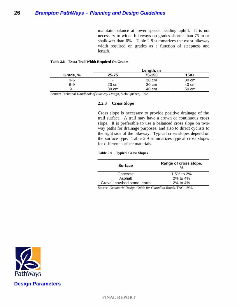
maintain balance at lower speeds heading uphill. It is not necessary to widen bikeways on grades shorter than 75 m or shallower than 6%. Table 2.8 summarizes the extra bikeway width required on grades as a function of steepness and length.
2.2.3 Cross Slope
Cross slope is necessary to provide positive drainage of the trail surface. A trail may have a crown or continuous cross slope. It is preferable to use a balanced cross slope on two-way paths for drainage purposes, and also to direct cyclists to the right side of the bikeway. Typical cross slopes depend on the surface type. Table 2.9 summarizes typical cross slopes for different surface materials.
Table 2.9 – Typical Cross Slopes
Surface Range of cross slope, %
Concrete 1.5% to 2% Asphalt 2% to 4%
Gravel, crushed stone, earth 2% to 4% Source: Geometric Design Guide for Canadian Roads, TAC, 1999.
Table 2.8 – Extra Trail Width Required On Grades
Length, m Grade, % 25-75 75-150 150+
3-6 - 20 cm 30 cm 6-9 20 cm 30 cm 40 cm 9+ 30 cm 40 cm 50 cm
Source: Technical Handbook of Bikeway Design, Velo Quebec, 1992.

FINAL REPORT
Design SpecificationsClass 1 – Multi-Use Path
Brampton PathWays – Planning and Design Guidelines 27
Chapter 3 – DESIGN SPECIFICATIONS
3.1 CLASS 1 – MULTI-USE PATH
Off-road multi-use trails are the backbone of the Brampton PathWays Network. They are typically incorporated into parkland and valleyland, or within the boulevards of road rights-of-way. Design criteria for these facilities are described below.
3.1.1 Existing Brampton Standards, Guidelines & Principles
The existing City of Brampton standard indicates that multi-use recreational trails are typically incorporated into parkland/valleylands or within the boulevards of road rights-of-way.
The design of the parkland/valleyland trail system is typically a 2.4 metre wide asphalt path allowing for two way recreational cycling.
The typical road right-of-way trail incorporates either a 2.4 metre two-way directional path or a 1.5 metre wide one-way directional path within the boulevard between the curb and the property line. The 2.4 metre wide path is located adjacent to the sidewalk or is installed in lieu of a sidewalk. On smaller roads, the 1.5 metre wide path occurs on each side of the road and is constructed adjacent to a 1.0 metre wide asphalt killstrip.1
Multi-use trails within the road right-of-way are currently limited to Parkway road standards and some sections of Bovaird Drive.
3.1.2 Review of Current Industry Guidelines and Policies
Multi use trails should be designed to accommodate a variety of user groups. A review of various bikeway and trail design guidelines from throughout North America indicates that standards vary depending upon the trail’s location, the anticipated number of users and the permitted uses. The minimum width is typically 3.0 m, which allows for bi-directional flow. On popular, heavily travelled multi-use
1 City of Brampton, Landscape Development Guidelines, April 2000.
Chinguacousy Trail – Brampton, Ontario

FINAL REPORT
Design Specifications Class 1 – Multi-Use Path
28 Brampton PathWays – Planning and Design Guidelines
trails, widths of up to 3.5 m are recommended to allow for a wider variety and greater number of users.
3.1.3 Trail Surface Types
Recommended multi-use trail surfaces include stonedust or asphalt. Recently, some municipalities have been experimenting with concrete and also asphalt mixes that use materials such as recycled asphalt, plastics, rubber and ground glass. Certain types of granular surfaces limit trail access for other wheeled uses such as in-line skaters, strollers and wheelchairs, so intended uses should be considered prior to the specification of surface materials. In high volume or tourist areas, it may be desirable to separate slower users from faster ones by providing separated trails.
Compacted stonedust is a common surface treatment for multi-use paths with fewer than 500 users per weekend day. This surfacing is less expensive than other alternatives, but requires periodic maintenance. Asphalt is widely used for trails with more than 500 users per weekend day. Poured-in-place concrete may be appropriate for trail use, but is a much more expensive alternative. In addition, concrete expansion joints can create a bumpy surface due to differential settling of the slabs over time. Concrete pavers and bare earth are not recommended for cyclists or in-line skaters, and are difficult for disabled users. Bare earth becomes rutted when wet. Wood chips are unacceptable for multi-use trails because they can cause flat tires. Asphalt is recommended for in-line skaters and trail users with disabilities. Boardwalks and metal bridges are not recommended for in-line skaters.
A new product has been introduced for use on steep sections of stonedust trails. It is a stabilizer that binds the stone chips and reduces erosion of the path. A synthetic or plant compound is incorporated within the limestone screenings and set with water. The additional cost of the stabilizer increases the cost of a stonedust trail to an amount similar to that of an asphalt surface. In some cases, stabilized stonedust may be preferable to asphalt because it is repairable and also is easier to install in confined or remote areas.
3.1.4 Recommended City of Brampton Standard
The recommended guideline for the City of Brampton Class 1 Boulevard Multi-Use Trail is summarized in Table 3.1. A schematic illustration is provided in Figure 3.1.
Professor’s Lake Trail – Brampton, Ontario

FINAL REPORT
Design SpecificationsClass 1 – Multi-Use Path
Brampton PathWays – Planning and Design Guidelines 29
Table 3.1 – Recommended Guideline: Boulevard Multi-Use Trail
Class 1 – Boulevard Multi-Use Trail
Travel Width 3.0 m preferred
Travel Surface Asphalt preferred
Clearing Width 6.0 m preferred
Clearing Height 3.0 m preferred
Desirable Grades < 3%
Other potential configurations for implementing a boulevard multi-use trail within an unconstrained right-of-way may include:
• Boulevard trails on both sides of the road right-of-way. These could be implemented where Class 1 trails are used to connect Class 2 or Class 3 bike facilities where cyclists normally use both sides of the roadway.
• Boulevard trails on both sides of the road right-of-way combined with parallel sidewalks on one or both sides of the street.
The recommended guideline for the City of Brampton Class 1 Off-Road Multi-Use Path is summarized in Table 3.2. A schematic illustration is provided in Figure 3.2.
Figure 3.1 – Boulevard Multi-Use Trail, Typical Cross Section

FINAL REPORT
Design Specifications Class 1 – Multi-Use Path
30 Brampton PathWays – Planning and Design Guidelines
Table 3.2 – Recommended Guideline: Off-Road Multi-Use Path
Class 1 – Off-Road Multi-Use Path
Travel Width 3.0 m preferred 3.5 m in areas of high trail use
Travel Surface Asphalt preferred
Clearing Width 6.0 m preferred
Clearing Height 3.0 m preferred
Desirable Grades < 3%
3.1.5 Implementation and Trade-Offs
For new roadways, it is recommended that the guideline be followed for the highest form of continuity across the network. For road reconstruction, it may not be feasible to follow the guideline exactly, and some leeway is available. This section outlines some of the implementation and trade-off options for Class 1 Multi-Use Paths.
The proposed guideline for a Boulevard Multi-Use Trail includes a single bi-directional asphalt trail on one side of the road right-of-way, with no provision for sidewalks on either side. The option of designing a parallel sidewalk should be based on the expected pedestrian demand and adjacent land uses. If an exclusive pedestrian facility is not provided, extra width along the multi-use boulevard trail should be provided to accommodate the additional pedestrian traffic. The construction and maintenance costs of a single system versus
Figure 3.2 – Off-Road Multi-Use Path, Typical Cross Section

Brampton PathWays – Planning and Design Guidelines 31
Design SpecificationsClass 2 – Bike Lanes
FINAL REPORT
parallel facilities are considerably lower, and would lead to a more unified feel of the trail system.
In areas where right-of-way is limited and anticipated demand is low, a minimum trail width of 2.4 m can be assumed. In this case, however, consideration should be given to the future widening of the trail to the design standard of 3.0 m to better accommodate all users.
3.2 CLASS 2 – BIKE LANES
Where off-road routes are not feasible or desirable, bike lanes should be considered to establish key connections between adjacent systems and to facilitate utilitarian use. The on-road facility design criteria is based on the class of roadway on which the facility will be constructed, as well as anticipated demand and right-of-way availability.
For routes which are served by bike lanes, it is expected that pedestrians and in-line skaters will be accommodated on the sidewalk. However, it must be recognized that in-line skaters may prefer to use the bike lane.
3.2.1 Existing Brampton Standards, Guidelines & Principles
The current City of Brampton standard for on-street bike lanes is as follows:
A bicycle lane is a specific lane for bicycles on the roadway. This type of lane is identified by a separation line from the vehicular travelled portion of the road and shall have signage and/or bicycle symbols painted on the road surface. The bicycle lane could, in areas, be combined with bus transit traffic due to space limitations such as the proposed Queen Street corridor route from Centre Street east to Highway No. 50.2
This standard currently only applies to the Queen Street corridor, and has not yet been implemented.
3.2.2 Review of Current Industry Guidelines and Policies
Bike lanes have several advantages over wide shared lanes. Some of these include exclusive space, a higher level of safety
2 City of Brampton, Landscape Development Guidelines, April 2000.
Bike Lane on St. George Street, Toronto, Ontario

FINAL REPORT
Design Specifications Class 2 – Bike Lanes
32 Brampton PathWays – Planning and Design Guidelines
and an increased compliance with traffic control devices. In a study comparing streets with bike lanes and those without, it was observed that on streets with bike lanes, 81% of cyclists obeyed stop signs, compared to only 55% on streets without.3
Bike lanes are therefore attractive to less skilled cyclists and may encourage more people to cycle. The optimum recommended bike lane width is 1.5 m (1.2 m minimum to 1.8 m maximum), enabling cyclists to travel in single file. Lane widths greater than 1.8 m are not recommended since they may encourage use by motor vehicle drivers for passing other vehicles on the right, or for stopping and parking.
3.2.3 Recommended City of Brampton Standard
The recommended width of an on-road bike lane in the City of Brampton is summarized in Table 3.3. A schematic illustration is provided in Figure 3.3. This type of lane should be separated from the vehicular travelled portion of the road using pavement markings, and should be clearly identified through signage and symbolic pavement markings.
Table 3.3 – Recommended Guideline: On-Road Bicycle Lane
On-Road Bicycle Lane
Travel Width 1.5 m preferred
3.2.4 Bike Lanes with On-Street Parking
Bike lanes on roads with on-street parking are located to the left of and adjacent to parked vehicles along the curb. Designing this type of bikeway facility must take into consideration the potential hazard to cyclists of car doors opening into the travelled portion of the bikeway. In order to allow clearance for vehicle doors, and to minimize collisions with cyclists, the combined bicycle/parking lane should be a minimum of 4.0 m wide. This width allows for a 1.8 m bike lane and a 2.2 m wide curbside parking stall. The extra distance added to the typical 2.0 m wide parking stall provides space for the opening of car doors, and encourages cyclists to travel a safe distance from the parked vehicles. As an alternative, the width of the bike lane may be reduced if the parking aisle is greater than 2.4 m wide.
3 Bicycle Lanes versus Wide Curb Lanes: Operational and Safety Findings, Federal Highway Administration, May 1998.

Brampton PathWays – Planning and Design Guidelines 33
Design SpecificationsClass 2 – Bike Lanes
FINAL REPORT
Bike lanes on roads with on-street parking should be considered in commercial and residential areas where the demand for and turnover of parking is high, and where commercial and residential property owners may not accept the reduction or prohibition of on-street parking.
The recommended guideline for City of Brampton Bike Lanes with On-Street Parking is summarized in Table 3.4. A schematic illustration is provided in Figure 3.4.
Table 3.4 – Recommended Guideline: Bicycle Lane with On-Street Parking
Bicycle Lane with On-Street Parking
Travel Width 1.8 m Bike Lane + 2.2 m Parking Stall
3.2.5 Implementation and Trade-Offs
Where it is not feasible to install dedicated bike lanes, the applicability of a signed route or a multi-use boulevard trail should be evaluated. Other route alignments may also need to be considered.
Figure 3.3 – Typical Bike Lane Cross Section

34 Brampton PathWays – Planning and Design Guidelines
FINAL REPORT
Design Specifications Class 3 – Signed Route
3.3 CLASS 3 – SIGNED ROUTES
3.3.1 Existing Brampton Standards, Guidelines & Principles
There is currently no Brampton standard for the design of on-street signed routes.
3.3.2 Review of Current Industry Guidelines and Policies
On-street signed routes are typically implemented on local and collector roads to form a connection or link in a trail network. On-street signed routes should only be implemented where wide curb lanes exist or can be provided, or where traffic volumes are low, such as is typically found on a local or collector road. An on-street signed route can also form part of a trail network when the addition of bike lanes is not possible in the short term due to limited pavement or right-of-way widths and/or because of on-street parking.
In addition to trail route marker signs for on-street signed routes, consideration should be given to shared-use pavement markings and/or “share the road” signs.
3.3.3 Recommended City of Brampton Standard
The recommended guideline for City of Brampton On-Street Signed Routes is summarized in Table 3.5. A schematic illustration is provided in Figure 3.5.
Figure 3.4 – Bike Lane with On-Street Parking Cross Section

Brampton PathWays – Planning and Design Guidelines 35
Design SpecificationsClass 3 – Signed Route
FINAL REPORT
Table 3.5 – Recommended Guideline: On-Street Signed Route
On-Street Signed Route
Travel Width
4.0 m – 4.5 m wide curb lane recommended
3.3.4 Implementation and Trade-Offs
Streets should typically only be signed as on-road bike routes if there is adequate pavement width to safely accommodate both motor vehicles and cyclists. Otherwise, alternative routes should be investigated. In some locations, narrow roadways may be appropriate or preferred if traffic volumes are very low and little to no truck traffic exists.
Figure 3.5 – On-Street Signed Route, Typical Cross Section

FINAL REPORT
Design Specifications Bicycle Friendly Streets
36 Brampton PathWays – Planning and Design Guidelines
3.4 BICYCLE FRIENDLY STREETS
In terms of public policy, it is important to recognize that the bicycle is formally recognized as a vehicle by the Province of Ontario, as outlined in the Highway Traffic Act, R.S.O., 1990. Bicycles, therefore, have the right to share all classes of roadways, including arterials, collectors and local streets, with the exception of controlled access and 400 series highways.
The fact that bicycles have a right to use municipal, regional and provincial roadways leads to an important principle of roadway design, that “every road is a cycling road”. Municipalities, therefore, should adopt bicycle friendly design guidelines for all streets, whether a road is designated as part of a bikeway network or not. Bicycle friendly roadway features typically include, among other things, wide curb lanes plus drainage grates that are bicycle friendly and ideally located out of the desired path for cycling. Other features include traffic control devices that are programmed with bicycles in mind, particularly detector loops that have their sensitivity adjusted to allow bicycles to actuate a traffic signal.
It is imperative that the City of Brampton recognize that providing a multi-use trail system to serve a community does not release it from an obligation to ensure that all roadways in a community are designed, updated and maintained in a way that provides a safe environment for pedestrian and bicycle use. No matter how extensive the on or off-road trail facilities, some cyclists, especially commuters, will choose to ride on the road with traffic. They have that right and, accordingly, should feel safe and comfortable in doing so.
3.4.1 Wide Curb Lanes
Wide curb lanes should have sufficient width to allow motorists to pass cyclists without encroaching on an adjacent travel lane. Wide curb lanes should be encouraged for all road classifications to provide bicycle friendly streets, whether there is a designated bikeway or not. The preferred width for a wide curb lane is 4.5 m, with an acceptable range from 4.0 m to 5.0 m.
3.4.2 Paved Shoulders
A relatively easy way to provide for cyclists on roads with granular shoulders is to pave a 1.5 m wide section of the shoulder. Paved shoulders can be considered for on-road routes along rural sections with no curb or gutter edge and a speed limit at or below 80 km/h. Paved shoulders offer other advantages: they reduce maintenance costs associated with grading of gravel shoulders,

FINAL REPORT
Design SpecificationsBicycle Friendly Streets
Brampton PathWays – Planning and Design Guidelines 37
extend the life of the vehicle lanes, and reduce run-off-the-road collisions. However, it should be noted that paved shoulders are not ideal for year round cycling since they often are used, whether intentionally or not, for snow storage during winter months. A schematic illustration is provided in Figure 3.6.
3.5 SUMMARY OF DESIGN STANDARDS
Table 3.6 provides a summary of recommended design standards described in this chapter.
Figure 3.6 – Paved Shoulder: Rural Section
Table 3.6 – Summary of Design Standards
Trail Type Existing Brampton Standard
Proposed Brampton Standard
TRAVEL WIDTH
Class 1 – Multi-Use Path 2.4 m 3.0 m
Class 2 – Bike Lane • No On-Street Parking • On-Street Parking
1.5 m N/A
1.5 m
1.8 m + 2.2 m parking aisle
Class 3 – Signed Route
N/A
4.0 m – 4.5 m wide curb lane

FINAL REPORT
Design Specifications Bicycle Friendly Streets
38 Brampton PathWays – Planning and Design Guidelines
An example of alternative road cross sections incorporating the above guidelines is included in Appendix A for information purposes. It is recommended that the City of Brampton develop a set of alternative road cross sections to account for on-road bike lanes or boulevard multi-use trails. These should be developed as soon as possible so they can serve as input to roadway construction projects where PathWays facilities have been shown within the road right-of-way.

FINAL REPORT
Facility Selection
Brampton PathWays – Planning and Design Guidelines 39
Chapter 4 – FACILITY SELECTION
4.1 FACILITY TYPE CRITERIA
The different classes of trail facilities do not necessarily have a hierarchy in terms of safety or quality. Each of the facility types is appropriate under different sets of circumstances and conditions.
The selection process should be governed by two principles: facilities should not create operational problems, and should not encourage trail or motor vehicle use in a manner contrary to the normal rules of the road or trail etiquette. Adherence to these principles enhances both user safety and convenience. Another important consideration in selecting the type of facility is consistency. For example, alternating segments of boulevard trails and bike lanes along a route is generally not desirable, though sometimes this is necessary to achieve a continuous connection.
Selecting a preferred corridor to confirm the PathWays route and facility type typically involves seven key considerations:
• Access – Defined PathWays routes should provide direct and convenient access to destinations. This will serve the needs of Brampton’s residents.
• Intersections – Defined PathWays routes should intersect with other trails at key nodes, and overcome barriers such as expressways and rail lines. This will allow for efficient and safe movement along the PathWays system.
• Volume – Defined PathWays routes and facility types should be appropriate for the volume of traffic expected on and/or adjacent to the facility. This will ensure the route and facility is integrated with Brampton’s transportation system.
• User – Defined PathWays routes and facility types should accommodate expected users of the system, including pedestrians, cyclists and in-line skaters. This will allow the route and facility to meet the needs of Brampton residents.
• Continuity – Defined PathWays routes and facility types should provide continuity between existing and planned trails. This will provide for safe and extended use of the system by various skill levels and modes.

FINAL REPORT
Facility Selection
40 Brampton PathWays – Planning and Design Guidelines
• Gateways – Defined PathWays routes should have prominent city and neighbourhood entry points. This will provide trails that are defining features of Brampton.
• Views and vistas – Defined PathWays routes should provide views and vistas of prominent landmarks, community and neighbourhood features and open spaces. This will permit residents a diverse experience and provide the opportunity for the users to enjoy the PathWays system as a desirable amenity.
4.2 DETERMINING PREFERRED FACILITY TYPE
For any given route along a road right-of-way, consideration should be given to roadway operational characteristics in the route selection process. This includes consideration of such factors as traffic volumes, truck percentages, posted speed limits, existing pavement width, right-of-way width, on-street parking, collision history and other related elements.
Table 4.1 sets out guidelines that identify recommended trail facility types based on some of these operational characteristics.
Table 4.1 – Facility Selection Matrix
q LOCAL ROAD
- total AADT < 2,000 vpd
- ROW = 20.0 m
- pavement width = 8.0 m
- design speed = 50 km/h
q MINOR COLLECTOR ROAD
- total AADT: 2,000 - 6,000 vpd
- ROW = 23.0 m
- pavement width = 10.0 m
- design speed = 60 km/h
q MAJOR COLLECTOR ROAD
- total AADT: 6,000 - 20,000 vpd
- ROW = 26.0 m
- pavement width = 14.0 m
- design speed = 70 km/h
q ARTERIAL ROAD
- total AADT: > 6,000 vpd
- ROW = 36.0 m
- pavement width = 15.0 m
- design speed = 90 km/h
q INDUSTRIAL ROAD
- total AADT: varies
- ROW = 23.0 m
- pavement width = 10.0 m
- design speed = 60 km/h
typically, a minor collector road should support on-
road cyclists within the standard road width. Pedestrains would use the sidewalk. If there is a
high % of trucks, consideration should be given to provision of a wide curb lane or exclusive bike lane
consideration should be given to provision of an
exclusive bike lane
consideration should be given to provision of a wide curb lane or exclusive bike lane to increase the
separation between trucks and cyclists
consideration should be given to provision of an exclusive bike lane or a multi-use boulevard trail
typically, a local road should support on-road cyclists within the standard road width

FINAL REPORT
Facility Selection
Brampton PathWays – Planning and Design Guidelines 41
Other factors that should be considered in implementing on-road trails include:
• Traffic Volumes – If the roadway AADT is below the threshold for the existing lane configuration, it may be possible to reduce the number of lanes by one to provide for bike lanes, while maintaining the capacity for motor vehicles. The following are accepted thresholds for various roadways:
2 Lanes < 15,000 vpd 4 Lanes 15,000 – 30,000 vpd 6 Lanes > 30,000 vpd
• Posted Speed – If the posted speed is below the threshold for the existing lane widths, it may be possible to reduce the lane widths to provide bike lanes or wide curb lanes. The following are accepted thresholds for various posted speeds:
� 40 km/h 3.0 – 3.2 m 50 – 60 km/h 3.25 – 3.5 m (3.6 m TWLT lane) � 70 km/h 3.6 m (4.2 m TWLT lane)
• Truck Percentage – If there is a significant truck percentage along a proposed route, consideration should be given to an exclusive bike lane. This provides additional clearance area between cyclists and motor vehicle traffic. The following are accepted thresholds for truck percentages:
0% - 6% No additional consideration required
6% - 12% Consideration should be given to an exclusive bike lane
> 12% An exclusive bike lane should be provided to protect cyclists, or an alternative route identified
• Intersecting Roadways/Driveways – If there are a significant number of intersecting roadways or driveway crossings along the route, on-street bike lanes may be a preferred facility type. The following are accepted thresholds for driveway crossings:
0-3 crossings per km
A boulevard trail can be considered
4-5 crossings per km
Consider substituting with on-street bike lanes
> 5 crossings per km
Substitute with on-street bike lanes

FINAL REPORT
Facility Selection
42 Brampton PathWays – Planning and Design Guidelines

FINAL REPORT
Trail Amenities
Brampton PathWays – Planning and Design Guidelines 43
Chapter 5 – TRAIL AMENITIES
The provision of trail amenities is a key, and sometimes overlooked element of trail system design. Developing and maintaining a comprehensive network of on and off road trail facilities does not automatically mean people will use the network. The network has to be promoted, users need to feel comfortable and safe in using it, and they should have access to adequate parking and end-of-trip facilities at strategic locations. This section outlines many of the trail amenities which should be considered during the design of the trail network.
5.1 BICYCLE PARKING FACILITIES
Cyclists seek parking in locations that are frequented by pedestrians, visible from neighbouring buildings or that offer some other form of security from theft and vandalism. Bicycle theft is clearly a major problem in cities, and even with significant improvements in bicycle security devices over the last 10 years, bike theft remains a major deterrent to many that might otherwise cycle. There is no simple solution to the problem, but one can minimize the opportunity for theft by locating parking facilities in publicly visible and secure locations. Improving the supply and security of parking facilities for cyclists will have a significant impact on the attractiveness of cycling as a transportation mode. In addition, bicycle parking facilities are much more efficient in their use of space than automobile parking lots. Cars require 17 to 30 m2 per vehicle, whereas bicycles require only 1.0 to 1.7 m2 per unit.
Generally, optimum bicycle parking devices/facilities should:
• Enable the bicycle to be securely locked to the device without damaging the bicycle;
• Be placed in public view, where they can be viewed by passers-by, station attendants, fellow workers, etc;
• Present no hazard to pedestrians;
• Be easily accessible from the road or bikeway;
• Be arranged so that parking and unparking manoeuvres will not damage adjacent bicycles;
• Be as close as possible to the cyclist’s destination;
• Have appropriate security lighting, where possible;
• Shelter bikes from inclement weather, where possible;

FINAL REPORT
Trail Amenities
44 Brampton PathWays – Planning and Design Guidelines
• Be located in areas that are optimal for deterring theft and vandalism; and
• Easy to use without detailed instructions.
5.1.1 Bicycle Parking Facility Types
Bicycle parking systems can generally be grouped into three categories:
• Class 1: High Security;
• Class 2: Medium-High Security; and
• Class 3: Medium Security.
Class 1 – High Security. These facilities may be a protected parking area with a surveillance system or a key-access bicycle locker. They are recommended for long-term parking (work, school, transit stations, etc) and in low-visibility locations where there is little pedestrian traffic.
Class 2 – Medium-High Security. This type of system permits the bicycle frame and both wheels to be locked together without requiring the cyclist to remove one of the wheels from the bicycle frame. Although it does not protect all parts of the bicycle, it does protect the essential and most expensive components from theft. This type of facility is appropriate for office buildings, stores, educational institutions and public buildings.
Class 3 – Medium Security. These types of racks permit the frame and one wheel to be secured with a lock. Bicycle parking devices of this type are typically low in cost and tend to require less space per unit. They are suitable for short-term parking in busy locations.
In order to provide parking facilities, many municipalities are enacting legislation through by-laws to require new developments to furnish a minimum number of bicycle parking spaces. In many cases, municipalities offer bonusing provisions or other incentives to encourage developers to provide secure bicycle parking facilities plus change and shower rooms for a building’s employees. Many municipalities have developed bicycle parking programs where the City installs parking facilities along sidewalks in key retail areas, public buildings, and other key attractions and destinations. Some municipalities fund their bike parking program out of the municipal tax base, like the Cities of Toronto and Windsor. Others, like the City of Burlington
Bikestation – Long Beach, California
Medium-High Security Bicycle Parking Device
Medium Security Bike Parking – Bramalea GO Station, Brampton, Ontario

FINAL REPORT
Trail Amenities
Brampton PathWays – Planning and Design Guidelines 45
have entered into agreements with the private sector to install and maintain bike racks on publicly owned land in return for the ability to advertise on them. Table 5.1 provides an example of bicycle parking standards by land use type. In all cases, the use of “wheel bender” style bike parking racks should be avoided.
5.2 REST AND STAGING AREAS
Rest areas should be provided along off-road trail systems. Areas where trail users tend to stop, such as interpretative stations, lookouts, restaurants, museums and other attractions/services, are logical locations for rest areas. Ideally, there should be a rest area every 5 kilometres on a recreational trail. Typical furnishings to be considered include benches or tables, washrooms, drinking fountains,
Table 5.1 – Example of Bicycle Parking Standards
TYPE OF ESTABLISHMENT OPTION 1 OPTION 2
Primary or Secondary school
1 space per 20 m2 of classrooms + 1 space per 800 m2 of office space
10% of the number of students + 3% of the number of employees
College or University
1 space per 20 m2 of classrooms + 1 space per 800 m2 of office space
6% of the number of students + 3% of the number of employees
Shopping Mall
1 space per 400 m2
6% of the number of automobile spaces
Commercial Street
5 spaces per 200m of storefront
1 space per 300 m2 of commercial space
Corner Store 2 to 4 spaces
Sports and Recreational Centre
12% of the number of automobile spaces
1 space per 100 m2
Office Building
1 space per 800 m2
4% of the number of automobile spaces
Cinema, Theatre or Restaurant
1 space per 35 seats
10% of the number of automobile spaces
Manufacturing Plant
4% of the number of automobile spaces
3% of the number of employees
Multi-unit Housing 1.5 spaces per apartment 1 for every two bedrooms
Rest Area - <1500 cyclists/day - >1500 cyclists/day
5 spaces 10 spaces
Public Transit Station -commuter train station -subway station -subway station (end )
20 spaces 20-30 spaces 75-100 spaces
Source: Velo Quebec, Technical Handbook of Bikeway Design, Quebec, 1992.

FINAL REPORT
Trail Amenities
46 Brampton PathWays – Planning and Design Guidelines
trash cans, information signing complete with mapping, plus bicycle parking facilities. Additional services may include an air pump, shelter and telephones.
Staging areas should be incorporated into key gateways and park areas. This will provide for access to the trail system. Potential amenities at staging areas may include picnic facilities and automobile parking. The number of parking spaces required should be determined on a site-specific basis, and should account for factors such as supply and demand of automobile parking elsewhere throughout the network. Storm Water Management ponds may also be potential sites for staging areas, and should be investigated.
Figures 5.1 and 5.2 illustrate examples of typical rest and staging areas.
5.3 END-OF-TRIP-FACILITIES FOR COMMUTERS
Installation of showers and lockers at workplaces and educational institutions help to promote the use of the trail network for utilitarian purposes. Lockers can be used to store personal belongings such as cycling accessories, in-line skates and a change of clothing. Businesses or institutions with more than 20 employees commuting by bicycle and/or in-line skates should be encouraged to offer these facilities.
5.4 PERSONAL SECURITY CONSIDERATIONS
Outlined in the findings of the Environics Public Attitude survey was a strong message that some steps must be taken to improve safety for PathWays customers. Though a system such as Brampton’s can never realistically be completely safe from those who wish to do harm to property or life, some measures may be taken to respond to the concern. One of the amenities proposed to improve safety is rest area identification markers. This numeric system could carry throughout the network enabling emergency personnel to quickly pin-point locations within the system. This is crucial since someone that is in distress may be disoriented and have difficulty relaying their exact location to those trying to assist them. Stations could be equipped at regular intervals that either provide direction to assistance or communication or the stations themselves could become part of the safety infrastructure provided within the system. This will require further study and closer examination, and could be addressed when the City develops its signing strategy for the PathWays network.

FINAL REPORT
Trail Amenities
Brampton PathWays – Planning and Design Guidelines 47
Figure 5.1 – Example of a Minor Rest and Staging Area
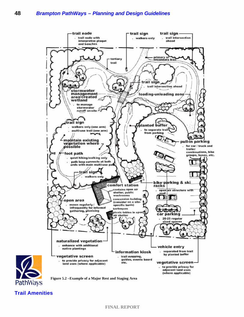
FINAL REPORT
Trail Amenities
48 Brampton PathWays – Planning and Design Guidelines
Figure 5.2 –Example of a Major Rest and Staging Area

Brampton PathWays – Planning and Design Guidelines 49
FINAL REPORT
Trail Amenities

FINAL REPORT
Other Considerations
Brampton PathWays – Planning and Design Guidelines 49
Chapter 6 – OTHER CONSIDERATIONS
6.1 INTERSECTION TREATMENTS
6.1.1 Bike Lanes
Trail approaches to intersections should be carefully designed to encourage the safe and predictable movement of pedestrians, motorists and cyclists. Since intersections are the most likely areas for conflict between various users of the roadway, care should be taken to design and mark the intersection approach such that all users understand and can anticipate the potential movements of other road users.
One of the most common conflicts at intersections occurs between right turning motor vehicles and cyclists proceeding straight through, since it is necessary for these two road users to cross paths. Pavement marking and signing should be installed to encourage such crossings in advance of the intersection, rather than in the immediate vicinity of the intersection. Left turning cyclists must also undertake a similar weaving manoeuvre through vehicular traffic. Cyclists may elect to undertake a “vehicular style” left turn by using the motor vehicle left turn lane, or they may choose to complete a “pedestrian style” turn by proceeding straight through the intersection, then turning left to cross again on the intersecting road.
For the above noted reasons, the bike lane pavement markings should change from a solid to a broken line on the approach to the intersection. Alternatively, though not preferred, the bike lane can be discontinued if there is insufficient pavement width. The bike lane marking should be discontinued at the start of the taper when right turn lanes or channelizations are provided, or otherwise a broken line should be used a minimum of 30 m from a signalized and 15 m from an unsignalized intersection. This allows cyclists to merge with other traffic and prevent right turning motorists from having to cross a through bike lane to make their turn, thereby cutting off cyclists at the intersection. By discontinuing the solid bike lane marking, both the cyclists and motorists are made aware of the fact that they are sharing a common lane and should react accordingly. Figure 6.1 illustrates the recommended pavement markings for this scenario.
Bike lane at intersection – Toronto, Ontario

FINAL REPORT
Other Considerations
50 Brampton PathWays – Planning and Design Guidelines
6.1.2 Off-Road/Boulevard Pathway Crossings at Intersections
One of the most challenging elements of designing and implementing an off-road trail system is how to accommodate trail crossings at signalized and stop controlled intersections as well as at private driveways. As bikeway planners and designers, we are cognizant of the fact that trail users, especially cyclists, do not typically stop, dismount and walk at pedestrian crossings, as required by the Highway Traffic Act. A number of municipalities are attempting to address this challenge in different ways, but many are simply ignoring the issue. In order to establish a recommended guideline to address this issue, the Transportation Association of Canada (TAC) has embarked on a study to develop traffic signal guidelines for bicycles. These guidelines are expected to be completed and available to municipalities in the Spring of 2003. In the meantime, a number of municipalities have proceeded to implement innovative solutions to accommodate trail crossings at intersections. In the Spring of 2002, the City of Toronto implemented an approach to this challenging issue on the north side of Lake Shore Boulevard east of the new Don River pedestrian and cycling bridge. As illustrated in the adjacent photographs, Toronto has implemented special bicycle signals and signage at signalized intersections as well as specific signs at stop controlled or driveway locations that require motorists to yield to trail users. It is recommended that the City of Brampton review the results of the TAC study when it becomes available, and correspond with City of Toronto staff to gauge their experience with bicycle signals in Toronto. Brampton should then develop its own guideline related to this issue and update this document accordingly. It is anticipated that this Brampton guideline will include a recommendation that supports the implementation of some form of crossing solution that gives priority to trail users on off-road and boulevard trails crossing at signalized or stop controlled intersections.
Advanced warning sign to motorists
Bicycle signal
Lake Shore Boulevard at Carlaw Ave.

FINAL REPORT
Other Considerations
Brampton PathWays – Planning and Design Guidelines 51
6.1.3 Mid-Block Crossings
One of the key challenges for a municipality in implementing a connected on and off-road trail network is how to accommodate a trail crossing of a roadway. Ideally, a trail crossing of a roadway should occur at an existing signalized or stop controlled intersection, or if at a mid-block location, by way of a grade separated crossing, such as an underpass or bridge. Unfortunately, these ideal trail crossing solutions can not always be achieved.
The location of the trail and its existing or preferred alignment and desire line for trail users may mean that crossing at an existing or future protected crossing is impractical. In addition, when retrofitting a roadway to accommodate a trail crossing, constructing an underpass or bridge for the trail is not always a feasible solution from both a design and cost perspective.
Many municipalities are now including hydro and abandoned/active rail corridors in their trail networks. Abandoned rail corridors in urban areas are especially suited for multi-use trail systems, with many offering grade separated crossings of major arterial roads. Hydro corridors provide excellent opportunities for linear trail links, but they also result in road crossing challenges, often because they occur at mid-block locations. Where a trail segment crosses a street, mid-block crossings traditionally tend to be avoided. This is largely because a motorist may not expect conflicts with trail users crossing mid-block, and it may be difficult to
Figure 6.1 – Bicycle Lane Adjacent to Combined Through/Right Turn Lane Source: Bikeway Traffic Control Guidelines, TAC, 1997.

FINAL REPORT
Other Considerations
52 Brampton PathWays – Planning and Design Guidelines
satisfy the warrant for either a traffic control signal or a pedestrian crossover.
When a mid-block crossing is necessary, it should be designed to provide advance warning to both motorists and trail users of the impending crossing. The trails should be designed and signed to encourage the user to reduce speed and stop. Grade changes on the trails in advance of the crossing combined with adequate sight distances, signing, textural surface contrast, and bollards should be considered. Mid-block crossings of arterial or collector roads may warrant consideration of a separate traffic signal or a pedestrian crossover.
Figure 6.2 illustrates one example of a typical mid-block trail crossing.
Consideration should also be given to changing the texture/colour/elevation of the roadway itself (in addition to the detail that is paid to the treatment of the approach) to provide drivers with a visual cue to exercise caution.
Raised Crosswalk
Raised crosswalks have been introduced by a number of municipalities, including the City of Vaughan, as a design solution for mid-block crossings. The purpose of a raised crosswalk is to reduce vehicle speeds, improve pedestrian and trail user visibility and reduce the number of pedestrian-vehicle conflicts.
This design treatment is most applicable for local and collector residential streets where the posted speed limit is 50 km/h or less. Figure 6.3 illustrates a TAC recommended guideline for raised crosswalks. Refer to the Canadian Guide to Neighbourhood Traffic Calming1 for more details.
Mid-Block Crossing Warrant
If the trail crossing is within the given distance of a signalized or stop controlled intersection, or a formal pedestrian crossing, trail users should be directed to cross at this location. The following are considered accepted threshold distances for mid-block crossings:
2 Lane Roadway: 60 m from nearest protected crossing 4 Lane Roadway: 120 m from nearest protected crossing
1 Canadian Guide to Neighbourhood Traffic Calming, TAC/ITE, 1998.

FINAL REPORT
Other Considerations
Brampton PathWays – Planning and Design Guidelines 53
Figure 6.2 – Elements of Trail Crossings of Roadways

FINAL REPORT
Other Considerations
54 Brampton PathWays – Planning and Design Guidelines
Figure 6.3 – Raised Crosswalk Design Source: Canadian Guide to Neighbourhood Traffic Calming, TAC/CITE, 1998.

FINAL REPORT
Other Considerations
Brampton PathWays – Planning and Design Guidelines 55
Curb Cuts
Curb cuts provide for increased mobility of trail users with disabilities. However, there are safety concerns surrounding the system-wide provision of such features. The approach to improving accessibility through curb cuts varies between municipalities. Mississauga, for example, provides a narrowing of the curb cut to force trail uses to pass through the adjacent offset gates rather than avoid them. Toronto typically does not install a drop curb on arterial roadways, but they are common on local roadways.
It is recommended that, as a minimum, curb cuts and curb narrowings, possibly combined with raised crosswalks, be implemented on all trail segments that are identified and signed to accommodate wheelchairs. Offset gates may not be required where raised crosswalks are provided.
Pedestrian Refuge Islands
Pedestrian Refuge Islands may be used to protect trail users while crossing multi-lane roadways. The offset design forces trail users to stop and cross each direction of traffic separately. The City of Toronto has developed a warrant for the installation of mid-block pedestrian refuge islands which should be considered for use in Brampton. Their warrant is 100-115 pedestrians per hour over an 8 hour period.
It is recommended that the City of Brampton consider pedestrian refuge islands as an appropriate measure to accommodate a mid-block crossing on a multi-lane road where raised crosswalks are not appropriate.
6.1.4 Railway Crossings
Railway crossings can be extremely dangerous for all trail users and therefore extra caution should be applied to assure their safe operation. It is strongly recommended that appropriate traffic control devices be installed at the intersections of railway tracks and trails. These include:
1. Pavement markings;
2. Signage; and
3. Lift gates.
The aforementioned traffic control devices should be designed and installed in accordance with the Bikeway Traffic Control Guidelines (TAC 1997) and the Manual of Uniform Traffic Control Devices for Canada (TAC 1998).

FINAL REPORT
Other Considerations
56 Brampton PathWays – Planning and Design Guidelines
Careful consideration should be given to the design of at-grade trail crossings of railways. There are approximately 25 crossings on the routes under consideration. Furthermore, it is recommended that trails be designed to cross railways at as close to right angles as possible. In many situations this may require widening of the trail in advance of the crossing, thereby allowing cyclists to reduce their speed and position themselves for crossing at right angles. Rubber track guards are also recommended to assure better friction between bike tires and the pavement, and also to narrow the rail gaps.
Figures 6.4a-d illustrate recommended options for skewed railroad crossings.
6.1.5 Cyclists Crossing at Traffic Signals
Bicycles should be considered in the timing of traffic signals and in the selection, sensitivity and placement of vehicle detection devices wherever there is bicycle traffic. It is very important that loop detectors at signalized intersections are sensitive to bicycles, otherwise cyclists are likely to disobey the unchanged signal. Another alternative is to utilize a pedestrian style push-button to actuate traffic signals for cyclists. These should be located on the curb side, separate from the pedestrian push-button.
Figure 6.4a – Skewed Railroad Crossing Restricted Right-of-Way Width Figure 6.4b –Skewed Railroad Crossing
Unrestricted Right-of-Way Width
Figure 6.4c –Skewed Railroad Crossing Restricted Right-of-Way Width with Gate Control Figure 6.4d –Skewed Railroad Crossing
Unrestricted Right-of-Way Width with Gate Control Source: Bikeway Traffic Control Guidelines, TAC, 1997.

FINAL REPORT
Other Considerations
Brampton PathWays – Planning and Design Guidelines 57
The Transportation Association of Canada (TAC) is currently (2002) developing traffic signal guidelines for bicycles (Project #226). The purpose of this project is to develop a guideline for the safe accommodation of bicycles at signalized intersections. The expected outcome is the acceptance of an exclusive “Bike Signal”, similar to that in use in Quebec and the United States.
6.1.6 Coloured/Textured Pavement
Intersections, crossings and interchange ramps are considered to be the most difficult elements in a trail network. It has been recognized that the application of coloured pavement to illustrate pedestrian and bicycle crossing points at intersections may significantly improve the safety of trail users by informing pedestrians, cyclists and motorists of a trail crossing and the space it comprises. Coloured pavement treatments are widely used in European cities. In North America, a number of cities are now experimenting with coloured pavement and concrete treatments at crossings, Portland, Oregon being one notable example.
It is recommended that the City of Brampton consider the use of coloured and/or textured pavement at high volume crossings. This treatment should be considered at on and off-ramp locations for the 400 series Highways.
6.2 ILLUMINATION
Park and valleyland trails are sometimes illuminated to facilitate their use during evening hours. Lighting is particularly useful during the winter months when children are going to school in reduced daylight hours. Valleys and parks are frequently far enough away from the nearest roadway so that streetlights cannot effectively light these walkways. Therefore, an independent lighting system for these trails is sometimes provided.
The Public Attitude Survey, conducted as part of the Brampton PathWays Master Plan, found that the number one thing residents thought the City could do to improve conditions for walking, jogging, in-line skating or cycling in Brampton was more lighting (11% of respondents). In addition, the same survey found that when asked what, if anything, would encourage residents to use the trail system more often, 9% responded lighting the trail at night (second highest response). It is interesting and important to note, that
Bicycle Detector Dots – Toronto, Ontario
Blue Bike Lane – Portland, Oregon

FINAL REPORT
Other Considerations
58 Brampton PathWays – Planning and Design Guidelines
at the time this survey was undertaken, all existing multi-use trails in the City of Brampton were illuminated.
During the early hours of evening or morning, walkway lighting will afford a degree of safety for pedestrians who use the park system to get to work or school. Lighting trails has been a common component of the existing trail system in Brampton.
Lighting of trails, however, can have a significant effect on the environmental value of many of the valleyland trails in Brampton. The TRCA discourages the use of trail lighting in natural environmental and conservation areas because of the impact on wildlife and vegetation. Input provided by stakeholder focus groups during the development of the Brampton PathWays Master Plan clearly indicated that the provision of lighting is not a major influencing factor in terms of a person’s decision to use an off-road trail segment at night. Residents who indicated they would feel uncomfortable using the trail system at night, would not feel more secure if the trail were lit. Other users indicated they would use the trail system at night, regardless of whether it was continuously lit or not.
It is recommended that the installation of trail lighting for future valleyland trails be discontinued by the City of Brampton. Critical connections through neighbourhoods and areas that serve a greater number of local users should continue to be lit to ensure public safety. Trail gateways should also be lit.
When lighting a trail segment is preferred, it is recommended that the area bordering trails for a width of two to five metres on each side be lighted to levels of at least 1/3 of that for the trail. The level of horizontal illumination needs to be sufficient to easily follow the path, avoid potholes and other obstacles, and to read pavement markings. Adequate vertical illumination should make vertical surfaces such as fences, walls, curbs, trees and shrubs clearly visible. The lighting system as a whole should:
• enable trail users to see other trail users;
• enable trail users to read signs;
• allow motorists to see trail users where the path intersects a road or is in close proximity to a road; and
Example of Brampton Trail Lighting

FINAL REPORT
Other Considerations
Brampton PathWays – Planning and Design Guidelines 59
• provide adequate illumination along the entire length and width of the trail.
Lighting of hazards or areas that are potentially hazardous to cyclists or in-line skaters is recommended. This could include:
• intersections with other trails or roads;
• sharp horizontal and vertical curves;
• steep grades;
• ramps to structures;
• portals of tunnels;
• places where clearance to obstructions is minimal;
• areas where pedestrian volumes are high;
• locations with special security issues; and
• special facilities such as stairs and multi-unit bicycle parking facilities.
Placement of the lighting poles must be carefully considered. The minimum clear-zone as described in section 2.1.3 should be applied to the placement of lighting poles. Signs should be installed in accordance with roadway signage standards and be placed so that they are well lit. Figure 6.5 illustrates the recommended placement of lighting at a trail crossing.
It is also important to ensure that tree branches and other obstacles do not obstruct the passage of light. Therefore, periodic inspection and pruning of tree growth is necessary.

FINAL REPORT
Other Considerations
60 Brampton PathWays – Planning and Design Guidelines
6.3 BARRIERS
A barrier may be required along the trail for a number of reasons: to protect the trail, the user or the natural environment. Most commonly, fence or railing type barriers are provided to protect users from dangerous situations or to discourage access to sensitive areas.
To prevent access by unauthorized users such as motor vehicles, barriers should be installed at the trail entrances. Barriers must be clearly marked and visible, otherwise they can become a hazard to trail users. Trailside signage alerting trail users of the upcoming barriers should be appropriately located to provide adequate time to slow down and/or stop as required.
Suitable barriers associated with trails are bollards, rails, gates, fences and natural barriers. Materials suitable for this type of construction generally include wood, metal pipe or landscaping employing large stones.
• Bollards should be located at trail access points where vehicle access must be restricted. Where it is required that maintenance or emergency vehicles have access to trails, a collapsible or knock-down bollard is a suitable
Figure 6.5 – Lighting for a Trail Crossing a Street Source: MTO, Ontario Bikeways, Planning and Design Guidelines. Downsview, 1996
Example of Bollards – City of Brampton

FINAL REPORT
Other Considerations
Brampton PathWays – Planning and Design Guidelines 61
alternative. In a natural situation, timber bollards are preferred; metal is suited to urban environments.
• Offset gates can be used as a trail traffic calming measure, particularly at busy intersections. Offset gates should be designed to provide uninterrupted through access for bicycles equipped with trailers. In addition, they should be removable by trail management staff to allow access for maintenance vehicles. Figure 6.6 illustrates a typical offset gate design.
• Railings and fences are required to protect the user from a dangerous situation, and should be constructed to conform to local building codes. Timber or stone construction is best suited to natural situations while urban, heavy use areas can be metal or a combination of wood, metal and in some situations stone.
• Landscape treatments, including stone barriers, can provide a natural form that can successfully deter undesired access.
6.4 CATCHBASIN GRATES
Catchbasin grates and utility covers are potential obstructions to cyclists, as well as in-line skaters. Therefore, bicycle-safe grates should be used, and grates and covers should be located in a manner which will minimize severe and/or frequent manoeuvring by the cyclist. When new curbed roadways are constructed and/or rehabilitated, curb face inlets should be
Figure 6.6 – Typical Offset Gate Design ..
Source: Marshall Macklin Monaghan, 2000.
Example of Offset Gates – City of Brampton

FINAL REPORT
Other Considerations
62 Brampton PathWays – Planning and Design Guidelines
considered to minimize the number of potential obstructions. Catchbasin grates and utility covers should be placed or adjusted to be flush with the adjacent pavement surface.
Catchbasin grates with slots parallel to the roadway, or a gap between the frame and the grate, can trap the front wheel of a bicycle, causing loss of steering control. If the slot spacing is wide enough, narrow bicycle wheels can drop into the grates. Conflicts with grates may result in serious damage to the bicycle wheel and injury to the cyclist. These grates should be replaced with bicycle-safe, hydraulically-efficient versions.
6.5 STAIRWAYS WITH SIDE RAMPS
Staircases are a nuisance to cyclists, and in extreme cases can become a barrier to cycling. New staircases should be designed with a channel for bicycles, and existing staircases should be examined for opportunities for retrofitting. Often, a concave or channel-shaped ramp on the side of the staircase will allow cyclists to roll their bicycle up or down while walking up the stairs.
6.6 PATHWAYS BRIDGES
There are typically two basic types of bridges, linear-type or ramped-type bridges. The approach paths of a flat or linear-type bridge do not ramp significantly. This type of bridge crosses over travel barriers, such as waterways, that are lower in elevation than the trail. The approach paths of a ramped-type bridge are sloped to gain elevation. This bridge type crosses barriers, such as a railway, that are at the same elevation or higher than the trail.
In general, a linear-type bridge is preferable because it is the simplest to build and has a flat runout. This ensures access for all trail users. Space limitations and increased heights may require ramp grades as steep as a maximum of 8 percent. This can cause excessive exit speeds, which are especially dangerous if the end of the bridge is located at an intersection. In these situations, curved ramps should be used. Wherever possible, ramps should be elliptical or circular rather than being interrupted by 180 degree turns at landings. In addition, bridge approaches should not be located near intersections, both road/trail and trail/trial, or where visibility is limited.
Bridges should be 0.6 m wider (0.3 m wider on each side) than the trails they are serving, to provide adequate side clearance for the railings. They should also be wide enough and strong enough to support maintenance vehicles where
Stairway with Side Ramp – Oakville Heritage Trail

FINAL REPORT
Other Considerations
Brampton PathWays – Planning and Design Guidelines 63
required. An immovable bollard located at the centre of each approach can be used to prevent heavy vehicles from crossing a light duty bridge.
The bridge travel surface should be a non-slip material. Untreated wooden or flat metal surfaces become slippery when wet or icy. Bridge slats made of self-weathering steel with raised dimples for traction have been used successfully. Open metal grating, on the other hand, is noisy and difficult to travel on by in-line skaters.
Bridges less than 3.3 metres wide should not be configured for riding cyclists as part of a high volume multi-use path. Warning signage and centre line bollards can be used to slow cyclists down and alert them to a constricted bridge crossing ahead. In some cases, it may be necessary to sign the bridge as a pedestrian only structure, and request that cyclists walk their bicycles. It is recognized, however, that cyclists are unlikely to obey this signage, so this measure should only be used in extreme circumstances.
6.7 ON-ROAD CYCLING FACILITIES ON BRIDGE STRUCTURES
The key consideration in designing bicycle facilities across bridges and through interchanges is the safety of cyclists. The separation of cyclists from motor vehicle traffic, either through pavement markings or fully separated facilities, is often recommended to reduce the potential for conflict between these two types of road users, especially on arterial and collector roads.
The width of bridge structures tends to be significantly less than the right-of-way width of the abutting roadway, typically only providing sufficient width for the travelled lanes plus a raised sidewalk. Hence, these types of structures tend to constrict the flow of pedestrian and bicycle traffic. This section serves to review the needs of cyclists, and the design considerations associated with bridge structures
6.7.1 Design Standards
MTO Bikeways Planning and Design Guidelines (Draft, 1996)
The following is an excerpt from the MTO Bikeways Planning and Design Guidelines related to accommodating cyclists on existing bridges:
Typical PathWays Bridge – City of Brampton

FINAL REPORT
Other Considerations
64 Brampton PathWays – Planning and Design Guidelines
To allow cyclists to cross an existing bridge safely, the structure may require alterations to provide adequate width for all bridge users. A bikeway can be routed across the bridge in one of three ways:
a. creating a bike lane or shoulder bikeway on the travelled way;
b. reserving a sidewalk for cyclists only, or for shared use with pedestrians if there is adequate width; or
c. widening the roadway to permit shared use of the right lane by motor vehicles and bicycles.
The creation of a bike lane on a bridge is an option if the bridge has shoulders, or if the traffic lanes are wide enough to permit the creation of a wide curb lane to accommodate bicycles on the travelled way.
Routing a bikeway onto a sidewalk may be the only option available for getting bicycle traffic across a bridge. This is possible under the following conditions:
• A sidewalk intended for use by cyclists must be furnished with protective fence/barrier wall at least 1.4 metres high.
• On a bridge with two sidewalks, both sidewalks may be transformed into bikeways if they are wide enough to accommodate pedestrians as well, or if there is no pedestrian traffic or an alternative pedestrian walkway can be provided.
• On a bridge with two sidewalks, one sidewalk may be reserved for cyclists if the bridge is used very little by pedestrians. Before assigning a sidewalk to each user group, it is important to study the manner in which cyclists and pedestrians will gain access to their respective sidewalks, and to ensure a route which meets all bikeway guidelines.
• On a sidewalk shared by cyclists and pedestrians, the outer corridor should be reserved for pedestrians especially when the cyclists are to return to the roadway.

FINAL REPORT
Other Considerations
Brampton PathWays – Planning and Design Guidelines 65
The addition of a cantilevered bikeway or pedestrian path to replace a sidewalk converted to a bikeway on a bridge structure is the best solution when creating a bike lane is impossible or when routing a bikeway onto a sidewalk would compromise safety. However, the structure of the bridge is the determining factor in whether or not a cantilevered system can be installed. Since the construction of a cantilevered bikeway entails major and relatively expensive work, it should be preceded by an evaluation of the traffic volumes expected over the long term. Consideration should also be given to the different uses that could be made of the bikeway (cyclists, pedestrians, wheelchairs, infant strollers, etc.).
Aside from the characteristics of the bridge, other factors must be analyzed before building a cantilevered addition to the roadway:
• It must be decided whether to build a unidirectional facility on each side of the roadway, or a single bi-directional facility on one side. Unidirectional facilities are generally easier to provide access to at the ends of the bridge.
• Ideally, a bi-directional overpass should be reserved for use by cyclists only. If it must be shared, users must be informed by means of appropriate signage. As on a sidewalk, the outer corridor should be reserved for pedestrians.
• Care must be taken to provide a bikeway surface which has friction characteristics adequate to meet a cyclist’s stopping and turning needs. Steel grate decks/surfaces are not acceptable. Wood planks may be allowed; since wood can be very slippery when wet, consideration should be given to providing rough cut lumber or adding a skid resistant covering to minimize slippage when wet.
Retrofitting a bike ramp beside existing stairs at a grade separation, or the addition of steps and a ramp, may permit cyclists to gain more direct access to an

FINAL REPORT
Other Considerations
66 Brampton PathWays – Planning and Design Guidelines
existing bridge to either walk or ride on the bridge across some path barrier.2
Although the above noted guidelines were not formally adopted by MTO, they are recommended as a reference guide for the City of Brampton.
Canadian Highway Bridge Design Code
The design of new structures or the modification of existing bridges will soon be required to comply with the standards of the Canadian Highway Bridge Design Code. The following is an excerpt relating to the structure geometry:
Roadway and sidewalk widths, curb widths and heights, together with all other geometrical requirements not specified in the Code, shall comply with the standards of the Regulatory Authority [MTO Geometric Design Manual], or in their absence, with the TAC Geometric Design Guide for Canadian Roads.
Sidewalks and cycle paths shall be separated from traffic lanes by a barrier or guiderail, or by a curb having a face height of at least 150 mm and a face slope not flatter than one horizontal to three vertical. Sidewalks and cycle paths not so separated shall be designed as part of the roadway.3
As noted the Canadian Code is currently under review. Until it is adopted, the standards of the Ontario Highway Bridge Design Code remain in effect.
Ontario Highway Bridge Design Code
It is important for the City of Brampton to note that:
This code governs the design, evaluation and structural rehabilitation design of highway bridges in the Province of Ontario with individual spans less than 150 m in length. Provisions are included for the design of pedestrian bridges, retaining walls and
2 Ontario Bikeways Planning and Design Guideline, Ministry of Transportation Ontario, March 1996. 3 CAN/CSA-S6-00 Canadian Highway Bridge Design Code, Section 1.6.2.1

FINAL REPORT
Other Considerations
Brampton PathWays – Planning and Design Guidelines 67
highway accessories of a structural nature such as barriers, poles and sign supports.4
The following are excepts from the Ontario Highway Bridge Design Code.
Traffic Lanes – The number of traffic lanes shall correspond to those of the approach roadway. Traffic lane widths shall conform to the manual, Geometric Design Standards for Ontario Highways. The minimum and maximum lane widths for traffic lanes other than ramps shall be 3.00 m and 3.75 m, respectively.5
Side Clearances – The side clearance (SC) shall be as specified in Table 1-5.2.3.3 (a) and (b) for urban and rural structures, respectively.6
Bicycle Lanes – When required, bicycle lanes shall be incorporated in the side clearance corridors within the roadway. The bicycle lane shall be 1.50 m wide and shall have a 0.50 m side offset clearance to both the curb or barrier and the adjacent traffic lane. When bicycle lanes are incorporated in the bridge cross-section, the side clearances shall be the greater of 2.50 m or the side clearance as specified in Table 1-5.2.3.2 (a) or (b).7
Sidewalks – Pedestrian sidewalk shall be used only where pedestrian traffic requires their use. Sidewalks shall be a minimum of 1.50 m and a maximum width of 2.50 m unless otherwise approved; and shall conform to the requirements of Table 1-5.2.3.2 (a) or (b). For urban arterials with vehicular speeds greater than 75 km/h, or where sidewalks are located adjacent to roadways where type PL3 barriers are warranted in accordance with Section 5 [Barriers and Highway Appurtenances], a configuration of separate roadway and sidewalk may be used as shown in Figure 1-5.2.3 Side Detail C. The minimum sidewalk width in these cases shall be 1.75 m.8
4 Ontario Highway Bridge Design Code, Section 1: General Provisions 5 ibid., Section 1-5.2.3.2 (a) 6 ibid., Section 1-5.2.3.2 (b) 7 ibid., Section 1-5.2.3.2 (c) 8 ibid., Section 1-5.2.3.3 (b)

FINAL REPORT
Other Considerations
68 Brampton PathWays – Planning and Design Guidelines
Table 1-5.2.3.3 (a)
Table 1-5.2.3.3 (b)
Source: Ontario Highway Bridge Design Code

FINAL REPORT
Other Considerations
Brampton PathWays – Planning and Design Guidelines 69
The minimum bicycle rail height according to the code [Section 5-4.1.3.2] is 1.375 metres; however a design of 1.4 metres should be utilized.9 Section 5-4.5.3: Bicycle Barriers outlines the following:
• Bicycle barriers or railing systems shall be incorporated in a bridge design only when bicycle ways are delineated on the bridge. Bicycle barriers shall be used only at the structure edge or fascia.
• Barriers or railings shall be designed for safety and continuity. The barrier or rail heights shall be in accordance with Clause 5-4.1.3.2.
9 Ontario Bikeways Planning and Design Guideline, Section 5.5.2
Source: Ontario Highway Bridge Design Code

FINAL REPORT
Other Considerations
70 Brampton PathWays – Planning and Design Guidelines
Continuous rub rails shall be provided at a height of 1.05 m above the bicycle riding surface. The clear spacing of rail elements in railing systems shall not be greater than 250 mm for rails parallel with the deck and 150 mm for vertical balusters. If a railing system employs rails parallel to the deck and vertical posts and balusters, the rail spacing requirements shall apply to one or the other, but not to both. The clear spacing between the deck and the lowest horizontal rail shall not be greater than 200 mm.10
The design and selection of traffic barriers should conform to Section 5-4: Barriers of the Ontario Highway Bridge Design Code.
10 Ontario Highway Bridge Design Code, Section 5-4.5.3
Source: Ontario Highway Bridge Design Code

FINAL REPORT
Other Considerations
Brampton PathWays – Planning and Design Guidelines 71
Lane Widths
The design guideline for lane widths on paved urban roadways are set out in the Geometric Design Standards for Ontario Highways (GDSOH) and outlined in Table 6.1.
The GDSOH submits that research indicates that lane widths greater than 4.0 m may lead to confusion and improper lane use in congested urban environments and may encourage unsafe passing manoeuvres in rural environments. In general, it has been concluded that a wider lane will provide a greater level of safety than a narrower lane; however, the weight of empirical evidence indicates that there is little safety benefit to be derived by widening lanes beyond 3.3 m, and that widening beyond 3.7 m may be to the detriment of safety (except for widened lanes on curves and shy distances to curbs).11
6.7.2 Other Considerations
Signage
Where inadequate bikeway width exists on a structure, clear and effective signage must be provided to warn cyclists of the restricted road width. In addition, if lanes or cross section are reduced between the abutting roadway and the bridge structure, “pavement narrows” signage should be used to inform both cyclists and drivers of the change in available width.
11 Geometric Design Guide for Canadian Roads, TAC, 1999.
Table 6.1 – Lane Widths on Paved Urban Roadways
Traffic Volume (AADT) Design Speed > 6000 3000 – 6000 2000 – 3000 1000 – 2000 400 – 1000
80 3.75 3.75 3.5 3.5 3.25 70 3.5 3.5 3.5 3.5 3.25 60 3.5 3.5 3.5 3.25 3.25 50 - - 3.25 3.25 3.25 40 - - - 3.25 3.25
No adjustments for truck percentages are required. Curb clearance from the edge of the lane shall be 0.25 metres. Source: Geometric Design Standards for Ontario Highways, MTO, pg. 12.

FINAL REPORT
Other Considerations
72 Brampton PathWays – Planning and Design Guidelines
Liability
It is the duty of the roadway authority to provide safe roadway conditions to all legal users, including cyclists and pedestrians unless prohibited. Therefore, provisions should be made to ensure that cyclists and pedestrians are accommodated on all structures, either through exclusive bike lanes and sidewalks or through the designation of a wide multi-use trail in place of the sidewalk.
6.8 TRAIL UNDERPASSES
In many cases, an underpass may be the preferred solution to continue a trail or path under a highway. Adequate horizontal and vertical clearance must be provided to ensure comfort and safety to all users. Minimum recommended dimensions for any trail underpass should be 3.0 m for both vertical and horizontal. When these dimensions are not feasible, adequate signage should be provided to inform all trail users. Signage options include “low clearance”, “trail narrows”, “cyclists dismount” or “reduce speed” depending on site-specific concerns. Lighting, grades, approaching curve design, visibility and drainage should be carefully considered, and are discussed in other sections of this document.
6.9 CYCLING AND TRANSIT
Improving the cycling-transit link is an important part of making cycling a part of daily life in the City of Brampton. Linking cycling with Brampton Transit buses will overcome barriers such as lengthy trips, personal security concerns and riding at night or in poor weather. This link also enables cyclists to reach more distant areas across the City, and increases transit ridership on weekends and holidays.
The cycling-transit link can also make access to transit less expensive. In suburban neighbourhoods, population densities are often too low to offer transit service within the typical walking distance of 500 metres of every commuter. Within the last 20 years, many transit agencies built expansive motor vehicle park-and-ride lots or centralized depots as an alternative to costly feeder bus service. Many of these facilities are within easy cycling distance, provide opportunities to increase cycling and transit ridership and reduce taxpayer costs, traffic congestion and air pollution.
A key approach to improve the cycling and transit link in the City of Brampton is to equip a number of existing buses with bicycle carriers for a trial period and promote the service
Typical Trail Underpass – City of Brampton
Bike Racks on Buses – Seattle, Washington

FINAL REPORT
Other Considerations
Brampton PathWays – Planning and Design Guidelines 73
through the media, including the City’s website and promotional material. Routes that connect residential neighbourhoods with key destinations in the City, including parks and commercial centres should be included in the trial.
Therefore, it is recommended that the City of Brampton enter into discussions with Brampton Transit to develop and implement a bike racks on buses trial program. In addition GO Transit and Brampton Transit should be encouraged to provide secure bicycle parking at transit centres, and that the City work with these transit authorities to promote the use of cycling and transit.

FINAL REPORT
Other Considerations
74 Brampton PathWays – Planning and Design Guidelines

FINAL REPORT
Brampton PathWays – Planning and Design Guidelines 75
Accessibility
Chapter 7 – ACCESSIBILITY
A wide variety of people with a range of mobility and physical endurance enjoy using outdoor trails. Trail users include people with and without disabilities, children, families and older adults. This chapter examines elements and characteristics that have the greatest impact on access.
7.1 GRADE
In the trail environment, rate of change of grade should not exceed 8.0 percent. A level area of at least 1.5 m in length should be provided at least every 9 m and where there is an abrupt change in the direction of the trail.1
If the rate of change of grade exceeds 13 percent over a 0.61 m (2 ft) interval, the ground clearance of the footrests or antitip wheels may be compromised. Antitip wheels may be placed on the back of some wheelchairs to improve stability and prevent tipping. Even wheelchair users travelling slowly can get stuck if the footrest or antitip wheels get caught.
If the rate of change of grade exceeds 13 percent, the dynamic stability of the trail user can also be significantly compromised, depending on the speed at which the wheelchair user goes through the rapidly changing grade. Dynamic stability is compromised because the negative grade of the first sloped surface causes the wheelchair to rotate forward. However, upon reaching the bottom of the transition, the wheelchair begins to rapidly pitch back as the wheelchair transitions up onto the positive grade of the second sloped surface. Rapid changes in grade can also cause a wheelchair to flip over backward. Any amount of height transition between the two sloped surfaces can further contribute to problems for wheelchair users.
7.2 CROSS-SLOPE
Rapidly changing cross-slopes can cause one wheel of a wheelchair or one leg of a walker to lose contact with the ground, and also can cause pedestrians to stumble or fall. The accessibility guidelines for outdoor recreational trails indicate that cross-slopes should not exceed 2.0 percent.
1 Ontario Building Code, Ministry of Housing, 1990.

Accessibility
76 Brampton PathWays – Planning and Design Guidelines
FINAL REPORT
7.3 PASSING SPACE
Passing space is defined as a section of path wide enough to allow two wheelchair users to pass one another or travel abreast. Accessible passing spaces allow two wheelchairs to pass one another, or for one wheelchair user to turn in a complete circle. Passing spaces are recommended at regular intervals when the trail is narrow for long distances.
Many agencies do not provide guidelines for passing space or passing space intervals because their design width specifications are usually wide enough to allow for users to pass one another.
7.4 TRAIL INFORMATION
People select trails based on a variety of criteria, including personal interest, destination, environment and desired difficulty. Accurate and detailed trail information can provide users with sufficient data to choose routes appropriate to their skill level and desired experience.
Trail users with visual impairments benefit from signs with large lettering, Braille panels, raised lettering or audio boxes that play pre-recorded trail information at the push of a button.
7.5 TRAIL ELEMENTS
The scope and design of trail elements should be appropriate to the conditions of the trail and the needs of the full range of users. The accessibility and safety of a trail might be significantly compromised if trail elements do not provide a level of accommodation consistent with the surrounding environment. For example, a trail user negotiating a paved, level path would expect to use an accessible bridge, not a fallen log, when crossing a stream. When a trail element along an accessible trail is not consistent with the trail’s overall design, a user might be forced to turn back in frustration before reaching his or her destination. If the trail user chooses not to turn back and attempts to continue along the path, he or she risks possible injury.
Trail segments that are identified as wheelchair accessible should include curb cuts to accommodate trail users with disabilities.
FINAL REPORT
Brampton PathWays – Planning and Design Guidelines 77
Accessibility
7.6 BUILT FACILITIES ALONG TRAILS
It is critical that built facilities, such as restrooms and parking lots at the trailhead and along the trail, be accessible, to address the needs of people with disabilities.
Everyone should have the opportunity to experience and enjoy the natural environment. People with and without disabilities, older people, families and children all benefit from being able to enjoy parks and greenways. To the maximum extent feasible, trails should be designed to accommodate the access needs of all designated users. Considering accessibility when designing trails and installing facilities such as wheelchair-accessible toilets, Braille displays in visitor centres and lowered drinking fountains will permit more people to enjoy the outdoors. In addition, providing detailed information about existing path conditions and available facilities can help visitors select trails. Such trail information reduces the likelihood that a trail user will become stranded or endangered, and can improve safety and visitor enjoyment.
The Americans with Disabilities Act Accessibility Guidelines (ADAAG) is a good reference for ensuring equal access to all potential trail users.

Accessibility
78 Brampton PathWays – Planning and Design Guidelines
FINAL REPORT

FINAL REPORT
Brampton PathWays – Planning and Design Guidelines 79
Signage
Chapter 8 – SIGNAGE
Signs along the Brampton PathWays system must communicate various kinds of information to the trail user. Recommended signage has been organized according to the following five functions:
• Designation/directional signs
• Regulatory signs
• Warning signs
• Information signs
• Interpretive signs
Designation/directional signs are used to indicate which facilities constitute the PathWays system. This signage should be placed at changes in direction as well as on long straight sections of the trail at recommended intervals. Directional signs may be used beyond the system itself, in adjacent park space for example, to guide the way to the trail access points. The PathWays logo is prevalent in this signage.
Regulatory signs are intended to control particular aspects of travel and use along the trail. Signage restricting or requiring specific behaviour is not legally enforceable unless it is associated with a provincial law or municipal by-law. Where applicable, it is recommended that authorities discreetly include the municipal by-law number on signs to reinforce their regulatory function.
Warning signs are used to highlight trail conditions that may pose a potential safety or convenience concern to trail users. Examples are steep slopes, railway crossings and pavement changes. These signs are diamond in shape, with a black legend on a yellow background.
Information signs provide general information about the use and identity of the trail, as well as adjacent features. Signs can communicate a single point of information on a standard sign, or a number of points on a large format signboard. Signs at trailheads, access points and gateways may communicate a range of information, including maps. The preferred (as opposed to the regulated) use of the trail is

Signage
80 Brampton PathWays – Planning and Design Guidelines
FINAL REPORT
communicated through “use symbols” where the separation of trail users has been accommodated.
Interpretive signs provide specific information about points of ecological, historical and general interest, as well as current land uses along the trail. They represent a broad range of possible sign formats and applications, depending on the interpretive program and complexity of information to be communicated.
8.1 SIGNAGE FORMATS
Signs associated with the PathWays system should be economical, adaptable and identifiable with the network. To accomplish these objectives while unifying the design and graphic image of the trail, recommended signage has been organized according to the following three formats:
• Standard signs
• Large signboards
• Special applications
The following descriptions introduce the three formats.
Standard signs are aluminum plate blanks with a painted or reflective sheeting surface. The dimensional size of standard signs varies. Recommended signage is generally the same size as typical roadway signs for on-road sections of the network. For off-road sections, where the travel speed of the typical trail user is slower, standard signs are slightly smaller. Simple shapes, bold graphics and concise texts typify the sign message. Standard signs are mounted on or immediately adjacent to the trail on existing posts wherever possible, or on new posts as required.
Large signboards are composite structures generally constructed with a wood or metal frame and a replaceable, updateable message area. Large signboards are associated with trailheads, access points and gateways. The specific format for primary and secondary trailhead signs have been recommended. Large signboards are mounted near the trail, but never immediately adjacent to the travel surface.
Special applications include pavement markings (lines and symbols on the trail surface), as well as unique signage formats associated with information and interpretive signs.

FINAL REPORT
Brampton PathWays – Planning and Design Guidelines 81
Signage
Interpretive signs and features are typically mounted well away from the travel surface of the trail.
8.2 APPLICATION OF TYPICAL SIGNAGE
8.2.1 Designation/Directional Signs
Designation/Directional signs identify the main routes of the PathWays network, and direct trail users along those routes. Designation signs may be used alone or in association with other PathWays information signs. Directional signs (with an arrow) should be mounted directly below a designation sign when needed, to indicate a change in direction or at points where there may be a question of the direction.
The application for these signs would be at minor trail access points, and where a directional change in the trail occurs.
Designation signage may be mounted alone or with the appropriate directional sign at logical, high-visibility locations, ideally where signs can be mounted on both sides of a post.
Designation signs should be regularly spaced every 500 to 700 metres for continuous sections of the trail. Directional signs should be mounted 3 to 5 metres in advance of the
Example of Designation Signage

Signage
82 Brampton PathWays – Planning and Design Guidelines
FINAL REPORT
change in direction, along with the appropriate designation sign.
8.2.2 Regulatory Signs
Graphics for all regulatory signs are guided by MTO’s Ontario Traffic Manual (OTM), TAC’s Manual of Uniform Traffic Control Devices for Canada (MUTCDC) and by Transport Canada regarding railway crossings. These references are an excellent source of information relating to signage applications. All signs referenced in this document refer to the OTM unless otherwise stated. Graphics for regulatory signs relating to other trail use issues, such as littering, parking, dogs, etc. are derived from a variety of other sources.
Stop Signs
Regulatory “Stop” signs (Ra-1) should be posted at all intersections where off-road sections of the trail cross roadways with motor vehicle traffic. This includes all categories of public roadway, as well as park roads, semi-public roads and parking lots.
At driveways, the general rule is that motorists must stop before proceeding onto a roadway, and must yield to pedestrians crossing in front of them on sidewalks. In the same vein, trail users travelling on a multi-use path would have the right-of-way over motorists at a driveway crossing.
At commercial, recreational and industrial driveways with high motor vehicle traffic, in may be necessary to post stop signs for both the off-road sections of the trail and the driveway exit itself to warn motorists of trail users.
Crosswalk and Crossover Signs
According to the Ontario Highway Traffic Act, cyclists must dismount and walk their bicycles across crosswalks and pedestrian crossovers. Municipalities have had varying success with pedestrian crossovers, and this form of control has been replaced with traffic control signals in many communities. Intersection Pedestrian Signals (IPS) or “half-signals” have been implemented in numerous municipalities as an alternative to pedestrian crossovers. A pedestrian actuated button requires posting of a sign such as the “Pedestrians Must Push Button to Receive Walk Signal” regulatory sign (Ra-13). Consult the MTO Ontario Traffic
Ra-1
450 mm x 450 mm
Ra-4/4t
600 mm x 750 mm/ 450 mm x 600 mm

FINAL REPORT
Brampton PathWays – Planning and Design Guidelines 83
Signage
Manual for further information on pedestrian crossings and pedestrian crossovers.
Signs and Pavement Markings for Exclusive Bike Lanes
Exclusive bike lanes are a portion of a roadway or shoulder which is designated for the exclusive use of cyclists by roadside signage, lane lines and pavement symbols. Bike lanes are typically one-way facilities located on both sides of a bi-directional roadway.
Regulatory “Reserved Bicycle Lane” signs (Rb-84A) should be posted along exclusive bike lanes. Signs should be posted 10 metres beyond a roadway intersection at the beginning of an urban block. A maximum spacing for 600 x 600 mm signs is recommended at 90 metres for urban applications. Signs for exclusive bicycle lanes should be designated by a regulatory by-law for permanent use.
Exclusive bike lanes are separated from other roadway travel lanes by a continuous white pavement marking, identical to roadway lane lines. It should be emphasized that solid lines do not indicate that cyclists are restricted to bike lanes. On the contrary, cyclists are free to travel in other lanes as well. Bike lane lines, as well as the recommended arrow, text and bicycle symbols applied directly on the roadway surface, serve to reinforce the exclusive right of use of a bike lane by cyclists. Bike lane lines should be broken (1.0 m long with 1.0 m spaces) to indicate that cyclists and motorists should merge, as required, before reaching an intersection. A 15.0 m broken line is used in advance of a unsignalized intersection, and a 30.0 m broken line is applied in advance of a signalized intersection. Bike lane lines should be discontinued altogether through intersections. Further detail on pavement markings for bike lanes can be found in TAC publication “Bikeway Traffic Control Guidelines for Canada.
Railway Crossing Signboards
The Railway Crossing sign (RA-6 – MUTCDC) indicates to trail users that they must yield the right-of-way, stopping if necessary, before entering the railway crossing area, and must not proceed until it is safe to do so. The Railway Crossing sign is in the form of an “X”. Both cross pieces of the “X” are 1200 mm by 200 mm and they intersect at a right angle.
The supplementary tab sign (RA-6S – MUTCDC) must be used with the Railway Crossing sign where there are two or more tracks at the crossing. This tab sign is in the form of an
Rb-84A
600 mm x 600 mm

Signage
84 Brampton PathWays – Planning and Design Guidelines
FINAL REPORT
inverted “T”, where the minor leg displays a numeral corresponding to the number of tracks, and where the major leg graphically depicts a railway track.
The “Railway Crossing Ahead” warning sign (Wc-4) should be posted 30 metres in advance of every railway crossing, even if the railroad crossing is protected by signals, gates or railway personnel.
Interdictory and Permissive Symbols
An interdictory symbol is comprised of a circular red ring with a diagonal red stroke through the centre of a black on white central symbol. An interdictory symbol indicates that whatever activity is depicted is prohibited.
A permissive symbol is comprised of a circular green ring surrounding a black on white central symbol. A permissive symbol indicates that whatever activity is depicted is permitted.
It is recommended that future requirements for regulatory signs be based on the square, white-background standard with the interdictory or permissive symbol described above. These signs are bold, uniform and non-textual so that they can be understood by trail users with a range of language and colour-differentiation abilities.
Specifications
Format: Standard sign reflective sheeting on aluminum plate.
Background colour: White
Text, symbol colour: Black, red or green
8.2.3 Warning Signs
Warning signs are used to highlight trail conditions that may pose a potential safety or convenience concern to trail users. Examples are steep slopes, railway crossings and pavement changes. Generally, these signs are diamond in shape, with a yellow background. More detail can be found in the Ontario Traffic Manual – Book 6: Warning Signs.

FINAL REPORT
Brampton PathWays – Planning and Design Guidelines 85
Signage
Specifications
Format: Standard sign reflective sheeting on aluminum plate.
Background colour: Traffic yellow
Text, symbol colour: Predominately black
Mounting location: Mount sign 5 to 10 metres from the hazard if 30 metres of uninterrupted view is provided, or in the case of advance warning, 30 metres in advance of the hazard.
Chevron [Wa-9]
Use to indicate a sharp or fall-away curve. Mount bottom of sign 1.0 m above grade. Use individually or in multiples as required.
Low Clearance [Wa-26]
Use to indicate headway clearances of less than 3.0 m. Show dimensions in metres to the nearest tenth of a metre.
Wa-9
450 mm x 600 mm
Wa-26
600 mm x 600 mm

Signage
86 Brampton PathWays – Planning and Design Guidelines
FINAL REPORT
Pavement Narrows [Wa-28]
Use to indicate where a trail narrows by greater than one quarter of its typical continuous width.
Hazard Marker [Wa-33x]
Use to highlight the presence of objects within the trail right-of-way that pose a potential safety threat to passing trail users or would not be obvious on their own. Utility poles, the edges of tunnels and unmoveable objects within the travel surface or the clearing width of the trail are examples that should be marked.
Bicycle Crossing/Trail Crossing
It is recommended that the “Pedestrian and Bicycle Crossing Ahead” sign (WC-46, TAC1) be used to warn motorists of trail crossings rather than the Bicycle Crossing sign (Wc-14), which only shows a bicycle symbol. For on-road applications, mount 30 to 50 metres in advance of the actual trail crossing.
The Crossing supplementary tab sign (WC-7S, TAC) should be used to convey the meaning of the Pedestrian and Bicycle Crossing Ahead sign.
1 Bikeway Traffic Control Guidelines for Canada, TAC, 1998.
Wa-28
750 mm x 750 mm
Wa-33L
300 mm x 900 mm
WC-46 / WC-7S
600 mm x 600 mm/ 600 mm x 300 mm

FINAL REPORT
Brampton PathWays – Planning and Design Guidelines 87
Signage
8.2.4 Information Signs
Information signs help trail users be more aware of important PathWays amenities and locations of community safety infrastructure. These signs should typically indicate locations of telephones, washroom and change facilities, and places to obtain refreshments and water. Their double post frames provide for a maximum sign canvass of 1.2 m by 1.8 m.
8.2.5 Interpretive Signs
Interpretive signs provide specific information about points of ecological or historical interest, as well as current land use along the trail. They represent a broad range of possible sign formats and applications, depending on the interpretive program and complexity of information to be communicated. Their double post frames provide for a maximum sign canvass of 1.2 m by 1.8 m.
Example of Information Signs

Signage
88 Brampton PathWays – Planning and Design Guidelines
FINAL REPORT
8.3 PAVEMENT MARKINGS
Markings on the pavement are a major element in any system of traffic control. Pavement markings serve a variety of functions, including lane definition, separation of opposing flows, passing control, lane usage and designation, pedestrian crosswalks, stop lines, parking areas plus symbol and word messages. In some cases they are used to supplement the regulations or warnings of other devices, such as traffic signs or signals.
Well-chosen and well-designed pavement markings provide guidance to trail users. Standardization and consistency are essential to provide safe operating conditions. As in the case of all other traffic control devices, markings must be uniform so that they are easily recognized and understood.
It is recommended that longitudinal pavement markings be used on off-road multi-use trails to provide separation between opposing flows of trail users. A centre dashed line (1.0 m lines with 1.0 m spacing) will provide separation while maintaining the provision for passing along the length of the trail.
FINAL REPORT
Brampton PathWays – Planning and Design Guidelines 89
Maintenance
Chapter 9 – MAINTENANCE
The maintenance costs and liabilities involved in the installation of a public trail system are major concerns to a municipality. Effective trail design can decrease maintenance costs and deter liability risks.
9.1 INITIAL DESIGN CONSIDERATIONS
Trail design involves addressing both functional and user requirements, and also maximizes longevity and asset preservation. Design standards, which should be considered to increase the life span of a trail system, include the following:
• Proper vertical elevation to ensure adequate drainage of the base course;
• Sufficient cross-slope to allow for surface drainage;
• Proper drainage structures including culverts, swales, etc.;
• Adequate compaction of the base courses;
• Proper edge construction to ensure the stability of the trail; and
• Special drainage considerations along watercourses.
The construction of all trails and paths must conform to industry standards for composition and load bearing capacity. The standard City of Brampton asphalt trail specification meets the industry standard for the projected use of pedestrians, cyclists and park maintenance vehicles. Regular inspection of the trail construction will also ensure compliance with the asphalt specification and satisfactory trail installation. The life expectancy of all trails will increase when these proper methods of installation are used.
The location of the trail is an important factor when preventing asphalt replacement. The asphalt trail should be kept away from running water or steep slopes that will erode the walkway surface or undermine the base material. Walkway slopes must comply with the 8% maximum slope to reduce the incidence of erosion. The layout of the trail system must be positioned above the two year storm floodline to prevent frequent trail washouts. Culverts to channelize water under the trail will reduce the amount of erosion as well.
Trails should be sloped to either side with a crossfall to facilitate drainage, as described in Section 2.2.3. Ponding on

FINAL REPORT
90 Brampton PathWays – Planning and Design Guidelines
Maintenance
the walkway becomes a problem when the freeze-thaw action of water causes the asphalt to crack and deteriorate. The costs for asphalt repair will be reduced if sufficient surface drainage is provided over the walkway.
9.2 TRAIL MAINTENANCE
There are currently no formal documented maintenance standards in the City of Brampton. Through discussions with the City and members of the Maintenance Committee, the following section outlines current levels of maintenance for the PathWays system.
Off-road and on-road trail maintenance is the responsibility of the Parks and Recreation Division of the Community Services Department and the Works and Transportation Department, respectively. The co-ordination between the two departments ensures consistent maintenance practices. Reciprocal agreements between the departments should also be recognized.
Inspection
Reasonable diligence is required when managing any asset. Trails and their amenities should be inspected on a regular basis (annual audit including structures such as bridges and culverts). These inspections identify hazardous conditions as well as issues related to maintenance, repairs and events of vandalism. Trails should be inspected prior to anticipated peak season where high use is expected – Spring. The City’s Park Pathways/Trail System and Pedestrian Bridges and Underpasses Condition Analysis programs should be continued and expanded to include annual inspections and reporting.
In addition to this annual review that is documented, inspections should occur after a major weather event. City staff should be cognizant of broken limbs on woody plant material, sediment deposits from silt deposit as a result of high water and undermining of trail structures. Extra care should be taken with respect to ensuring sight lines and encroachments are not compromised. Acts of vandalism should be addressed as soon as possible. Ensuring the system is safe and litter free will help promote its use to Brampton residents and community visitors.

FINAL REPORT
Brampton PathWays – Planning and Design Guidelines 91
Maintenance
Trails
Trails are swept once a year, following winter, and prior to special events. The parks department has identified a system of “primary walkways” which receive higher levels of maintenance throughout the year. These trails are typically destination oriented, and are typically sanded and salted within 24 hours after a snowfall. Trails that are not maintained are signed accordingly; however fewer than 12 paths are not maintained.
Trash Clean-Up and Grass Cutting
Trash cans are emptied on a weekly basis in conjunction with the grass cutting. The grass is typically cut down to approximately two inches on either side of the trail.
Lighting
Preventative maintenance is the key to ensure that Brampton’s investments in trail amenities provide for a maximum lifecycle. One such example is the lighting system associated with the network. Like other assets, the lights need regular cleaning and re-lamping. They must also be checked periodically for light levels and anomalies such as ground faults and structural damage.
Vegetation
Vegetation should be routinely cut back since overgrown shrubs and low-hanging branches can obscure signs and pose a hazard to users. Adequate clearance and sight distances should be maintained at driveways and intersections so trail users are visible to motorists. Roots can be controlled by installing root barriers during trail and sidewalk construction to prevent the break-up of the surfaces. Maintenance of vegetation originating from private property should be required through local ordinances.
Surface Maintenance
The common trail surfaces are packed earth, stonedust, asphalt, poured concrete and concrete pavers. Maintenance of a smooth transition joint between surface treatments is critical. Each surface requires specialized maintenance practices; the following is an outline of the different characteristics and the variable frequency of inspection and maintenance that is required.

FINAL REPORT
92 Brampton PathWays – Planning and Design Guidelines
Maintenance
• Packed Earth
Packed earth is susceptible to erosion from overuse, so preventing these conditions is a constant concern. Water must be diverted off the trail surface by means of water bars and sloped surfaces. In natural areas, trails may be closed and re-routed to allow for adjacent vegetation to regenerate. Slopes may be terraced against the affects of erosion with stairs and switchbacks.
Inspection/implementation should be done three times per year, usually spring, summer and fall.
• Stonedust
Stonedust trails are adaptable to many situations. They must be sloped to provide drainage, but can absorb some runoff. They can be stabilized with calcium chloride to prevent erosion and create a hardened surface. Stonedust should not be used on slopes greater than 10%. Maintenance requirements are more frequent for stonedust trails than for asphalt trails. However, regrading requirements and filling potholes are generally less costly and complicated to perform.
Inspection/implementation should be done twice per year in the spring and fall.
• Asphalt
Asphalt trails are most suitable for intense high traffic areas. Asphalt has a life span of approximately eight to ten years. Asphalt requires a sub-base of compacted granular ‘A’. Asphalt trails must be cross-sloped a minimum of two percent to allow for drainage. Asphalt should be used on all slopes greater than 10% to prevent erosion. Drainage swales are required next to asphalt trails.
Inspection/implementation should be done once per year, especially for potholes in the spring.
• Poured Concrete
Concrete that is poured in place requires a sub-base of compacted 19 mm (3/4”) crushed stone. Concrete has a life span of 20 to 40 years, but the individual slabs have a tendency to “step” due to differential settling. This can be minimized through proper grading and compaction.

FINAL REPORT
Brampton PathWays – Planning and Design Guidelines 93
Maintenance
Depending on drainage and the severity of washouts and settling, cracking can occur. Expansion joints can also be problematic to in-line skaters, and can present a tripping hazard to pedestrians.
An annual inspection is required to confirm the integrity of the concrete surface and to make the necessary repairs.
• Concrete Pavers
Most commonly used in urban focal point areas, concrete pavers require installation by skilled contractors on underlying layers of stonedust and compacted granular ‘A’. Pavers must be cross-sloped a minimum of two percent to allow for drainage. While the pavers themselves are durable, they are susceptible to settlement if not constructed properly. Edge restraints must also be properly installed to ensure the integrity of the trail edge.
Inspection/implementation should be done twice per year in the spring and fall.
Trail Bridges
The premature ageing of trail bridges is a significant issue from an asset preservation standpoint. With a replacement cost of more than $8M for trail bridges, the City cannot afford to dismiss or ignore the deterioration of these facilities.
One of the primary causes for bridge deterioration is the use of corrosive de-icers on the trail system. Older, wooden bridges tend to absorb the chemicals, eventually leading to wood rot. Non-corrosive de-icing chemicals should be investigated by the City to prolong the life of all PathWays bridge facilities.
9.3 ASSET PRESERVATION AND REPLACEMENT
The City of Brampton has had a full Outdoor Replacement Program in place since 1998. Parks Operations staff undertake an annual site conditions review of the trails network, and revise the Condition Analysis Map. Trails listed in poor condition are ranked in order of replacement priority. This ranking, along with replacement costs, forms the basis of the long-term budgets prepared by the Outdoor Asset Co-ordinator.

FINAL REPORT
94 Brampton PathWays – Planning and Design Guidelines
Maintenance
9.4 LITTER REMOVAL
Perhaps one of the most distressing tasks in maintenance is collecting the increasing amount of litter in open spaces and along road sides. While the task of litter is usually a municipal responsibility, in recent years it has become common practice to encourage citizens’ groups to assist in litter control and vegetation management. “Adopt-A-Trail” programs are becoming popular activities involving community groups and corporate sponsors.
9.5 LEAF REMOVAL
For many trail users, fallen leaves do not pose a hazard. However, to cyclists and in-line skaters, piles of wet leaves present a serious obstacle when encountered on trails or in roadway gutters. It is difficult for cyclists and in-line skaters to stop on leaves, and falls can occur. Leaves also can hide pot holes, debris and drainage inlets. It is recommended that excessive fallen leaves be removed from the travelled portion of trails and roads as soon as possible to prevent accidents.
9.6 LIABILITY
The risk of liability is significantly reduced if the City provides adequate resources and a co-ordinated program for good trail design, construction, maintenance and repairs, and implements an asset replacement program.
A well constructed trail that is free of potholes, ruts and obstructions allows the trail user to travel safely. Regular inspection and repair will keep the surface in a smooth and level condition. Routine maintenance schedules include the removal of vegetation that obstructs visibility or clearance on the trail.
During the winter months, snow and ice should be regularly removed from the park walkway system. Liability is limited when ice is eliminated due to good drainage design and efficient snow removal schedules.
Signage, as a warning mechanism, could also reduce liability concerns. The PathWays system signage should be designed to warn the trail users of road crossings, steep grades and low clearance underpasses. The ultimate goal for limiting liability is to provide a safe trail system through effective design and maintenance techniques.
Additional information on liability and risk management issues is included in Appendix B.

City of Brampton
Planning and Design Guidelines
APPENDIX A
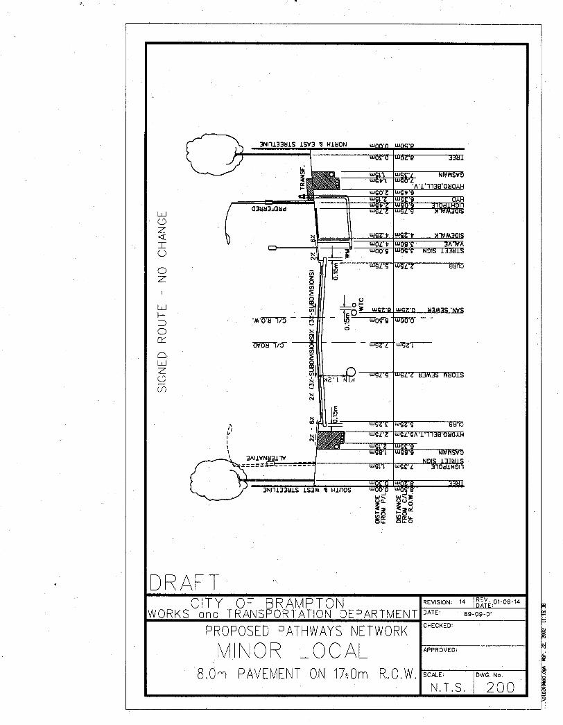


City of Brampton
Planning and Design Guidelines
APPENDIX B


City of Brampton
Planning and Design Guidelines
APPENDIX C

FINAL REPORT
Legislation
Brampton PathWays – Planning and Design Guidelines C-1
Appendix C – LEGISLATION
BICYCLES AND THE LAW IN ONTARIO
The following are excerpts from the Ontario Highway Traffic Act that address cycling, the use of bicycles and the rules of the road. Readers should confirm that legislation stated herein has not been amended since the issuance of this report.
ONTARIO HIGHWAY TRAFFIC ACT
SECTION I. «Bicycle» means a cycle having any number of wheels that is propelled by human power and on which a person may ride:
-«bicycle» includes a tricycle and unicycle but does not include a motor assisted bicycle.
SECTION 44 (17) When on a highway at any time from one-half hour before sunset to one-half hour after sunrise and at any other time when, due to insufficient light or unfavourable atmospheric conditions, persons and vehicles on the highway are not clearly discernible at a distance of 150 metres or less, every motor assisted bicycle, bicycle or tricycle shall carry on the front thereof a lighted lamp displaying a white or amber light and on the rear thereof a lighted lamp displaying a red light or a reflector approved by the Ministry, and in addition there shall be placed on the front forks thereof white reflective material, and on the rear thereof red reflective material covering a surface of not less than 250 millimetres in length and 25 millimetres in width.
R.S.O. 1980, c. 198, s. 44 (17); 1984, c. 61, s. 2 (6).
(18) Every person who contravenes subsection (17) is guilty of an offence and on conviction is liable to a fine of not more than $20.
R.S.O. 1980, c. 198, s. 44 (18); 1983, c. 63, s. 14.
SECTION 46 (2a) No person shall ride a bicycle on a highway unless it is equipped with at least one brake system acting on the rear wheel that will enable the rider to make the braked wheel skid on dry, level and clean pavement.
(2b) In subsection (2a), «bicycle» has its ordinary meaning and does not include a unicycle or tricycle. 1989, c. 54,s. 9(1).
(4) The Lieutenant Governor in Council may make regulations,

FINAL REPORT
Legislation
C-2 Brampton PathWays – Planning and Design Guidelines
(a) requiring vehicles or any type or class thereof to be equipped with brakes or braking systems in addition to the brakes required by subsection (1), (2), (2a) or .(3);
(b) prescribing the standards and specifications of brakes and braking systems or any class or type thereof that are required by this section or regulations made under clause (a); and
(c) exempting any person or class of persons or any class of bicycles from subsection (2a) and prescribing conditions for any such exemption.
R.S.O.1980, c. 198,s. 46(4); 1989,c. 54,s. 9(2,3).
SECTION 57 (5) Every motor vehicle, motor assisted bicycle, and bicycle shall be equipped with an alarm bell, gong or horn, which shall be kept in good working order and sounded whenever it is reasonably necessary to notify pedestrians or others of its approach. R.S.O. 1980, c. 198,s. 57 (5); 1989, c. 54,s. 10.
SECTION 120 (6) No person shall ride a bicycle across a roadway within a pedestrian crossover.1989,c. 87,s. 14.
SECTION 122 (4) When the signal is given by means of the hand and arm, the driver or operator shall indicate his [or her] intention to turn,
(a) to the left, by extending the hand and arm horizontally and beyond the left side of the vehicle; or
(b) to the right, by extending the hand and arm upward and beyond the left side of the vehicle. R.S.O. 1980,c. 198,s. 122 (1-4).
(4a) Notwithstanding clause (4) (b), a person on a bicycle may indicate the intention to turn to the right by extending the right hand and arm horizontally and beyond the right side of the bicycle.1989, c. 54, s. 20.
SECTION 124 (26a) No person shall ride a bicycle across a roadway within or along a crosswalk at an intersection or at a location other than an intersection which location is controlled by a traffic control signal system. 1989,c. 54,s. 22.
SECTION 126 (1) Any vehicle travelling upon a roadway at less than the normal speed of traffic at that time and place shall, where practicable, be driven in the right-hand lane then available for

FINAL REPORT
Legislation
Brampton PathWays – Planning and Design Guidelines C-3
traffic or as close as practicable to the right-hand curb or edge of the roadway.
(2) Subsection (1) does not apply to a driver of a:
(a) vehicle while overtaking and passing another vehicle proceeding in the same direction;
(b) vehicle while preparing for a left turn at an intersection or into a private road or driveway; or
(c) road service vehicle. 1989,c. 54, s. 23.
SECTION 127 (3) Every person in charge of a vehicle on a highway meeting a person travelling on a bicycle shall allow the cyclist sufficient room on the roadway to pass.
(5) Every person on a bicycle or motor assisted bicycle who is overtaken by a vehicle or equestrian travelling at a greater speed shall turn out to the right and allow the vehicle or equestrian to pass and the vehicle or equestrian overtaking shall turn out to the left so far as may be necessary to avoid a collision. 1989, c. 54, s. 24.
SECTION 144 (1) Where a person in charge of a vehicle or on a bicycle or on horseback or leading a horse on a highway overtakes a street car or a car of an electric railway, operated in or near the centre of the roadway, which is stationary for the purpose of taking on or discharging passengers, he or she shall not pass the car or approach nearer than 2 metres measured back from the rear or front entrance or exit, as the case may be, of the car on the side on which passengers are getting on or off until such passengers have got on or got safely to the side of the street, as the case may be, but this subsection does not apply where a safety zone has been set aside and designated by a by-law passed under paragraph 124 of Section 210 of the Municipal Act. R.S.O. 1980, c. 198, s. 144 (1); 1989, c. 54, s. 30 (1).
(2) No person in charge of a vehicle or on a bicycle or on horseback or leading a horse, overtaking a street car or the car of an electric railway, operated in or near the centre of the roadway, which is stationary or in motion, shall pass on the left side of such car, having reference to the direction in which the car is travelling, but this subsection does not apply to a vehicle belonging to a municipal fire department while proceeding to a fire or answering a fire alarm call or where the street car or car of an electric railway is being operated on a highway designated for

FINAL REPORT
Legislation
C-4 Brampton PathWays – Planning and Design Guidelines
the use of one-way traffic. R.S.O. 1980, c. 198, s. 144 (2); 1989, c. 54, s. 30 (2).
SECTION 154 (1) A person riding upon a motor assisted bicycle, a bicycle, a coaster, roller skates, skis, a toboggan, a sled or a toy vehicle shall not attach it or them or himself or herself to a vehicle or street car on a roadway.
(2) No person riding on a bicycle designed for carrying one person only shall carry any other person thereon.
(4) No person shall attach himself or herself to the outside of a vehicle or street car on a roadway for the purpose of being drawn along the roadway. R.S.O.1980, c. 198,s. 154.
SECTION 155 (1) Where sidewalks are not provided on a highway, a pedestrian walking along the highway shall walk on the left side thereof facing oncoming traffic and, when walking along the roadway, shall walk as close to the left edge thereof as possible. R.S.O.1980, c. 198, s.155.
(2) Subsection (1) does not apply to a pedestrian walking a bicycle in circumstances where crossing on the left side of the highway would be unsafe. 1989, c. 54, s. 34.
SECTION 161 (2) The council of a municipality may by by-law prohibit pedestrians or the use of motor assisted bicycles, bicycles, wheelchairs or animals on any highway or portion of a highway under its jurisdiction. R.S.O. 1980, c.198, s.161 (2)
SECTION 190A (1) A police officer who finds a person contravening this Act or any municipal by-law regulating traffic while in charge of a bicycle may require that person to stop and to provide identification of him or herself. 1989, c. 87, s.20
(2) Every person who is required to stop, by a police officer acting under subsection (1), shall stop and identify him or herself to the police officer.
(3) For the purposes of this section, giving one’s correct name and address is sufficient identification.
(4) A police officer may arrest without warrant any person who does not comply with subsection (2). 1989, c. 54, s.41, part.

City of Brampton
Planning and Design Guidelines
APPENDIX D

FINAL REPORT
Glossary
Brampton PathWays – Planning and Design Guidelines D-1
Appendix D – GLOSSARY
Bicycle A vehicle, under the Highway Traffic Act, having two tandem wheels, propelled solely by human power, upon which any person may ride. For the purpose of these guidelines, bicycle includes adult tricycles, tandem rider bicycles, unicycles, but do not include motor assisted bicycles.
Bicycle Facilities A general term denoting provisions made or administered by public agencies to accommodate or encourage cycling, including bikeways, bike parking facilities, lockers, showers, washrooms, etc.
Bicycle Route A designated segment of a bikeway system or network that provides at least minimum width and alignment for bicycle travel. A bicycle route is any on-road or off-road bikeway signed as a "Bike Route". This designation may be established by the jurisdiction having authority through signing or identification on a map.
Bicycle Driver A person riding a bicycle and in control of the direction and speed of the bicycle.
Bike Lane A portion of a roadway, which has been designated by signing and pavement markings for the preferential or exclusive use of cyclists.
Clearance, Horizontal The width required for safe passage of a bicycle driver and bicycle as measured in a horizontal plane. The width is measured from the edge of the essential manoeuvring space to any fixed object capable of injuring or destabilizing a cyclist using the facility.
Clearance, Vertical The height necessary for the safe passage of a bicycle driver and bicycle as measured in a vertical plane.

FINAL REPORT
Glossary
D-2 Brampton PathWays – Planning and Design Guidelines
Commuter Cyclist An individual who frequently cycles over the same or a similar route, and uses a bicycle primarily for travel to and from work, school or shopping.
Cross-Section A diagrammatic presentation of the right-of-way profile which is at right angles to the centre line at a given location.
Child Cyclist For the purpose of determining appropriate bicycle facilities, any person under 13 years of age and usually operating on a bicycle with wheels of a maximum diameter of 600 mm.
Experienced Cyclist A rider assumed to have the physical and judgmental skills needed to safely and comfortably manoeuvre a bicycle in a variety of traffic conditions. Usually considered as an experienced adult cyclist over the age of 13.
Grade Separation Vertical separation of conflicting travelled ways through use of a structure so that traffic crosses without interference.
Groove A narrow longitudinal slot in the riding surface that could restrict the steering of a bicycle wheel, such as a gap between two concrete slabs
Highway A general term denoting a public way for the purpose of vehicular travel, including the entire area within the right-of-way.
Horizontal Signs/ Markings
Markings applied to the pavement surface.
Inexperienced Adult Cyclist
A cyclist 13 years of age or older who may have the judgmental and physical maturity necessary to manoeuvre a bicycle in a variety of traffic conditions, but typically does not feel secure or comfortable riding in all traffic situations.
Motor Vehicle A vehicle that is self-propelled and can convey more than one person.
Multi-Use Trail A facility which allows shared use by bicycles, pedestrians, inline skaters, joggers, and other non-motorized vehicle transportation, usually excluding equestrians in urban areas (by-law), and which generally segregates cyclists and is not a sidewalk.
FINAL REPORT
Glossary
Brampton PathWays – Planning and Design Guidelines D-3
Pavement Marking Painted or applied lines or legends placed on any bikeway/roadway surface for regulating, guiding or warning traffic.
Pedestrian A person whose mode of transportation is on foot. A person "walking a bicycle" is considered a pedestrian.
Recreational Cyclist An individual who uses a bicycle for trip enjoyment, and usually takes relatively short trips at lower speeds. An ultimate destination is of secondary importance.
Right-of-way A general term denoting land, property, or interest therein, usually in a linear orientation, acquired for or devoted to public transportation purposes.
Roadway The portion of the highway, including shoulders, designed for vehicle use.
Rules of the road The Provincial Highway Traffic Act and municipal by-laws contain regulations governing the operation of vehicular and pedestrian traffic.
Shared Roadway/Bikeway A type of bikeway where cyclists and motorists share the same roadway lane.
Shoulder The portion of the roadway outside the edges of the motor vehicle travel lanes, excluding curbs, extending to the top of the front slopes of the ditch, and where motor vehicles could reasonably stop. The shoulders may be paved or unpaved.
Shoulder Bikeway
A type of bikeway where cyclists travel on the paved or surface treated part of a roadway shoulder.
Sidewalk The portion of a highway or street designed for preferential or exclusive use by pedestrians.
Sidewalk with Ramps Sidewalks designed to provide a smooth transition between grades by the use of slanted ramps. Such facilities are typically wider than ordinary sidewalks, so that wheelchair users and those who experience problems walking can be accommodated.
Sight Distance A measurement of the cyclist's visibility, unobstructed by traffic or objects beside a bikeway or multi-use path to the farthest visible point of the bikeway/roadway surface.

FINAL REPORT
Glossary
D-4 Brampton PathWays – Planning and Design Guidelines
Signed Route A type of bikeway where cyclists and motorists share the same roadway lane, and where special signage is installed to emphasize the signed route.
Skew Angle Less than a right angle to a bikeway; generally an oblique angle of 45° or less.
Touring Cyclist An individual who uses a bicycle for long distance travel between towns, cities and villages, and usually carrying baggage on multi-day trips.
Traffic Control Devices Signs, signals or other fixtures, whether permanent or temporary, placed on or adjacent to the travelled way by authority of a public body having jurisdiction to regulate, warn or guide traffic.
Traffic Volume The number of vehicles that pass a given point during a specified amount of time such as an hour, day or year. For example, average annual daily traffic (AADT), and summer average daily traffic (SADT).
Utilitarian Cyclist An individual who uses a bicycle primarily for travel to and from specific destinations such as work, school, shops or recreation centres.
Vertical Signs/Markers Signs mounted on a vertical post to advise vehicle drivers.
Vehicle Any device which is capable of moving itself and a person, or of being moved, from place to place upon wheels. Vehicle includes any bicycle.
Wide Curb-Lane A roadway lane which is wider than a normal vehicle lane for shared use by bicycles and motorized traffic. This curb lane is of such width that a bicycle and motorized traffic can be accommodated side by side in the same lane. This lane is always the through lane portion closest to the curb or the shoulder edge of the road when a curb is not provided.

City of Brampton
Planning and Design Guidelines
APPENDIX E

Brampton PathWays – Planning and Design Guidelines E-1
FINAL REPORT
References
Appendix E – RECOMMENDED REFERENCES
Additional information and standards on bikeway design and other aspects of bikeways may be found by reference to the following documents:
• Ontario Highway Bridge Design Code
• CAN/CSA-S6-00 Canadian Highway Bridge Design Code
• Geometric Design Standards for Ontario Highways, MTO
• Geometric Design Guide for Canadian Roads, Transportation Association of Canada (TAC), 1999
• Trail Planning & Design Guidelines, Toronto and Region Conservation Authority (TRCA)
• Design, Signage and Maintenance Guidelines, Waterfront Trail, 1997
• Bikeway Traffic Control Guidelines, TAC/Marshall Macklin Monaghan Limited, 1997
• TAC/CITE, Canadian Guide to Neighbourhood Traffic Calming, 1998
• Ontario Bikeways Planning and Design Guidelines, MTO, March 1996
• Ontario Manual of Uniform Traffic Control Devices, MTO
• Community Cycling Manual, Planning and Design Guide, Canadian Institute of Planners, 1990
• Guide for the Development of Bicycle Facilities, AASHTO, 1999
• Technical Handbook of Bikeway Design, Velo Quebec, 1992
• Guide to Traffic Engineering Practice, National Association of Road Transport and Traffic Authorities in Australia, 1993
• Sign Up for the Bike, Design Manual for a Cycle- Friendly Infrastructure, CROW, Record 10, The Netherlands, 1993
• Americans with Disabilities Ace Accessibility Guidelines (ADAAG)
• Ontario Building Code, Ministry of Housing, 1990
Also available from Marshall Macklin Monaghan Limited is a comprehensive annotated bibliography consisting of over 250 sources regarding bikeway planning and design.