Embed Size (px)
Citation preview

U.S. DEPARTMENT OF THE INTERIOR U.S. GEOLOGICAL SURVEY
BRECCIA-PIPE AND GEOLOGIC MAP OF THE NORTHEASTERN PART OF THE HUALAPAI INDIAN RESERVATION AND
VICINITY, ARIZONA
By K.J. Wenrich, G.H. Billingsley, and P.W. Huntoon
Pamphlet to accompany MISCELLANEOUS INVESTIGATIONS SERIES
MAPI-2440


CONTENTS
Introduction 1 Geologic setting 2 Structural geology 4
Tectonic overview 4 Deformation of the Paleozoic section 4 Laramide monoclines 5 Late Cenozoic faulting 5 Cenozoic uplift and erosion 6
Breccia Pipes 6 Introduction 6 Structural control of breccia pipes 7 Copper prospects 9 Drilled breccia pipes 10
Ridenour Mine 10 Pipe 253 11 Pipe 243 11 The Mohawk Canyon pipe 11 Pipe 1365 (referred to as the Wate pipe by Union Pacific Resources) 12
Other collapse features with economic potential 12 Collapse feature 493 12 Collapse feature 1102 12 Collapse features 534 and 570 13 Collapse features 531, 546, 557, 571, and 577 13 Collapse feature 232 13 Miscellaneous collapse features 13
Conclusions 14 Acknowledgments 14 Description of map units 14 References cited 17
FIGURES
Figure 1. Figure 2.
Figure 3.
Index map of northern Arizona 1 Geographic map of the northeastern Hualapai Indian Reservation, Arizona 3 Diagrammatic cross sections showing the stages in the development of the Hurricane Fault zone in the western Grand Canyon, Arizona 4
III


INTRODUCTION
The Hualapai Indian Reservation, on the southwestern corner of the Colorado Plateau, is host to hundreds of solution-collapse breccia pipes, as is most of northwestern Arizona. Many of these pipes contain uranium orebodies. Since 1980, four mines in the region (Hack 1, Hack 2, Hack 3, and Pigeon; fig. 1) have produced over 13 million pounds of U30 8. Prior to 1980, 4.2 million pounds of U308 were produced from five mines (Orphan, Hack, Chapel, Ridenour, and Riverview), although most of this ore came from the Orphan Mine (Wenrich, Chenoweth, and others, 1989). The amount of ore produced from the Orphan, Hack 1, Hack 2, Hack 3, and Pigeon (fig. I) ranged between I and 7 million pounds of U30 8 per pipe (Wenrich, Chenoweth, and others, 1989). Despite periods of depressed uranium prices, the breccia pipes commanded considerable exploration activity in the 1980's because of the high-grade uranium deposits (average grade of 0.65% U30 8; Mathisen, 1987) in some of them. Metals such as copper, vanadium, silver, lead, and zinc have also been produced from the mines. In addition,
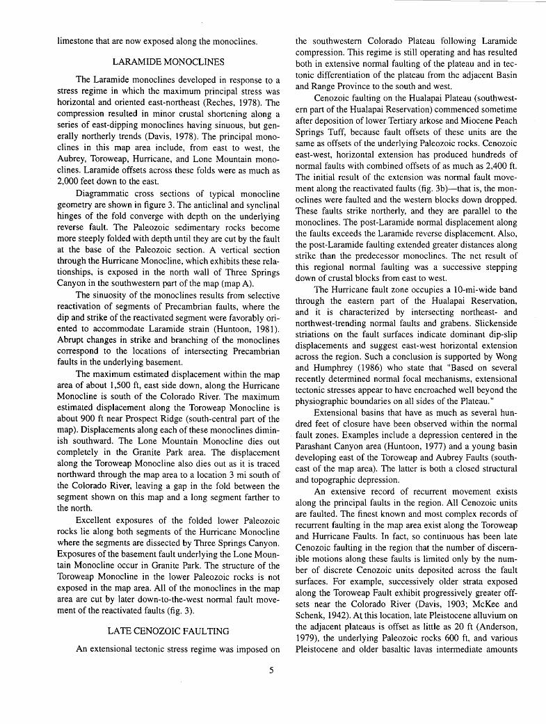
eKingman
BASIN AND RANGE PROVINCE
0 50 100 KILOMETERS ~~~--T-~~~~.~· 0 50 MILES
significant enrichment of nickel, cobalt, and molybdenum can be found in most mineralized breccia pipes. Because of the economic potential for breccia-pipe uranium ore within unmapped terrane in northwestern Arizona, the Hualapai Tribe requested that the U.S. Geological Survey map the Hualapai Indian Reservation and evaluate its mineral potential. This breccia-pipe and geologic map is a product of that request
On the I ,500 mi2 Hualapai Reservation, 857 confirmed and suspected breccia pipes have been mapped; of these approximately 8% show surface expression of mineralized rock, either as recognizable Cu-bearing minerals (most notably malachite, azurite, or brochantite) or as gamma radiation in excess of 2.5 times background. The breccia pipes are genetically and temporally distinct from more modern karst features also found in the Grand Canyon region. Such karst features can be classified into two types of collapse structures: (1) collapses into space created by dissolution of gypsum within the Lower Permian Kaibab Formation and Toroweap Formation, and (2) collapses resulting from a modern system of karst in any of the Paleozoic carbonate
en zu.. z~ lu ~ 0 ~ ~X ~u ~U.I
MARBLE PLATEAU
COLORADO PLATEAU
Figure 1. Index map of northern Arizona showing the locations of plateaus, Hualapai Indian Reservation, mines within breccia pipes, and the San Francisco and Mount Floyd volcanic fields (shown as ruled area) that bury terrane with high potential for mineralized breccia pipes. Numbers refer to the following mines: I, Copper House; 2, Copper Mountain; 3, Cunningham; 4, Grand Gulch; 5, Grandview; 6, Hack 1,2, 3, and old Hack Canyon; 7, Old Bonnie Tunnel; 8, Orphan; 9, Ridenour; IO, Riverview; I1, Savannic; I2, Snyder; 13, Pigeon; 14, Kanab North; 15, Canyon; 16, Pinenut; 17, Hermit; 18, Arizona 1; and 19, Apex.
sections. The modern collapse features in the second group are referred to here as sinkholes. In contrast, the breccia pipes originated through collapse of sedimentary strata into dissolution caverns in the Mississippian Redwall Limestone. The initial dissolution cavities in the Redwall were the product of a regionally extensive paleokarst that developed to various depths in the lower Paleozoic carbonate section during Late Mississippian time when the Redwall Limestone cropped out as a surface of low relief. The pipes stoped upward from the Redwall through the upper Paleozoic section and into lower Mesozoic strata as additional space was created through dissolution of limestone and carbonate cement of wall rocks and down-dropped clasts. A typical breccia pipe in the Grand Canyon region is approximately 300 ft in diameter and extends upward as much as 2,000 ft. The stoping process brecciated the rock, resulting in a breccia core that generally abuts against horizontally bedded, little-disturbed strata. The breccia pipes were formed prior to 200 Ma-the U-Pb age determined (Ludwig and Simmons, 1992) from uraninite within several breccia pipe orebodies. Some breccia pipes are overlain by unbrecciated, infolded strata. Such features without exposed breccia are referred to here as collapse features, because from the plateau surface it is rarely possible to determine whether such a collapse is due to an underlying breccia pipe or to more modern, shallow-rooted dissolution.
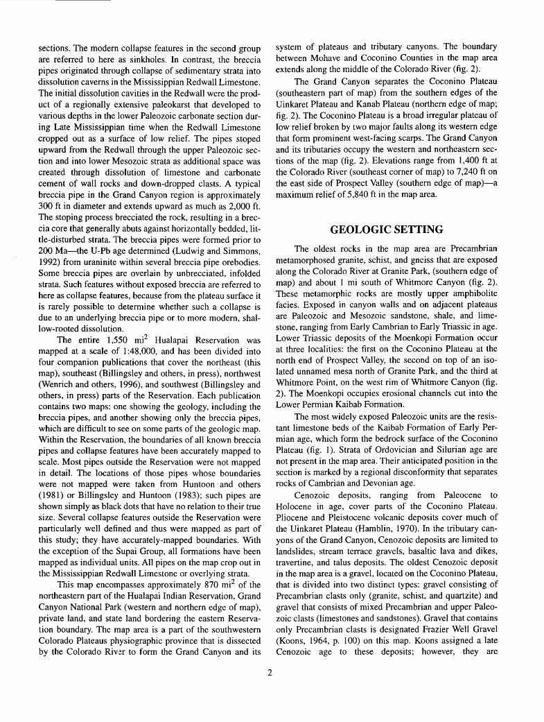
The entire I ,550 mi2 Hualapai Reservation was mapped at a scale of I :48,000, and has been divided into four companion publications that cover the northeast (this map), southeast (Billingsley and others, in press), northwest (Wenrich and others, I996), and southwest (Billingsley and others, in press) parts of the Reservation. Each publication contains two maps: one showing the geology, including the breccia pipes, and another showing only the breccia pipes, which are difficult to see on some parts of the geologic map. Within the Reservation, the boundaries of all known breccia pipes and collapse features have been accurately mapped to scale. Most pipes outside the Reservation were not mapped in detail. The locations of those pipes whose boundaries were not mapped were taken from Huntoon and others (198I) or Billingsley and Huntoon (1983); such pipes are shown simply as black dots that have no relation to their true size. Several collapse features outside the Reservation were particularly well defined and thus were mapped as part of this study; they have accurately-mapped boundaries. With the exception of the Supai Group, all formations have been mapped as individual units. All pipes on the map crop out in the Mississippian Redwall Limestone or overlying strata.
This map encompasses approximately 870 mi2 of the northeastern part of the Hualapai Indian Reservation, Grand Canyon National Park (western and northern edge of map), private land, and state land bordering the eastern Reservation boundary. The map area is a part of the southwestern Colorado Plateaus physiographic province that is dissected by the Colorado Riv·;!r to form the Grand Canyon and its
2
system of plateaus and tributary canyons. The boundary between Mohave and Coconino Counties in the map area extends along the middle of the Colorado River (fig. 2).
The Grand Canyon separates the Coconino Plateau (southeastern part of map) from the southern edges of the Uinkaret Plateau and Kanab Plateau (northern edge of map; fig. 2). The Coconino Plateau is a broad irregular plateau of low relief broken by two major faults along its western edge that form prominent west-facing scarps. The Grand Canyon and its tributaries occupy the western and northeastern sections of the map (fig. 2). Elevations range from I ,400 ft at the Colorado River (southeast corner of map) to 7,240 ft on the east side of Prospect Valley (southern edge of map)-a maximum relief of 5,840 ft in the map area.
GEOLOGIC SETTING
The oldest rocks in the map area are Precambrian metamorphosed granite, schist, and gneiss that are exposed along the Colorado River at Granite Park, (southern edge of map) and about I mi south of Whitmore Canyon (fig. 2). These metamorphic rocks are mostly upper amphibolite facies. Exposed in canyon walls and on adjacent plateaus are Paleozoic and Mesozoic sandstone, shale, and limestone, ranging from Early Cambrian to Early Triassic in age. Lower Triassic deposits of the Moenkopi Formation occur at three localities: the first on the Coconino Plateau at the north end of Prospect Valley, the second on top of an isolated unnamed mesa north of Granite Park, and the third at Whitmore Point, on the west rim of Whitmore Canyon (fig. 2). The Moenkopi occupies erosional channels cut into the Lower Permian Kaibab Formation.
The most widely exposed Paleozoic units are the resistant limestone beds of the Kaibab Formation of Early Permian age, which form the bedrock surface of the Coconino Plateau (fig. I). Strata of Ordovician and Silurian age are not present in the map area. Their anticipated position in the section is marked by a regional disconformity that separates rocks of Cambrian and Devonian age.
Cenozoic deposits, ranging from Paleocene to Holocene in age, cover parts of the Coconino Plateau. Pliocene and Pleistocene volcanic deposits cover much of the Uinkaret Plateau (Hamblin, 1970). In the tributary canyons of the Grand Canyon, Cenozoic deposits are limited to landslides, stream terrace gravels, basaltic lava and dikes, travertine, and talus deposits. The oldest Cenozoic deposit in the map area is a gravel, located on the Coconino Plateau, that is divided into two distinct types: gravel consisting of Precambrian clasts only (granite, schist, and quartzite) and gravel that consists of mixed Precambrian and upper Paleozoic clasts (limestones and sandstones). Gravel that contains only Precambrian clasts is designated Frazier Well Gravel (Koons, 1964, p. I 00) on this map. Koons assigned a late Cenozoic age to these deposits; however, they are
N
l 3~15'--~--~~-.--~ i
( \ \ • "'~ ··,.. \
UINKARET
PLATEAU
COCONINO
To State Hrqhwa)' 66
Figure 2. Geographic map of the northeastern Hualapai Indian Reservation, Arizona.
3
HAVASU PAl INDIAN
RESERVATION
PRIVATE
AND
To Supai
considered in this study to be Paleocene and Eocene because, a few miles southeast of the map area, their stratigraphic position is apparently below gravel that contains Eocene gastropods (Young, 1985). Extensive post-Miocene lag gravel deposits consist of mixed Precambrian and Paleozoic clasts. These deposits were formed by erosion, mixing, and redeposition of older gravel deposits and local erosion of Paleozoic strata.
STRUCTURAL GEOLOGY
TECTONIC OVERVIEW
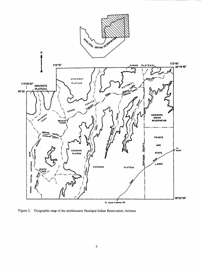
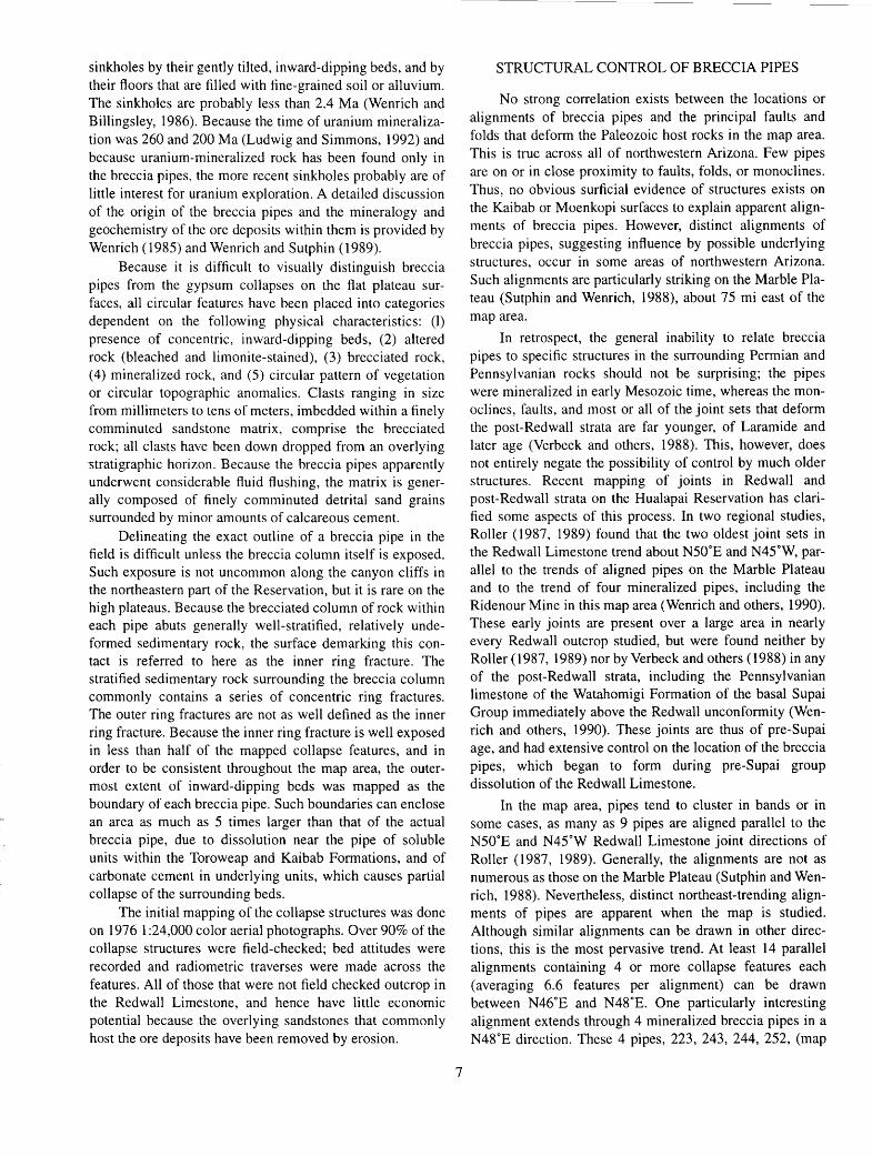
The tectonic history of the southwestern part of the Colorado Plateau can be subdivided into five broad episodes. (1) The Precambrian interval involved a complex succession of crustal accretion, subsidence and sedimentation, and finally uplift accompanied by extensional tectonism that produced a deeply eroded metamorphic complex. (2) Paleozoic through Cretaceous time was characterized by 8,000-13,000 ft of net regional subsidence and comparable sediment aggradation. (3) The Laramide orogeny, herein used to include Late Cretaceous through Eocene events, resulted in north-northeast crustal compression and regional uplift which was accompanied by widespread erosion. ( 4) Regional uplift and erosion has continued since the end of the Laramide orogeny, but the tectonic regime changed to one of east-west regional extension. (5) Erosion that began in late Miocene time helped to produce the Grand Canyon (Young, 1982, 1985; Lucchita, 1990). The dramatic topographic relief associated with it, led to the development of local gravity-tectonic features including large landslides, small gravity-glide detachments and valley anticlines (Huntoon, 1973, 1975; Huntoon and Elston, 1980).
The Hualapai Reservation contains a remarkable record of reactivated faults caused by successive stress regimes imposed on the crust. Normal faults trending north, northeast, and northwest, which have offsets measured in thousands of feet, dominated the late Precambrian structural setting in the region. The Paleozoic and younger rocks are deformed by (I) Laramide monoclines, and (2) late Cenozoic normal faults. The Laramide monoclines developed in response to reactivated faulting of the basement rocks during which reverse motion occurred along selected Precambrian normal faults (fig. 3). The principal late Cenozoic normal faults also followed reactivated Precambrian trends (Walcott, 1890; Huntoon, 1974); however, east-west horizontal extension in the region has also produced many new normal faults and complex fault zones. Normal faulting continues in the region today and has resulted in the development of extensional basins. Such normal faults are common in Quaternary alluvium along the Hurricane and Toroweap Faults and in Quaternary volcanic rocks throughout the region.
A. Laramide folding over reactivated Precambrian fault; Precambrian fault was normal.
WErST ____________________ __
/ ..... /
- /
PRECAMBRIAN / I ROCKS ' ..... / / ..... /
/ ' ' ' ' '
B. Late Cenozoic normal faulting.
PALEOZOIC ROCKS
' ' ' PRECAMBRIAN , , .....
' .....
ROCKS <;:::.~=> ' ,. , .... ... ..... ..... ,
, ' ' ' .... - ,. - ' C. Late Cenozoic configuration after continued extension.
HANGING WALL DIPS ACCENTUATED DURING EXTENSION
LARAMIDE DIPS
'
Figure 3. Diagrammatic cross sections showing the stages in the development of the Hurricane Fault zone in the western Grand Canyon, Arizona. Low-angle conjugate thrust faults are indicated by X's in figure 3a.
DEFORMATION OF THE PALEOZOIC SECTION
The principal tectonic structures that deform the Paleozoic and younger rocks in the Hualapai Reservation formed during horizontal, east-northeast Laramide compression and horizontal, east-west post-Laramide extension. Horizontal, east-west extension is continuing at present. The monoclines that dominate the structural fabric on the Hualapai Reservation developed prior to incision of the Grand Canyon. The Laramide monoclines developed while thousands of feet of Mesozoic and upper Paleozoic rocks still blanketed the region, a conclusion supported by the ductile deformation of the Paleozoic sandstone, shale, and
4
limestone that are now exposed along the monoclines.
LARAMIDE MONOCLINES
The Laramide monoclines developed in response to a stress regime in which the maximum principal stress was horizontal and oriented east-northeast (Reches, 1978). The compression resulted in minor crustal shortening along a series of east-dipping monoclines having sinuous, but generally northerly trends (Davis, 1978). The principal monoclines in this map area include, from east to west, the Aubrey, Toroweap, Hurricane, and Lone Mountain monoclines. Laramide offsets across these folds were as much as 2,000 feet down to the east.
Diagrammatic cross sections of typical monocline geometry are shown in figure 3. The anticlinal and synclinal hinges of the fold converge with depth on the underlying reverse fault. The Paleozoic sedimentary rocks become more steeply folded with depth until they are cut by the fault at the base of the Paleozoic section. A vertical section through the Hurricane Monocline, which exhibits these relationships, is exposed in the north wall of Three Springs Canyon in the southwestern part of the map (map A).
The sinuosity of the monoclines results from selective reactivation of segments of Precambrian faults, where the dip and strike of the reactivated segment were favorably oriented to accommodate Laramide strain (Huntoon, 1981 ). Abrupt changes in strike and branching of the monoclines correspond to the locations of intersecting Precambrian faults in the underlying basement.
The maximum estimated displacement within the map area of about I ,500 ft, east side down, along the Hurricane Monocline is south of the Colorado River. The maximum estimated displacement along the Toroweap Monocline is about 900 ft near Prospect Ridge (south-central part of the map). Displacements along each of these monoclines diminish southward. The Lone Mountain Monocline dies out completely in the Granite Park area. The displacement along the Toroweap Monocline also dies out as it is traced northward through the map area to a location 3 mi south of the Colorado River, leaving a gap in the fold between the segment shown on this map and a long segment farther to the north.
Excellent exposures of the folded lower Paleozoic rocks lie along both segments of the Hurricane Monocline where the segments are dissected by Three Springs Canyon. Exposures of the basement fault underlying the Lone Mountain Monocline occur in Granite Park. The structure of the Toroweap Monocline in the lower Paleozoic rocks is not exposed in the map area. All of the monoclines in the map area are cut by later down-to-the-west normal fault movement of the reactivated faults (fig. 3).
LATE CENOZOIC FAULTING
An extensional tectonic stress regime was imposed on
5
the southwestern Colorado Plateau following Laramide compression. This regime is still operating and has resulted both in extensive normal faulting of the plateau and in tectonic differentiation of the plateau from the adjacent Basin and Range Province to the south and west.
Cenozoic faulting on the Hualapai Plateau (southwestern part of the Hualapai Reservation) commenced sometime after deposition of lower Tertiary arkose and Miocene Peach Springs Tuff, because fault offsets of these units are the same as offsets of the underlying Paleozoic rocks. Cenozoic east-west, horizontal extension has produced hundreds of normal faults with combined offsets of as much as 2,400 ft. The initial result of the extension was normal fault movement along the reactivated faults (fig. 3b)-that is, the monoclines were faulted and the western blocks down dropped. These faults strike northerly, and they are parallel to the monoclines. The post-Laramide normal displacement along the faults exceeds the Laramide reverse displacement. Also, the post-Laramide faulting extended greater distances along strike than the predecessor monoclines. The net result of this regional normal faulting was a successive stepping down of crustal blocks from east to west.
The Hurricane fault zone occupies a 10-mi-wide band through the eastern part of the Hualapai Reservation, and it is characterized by intersecting northeast- and northwest-trending normal faults and grabens. Slickenside striations on the fault surfaces indicate dominant dip-slip displacements and suggest east-west horizontal extension across the region. Such a conclusion is supported by Wong and Humphrey ( 1986) who state that "Based on several recently determined normal focal mechanisms, extensional tectonic stresses appear to have encroached well beyond the physiographic boundaries on all sides of the Plateau."
Extensional basins that have as much as several hundred feet of closure have been observed within the normal
. fault zones. Examples include a depression centered in the Parashant Canyon area (Huntoon, 1977) and a young basin developing east of the Toroweap and Aubrey Faults (southeast of the map area). The latter is both a closed structural and topographic depression.
An extensive record of recurrent movement exists along the principal faults in the region. All Cenozoic units are faulted. The finest known and most complex records of recurrent faulting in the map area exist along the Toroweap and Hurricane Faults. In fact, so continuous has been late Cenozoic faulting in the region that the number of discernible motions along these faults is limited only by the number of discrete Cenozoic units deposited across the fault surfaces. For example, successively older strata exposed along the Toroweap Fault exhibit progressively greater offsets near the Colorado River (Davis, 1903; McKee and Schenk, 1942). At this location, late Pleistocene alluvium on the adjacent plateaus is offset as little as 20 ft (Anderson, 1979), the underlying Paleozoic rocks 600 ft, and various Pleistocene and older basaltic lavas intermediate amounts

between these extremes, depending upon their relative ages. Vulcan's Throne, a composite cone north of the river, is cut by the Toroweap Fault. Eocene gravel deposits are displaced more than 900 ft, west side down, across the junction of the Toroweap and Aubrey Faults (south of this map).
Recurrent Cenozoic faulting is obvious along the Hurricane Fault if amounts of displacement are compared between the alluvium, basaltic lava flows, gravel deposits, and Paleozoic rocks. Scarps are particularly well preserved in the alluvium and volcanic rocks north of the Colorado River. Amounts of offsets of the older strata along the Hurricane Fault were exaggerated by contemporaneous infolding of the hanging wall strata lying to the west of the fault surfaces during extension (Hamblin, 1965). Consequently both the dips of the strata to the west and the offsets are progressively greater for the older strata.
Chlorite developed in the Hurricane Fault gouge in EJJ-Mile Canyon where Pennsylvanian rocks have been juxtaposed against Devonian rocks. In addition, movement of iron oxides along the fault zone has formed attractive Liese gang bands. Nowhere. else in the map area has such extensive mineralization been observed along fault surfaces, perhaps suggesting that fracturing of the rock is more extensive in this area, permitting greater groundwater movement.
CENOZOIC UPLIFT AND EROSION
No other tectonic activity in the Grand Canyon area since the close of Mesozoic time has been as significant as the regional uplift that took place in Late Cretaceous time. Vertical uplift along the southwestern margin of the Colorado Plateau is estimated to be as much as 2 or 3 mi since Cretaceous sedimentation ceased. More than 3,000 ft of uplift at the Grand Wash Cliffs has occurred in the last 5 million years (Lucchitta, 1979), indicating that rates of uplift in the area accelerated during late Cenozoic time.
The primary result of the uplift has been erosion. A minimum of a mile of rock, including almost the entire unknown thickness of Mesozoic section, has been stripped from the Coconino and Hualapai Plateaus on the Hualapai Reservation since the end of Cretaceous time. The Grand Canyon is a late-stage, modest manifestation of the total volume of rock that has been removed from the region.
The west-flowing Colorado River was established across the region in Pliocene time (Young and Brennan, 1974; Lucchitta, 1990). Continued uplift resulted in its rapid incision and attendant development of the Grand Canyon topography that dominates the present scene. Topographic relief between the present plateaus and Colorado River within the Hualapai Reservation is now as much as 7,000 ft.
The southwest margin of the Colorado Plateau (which includes the southwestern part of the Hualapai Reservation) became topographically and structurally differentiated in Miocene time from the Basin and Range Province (Young and Brennan, 1974). Studies by Young (1982) have shown that the drainage was toward the northeast across what is
now the Colorado Plateau margin, indicating that prior to the topographic and structural separation of the Basin and Range from the Colorado Plateau, Laramide uplift resulted in northeastward tilting of the region. Large volumes of Cretaceous and older rocks were apparently stripped from the entire region between Late Cretaceous and Oligocene time-the detritus was transported northeastward across the Hualapai Indian Reservation into Utah by a system of incised pre-Colvrado River streams (Young, 1982).
Sedimentary and topographic relics of this paleodrainage system are well preserved on the Hualapai Indian Reservation (Koons, 1964; Young, 1966). Lower Tertiary arkosic sedimentary rocks, composed in part of Precambrian clasts derived from the area south of the plateau margin, cover large areas of the plateau surface east of the Toroweap Fault in the map area. Remnants of prominent paleovalleys are preserved under a veneer of Eocene and younger sedimentary and volcanic rocks in Hindu, Milkweed, and Peach Springs Canyons in the southwestern part of the Reservation. Uplift to the southwest prior to Miocene down dropping, permitted erosion of Paleozoic and Mesozoic strata west of the present Grand Wash Cliffs. This exposed Precambrian rocks along the southwestern edge of the plateau by the end of Miocene time. Rocks exposed southwest of the Grand Wash Cliffs suggest that between 9,000 and 13,000 ft of Paleozoic and Mesozoic sedimentary rocks had already been eroded from that area prior to later down faulting along the Grand Wash Fault.
BRECCIA PIPES
INTRODUCTION
The concentration of 347 solution-collapse features within the northeastern part of the Hualapai Reservation is characteristic of their density throughout the Colorado Plateau of northwestern Arizona. This northeastern part of the Reservation contains 45 mineralized pipes or solutioncollapse features, and it has probably over 80% of the potentially economic breccia pipes on the entire Hualapai Reservation. Many of these circular features are solution-collapse breccia pipes that bottom in the Mississippian Redwall Limestone, while others may be shallower collapses that resulted from dissolution of gypsum within the Permian Toroweap Formation or Kaibab Formation. In addition, there are numerous Holocene sinkholes in the limestone and gypsum of the Kaibab (collapse structures 246, 255, 591, 609, 1134). Such sinkholes are recognizable by their steep vertical walls, and floors that are covered by large blocks of rubble. The steep vertical walls indicate their youthful age. Older collapse features, such as the Redwall Limestone collapses (referred to here as breccia pipes) and the gypsum collapses that bottom in the Toroweap or Kaibab, are easily discernible in the field from the younger
6
sinkholes by their gently tilted, inward-dipping beds, and by their floors that are filled with fine-grained soil or alluvium. The sinkholes are probably less than 2.4 Ma (Wenrich and Billingsley, 1986). Because the time of uranium mineralization was 260 and 200 Ma (Ludwig and Simmons, 1992) and because uranium-mineralized rock has been found only in the breccia pipes, the more recent sinkholes probably are of little interest for uranium exploration. A detailed discussion of the origin of the breccia pipes and the mineralogy and geochemistry of the ore deposits within them is provided by Wenrich ( 1985) and Wenrich and Sutphin ( 1989).
Because it is difficult to visually distinguish breccia pipes from the gypsum collapses on the flat plateau surfaces, all circular features have been placed into categories dependent on the following physical characteristics: (1) presence of concentric, inward-dipping beds, (2) altered rock (bleached and limonite-stained), (3) brecciated rock, (4) mineralized rock, and (5) circular pattern of vegetation or circular topographic anomalies. Clasts ranging in size from millimeters to tens of meters, imbedded within a finely comminuted sandstone matrix, comprise the brecciated rock; all clasts have been down dropped from an overlying ·stratigraphic horizon. Because the breccia pipes apparently underwent considerable fluid flushing, the matrix is generally composed of finely comminuted detrital sand grains surrounded by minor amounts of calcareous cement.
Delineating the exact outline of a breccia pipe in the field is difficult unless the breccia column itself is exposed. Such exposure is not uncommon along the canyon cliffs in the northeastern part of the Reservation, but it is rare on the high plateaus. Because the brecciated column of rock within each pipe abuts generally well-stratified, relatively undeformed sedimentary rock, the surface demarking this contact is referred to here as the inner ring fracture. The stratified sedimentary rock surrounding the breccia column commonly contains a series of concentric ring fractures. The outer ring fractures are not as well defined as the inner ring fracture. Because the inner ring fracture is well exposed in less than half of the mapped collapse features, and in order to be consistent throughout the map area, the outermost extent of inward-dipping beds was mapped as the boundary of each breccia pipe. Such boundaries can enclose an area as much as 5 times larger than that of the actual breccia pipe, due to dissolution near the pipe of soluble units within the Toroweap and Kaibab Formations, and of carbonate cement in underlying units, which causes partial collapse of the surrounding beds.
The initial mapping of the collapse structures was done on 1976 1:24,000 color aerial photographs. Over 90% of the collapse structures were field-checked; bed attitudes were recorded and radiometric traverses were made across the features. All of those that were not field checked outcrop in the Redwall Limestone, and hence have little economic potential because the overlying sandstones that commonly host the ore deposits have been removed by erosion.
7
STRUCTURAL CONTROL OF BRECCIA PIPES
No strong correlation exists between the locations or alignments of breccia pipes and the principal faults and folds that deform the Paleozoic host rocks in the map area. This is true across all of northwestern Arizona. Few pipes are on or in close proximity to faults, folds, or monoclines. Thus, no obvious surficial evidence of structures exists on the Kaibab or Moenkopi surfaces to explain apparent alignments of breccia pipes. However, distinct alignments of breccia pipes, suggesting influence by possible underlying structures, occur in some areas of northwestern Arizona. Such alignments are particularly striking on the Marble Plateau (Sutphin and Wenrich, 1988), about 75 mi east of the map area.
In retrospect, the general inability to relate breccia pipes to specific structures in the surrounding Permian and Pennsylvanian rocks should not be surprising; the pipes were mineralized in early Mesozoic time, whereas the monoclines, faults, and most or all of the joint sets that deform the post-Redwall strata are far younger, of Laramide and later age (Verbeek and others, 1988). This, however, does not entirely negate the possibility of control by much older structures. Recent mapping of joints in Redwall and post-Redwall strata on the Hualapai Reservation has clarified some aspects of this process. In two regional studies, Roller (1987, 1989) found that the two oldest joint sets in the Redwall Limestone trend about N50°E and N45°W, parallel to the trends of aligned pipes on the Marble Plateau and to the trend of four mineralized pipes, including the Ridenour Mine in this map area (Wenrich and others, 1990). These early joints are present over a large area in nearly every Redwall outcrop studied, but were found neither by Roller (1987, 1989) nor by Verbeek and others (1988) in any of the post-Redwall strata, including the Pennsylvanian limestone of the Watahomigi Formation of the basal Supai Group immediately above the Redwall unconformity (Wenrich and others, 1990). These joints are thus of pre-Supai age, and had extensive control on the location of the breccia pipes, which began to form during pre-Supai group dissolution of the Redwall Limestone.
In the map area, pipes tend to cluster in bands or in some cases, as many as 9 pipes are aligned parallel to the N50°E and N45°W Redwall Limestone joint directions of Roller (1987, 1989). Generally, the alignments are not as numerous as those on the Marble Plateau (Sutphin and Wenrich, 1988). Nevertheless, distinct northeast-trending alignments of pipes are apparent when the map is studied. Although similar alignments can be drawn in other directions, this is the most pervasive trend. At least 14 parallel alignments containing 4 or more collapse features each (averaging 6.6 features per alignment) can be drawn between N46°E and N48°E. One particularly interesting alignment extends through 4 mineralized breccia pipes in a N48°E direction. These 4 pipes, 223, 243, 244, 252, (map
B) all were brecciated and mineralized; such minerals as malachite, azurite, pyrite, and various secondary uranium minerals can readily be observed in outcrop. These 4 pipes include the Ridenour Mine (223), as well as a prominent silicified plug of Coconino Sandstone breccia (243) that was drilled between 1975 and 1977 (see following section on pipe 243). The nearby Lava Fault, with a strike of about N45"E to N50°E and 120 ft of offset, located 1.5 mi northwest of the pipes, strengthens the supposition that the pipe alignment is real and is related to pre-pipe structure. This fault almost certainly has Precambrian ancestry and repeated movement (Wenrich and others, 1990).
Collapse features are also aligned in the N45°W direction of Roller's ( 1987, 1989) Red wall Limestone joints. At least 18 alignments with a minimum of 4 collapse features (averaging 5.3) each can be drawn in a N45°W direction. One of these alignments located toward the southern part of the map area contains mineralized collapse feature 257 and several copper-mineralized collapse features (see copper prospects discussed below).
These N48°E and N45°W trends may provide one way of distinguishing questionable collapse features (category C?) that are breccia pipes from those that are merely fortuitous circular topography or vegetation expressions. It is easy to draw multiple, although perhaps not as many, alignments in orientations other than N48°E and N45°W through four or more collapse features; this is particularly true in a north-south or east-west direction. However, many differently oriented breccia pipe alignments can be created by only two orthogonal joint sets. This scenario was first pointed out by Verbeek (written commun., 1988) and is explained in detail by Billingsley and others (1990). Most of these other directions are an artifact of the N48°E and N45°W trends, and they are probably not related to any planar or linear structures in the map area.
Breccia-pipe density should increase where conditions are favorable for enhanced groundwater flow. Such areas likely include those with abundant springs, which commonly occur in areas of higher-than-normal concentrations of faults, and areas where faults intersect or abut. The greatest concentration of pipes in the map area is between Three Springs Canyon and Granite Park, where there are numerous springs. This scenario is similar to that of the Blue Mountain-Diamond Creek area (map of the southeastern Hualapai Reservation, Billingsley and others, 1986), although spring discharge in the Three Springs Canyon and Granite Park area is minor compared to that of springs in the Diamond Creek area. In addition, the greatest known concentration of breccia pipes found anywhere in the Grand Canyon region is across the Colorado River on the North Rim between the mouth of Diamond Creek and 209-Mile Canyon. The area between Three Springs Canyon and Granite Park is within a heavily faulted area. Although there are other areas to the north that are also heavily faulted, the Redwall Limestone has been, for the most part, eroded from
these areas and there is no way to determine whether they were also regions of high breccia-pipe concentrations. The Hurricane and Three Springs Faults trend north-northeast through this area. Here, 6 major northwest-trending parallel faults terminate against the Hurricane fault. This junction of structures is at the center of the breccia pipe cluster. Similar to the Blue Mountain-Diamond Creek area (Billingsley and others, 1986), this is probably an area of intersecting basement blocks. Because faults such as the Hurricane have been documented to have been episodically active since the Precambrian, this heavily fractured area may well have been a region of major ground water discharge or recharge through much of geologic history, thus enhancing dissolution of the Redwall Formation.
Brecciation and mineralization of the pipes predate most of the folds and faults that deform the Paleozoic host rocks, specifically late Paleozoic-Triassic breccia pipe events versus Laramide and younger tectonic events. Only major faults, such as the Hurricane and Toroweap, which have been active episodically since the Precambrian, predate brecciation of the pipes. The entire process of pipe localization predates even the Laramide monoclines. Consequently, the presence of clusters of pipes along some Laramide and post-Laramide structures probably resulted from a 3-step process: I) Precambrian faults and Paleozoic joints formed; 2) Such heavily fractured areas permitted high groundwater discharge or recharge that increased dissolution of the Redwall Limestone; and 3) This dissolution increased the collapse and formation of breccia pipes in these areas. Based on data from 10 ore-bearing breccia pipes, Ludwig and Simmons (1992) have shown that there were two major periods of uranium mineralization, at 260 Ma and around 200 Ma. Therefore, even the uranium mineralization is older than most folds and faults (believed to be Laramide or younger) that have been mapped in this area.
In the southern part of the map area, from the high plateau east of the Hurricane Fault eastward across the Aubrey cliffs, the vegetation is dense, particularly around Laguna Valley where tall ponderosa pines dominate the landscape. This region contains no mapped collapse features, except for some old copper prospects, which may not be breccia pipes. This underscores one of the major problems in achieving uniform mapping of collapse features across the Reservation-that of contrasting density and types of vegetation. Hence, the absence of known breccia pipes in this area does not preclude their presence. In the Aubrey Valley and vicinity, breccia pipes may be present under Cenozoic gravel deposits and alluvium. Further to the east the landscape becomes dominated by junipers and grasslands, but there still are few identified collapse features. There also are few major structural features mapped in this area; thus, the underlying structural control for the pipes may not exist here. Fracturing of the underlying Redwall may have been minor, therefore, groundwater discharge and recharge would be less, and consequent dissolution of limestone
8
would be less than in highly fractured areas.
COPPER PROSPECTS
Strata-bound copper deposits are within a chert breccia layer in the Harrisburg Member of the Kaibab Formation in the northeast part of the Hualapai Indian Reservation. This layer contains cherty arenaceous sandstones and silicified limestones as well as chert breccias; it forms a resistant marker horizon at about the middle of the Harrisburg Member of the Kaibab. This horizon consists of a lower gray, calcareous sandstone grading to a sandy limestone, and an upper gray, cherty limestone that is locally brecciated. Most of the breccia formed within this upper limestone unit, although locally it is at any stratigraphic horizon within the middle units. The sandy limestone commonly pinches out as the cherty limestone expands, and vice versa, but both units maintain a variable and persistent thickness across most of the western Grand Canyon region, gradually thinning east and southeast. The cherty limestone and chert breccias appear to be thickest adjacent to the Toroweap and Aubrey Faults.
Eight copper prospects, primarily concentrated south of Laguna graben, are shown on the map. They are shown on the geologic map as mineralized "circular" features; they are features 220, 221, 222, 4 72, 4 73, 1125, 1130, and 1177. These prospects were mined intermittently between the early 1900's and the 1950's. A claim paper found in an old tobacco can at feature 1125 stated that the claim was filed in Coconino County in March 1929 by E.A. Shray. The prospects are similar in appearance to the Jacob Lake copper prospect on the North Rim and the Anita Claims further to the east. The prospects contain malachite- and azuriteimpregnated chert breccias; these copper minerals are found on bedding planes, fracture surfaces, and in the matrix of the chert breccia. The copper is present primarily as malachite, azurite, and chrysocolla. Other reported minerals include chalcopyrite, bornite, chalcocite, calcite, cuprite, pyrite, hematite, limonite, and manganese oxides; tenorite, covellite, and uraninite were identified with less certainty (Hoyt B. Sutphin, oral commun., 1989).
The breccias apparently are not tectonic, but are intraformational breccias within the Harrisburg Member of the Kaibab Formation. Features 220, 222, and 473 were drilled during 1975 by Western Nuclear, Inc.; these features were apparently interpreted as channels by the company's geologists, according to cross sections provided to the Hualapai Tribe. Recent mapping for this project indicates that these are not channels, but intraformational breccias formed during deposition of the Kaibab Formation. The breccias do not appear to occupy elongate areas, such as would be expected from a channel deposit, but are instead widespread. Their formation is probably related to topographic relief.
Five holes were drilled into feature 220 by Western
9
Nuclear, Inc. Unfortunately, their holes were all rotary drilled, and their lithologic logs are consequently sketchy with no mention of breccia, which is difficult to identify in drill chips. The chips are identified as limestone, siltstone, sandstone, or dolostone. All gamma logs show radiation <40 counts per second (cps) except for drill-hole 4, where 100 cps were encountered between a depth of 20 and 30 ft (drilling reports are stored in files of the Hualapai Tribal office). Sparse amounts of copper minerals were found in some of the holes, but only at shallow depths. Abundant copper minerals were found in one hole between a depth of 10 and 20 ft. Some limonite and hematite alteration occurs throughout much of the core. Four of the drill holes were <200ft deep and drill-hole 2 was drilled to 297ft.
Three rotary holes were drilled into feature 222 and all gamma radiation measurements were <40 cps; minor amounts of copper minerals were encountered at depths <55 feet, and some limonite and hematite alteration were noted throughout the drill chips. The holes were all <300 ft in depth. Feature 473 had 15 holes drilled into it, all to depths < 115 ft. All radiation measurements were <40 cps; minor amounts of copper minerals were found in some holes at depths <30 ft, and limonite and hematite occur sporadically throughout the core.
There is no evidence of concentric inward-dipping beds at each of these 8 copper prospects in the map area, although the disrupted terrain (disrupted mostly by past exploration efforts) is roughly circular in outline. Brecciapipe mines, such as the Ridenour (feature 223), also do not have inward-dipping beds. Thus, many geologists believe such copper prospects to be merely stratiform copper deposits within the cherty limestone of the Harrisburg Member of the Kaibab Formation. The individual prospect pits at each copper prospect are about 10-50 ft in diameter. The various pits do not form linear trends. If anything, the geometry of the composite of pits at each site is roughly circular. Nevertheless, these mineral deposits may have been deposited by the same fluids that mineralized the pipes, because their trace element signature is identical to that of the pipes. These Cu prospects have anomalously high concentrations of Ag, As, Co, Cu, Mo, Ni, Pb, Se, U, and Zn. These are not minor anomalies, because many of them exhibit element concentrations as high as samples taken from the ore zones of ore-bearing pipes; for example, concentrations of 100 ppm Co, 300 ppm Ni, 410 ppm Pb, and 4,200 ppm Zn. The highest U concentration observed, however, was only 41 ppm. Samples of rock from the surface exposures of uranium ore-bearing breccia pipes commonly show U30s concentrations of < 10 ppm. In contrast, samples from the orebodies of breccia pipes contain much higher U concentrations, such as 1.28% (Wenrich and Sutphin, 1989, table 1 ).
Geophysical investigations were conducted by the U.S. Geological Survey over the copper deposit at feature 220 (Senterfit and others, 1985; Flanigan and others, 1986; Van

Gosen and Wenrich, 1989). The results of all of the surveys, including audio-magnetotelluric and magnetometer, were inconclusive in determining whether a breccia pipe structure is underneath the copper prospect. Soil surveys taken over these prospects show circular anomalies (Wenrich, 1991, unpub. geochemical maps, 1992; data tables in Van Gosen and Wenrich, 1991 ), as would be expected over pipes rather than over stratiform deposits. So, even though the breccia is probably intraformational, its localized nature may have been accentuated by depressions created during Harrisburg deposition by an underlying active breccia pipe. Furthermore, the fluids which mineralized these epigenetic copper prospects may well have been related to those that mineralized a nearby or an underlying breccia pipe. As such, these copper deposits formed where the host rock was exceptionally favorable for ore deposition, in an intraformational breccia.
DRILLED BRECCIA PIPES
Ridenour Mine
The only known production of uranium on the Hualapai Reservation came from the Ridenour Mine (feature 223). The ore is within an arcuate belt of fractures (Verbeek and others, 1988) in flat-lying Esplanade Sandstone and Wescogame Formation. Strata bordering the Ridenour pipe are cut by a well-developed set of "ring fractures" that formed during stoping, and by five regional sets of later joints (Verbeek and others, 1988). The ring fractures strike everywhere parallel to the pipe boundary, dip moderately away from it, and occupy a zone 40-130 ft wide around the brecciated pipe core (Verbeek and others, 1988). The ring fractures were the only fractures in existence at the time of mineralization (Verbeek and others, 1988 ). The regional fracture network of the Esplanade Sandstone, though complex, had no influence on ore distribution or grade, and the joints contain only local, patchy coatings of secondary Cu-V-U minerals derived from nearby ring fractures (Wenrich and others, 1990).
The initial discovery of the Ridenour Cu deposit reportedly took place some time during the 1870's (Miller, 1954 ). The property was worked intermittently for Cu prior to and during World War I (Miller, 1954). Clyde Hutchinson of Flagstaff leased the Ridenour Mine from the Hualapai Tribe on May 21, 1960 (Chenoweth, 1988). In January 1961 he made a 14-ton ore shipment to the Kerr-McGee Mill in Shiprock, New Mexico. The ore contained 42 lbs of uranium, with a grade of 0.15% U30 8, and 667 lbs of vanadium, with a grade of 2.36% V 20 5 (Chenoweth, 1988). Most of the ore removed from the Ridenour Mine came from long, narrow stapes that followed dense vein arrays along the most heavily mineralized parts of the ring fracture zone (Verbeek and others, 1988 ); the core of the pipe, above the base of the Esplanade Sandstone, has been eroded away and all that remains is a semi-circular cliff face along the
ring fracture zone. Three holes were drilled into the Ridenour pipe in 1976 by Western Nuclear, Inc., to depths of 324 ft, 440 ft, and 990 ft (data from the Hualapai Tribal office files). The two shallower holes were placed along the road following the western side of the ring fracture zone, and the deepest hole was placed outside the ring fracture zone to the west. None of the holes had gamma radiation >40 cps and apparently none of the rock was reduced. The only signs of mineralized rock were located between a depth of 715 ft and 990 ft where traces of pyrite were observed. The lease was dropped in 1978 because the property was believed to have little potential and because access to the mine was difficult. If the property were to be drilled in the future, holes should be placed more toward the center of the pipe, either near the bottom of the drainage, or along the road as angle holes inward to the core of the pipe. All previous holes were vertical and apparently did not go into the center of the pipe.
The Ridenour Mine contains the highest vanadium concentrations of any of the pipes studied in northern Arizona; it is not uncommon to find samples with 2-4% V (Wenrich and others, 1990). Such enrichment is unknown from the primary (reduced) ore of breccia pipes on the North Rim, and only minor enrichment has been documented in two primary orebodies on the South Rim, one of them the Orphan Mine (Wenrich and others, 1990). Similar to most of the mineralized breccia pipes, the Ridenour contains anomalous concentrations of a diverse suite of metals. Examples of metal concentrations in some samples are: As (3,000 ppm), Co (200 ppm), Cu (8,000 ppm), Hg (6 ppm), Mo (260 ppm), Ni (500 ppm), Pb (I%), U (3,000 ppm), and Zn (150 ppm). In addition, some Ga concentrations are high, 80-110 ppm, unlike most of the breccia pipes, with the exception of the Apex Mine in southwestern Utah. Ore grade concentrations of Ga, as high as 1,400 ppm (Wenrich, K.J., unpub. data, 1986) and averaging 300 ppm (Wenrich and others, 1987), are present in the oxidized ore at the Apex Mine 90 mi to the northwest near St. George, Utah, in the Basin and Range.
Oxidation at the Ridenour pipe has been so extensive that the primary ore minerals, such as uraninite, pyrite, chalcopyrite, bravoite, galena, and sphalerite, all of which are common in reduced ore from other pipes, have been almost totally removed from the Ridenour pipe. Only trace amounts of residual pyrite and galena have been observed. Supergene minerals, in approximate order of decreasing abundance, include malachite, azurite, goethite, hematite, roscoelite, tyuyamunite, metatyuyamunite, volborthite, calciovolborthite, conichalcite, vesignieite, naummanite, and argentite. The high vanadium content of most of the rocks is due to the presence of roscoelite, which replaced the normal dolomitic cement in the sandstone matrix. The Ridenour pipe appears to be an oxidized version of the uranium-rich Orphan Mine (fig. 1 ).
10

Pipe 253
This pipe is near the Ridenour pipe and was drilled by Western Nuclear in 1977 and 1978. Three drill holes to depths of 240 ft. 320 ft. and 600 ft were collared in the Hermit Shale. The results from the two northern drill holes were more favorable than those from the Ridenour Mine (data from files of the Hualapai Tribal office). Of the two more northerly drill holes, drill-hole 3 was the most favorable, and it contained several intervals of reduced rock that contained pyrite. The Western Nuclear lithology logs are somewhat confusing because the top of drill-hole 3 is labeled as Supai, whereas in the field the collar to the drill hole can clearly be seen to be near the top of the Hermit Shale. Several intervals in this drill hole, between 90 and 260 ft. exhibit gamma radiation between I 00 and 180 cps. Surface samples from the small, silicified breccia plug lying in the gully on the north side of the pipe contain anomalous amounts of Ag, As, Cu, Mo, Pb, Se, U ( 120 ppm), and Zn. This silicified breccia is similar to, but smaller than the plug at Blue Mountain (pipe 287, Billingsley and others, 1986; Van Gosen and others, 1989). Geochemical analysis of one sample of the silicified breccia showed significant mineralization had occurred, particularly for those elements that are typically enriched in the oxidized zone, such as Ag and As. The sample contained 7 ppm Ag, 2,200 ppm As, 7% Fe, 320 ppm Mo, 91 ppm Pb, 9 ppm Sb, 260 ppm Se, 120 ppm U, 72 ppm Zn. This pipe, which is a smaller version of pipe 243, appears to have some economic potential, and more drill holes should probably be drilled into its center. The silicified plug is probably located along the ring fracture zone as opposed to the center of the pipe; this inference is based on observations of the West Collapse on the Marble Plateau where a series of silicified, brecciated plugs appear to lie along the western side of the West Collapse ring fracture zone. If this is the case, perhaps none of the pipes on the reservation with exposed silicified brecciated plugs (243, 253, or Blue Mountain) have drill holes in their centers. Thus, any future holes drilled into feature 253 should probably angle eastward into the hillside from drill-hole 3.
Pipe 243
This pipe is similar to pipe 253 except that it is larger and more visually striking. The silicified pinnacle of brecciated Coconino Sandstone is approximately as high as the 130-ft-high Blue Mountain plug. The vuggy breccia, which contains large, angular, equant randomly oriented clasts, is characteristic of a collapse breccia, as compared to breccias that form along faults, which have smaller, elongate, oriented clasts. Concentric, inward-dipping joints, filled with goethite and pyrite, penetrate the adjacent country rock of Hermit Shale on both exposed sides of the pipe. Samples taken from the ring fracture zone where the gamma radiation exceeded 3 times background are anomalously high in Ag (21 ppm), As ( 150 ppm), Cu (52 ppm), Mo (90 ppm), Ni (40 ppm), Pb (30 ppm), Se (150 ppm), and Zn (100 ppm).
11
This pipe was drilled by Western Nuclear in 197 5 and 1977. Data for the hole drilled in 1975 were not available, but the two holes drilled in 1977 reached depths of 605 and 600 ft. Both drill holes penetrated only oxidized material with no gamma radiation >40 cps (data from files of the Hualapai Tribal office). Similar to pipe 253, the silicified pinnacle may lie on the ring fracture zone, and any future drilling should be directed toward the ridge where the center of the pipe is probably located. Either this is a large pipe or there could be a second pipe within the ridge, because the bleached Hermit Shale extends through to the other side of the ridge along the west side of Prospect Valley.
The Mohawk Canyon pipe This pipe is probably one of the pipes on the Hualapai
Reservation with the greatest potential to contain a buried orebody. It was discovered in June 1983 during this mapping project. and it was drilled during July-October 1984 by the U.S. Geological Survey in cooperation with the Bureau of Indian Affairs and the Hualapai Tribe (Wenrich and others, 1988). Upper, inward-dipping beds of the Harrisburg Member of the Kaibab Limestone contain secondary Cu minerals malachite, azurite, brochantite, and chrysocolla, as well as goethite pseudomorphs and molds of pyrite along the inner ring fracture zone. The Cu minerals are primarily exposed in two old adits dug around the turn of the century (square nails were used in the timbers); no written record or past knowledge of these old adits has been found. Samples from along the ring fracture zone contain anomalously high concentrations of Ag (110 ppm), As (400 ppm), Cu (1.4%), Fe (18%), Hg (0.3 ppm), Mo (140 ppm), Ni (70 ppm), Pb (1.2%), Sb (106 ppm), Se (350 ppm), U (50 ppm), V (190 ppm), and Zn (1.2%).
Five holes were drilled into the Mohawk Canyon Pipe (Wenrich and others, 1988). One drill hole, penetrating to a depth of 1,335 ft, showed a 1-ft interval of 0.52% eU30s at a depth of 1,191 ft, and a 20-ft zone averaging 0.04% eU3o8. This is approximately the same stratigraphic horizon as the top of the orebodies in active mines located on similar plateaus capped with the Harrisburg Member of the Kaibab Formation on the North Rim. Drilling problems, such as lost drilling-fluid circulation, lost drill casing in a 30-ft-high cavern within the breccia, and great water consumption, limited the drilling results. Core recovered from drill holes in the center of the pipe shows breccia to the total depth of 1,010 ft, abundant pyrite, and minor galena, sphalerite, arsenopyrite, and bravoite. A sufficient abundance of minerals, specifically the Pb, Zn, and Ni minerals common to ore-bearing breccia pipes, was verified in the Mohawk Canyon pipe to suggest that further drilling is warranted to assess its economic potential.
Pipe 1365 (referred to as the Wate pipe by Union Pacific Resources)
The Wate pipe was discovered and drilled by aeoloaists for Union Pacific Resources. On the surface the 0 0

pipe is expressed as a 500-700 ft diameter circular feature that contains distinctly dipping altered beds on the east side. A drainage cuts through the middle of the feature, although the central area still forms a swampy low. Drilling results confirmed that this feature is underlain by a breccia pipe containing a uranium orebody. Spot core from this drilling operation by Union Pacific Resources were donated to the USGS and are stored in the U.S. Geological Survey Core Lab, in Denver Colo.
OTHER COLLAPSE FEATURES WITH ECONOMIC POTENTIAL
Collapse feature 493
This feature has not been drilled but it appears to have significant economic potential. It is one of the largest collapse features on the Hualapai Reservation, about one-third mi in diameter. This structure is a classic example of a small hill almost totally encircled by a moat that is surrounded by higher hills (Wenrich and others 1992, fig. 25) of the Harrisburg Member of the Kaibab Formation. The central hill contains concentric sets of rings of unusually steep (nearly vertical toward the center), inward-dipping beds around a center of red soil. The red soil could be down-dropped Triassic Moenkopi Formation strata, which overlie the Harrisburg; if so, there has been more than 200 ft of down drop at the present Harrisburg erosion level because the upper 200 ft of red Harrisburg has been stripped from the plateau surface. Only the basal 100 ft of white Harrisburg remains, capping the plateau surfaces in the Mohawk Canyon area.
A ground magnetometer survey over this feature yielded an anomalous magnetic high over the middle of the central hill, adjacent to an anomalous magnetic low just outside the eastern rim of the central hill (Van Gosen and Wenrich, 1989). These data suggest that the central hill contains a significant thickness of sedimentary rocks, such as the redbeds of the Harrisburg or the Moenkopi Formation, that are more magnetic than the rock of the surrounding hillsides.
Along the Mohawk Canyon cliff that borders the extreme western edge of the collapse, the gypsiferous Woods Ranch Member of the Toroweap Formation pinches to about 30 ft in thickness just beneath the surficial collapse basin. In addition, a cave exposed in the cliff face just beneath the collapse basin, in the Fossil Mountain Member of the Kaibab Formation, attests to increased dissolution directly beneath this structure.
Geochemical analyses of samples taken from the central ring of inward-dipping beds and from gypsum-bearing altered beds on the western edge of the collapse show essentially no anomalous concentrations of elements; the most anomalous concentration was 70 ppm Cu. This absence of surface mineralized rock does not preclude the presence of an underlying breccia pipe. Orebodies such as the EZ-1 and Canyon pipes (fig. 1) also have no surface mineralized rock. Similarly, soil geochemical surveys completed over the col-
lapse show no distinct anomaly over the pipe as compared to the background terrain (Wenrich and Aumente-Modreski, in press). In contrast, the audio-magneto telluric (AMT) surveys show a very sharp (shaped like the Washington Monument) conductivity anomaly over the collapse (Flanigan and others, 1986). Fourteen AMT soundings made along north-south and east-west profiles indicate the presence of a very conductive central zone about 150 ft in diameter surrounded by resistive rocks; outward from the resistive rocks there is another conductive zone most probably related to ring fracturing (Flanigan and others, 1986). This feature has no evidence of mineralized rock at the surface; however, the vertical highly conductive zone, collapse morphology, and dissolution of the Toroweap Woods Ranch Member suggest that the feature has good potential to be underlain by a uranium-mineralized breccia pipe, and it warrants exploratory drilling.
Collapse feature 1102
This feature probably has as much economic potential as does feature 493 discussed previously. It is barely noticeable from a helicopter due to an absence of distinctive morphology (see fig. 24a, Wenrich and others, 1992), and it was only recognized on 1 :24,000-scale color aerial photographs during a second pass at mapping from the photographs. Beds of the Harrisburg Member dip inward toward the central drainage of the feature. Small outcrops and float of an orangish-brown, Fe-rich gossan are scattered about the center of this feature where the gamma radioactivity reached 550 cps (18 times background). Except for the Blue Mountain pipe (Billingsley and others, 1986; Van Gosen and others, 1989), this feature has the highest surface radioactivity found anywhere on the Hualapai Indian Reservation; such levels of gamma radiation are particularly rare on the Kaibab erosion surface anywhere in the Grand Canyon region. Two samples from the gossan ( 11 02-A-C85 and 11 02-B-C85, table 2, Wenrich and others, i 992) were geochemically analyzed and contain a striking enrichment of those elements commonly associated with breccia-pipe orebodies: As (650 and 570 ppm), Co (110 and 11 ppm), Mo (760 and 450 ppm), Ni (420 and 73 ppm), Pb (130 and 94 ppm), Sb (25 and 7 ppm), U (202 and 165 ppm), V (160 and 68 ppm) and Zn (400 and 230 ppm).
Soil geochemical surveys over the feature showed it to be highly anomalous compared to the surrounding area (Van Go sen and Wenrich, 1991; Wenrich and Aumente-Modreski, in press). Q-mode factor analysis was made of the 20 samples collected over the 250-ft-diameter collapse feature and of the 16 background samples (from the surrounding area within a mile of the collapse). For the factor group containing the breccia-pipe ore metals, Ag, As, Co, Cu, Mo, Ni, Pb, Zn, V, and U, 18 of the 20 collapse feature samples were positively anomalous but only 2 of the 16 background samples were.
An AMT survey was completed by Flanigan and others
12
(1986) over this feature. The two (east-west and north-south) AMT cross sections indicate three vertical conductive zones that extend from about 300 ft to 2,400 ft below the collapse surface exposure. Flanigan believes that the central conductive zone represents the pipe core, and the outer two zones the ring fractures. Hence, Flanigan and others (1986) concluded that feature 1102 was a deep-seated breccia pipe. These AMT results and the anomalous surface geochemistry certainly suggest that this feature holds excellent economic potential as aU-mineralized breccia pipe.
Collapse features 534 and 570
These two similar features, each with a raised, slightly bleached rim of Harrisburg Member of the Kaibab Formation surrounding a soil-covered, topographically low center, are found to the north of pipe 562 (SBF). Features 534 and 570 appear visually similar to feature 562 (photographs and a detailed discussion of these features are presented in Wenrich, Billingsley, and Van Gosen, 1989). Soil geochemical results (Wenrich and Aumente-Modreski, in press; Van Gosen and Wenrich, 1991 ), time-domain electromagnetic (TDEM) results (Senterfit and others, 1985), and audio-magneto telluric (AMT) soundings (Flanigan and others, 1986) were favorable for the existence of a mineralized breccia pipe underneath both of these features. Therefore, although both of these features only exhibit circular topography with little exposed rock, they appear to have a moderate potential for ore. Further study of these features is merited.
Collapse features 531, 546, 557, 571, and 577
These features are similar to, but not quite as morphologically striking as, features 562, 534, and 570. Photographs and detailed discussions of features 531 and 571 are presented in Wenrich, Billingsley, and Van Gosen ( 1989). AMT sounding results for features 531 and 571 are in Flanigan and others (1986). Soil geochemical survey data for 531, 557, 571, and 577 are listed in Van Go sen and Wenrich (1991 ). Most of these features exhibit some anomalies in either the soil surveys or the AMT soundings, and they should be further studied.
Collapse feature 232
Along the eastern edge of the Hualapai Reservation, east of the headwaters to National Canyon, is a series of small circular features (8 are mapped, but more are present), which have been collectively labeled as collapse feature 232. Each is noticeably circular when viewed from the air, but they are difficult, and in fact almost impossible, to recognize on the ground. As a composite, they cluster around the perimeter of a circle about a mile in diameter. It appears from the scale and shape of this collapse feature (232), shown in figure 29 of Flanigan and others (1986), that the AMT soundings were not run over the entire feature. From the location of the road and shape of the AMT-surveyed area, it appears instead that the area surveyed was one of the
13
small perimeter features. A soil geochemical survey was also made of site 232 (Van Gosen and Wenrich, 1991 ), but not enough background samples were taken, considering the size of the feature. What makes these small areas circular in appearance are the rings of Kaibab Formation beds. The beds are fractured and broken sufficiently that it is difficult to determine whether the beds dip inward. In one of them, several juniper trees occur within the circular area; this is striking because there are no other trees within 0.5 mi of this feature. These small, generally <150ft in diameter, circular features rim the perimeter of the large (about 0.5 mi diameter) circular depression. It is possible that these small circular features are sinkholes into the Kaibab or Toroweap that formed around the ring fracture zone of a breccia pipe, which is represented by the larger circular depression.
Miscellaneous collapse features
Several other features that are represented by circular patches of vegetation or soil, or circular topography, are worthy of note. Feature 1144 is represented by a circular patch of trees that are denser and taller than those in the surrounding terrain. This is the opposite of many features, such as feature 4 78, which are circular grass or shrub patches in contrast to the surrounding terrain of trees. The Canyon Pipe (1180, fig. 1), a known orebody, is expressed on the surface as a circular patch of grass and shrubs surrounded by ponderosa pines. This suggests that the mineralization process in some pipes produced either a sufficient trace metal halo above the orebody to prevent tree growth or enough clay to affect the water retention in the soil sufficiently to inhibit the growth of trees. Whereas, it is possible that circular features with increased vegetation growth (specifically trees) may merely represent sinkholes or unmineralized collapse features, which increase the permeability of the rock and hence possibly permit more water movement and increased vegetation growth. If so, then feature 1144 may not be of further interest. Features 476, 480, 1115, 1116, 1119, 1122, and 1140 are Canyon pipe-type circular grassy patches surrounded by trees, although many of them are not as circular as the Canyon Pipe, nor do all of them contain a depression. Collapse features 1115, 1116, and 1119 are discussed in more detail in Wenrich, Billingsley, and Van Go sen ( 1989).
Several collapse features form circular patches of red soil, which may represent either alteration at the surface or down dropping of the red Harrisburg Member units into somewhat more white units. Other collapse features form circular depressions where water ponds and greener grass grows. Many of these may merely be sinkholes, but the following features are worthy of note: 525, 545, 573, 1113, and 1114. Of these, 525, 573, and 1114 are discussed in more detail in Wenrich, Billingsley, and Van Gosen (1989). Features 244 and 1134 have been classified as sinkholes in this study. These sinkholes have vertical walls of Kaibab Formation surrounding a rubble-filled floor; both of these

features are probably young (similar to the Citadel sink that is <2.4 Ma, in Wupatki National Monument north of Flagstaff; Wenrich and Billingsley, 1986).
Tens of collapse features on this map have concentric rings of inward-dipping beds. Some of the more favorable ones, in terms of structure and morphology, as well as accessibility, are 249, 474, 491, 492, 550, 985, 1024, 1029, 1081, I 089, 1 I 07, I I 52, 1171, and 1173. Collapse features 249, 1081, 1089, 1107, 1171, and 1173 are discussed in more detail in Wenrich and others (1992).
More than 50 breccia pipes on this map have been eroded to the level of the Red wall Limestone. Over 40% of these expose some of the Surprise Canyon Formation, suggesting that there may be some genetic correlation between the location of karst in the Redwall that created the breccia pipes and the location of drainages (both surface and subterranean) that were filled with Surprise Canyon Formation channel sediments. Both were probably concentrated in areas of maximum hydraulic discharge-many caves were used during the Late Mississippian as drainage channels of the Surprise Canyon Formation (see photographs by K.J. Wenrich, p. 76-77, in USGS Circular 995).
Many of the other features shown on the map are included mainly for the sake of completeness; they generally had only a faint circular nature or beds that dipped, but not neccessarily concentrically (category C?). They are questionable at best as exploration targets, and merely represent features that were thought by only one of the two members of the mapping team to possibly be circular features.
CONCLUSIONS
The northeastern part of the Hualapai Reservation contains most of the breccia pipes on the Reservation that have economic potential for uranium deposits. Several breccia pipes that were drilled in the past still merit additional drilling. In addition, collapse features 493, 1102, 570, 534, 571, 232, and 249 appear to be worthy of further study. Several mineralized breccia pipes are exposed in the Esplanade Sandstone in Mohawk and National Canyons, but access to those sites is difficult, which reduces their potential to contain economic orebodies. In addition, the chances are greater in the canyons than on the Coconino Plateau that some or most of any orebody that may have been present has been removed by erosion.
The Upper Mississippian Surprise Canyon Formation appears to be more important for breccia-pipe prospecting than realized in the past. More than 40% of the breccia pipes exposed in the Redwall Limestone have either beds of Surprise Canyon Formation dipping into the pipe or contain breccia of Surprise Canyon. The Surprise Canyon channel-fill sediments followed Mississippian drainages. Surprise Canyon drainages were also, at that time, areas of greatest spring discharge (where the hydraulic heads con-
verged), and hence greatest dissolution of the Redwall Limestone. Thus, a map of Surprise Canyon channels across northwest Arizona might provide the exploration geologist with the Mississippian hydraulic paleogradient and hence possibly reveal zones of greatest breccia-pipe density.
ACKNOWLEDGMENTS
The authors are indebted to Bradley S. Van Gosen for the care with which he compiled and plotted the breccia pipe data. Without his help these maps would not have been as accurate nor as timely. Hoyt B. Sutphin provided mapping assistance in the early stages of this project. His continued assistance, enthusiasm, and exchange of ideas have helped to make this project a success. Earl Verbeek and Russell Dubiel made valuable review suggestions; Earl's comments on the structural geology were particularly perceptive. A special thanks goes to Dana Morris, Mike Bertoldi, and Tim Wilkerson of Grand Canyon Helicopters for safely and competently transporting us in the hazardous flying conditions to various locations in the study area. This project was funded by the U.S. Bureau of Indian Affairs in cooperation with the Hualapai Indian Tribe. Thanks go to members of the Hualapai Tribe, particularly Delbert Havatone, Edgar Walema, and Carrie Bender, who along with Robert McNichols, Truxton Canyon Agency BIA, provided much needed logistical support and dedication to the careful, accurate completion of this mapping project.
Oal
01
Qc
Otg
14
DESCRIPTION OF MAP UNITS
Alluvial deposits (Holocene )-Unconsolidated fluvial deposits of silt, sand, gravel, and boulders. Includes eolian and flood-plain deposits. Faults shown bounding alluvium do not offset alluvium
Landslides (Holocene and Pleistocene)- U nconsolidated boulders of basalt mixed with sandstone, siltstone, limestone, and gypsum of the Kaibab Formation and Moenkopi Formation
Colluvium (Holocene and Pleistocene?)- Unsorted debris consists of breccia and large angular blocks of local bedrock as much as 3 ft in diameter. Includes boulders, gravel, sand, and silt partly cemented by calcite and gypsum. Includes alluvial-fan deposits and landslide deposits. Faults shown as bounding colluvium do not offset colluvium
Terrace deposits (Holocene? and Pleistocene)-A fluvial deposit interbedded with basalt and talus deposits several tens of ft above the Colorado River. Contains abundant angular to rounded boulders, gravel, sand, and silt; poorly sorted and partly consolidated

Ob Basalt flows (Pleistocene)-Olivine basalt; ex-hibits radial and columnar cooling joints along the Colorado River
Obc Basaltic cinder deposits (Pleistocene)-Basaltic cinder fragments that contain green and red olivine phenocrysts, glassy cinder fragments
Oi Intrusive volcanic rocks (Pleistocene)-Olivine basalt dikes and plugs
Ot Travertine deposits (Holocene and Pleis-tocene)-Spring deposits of calcium carbonate contain angular boulders, gravel, sand, and silt from adjacent talus deposits
OTI Landslides (Holocene to Pliocene?)-Unsorted and unconsolidated masses of rock debris. Includes large blocks of detached Paleozoic sedimentary rock that have rotated backward and slid downslope as loose, incoherent mass of broken rocks and deformed strata
OT g Younger gravel, undivided (Holocene to Pliocene?)-Reworked conglomerate (lag gravel), sand, gravel, and silt from older gravel deposits consisting of locally derived Paleozoic clasts mixed and reworked with Precambrian quartzite clasts. Clasts are matrix supported, cemented with calcium carbonate. Unit commonly covered by thin colluvium
Tb Basalt (Pliocene)-Alkali-olivine basalt on small hill about 1 mi west of Whitmore Canyon, north-central part of map, and on Uinkaret Plateau
Ti Intrusive volcanic rocks (Pliocene and Miocene?)- Alkali-olivine basalt and andesitic basalt dikes and plugs
Tfw Frazier Well Gravel of Koons (1964) (Eocene and Paleocene?)-Originally called Blue Mountain Gravel by Koons (1948, p. 58). Renamed Frazier Well Gravel by Koons (1964, p. 100). Unconsolidated pebbles and boulders of well-rounded granite, gneiss, schist, and red and white quartzite, as much as 20 in. in diameter. Matrix supported, consisting of uncemented, coarsely textured arkosic sandstone and siltstone. Forms gentle rounded hills and slopes. As much as 100 ft thick
"R m Moenkopi Formation (Lower Triassic) Timpoweap Member-Light-gray and
pale reddish-gray conglomerate includes reddish-gray siltstone and sandstone matrix and light-gray, rounded, fossiliferous limestone and chert cobbles as much as 5 in. in diameter. Clasts are derived locally from the Harrisburg Member of the Kaibab Formation. Occupies erosional channels cut into Kaibab Formation. Forms cliff. Thickness as much as I 00 ft
Pk Kaibab Formation (Lower Permian)-As
15
defined by Sorauf and Billingsley, 1991 Harrisburg Member-Yellowish-gray to
pale-red siltstone, red sandstone, and gray gypsiferous siltstone. Includes a middle unit of gray to yellowish-gray fossiliferous limestone, dolomitic sandstone, and silicified chert. Includes silicified intraformational, fossiliferous chert breccia beds within a half mile either side of the Toroweap Fault. Forms slope with ledges along canyon rims and flat surface of Coconino Plateau. Thickness 125-200 ft
Fossil Mountain Member-Light-gray, cherty, fossiliferous limestone and sandy limestone. Unconformably overlies Toroweap Formation. Forms cliff averaging 250 ft thick.
Pt Toroweap Formation (Lower Permian)-As defined by Sorauf and Billingsley, 1991
Woods Ranch Member-Pale-red and gray siltstone and sandstone and thin-bedded, dark-gray limestone and gray. gypsum. Locally absent along canyon walls where solution has occurred. Forms slope. Thickness 0-120 ft
Brady Canyon Member-Dark- to light-gray, medium-bedded, fossiliferous limestone. Forms cliff. Thickness 250 ft
Seligman Member-Yellowish-white to purple-red, thin-bedded sandstone. Forms slope. Unconformably overlies Coconino Sandstone. Thickness 30-40 ft
Pc Coconino Sandstone (Lower Permi-an)-Light-brown to yellowish-red, finegrained, large-scale, cross-stratified sandstone. Forms cliff. Sharp planar contact at Hermit Shale. Thickness 50-160 ft
Ph Hermit Shale (Lower Permian)-Red-brown, thin-bedded siltstone and fine-grained sandstone. Mostly covered by colluvium. Forms slope. Unconformably overlies Esplanade Sandstone. Thickness 700-775 ft
Supai Group (Lower Permian to Lower Pennsylvanian)
Pe Esplanade Sandstone (Lower Permi-an)-Pale-red to reddish-orange, crossstratified, medium- to fine-grained, medium-bedded sandstone. Interbedded with thick beds of slope-forming, sandy siltstone in upper and lower parts of a generally cliff-forming unit. Contains gray, thinbedded limestone beds of Pakoon Limestone that pinch out eastward and become calcareous sandstone. Unconformably overlies Wescogame Formation. Thickness 450ft
IPwmwLower part of Supai Group (Upper, Middle, and Lower Pennsylvanian)
Wescogame Formation (Upper Pennsylvanian)-Red to pale-red siltstone and shale

Ms
Mr
Dtb
interbedded with grayish-red calcareous sandstone. Forms slope in upper part, cliff in lower part. Unconformably overlies Manakacha Formation. Thickness 150 ft
Manakacha Formation (Middle Pennsylvanian)-Reddish-brown, fine-grained sandstone and thick-bedded, crossbedded sandstone. Interbedded with fine-grained sandstone, crossbedded gray dolomite, thin-bedded gray limestone and dolomite, and red-brown shale. Forms slopes with ledges. Unconformably overlies Watahomigi Formation. Thickness 200 ft
Watahomigi Formation (Middle and Lower Pennsylvanian)-Gray calcareous siltstone and fine-grained sandstone interbedded with gray, thin- to medium-bedded limestone. Forms slope with ledges. Includes purple siltstone conglomerate that has thin-bedded limestone beds near base. Limestone beds contain red and white chert lenses or bands. Unconformably overlies Surprise Canyon Formation. Thickness 170 ft
Surprise Canyon Formation (Upper Mississippian)-Upper part consists of dark-red-brown, thin-bedded, laminated siltstone and fine-grained sandstone, and thin beds of silty limestone. Middle part is yellowish-gray, coarsely crystalline, silty, crumbly, thin-bedded, fossiliferous, cliff-forming limestone. Basal part is ledge of chert-pebble conglomerate; clasts supported by dark-red-brown to black, iron-stained sandstone matrix. Deposited within caves and stream-eroded valleys cut into Red wall Limestone. Thickness 0-250 ft
Redwall Limestone (Upper and Lower Mississippian)-Includes Horseshoe Mesa, Mooney Falls, Thunder Springs, and Whitmore Wash Members, undivided. All four members consist of light-gray, thick-bedded, aphanitic limestone and dolomite. Contains marine fossils. White chert bands common in Thunder Springs Member. All members form continuous shear cliff. Unconformably overlies Temple Butte Formation. Thickness as much as 450-600 ft
Temple Butte Formation (Upper and Middle? Devonian)-Dark-gray to purplegray, interbedded, medium-bedded dolomite, dolomitic sandstone, sandy limestone, reddish-brown siltstone, and gray siltstone. Disconformably overlies Muav Limestone. Forms slopes with ledges. Thickness 400 ft
16
£m
£ba
£t
Xgr
Xgp
Xvm
Tonto Group (Middle and Lower Cambrian)
Muav Limestone (Middle Cambrian)-Gray and purple mottled dolomitic, thin-bedded limestone; weathers rusty gray. Includes white to light-gray beds of unnamed dolomite between Muav Limestone and overlying Temple Butte Formation. Limestone ledges and small cliffs separated by tongues of slope-forming, green shale lithologically similar to Bright Angel Shale. Base of unit marked at base of Rampart Cave Member of Muav Limestone forming disconformable contact (McKee and Resser, 1945). Thickness 800 ft
Bright Angel Shale (Middle Cam-brian)-Green and purplish-red, shale interbedded with light-brown to reddishbrown, coarse-grained, thin-bedded sandstone beds similar to Tapeats Sandstone and also interbedded with rusty-brown dolomitic tongues similar to Muav Limestone. Includes red-brown, very coarse grained, sandstone (red-brown member of McKee and Resser, 1945). Forms slope with ledges. Contact with Tapeats Sandstone arbitrarily placed at or near top of Tapeats Sandstone cliff. Lower part contains abundant thin beds of light-brown sandstone similar to Tapeats Sandstone. Forms slope. Thickness 275ft
Tapeats Sandstone (Middle and Lower Cambrian)-Light-gray to light-brown and red-purple, medium- to coarse-grained, medium-bedded sandstone and smallpebble conglomerate. Silica cement gives appearance of quartzite. Includes low-angle crossbeds and thin, green shale partings between sandstone beds in upper part. Forms cliff. Thickness 50-130 ft
Vishnu Schist (Early Proterozoic)-Composed of upper amphibolite schist facies
Nonfoliated granitic plutons-Brown to light-red holocrystalline, quartz-bearing granite pluton
Layered mafic complex-Rock contains very fine grained, schistose and foliated, dark-colored minerals and intrusive masses of holocrystalline rock. Also contains quartz and feldspar pegmatites
Paragneiss-Granular feldspar and quartz alternating with lenticular micaceous layers and fine-grained amphibole minerals

REFERENCES CITED
Anderson, R.E., 1979, Holocene faulting in the western Grand Canyon, Arizona; discussion: Geological
. Society of America Bulletin, v. 90, p. 221-222. Billingsley, G.H., and Huntoon, P.W., 1983, Geologic map
of Vulcans Throne and vicinity, western Grand Canyon, Arizona: Grand Canyon Natural History Association, Grand Canyon, Arizona, scale 1 :48,000.
Billingsley, G.H., Wenrich, K.J., and Huntoon, P.W., 1986, Breccia pipe and geologic map of the southeastern Hualapai Indian Reservation and vicinity, Arizona: U.S. Geological Survey Open-File Report 86-458-B, 26 p., 2 maps, scale 1 :48,000.
Billingsley, G.H. Wenrich, K.J., and Huntoon, P.W., in press, Breccia-pipe and geologic map of the southeastern part of the Hualapai Indian Reservation and vicinity, Arizona: U.S. Geological Survey Miscellaneous Investigations Map, scale 1 :48,000, two sheets and accompanying text pamphlet.
Billingsley, G.H., Wenrich, K.J., Huntoon, P.W., and Young, R.A., 1990, Breccia pipe and geologic map of the southwestern Hualapai Indian Reservation and vicinity, Arizona: U.S. Geological Survey Open-File Report 86-458-D, 33 p., 2 plates, scale 1 :48,000.
Billingsley, G.H., Wenrich, K.J., Huntoon, P.W., and Young, R.A., in press, Breccia-pipe and geologic map of the southwestern part of the Hualapai Indian Reservation and vicinity, Arizona: U.S. Geological Survey Miscellaneous Investigations Series Map 1-2554, scale 1 :48,000, two sheets and accompanying text .pamphlet.
Chenoweth, W.L., 1988, The production history and geology of the Hacks, Ridenour, Riverview, and Chapel breccia pipes, northwestern Arizona: U.S. Geological Survey Open-File Report 88-0648, 60 p.
Davis, W.M., 1903, An excursion to the plateau province of Utah and Arizona: Harvard College Museum of Comparative Zoology Bulletin, v. 42, p. 1-50.
Davis, G.H., 1978, Monocline fold pattern of the Colorado Plateau: Geological Society of America Memoir 151, p. 215-233.
Flanigan, V.J., Mohr, Pam, Tippens, Charles, and Senterfit, Michael, 1986, Electrical character of collapse breccia pipes on the Coconino Plateau, northern Arizona: U.S. Geological Survey Open-File Report 86-521, 50 p.
Hamblin, W.K., 1965, Origin of reverse drag on the downthrown side of nonnal faults: Geological Society of America Bulletin, v. 76, p. 1145-1164.
---1970, Late Cenozoic basalt flows of the western Grand Canyon region, in Hamblin, W.K., and Best, M.G., eds., The Western Grand Canyon district: Utah Geological Society, Guidebook to the Geology of Utah, no. 23, p. 21-37.
Huntoon, P.W., 1973, High angle gravity faulting in the eastern Grand Canyon, Arizona: Plateau, v. 45, p. 117-127.
---1974, Synopsis of Laramide and post-Laramide
17
structural geology of the eastern Grand Canyon, Arizona, in Karlstrom, T.N.V., Swann, G.A. and Eastwood, R.L., eds., Geology of northern Arizona, with notes on archaeology and paleoclimate: Geological Society of America, Rocky Mountain Section, Guidebook for field trips, no. 27, pt. 1, Regional Studies, p. 317-335.
1975, The Surprise Valley landslide and widening of the Grand Canyon: Plateau, v. 48, p. 1-12.
---1977, Relationship of tectonic structure to aquifer mechanics in the western Grand Canyon district, Arizona: Wyoming Water Resources Research Institute, Water Resources Series No. 66, 51 p.
---1981, Grand Canyon monoclines, vertical uplift or horizontal compression?: Contributions to Geology, v. 19, p. 127-134.
Huntoon, P.W., Billingsley, G.H., and Clark, M.D., 1981, Geologic map of the Hurricane fault zone and vicinity, western Grand Canyon, Arizona: Grand Canyon Natural History Association, Grand Canyon, Arizona, scale 1:48,000.
Huntoon, P.W., and Elston, D.P., 1980, Origin of the river anticlines, central Grand Canyon, Arizona: U.S. Geological Survey Professional Paper 1126-A, p. A1-A9.
Koons, Donaldson, 1948, Geology of the eastern Hualapai Reservation, Arizona: Museum of Northern Arizona Bulletin (Plateau), v. 20, no. 4, p. 53-60.
---1964, Structure of the eastern Hualapai Indian Reservation, Arizona: Arizona Geological Society Digest, v. 7, p. 97-114.
Lucchitta, lvo, 1979, Late Cenozoic uplift of the southwestern Colorado Plateau and adjacent lower Colorado River region: Tectonophysics, v. 61, p. 63-95.
---1990, History of the Grand Canyon and the Colorado River in Arizona, in Beus, S.S., and Morales, Michael, eds., Grand Canyon Geology: Oxford University Press, New York, p. 311-332.
Ludwig, K.R. and Simmons, K.R., 1992, U-Pb dating of uranium deposits in collapse breccia pipes of the Grand Canyon Region: Economic Geology, v. 87, p. 1747-1765.
Mathisen, I.W., 1987, Arizona Strip breccia pipe program: Exploration, development, and production: American Association of Petroleum Geologists Bulletin, v. 71/5, p. 590.
McKee, E.D., and Resser, C.E., 1945, Cambrian history of the Grand Canyon region. Carnegie Institute, Washington, D.C., Publication 563, 232 p.
McKee, E.D., and Schenk, E.T., 1942, The lower canyon lavas and related features at Toroweap in Grand Canyon: Journal of Geomorphology, v. 5, p. 245-273.
Miller, R.D., 1954, Copper-uranium deposit at the Ridenour mine, Hualapai Indian Reservation, Coconino County, Arizona, Part 1: U.S. Atomic Energy Commission Report RME-2014, 23 p.
Reches, Ze'ev, 1978, Development of monoclines; Part I, Structure of the Palisades Creek branch of the East Kaibab monocline, Grand Canyon, Arizona: Geological
Society of America Memoir 151, p. 235-271. Roller, J.A., 1987, Fracture history of the Redwall Lime
stone and lower Supai Group, western Hualapai Indian Reservation, northwestern Arizona: U.S. Geological Survey Open-File Report 87-359, 33 p.
---1989, Fracture history of the Redwall Limestone, lower Supai Group, and Tertiary units on the Hualapai Indian Reservation, northwestern Arizona: Additional data to Open-File Report 87-359: U.S. Geological Survey Open-File Report 89-463, 42 p.
Senterfit, R.M., Mohr, P., and Horton, R., 1985, Geophysical studies of breccia pipe locations on the Hualapai Indian Reservation, Arizona: U.S. Geological Survey Open-File Report 85-400, 30 p.
Sorauf, J.E., and Billingsley, G.H., 1991, Members of the Toroweap and Kaibab Formation, Lower Permian, northern Arizona and southwestern Utah: Rocky Mountain Geologist, v. 28, no. 1, p. 9-24.
Sutphin, H.B., and Wenrich, K.J., 1988, Map showing structural control of breccia pipes on the southern Marble Plateau, north-central Arizona: U.S. Geological Survey Miscellaneous Investigations Series Map I-1778, 2 plates, scale 1:50,000.
Van Gosen, B.S., and Wenrich, K.J., 1989, Ground magnetometer surveys over known and suspected breccia pipes on the Coconino Plateau, northwestern Arizona: U.S. Geological Survey Bulletin 1683-C, 31 p.
---1991, Geochemistry of soil samples from 50 solution-collapse features on the Coconino Plateau, northern Arizona: U.S. Geological Survey Open-File Report 91-0594, 281 p. and 3 diskettes.
Van Gosen, B.S., Wenrich, K.J., Sutphin, H.B., Scott, J.H., and Balcer, R.A., 1989, Drilling of a U-mineralized breccia pipe near Blue Mountain, Hualapai Indian Reservation, northern Arizona: U.S. Geological Survey Open-File Report 89-0100, 80 p.
Verbeek, E.R., Grout, M.A., and Van Gosen, B.S., 1988, Structural evolution of a Grand Canyon breccia pipe: The Ridenour copper-vanadium-uranium mine, Hualapai Indian Reservation, Coconino County, Arizona: U.S. Geological Survey Open-File Report 88-006,75 p.
Walcott, C.D., 1890, Study of a line of displacement in the Grand Canyon of the Colorado in northern Arizona: Geological Society of America Bulletin, v. 1, p. 49-64.
Wenrich, K.J., 1985, Mineralization of breccia pipes in northern Arizona: Economic Geology, v. 80, no. 6, p. 1722-1735.
Wenrich, K.J., and Aumente-Modreski, R.M., in press, Geochemical soil sampling for deeply-buried mineralized breccia pipes, northwestern Arizona: Journal of Applied Geochemistry, 53 p.
Wenrich, K.J., and Billingsley, G.H., 1986, Field trip log-Breccia pipes in northern Arizona, in Nations, J.D., Conway, C.M., and Swann, G.A., eds., Geology of
central and northern Arizona: Geological Society of America Field Trip Guidebook, Rocky Mountain Section Meeting, Flagstaff, Arizona, 1986: Flagstaff, Arizona, Northern Arizona University, p. 43-58.
Wenrich, K.J., Billingsley, G.H., and Huntoon, P.W., 1996, Breccia-pipe and geologic map of the northwestern part of the Hualapai Indian Reservation and vicinity, Arizona: U.S. Geological Survey Miscellaneous Investigations Series Map 1-2522, scale 1:48,000, two sheets and accompanying text pamphlet.
Wenrich, K.J., Billingsley, G.H., and Van Gosen, B.S., 1989, The potential of breccia pipes in the National Tank area, Hualapai Indian Reservation, Arizona: U.S. Geological Survey Bulletin 1683-B, 34 p.
Wenrich, K.J., Billingsley, G.H., and Van Gosen, B.S., 1992, The potential of breccia pipes in the Mohawk Canyon area, Hualapai Indian Reservation, Arizona: U.S. Geological Survey Bulletin 1683-D, 39 p.
Wenrich, K.J., Chenoweth, W.L., Finch, W.I., and Scarborough, R.B., 1989, Uranium in Arizona, in Jenney, J.P., and Reynolds, S.J., eds., Geologic evolution of Arizona: Arizona Geological Society Digest 17, p. 759-794.
Wenrich, K.J., and Sutphin, H.B., 1989, Lithotectonic setting necessary for formation of a uranium rich, solution collapse breccia pipe province, Grand Canyon region, Arizona, in Metallogenesis of uranium deposits, Proceedings of a technical committee meeting on metallogenesis of uranium deposits organized by the International Atomic Energy Agency and held in Vienna, 9-12 March 1987: Vienna, International Atomic Energy Agency, p. 307-344.
Wenrich, K.J., Van Gosen, B.S., Balcer, R.A., Scott, J.H., Mascarenas, J.F., Bedinger, G.M., and Burmaster, Betsi, 1988, A mineralized breccia pipe in Mohawk Canyon, Arizona-lithologic and geophysical logs: U.S. Geological Survey Bulletin 1683-A, 66 p.
Wenrich, K.J., Verbeek, E.R., Sutphin, H.B., Modreski, P.J., Van Gosen, B.S., and Detra, D.W., 1990, Geology, geochemistry, and mineralogy of the Ridenour mine breccia pipe, Arizona: U.S. Geological Survey Open-File Report 90-0504, 66 p.
Wenrich, K.J., Verbeek, E.R., Sutphin, H.B., Van Gosen, B.S., and Modreski, P.J., 1987, The Apex Mine, Utah-A Colorado Plateau-type solution-collapse breccia pipe, in Sachs, J.S., ed., USGS research on mineral resources-1987 program and abstracts: U.S. Geological Survey Circular 995, p. 73-74.
Wong, T.G., and Humphrey, J.R., 1986, Seismotectonics of the Colorado Plateau: Geological Society of America Abstracts with Programs, v. 18, no. 5, p. 424.
Young, R.A., 1966, Cenozoic geology along the edge of the Colorado Plateau in northwestern Arizona: Washington University Ph.D. dissertation, 167 p.
18
Young, R.A., 1982, Paleogeomorphic evidence for the structural history of the Colorado Plateau margin in western Arizona, in Frost, E.G., and Martin, D.L., eds., Mesozoic-Cenozoic tectonic evolution of the Colorado River region, California, Arizona, and Nevada: Cordilleran Publishers, San Diego, California, p. 29-39.
---1985, Geomorphic evolution of the Colorado Plateau margin in west-central Arizona; a tectonic model to distinguish between the causes of rapid asymmetrical
19
scarp retreat and scarp dissection, in Hack, J.T., and Morisana, M., eds., Tectonic Geomorphology: Binghamton Symposium in Geomorphology, International Series, 15, London, Allen and Urwin, p. 261-278.
Young, R.A., and Brennan, W.J., 1974, Peach Springs tuff, its bearing on structural evolution of the Colorado Plateau and development of Cenozoic drainage in Mohave County, Arizona: Geological Society of America Bulletin, v. 85, p. 83-90.
·U.S. GOVERNMENT PRINTING OFFICE: 1997-673-441/23000


![Garnets of polimict breccia from Noyabrskaya kimberlite pipe (Yakutia) [1] Pokhilenko et al. (1999) Proceedings of the 7th International Kimberlite Conference:](https://img.pdfslide.net/doc/110x75/56649f0e5503460f94c22f55/garnets-of-polimict-breccia-from-noyabrskaya-kimberlite-pipe-yakutia-1.jpg)