Embed Size (px)
Citation preview

The Brethren
The Brethren originated in Germany from the Pietist Movement of the late 17th Century. The place was Schwartzenau, in Wittgenstein of Westphalia. There Alexander Mack moved as a separatist and formed a congregation of an original 8 people in 1708. While the Brethren were Pietists, they did hold several fundamental beliefs from Anabaptism.
Persecution drove them to Holland, and eventually to the New World. Their associations with the Anabaptist Mennonites led them to come to the Mennonite town near Philadelphia: Germantown. A first migration was under Peter Becker in 1719 and a second migration under Alexander Mack came in 1729. Most of these spread out into surrounding farm communities, and other local pietist immigrants joined them. The church grew.
This paper is an attempt to trace the migration of the Brethren as they moved to further areas in this New World. The period will essentially be from 1720 to about 1850 and covers routes east of the Mississippia River. Migration starts from Philadelphia and goes west in Pennsylvania and Maryland. The roads went north into "Upper Canada" (Ontario) and south into the Carolinas. They followed the Boones into "Kaintuck" and moved on into the Northwest Territory: Ohio, Indiana and Illinois. Given are 24 early "roads". Most were Indian Trails, widened for wagons, until they became major arteries.
Brethren Migration
Roads

Index:The order of presentation is based on the dates of first usage, primarily from east to west.
Early Picture - Brethren Travel in VirginiaFrom Philadelphia: pageGreat Wagon Road 8Monocacy Road 10Old Carolina Wagon Road 12Braddock Road 18Forbes Road 20Valley Road 23
Carolina Road 26Wilderness Road 28
Logans Path 30Cumberland Trace 36
Bullskin Road 40Ohio River 44Canada Road 48Wayne's Trace 56Kanawha Way 60Shore Road 69
Mahoning Road 71Kaskaskia Road 75Louisville-Vincennes Road 78Delaware Indian Road 81Wayne Trace 84Zane Trace 88Old National Road 90Ioway Road 95

The Brethren came West!
I consider three things to have the greatest effect on people and events of history. There is the struggle for power: which results in wars or various types of struggle and conflicts. There are economics: depressions or hard times, good times and peaceful living, and the attendant results. There is movement and transportation: ease or difficulty of movement, including travel and commerce. There are other things that effect people and history (famines, severe weather or climatic changes, natural disasters of various kinds, and epidemics), but even most of these end with some result in the above three. Early America used the rivers and waterways for much of its travel and transportation. Roads were worse than poor. Even Benjamin Franklin in his "Poor Richards Almanac" complained about the pot holes and hog wallows in the streets of Philadelphia. No road beyond the cities, was more than a pair of worn tracks through open land or forest, usually with grass growing up in the center. The traveler was lucky if it was smooth, bad weather from storms or the thawing of spring would leave deep ruts, which dried into shaking and jarring of the steel-rimmed wagon. The roads, of necessity, wound around the huge forest trees, and the roots of such would raise huge bumps across the road. Trees were cut, to open the road, and the stumps left standing in the road. Ravines, gulleys, streams and rivers meant a descent to the bottom, and a climb out on the far bank, if not worse. But America still moved west.
Land travel was slow, seldom over 10-15 miles a day, often half that. It was considered that the childrenwould easily keep up, walking nearby, and in the process find much to keep themselves entertained. (Nowhere like today’s problems taking children in a long automobile trip.) The team of horses might travel a little faster, but long distance was with the ox team, which traveled even slower than a walk, but could keep going, with less food, long after the horses would quit. The normal trip took days and often weeks.
There was considerable travel and communication between kin in distant communities. People who hadto "go back home" for any reason, hand carried messages from all the neighbors, to their different families and friends. A "letter" from home was normal - at least once or twice a year, even though homewas in eastern Pennsylvania, and the family might live in Ohio, Indiana, Illinois or even Iowa. A "letter" normally consisted of a single sheet of paper, written on both sides, except for that part which, after folding, would carry the address, like an envelope. Paper was not cheap or readily available, and the "letter" still existent is off times very interesting. These roads I have personally traveled, some of them in one solid stretch, on occasions driving various portions of the road, but in total, missing few sections.
Brethren Migration West There were probably as many reasons for moving to the new frontier as there were people who came. A very common reason was financial. Land cost in the settled East - Pennsylvania, Virginia, the Carolinas. There was only so much land, and families were large. One son could inherit the home place, it might be the eldest, and frequently it was the youngest, whoever then had the responsibility of the parents. Sometimes enough land would be divided between a couple sons. Elder Carey Toney gave each of his children a Quarter Section when they got married. A smart daughter might marry a young man who would come into land, or a son to a young woman who was heir to her father. These families remained locally. There was always the man who didn't make it and left. His land could be obtained for a reasonable price for some local son. But what could the rest do? Some would die in childhood, God forbid. An occasional son would run off, to sea, or go west, and never be heard from again, whatever the reason: Indians, murdered, the far mountain trappers, lost at sea in storms, or settled downin some distant community and never send word home. Some daughters would never marry. But what

about the rest? To these the open frontier was a blessing, no matter what the work and suffering. In many instances one son would be left the home place and all the rest of the family "went west", including the parents. Land was cheap in cost, it just took a lot of hard work. A person could get a good start with his own labor. They were farmers, good farmers and those lands on the frontier were fertile, so very, very fertile: topsoil two feet deep. This is the kind of land that gladdens the heart of any good farmer.
For some, it was financial depression. The government didn't issue the money, usually it was some big Bank, and banks will fail. When it couldn't back its money, the money was no good, and suddenly, there was nothing to pay off a loan, or a debt. President Andrew Jackson even went so far as to sign theCredit Mobilizer - making only silver coins be money, not the paper dollars everyone had, stuffed awayin a sock, or buried in a box. Then all your life's savings, were not worth the space they took. The Brethren were hard working people. But what do you do, when even that isn't enough? For the Brethren in Virginia and Carolinas there was another reason. They had fled Pennsylvania to escape the pressures of the War against England. Now, even more distressing, was the conflict rising over the ownership of their fellow man. The South had the institution of slavery. True, the poorer people seldom afforded such, but the acceptance was there, even back at the edge of the mountains and in the Valley. The Brethren could not accept the idea of slavery. They looked for a place to go where they could live like they felt life should be lived, and the North West Frontier beckoned. Tobias Miller inherited slaves when his father-in-law died, he freed them, bankrupting himself, and came west to this new good farmland, he had brothers and sisters here. So they came: to Kentucky, to Ohio, to Indiana, to Illinois, to Missouri. They came alone and with others. A man found a tract of wonderful land and made it his own. Then he went back, for family, friends, neighbors and kin, till many came, for many hands make light work and there was much work to do. They came by pack-horse train up an Indian Trail. They came down the Ohio River, the whole family in a Flatboat, with team and wagon aboard. They came by several trails in Conestoga wagons, pulled by yokes of oxen or teams of horses, four horse teams. They brought an ax, a plow and a scythe,at bare minimum, but many brought more and enough. The Lybrooks brought cherry bedsteads and cherry cupboard cabinets that are still in the family. They weren't rich, but they had what they needed and it was good. Some might come with very little, but the Brethren helped each other to make do. And those that came, wrote back to others -about this wonderful land, and next year, they came too.
The Brethren came West!
GermantownChurch of the Brethren
1722
(front section is the original)

Brethren Migration Roads
The major road going west from Philadelphia was called: The Great Wagon Road. It was extended toLancaster, then farther west to York, and again on west to Gettysburg - and finally to Hagarstown in Maryland, to the Antietam and the Conococheague Creeks. Michael Danner opened a road from near York, to Baltimore in Maryland, then more important to Brethren Migration, opened the Monocacy Road, southwest from York, to his son, near Frederick MD. Brethren settlements were there: Pipe Creek and Beaver Dam. Going south from Frederick MD, the extension of the road crossed the Potomac River into Virginia. Virginia was a Royal Colony, and had a State Church, Church of England(Episcopal Church). No other religion was allowed, so the Brethren went on south to the Carolinas. This was called the Old Carolina Wagon Road, following the edge of the Pietmont, back of the tidewater settlements. Crossing the Roanoke River it intersected the Cherokee Indian Trading Route - which went west to the Yadkin River and the Smoky Mountains. The Brethren settled in the Carolinas and even to Georgia by 1750, only 20 years after Alexander Mack arrived with his colony.
The French and Indian War, 1755, caused General Braddock to lead an army against the French Fort Duquesne, at the forks of the Ohio River. Braddocks Road started from the frontier fort, Fort Frederick, went past George Washngton's little Fort Necessity and went north to Braddocks defeat and death near now Pittsburg PA. The defeat necessitated a new army and a second attack, General Forbes moved west to Gettysburg PA, and went west from there, cutting his own Forbes Road. and defeating the French, driving the Indians west.
This allowed another road to be opened to the Carolinas, starting from Great Wagon Road at Hagarstown MD, it crossed the Potomac, and went down the Valley of Virginia and on to eastern Tennessee - the Valley Road (frequently called also as the Great Wagon Road). At Big Lick (Roanoke VA) a new Carolina Road left the valley, and went down the face of the Blue Ridge to the Yadkin River. Moravian, Quaker and Brethren settlements were all there.

The Brethren followed Daniel and Squire Boone to Kaintuck. They used the Wilderness Road, through the Cumberland Gap and north to the Kentucky River, to Boonesborough. A road called Logan's Branch, went northwest through Kentucky to "The Falls of the Ohio" or "The Falls" (Louisville). From Logan's Fort at Stanford KY, another branch of the road (Cumberland Trace) wentwest and south to Fort Nashboro (Nashville Tn) on the Cumberland River.
George Rodgers Clark led soldiers from Louisville on an attack of the British and Indians at Fort Kaskaskia, in Illinois, on the Mississippi River. They used an Indian route across Illinois (the Kaskaska Road), they had then come back and took Fort Sackville at Vincinnes IN. His army returned to "The Falls" by an old Buffalo Road, and soon settlers were following it, and improving on it(Louisville-Vincennes Road). Brethren settled there.
Following the American Revolution, migration to Kentucky came down the Ohio River from PittsburgPA. Soon migration went north to "Upper Canada", as persecuted Mennonites and Brethren, because oftheir stand against fighting, fled the new nation. The Canada Road, a double route, went from eastern and central Pennsylvania to Canada - to Waterloo and York.
To stop Indian attacks, General Wayne took an army north in 1796-7, ending near Toledo OH. The Greenville Treaty, 1797, brought new migration into the "Ohio Lands". Wayne's Trace connected the Ohio River near Cincinnati, to the Shore Road, at Toledo, and for settlers, west from Fort Wayne, to theSouth Bend of the St Joseph River in Indiana. Other roads went north from the Ohio River, a first one was the old British and Indian attack road from Fort Detroit - the Bullskin Road, branches of it went both sides of Dayton OH. The Zane Trace is particularly famous, going from Fort Henry (Wheeling WVa) to Limestone (now Maysville Ky), both on the Ohio River.
Migration from the Carolinas and southern Virginia used the Shawnee Indian Warpath, which followed the New River/Kanawha River through the Appalachian Mountains to the Ohio river at Gallipolis. TheQuaker WayBill (1809) calls it "The Kanawha Way". This became a major settlement route, and the Carolina Quakers moved to the Indiana frontier, Richmond. As more Indian lands became available, several routes were opened. The Shore Road followed Indian paths along the south shore of Lake Erie, starting from Buffalo NY, going first to Fort Detroit, but then going south around Lake Michigan to Chicago. The Mahoning Road connected the Shore Road near Cleveland OH, to the Ohio River near East Liverpool OH, west of Pittsburgh.
The Delaware Indians fled the Massacre of Shoenbrunn Village in northeastern Ohio by militia from Fort Pitt, and were invited to settle on the White River in Indiana Territory, by the Miami Indians. The Conner brothers, sons of an Indian trader, traded for supplies at Fort Hamilton, Ohio. Their parallel routes are the Delaware Indian Roads, settler paths to Chief Muncey's Town (Muncie) and Chief Anderson's town (Anderson), eastern Indiana.
The Old National Road was completed from Wheeling (W)Va to Richmond IN in 1828, and in 1835 taken on across the states of Indiana and Illinois, ending at St Louis MO. From Terra Haute IN, the Ioway Road crossed the Wabash River and went northwest across the state to the Mississippi at Fort Madison IA.

Brethren Migration Roads
Colonial
Philadelphia
Old National Road Zane Trace Braddocks Road PHILADELPHIA
Ioway Road Wayne Trace Bullskin Road Forbes Road Canada Road
Shore Road Mahoning Road Monocacy Road Great Wagon Road
Ohio River Logans Path Delaware Indian Road Valley Road
Kaskaskia Road Cumberland Trace Kanawha Way Old Carolina Wagon Road
Vincennes Lousiville Road Wilderness Road Carolina Road

__________________________________________The Great Wagon Road
As the Brethren and other German settlers moved out from Germantown, Pennsylvania, some regular paths of migration developed. One went west through Lancaster to Gettysburg and swung southward toNichol's Gap in the South Mountain ridge, to Waynesboro, Franklin County, Pennsylvania, on AntietamCreek, to Hagarstown MD and the Potomac River.
The Brethren early settled in Lancaster County, and west in what became York, Adams and Franklin Counties. They came from the Coventry Church, Oley and Conestoga. They moved far to the frontier, even forming a "Cloisters" at Ephrata (under Conrad Beissel). Some moved down into Maryland, or at least their farms were claimed in the border dispute between Pennsylvania and Maryland.
Section of original Great Wagon Road
On west are the mountains. Behind this first Blue Ridge are several higher ridges, essentially parallel, with large valleys in between.

Blue Ridge Mountains
Here beyond the Blue Ridge, the Brethren settled on the Antietam and Conococheague Creeks (east side and west side of Hagarstown) as early as 1742, only a couple decades after they first arrive in the New World. Many of them came from Berks County, some from the Schuylkill. On the Conococheague they formed a church under Nicholas Martin.
The Great Warrior's Path came down the Conococheague from the Iroqouis in New York. It crossed thePotomac just south of Hagarstown, at Williamsport, and went down the Valley, to end with the Cherokee, in Tennessee. There was a Road - South.

The Monocacy Road
One of the earliest migration routes going south, used by the Brethren, was the Monocacy Road. It was plotted by Colony decree, by the Dunker, Michael Danner, one of the earliest settlers west of the Susquehanna River in York County, Pennsylvania (then Lancaster County) and prominent in the border dispute between the colonies of Maryland and Pennsylvania. (He was taken to Baltimore and thrown injail by Thomas Cresaps, a Maryland under-sheriff, allegedly because he was living "illegally in Maryland territory". It took action by the Governor of Pennsylvania to obtain his release.)
Beaver Dam Churches
"Old Side" buildingc1752
Johnsville MD
The Monocacy Road is closely followed by US 30 from Lancaster through York Pennsylvania. There it
'

headed more south, going first to Hanover (PA 116) and Littlestown (PA 194). Going on into Maryland to Taneytown (MD 194), it crossed the Big and Little Pipe Creeks, (Pipe Creek and Beaver Dam Churches) just above their juncture (sources to the Monocacy River), near the property of the pioneer, John VanMeter. Then it went to Woodsboro and on to the Monocacy River, at the mouth of Israel Creek, where now MD 26, the Libertytown Road, crosses the Monocacy, going into Frederick. There Jacob Danner lived. Did Michael Danner make a road to the home of his son, Jacob, in Maryland? or did Jacob Danner follow his father's road down to find a new home in Maryland?
The Monocacy Road was used extensively by the Brethren as they moved out of Pennsylvania into Maryland, and then, as they continued to go on south, into the Carolinas.
From Frederick, Maryland, the Brethren crossed the Blue Ridge Mountains through Noland's Gap into Middletown Valley, where a Brethren settlement was under the leadership of Elder Daniel Leatherman. They crossed South Mountain through Turner's Gap into the Antietam Creek Valley, where the Brethrensettled under William Stover. This was the route of the Union Army to the battlefield at the Dunker Church there on Antietam Creek. General Braddock came this way with the British Army, to Fort Frederick, on his way to Pittsburgh, and death.
Going southwest out of Frederick by the gap at Ballenger was a direct route to the Potomac at Shepherdstown, to the Packhorse Ford. It continued going on west till it came to the Great Warrior's Path beyond the Blue Ridge.
Governor's Mansion
York PA
(on the Great Wagon Road)

________________________Old Carolina Wagon Road
In earliest days, c1750s, the Brethren, and other German groups, moved south from Frederick, Maryland, on the Old Carolina Wagon Road. i This was the original route for the Carolina settlers. Essentially, it crossed the Potomac at both Aubrey's Ferry, just downstream from Point of Rocks, and Nolands Ferry, 5 miles downstream. The two joined together at the town of Locketts, and went nearly due south (now essentially followed by US15) to near the North Carolina border, the Roanoke River, at Mony Shap Ford. From near Brunswick Court House it took the Great Cherokee Indian Trading Path (now followed mostly by I-81), going southwest to the Yadkin River, from the Haw River one branch going to Salem (Winston-Salem NC) - another branch going more south to Salisbury NC.
The Old Carolina Wagon Road ran the length of the Virgnia Colony, connecting the back settlements ofthe Virginia, in the "Piedmont" (beyond the "tidewater"). It is today followed principally by US15.
Point of Rocks - Potomac River

On the north end, it connected to the Monocacy Road at the Potomac River, at the Point of Rocks, south of Frederick Maryland. On the south end, it connected to the Great Indian Trading Path, that ran from near Portsmouth Virginia to the Yadkin River Ferry at Salisbury, and on to the Cherokee Nation inwestern North and South Carolina and Georgia (one branch going more north, to Salem and the "Shallow Ford").
Yadkin River Ferry - Salisbury NC
The first Brethren Settlements in the Carolinas were about 1750. This was the route used. Virginia wasa Royal Colony, and as such had the established Church of England. Settlement by non-believers was opposed, so the Brethren crossed the Colony of Virginia, to go to more suitable lands south.
It must be recognized that this was only 20 years after Alexander Mack arrived with his shipload of Brethren. This was an extension of the settlement out of Pennsylvania going into in Maryland.
***********************John Ramsour made a diary of his trips from Pennsylvania to North Carolina in 1752 and 1753.
"From langaster to to rits farry 10m, to Yorktown 12 to Fratricktown in Canawake 60, to Malens or Willim lockets Farry at Partommack 15, to Cose Krick or Cose rone 18, to Charmington in Vargenny 42, in prence Willim County to nort rever of rappehanick 8, to tuch Copers 9, to the Sout rever of rappehanick 6, at erresh old Cort house or Vinshto new orrencsh Cort house 14, to googland Cort house at James rever 50, to lillises fort at abbermattick rever 15, to Ameleys Corte House 10, to Tockter Coat 14, to promswick olt Cort house 4,

to the hors fort at Rouneocke 25,to Cranwell Court house 30 to tare Rever 16, to Flat Rver 15, to the hawe feales or to the hawe Rever 38, to teep Rever 30, to Abbents Creck 35 to the Yatkin Rever 8."
"New arrencsh Cort house" would be New Orange County Courthouse
"Googland cort house" would be Goochland County Courthouse
"Ameleys Corte house" would be Amelia County Courthouse
"Abbamattick rever" would be Appomattix River
"Promswich alt Court house" would be Brunswick Old Courthouse
"Cranwell Court house" would be Granville County Courthouse, in NC.
"Tare Rever" is Tarr River, and "hawe Rever" is Haw River
"Teep Rever" is Deep River, and "Abbents Creck" is Abbotts Creek Uwharrie River.
********************************************* "From langaster to to rits farry 10m, to Yorktown 12
to Fratricktown in Canawake 60 -- the distance is about right for Frederick, but that is down the Monocacy, NOT up the Conewago,
******************************************************
Let me pursue this eastern migration route across Virginia – The places named in the diary do follow the route of US 15. I appreciate the addition that John Ramsour left the direct path to do trading – his locations did not follow a direct route.
Below – going south from Frederick MD Carolina Road crossing the Potomac - at Aubrey's Ferry - at Point of Rocks - south of Frederick MD
to Malens or Willim lockets Farry at Partommack 15, southwest of Frederick MD - gap in Catoctin Mts - to Jeffersonville (US340), Landers Road - to Locketts Ferry - about 3 miles west of Point of Rocks bridge of US 15
Cose Krick 18, – Goose Creek (older State Roads) Loudoun Co VACose Rone - Goose Rundue south - Goose Creek - US15 crosses south of Leesburg

to Charmington in Vargenny 42, in prence Willim County ?Calverton – in Fauquier County Virginia – then was Prince William Co
to nort rever of rappehanick 8, Norman's Ford of the Rappahannoc River, at Carolandville, south of Remington VA
to tuch Copers 9, vicinity of Culpeper VA
to the Sout rever of rappehanick 6, at erresh old Cort house or VinshOld Orange Courthouse, Somerville Ford on Rapidan River -just west of VA522 (Zachary Taylor Hwy)1748 Culpeper County formed - making Somerville Ford be the edge of Orange County
to new orrencsh Cort house 14, Orange, Orange County VA (building built 1758)(via River Road and Rapidan Road)
to googland Cort house at James rever 50, Goochland Court House –town of Goochland is about20 miles east of US15just north of Powhatan River, VA522
to lillises fort at abbermattick rever 15, Appomattox River – going due south from Goochland(now US522 and VA609) ("Lily's Ford"?)
to Ameleys Corte House 10, (coming south from Goochland Court House)present Amelia Court House is about 30 miles due east of US15US360 and VA38, 24 mils SW of Richmond
"New" Orange Courthouse - 1758to Tockter Coat 14, (there's still another - more modern)VA46 Christianna Hwy (was there a Doctor Coat?)
to promswick olt Cort house 4,Brunswick Old Courthouse - Cochran - old Fort Christianna - US1 (I-85)and VA46
intersection near here - Great Cherokee Trading Path - to Yadkin - Smokies
Cherokee Trading Pathto the hors fort at Rouneocke 25, sectionRoanoke River – “horse ford” ("Moniseep") - Clarksville VA
to Cranwell Court house 30 Granville (Co) Court House – NC – The court house was located in what isnow Warren county, seven miles above Gaston, on Rocky Creek, nearBoiling Spring.

to tare Rever 16, Tar River – Oxford NC - North Carolina locations are close to I-85.
to Flat Rver 15, Flat River - north of Durham NC
to the hawe feales or to the hawe Rever 38, Haw River - Swepsonville - to "Haw Old Fields" - openfertile ground previously tilled by the SissipahawIndians - grabbed by earliest settlers.- road divides here - lower road to Salisbury - upperroad to Salem
to teep Rever 30, Deep River - Randleman NC - turn south around BackCreek Mountains - to Ashboro
to Abbents Creck 35 Abbots Creek - Uwharrie River
Haw Old Fields areato the Yatkin Rever 8Yadkin River
Earliest Brethren Migration (and Quaker and Moravian) to the Carolinas certainly used this route.
***********************Bishop Spangenburg used the "upper route" in 1752, when he inspected and purchased the "Wachovia" tract, which became the Moravian settlement in North Carolina. He landed at Edenton, capitol of the colony, and went west. His route is given as:"Our journey from:
John Sally to Edcock 15 milesEdcock to Patrick Bogin’s 15 milesBogin’s to Sennett 8 milesSennett to Maprin 18 milesMaprin to Haw River 8 milesHaw River to Dutchman’s 15 milesDutchman’s to Reed’s at Polecat 18 milesReed’s to Rich’s on Caraway 22 milesRich’s to Smith’s 26 milesSmith’s to Atkin 6 miles"
-Haw River would be the ford at Swepsonville, just south of Burlington-Dutchman's is near Alamance Creek-Polecat is a fork of the Deep River near Randleman-the Caraway - going west to Carraway Creek (long NS creek west of Carraway Ridge)
Bethabara

(This could mean that the northern route swung just south of Greensboro to the Yadkin near Winston-Salem. Some place Spangenburg's road west as following the southern route to the Trading Ford at Salisbury - I have no proof of this, but I do not identify these family names.)
After the French and Indian War, c1760, the Indian threat on the Valley Road was ended, and later migration went that way, coming down from Big Lick (Roanoke) to Winston-Salem.

________________________________________Braddock’s Road
Major General Edward Braddock, of the Coldstream Guards, was Supreme Commander of the British Forces in the American Colonies as the French and Indian War started, 1754, the colonial phase of the Seven Years War between England and France, fought world wide. In an attempt to deter the Indian raids and massacres brought to the frontier settlements in the middle colonies, he determined to take theFrench Fort Duquesne (Pittsburgh), at the forks of the Ohio River. In 1755, with an army of 1400 British Regulars and a militia of 700 provincials under Lieutenant Colonel George Washington, he moved up the Annapolis Road to Frederick, Maryland. There he took the settlers road through Middletown Valley to Hagarstown, and on to the frontier Fort Frederick, on the Potomac River. Under the guidance of the Colonial Scouts, following the path used by Colonel George Washington only the year before, he started for Fort Duquesne. The army had to cut their own road for the wagon's and cannon.
They went west, through Cumberland,Maryland, (old Fort Cumberland).
Fort Cumberland
(near Hagarstown MD)
They passed the tiny Fort Necessity,where Colonel Washington had escapedwith his troops after surrendering to theFrench, just the year before. From the

Redstone Creek (near Uniontown), the army headed north until it crossed the Youghiogheny River. It then followed the Monongahela River toward the fort. At the town of South Braddock, some 7 miles from the Point (the site of Old Fort Duquesne), there in a ravine, the British Army was ambushed by a combined French and Indian force, a slaughter ensued.
The remnants of the army fled back along the route of its approach. General Braddock, having been mortally injured in the fight, died and was buried in the road, at Great Meadows, about a mile from the little Fort Necessity. His grave was covered and run over by the remaining wagons, to hide it from discovery by the enemy. Daniel Boone, waggoner, unhitched a horse,killed his first Indian, and fled.
Braddock's Road is essentially followed by U.S. 40 from Frederick, Maryland, through Hagarstown, MD,Cumberland, MD, to Grantsville, MD, and into Pennsylvania, past Fort Necessity National Battlefield, to Uniontown, PA. There Braddock's Road went north toward Pittsburgh, the route now followed by U.S. 51.
The early Brethren used Braddock's Road to move into western Pennsylvania. Settlements were alreadyoff the trace at the Antietam and Conococheague (East and West of Hagarstown). Brethren settlers moved north from the Road into Morrison's Cove and the Valleys of the Juniata, into Brother's Valley and Somerset County, and west from Uniontown to Fort Redstone on the Monongehela (now Brownsville, Pennsylvania) and on west to Washington County, Pennsylvania. This route was followedby the builders of the Cumberland Road, taking it through Old Fort Redstone to the Ohio River at Fort Henry (Wheeling) by 1818. This route is followed by U.S. 40.

Forbes Road
The French and Indian war (1754-1763), the colonial aspects of the Seven Years War between Britain and France was continuing. With the defeat and death of General Braddock, the frontier flamed with Indian atrocities. His objective, the capture of Fort Duquesne, at Pittsburgh, Pennsylvania, was still important. In 1758, a second expedition was formed under Brigadier General John Forbes, again with Colonel George Washington in assistance. The Army left Philadelphia on the Old Wagon Road going west. The Road went through Lancaster, Pennsylvania, and York, Pennsylvania, to the frontier settlements of Gettysburg and Waynesboro. From Gettysburg, Forbes Road went southward along PA 116 to near Fountain Dale where it is taken up by PA 16 to Waynesboro, Greencastle, Mercersburg to Cove Gap and McConnelsburg. The next destination was Coves Gap south of now Fort Loudon, where they crossed through the ridge into the great valleys and ridges of central Pennsylvania. From McConnelsburg they had to widen the settler traces and Indian trails across Sideling Hill to Fort Bedford, in order to bring their wagons and cannon. For its full length, Forbes Road is closely followedby the US 30. Be aware, military roads took the heights, to thwart Indian attack, while settler roads kept to an easiest path, often much lower adjacent creeks and rivers.
Allegheny Front
(from Toll Road)

Forbes Road
(a remaining section)
From Fort Bedford the army had to cut their own road. In true military method, they refused to allow any higher grounds above them, going always to the highest ground around. They followed the south heights of the stream going out of Bedford to the southwest, then turn sharply northward, passing directly through the now Shawnee State Park and crossing US 30. Staying on the heights to the north of US 30, they crossed the Allegheny Front, taking one full day to climb the mountain. Coming into Somerset County, they trod the road now in front of the Brethren Camp Harmony, passed the south edge of Quemahoning Reservoir, and at the town of Boswell turned north to Laural Mountain. They came down on the ridge just south of Waterford Pennsylvania and hit PA 711 just north of Ligonier Pennsylvania, marching into the town area along that roadway. Here they built a major fort (now partially rebuilt on the site). The outer works included the diamond downtown, about 4 blocks away (about 2 blocks wide) from the inner works on the banks above Loyalhanna Creek. The fort was log walled, with an abattis of pointed logs angling outward at the base. (This forced the engineering corps to attempt to chop an opening through the abattis, while being fired down upon by the soldiers on the wall above.)
Fort Ligonier
The French and Indian Army met British Army, coming from the Cemetery Hill and across the meadow

to Loyalhanna Creek at the fort, the British this time won the victory. Forbes used forced marches to get to Fort Duquesne, but no road was cleared, and historians do not know the exact route. Likely it was near the Loyalhanna, going through the water gap and Latrobe, passing near the later Bushy Run Battlefield (of Pontiac's War - where he hit a supply train). They entered the present city area through Turtle Creek, and from the ridge at Oakland, they saw the burning ruins of old Fort Duquesne. On its foundations, they built Fort Pitt.
reconstruction of the French Fort Duquesne - Forks of the Ohio River
Settlers and later travelers rerouted the Forbes road to more accessible approaches, and at different times the various "Forbes" roads were separated by some 30 miles. The Road is essentially followed byUS 30, being normally only a few miles away, usually north.
Forbes Road was used by the Brethren as a better alternate route into several areas of Brethren settlement: Morrison's Cove, Brother's Valley. Its main use by the Frontier Settler was to reach Fort Pittand the Ohio River, where they could build flatboats for migration down the Ohio to the Western Frontier. One source gives Turtle Creek as the home of the Wolfe and Sons Boat Company (flatboats) of Elder George Wolfe.

____________________________________________The Valley Road
Shenandoah Valley
Virginia
(from Skyline Drive)
The mountains are far from the coast down in the Carolinas, they are close in upper Pennsylvania and New York. Behind this first ridge are several higher ridges, essentially parallel, with large valleys in between. In Virginia, this first valley is called the Shenandoah, after the main river that runs in it. Various rivers break through the front rampart, into the valley: The Susquehanna and Juniata, in Pennsylvania; the Potomac, the border between Maryland and Virginia; the James, the Roanoke.
The Valley, called Shenandoah in Virginia, reaches up through Maryland and into Pennsylvania. It is the valley of Antietam Creek and Conococheague Creek coming south to the Potomac, just as it is the Shenandoah River going north to the Potomac in northern Virginia. After it breaks through the ridge theJames River forks in two branches -one going northeast, up the valley, and one southwest, down the valley. Similarly, the Roanoke River after it breaks through the Blue Ridge, forks into a branch going toward the James, and a branch going southwest toward the New River. The Valley itself mostly stops south of the Roanoke. The New River, coming up out of the mountains of North Carolina, has cut its own valleys, as it breaks through the Allegheny Front and goes west to the Ohio River. South of it are the several parallel valleys with the Holston and Clinch Rivers going southwest into Tennessee, where they form the Tennessee River. The Great Warrior's Path went down this valley.
The Great Warrior's Path came down the Conococheague Creek to the Potomac. Its start was among theIroquois Indians of the Finger Lakes and Mohawk River of New York Colony. It went to the Cherokee lands in the south - to Tennesee Country. Some early Brethren came west to the Great Warrior's Path and moved on south. Alexander Mack Jr., with the Eckerlin brothers, went to a settlement on the New River, south of Fincastle, south of Big Lick on the Roanoke River. It was called "Dunkard Bottoms", they called it "Mahanaim", today it is under the Claytor Reservoir at Blacksburg, Virginia. It did not last long.

The Valley Road
Brethren families moved south. A settlement, the Shenandoah Church was formed, at the Fink Settlement near Strassburg Virginia. But a problem developed in Virginia - it was a Royal Colony. It had a State Church, the Church of England (Anglican Church or Episcopal Church today). You could only be married or buried through the church (by fee), and you were supposed to be a member of it (infant baptism). At least they demanded that you pay your tithes to it each year. The Brethren did not stay in Virginia until near the time of the Revolution, when the Church of England lost its hold on the people of the colony (or at least, far on the frontier, in the Valley).
Old Picture ofThe Valley Road
(later became US11)

The Great Wagon Road followed the Great Warrior's Path down the Valley of Virginia. From Waynesboro it came down Antietam Creek, through Hagarstown, Maryland, to the Potomac. It crossed the Potomac River at Watkins Ferry, south of Hagarstown, and followed Opequon Creek past Fort Louden and old Frederick Town (now Winchester Virginia). It crossed over to Strassburg on the North Fork of the Shenandoah River. It stayed in the main Valley, west of the Massanutten Mountain Ridge (which divided the North Fork and South Forks of the Shenandoah), west of the River, the Shenandoah.Towns grew up along it: Woodstock, New Market and Harrisonburg, Virginia. It went on, Stanton and Lexington, on to the North River of the James. It went to the rare Natural Bridge, and James River City.It left the James going to Fincastle and on to the Big Lick on the Stanton or Roanoke River (now Roanoke, Virginia). Here a branch went through the Roanoke River Gap and south to the Carolinas: theCarolina Road. The wagon road continued on down the Valley to the New River. It crossed at Ingles Ferry, to go to Dunkers Bottom, Blacksburg and Christiansburg. It went on to Stephen Holston's (Wytheville), and Stalnackers (Marion) on the Holston River, to Abingdon. It went on to Bristol on the Virginia Line, to Long Island of the Holston (Kingsport) in Tennessee, where the North Branch joins, making the headwaters of the Tennessee River, and continuing down the front of Clinch Mountain, Bean Station and Knoxville. This route is old US 11 (I-81 is closely parallel).
New River
flows norththen through the Mountainsto the Ohio River
There was a large settlement of the Brethren on the Holston and Clinch Rivers, west of the Mountains. This is the main center of Tennessee District of the Church of the Brethren.
There was early use of the Valley route - Alexander Mack Jr and the Eckerlin brothers left Ephrata in 1745 and went "400 miles to the setting sun" to Dunker's Bottom ("Mahanaim"), on the New River, south of Roanoke VA. They most certainly used the Valley route. There were other Brethren families already there. A couple years later, Alexander Mack Jr had a vision of a coming Indian raid and returned to Germantown PA. There were Indian raids in the early 1750s (pre-French and Indian War), and some of the settlers left, going to the Uwharrie in NC (land purchases from the Moravians). This was the end of the Shawnee Indian War Path, from Ohio Country, following the Kanawha/New River through the Mountains.ii
A branch of the Great Warriors Path turned west, just south of Abingdon. It crossed Moccasin Gap through Clinch Mountain, crossed the Clinch River Valley, and Powell Mountain, into the Powell RiverValley, till it came to a gap in the Alleghany Front, named the Cumberland Gap, after the Duke of Cumberland. Thomas Walker and Daniel Boone pioneered this road - for the thousands that went into Kaintuck.

The Carolina Road
From Big Lick, on the Roanoke River (now Roanoke Virginia), in the Valley of Virginia, the early Brethren settlers moved south into the Carolinas. They went out through the Roanoke River Gap and down the face of the Blue Ridge Mountains. U.S. 220 is approximately the route used - through Boone's Mills and Rocky Mount to Martinsville and into the Carolina Colony (later divided into North and South). The original roadbed is known in Franklin County, Virginia, to have been west of U.S. 220,on the slopes of Cahas Mountain, and farther up Maggody Creek and the Blackwater River than the present road. This is the area Elder Jacob Miller livediii. His cabin site is on the west side of the Blue Ridge Parkway, on nearly the top of the ridge, at Adney Gap (land which he sold to Adney in 1802), some 10 miles south of Roanoke. He came to where Brethren already were.
In 1748, the year Alexander Mack Jr. left Dunkard's Bottom and returned to Germantown, David Martin, son of Elder George Adam Martin, formed the Beaver Creek Church, on the Broad River, Newberry County, South Carolina. The Brethren had already moved down the Yadkin River and were living on the Broad River.
From Franklin and Floyd Counties Virginia, the Carolina Road came almost directly south to the Moravian Center at Salem (now Winston- Salem, North Carolina). It then followed down the Yadkin River to Lexington and Salisbury (North Carolina 8 and U.S. 29). Brethren Settlements were along the Yadkin River, some being west into the Blue Ridge Mountains and others being south. The Carolina Road left the Yadkin at Salisbury and swung west to the Broad River at Charlotte, North Carolina.

MoravianBethabara
nearWinston Salem NC
In York County, South Carolina, the Road seems to have split, one branch going westward to Chester and south to Columbia, South Carolina (U.S. 321), the other branch staying nearer the river to Columbia (U.S. 21). The road ended at the Savannah River across from Augusta Georgia.
Old Salisbury NC
6 miles west of the Yadkin River Ferry
Cherokee Trading Path is road to Ferry
main road through town
British Army trapped - 1781 when Yadkin River rose
after American Army crossed
Most of the Brethren in South Carolina stayed nearer the mountains and the Broad and Catawba Rivers,although one settlement was on the Saluda River, south of Greenville, and there is even record of one somewhere on the Edisto River - possibly towards Augusta. A settlement of Seventh Day Brethren (Sabbatarians) from Ephrata was even farther south in Georgia, but it died out, blame is given to swamp fever (Malaria

The Wilderness Road
In 1769 Daniel Boone left his family on the Yadkin, to try to gain some of the fur profits of storied Kaintuck. One source says that he crossed to the Holston Valley of Lee County, Virginia, and followed the Great Warrior's Path west to Powell Valley and the Cumberland Gap. Another gives a pass through the Blue Ridge along the headwaters of the Wautagua River of Tennessee, into the Holston River Valley. He found the land as wonderful as his dreams and decided to move. He also found that others were already there before him. Just across the gap, leaving behind the high ridge, into the multitudinousbroken streams, he could hardly stand the stink. Thomas Walker had trapped the area recently, the decaying skinned bodies left lying scattered along the Great Warrior's Path were so nauseating it was almost impossible to travel. The Great Warrior's Path stayed in the edge of the hills, going down Goose Creek to Manchester, Kentucky, (past the Flat Creek Mission) and headed north to the Ohio at the mouth of the Scioto River. It continued on north as the Scioto Trail, back to the Lake Erie, near Sandusky, the land of the Tuscaroras Indians.
Fort BoonesboroughNational Historical Site

Daniel Boone brought his family and neighbors to Kentucky the next year. They built the little Fort on the Kentucky River - called Boonesboro, then he began to break a new route through the rough ridges to the Blue Grass plains of the Kentucky River, a road that would not go up Stinking Creek. Later, the road was widened for wagon traffic - it was the Wilderness Road.
US 25E follows closely the route of the Wilderness road,from the Cumberland Gap, across Pine Mountain (and the famous "Chained Rock" on its slope) to Pineville, Kentucky, on the headwaters of the Cumberland River,to Corbin and London, to Richmond and to Fort Boonesboro, on the Kentucky River. From Renfro Valley and Berea on, the road is leaving the Mountainous Hills and Valleys, and entering the bluegrass of Kentucky. The edge of the Hills into the Bluegrass is very abrupt and obvious.
Near Berea, Kentucky is Big Hill - standing alone, out away from the hills, there legend says that Daniel Boone, Portrait of Daniel Boonechased by the Indians, climbed the high limestone cliffs that completely circle the mountain - and usingthe butt of his rifle, smashed the fingers of the Indians who tried to also gain the top against him.
Cumberland Gap
(view looking to the southeast)
from this point (national park) jump over (from Kentucky) bounce once - in Virginia land - in Tennessee100 foot fall

Logan's Path, of the Wilderness Road
At the Hazel Patch, eight miles north of London KY, Logan's Path (Col Benjamin Logan, 1775) broke from the Wilderness Road and headed northwest through the Crab Orchard, to Logan's Fort or St. Asaph (Stanford KY), to Danville, Fort Harrod (Harrodsburg) and the Falls (Louisville). It cut through the heart of the Blue Grass of Kentucky. It is followed primarily today by US 150. From Danville, US 127 goes north to Frankfort, which became the capitol of the State of Kentucky.
Fort Harrod
Harrodsburg KY
Fort Harrod was about 10 miles north, from there Logan’s Path headed northwest on a buffalo trace between the Cox and the Salt Rivers. This is followed somewhat by KY 390 to close to the Blue Grass

Parkway. From there it cuts across country to US 62 somewhere near Chaplin. At Bloomfield it is followed by KY 48, and then KY 480 to Shepherdsville. A destination was Bullitt Lick, on KY 44 a couple miles west of Shepherdsville. From Bullitt Lick the trace headed northward, tending east to KY1020 near Huber’s and on to Brooks and on to The Falls (Louisville) from the south. As they approached today’s city, the Buffalo Trace divided several ways, which were variously followed by settlers.iv
For many migrants one destination was Oatman’s Ferry, where they crossed the Ohio River below the Falls. It ran from West Market Street in Louisville to the beginning of Corydon Pike in New Albany. Aroad went from the Ferry north till it came to the Buffalo Trace, in Indiana, that went across to Vincennes on the Wabashv.
*****************************The Brethren followed this route from the Carolinas and Virginia to Kentucky, and some on to Indiana. Logan’s Path was later called the “Wilderness Road” going to “The Falls” (Louisville KY) Source: "Journey from North Carolina to Indiana in 34 Days in the Year 1815."
_Illiana Genealogist,_ Vol. 12 No. 4, (Fall 1976). pp121-124 (Quaker List – Permission to use)
JOURNEY FROM N. CAROLINA TO INDIANA IN 34 DAYS IN THE YEAR 1815 Letter to Nathan Dixon, Chatham County, Tick Creek, North Carolina, by George Rubottom
Sept. 8 Got off from home about 12 oclock, traveled to Scottens and took up. 14 miles. Nothing remarkable passed today.
Sept. 9 Left camp at 7. went on well, reached Nathan Lamb's at 3 and made preparations for doctoring the wounded horse. Traveled 15 miles.
Sept. 10 Rested with our friend Nathan Lamb. Horse is considerably better.
Sept. 11 Left our benefactors, went to Zeno Worth's, the waggon that was to join us here did not come according to promise, waited until 12 oclock then went on about 4 miles and fed. The waggons joined us this evening and we camped at Armfields. 9 miles. The horse continues to mend.
Sept. 12 We continued our journey before sunrise, passed Clemens at 10 oclock. Fed at Deep

River, after dinner went on, camped at John Smiths. 21 miles.(Clemens is probably the town of Colfax, on US421, between Greensboro and Winston Salem. John Smiths would be very close to Winston Salem. He may have taken NC66, bypassing Winston Salem to the east and north, going to now US52 headed north to Mt Airy. Deep River starts west of Greensboro NC, and swings south around Chatham Co – going into the Haw River south of Raleigh, which later becomes the Cape Fear River.)
Sept. 13 Started about 6 oclock, went on very well, took dinner at 12 then went on, crossed Little Yadkin at twilight, traveled 2 miles further and took up lodging for the night. 24 miles.
(on US52, the Little Yadkin would be crossed a couple miles southeast of Pilot Knob.)
Sept. 14 Left camp after sunrise, went on as usual, crossed Tom's Creek about 10 oclock, fed at Flatshore Creek then went on, crossed the Ararat at 6, took up at Thomas Parkins. We had a very considerable shower of rain this evening. Made 18 miles.
(Ararat Creek is the south and east edge of Mount Airy NC, US52 crosses it in town. The Virginia StateLine is about 2 miles north of town.)
Sept. 15 Left camp about sunrise, went on well, fed at the foot of the Blue Ridges. Began the ascent at Ward's Gap at half past 2 oclock. Our teams had tolerable hard drawing. They went up without doubling. When about half way up we had to assist Thomas White, his team wa ? exactly true, but were overloaded. We gained the top after 6, went half a mile and took up lodging. 14 miles.
(Ward’s Gap is through the Blue Ridge on an old route going directly north out of Mt Airy NC. It is some 5 miles east of Fancy Gap [US52]. The present route following the old road, goes through Orchard Gap, a mile or so more east. A half mile would be very near Gladesboro VA.)
Sept. 16 Started at half past 6, the road is very, hilly and in bad order. Took up at 12 for dinner. Moved on at 2, went till sunset and took up. 15 miles.
Sept. 17 A cloudy morning, several showers of rain fell last night. Started before sunrise, went on very well, reached Pearces Furnice by 10 oclock, viewed it half an hour then went on. At12 it began to rain, crossed New River at Porter's Ford at about 3 oclock. It continued to rain till night and was very cool. Took up this evening at one Painters who favored us with a room to lodge In. Made 14 miles. (Name may be Pointers).
(He is going north to cross the New River. The New River flows north, starting in Ashe Co NC, crossing to Giles Co VA and Peterstown WVa, going through West Virginia to the Ohio River at Gallipolis OH. 1834 map shows an old road (not on current maps) going north/northwest and crossing right at the mouth of Cripple Creek. Porters Crossroads is on VA619 on Cripple Creek up from the New River. It seems reasonable that the road ford was called by the same name. This may be the location of his lodging. Painters, in original handwriting, may have actually been Porters. Pierce Mill, just south of there, may be the Pearces Furnice.)
Sept. 18 Left Painter's, crossed Cripple Creek, went on till 12 and took dinner, then went on. Took up for the night at the head of Cripple Creek. It became clear this evening. Made 19 miles.
(Cripple Creek comes down the valley from the west, to the New River, in Wythe Co Va. Head of Cripple Creek is just above Blue Spring. On the 1834 map, a road from Evansham goes to Cripple Creek, and follows it upstream to Blue Spring, crosses the pass to the South Fork of the Holston, and goes to Abingdon.)

Sept. 19 Is frosty morning, set off a quarter before 7, went on as usual. Stopped at the head of the South Fork of Holston for dinner and viewed the curiosities of the place, went into a cave. It has a spacious entrance as large as a common room. In viewing it we found another, the mouth was small. We got a torch and went into it, sometimes we could walk upright, at others, half bent. Viewed its various winding till satisfied and went out. There are several large springs which offered water enough to turn a mill in a short distance. After dinner, went on. Joseph is very unwell, supposed to be cold. Took up at 4 on account of his illness. Made 15 miles.
(head of South Fork of Holston is in Smyth County, in Rye Valley. Several springs around, but I could locate no cave information.)
Sept. 20 A foggy morning. Moved off at 7, went on well. Took dinner at the Seven Mile Ford on Holston, then went on, some showers of rain fell this evening. Took up at 6 at William Levis who favored us with a room to lodge in. Traveled 20 miles. Joseph is considerablebetter.
(Seven Mile Ford was a crossing of the Great Wagon Road [originally the Great Warrior’s Path] goingsouth to Tennessee. This means that George Rubottom went north from Ward’s Gap to the Great Wagon Road, and followed it to the Cumberland Gap.)
Sept. 21 A rainy morning. Continued our journey at 7. Halted at 1 and fed, then went on. Passed thru Abingdon at 3 oclock. Traveled about 3 miles further and took up. 17 miles. It continued to rain at intervals during the whole of this day.
(Abingdon is at US58 and I-81. This route parallels US11 down the Valley.)
Sept. 22 Another wet morning. Started before sunrise. Went on well. Halted at half past 11 and fed, then went on, took up at 6. A fair evening. Made 21 miles.
(likely at or near Bristol TN – on US11, the Great Warriors Path, the Great Wagon Road.)
Sept. 23 A foggy morning. Moved on at half past 6, went on well till half past 9 when the tire on one of White's waggon wheels broke. Stopped and had it mended, went on again at12 oclock, took up for the night at the boat yard on Holston. 16 miles
(Boat Yard probably is at modern Kingsport TN.).
Sept. 24 Another foggy morning. Went on at 6, crossed the North of Holston at 7. Took dinner at 12, then went on. This evening is clear, stopped at 6 and made preparations for the night.22 miles.
Sept. 25 This morning is clear, started about 6 oclock, went on well, halted at Rogers Mill half after 8 to have some of our horses' shoes nailed on, then went on, fed at half past 11, then went on, took up at 6. Made 22 miles.
(Rogers Mill is modern Rogersville TN, on US11.)
Sept. 26 A finer morning. Set off at 6, passed Bean Station about 10 oclock, went 2 miles and fed, then went on, began to ascend Clinch mountain at the Freestone Gap at 1 oclock. The road for about half way up this mountain is in extreme bad order where we found hands at work, from there to the top it was very good. Gained the top at half past 3 then descended the western declivity. Took lodging at Clinch River. Made 16 miles.
(Bean Station is at US11 and US25E. It is at the foot of Cinch Mountain. Old US25E crossing Clinch Mountain twists so much that you can see your own tail-light.)

Sept. 27 Rested our teams today. We spent the day in killing squirrels and so forth.
Sept. 28 Packed up our lumber ? and started, crossed Clinch on a bridge which was 150 yards long. Paid 2 dollars for crossing. Went on till 12 and fed, then went on, passed thruTazwell, seat of justice for Clabourn county. Went till 6 and made preparations, for the night. 15 miles.
(Tazwell is in the valley between the Holston River and Pearson River, on US25E and KY33.)
Sept. 29 Set off at 6, crossed Powell's River this morning, began to ascend Cumberland mountain at 11 oclock, gained the top in half an hour, went on to Yellow Creek and fed, then went on till 6 and took up. 18 miles.
(This is the Cumberland Gap. The Pass is a hundred feet below the peak. If a person fell out of the park on the peak at the Cumberland Gap, he would fall out of Kentucky, bounce once in Virginia and land in Tennessee.)
Sept. 30 A foggy morning, moved on at 6, went about 5 miles when we came to the Cumberland Turnpike, paid $2.87 1/5 to have the gate opened, then went on till half past 11 oclock and fed, after dinner went on till sun set and took up, made 20 miles. We had a hard shower of rain today, also a slight one yesterday.
(The Cumberland Turnpike superceded the Wilderness Road, and essentially is US25E to Corbin, going on to London KY, the Wilderness Road cut across on now KY229 from Bailey’s Switch to London..)
Oct. 1 Sabbath... Another foggy morning. Set off at 6, went till 12 and fed. Went on at 1. Took up on Laurel Creek. 19 miles.
(Laurel Creek is on the headwaters of the Cumberland River, It is one of the TVA Lakes at Corbin KY. The creek comes down from the east. It is also possible he is speaking of the South Branch of the Cumberland River, at Barbourville KY.)
Oct. 2 This morning foggy, set off at 6. Nothing remarkable passed. Fed at 12 oclock, then wenton, crossed Little Rock Castle, went over some rough nobs. Crossed Big Rock Castle when it was nearly dark. Drove half a mile and took up. 22 1/2 miles.
(US25 crosses the Rockcastle River at Livingston KY. The river goes south to the Cumberland. The name comes from an isolated mountain cone with a large rock cliff circling just below the peak. DanielBoone, by legend, is supposed to have taken refuge from Indians, and run around the peak, pounding the fingers of the climbing Indians to knock them off the cliff.)
Oct. 3 Scarcely a morning passed without fog, continued our journey at 7, went on well, took dinner at 1 at Mt. Vernon , halted at 6 and made preparations for the night. 18 miles.
(Mt Vernon is at the junction of US25 and US150. Here is where the Wilderness Road to Boonesborough and the Logan’s Path, also called “Wilderness Road”, going to “the Falls” [Louisville] separated.)
Oct. 4 A clear morning, proceeded at 6, passed thru the Crab Orchard at 9, halted at 1 for dinner,then went on a mile to Stanford, waited 2 hours to have White's waggon wheels clamped, then drove 5 miles and took up. 19 1/2 miles.
(This is US150 – from Mt Vernon, to Crab Orchard, to Stanford.)
Oct. 5 Set off before sunrise, passed thru Danville at 9, halted at half past 11 for dinner. Went on

again at 1. Passed thru Harodsburg at 3. went on till sunset and took up. 23 miles.(The State Charter was formed at Danville. Harrodsburg, Fort Harrod, was a major frontier fort.)
Oct. 6 Started about sunrise, went on well, halted at 12 for dinner then went on. It began to rain about 2 and continued to rain thru the night, sometimes very hard. We found a cabin to lodge us. 20 miles.
(probably lodged close to Salvisa.)
Oct. 7 A cloudy morning. Several showers fell last night. Moved on about 7, went on tolerable well tho the road was very slippery. Stopped at half past 12 for dinner then went on, passed thru Shelbyville about 5, went 1 mile and took up, made 20 miles.
(probably followed US127 to near Lawrenceburg, then KY151 and US60 to Shelbyville.)
Oct. 8 Another cloudy morning. Took up the line of march before sunrise, went on till half after11 and fed, then went on, passed thru Middletown at 3, took up for the night about 6. Some light showers fell today. Made 21 miles.
(continued trail, now US60. Middletown is now an eastern suburb of Louisville.)
Oct. 9 A clear morning. Made an early start, traveled 7 1/2 miles to Lewisville, staid in town till11 oclock, then went to the river, it took from 1 to 3 oclock to take the waggons over, paid 2 dollars for each waggon ferriage. Then went on about 2 miles and took up. 14 miles.
(Louisville - “Lewis-ville” – was the old “the Falls”. Oatman’s Ferry was below the falls, from the west end of Market Street, crossing to New Albany, at the docks at Corydon Pike. Corydon was the first state capitol of Indiana.)
Oct. 10 Set off early went on tolerable well. Fed at 12, then went on, took up on Blue River, 22miles. We have had a long fatiguing journey, but have stood it well, nothing more than a cold to complain of, we are in fine spirits and expect to reach Lick Creek tomorrow.
(Blue River makes the western edge of Harrison County IN. The new road from Louisville to Vincennes, went, in 1815, through Bradford and Hancock Chapel before getting to the Blue River. The Brethren had the Indian Creek Church on the road, just east of Bradford, and another church north on the Blue River near Salem in Washington County.)
Oct. 11 Crossed Blue River, went on well, took dinner at 11, then went on. Reached the place ofdestination before sunset and found the neighbors very unhealthy. Apply to Joel Dixon for particulars concerning the complaint. The expense of the journey from North Carolina to Lick Creek, Indiana is $81.00 including ferriage, bridge tolls, turn pike fees etc.
(Quaker destination was French Lick and West Baden Springs in Orange Co IN. The Brethren went north of here, to the Lost River, the Lost River Church being just east of Orleans.)
____________________________Cumberland Trace
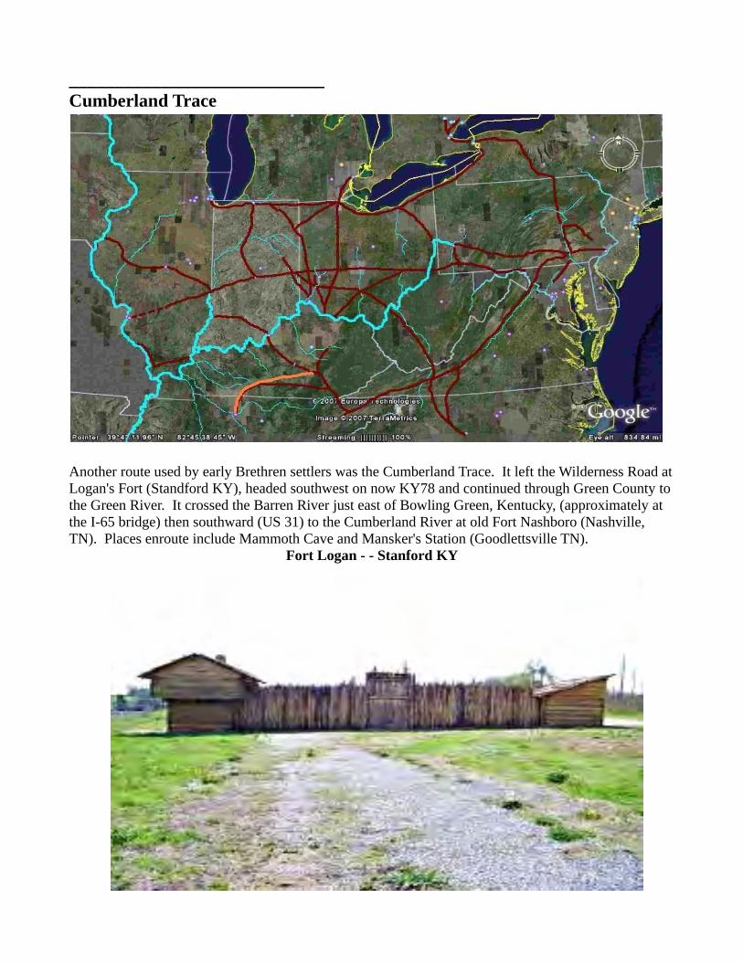
Another route used by early Brethren settlers was the Cumberland Trace. It left the Wilderness Road atLogan's Fort (Standford KY), headed southwest on now KY78 and continued through Green County to the Green River. It crossed the Barren River just east of Bowling Green, Kentucky, (approximately at the I-65 bridge) then southward (US 31) to the Cumberland River at old Fort Nashboro (Nashville, TN). Places enroute include Mammoth Cave and Mansker's Station (Goodlettsville TN).
Fort Logan - - Stanford KY

There was an early Brethren settlement south of Bowling Green in Warren and Simpson Counties Kentucky (Drakes Creek, a church site at Gold City), and a smaller one in Davidson County, TN (southwest of Nashville). These seem to be original settlers coming from the Carolinas through the Cumberland Gap.
Green River
Country
Mammoth Cave
on the Green River
Mansker's Station
Goodlettsville TN

Cumberland River
Old Fort Nashboro - - on the Cumberland River, Nashville TN
The Hunter's Trace
Another route was the Hunter's Trace, which went westward from London KY along the headwaters of the Cumberland River, to the Green River, through Somerset and Glasgow to Bowling Green, Kentucky (KY 80), then southward (US 31) to the Cumberland at old Fort Nashboro (Nashville, TN).
A trace to Mansker's Station and Fort Nashborough came from Eastern Tennessee, but it is recorded as barely passable, traveled only with horses.

The Bullskin Road
The first State Road in Ohio, 1807, the Xenia State Road was the official recognition by the new State of Ohio of the old Shawnee Indian Road from British Fort Detroit to Bullskin Landing on the Ohio River, through the major Shawnee center, Old Chillicothe (Oldtown, at Xenia). It was long called the Old Xenia Road. Down this road had come raiding armies of British Regulars and Indian allies as they attempted to destroy the Kentucky settlements. Up this road had gone the Kentucky militia when they attacked the Indians at Springfield in retaliation. In these new lands on the Northwest frontier, the Bullskin Road was a major thoroughfare.
Bullskin Creek Valley
off the Ohio River at ChiloClermont County OH
view north

Bullskin Creek is flooded by the Ohio River for half a mile back from the River, a wide valley opening.It was the first major landing for Ohio River flatboats above Fort Washington (later Cincinnati). Here the flatboat was protected, off the river, with easy unloading facilities. This settlement in Clermont County is called Utopia. The Brethren settled on the Bullskin about 1800. (Miller, Moyer, Metzgar, Rohrer, Hoover, Houser; the old Olive Branch Church. It converted en-mass to Church of Christ in the New Light Revival of 1830's.) Being farmers, they lived mostly on the level lands above the high riverbank hills, at the head of Bullskin Creek.
The Road went north through Felicity and Bethel, now Ohio 133, and crossed the East Fork of the Little Miami at Williamsburg. It crossed Stonelick Creek at Edenton (just 2 miles from the Stonelick Church). A stone marker at the east edge of Edenton is on the old Road as it goes cross-country to Clarksburg. A line of old trees shows part of the route. From Clarksburg it followed old Ohio 380 to Xenia, going through New Burlington, now submerged below the lake at Caesar's Creek State Park. Many Brethren followed this route to the east side of Dayton.
Fort Detroit
early drawing
From Xenia north to Detroit, it is U.S. 68, the Detroit Road. It goes to Yellow Spring, where it leaves the Little Miami. Then to Springfield, where it follows the Mad River of the Great Miami to Urbana. Other cities on the Road are Bellefontaine, Kenton, Findlay, Bowling Green, Toledo. From Cygnet, north of Findlay, it becomes Ohio 25 and from Toledo to Detroit it is U.S. 24.
Old Town - north of Xenia - - birthplace of Tecumseh

This is the path of Simon Kenton, when he ran the Gauntlet at Old Town ("Old Chilicothe"), in 1778, outran Indian warriors all the way to the Ohio River, close to 95 miles.
Earliest records show another old Indian path, that connected to the Bullskin Road (Ohio 133), just north of Williamsburg (on Ohio 276). Just before Owensville it turned north on the Manila Road, through the cemetery in Goshen to OH 48 at Murdock, It crossed the Little Miami River, to Lebanon then to the Ford on the Great Miami River at Franklin Ohio, and headed north along the Great Miami River.
The earliest Brethren settlement in Ohio was in Clermont County, the Obannon Church, near Goshen (1795). These Brethren lived on or near the Indian path. The Olive Branch Church near Bullskin Landing soon followed (1800). But this was heavy clay soil, and this was the Virginia Bounty Lands, so many had to move on, north to the good farmland on the Great Miami River.
Stouder Cemetery
just east ofGoshen OHon Obannon Creek
site of early log church building
Obannon Church
Frederick Weaver (in whose home the Obannon Church first met), Gabriel Kerns, and David and Daniel Miller lived in the western part of the Obannon Church area, near the Manila Road. Just above Gabriel Kerns' farm is Linton Road, which was the OLD route before Manila road was built, going through the Goshen Cemetery, meeting the Murdoch/Lebanon Road, north of town.
The Road went north from Goshen to those families of the Obannon Church (the Millers at Murdock and Bowmans unknown) who lived in Warren County. At Murdock it went on north to Deerfield (SouthLebanon) where it crossed the Little Miami River, and to Lebanon (Ohio 48). Then an angling Indian path was followed (Ohio 123) to the ford over the Great Miami at Franklin. This put them on the west side of the River, where Elder Jacob Miller lived on Bear Creek (1800).
The exact route north, on the west side of the Great Miami, is not known. There are a couple of early references (1830's) to an old River Road on the banks of the Great Miami. Probabilities are that it followed the Soldier's Home Road along the River and then went nearly strait north on the Gettysburg Road to the Wolf Creek Road, Salem Road and Covington Road (Stillwater River). Many early Brethren followed this route to the west side of Dayton.

The John Aukerman family likely used this road to the Great Miami River Ford, then followed what became the extension of the Kanawha Trace, along the Twin Creek, into Preble County, Ohio. The JohnBowman family likely used this route for their migration from the Obannon to Montgomery County, about 1800. David Miller left about 1802, and already others of the Obannon Brethren had moved northto near Dayton OH. These families were displaced from their Hamilton County homesteads (now Clermont and Warren) when the government gave these lands to the Virginia Military District and Ohioland grants were given as “Bounty Lands” to Revolutionary Veterans in lieu of their pay. Local settlers, like the Bowman and Miller families, could not keep their homesteads and had to move. The present church families moved here from Maryland and Pennsylvania, as they purchased "Bounty Lands" from the Veterans who had no wish to move west, and sold the Bounty, for what money it could bring.
Most of the earliest Brethren settlers to Ohio seem to have stopped among the Brethren already at Obannon / Stonelick, before they found lands north (the Land Office was in Cincinnati, a days walk away), then followed one or the other of the Indian Roads north. Many Brethren moved up the BullskinTrace to the east side of Dayton, to Green and Clark Counties, Ohio, to the old Beaver Creek and Donnels Creek Church areas. Other Brethren crossed the ford on the Great Miami, and settled in the fertile lands west of the River, the Lower Miami Church, the Bear Creek Church, the Stillwater Church.

____________________________Originally the River
Much of the original migration of the Brethren settlers moving west was on the Ohio River. The Brethren from Eastern Pennsylvania, Maryland, and Northern Virginia started on the old Braddock's Army Road from Cumberland Maryland, or Forbe's Road from Bedford County, Pennsylvania, going to the Forks of the Ohio at Pittsburgh. Many went to Elder George Wolfe at Redstone, on the Monongahela River, where he built flatboats, good flatboats, that would take them safely down the river. The Redstone Settlement is now Brownsburg, just up the road from old Fort Necessity where our first President, George Washington, had saved soldiers and Brethren teamsters after General Braddock was killed.
From Southern Virginia and the Yadkin in North Carolina, most of the Brethren followed the Kanawha Trace, the old Shawnee Indian War Path, down the New River to below the Falls of the Kanawha River where the Gauley River entered and the New / Kanawha became a safe river to travel. There they built

their flatboats and floated down the Kanawha, down the Ohio to the new lands west. What is a flatboat? It is whatever they could put together. Some were big and strong and might even carry several families. Some barely held together, or were small. Even if it was his best it might not prove adequate for the trip ahead. It was a flat bottom boat, mostly rectangular in shape, with high sidesand possibly a flat roofed cabin toward the back. A sweep formed the rudder to the rear and one of the men traveled on the roof and used the sweep to guide the flatboat as it traveled down the rivers. The flatboat carried the horses and wagons, all the family's goods, as it traveled to the new lands to the west.
Maybe it was easier to travel down the river than to go on land, but it was not safe. There were dead-heads: fallen trees, tops gone, hung up in the river totally underwater, with the root clump dug into the river bottom. The end pointing upstream would sometimes be raised by the current, till it would breach the surface and punch a hole in the coming flatboat. In low water there were rocks and even rapids in the river which had to be navigated correctly. There were the falls at Louisville, where the river drops 24 feet in 4 miles, most settlers stopped there. Many stopped at Maysville on the Kentucky shore, some stopped at Cincinnati in Ohio Territory. Some hardy travelers ran the Falls in their flatboats, and continued downstream to the Cumberland and Tennessee Rivers, some went on to Illinoisand Missouri. And always there were the Indians.
The migration of the white man was invasion of Indian country. White man drove off the game animals. He destroyed the forest. He destroyed the Indian customs and life. He claimed a small section of the land, of the forest, for himself. He killed the trees and opened it to bare land. The Indian knew that the land belonged to all people and was shared. No man had the right to destroy it. So from the start, each struggled to protect his own way of life. The flatboat had to tie up to the shore at night, it was too dangerous to travel in the dark, and the family liked to stretch their legs after the tiring day. A cooked meal tasted good, and fresh meat added to family provisions. The Indian was watching the passing flatboat, they could attack it where it stopped. A captive might be used to lure the boat close forattack and capture. An arrow might fall from the forest cover to stick in the wood or even injure or kill man or animal. Sometimes there would be a sneak attack with warriors suddenly coming over the sides of the boat, especially if it were too near the shore. There was Three Islands (Manchester, Ohio), where the river narrowed as it passed between the islands, the Indians often caught the men working the sweeps too hard, intent on the passage between the islands, to watch for attacking Indians. These were hazards of the trip, known, faced and normally avoided or overcome. Some died, many arrived at Limestone, and Bullskin Landing, at Cincinnati and the Falls. Some just disappeared.

Maysville KY
original village:
Limestoneis on top of the heights here
end goal of the Zane Trace
view south - across the Ohio River
Many migrated west, and were never heard from again. Were they killed by Indians, going down the River? - or coming west on the Wilderness Road? Or did they just never get word back to their folk in the east?
Brethren settlements were made where good lands were found. There were no good farmlands above the hills on the Ohio, not till you came to the Great Sandy River in Kentucky. Just below that was Limestone (now Maysville, Kentucky), where the trace went south to Blue Lick Springs and the Brethren Settlements on the Kentucky River, and Zane's Trace came down from up at Fort Henry (Wheeling). The lands were rough, not suitable for farming on the Ohio side, even across from Limestone, good land could only be found far up Zane's Trace, up near John Countryman's settlement, on the Brush Creek, near Sinking Spring. At Bullskin Landing, Bullskin Creek was a sunken creek up into the hills along the River. The Indians used it, to store their canoes, for crossing to the Kaintuck shore. It was used so frequently, that a major Indian Road went from the Bullskin to Old Chillicothe (near Xenia, Ohio) and on from there clear to the British Fort Detroit. This became a common goal for the Brethren migrant, since here, for the first time, was found good farmland within reasonable distancefrom the river, and Brethren congregations were soon found here.
Fort Washington
now Cincinnati
Cincinnati was between the Little Miami River and the Great Miami River, both coming from far inland in Ohio Territory. Early settlements grew up on both rivers, and the Brethren quickly came. Across the river was the mouth of the Licking River which went down into settled areas of Kaintuck. Brethren were found there, a couple Baptist churches may have originated as Brethren. Downstream from Cincinnati, the Kentucky River comes in from the south near Madison, Indiana. The Brethren hadsettled upstream on it, where there was good farmland. Soon, Brethren were across the river in Clark's Grant (now: Olive Branch Cemetery), the first Brethren Church in Indiana Territory.
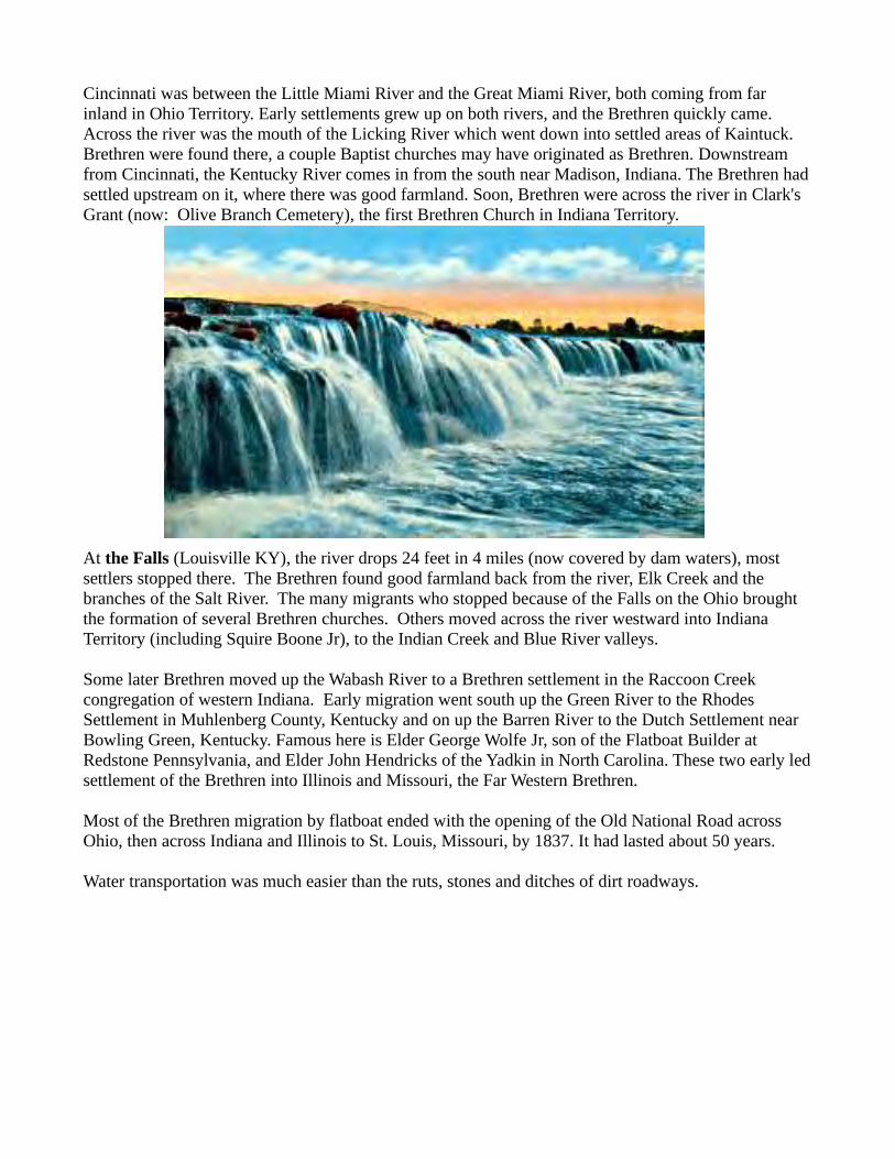
At the Falls (Louisville KY), the river drops 24 feet in 4 miles (now covered by dam waters), most settlers stopped there. The Brethren found good farmland back from the river, Elk Creek and the branches of the Salt River. The many migrants who stopped because of the Falls on the Ohio brought the formation of several Brethren churches. Others moved across the river westward into Indiana Territory (including Squire Boone Jr), to the Indian Creek and Blue River valleys.
Some later Brethren moved up the Wabash River to a Brethren settlement in the Raccoon Creek congregation of western Indiana. Early migration went south up the Green River to the Rhodes Settlement in Muhlenberg County, Kentucky and on up the Barren River to the Dutch Settlement near Bowling Green, Kentucky. Famous here is Elder George Wolfe Jr, son of the Flatboat Builder at Redstone Pennsylvania, and Elder John Hendricks of the Yadkin in North Carolina. These two early ledsettlement of the Brethren into Illinois and Missouri, the Far Western Brethren.
Most of the Brethren migration by flatboat ended with the opening of the Old National Road across Ohio, then across Indiana and Illinois to St. Louis, Missouri, by 1837. It had lasted about 50 years.
Water transportation was much easier than the ruts, stones and ditches of dirt roadways.

The Canada Road
The early Brethren moved north on the Susquehanna River into Northumberland County, Pennsylvania even before the Revolutionary War. There was a trace north along the River, there were also a couple traces from the Tulpehocken and from Reading across Pine Ridge into the Shamokin Valley.
Shamokin Valley
north of Readingand the Pine Ridge
In 1800, the King opened up settlement in Upper Canada (now Ontario). The land was available cheap, in "Lots" of 200 acres, by Concessions of 35 lots, in each of a number of townships and counties. There

was considerable Mennonite, Brethren and River Brethren migration to Lincoln County (between Lake Erie and Lake Ontario -next to the Niagara Falls); Vaughan township, York County (north-west of Toronto); and near Kitchener. Many Brethren from Brother's Valley (Somerset County), Northumberland County (Shamokin, West Branch and Lycoming Valleys) and Southern Pennsylvania areas went up. In the east, there are known two mainly parallel roads, used for migration and travel to Canada.
a notebook by Joseph Bowman of Waterloo Ontariovi
-------------------------------Description of the road from Reading to Waterloo Township,Hamilton County, Upper Canada. Joseph Bowman, started Septemberthe 4th, 1817, and arrived in Waterloo, October the 2nd 1817.
From Reading to: miles (located)Kergerstown ..................... 10 (?near Hamburg PA)Orwigsburg ...................... 11 (east of Pottsville)Sunbury ........................... 47Northumberland ............... 2Milltown ......................... 12 (Milton PA)Bensborough .................. 14 (?Muncy PA)Muncy Creek ................... 2Williamsport ................... 12Heur's tavern ................... 17 (?Roaring Branch PA)Blockhouse ..................... 14 (?Covington PA)Peters Camp ................... 12 (?Tioga PA)Widow Berry ................. 18 (?Presho NY)Addam Hart .................... 6 (?Gang Mills NY)Thomas Mayberry .......... 20 (Bath NY)Robert Patterson .............. 6 (?Avoca NY)Mulhollans tavern .......... 20 (Danville NY)Dreisbachs tavern ........... 3 (Sparta NY)Bigtree ........................... 15 (Geneseo NY)Genasee River ................ 7 (Avon NY)Calladony Town. ............ 7 (Caladonia NY)Davis' tavern .................. 4Leroyl ............................ 3 (Le Roy NY)Battavia ......................... 11 (Batavia NYRichardson's tavern ....... 11 (?Pembroke NY)Hersy's tavern ................ 15 (Harris Hill NY)Buffalo ........................... 14Blackrock ferry ............... 2John Boyer ..................... 10 (?Black Creek ONT)Falls ................................. 8Jacob Myer ..................... 20 (Jordan ONT)Carpenter's tavern ........... 13 (?Stoney Creek ONT)Dundass .......................... 18 (edge of Hamilton)John Erb's Mill ................ 23 (Preston ONT) --------- Miles ..................... 429

Sunbury PAFort Augusta
on the Susquehanna River
This was a western road went from Reading to Sunbury (Pennsylvania 61), followed the West Branch of the Susquehanna River (Pennsylvania 405/I took I-180), then up the Lycoming Creek from Williamsport to Roaring Branch (U.S. 15/PA 14), and across the mountains to Blossburg (mountain road to Ogdensburg), to Tioga, to Corning, New York (U.S. 15). This road was used as early as 1798.
In New York, the west route followed the wide valley of the Chemung River, going northwest (NY 17/I-390) to Danville where they turned north (NY 63) to "Big Tree" or Geneseo, New York (Big Tree “Ken-de-wa” was chief of the Indian Village there, hence the original name).
Gennesee River Falls
From Geneseo, New York it followed the Gennesee River (NY 39) to Avon, where it crossed on the

Iroquois Trail, going to Caladonia (NY 5), to Batavia, to Buffalo, NY. There they ferried the Niagara River above the Falls. Black Rock was very close to the present Peace Bridge from Buffalo, New York to Fort Erie, Ontario. "Hersy's tavern" is Harris Tavern, the oldest building in Erie County, at Harris Hill on, New York 5, just at the edge of modern Buffalo.
West of there, above the Escarpment (the cause of the Falls) was a settlement of the Brethren and RiverBrethren. For those going on, the road went along the River to the Niagara Falls.
Niagara Escarpment
Just above the Falls, at the Chippawa River (Battle, 1812), the British Portage, Portage Road, turned inland (now Main Street, Niagara Falls, Ontario) going to Queenston, on the Niagara River below the Escarpment. At Ferry Street, a road, Lundy's Lane, turned west (Bloody Battle in the War of 1812). Later a branch of the road, called Beaver Dam Road, goes to the old Settlers Road, joining it somewhere near Jordan, Ontario, (well, it doesn't go clear through any more -the Welland Canal stops itnear Thorold, just south of St. Catherines).
Queens Highway 81
The Settler's Road went west along the base of the Escarpment. It is Highway 81 from Queenston and St. Catherines through Jordan ("20 Mile"), Vineland, Beamsville, to Grimsby ("40 Mile"). From there it

becomes Highway 8 to Stoney Creek and is Queenston Street through Hamilton. Elder Jacob Moyer (Mennonite) lived on the 20 Mile Creek, between Jordan and Vineland. There may have been a Brethren settlement at Grimsby, but I didn't find their museum open, to research.
20 Mile Creek
so named20 miles north ofNiagara River mouthinto Lake Ontario
Jordan, inland town, Museum
Those going to Kitchener followed Highway 8 directly from Hamilton, through Dundas, Cambridge, Preston, Kitchner to Waterloo. For those going to Vaughan, they followed the lake shore to beyond Mississauga and headed north on the Royal York Road and Jane Street. Maple, Vaughan twp was mentioned as 20 miles from the docks at Toronto, which is a considerable distance by horse.
Erb's Mill
Waterloo ONT
------------------Joseph Bowman started from Waterloo, February the 9th, 1819,and arrived in Reading, February the 27th 1819.

From John Erb's Mill toJacob Myer .....,,,,,,,,,,............... 60 (Jordan ONT)Cadareenstown (St Cathrines) ... 8 (St Catherines ONT)Queenstown ............................. 12 (Queenston ONT)Morehous's tavern .................... 25 (Hartland NY)Olarged Creek .......................... 13 (Oak Orchard Creek)`Tillanson's tavern ..................... 28 (?Parma's Corners NY)Rochester ................................. 11Pitsford ..................................... 8Cannandaigua .......................... 21Benyang (Penn Yang) ....,......... 22 (Penn Yan NY)Head of Sennaka Lake ............ 30 (Watkins Glen NY)Coryell's tavern ........................ 7 (?Montour Falls NY)New Town ............................... 15 (Elmira NY)Lowman's tavern ...................... 7 (Lowman NY)Tioga point .............................. 14 (Greens Landing PA)Shaw's tavern ........................... 6 (?Ulster PA)Brown's tavern ........................ 27 (Browntown -Wyalusing)Smith's Ferry .......................... 30 (?Eatonville PA)Wilksberry .............................. 20 (Wilkes-Barre PA)Rack's tavern .......................... 17Mirwein's tavern .................... 16Dreisbach's Mill ...................... 6Lehigh Water Gap .................. 12 (?Palmerton PA)Richard's Tavern ..................... 8Kutstown ................................ 6 (Kutztown PA)Reading ................................. 17 --------- Miles .......................... 458
Spending Money ........... $22.53
-------------------------------------------Lets go south from Waterloo/Kitchner Ontario ---Highway 8
Joseph Bowman went clear through on the old Settlers road (Highway 8/ Highway 81) to Elder Jacob Moyer at Jordan, and continued on to St. Catherines, Ontario. Here Highway 81 continues on to Queenston, Ontario, as Queenston Street, then York Road on to Queenston. At Queenston it comes to the bluff at the Niagara River, just at the foot of the Escarpment where the U.S. Army was defeated by British General Brock, in the War of 1812. Just south on Front Street (at Dunfries Street) was a twistinglane down to the "Sand Beach" landing on the River. Here was the ferry to Lewistown in New York. The South Landing Inn on Front Street was built near that time. From Lewistown, New York, the Settlers Road followed the Ridge Road to Rochester, New York. This was a sandy ridge several miles back from Lake Ontario, said to be the Archaic Beach of the Prehistoric "Lake Iroquois". The ferry landing was at Center Street, which is the end of the Ridge Roadat the Niagara River. The old Ridge Road is NY 104 from Lewistown going east. Samuel Morehouse built a "hotel" at Hartland Corners in 1813. This is now the west part of the town of Hartland, in Niagara County, New York.

Queenston Landing
Queenstonon the Niagara River
(yes, I drove down to the Niagara River there!)
Local Historians seemed to think that German speaking Joseph Bowman misunderstood the English name of "Oak Orchard Creek", because it was named for an Orchard of Oak trees at its mouth (Point Breeze) on the bay on Lake Ontario. The Ridge Road crosses Oak Orchard Creek at "Oak Orchard on the Ridge", just northeast of Medina, New York. I was unable to locate any records to "Tillianson's Tavern" but distances on NY 104 placed it just about NY 259, or Parma's Crossing.
Old Picture
Ridge RoadtoOak Orchard Creek
From Rochester, New York, the route would likely have followed, NY 64 to Pittsford and angled down to the Iroquois Castle of Canandaigua on the mouth of Lake Canandaigua (Finger Lakes area). From there, NY 147 goes south and east to Penn Yan (for early settlers from Pennsylvania and Yankee Connecticut) (mouth of Keuka Lake), then 14A and 14 to Watkins Glen at the head of Seneca Lake. Coryell's tavern was likely at the "Montour Falls" on the river feeding into the Lake. They then followed over the Indian Trail to the headwaters of the Susquehanna River at Horseheads (where General Sullivan had to kill his horse pack team, as he led the army in its raid against the Iroquois Indians in 1762).

Seneca Lake
one of theFinger Lakesof New York
Elmira, New York, was originally named Newtown, the name being changed in 1828. The Indian Trail followed down the Susquehanna River as far as Wilkes Barre. Tioga Point is a historical site at Greens Landing, just south of Athens, Pennsylvania. From Wilkes Barre, Joseph crossed over to the Lehigh River, passing through the Narrows the gap in the Mountain there (Lehigh Gorge), and on toward Allentown, Pennsylvania. Instead, he turned west to Kutztown and on to Reading.
Lehigh Gorge
This is a main Iroquois Indian Trail that followed this route, from Canada all the way down to the Susquehanna River Valley (noted by an earliest settler, Jemima Wilkinson).

The Wayne Trace
In 1793, General "Mad" Anthony Wayne, of Revolutionary War fame, replaced Governor St. Clair, whohad been so devastatingly defeated at Fort Recovery, Ohio. He came to Fort Washington (now Cincinnati, Ohio) and brought with him something that Governor St. Clair did not have - a contingent of the Continental Line, 1500 soldiers strong. He supplemented these with Kentucky militia, having a total well over 2500. These were stationed on the Great Miami River, just north of Cincinnatus, at Fort Hamilton. He crossed the River with his army, and moved northward, upstream. He first crossed a riverat four miles from Fort Hamilton, which he named the: "Four Mile" (stream followed by the Delaware Indian Road, and stream on which the Four Mile Church was formed in Indiana). He continued upstream and at 7 miles forded another river, which again he logically named, the: "Seven Mile" (this stream goes north to Eaton Ohio, the site of old Fort St. Clair, of the previous Governor). He marched up the east side of the Seven Mile, above the banks on the hills alongside. His trace is about one mile east and parallel to US 127. He passed the old Fort St. Clair and went on toward St. Clair's fort at Fort Jefferson. He passed through the town of Castine and his men camped about 2 miles south of Fort Jefferson, at Wayne Lakes on OH 121. He moved on north of Fort Jefferson to a heights along the Greenville Creek and built a large fort for over winter, Fort

Fort Greene Ville
Greenville. The fort stood about 2 blocks wide and about 4 blocks long, angling NE-SW along Greenville Creek. This places the nearest corner of the fort about 6 blocks from the Greenville Brethren's Home. During the winter, he had his soldiers build a fortification at the site of St. Clairs defeat, naming it Fort Recovery, 25 miles north of Greenville.
Fort Recovery
In 1794, he began his push north. The Indians met him at the old battlefield where the new Fort Recovery was. This time they were defeated. With the stability of the professional Continental Line, General Wayne then began a very defensive forward advance - the Indians probed his lines and formation repeatedly, but could gain no advantage and could not stop him. He pushed them beyond their own villages and fields and destroyed all their supplies and substance.
Finally, on the Maumee River in northern Ohio, as he approached the established outpost British Fortifications, the Indians set up a major defense in the debris of a Tornado, the Battle of Fallen Timbers. Facing a bayonet charge by the Continenals, with the militia finding a way to their rear, the Indians fled. The Indian opposition to settlement in Ohio was ended at the Treaty of Greenville, 1795. A line was drawn across the state from Fort Recovery, and another line drawn from there, angling southwest to the Ohio, to the mouth of the Kentucky River (when the Ohio State Line was laid in 1803,

this additional area west of the Ohio Line was called "the Gore"). General Wayne named all the lands north and west of the Great Miami River (to Lake St. Mary's at Celina, Ohio) as Indian Territory - called "Indiana", from which, the state gained its name.
Treaty of Greenville
traditional picture
The area south and east of these lines was shared land, the Indians were free to use it, and the settlers could freely establish homes. (In a second treaty at Greenville, in 1814, the Brethren Minister, Philip Younce and his family played a major supporting role. Margaret Byrket Younce baked bread and offered food to the some 4000 Indians gathered there.)
The Wayne Trace from Greenville north is followed by OH 49 to Fort Recovery and north along the state line. At Willshire it jogs east across the St. Mary's River and continues north. At US 224, the old trace continued north through Payne to the Maumee River, but OH 49 goes east and north to Convoy before coming back to Payne.
French FortNiles MI
First SettlerSquireThompson
(Toney Family Four Mile)
"raised corn sold whiskey to Indians"

The early Brethren followed this route north from the settlements on the Great Miami (Montgomery, Miami, Darke, Preble Counties, Ohio) and the Four Mile. Earliest settlers were Jacob Witter and SquireThompson who moved to the St Joseph River in Michigan Territory about 1824. They followed the Wayne Trace to the crossing of the St. Mary's River, then followed an Indian Trail going to the north-west. The Indian Trail went to the old French Fort at the juncture of the St. Mary's and St. Joseph Rivers which form the Maumee (Fort Wayne, Indiana) The Indian Trail continues northwest into the Lake area of Northern Indiana and follows the Elkhart River through Lagrange and Goshen, Indiana, tothe St Joseph River (another one - named by the French Priest Champaign) at Elkhart, Indiana. It then follows the St. Joseph River west to its "South Bend" (Indiana) where it heads north past the French fort at Niles, Michigan, to Lake Michigan at St. Joe-Benton Harbor, Michigan. Goshen, Indiana, was named by the early Brethren for their early home on the Obannon, at Goshen in Clermont County, Ohio, (Obannon Church). The Indian Trail, starting near Columbus, Ohio, is followed by US 33.
The Brethren settlements in northern Ohio, Indiana, and Illinois received other Brethren coming directly west from the Beaver River, off the Ohio just outside Pittsburgh. Other northern Pennsylvania Brethren used the old Shamokin Trail, which followed the West Branch of the Susquehanna River (to St. Marys / Dubois), possibly going through Warren to Erie Pennsylvania. These routes of migration have not been ascertained by me yet -- but in Ohio, those farther south basically are followed by US 30 in the middle of the state. Farther north the migration route from the Beaver is along OH 14 to the Lakeshore and follows US 6 and US 20 west.
Some Canada Brethren used the lake shore roads, coming down from Niagara through Cleveland. Others crossed Ontario to Detroit, then followed the old Indian Trail that ran from Fort Detroit to Fort Dearborn (Chicago), now US 12. Still others went to Georgian Bay, and came by water, down Lake Michigan to the Wisconsin and Illinois shores.
Waynes FortSt Mary's River
1816Fort Wayne IN

The Kanawha Way
Mr. Argus Ogborn was a Quaker historian in Richmond, Indiana. He let me make a copy of his copy of the Kanawha Way Bill of the Road, which he had found in a collection (unspecified) some years ago. He saw it for what it was, the mile by mile progress a Quaker settler would walk with team and wagon to travel from North Carolina to Richmond, but I recognized many of the named places in the Way Bill from travel, residency and research in these regions. From this I drew up and gave him a map tracing the path of the Trace. In researching families on this trace for my book on the Four Mile Church, I recognized that the Brethren used this as a major path from Virginia to Ohio. I had frequently asked myself a question about the route of the Dunkers (nickname for the Brethren) in Virginia to Ohio and the West, since I had early found that most of them did not use Daniel Boone's Wilderness Road. (The Flat Creek Mission, Church of the Brethren, is right on the Old Warriors Path - Goose Creek, mouth of Mudlick, near Manchester, Kentucky, my parents lived there at the mission, Mudlick Station, head of Mudlick. I occasionally visited there, and I followed the path and story of Daniel Boone and the early Dunkers in the Kaintuck lands.) Only a few of the Carolina Brethren who followed the Wilderness Road into Kentucky, came up into Ohio. I've followed Forbes' Road and Braddock's Road in Pennsylvania, when I pastored at Beaver Dam (Maryland) and with my brother, who still pastors in Western Pennsylvania. Maryland and Pennsylvania Brethren, including some in the upper part of the Valley, would have used those routes and come down the Ohio on flatboats. But many early Dunkers lived much farther south in the Valley, and there was a major early settlement of the Brethren below Roanoke, on the front of the Blue Ridge in Franklin and Floyd Counties, the old Carolina Road, (Elder Jacob Miller families and neighbors) who came from there to western Ohio and Indiana Territory. The Kanawha Trace was their route. Virginia Dunker Family names are found along it.
The Kanawha Way Bill of the Road, or Waybill, begins in the north central part of North Carolinawhere the Moravian Brethren, Friends (or Quakers) and German Baptist Brethren (Dunkers, Church of the Brethren) had major settlements. Early Dunker Churches were along the Yadkin River starting in Wilkes County, going east to Winston Salem, then south through Salisbury.
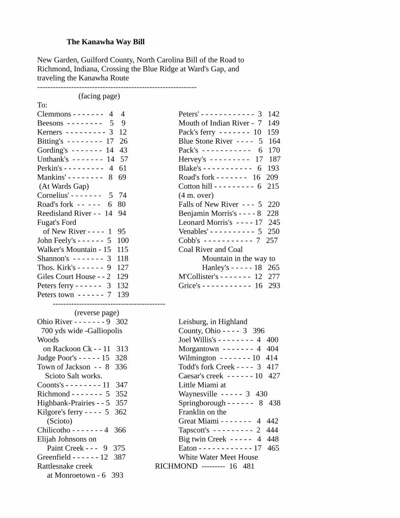
The Kanawha Way Bill
New Garden, Guilford County, North Carolina Bill of the Road to Richmond, Indiana, Crossing the Blue Ridge at Ward's Gap, andtraveling the Kanawha Route------------------------------------------------------------- (facing page) To: Clemmons - - - - - - - 4 4 Peters' - - - - - - - - - - - - 3 142Beesons - - - - - - - - 5 9 Mouth of Indian River - 7 149Kerners - - - - - - - - - 3 12 Pack's ferry - - - - - - - 10 159Bitting's - - - - - - - - 17 26 Blue Stone River - - - - 5 164Gording's - - - - - - - 14 43 Pack's - - - - - - - - - - - 6 170Unthank's - - - - - - - 14 57 Hervey's - - - - - - - - - 17 187Perkin's - - - - - - - - - 4 61 Blake's - - - - - - - - - - - 6 193Mankins' - - - - - - - - 8 69 Road's fork - - - - - - - 16 209 (At Wards Gap) Cotton hill - - - - - - - - - 6 215Cornelius' - - - - - - - 5 74 (4 m. over)Road's fork - - - - - 6 80 Falls of New River - - - 5 220Reedisland River - - 14 94 Benjamin Morris's - - - - 8 228Fugat's Ford Leonard Morris's - - - - 17 245 of New River - - - - 1 95 Venables' - - - - - - - - - - 5 250John Feely's - - - - - - 5 100 Cobb's - - - - - - - - - - - 7 257Walker's Mountain - 15 115 Coal River and CoalShannon's - - - - - - - 3 118 Mountain in the way toThos. Kirk's - - - - - - 9 127 Hanley's - - - - - 18 265Giles Court House - - 2 129 M'Collister's - - - - - - - 12 277Peters ferry - - - - - - 3 132 Grice's - - - - - - - - - - - 16 293Peters town - - - - - - 7 139 ------------------------------------------- (reverse page)Ohio River - - - - - - - 9 302 Leisburg, in Highland 700 yds wide -Galliopolis County, Ohio - - - - 3 396Woods Joel Willis's - - - - - - - - 4 400 on Rackoon Ck - - 11 313 Morgantown - - - - - - - 4 404Judge Poor's - - - - - 15 328 Wilmington - - - - - - - 10 414Town of Jackson - - 8 336 Todd's fork Creek - - - - 3 417 Scioto Salt works. Caesar's creek - - - - - - 10 427Coonts's - - - - - - - - 11 347 Little Miami atRichmond - - - - - - - 5 352 Waynesville - - - - - 3 430Highbank-Prairies - - 5 357 Springborough - - - - - - 8 438Kilgore's ferry - - - - 5 362 Franklin on the (Scioto) Great Miami - - - - - - - 4 442Chilicotho - - - - - - - 4 366 Tapscott's - - - - - - - - - 2 444Elijah Johnsons on Big twin Creek - - - - - 4 448 Paint Creek - - - 9 375 Eaton - - - - - - - - - - - - 17 465Greenfield - - - - - - 12 387 White Water Meet HouseRattlesnake creek RICHMOND --------- 16 481 at Monroetown - 6 393

- "This Bill may not be precisely correct in every instance" --------------------------------------------------------------(foolscap paper - before 1820) obtained from Argus OgbornQuaker Historian, Richmond, Indiana. New Garden was in Greensboro,North Carolina - Whitewater Meeting was begun 1809) Assistance on this study was given by several people living in communities along the route of the trace.Especial thanks is to be given to Rev. Robert Roller, pastor of the Fraternity Church of the Brethren, Winston Salem, North Carolina; Stan Bumgardner, Historian, West Virginia Division of Culture and History, Charleston, West Virginia; and Harriet Foley, Franklin, Ohio. Parts of the route through Virginia and West Virginia were determined from known locations, using U.S. Topographical Maps.
New GardenFriends Meetinghouse
near Greensboro NC
(old picture)
The Waybill that we have, begins at New Garden Friends Church, New Garden on the west side of Greensboro, at Guilliford College. Clemmons was likely at Friendship, near the airport. By distance, Beesons could be the town of Colfax; and Kernersville, east of Winston Salem, is Kerners. Continuing on NC 66 to old US 52, Bittings would likely be at Rural Hall, Gordings would be at Pilot Mountain, and Unthanks at Mount Airy. The route followed, Perkins would be at Salem, edge of modern Mt Airy, It then went due north to Ward's Gap, east of US 52 on the Blue Ridge Parkway. Pine Creek, from Ward’s Gap, goes north to Reed Island Creek, north of Gladesboro VA near Crooked Oak or Red Hill.
Wards GapBlue Ridge Mountains
north of Mount Airy NC
(view looks north)(Blue Ridge Mts - almost E-W here)

New River
flowing north
starting south in North Carolina, flowing north intoVirginia
thence, westthrough West Virginiato theOhio Riverat Gallipolis
There seem to be no recognized roads except VA100, going north from near modern Hillsville, on top of the ridge. The trace is likely followed by VA100 down Little Reed Island Creek through Popular Camp Mountain. It crosses Reed Island River at Patterson and then the New River (Fugat's Ferry, now a bridge). VA100 does not cross Draper's Mountain to Pulaski, and John Feeley's would be at McAdam or possibly Draper. Crossing Walker Mountain, VA100 comes to Poplar Hill, which would be Shannon's and comes back to the New River, which has taken a big loop, at Pearisburg, old Giles CourtHouse, and US 460. Peter's Ferry could be located at Narrows, where they could recross the New River. (It must be remembered that in these early days, the lack of most bridges meant that obstacles that we now ignore, drastically affected travel patterns. A Traveler sometimes went longer, or worse, routes, because there was no way they could cross a River. This is true of the routes here, and across West Virginia.)
Remember, also, that in those days Virginia went to the Ohio River. Across now West Virginia, the Kanawha Way, by tradition, followed the Shawnee Indian War Path close to the New or Kanawha River. Peterstown is just in West Virginia at US 219 and WV 12. Christian Peter's home would have been out of Peterstown on WV 12. There Bozoo Road goes left and down into the old river bottom, a shorter route than WV 12. Bluestone Lake floods this area, but the Indian River enters the New River below Indian Mills, coming down the valley from the Northeast. The Blue Stone River comes up the valley from the Southwest about 15 miles down stream and Pack's ferry would have been out in the lake, between them (before Wolf Creek Mountain). Unless there was a bottom land route (now flooded), the mountains push in close to the New River and the trace would have followed a trail up to Pipe Stem, and followed the Pipestem Creek down to the Blue Stone River crossing. Following up another trail out of the Blue Stone, Pack's could possibly be at Nimitz and Jumping Branch, where another old road (WV 3) goes to Shady Spring. There modern US 19 shows sections of an old road near it. US 19 goes to Beckley, Mount Hope and Glen Jean (with Harvey just beyond) and on to Fayetteville on the downriver side of the New River Gorge. This is possibly "Road's Fork", where the trace did not try to recross the New River, but took WV 16, to Beckwith where it took the very rugged Falls Creek Road over Cotton Hill. The creek and trail come out at the Falls of the New River, now Kanawha Falls (where the Kanawha River Dam now is). The Gauley River enters the New River at Gauley Bridge above the Dam, and the River changed, it is larger, and has a more constant flow. The valley widens. It is now called the Kanawha. Here below the falls, early settlers built flat boats and floated down the River to Point Pleasant, then down the Ohio to Kaintuck or Cincinnati.

New River Gorge
northeast of Beckley WVa
cut through Appelachian Mts
view is almost due northdownstream
The trace followed a country road along the south bank of the Kanawha River. It is pressed closely by high rugged mountains, the only level areas are where mountain streams enter the river. A couple of these have become towns, Deep Water, Eagle. Benjamin Morris probably lived where Montgomery is, where WV 61 comes down off the mountain. There is a better roadway, and towns of Crown Hill and Cabin Creek. At Chelyan the West Virginia Turnpike and US 119 come down to the River. Leonard Morris had a fortified log house ("fort") at Marmet, on the south side of the River just above Charleston, where the Toney's and others fled during the Indian raids of 1794. Venables would have been in the eastern area of South Charleston called Kanawha City, where there used to be a second branch of the Kanawha River by that name. Cobb's would also be in South Charleston near Vandalia. The Coal River enters the Kanawha at St. Albans, where US 35 comes in from downstream and Ohio. There is quite a ridge, actually a mountain, between the two nearly parallel rivers for many miles. Hanley's, M'Collister's and Grice's would have been stops on the lower river before crossing to Gallipolis Ohio. The trace followed the bank of the Kanawha River clear to the Ohio, then down the bank of the Ohio to across from Gallipolis, because of high ridges along both rivers. At Gallipolis, they would have rafted over the Ohio, landing at the old town dock area, today's City Park.
Kanawha River
New River has becomequite large

An alternate route, known to be used by the Indians and some settlers, followed Moss Creek out of Beckley, one of the headwaters of the Coal River. It then followed the north bank of the Coal River through Blooming Rose to St. Albans, where Coal River empties into the Kanawha; part of this is now WV 3.
"Old Road"
going west out of Beckleyinto Mossy Creekand Coal River
alternate route of migrationandShawnee Indian War Path
Mossy Creek - originally calledToney Creek
settlement of Toney familyon Coal River- 1785 massacre
At Gallipolis, the Kanawha Way followed Gen. Lewis' Army Road to Chillicothe (after the Battle of Point Pleasant, 1774, he pushed the Indians back to their main city, building a road for his cannon, nowUS 35: remnants of Old 35, and likely the trace, are seen in various places through the valleys either side of the new road). The Army Road, and the trace, started in downtown Gallipolis. Old 35 goes out of Gallipolis north of the old city and goes along Chicamauga Creek inland almost to Mills before it crosses the creek. This probably was the original route.
Gallipolis Ohio
1790 French Refugee Settlement
Ohio Riverjust below mouthof Kanawha River
Kanawha Way crossed hereonly 15 years later

(The creek enters the Ohio River south of Gallipolis, but swings north behind most of the city before it turns inland. It is quite swampy. Chillicothe Road, a street in the south part of Gallipolis crosses the swamps with a bridge and goes west till it junctions with OH 588 going on to Rodney. OH 588 starts inGallipolis at the city park and bridges the top end of the swamp.) At Rodney, the Jackson Road is Old 35. Crossing Raccoon Creek at Adamsville, Woods was certainly Wood's Mill. The trace then went on to Rio Grande, where the Adamsville Road is north of US 35, actually the back drive on Bob Evans' farm. Judge Poor's (or Squire Poor) was at Winchester, south of 35 at OH 327. This is the original Old 35, or Gallipolis Pike, now called Dixon Run Road. Jackson is still a major Ohio town, the town and trace are both south of modern US 35. Richmond is now called Richmond Dale, and is on a stretch of the old road north of modern US 35. Kilgore's Ferry over the Scioto River is at the bridge on US 35/50,north of the mouth of Paint Creek. The trace angled into Chillicothe on Eastern Ave (Jackson or Gallipolis Road). It then turned up Hickory Street to Main Street, and went west past the State Capitol. Chillicothe was the first Capitol of the State of Ohio. It had been a major Shawnee Indian center and is still noted for its Hopewell Indian mounds (Mound City). There were early settlers with Dunker family names along this stretch of the trace, but we have no record of churches.
Chillicothe Ohio
first state capitol(white building in picture)
Kanawha Way - from SEZane Trace - from NEmeet - go west together
Leaving Chillicothe, the Kanawha Way followed the Zane Trace out of town on the Limestone Road (now Western Ave; Limestone was the original name for Maysville Kentucky, the destination of the Zane Trace). They went west along Paint Creek (US 50). Elijah Johnson's would be north of Bourneville, and the trace followed an old Indian trail that went west up a wide valley. This road is called Lower Twin, and goes to South Salem. From the Covered Bridge on Lower Twin, just west of South Salem, the trace went north off the present road and kept to the highlands (going directly in front of Robt Smalley's house, which now sits far back a lane from the road) to Greenfield, where it forded Paint Creek on the rocky bottoms, just south of town (the old Fall Creek Church was farther south, westof Paint Creek on Fall Creek). From there, the trace turned westward and crossed Rattlesnake Creek at Monroetown (East Monroe, on OH 28), to Leesburg (US 62 and OH 28), and on west to Joel Willis', now Highland (here the old Lexington Church was just south of town). In Highland, the trace turned north on Wilmington or Antioch Road. This is the same old winding trace until it gets to Wilmington, where the Antioch Road met Old 73, which turned west on the trace into town. Old 73 now deadends atthe Airport, heading directly toward the control tower.

The trace went westward from Wilmington to Waynesville, along OH 73. It crossed Todd Fork Creek and at Caesar's Creek State Park went north at the "Y," going through Harveysburg, where it wound down to Caesar's Creek (now under the reservoir). The trace went to Corwin where it forded the Little Miami into Waynesville. Corwin is north of OH 73, the trace separated at the Cemetery. It went up into the north part of Waynesville, and came back out on OH 73 on the west side of town. The trace (and OH 73) continue on west to Springboro and Franklin along the present route (the Old Upper Springboro Pike to Waynesville coming into Franklin on 2nd Street). In the 1870's the ferry was replaced by a suspension bridge on 4th Street, later by the present Lion Bridge on 2nd Street.
Franklin Ohio
Great Miami Riverdirectly behind this buildings
ford of river - to your left
At Franklin, the trace forded the Great Miami River below the 6th Street Railroad Bridge, then WilliamBarkalow started a ferry at his house in 1804 (at the Trestle). The trace went back north along the river and turned west, OH 123, past Rev Tapscott's house (in front of his Primitive Baptist Church), just east of the town of Carlisle. The trace continued on from Carlisle, until it crossed Twin Creek, there it turned on Sugar Street to Sunbury and stayed south of Germantown and Big Twin Creek. At the five points, it went ahead (to the right) on the Mudlick and Sigel Road to where Henry Moyer lived, and where it met the road going west out of Germantown (OH 725).
The trace continued along 725 to Gratis. Keep right at the Y into Gratis, and OH 122 is the old winding trace angling northwest to Eaton, where St Clair's Fort still stood from the Indian Wars. From Eaton, the trace went past the Fort to the little town of Boston in Indiana. From there it seems to have gone west (on a road that went to the old county seat of Salisbury - west of Richmond).
Whitewater Meeting was founded 1809, in a log church at a cemetery that stood almostdirectly under the US 27 overpass, justbeyond the railroad tracks (200 feet west of the old brick Quaker Church at North G street). Whitewater River, Richmond - toward church site

It is known that there was an old Army Road from Fort Greenville to Fort Vincennes. At this time therewas no town of Richmond, and just the beginning of a "County Seat" on the Army Road called Salisbury. It was located just west of now Richmond. A known road went from Dayton to Eaton to Boston and John Conner's Trading Post (Connersville IN), and a branch off of it went to Salisbury. This likely was the route of the Kanawha WayBill to the Whitewater Quaker Church in Richmond. William Henry Harrison, governor of the Northwest Territory, living at Vincennes, reviewed militia at "Boston" in 1810. The actual site was west of Boston IN on this road, near the "Strait Line Pike".
Daniel DuBois traced his route from Monmouth County new Jersey to Carlisle in his diary in 1804. From Chillicothe to Franklin his route matches those of the Waybill. He averaged 40 miles per day. This is the first known use of the trace across the state.
Dunker settlement here was very early. Some of the children of Elder Jacob Miller from Franklin County Virginia, in the 1790's came up the Great Miami to Dayton, then by 1803, moved west to the state line. Philip and Anna (Miller) Lybrook followed the trace in 1806, when he returned to Virginia and brought his wife and families of married children back to Indiana (Upper Four Mile Church). They came by wagon (2 wagons loaded with furniture and supplies) with a number of other wagons, married children and their kin. From Eaton he came west to Boston and south to his home (some 5 miles).
The trace leaving Chillicothe was not in existence when the first Quaker into Ohio, Nathaniel Pope, settled Leesburg in 1802. He left Chillicothe on the old Indian Path to Old Chillicothe (now US 35 to Xenia) along the North Fork of Paint Creek. At Col. Massie's settlement, Frankfort, Pope went southwest to Leesburg. The path of the trace from Chillicothe to Leesburg was a shortened route from his settlement. The trace was not in existence in 1802, it was used clear across the state by 1806. The Waybill was after 1809. The Kanawha Way trace is very important to the settlement of Southern Ohio. The Quakers and Dunkers, and many others from Southern Virginia and North Carolina, followed it as they came to Ohio Country. It was probably the most used land route for migration into Ohio in the years before the Old National Road (c1827).

________________________________________The Shore Road
The Shore Road was an Indian route used by many migrants going west. The eastern beginning of it was less used by most Brethren, because their origins were farther south. This changed as they left Pittsburg on the Ohio River, and got to the Beaver River, just inside Pennsylvania, or just beyond as they entered Ohio.
Buffalo NY
The Niagara River
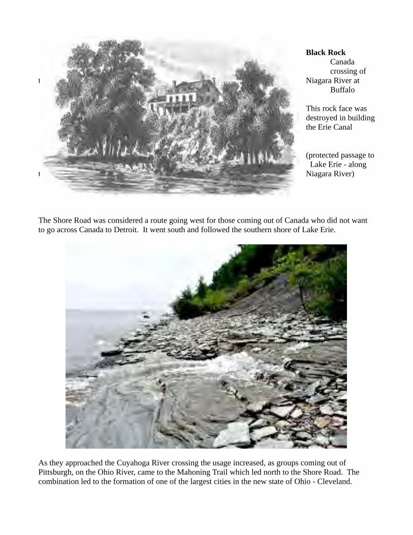
Black RockCanadacrossing of
the Niagara River atBuffalo
This rock face wasdestroyed in buildingthe Erie Canal
(protected passage to Lake Erie - along
the Niagara River)
The Shore Road was considered a route going west for those coming out of Canada who did not want to go across Canada to Detroit. It went south and followed the southern shore of Lake Erie.
As they approached the Cuyahoga River crossing the usage increased, as groups coming out of Pittsburgh, on the Ohio River, came to the Mahoning Trail which led north to the Shore Road. The combination led to the formation of one of the largest cities in the new state of Ohio - Cleveland.

Mahoning Trail
from the Mouth of theBeaver River,following theMahoning River northto the Cuyahoga River
The Mahoning Trail was a major migration route in Northeastern Ohio which led from the Ohio River at East Liverpool Ohio, at the bend of the river, and went northwest to the mouth of the Cuyohoga River, Cleveland OH. Leaving the Ohio at East Liverpool, it is followed today by US 30, then at Lisbon OH continues as OH 14 to downtown Cleveland. An alternate access from the Beaver Valley in western Pennsylvania came in from the east as OH 14 at Salem OH. There seem to be Brethren who came from both directions. While many of these settled in Northeastern Ohio, others took the Shore Road, going to Northern Indiana and Illinois..
The Shore Road continued on west, skirting Sandusky Bay and heading for the Maumee River at Toledo. I do not know the exact route.

British Fort at Maumee River (Toledo) British soldiers watched as General Wayne fought the Indians at Fallen Timbers but would not open the gates for the escaping Indians.
The Shore Road went north across the Maumee, to Fort Detroit
Toledo OH - mid 1800s - Maumee River Bridges
There is a major route between Fort Detroit and Fort Dearborn (Chicago), now US 112, in southern Michigan. This was the route taken by Chief White Pigeon, in a council at Fort Dearborn, overheard plans to attack a white settlement in southern Michigan. Knowing the people, Chief White Pigeon ran the near 150 miles, to save his friends, and died on delivering the message. He is buried there, in the little town of White Pigeon, named for him.

prairie lands
Southern MichiganNorthern Indiana
This may be the route going on west taken by the Shore Road. The route did become a stage coach road. One known "Lost Treasure" is at an unknown point along it - west nearer Lake Michigan. The Stage Coach was being chased by robbers, due to a box of "treasure" (what, is unknown). Passing through a swampish area near the St Joseph River (somewhere near Niles probably), the treasure was thrown over into the water. It sank and has never been found.
French Fortat Niles MI
The Shore Road, going on to Fort Dearborn, would of necessity go south of the Indiana Sand Dunes.

Fort Dearborn was constructed on the Chicago River in 1802. The military were withdrawn in 1812, due to the War of 1812. They were attacked in a massacre by the Pottawatami Indians only a short distance from the Fort. The wooden fort was burnt.
view of Fort Dearborn and the Chicago River
Settlement of the Village of Chicago began in the mid 1830s. The Miller brothers, Samuel and James, grandsons of Elder Jacob Miller, of the Four Mile Church, in Indiana Territory, were "first Trustees".
The Miller houses were near Wolfe Point, on the Chicago River.
Samuel Miller's wife died, and he move to Michigan City Indiana, where he set up a grain transportation business. His port was marked by the Michigan City Lighthouse, which he built.

____________________________________The Kaskaskia Road
This road was almost certainly used by George Rogers Clark and his army, as they captured the British at Fort Kaskaskia, then crossed southern Illinois to Fort Sackville, at Vincennes Indiana.
When George Wolfe Jr went to Union County Illinois about 1810, he used an Indian road, called “The Kaskaskia Road”. Fort Kaskaskia, an old French fort at the mouth of the Kaskaskia River was the capitol of the French Empire in the Mississippi Valley in central America. capital of the French on the Mississippi. George Wolfe Jr and the party with him would have crossed the Ohio River at Old Shawneetown. They followed a French and Indian trail that went due west to the Mississippi. The original trail twisted south below the Lakes area to the Big Muddy River to the Mississippi and likely George Wolfe and party followed it to their homestead in the fertile farmlands south of the Lakes area.
Old Shawnee Townon the Ohio River
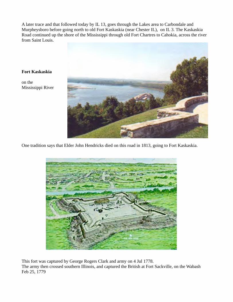
A later trace and that followed today by IL 13, goes through the Lakes area to Carbondale and Murpheysboro before going north to old Fort Kaskaskia (near Chester IL), on IL 3. The Kaskaskia Road continued up the shore of the Mississippi through old Fort Chartres to Cahokia, across the river from Saint Louis.
Fort Kaskaskia
on the Mississippi River
One tradition says that Elder John Hendricks died on this road in 1813, going to Fort Kaskaskia.
This fort was captured by George Rogers Clark and army on 4 Jul 1778.The army then crossed southern Illinois, and captured the British at Fort Sackville, on the WabashFeb 25, 1779

George Rogers Clark
the rivers are recorded as being flooded
Fort Sackville - Wabash River - Vincennes IN

_____________________________________The Louisville-Vincennes Road
Coming back from the victory at Fort Sackville, George Rogers Clark and his army followed what is called the Buffalo Trace (lower Brown route - below - - upper Red route is US150).

From near Louisville, going northwest toward Vincennes, the Buffalo Trace started at the Ohio River near Clarksville. South of Salem, in Washington Co, it crossed the Blue River, where early Brethren formed the Blue River Baptist Association. It went northwest to Floyds Knob. At Floyds Knob, the Louisville Vincennes Road came in from the south.
The early settlers crossed the Ohio River at Oatman’s Ferry. The Oatman’s Ferry left the city of Louisville well below the falls, near the end of Market Street, and landed at Ferry Street, in New Albany. From there, a road went west to Corydon (first Capitol of the State of Indiana), the Vincennes road went north, and is identified now at State Street, as Paoli Pike or Old Vincennes Road. This goes north to Floyds Knob.
From Floyds Knob, the Buffalo Trace went slightly north of west to Galena and Greenville, then turnedsharply south, before turning back west, past the Reeps Cemetery (Brethren Church –named Indian Creek Church), and into Bradford as its main east/west street. From Bradford it continued on west to Central Barren and Hancock Chapel. The Trace continued on slightly north and west to Cuzco, Crystaland Haysville, and just north of Otwell, to Algiers, Alford and Petersburg, then heading northwest to Vincennes. Modern roads are back country till arriving at Cuzco, where IN56 is followed to Haysville, there IN56 turns south to Jasper, but the Buffalo Trace route continues west to Portersville going to Otwell. There IN356 goes to Algiers, Alford and Petersburg. IN61 goes north here, crossing the WhiteRiver to Monroe City, Verne and into Vincennes from the southeast.
A variant on this occurred early. From Bradford or Central Barren, the settlers turned north to Palmyra (IN 135) where US150 is primarily the route followed on to Paoli and West Baden Springs (originally called “Lick Creek” – a Quaker destination). An early Brethren Church was north of Paoli, near Orleans: The Lost River Church, now the Liberty Christian Church.
Lost River ChurchOrleans IN
now: Liberty Church of Christ
Lost Riverwater slowly disappears empty riverbedthen - about 10 milessuddenly comes upas barrel-wide springs
flows intoEast branch White River
The US150 route continues today to Shoals IN, but southeast of Shoals, at Lacy (the Sampson Hill Church of the Brethren, now closed), Old IN550 was the original route continuing west to the early

settlement at Hindostan Falls, then to Loogootee (where US50 comes in from Shoals). There US50 continues due west to Vincennes, the Wabash River, and to Illinois and eventually St Louis Missouri.
There were some Brethren who had come north of the Ohio River soon after 1800. These were mostly in the George Rogers Clark grant, which is now primarily Clark Co IN, to the North and East of the Falls (Louisville). Squire Boone had crossed the river to the west, settling on Grassy Valley (1802), south of Corydon IN, at the Squire Boone Cave.
Olive Branch Cemeterysouth of New Washington IN - Clarks GrantElder Jacob StutzmanElder Adam Hostetler
Primarily, the Brethren of Kentucky moved up into Indiana as it was opened for settlement following the war of 1812. These used the route followed by Clark’s soldiers, as they returned from the Vincennes Campaign of the Revolutionary War. This route is now primarily followed by US150 to Shoals IN, then US 50 on west, to Vincennes, on the Wabash River. This is close to the original path, but it is somewhat north. The original path is identified as the “Buffalo Trace”.
White River Church west of Bedford IN also called
Kerns Church
now: Old Union Church of Christnew building on hill to left
"Why are there 2 doors?"(old Brethren way(men to right - women to left(divided seating)
preacher's bench between doors("don't come to church late")
Great Kentucky Revival emphasized differences between these Pietist Brethren of the Frontier, and those of the original Pennsylania-Maryland-Virginia region, who had suffered through the American Revolution. It ended as a denominational split in Brethren. Annual Meeting Elders (Anabaptist - - Pennsylvania/Maryland/Virginia) refused the Revival. Elder Abraham Kerns (this church - c1830) said: were "expelled" (22 "Kentucky" Churches - the "Brethren Association"). Most of these frontier churches went with the Revival - the Church of Christ.

The Delaware Indian Road
Just above the bridge over the Whitewater River at Yankeetown, south in Richmond, Indiana, is a hard packed ford some 6 ft. wide. The river bottom is soft and mucky on either side, but here the bottom is packed hard from its first use by buffalo, or the American Bison, that used to roam these woodlands, then to its use by the Indians and the "Indian Road" that is traced across the county. Early deeds identify this as "the Indian Road from Muncytown to Ft. Hamilton".
The route across Union County, Indiana, has been plotted from surveyor records on early deeds and collected by former county surveyor and Four Mile Church deacon, Albert Brown. Some of the physical route has been identified by farmers, due to the improvement of the Indian trail by early settlers, who widened it to a wagon road and filled the low spots with stones and gravel. Local farmers, when plowing, suddenly find stones in their clay loam fields. The traced route started at Rossville, at Hamilton Ohio, directly across the Great Miami River from old Fort Hamilton or the bridge over the river there. It is picked up west of Darrtown where it passed Chaw Raw Hill along the Four Mile Creekbanks.vii
The old road there has been washed away as the creek has shifted its banks. Somewhere north the old road crossed the creek and went past what became the town of Oxford, Ohio. Brown Road going north out of Oxford to the Hueston Woods State Park seems to be the old Indian Road. In the Park, the IndianRoad would have started down the drive to the Sugar Camp, but where the drive turns sharply right, theaccess road going ahead to the beach area follows an old road shown on early maps. The Indian Road isidentified as about 1/2 mile from the juncture of the Middle and Little Four Mile Creeks, about where the circle drive crosses the Little Four Mile, where the College Corner Road enters from the west, at thePark Headquarters. The boat storage there could be the site of the old trading post and the Indian village was possibly in the open grounds by the office buildings. A long winding gully at the south-east corner of the campgrounds is probably the Road climbing out of the Four Mile creek bed where the settlers pulled their wagons. The Indian Road passed around the Indian Mound, at the far west end of the campgrounds on the ridge above the Little Four Mile.

Huston Woods State ParkOxford OH
remains of Delaware Indian Road
shown on old map as existing roadway out of Oxford
now goes downhill from Sugar Camp - to Beach
On the Eaton Pike, out of College Corner, just south of the Buck Paxton Road, there used to be a residence building sitting back of the current house. It faced southwest on an angle, just above the decline into the ravine there. This would be where the Indian Road crossed the ravine.
First SettlerPeter Ridenour
arrived 1801 - by pack train"too many Indians"went to Fort Hamilton
returned 1806settled on Four Mile Creek, west side of Huston Woods Park
at a 2 foot waterfall"Peckerwood Mill" - crude flour millsawmill - of 3 crosscut saw blades - vertical - raise/lower
On the State Line Road, where the Union County Indiana, survey shows the Indian Road, an old pair offoundation sites were remembered, again on an angle to the world, in back of the present barnlot. Just west of this, on the back of the Hartman farm, is an old crossing over Little Four Mile Creek, still used to get to the fields east of the creek. This was originally the Christian Witter Farm and the Witter cemetery is on the bank of the Four Mile. Mrs. Hartman is a Witter. The Indian Road continued north-west and crossed first the Nine Mile Road then Indiana 44 south and west of the corner. It continued more northward till it crossed Hannas Creek a little south of the Hanna's Creek Church. Then turned nearly due west across Union County. A memorial stone for Jonquin Miller (“Poet of the Sierras”), on the west sideditch of US 27, likely marks the Indian Road. South-west of Clifton it angled northward

to the Buffalo Ford. The road then seems to have angled north-west, to the old Universalist town of Philomet, and on through Dublin toward Hagarstown, Indiana.viii
Just north of the Nettle Creek Church (founded 1821 on the Indian Road, on the west side of Hagerstown IN), is the old Stout Farm. In the early years of this past century, Indians walked between the house and barn of that farm, on what they claimed was their old pathway.ix The scout-camp at Muncie, Indiana (old Muncytown) tells Indian lore about the old Indian Path to Richmond. The road actually passed south and west of Richmond. From Hagerstown, the Indian Road would have followed on or close to the Buck Creek Road, to Mt. Pleasant on U.S. 35, south of Muncie. This would account for the Dunker settlement along it called the Buck Creek Church. The winding and twisting of this old country road could be the original winding and twisting of the Indian path as it wove along the higher ground around the giant forest trees, swamps and steep gullies.
The early migrants used an extension of this road from Muncie, Indiana, going northwest to Kokomo. One route went westward, to the Wildcat Creek which flowed into the Wabash River at Lafayette, Indiana. Most of the Brethren settlers stopped along it, few going farther than Flora, Indiana. The other went north, through Kokomo to Peru, Indiana. This triangle along the Wabash River was a major settlement area in western Indiana called “Wabash Country”, settled during the early 1830s by the Four Mile families and their kin and neighbors in Preble and Montgomery Counties, Ohio.
From the settlements here, some of the Brethren went north to Michigan Territory, the LaPorte/South Bend Indiana area [although the earliest settlers there used the Wayne Trace (General Mad Anthony Wayne's Army Road of 1794 – mostly OH 4 from Greenville OH, then US33) to the town of Ft Wayne, then followed an Indian Trail, now US 33, to Goshen, Elkhart, and South Bend, Indiana]. Others from here moved west into Illinois territory, settling along the Illinois River. Then in 1855, two major groupsmoved to Iowa.
Elder William Moss Cabin - just east of "Upper" Four Mile Church, Union Co IN
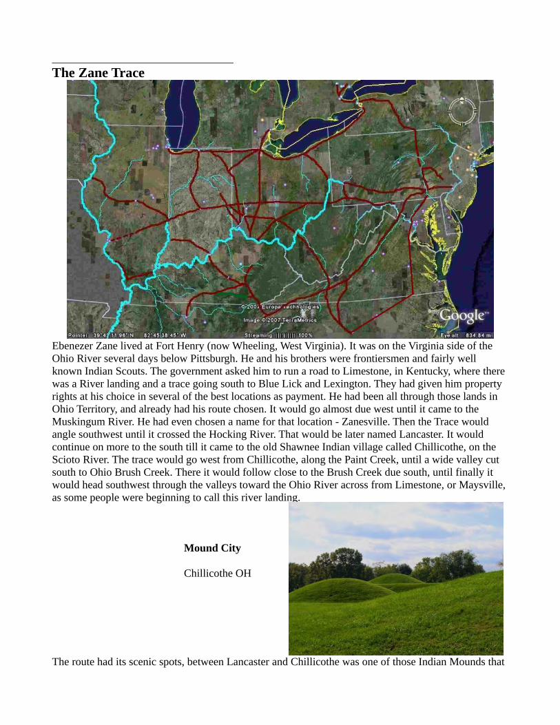
_________________________________The Zane Trace
Ebenezer Zane lived at Fort Henry (now Wheeling, West Virginia). It was on the Virginia side of the Ohio River several days below Pittsburgh. He and his brothers were frontiersmen and fairly well known Indian Scouts. The government asked him to run a road to Limestone, in Kentucky, where there was a River landing and a trace going south to Blue Lick and Lexington. They had given him property rights at his choice in several of the best locations as payment. He had been all through those lands in Ohio Territory, and already had his route chosen. It would go almost due west until it came to the Muskingum River. He had even chosen a name for that location - Zanesville. Then the Trace would angle southwest until it crossed the Hocking River. That would be later named Lancaster. It would continue on more to the south till it came to the old Shawnee Indian village called Chillicothe, on the Scioto River. The trace would go west from Chillicothe, along the Paint Creek, until a wide valley cut south to Ohio Brush Creek. There it would follow close to the Brush Creek due south, until finally it would head southwest through the valleys toward the Ohio River across from Limestone, or Maysville, as some people were beginning to call this river landing.
Mound City
Chillicothe OH
The route had its scenic spots, between Lancaster and Chillicothe was one of those Indian Mounds that

had an unusual shape; it wasn't so high off the ground, but it looked like a large cross. Then there at Chillicothe, there must be a few hundred of different sizes of mounds of dirt, all grassed over in the trees, a city of them that called “Mound City”. They found that people were buried in them, that it was an ancient Indian Village. Then all along the south side of Paint Creek, on top of the high ridges along it, were what looked like dirt forts, they had dug a ditch all around the top of the different hills, and piled the bank of dirt outside the ditch, just like a fort. And just before you got to the valley going downfrom Paint Creek to Ohio Brush Creek, right beside the creek, there was this huge mound of dirt, maybe twenty feet high, and not that much larger at the base - Seips Mound. There was a ring of mounds around it, ancient craft shops that had been burned and buried as mounds. Just as you got to Ohio Brush Creek, where you went through the pass, there was this largest of all of the dirt forts up on the high hill west of the pass, Fort Hill; and after you got through the pass, on the almost level open field below the hill, there was one of those huge circle mounds with the opening facing east toward the sun. Farther along Brush Creek, on a high bank on the east side, where the creek circled around it, therewas this long wiggly snakelike mound, with a mouth and a ball like thing in its mouth, all of it made of dirt. It looked like a real Serpent Mound. These were the ancient Mound Indians, almost two thousand years ago
Great Serpent Mound
This was the Zane Trace. It was the first trace or white man's path in Ohio. It went west along what is now US 40. Ebenezer Zane did start the town of Zanesville as a trading post. And the famous "Y" bridge in Zanesville is where the Zane Trace separated from the later Old National Road, right there in the middle of the bridge in the middle of where the Licking and Muskingum Rivers come together. The Trace leaves Zanesville on US 22. A few miles out of Zanesville at Jonathan Creek, is the little town of White Cottage and the White Cottage Church of the Brethren, located right on the old trace. At Lancaster the trace headed more southerly on OH 159 to Chillicothe. Just outside Chillicothe, to the Northeast, there seems to have been an early Brethren settlement, and west of Chillicothe are a couple more Brethren communities. The trace went west along Paint Creek on US 50 to Bainbridge, where OH41 follows the Trace south, past Fort Hill State Park, past Strait Creek Church of the Brethren and Woodland Altars Camp.x The Trace follows OH 41 on through Peebles (Marble Furnace Church of the Brethren is just west of town), to West Union and on to Aberdeen, across the Ohio River from Maysville. On top of the Hills on the River at Maysville, is the old town of Limestone.
Not many of the Brethren used the Zane Trace, except where it and the Kanawha Trace ran together going west from Chillicothe, and the Countryman family settlers coming up from Massie's Station on the Ohio River at Three Islands (Manchester OH), to the Strait Creek Church. Dunkard Ridge is the original Brethren settlement just west of town.

___________________________________The Old National Road
Originally called the Cumberland Road, since it was going to the West from Cumberland, Maryland. It started at the end of an early road from Baltimore, Maryland, that went to Cumberland, Maryland, and followed the Pennsylvania path of General Braddock's Army road to Pittsburgh.
Monocacy River Bridge
near Frederck Maryland
In Fayette County, Pennsylvania, passing the historic Fort Necessity, of young George Washington, it headed down the Redstone River to the Monongehela. At Old Fort Redstone, now Brownsville, Pennsylvania, many built flatboats for travel down the Ohio River. It crossed the Monongehela and went on to Washington County, Pennsylvania headed to the Ohio River. It arrived at the Ohio, at Old

Martin's Ferry
National Road crossed theOhio River
old pictureview looking east
Fort Henry, now Wheeling, West Virginia, in 1818. The Old National Road became US 40, and now is paralleled by I-70. The Old National Road left the west bank of the Ohio River in 1825. It continued onacross the state of Ohio, with its destination being the new Capitol of Indiana: Indianapolis. It arrived atRichmond, Indiana, in 1827, but was stopped by, and did not cross the Gorge until 1835, about the timethe road was completed to there. But by then there was Vandalia, the capitol of the new state of Illinois,and the destination for the Road was set at St. Louis, Missouri, which it reached in 1837. Local construction was by sections, connecting them across the state.
Y Bridge
Zanesville OH
(picture:(old Covered Bridge)
Muskingum River flowing right to leftLicking River coming from far right center
Zane Trace to leftNational Road to rightcenter of rivers
The Old National Road followed the Old Zane Trace (1784) from Fort Henry (Wheeling) to Zanesville.At Zanesville the Zane Trace turning southwest to Chillicothe, the Old National Road going west, this was memorialized by the "Y" Bridge. In the very center of the River where the Licking joins the Muskingum, the Covered Bridge (and the modern highway bridge) divided. Go left and you follow the Zane Trace (US 22) past the White Cottage Church of the Brethren, toward Chillicothe. Go right and you follow the Old National Road to Columbus and Dayton. The Brethren settled heavily around Dayton using the Old National Road.

The Road in the east had been poorly built, and had to be rebuilt due to the heavy wagon usage. When the decision was made to push the Road on across the nation, the Road east was rebuilt from this experience and the new Road, on west, was built better from the start. It was built on a right-of-way that was 80 feet wide. It was a "Macadam", fifteen feet wide, built of 3 layers of crushed stone, 15 inches deep in the center, but sloping off to the edges for drainage. The Road was "metal-surfaced" (graded with a metal blade, at least occasionally).
S Bridge
A feature of the Old National Road that can stillbe seen is its S bridges. The builders of theRoad crossed the streams at right angles.Streams do not always flow perpendicular tothe Road, so many of approaches curve up ontothe bridges. Many of the bridges also are highlyarched.
The Old National Road had another feature inits day that one considers to be very modern.About 2 miles east of Richmond, Indiana, inPreble County, Ohio, on US 40, on the southside of the Road, was standing a truncated Pine Tree. It had only a few living branches. This was the only one remaining of originally a triangle of 3 Pine Trees: the Old National Road designation of a RestStop.
National Road Mile Stone
gives distancesthis one:Cumberland MD - 225 milesWheeling WVa - 95 miles
between Zanesville - 21 miles - to right (yet to go)and Columbus OH - 32 miles - to left (yet to go)just outside of Jacksontown OH
vicinity of:Flint Ridge/Buckeye Lake
The Road had heavy usage.
From the very first, Richmond, Indiana, recorded traffic of 100 wagons a day. Many were Conestoga Wagons pulled by 4 to 6 horses or oxen. Shipping charges were $10 per ton. Lighter traffic was with "shake-guts", unsprung carts with 2 huge wheels. That is 100 vehicles a day, and herds of animals, going 18-20 miles a day, west!

In 1832, Zanesville counted: 2357 wagons with 3 or more horses 11613 2-horse carriages or wagons 14907 1-horse carriages 35310 horseback riders 16750 horses and mules 24410 sheep - driven 52845 hogs - driven 96323 cattle -driven
Whitewater Gorge
Richmond IN
arrival - 1828 - halted construction
restarted - 1837covered bridgecontinued on west
Indianapolis INVandalia IL
Many of the Brethren came west in 1828 or 1830 on the Old National Road, and the Brethren used the Road for settlement into Indiana and Illinois. In Indiana, there were already several Brethren communities near the Road: the Four Mile, south of Richmond; the Nettle Creek, west of Richmond; and the Ladoga Churches, over near the Wabash in western Indiana; but for most of Indiana and Illinois, the churches were considerably north and migration came west on the Road, then turned north.
Huddleston Farm House
Centerville IN
National Road lodging

Monks Mound
East Saint Louis IL
largest in USCahokia Mounds
Mississippian Culture
Mississippi Riverend of
National Road
At St. Louis, the end of the Old Nation Road was the springboard for migration on the Mississippi and Missouri Rivers to the West, settlements in: Missouri, Iowa, Kansas, Nebraska. The Old National Road is probably one of the most important factors of westward migration in the United States.

____________________________________The Ioway Road
From the book, "Proud Mahaska", written by Semira Ann Philips in 1900, about her family's move to Iowa in 1843, are references to the route they traveled. They took the National Road (US 40) west to Terra Haute IN.
Wabash RiverTerra Haute IN
view is to the north, upstream
They crossed the Wabash River there and turned north along it, going to Paris IL (US150). Going west out of Paris (IL 133), was a 10 mile prairie. Scott's Tavern was on the far edge of the prairie. [It must benoted that while prairie land was easier to farm than clearing the stumps out of timberland, the timber was necessary for the building of houses and barns -hence the best considered homestead was the edge of the prairie, with both prairie farmland and timber for building and firewood.]

This Ioway Road continued angling northwest (IL 133) to near Decatur, where it headed due west to Springfield (US 36). Leaving Springfield they came to Virginia (IL 125), a few miles east of there was "Dutches Tavern" which later became Ashland IL. They crossed the Illinois River at Beardstown, goingto Rushville and north (IL 67) to McComb. There it followed IL 9 to Dallas City and Niota, where it crossed the Mississippi to Fort Madison Iowa. Semira comments that they didn't see a comfortable looking house between Beardstown and Fort Madison.
Illinois River
Beardstown IL
There are several Brethren settlements along this road: south of Springfield, on the headwaters of the Sagamon River is a present Brethren settlement in Macoupin Co; along the Illinois River north of Beardstown are several main Brethren settlements from Astoria to Peoria. The Mormon settlement a Nauvoo IL (before their treck to Salt Lake) has tradition of the presence Brethren (Joseph BeHymer/Bechtelsheimer of 10 Mile Creek, Clermont Co OH -became a Mormon in Illinois and went to Utah).
Nauvoo IL
Mormon Temple
This may be the route used by the BeHymers in the move to near Peoria IL. The family sent packed

goods and the women by steamship down the Ohio and up the Mississippi and Illinois, while the men with livestock and wagons went an unidentified cross-country route. Family records say that the men were approaching the Illinois River, with concerns about how to make contact with their families, whenthey heard a steamboat whistle. On arrival they found that it was the very boat the women were on.
Lincoln Country
This may be the route used by Edmund Toney of the Four Mile, on his move to Fulton Co IL. He left the Four Mile, with two wagons, the dog trotting under the back wagon. His claim to fame was splittingrails with a young Abe Lincoln.
Destination:
Fort Madison IOWA

MissouriNew Madrid Earthquake 1811-1812
11 16 Dec - 2 AM - 8.6 Richter Scale23 Jan - 8.2 R27 Jan for a whole minute 7 Feb - 4 AM 2 severe shocks - 8.9R
Rang Church Bells - Boston MASSTrees fell - Four Mile INMississippi River - "ran upstream"
for 2 hours Reelfoot Lake/OxBow Lakes
Aftershocks - 2 months - 8.0 Richter
X"THE LORD IS COMING - AND I'M NOT READY"
Great Kentucky Revival

i German Speaking People West of the Catawba River in North Carolina 1750 – 1880 written by Lorena Shell Eakerii see: #15 Kanawha Way p60iii his arrival there is in 1773 (not the traditional date of 1765) - see "Who is Elder Jacob Miller?" Brethren Roots V31 #2iv The Wilderness Road, Louisville Courier Journal, March 1960, Robert McDowell – from papers of 1811, stories
and recollections of pioneers, gathered at Brooks Spring.. The pioneer name for what is called Logan’s Path. v see: #19 Louisville-Vincennes Road p78vi Mennonite Quarterly Review, January 1929vii Chaw Raw Hill - is named that because one early migrant father and sons decided to camp on top of the hill, along the
Indian Path. They had killed a turkey for their meal, but just as they were getting ready to cook it -they saw a group of Indian warriors coming down the trail. They dare not start a fire -they "chawed the Turkey – Raw!"
viii Much of this route was determined by Albert Brown, deacon of the Four Mile Church, and county surveyor.ix Story told by Martha Burns Rummel (orphan, raised by Elder John Miller, of the Nettle Creek Church).x About 3 miles west at Locust Grove OH. on Ohio 73 is the Serpent Mound State Park, nationally famous.
Go West, Young Man