Embed Size (px)
Citation preview
2017 UNDERWATER
BRIDGE INSPECTION REPORT
BRIDGE #
DISTRICT: COUNTY: CITY/TOWNSHIP:
Date of Inspection:
Equipment Used:
Inspected By:
Report Written By:
Report Reviewed By:
Final Report Date:
58512
CSAH 52 over KETTLE RIVER
District 1 Pine STURGEON LAKE
09/23/2016
Stromberg, Dan
Dan Stromberg
County Highway AgencyOwner:
MinnesotaSTATE:
UNDERWATER SUMMARY 3
UNDERWATER INSPECTION 4
UNDERWATER INSPECTION PROCEDURES 6
STRUCTURE INVENTORY 7
ELEMENTS 8
PICTURES 12
BRIDGE 58512 UNDERWATER INSPECTION DRAWINGS2016
16
TABLE OF CONTENTS
PAGE NUMBER
Contractor:
(A) Reinspect the submerged substructure units at the normal maximum recommended (NBIS) interval of sixty (60) months.
Collins Engineers, Inc.
9687Contractor Job Number:
RECOMMENDATIONS
REPORT SUMMARY
UNDERWATER INSPECTION
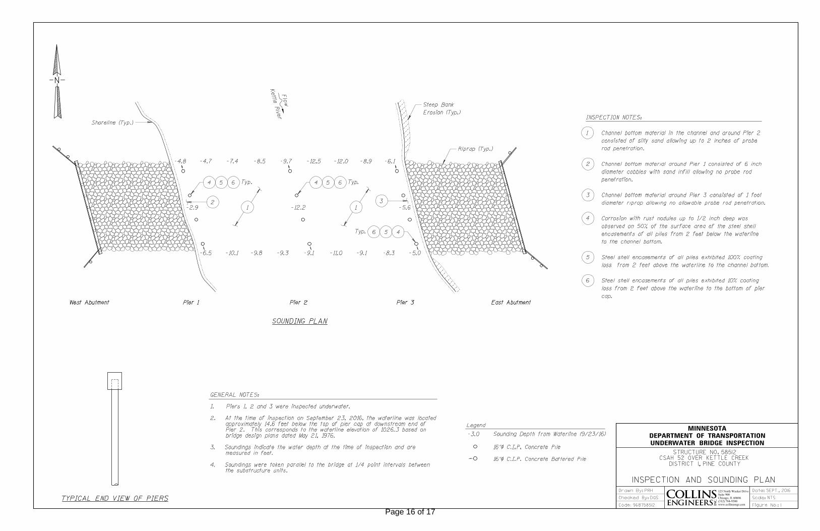
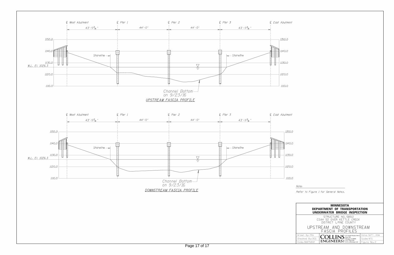
The substructure units inspected at Bridge No. 58512, Piers 1 through 3, were found to be in good condition with no defects of structural significance below water. The steel shell encasements on all of the pier piles exhibited corrosion with rust nodules on approximately 50% of their surface area from 2 feet below the waterline to the channel bottom. Additionally, from 2 feet above the waterline to the channel bottom, the steel encasements exhibited 100% loss of coating, while from 2 feet above the waterline to the bottom of the pier cap steel encasements exhibited 10% loss of coating. Overall, the channel bottom configuration appeared to be in stable condition with no notable scour depressions observed. Erosion was noted at the northeast and southeast banks of the waterway at the bridge.
A. Channel bottom material in the channel and around Pier 2 consisted of silty sand allowing up to 2 inches of probe rod penetration.B. Channel bottom material around Pier 1 consisted of 6 inch diameter cobbles with sand infill allowing no probe rod penetration.C. Channel bottom material around Pier 3 consisted of 1 foot diameter riprap allowing no allowable probe rod penetration. D. Corrosion with rust nodules up to 1/2 inch deep was observed on 50% of the surface area of the steel shell encasements of all piles from 2 feet below the waterline to the channel bottom.E. Steel shell encasements of all piles exhibited 100% coating loss from 2 feet above the waterline to the channel bottom.F. Steel shell encasements of all piles exhibited 10% coating loss from 2 feet above the waterline to the bottom of pier cap.
INSPECTION FINDINGS
Page 3 of 17
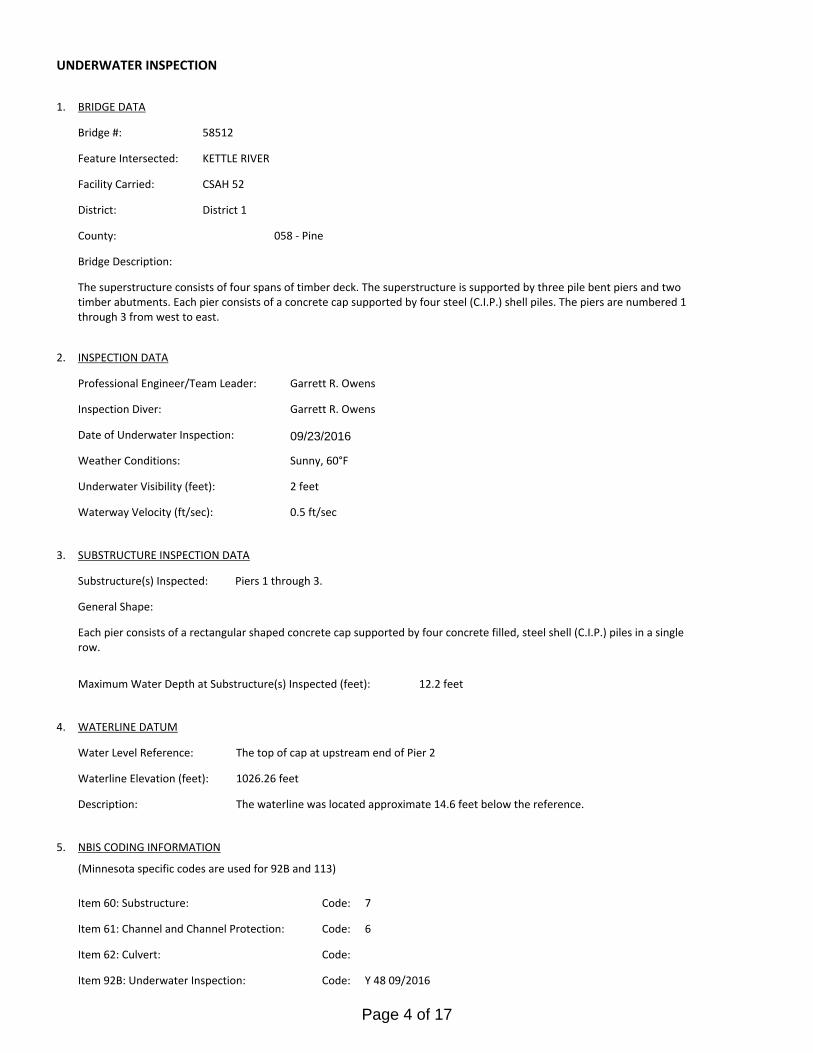
The top of cap at upstream end of Pier 2Water Level Reference:
WATERLINE DATUM
Waterline Elevation (feet):
The waterline was located approximate 14.6 feet below the reference. Description:
1026.26 feet
4.
Piers 1 through 3.Substructure(s) Inspected:
SUBSTRUCTURE INSPECTION DATA
General Shape:
12.2 feetMaximum Water Depth at Substructure(s) Inspected (feet):
Each pier consists of a rectangular shaped concrete cap supported by four concrete filled, steel shell (C.I.P.) piles in a single row.
Code:Item 62: Culvert:
6
Y 48 09/2016Code:Item 92B: Underwater Inspection:
Code:
(Minnesota specific codes are used for 92B and 113)
NBIS CODING INFORMATION5.
Item 60: Substructure:
Item 61: Channel and Channel Protection:
7Code:
District 1District:
CSAH 52
County:
The superstructure consists of four spans of timber deck. The superstructure is supported by three pile bent piers and two timber abutments. Each pier consists of a concrete cap supported by four steel (C.I.P.) shell piles. The piers are numbered 1 through 3 from west to east.
Bridge Description:
058 - Pine
Facility Carried:
BRIDGE DATA1.
UNDERWATER INSPECTION
Bridge #:
KETTLE RIVERFeature Intersected:
58512
Underwater Visibility (feet):
Sunny, 60°FWeather Conditions:
2 feet
3.
0.5 ft/secWaterway Velocity (ft/sec):
09/23/2016
Professional Engineer/Team Leader:
INSPECTION DATA2.
Garrett R. Owens
Date of Underwater Inspection:
Garrett R. OwensInspection Diver:
Page 4 of 17
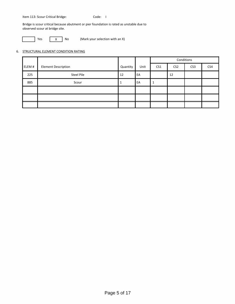
885 Scour 1 EA 1
STRUCTURAL ELEMENT CONDITION RATING
Conditions
6.
I
Bridge is scour critical because abutment or pier foundation is rated as unstable due to observed scour at bridge site.
Item 113: Scour Critical Bridge: Code:
No (Mark your selection with an X)Yes X
225
CS3 CS4
Steel Pile 1212 EA
CS2ELEM # Unit CS1Element Description Quantity
Page 5 of 17
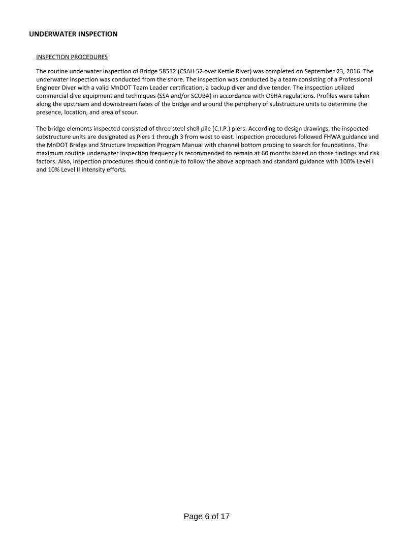
The routine underwater inspection of Bridge 58512 (CSAH 52 over Kettle River) was completed on September 23, 2016. The underwater inspection was conducted from the shore. The inspection was conducted by a team consisting of a Professional Engineer Diver with a valid MnDOT Team Leader certification, a backup diver and dive tender. The inspection utilized commercial dive equipment and techniques (SSA and/or SCUBA) in accordance with OSHA regulations. Profiles were taken along the upstream and downstream faces of the bridge and around the periphery of substructure units to determine the presence, location, and area of scour.
The bridge elements inspected consisted of three steel shell pile (C.I.P.) piers. According to design drawings, the inspected substructure units are designated as Piers 1 through 3 from west to east. Inspection procedures followed FHWA guidance and the MnDOT Bridge and Structure Inspection Program Manual with channel bottom probing to search for foundations. The maximum routine underwater inspection frequency is recommended to remain at 60 months based on those findings and risk factors. Also, inspection procedures should continue to follow the above approach and standard guidance with 100% Level I and 10% Level II intensity efforts.
INSPECTION PROCEDURES
UNDERWATER INSPECTION
Page 6 of 17
Spec. Feat.Pier Foundation (Material/Type)
3 - STEELCantilever ID
+ W A T E R W A Y +Number of Spans Historic Status
4 - PILE BENT
Underwater 60Culvert Type 4 - PILE BENT
Pinned Asbly.
09/23/2016
Barrel Length
176.5 ft. Navigation Control
Waterway Opening (sf.) 1200Structure Length
ft. Year Painted
0 - No nav. control on waterwayDeck Width (Out-to-Out) 34.0
+ P A I N T +
APPR: 0 TOTAL:5 - Not eligible
MAIN: 4
Main Span Length 44.0 ft.Drainage Area (sq. mi.) 486.0
B R I D G E D A T A +Main Span Detail
N - NOT REQUIRED+ M I S C.
Appr. Span Type Structure Flared
GR Termini N - NOT REQUIRED
Appr. Guardrail
Main Span Type 7 - Timber Median Width On Bridge
ft. Bridge Railing 0 - SUBSTANDARD
N - NOT REQUIRED
Main Span Design 01 - Beam Span
ft. GR Transition
Skew 15 LEFT
Y/N Freq Date
Abutment Foundation (Material/Type)
2 - TIMBER Frac. Critical
D E P T H I N S P. +Appr. Span Design
0 - No flare+ I N
Appr. Span Detail Field Conn. ID
Parallel Structure N - No parallel structure
Pier Protection
0 - Not Required
Rating Date 10/01/20125648 sq. ft. Traffic
ft. 50B. Rt 0.00Sidewalk Width 50A. Lt 0.00
Roadway Area (Curb-to-Curb)
Posted Load 0 - Not Required
PostingStructure Area (Out-to-Out) 6001 sq. ft.
DBL:VEH: SEMI:
Rt 06 ARail Type Lt 06 C N - N/AN - N/A B N - N/A
N - Not Applicable Overweight Permit CodesCurb Height Lt
ft. Horizontal 1 - Object Markers
0.75 ft. Vertical0.75 ft. Rt
Wear Surf Install Year 2001
sq. ft. Nav. Vert. Lift Bridge Clear. (ft.)
I - LOW RISK YearPrimer Type MN Scour Code
Painted Area
Unsound Paint % Nav. Clr. (ft.)Deck Material 8 - Wood or Timber 0.0Wear Surf Type 6 - Bituminous
Vert. 0.0 Horiz.
S I G N S +Operating Rating 2 - HS TRUCK
N - Not Applicable (no deck) + B R I D G E
Inventory Rating 2 - HS TRUCK 25.0
36.0Deck Rebars Install Year
Deck Rebars
Finish TypeWear Course/Fill Depth 0.21 ft.
0 - None
Design Load 5 - HS 20
+ C A P A C I T Y R A T I N G S +Deck Membrane
46 ° 21
Inspector Name Stromberg, Dan
Latitude Control Section (TH Only) Status' 38.90 ''
2 - 2-way traffic
Routine Inspection Frequency 12
Sect., Twp., Range
0.5 MI W OF JCT CSAH 61 Level of Service 1 - MAINLINE
- 20W Roadway Type26 - 045N
Detour Length 11.0 mi.R A T I N G S +
Custodian 02 - County Highway Agency
Owner 02 - County Highway AgencyDeck 4 Unsound
Deck %
C O N D I T I O N° 50 '
A - Open
Longitude 92 006+00.370 + N B I 33.85 '' Reference Point
S61 Crew
+ I N S P E C T I O N +
Agency Br. No. 98
District 01
Bridge Match ID (TIS) 0 Userkey
CSAH 52 over KETTLE RIVER
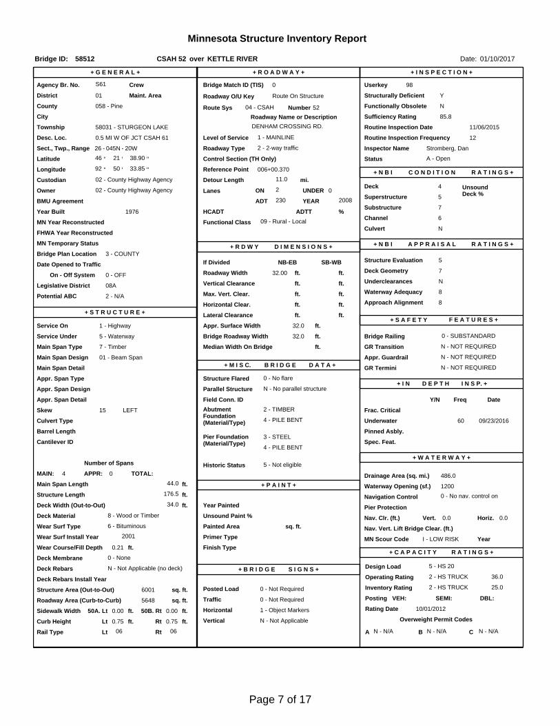
Minnesota Structure Inventory Report
Bridge ID: 58512
+ G E N E R A L + + R O A D W A Y +
Date: 01/10/2017
Sufficiency Rating 85.8Roadway Name or Description
52
City
Routine Inspection Date 11/06/2015
Desc. Loc.
Township 58031 - STURGEON LAKE DENHAM CROSSING RD.
Number
YRoadway O/U Key Route On StructureMaint. Area Structurally Deficient
NRoute Sys 04 - CSAHCounty 058 - Pine Functionally Obsolete
Lanes
Waterway Adequacy 8Max. Vert. Clear.
ft.Legislative District 08Aft.Potential ABC 2 - N/A ft.
ft.On - Off System Roadway Width 32.00 ft.
Vertical Clearance ft.0 - OFF
Underclearances N
Service On 1 - Highway Appr. Surface Width+ S A F E T Y F E A T U R E S +
5 - Waterway Bridge Roadway Width 32.0
32.0 ft.
Service Under
ft.
ft. Approach Alignment 8Horizontal Clear.
ft.
ft.+ S T R U C T U R E + Lateral Clearance
HCADT ADTT7
Year Built 1976
MN Year Reconstructed Functional Class
%Channel 6
Substructure
0Superstructure 5
ON 2 UNDER
230 YEAR 2008BMU Agreement ADT
Structure Evaluation 5If Divided
D I M E N S I O N S +Bridge Plan Location 3 - COUNTY
Deck Geometry 7NB-EB SB-WBDate Opened to Traffic
+ R D W Y
FHWA Year Reconstructed
MN Temporary Status
09 - Rural - LocalCulvert N
A P P R A I S A L R A T I N G S ++ N B I
Page 7 of 17
County:
City:
Township:
Township:Section: Range:
Span Type:
NBI Deck: Super: Sub: Chan: Culv:
Appraisal Ratings - Approach: Waterway:
Required Bridge Signs - Load Posting:
Horizntal:
Traffic:
Vertical:
MN Scour Code:
Open, Posted, Closed:
Location:
Route:
Control Section:
Local Agency Bridge Nbr.:
Ref. Pt.:
Maint. Area:
Length:
Deck Width:
Rdwy. Area/ Pct. Unsnd:
Paint Area/ Pct. Unsnd:
Culvert:
Pine
58031 - STURGEONLAKE
045N26 20W
7 - Wood or Timber 2 -Stringer/Multi-beam or Girder
4 5 7 6 N
8 8
0 - Not Required
1 - Object Markers
0 - Not Required
N - Not Applicable
I - LOW RISK
0.5 MI W OF JCT CSAH 61
04 - CSAH 52
S61
006+00.370
176.5
34.0
5648 sq. ft. / %
sq. ft. / %
N/A
A - Open
ft.
ft.
Postings:List:
MINNESOTA BRIDGE INSPECTION REPORT
01/13/2017
Inspector: CO Bridge
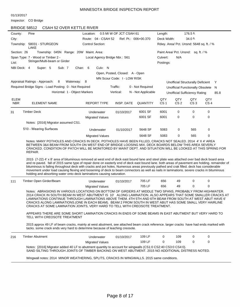
BRIDGE 58512 CSAH 52 OVER KETTLE RIVER
Unofficial Structurally Deficient Y
NUnofficial Functionally Obsolete
Unofficial Sufficiency Rating 85.8
ELEMNBR ELEMENT NAME INSP. DATE QUANTITY
QTYCS 1
QTYCS 2
QTYCS 3
QTYCS 4REPORT TYPE
Timber Deck 01/10/2017 6001 SF 6001 0 0 031 Underwater
6001 SF 6001 0 0 0Migrated Values
Notes: [2016] Migrator assumed CS1.
510 - Wearing Surfaces 5648 SF 5083 0 565 0
Notes: MANY POTHOLES AND CRACKS IN DECK. POTHOLES HAVE BEEN FILLED, CRACKS NOT SEALED. 2014 4' X 4' AREABETWEEN 3&4 BEAM FROM SOUTH ON WEST END OF BRIDGE LOOSING MIX. DECK BOARDS BELOW THIS AREA SEVERLYCRACKED. CONDITION OF PATCH WILL BE MONITORED BY MAINT DEPT. AND SITUATION WILL BE LOOKED AT THIS SPRING FORREPAIR.
2015 (7-22) 4' x 8' area of bituminous removed at west end of deck east bound lane and steel plate was attached over bad deck board areaand re-paved. fall of 2015 same type of repair done on easterly end of deck east bound lane. both areas of pavement are holding. remainder ofbituminous is failing throughout deck with cracks and pot holes. Numerous areas previously pathed and crak filled. deck has considerablemovement under load causing flexing and loosening of deck to beam connectors as well as nails in laminations. severe cracks in bituminousholding and absorbing water onto deck laminations causing saturation.
Underwater 01/10/2017
5648 SF 5083 0 565 0Migrated Values
Timber Open Girder/Beam 01/10/2017 705 LF 656 49 0 0111 Underwater
705 LF 656 49 0 0Migrated Values
Notes: ABRASIONS IN VARIOUS LOCATIONS ON BOTTOM OF GIRDERS AT MIDDLE TWO SPANS, PROBABLY FROM HIGHWATER.2014 CRACK IN SOUTH BEAM IN WEST ABUTMENT IS 10' ALONG LAMINATION. ALSO APPEARS THAT SOME SMALLER CRACKS ATLAMINATIONS CONTINUE THROUGH LAMINATIONS ABOVE THEM. 4TH 5TH AND 6TH BEAM FROM SOUTH AT WEST ABUT HAVE 6'CRACKS ALONG LAMINATIONS.(ONE IN EACH BEAM). BEAM 2 FROM SOUTH IN WEST ABUT HAS SOME SMALL VERY HAIRLINECRACKS AT SOME LAMINATION JOINTS, VERY HARD TO TELL WITH CREOSOTE TREATMENT.
APPEARS THERE ARE SOME SHORT LAMINATION CRACKS IN ENDS OF SOME BEAMS IN EAST ABUTMENT BUT VERY HARD TOTELL WITH CREOSOTE TREATMENT
2015 approx 49 LF of beam cracks, mainly at west abutment, see attached beam crack reference. larger cracks have had ends marked withtacks. some crack ends very hard to determine because of leaching creosote.
Timber Abutment 01/10/2017 109 LF 0 109 0 0216 Underwater
109 LF 0 109 0 0Migrated Values
Notes: [2016] Migrator added 40 LF to abutment quantity to account for wingwalls (CS1:0 CS2:40 CS3:0 CS4:0).SAND SILTING THROUGH JOINTS OF TIMBER BACKING ON WEST ABUTMENT. 2015 NO ADDITIONAL DISTRESS NOTED.
Wingwall notes: 2014 MINOR WEATHERING, SPLITS, CRACKS IN WINGWALLS. 2015 same conditions.
Page 8 of 17
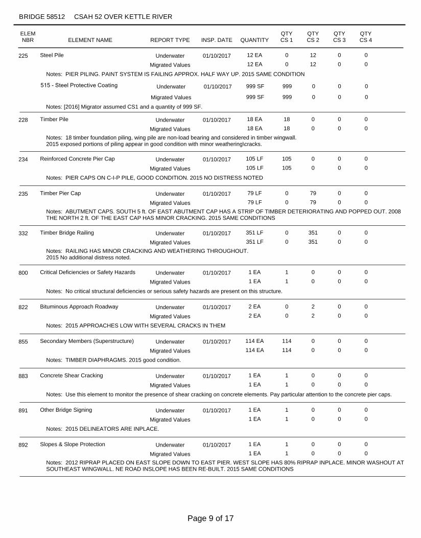
Steel Pile 01/10/2017 12 EA 0 12 0 0225 Underwater
12 EA 0 12 0 0Migrated Values
Notes: PIER PILING. PAINT SYSTEM IS FAILING APPROX. HALF WAY UP. 2015 SAME CONDITION
515 - Steel Protective Coating 999 SF 999 0 0 0
Notes: [2016] Migrator assumed CS1 and a quantity of 999 SF.
Underwater 01/10/2017
999 SF 999 0 0 0Migrated Values
Timber Pile 01/10/2017 18 EA 18 0 0 0228 Underwater
18 EA 18 0 0 0Migrated Values
Notes: 18 timber foundation piling, wing pile are non-load bearing and considered in timber wingwall.2015 exposed portions of piling appear in good condition with minor weathering\cracks.
Reinforced Concrete Pier Cap 01/10/2017 105 LF 105 0 0 0234 Underwater
105 LF 105 0 0 0Migrated Values
Notes: PIER CAPS ON C-I-P PILE, GOOD CONDITION. 2015 NO DISTRESS NOTED
Timber Pier Cap 01/10/2017 79 LF 0 79 0 0235 Underwater
79 LF 0 79 0 0Migrated Values
Notes: ABUTMENT CAPS. SOUTH 5 ft. OF EAST ABUTMENT CAP HAS A STRIP OF TIMBER DETERIORATING AND POPPED OUT. 2008THE NORTH 2 ft. OF THE EAST CAP HAS MINOR CRACKING. 2015 SAME CONDITIONS
Timber Bridge Railing 01/10/2017 351 LF 0 351 0 0332 Underwater
351 LF 0 351 0 0Migrated Values
Notes: RAILING HAS MINOR CRACKING AND WEATHERING THROUGHOUT.2015 No additional distress noted.
Critical Deficiencies or Safety Hazards 01/10/2017 1 EA 1 0 0 0800 Underwater
1 EA 1 0 0 0Migrated Values
Notes: No critical structural deficiencies or serious safety hazards are present on this structure.
Bituminous Approach Roadway 01/10/2017 2 EA 0 2 0 0822 Underwater
2 EA 0 2 0 0Migrated Values
Notes: 2015 APPROACHES LOW WITH SEVERAL CRACKS IN THEM
Secondary Members (Superstructure) 01/10/2017 114 EA 114 0 0 0855 Underwater
114 EA 114 0 0 0Migrated Values
Notes: TIMBER DIAPHRAGMS. 2015 good condition.
Concrete Shear Cracking 01/10/2017 1 EA 1 0 0 0883 Underwater
1 EA 1 0 0 0Migrated Values
Notes: Use this element to monitor the presence of shear cracking on concrete elements. Pay particular attention to the concrete pier caps.
Other Bridge Signing 01/10/2017 1 EA 1 0 0 0891 Underwater
1 EA 1 0 0 0Migrated Values
Notes: 2015 DELINEATORS ARE INPLACE.
Slopes & Slope Protection 01/10/2017 1 EA 1 0 0 0892 Underwater
1 EA 1 0 0 0Migrated Values
Notes: 2012 RIPRAP PLACED ON EAST SLOPE DOWN TO EAST PIER. WEST SLOPE HAS 80% RIPRAP INPLACE. MINOR WASHOUT ATSOUTHEAST WINGWALL. NE ROAD INSLOPE HAS BEEN RE-BUILT. 2015 SAME CONDITIONS
ELEMNBR ELEMENT NAME INSP. DATE QUANTITY
QTYCS 1
QTYCS 2
QTYCS 3
QTYCS 4
BRIDGE 58512 CSAH 52 OVER KETTLE RIVER
REPORT TYPE
Page 9 of 17
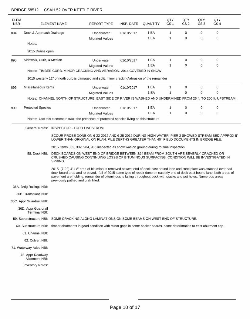
Deck & Approach Drainage 01/10/2017 1 EA 1 0 0 0894 Underwater
1 EA 1 0 0 0Migrated Values
Notes:
2015 Drains open.
Sidewalk, Curb, & Median 01/10/2017 1 EA 1 0 0 0895 Underwater
1 EA 1 0 0 0Migrated Values
Notes: TIMBER CURB. MINOR CRACKING AND ABRASION. 2014 COVERED IN SNOW.
2015 westerly 12" of north curb is damaged and split. minor cracking\abrasion of the remainder
Miscellaneous Items 01/10/2017 1 EA 1 0 0 0899 Underwater
1 EA 1 0 0 0Migrated Values
Notes: CHANNEL NORTH OF STRUCTURE, EAST SIDE OF RIVER IS WASHED AND UNDERMINED FROM 25 ft. TO 200 ft. UPSTREAM.
Protected Species 01/10/2017 1 EA 1 0 0 0900 Underwater
1 EA 1 0 0 0Migrated Values
Notes: Use this element to track the presence of protected species living on this structure.
General Notes:
Inspector's Signature Reviewer's Signature
Inventory Notes:
INSPECTOR - TODD LINDSTROM
SCOUR PROBE DONE ON 6-22-2012 AND 6-25-2012 DURING HIGH WATER. PIER 2 SHOWED STREAM BED APPROX 5'LOWER THAN ORIGINAL ON PLAN. PILE DEPTHS GREATER THAN 40'. FIELD DOCUMENTS IN BRIDGE FILE.
2015 Items 032, 332, 984, 986 inspected as snow was on ground during routine inspection.
58. Deck NBI:
36A. Brdg Railings NBI:
36B. Transitions NBI:
36C. Appr Guardrail NBI:
36D. Appr GuardrailTerminal NBI:
59. Superstructure NBI:
60. Substructure NBI:
61. Channel NBI:
62. Culvert NBI:
71. Waterway Adeq NBI:
72. Appr RoadwayAlignment NBI:
DECK BOARDS ON WEST END OF BRIDGE BETWEEN 3&4 BEAM FROM SOUTH ARE SEVERLY CRACKED ORCRUSHED CAUSING CONTINUING LOSSS OF BITUMINOUS SURFACING. CONDITION WILL BE INVESTIGATED INSPRING.
2015 (7-22) 4' x 8' area of bituminous removed at west end of deck east bound lane and steel plate was attached over baddeck board area and re-paved. fall of 2015 same type of repair done on easterly end of deck east bound lane. both areas ofpavement are holding. remainder of bituminous is failing throughout deck with cracks and pot holes. Numerous areaspreviously pathed and crak filled.
SOME CRACKING ALONG LAMINATIONS ON SOME BEAMS ON WEST END OF STRUCTURE.
timber abutments in good condition with minor gaps in some backer boards. some deterioration to east abutment cap.
ELEMNBR ELEMENT NAME INSP. DATE QUANTITY
QTYCS 1
QTYCS 2
QTYCS 3
QTYCS 4
BRIDGE 58512 CSAH 52 OVER KETTLE RIVER
REPORT TYPE
Page 10 of 17
ELEMNBR ELEMENT NAME INSP. DATE QUANTITY
QTYCS 1
QTYCS 2
QTYCS 3
QTYCS 4
BRIDGE 58512 CSAH 52 OVER KETTLE RIVER
REPORT TYPE
Inspector's Signature Reviewer's Signature
Page 11 of 17
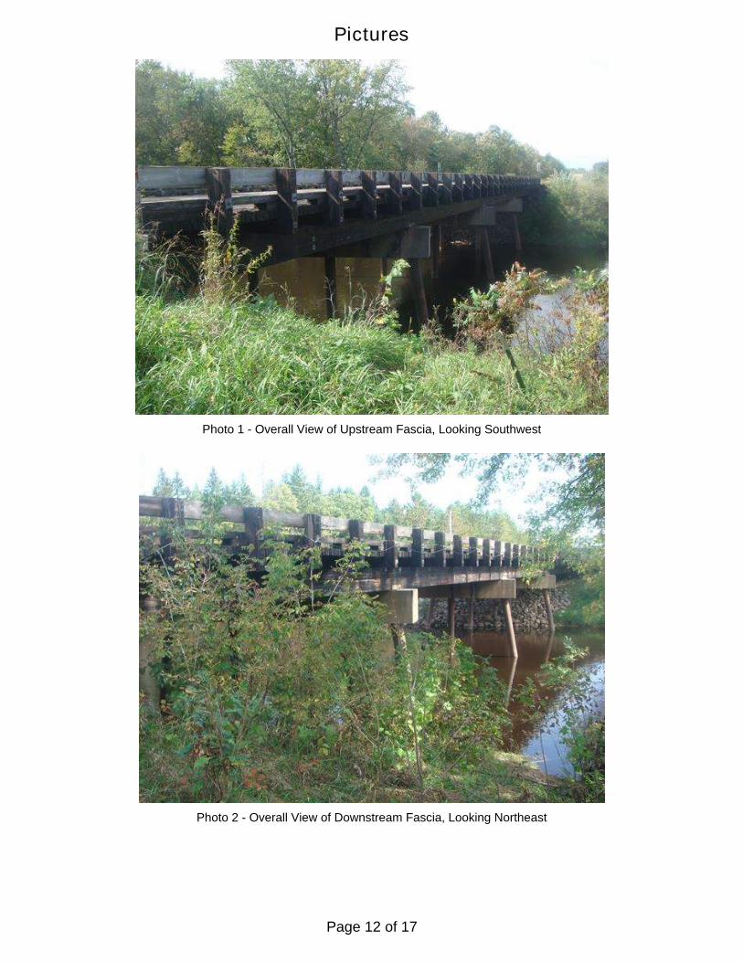
Photo 1 - Overall View of Upstream Fascia, Looking Southwest
Photo 2 - Overall View of Downstream Fascia, Looking Northeast
Pictures
Page 12 of 17
Pictures
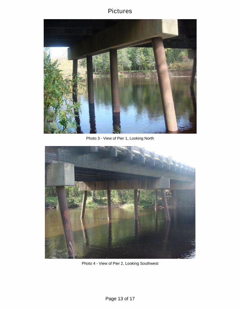
Photo 3 - View of Pier 1, Looking North
Photo 4 - View of Pier 2, Looking Southwest
Page 13 of 17
Pictures
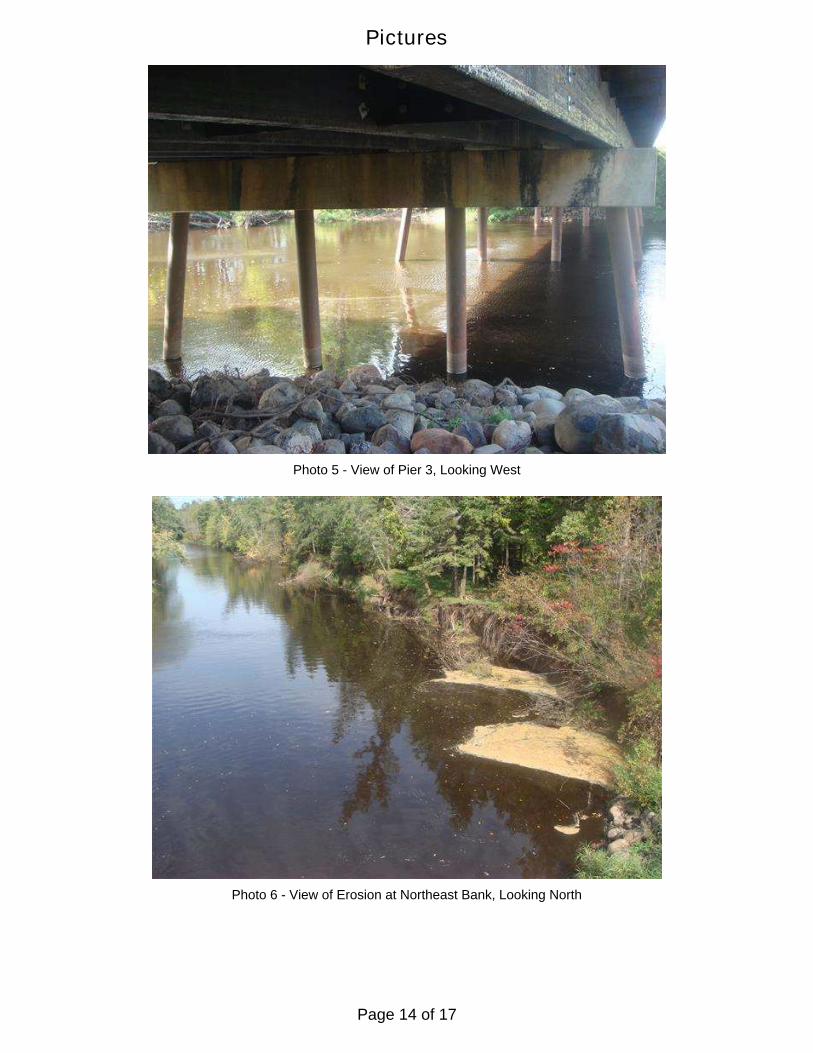
Photo 5 - View of Pier 3, Looking West
Photo 6 - View of Erosion at Northeast Bank, Looking North
Page 14 of 17
Pictures
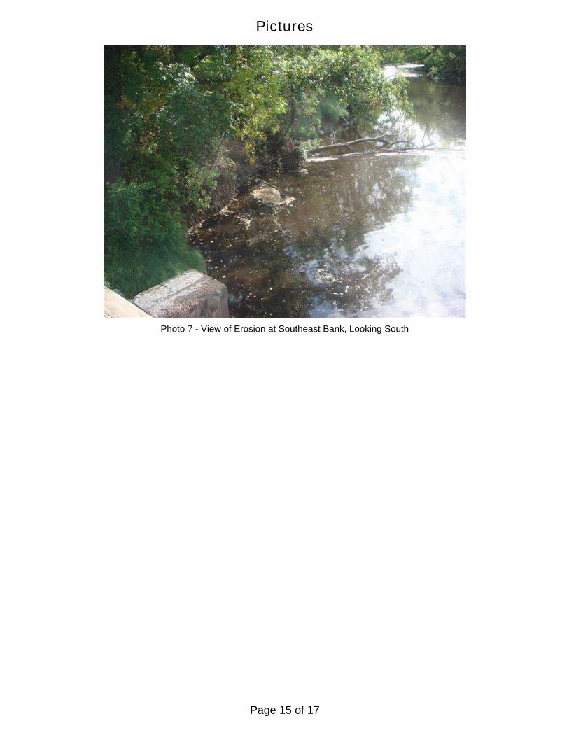
Photo 7 - View of Erosion at Southeast Bank, Looking South
Page 15 of 17
Page 16 of 17
Page 17 of 17