Embed Size (px)
Citation preview
Nat. Hazards Earth Syst. Sci., 13, 85–90, 2013www.nat-hazards-earth-syst-sci.net/13/85/2013/doi:10.5194/nhess-13-85-2013© Author(s) 2013. CC Attribution 3.0 License.
Natural Hazardsand Earth
System Sciences
Brief communication“Landslide Early Warning System: toolbox and general concepts”
E. Intrieri 1, G. Gigli1, N. Casagli1, and F. Nadim2
1Department of Earth Sciences, University of Studies of Florence, via La Pira 4, 50121, Florence, Italy2NGI/ICG (Norwegian Geotechnical Institute/International Centre for Geohazards), P.O. Box 3930 Ulleval Stadion,0806, Oslo, Norway
Correspondence to:E. Intrieri ([email protected])
Received: 25 September 2012 – Revised: 18 December 2012 – Accepted: 27 December 2012 – Published: 18 January 2013
Abstract. We define landslide Early Warning Systems andpresent practical guidelines to assist end-users with limitedexperience in the design of landslide Early Warning Systems(EWSs).
In particular, two flow chart-based tools coming from theresults of the SafeLand project (7th Framework Program)have been created to make them as simple and general as pos-sible and in compliance with a variety of landslide types andsettings at single slope scale. We point out that it is not pos-sible to cover all the real landslide early warning situationsthat might occur, therefore it will be necessary for end-usersto adapt the procedure to local peculiarities of the locationswhere the landslide EWS will be operated.
1 Introduction
Early Warning Systems (EWSs) have been applied to reducethe risk from natural hazards and are defined as “monitoringdevices designed to avoid, or at least to minimize, the impactimposed by a threat on humans, damage to property, the en-vironment, or/and to more basic elements like livelihoods”(Medina-Cetina and Nadim, 2008).
Landslide EWSs have become more applied in recentyears (Anderson et al., 2011; Maskrey, 2011); they generallyhave lower economical and environmental impact than struc-tural interventions, thanks to their capacity to reduce risk byalerting people exposed to the landslide hazard so that theycan take action to avoid or reduce their risk and prepare foreffective response. However, many EWSs suffer from im-balance among their components; for instance some of themmay lack in the instrumental/technical element, some in the
social/communication aspect or in the understanding of land-slide occurrence and their triggers.
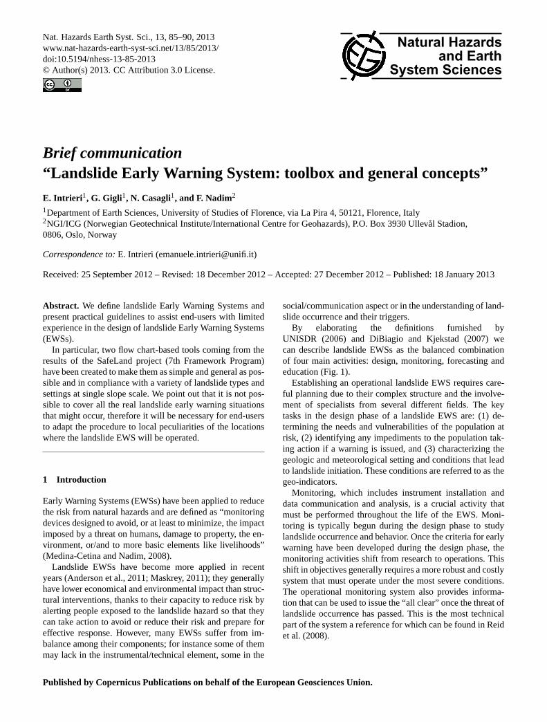
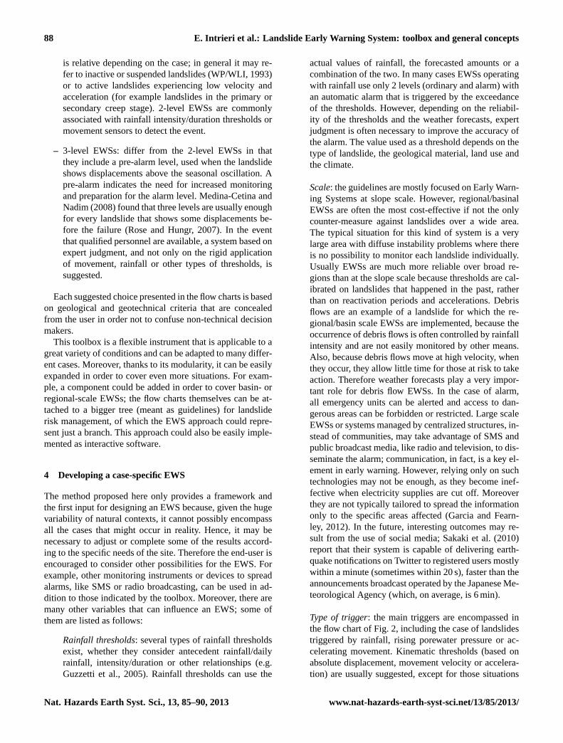
By elaborating the definitions furnished byUNISDR (2006) and DiBiagio and Kjekstad (2007) wecan describe landslide EWSs as the balanced combinationof four main activities: design, monitoring, forecasting andeducation (Fig. 1).
Establishing an operational landslide EWS requires care-ful planning due to their complex structure and the involve-ment of specialists from several different fields. The keytasks in the design phase of a landslide EWS are: (1) de-termining the needs and vulnerabilities of the population atrisk, (2) identifying any impediments to the population tak-ing action if a warning is issued, and (3) characterizing thegeologic and meteorological setting and conditions that leadto landslide initiation. These conditions are referred to as thegeo-indicators.
Monitoring, which includes instrument installation anddata communication and analysis, is a crucial activity thatmust be performed throughout the life of the EWS. Moni-toring is typically begun during the design phase to studylandslide occurrence and behavior. Once the criteria for earlywarning have been developed during the design phase, themonitoring activities shift from research to operations. Thisshift in objectives generally requires a more robust and costlysystem that must operate under the most severe conditions.The operational monitoring system also provides informa-tion that can be used to issue the “all clear” once the threat oflandslide occurrence has passed. This is the most technicalpart of the system a reference for which can be found in Reidet al. (2008).
Published by Copernicus Publications on behalf of the European Geosciences Union.
86 E. Intrieri et al.: Landslide Early Warning System: toolbox and general concepts
Fig. 1. Subdivision of a generic EWS in its four fundamental com-ponents.
Forecasting represents the core element of an EWS as itincludes the definition of thresholds (whose type depends onthe specific case), models and all the activities that lead toa warning. It is also the most problematic one, not just forthe intrinsic difficulty of predicting natural events, but alsofor severe social and legal implications. An excessively highthreshold (of any type, for example a movement velocity ora rainfall intensity and duration threshold) value means thatthe lead time left for the emergency plans will be short and,in the worst case, that the event itself could be missed. Con-versely, a threshold that is too conservative may lead to falsealarms and to all the related problems. In other words: ac-ceptable risk criteria and tolerability of false alarms are twosides of the same coin; their definition helps to determine thepossible range within which the value of the threshold can beset (Nadim and Intrieri, 2011). In any case one has to keepin mind that the possibility of false alarms can be reduced,but cannot be completely nullified; therefore civil protectionplans should encompass this chance as well.
Finally, education is necessary to cover the important so-cial and logistic issues that every EWS must consider in orderto be people-centered (Twigg, 2006). The main objectives ofinstruction are to increase the public risk perception and toexplain correct behaviors to prevent damage or losses. Partic-ular attention must be paid on how to recognize and react tofalse alarms and on conveying the message that, to a certain
extent, they are bound to happen during the life of an EWS.Even though education is a very cost-effective means to re-duce risk, its importance is still sometimes underrated, due tocultural and communication issues (this latter aspect is espe-cially clear in larger communities, where it is more difficultto reach everyone).
One of the aims of the SafeLand project, a large-scale, in-tegrating project of the European 7th Framework Programmethat involved 27 partners from 12 European Countries, wasto produce guidelines for landslide EWSs in Europe to con-tribute to the development of landslide EWSs. In this paperthe focus is set on individual slope scale systems.
2 Guidelines
The SafeLand project was focused on developing genericquantitative risk assessment and management tools andstrategies for landslides at local, regional, European and soci-etal scales. It also aims at establishing the baseline for the riskassociated with landslides in Europe, to improve our abilityto forecast landslide hazard and detect hazard and risk zones.As a consequence, the purpose of the research done in oneof the key areas of the SafeLand project was to develop atoolbox that can help end-users (such as civil protections andadministrations) to create a landslide Early Warning Systemfor every need (SafeLand, 2011).
Designing an EWS is a complex task. Many factors suchas scale, type of landslide, risk scenarios, available resources,etc. must be considered. The variability that can be encoun-tered when dealing with landslides is so large that it makesEWSs extremely site-specific. For this reason, a certain de-gree of simplification is required when building a generaltoolbox. Furthermore, EWSs must foster simplicity (Intrieriet al., 2012), as confusion and loss of time during emergen-cies can worsen the situation; thus the need for a simple andflexible toolbox based on graphic methods match end-usersto the most suitable EWS. The idea behind this toolbox is toprovide an easy-to-use tool for defining the main elementsof an EWS, considering how several factors can vary. Byapplying the toolbox to a case study, the basic structure ofthe system is defined; further customization should also beconsidered in order to fit the system to the specific circum-stances.
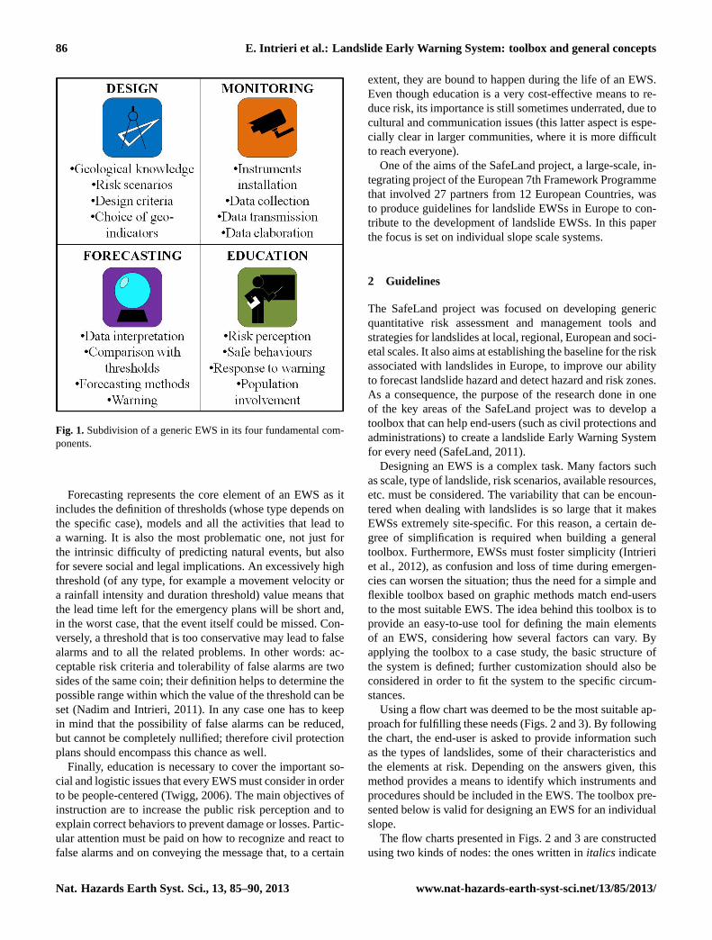
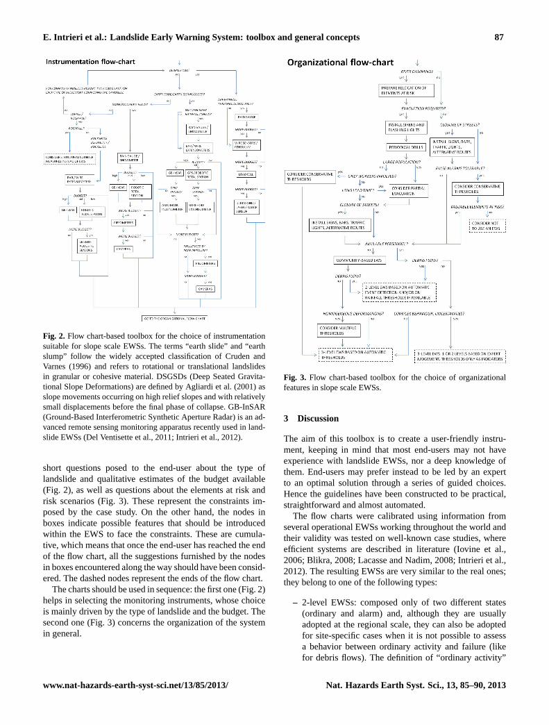
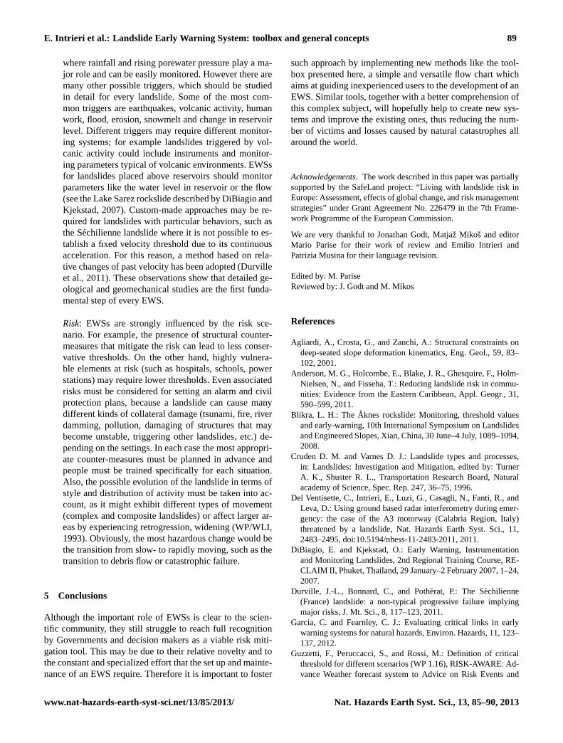
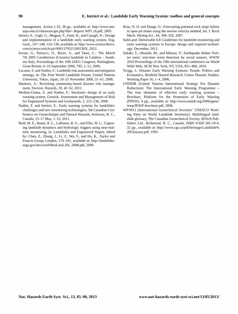
Using a flow chart was deemed to be the most suitable ap-proach for fulfilling these needs (Figs. 2 and 3). By followingthe chart, the end-user is asked to provide information suchas the types of landslides, some of their characteristics andthe elements at risk. Depending on the answers given, thismethod provides a means to identify which instruments andprocedures should be included in the EWS. The toolbox pre-sented below is valid for designing an EWS for an individualslope.
The flow charts presented in Figs. 2 and 3 are constructedusing two kinds of nodes: the ones written initalics indicate
Nat. Hazards Earth Syst. Sci., 13, 85–90, 2013 www.nat-hazards-earth-syst-sci.net/13/85/2013/
E. Intrieri et al.: Landslide Early Warning System: toolbox and general concepts 87
Fig. 2. Flow chart-based toolbox for the choice of instrumentationsuitable for slope scale EWSs. The terms “earth slide” and “earthslump” follow the widely accepted classification of Cruden andVarnes (1996) and refers to rotational or translational landslidesin granular or cohesive material. DSGSDs (Deep Seated Gravita-tional Slope Deformations) are defined by Agliardi et al. (2001) asslope movements occurring on high relief slopes and with relativelysmall displacements before the final phase of collapse. GB-InSAR(Ground-Based Interferometric Synthetic Aperture Radar) is an ad-vanced remote sensing monitoring apparatus recently used in land-slide EWSs (Del Ventisette et al., 2011; Intrieri et al., 2012).
short questions posed to the end-user about the type oflandslide and qualitative estimates of the budget available(Fig. 2), as well as questions about the elements at risk andrisk scenarios (Fig. 3). These represent the constraints im-posed by the case study. On the other hand, the nodes inboxes indicate possible features that should be introducedwithin the EWS to face the constraints. These are cumula-tive, which means that once the end-user has reached the endof the flow chart, all the suggestions furnished by the nodesin boxes encountered along the way should have been consid-ered. The dashed nodes represent the ends of the flow chart.
The charts should be used in sequence: the first one (Fig. 2)helps in selecting the monitoring instruments, whose choiceis mainly driven by the type of landslide and the budget. Thesecond one (Fig. 3) concerns the organization of the systemin general.
Fig. 3. Flow chart-based toolbox for the choice of organizationalfeatures in slope scale EWSs.
3 Discussion
The aim of this toolbox is to create a user-friendly instru-ment, keeping in mind that most end-users may not haveexperience with landslide EWSs, nor a deep knowledge ofthem. End-users may prefer instead to be led by an expertto an optimal solution through a series of guided choices.Hence the guidelines have been constructed to be practical,straightforward and almost automated.
The flow charts were calibrated using information fromseveral operational EWSs working throughout the world andtheir validity was tested on well-known case studies, whereefficient systems are described in literature (Iovine et al.,2006; Blikra, 2008; Lacasse and Nadim, 2008; Intrieri et al.,2012). The resulting EWSs are very similar to the real ones;they belong to one of the following types:
– 2-level EWSs: composed only of two different states(ordinary and alarm) and, although they are usuallyadopted at the regional scale, they can also be adoptedfor site-specific cases when it is not possible to assessa behavior between ordinary activity and failure (likefor debris flows). The definition of “ordinary activity”
www.nat-hazards-earth-syst-sci.net/13/85/2013/ Nat. Hazards Earth Syst. Sci., 13, 85–90, 2013
88 E. Intrieri et al.: Landslide Early Warning System: toolbox and general concepts
is relative depending on the case; in general it may re-fer to inactive or suspended landslides (WP/WLI, 1993)or to active landslides experiencing low velocity andacceleration (for example landslides in the primary orsecondary creep stage). 2-level EWSs are commonlyassociated with rainfall intensity/duration thresholds ormovement sensors to detect the event.
– 3-level EWSs: differ from the 2-level EWSs in thatthey include a pre-alarm level, used when the landslideshows displacements above the seasonal oscillation. Apre-alarm indicates the need for increased monitoringand preparation for the alarm level. Medina-Cetina andNadim (2008) found that three levels are usually enoughfor every landslide that shows some displacements be-fore the failure (Rose and Hungr, 2007). In the eventthat qualified personnel are available, a system based onexpert judgment, and not only on the rigid applicationof movement, rainfall or other types of thresholds, issuggested.
Each suggested choice presented in the flow charts is basedon geological and geotechnical criteria that are concealedfrom the user in order not to confuse non-technical decisionmakers.
This toolbox is a flexible instrument that is applicable to agreat variety of conditions and can be adapted to many differ-ent cases. Moreover, thanks to its modularity, it can be easilyexpanded in order to cover even more situations. For exam-ple, a component could be added in order to cover basin- orregional-scale EWSs; the flow charts themselves can be at-tached to a bigger tree (meant as guidelines) for landsliderisk management, of which the EWS approach could repre-sent just a branch. This approach could also be easily imple-mented as interactive software.
4 Developing a case-specific EWS
The method proposed here only provides a framework andthe first input for designing an EWS because, given the hugevariability of natural contexts, it cannot possibly encompassall the cases that might occur in reality. Hence, it may benecessary to adjust or complete some of the results accord-ing to the specific needs of the site. Therefore the end-user isencouraged to consider other possibilities for the EWS. Forexample, other monitoring instruments or devices to spreadalarms, like SMS or radio broadcasting, can be used in ad-dition to those indicated by the toolbox. Moreover, there aremany other variables that can influence an EWS; some ofthem are listed as follows:
Rainfall thresholds: several types of rainfall thresholdsexist, whether they consider antecedent rainfall/dailyrainfall, intensity/duration or other relationships (e.g.Guzzetti et al., 2005). Rainfall thresholds can use the
actual values of rainfall, the forecasted amounts or acombination of the two. In many cases EWSs operatingwith rainfall use only 2 levels (ordinary and alarm) withan automatic alarm that is triggered by the exceedanceof the thresholds. However, depending on the reliabil-ity of the thresholds and the weather forecasts, expertjudgment is often necessary to improve the accuracy ofthe alarm. The value used as a threshold depends on thetype of landslide, the geological material, land use andthe climate.
Scale: the guidelines are mostly focused on Early Warn-ing Systems at slope scale. However, regional/basinalEWSs are often the most cost-effective if not the onlycounter-measure against landslides over a wide area.The typical situation for this kind of system is a verylarge area with diffuse instability problems where thereis no possibility to monitor each landslide individually.Usually EWSs are much more reliable over broad re-gions than at the slope scale because thresholds are cal-ibrated on landslides that happened in the past, ratherthan on reactivation periods and accelerations. Debrisflows are an example of a landslide for which the re-gional/basin scale EWSs are implemented, because theoccurrence of debris flows is often controlled by rainfallintensity and are not easily monitored by other means.Also, because debris flows move at high velocity, whenthey occur, they allow little time for those at risk to takeaction. Therefore weather forecasts play a very impor-tant role for debris flow EWSs. In the case of alarm,all emergency units can be alerted and access to dan-gerous areas can be forbidden or restricted. Large scaleEWSs or systems managed by centralized structures, in-stead of communities, may take advantage of SMS andpublic broadcast media, like radio and television, to dis-seminate the alarm; communication, in fact, is a key el-ement in early warning. However, relying only on suchtechnologies may not be enough, as they become inef-fective when electricity supplies are cut off. Moreoverthey are not typically tailored to spread the informationonly to the specific areas affected (Garcia and Fearn-ley, 2012). In the future, interesting outcomes may re-sult from the use of social media; Sakaki et al. (2010)report that their system is capable of delivering earth-quake notifications on Twitter to registered users mostlywithin a minute (sometimes within 20 s), faster than theannouncements broadcast operated by the Japanese Me-teorological Agency (which, on average, is 6 min).
Type of trigger: the main triggers are encompassed inthe flow chart of Fig. 2, including the case of landslidestriggered by rainfall, rising porewater pressure or ac-celerating movement. Kinematic thresholds (based onabsolute displacement, movement velocity or accelera-tion) are usually suggested, except for those situations
Nat. Hazards Earth Syst. Sci., 13, 85–90, 2013 www.nat-hazards-earth-syst-sci.net/13/85/2013/
E. Intrieri et al.: Landslide Early Warning System: toolbox and general concepts 89
where rainfall and rising porewater pressure play a ma-jor role and can be easily monitored. However there aremany other possible triggers, which should be studiedin detail for every landslide. Some of the most com-mon triggers are earthquakes, volcanic activity, humanwork, flood, erosion, snowmelt and change in reservoirlevel. Different triggers may require different monitor-ing systems; for example landslides triggered by vol-canic activity could include instruments and monitor-ing parameters typical of volcanic environments. EWSsfor landslides placed above reservoirs should monitorparameters like the water level in reservoir or the flow(see the Lake Sarez rockslide described by DiBiagio andKjekstad, 2007). Custom-made approaches may be re-quired for landslides with particular behaviors, such asthe Sechilienne landslide where it is not possible to es-tablish a fixed velocity threshold due to its continuousacceleration. For this reason, a method based on rela-tive changes of past velocity has been adopted (Durvilleet al., 2011). These observations show that detailed ge-ological and geomechanical studies are the first funda-mental step of every EWS.
Risk: EWSs are strongly influenced by the risk sce-nario. For example, the presence of structural counter-measures that mitigate the risk can lead to less conser-vative thresholds. On the other hand, highly vulnera-ble elements at risk (such as hospitals, schools, powerstations) may require lower thresholds. Even associatedrisks must be considered for setting an alarm and civilprotection plans, because a landslide can cause manydifferent kinds of collateral damage (tsunami, fire, riverdamming, pollution, damaging of structures that maybecome unstable, triggering other landslides, etc.) de-pending on the settings. In each case the most appropri-ate counter-measures must be planned in advance andpeople must be trained specifically for each situation.Also, the possible evolution of the landslide in terms ofstyle and distribution of activity must be taken into ac-count, as it might exhibit different types of movement(complex and composite landslides) or affect larger ar-eas by experiencing retrogression, widening (WP/WLI,1993). Obviously, the most hazardous change would bethe transition from slow- to rapidly moving, such as thetransition to debris flow or catastrophic failure.
5 Conclusions
Although the important role of EWSs is clear to the scien-tific community, they still struggle to reach full recognitionby Governments and decision makers as a viable risk miti-gation tool. This may be due to their relative novelty and tothe constant and specialized effort that the set up and mainte-nance of an EWS require. Therefore it is important to foster
such approach by implementing new methods like the tool-box presented here, a simple and versatile flow chart whichaims at guiding inexperienced users to the development of anEWS. Similar tools, together with a better comprehension ofthis complex subject, will hopefully help to create new sys-tems and improve the existing ones, thus reducing the num-ber of victims and losses caused by natural catastrophes allaround the world.
Acknowledgements.The work described in this paper was partiallysupported by the SafeLand project: “Living with landslide risk inEurope: Assessment, effects of global change, and risk managementstrategies” under Grant Agreement No. 226479 in the 7th Frame-work Programme of the European Commission.
We are very thankful to Jonathan Godt, Matjaz Mikos and editorMario Parise for their work of review and Emilio Intrieri andPatrizia Musina for their language revision.
Edited by: M. PariseReviewed by: J. Godt and M. Mikos
References
Agliardi, A., Crosta, G., and Zanchi, A.: Structural constraints ondeep-seated slope deformation kinematics, Eng. Geol., 59, 83–102, 2001.
Anderson, M. G., Holcombe, E., Blake, J. R., Ghesquire, F., Holm-Nielsen, N., and Fisseha, T.: Reducing landslide risk in commu-nities: Evidence from the Eastern Caribbean, Appl. Geogr., 31,590–599, 2011.
Blikra, L. H.: The Aknes rockslide: Monitoring, threshold valuesand early-warning, 10th International Symposium on Landslidesand Engineered Slopes, Xian, China, 30 June–4 July, 1089–1094,2008.
Cruden D. M. and Varnes D. J.: Landslide types and processes,in: Landslides: Investigation and Mitigation, edited by: TurnerA. K., Shuster R. L., Transportation Research Board, Naturalacademy of Science, Spec. Rep. 247, 36–75, 1996.
Del Ventisette, C., Intrieri, E., Luzi, G., Casagli, N., Fanti, R., andLeva, D.: Using ground based radar interferometry during emer-gency: the case of the A3 motorway (Calabria Region, Italy)threatened by a landslide, Nat. Hazards Earth Syst. Sci., 11,2483–2495,doi:10.5194/nhess-11-2483-2011, 2011.
DiBiagio, E. and Kjekstad, O.: Early Warning, Instrumentationand Monitoring Landslides, 2nd Regional Training Course, RE-CLAIM II, Phuket, Thailand, 29 January–2 February 2007, 1–24,2007.
Durville, J.-L., Bonnard, C., and Potherat, P.: The Sechilienne(France) landslide: a non-typical progressive failure implyingmajor risks, J. Mt. Sci., 8, 117–123, 2011.
Garcia, C. and Fearnley, C. J.: Evaluating critical links in earlywarning systems for natural hazards, Environ. Hazards, 11, 123–137, 2012.
Guzzetti, F., Peruccacci, S., and Rossi, M.: Definition of criticalthreshold for different scenarios (WP 1.16), RISK-AWARE: Ad-vance Weather forecast system to Advice on Risk Events and
www.nat-hazards-earth-syst-sci.net/13/85/2013/ Nat. Hazards Earth Syst. Sci., 13, 85–90, 2013
90 E. Intrieri et al.: Landslide Early Warning System: toolbox and general concepts
management, Action 1.16, 38 pp., available at:http://www.smr.arpa.emr.it/riskaware/get.php?file=ReportWP1.16.pdf, 2005.
Intrieri, E., Gigli, G., Mugnai, F., Fanti, R., and Casagli, N.: Designand implementation of a landslide early warning system, Eng.Geol., 147–148, 124–136, available at:http://www.sciencedirect.com/science/article/pii/S001379521200230X, 2012.
Iovine, G., Petrucci, O., Rizzo, V., and Tansi, C.: The March7th 2005 Cavallerizzo (Cerzeto) landslide in Calabria – South-ern Italy, Proceedings of the 10th IAEG Congress, Nottingham,Great Britain, 6–10 September 2006, 785, 1–12, 2006.
Lacasse, S. and Nadim, F.: Landslide risk assessment and mitigationstrategy, in: The First World Landslide Forum, United NationsUniversity, Tokyo, Japan, 18–21 November 2008, 31–61, 2008.
Maskrey, A.: Revisiting community-based disaster risk manage-ment, Environ. Hazards, 10, 42–52, 2011.
Medina-Cetina, Z. and Nadim, F.: Stochastic design of an earlywarning system, Georisk: Assessment and Management of Riskfor Engineered Systems and Geohazards, 2, 223–236, 2008.
Nadim, F. and Intrieri, E.: Early warning systems for landslides:challenges and new monitoring technologies, 5th Canadian Con-ference on Geotechnique and Natural Hazards, Kelowna, B. C.,Canada, 15–17 May, 1–15, 2011.
Reid, M. E., Baum, R .L., LaHusen, R. G., and Ellis, W. L.: Captur-ing landslide dynamics and hydrologic triggers using near-real-time monitoring, in: Landslides and Engineered Slopes, editedby: Chen, Z., Zhang, J., Li, Z., Wu, F., and Ho, K., Taylor andFrancis Group, London, 179–191, available at:http://landslides.usgs.gov/docs/reid/Reidetal ISL 2008.pdf, 2008.
Rose, N. D. and Hungr, O.: Forecasting potential rock slope failurein open pit mines using the inverse velocity method, Int. J. RockMech. Mining Sci., 44, 308–320, 2007.
SafeLand: Deliverable 4.8: Guidelines for landslide monitoring andearly warning systems in Europe: design and required technol-ogy, December, 2011.
Sakaki, T., Okazaki, M., and Matsuo, Y.: Earthquake shakes Twit-ter users: real-time event detection by social sensors, WWW2010 Proceedings of the 19th international conference on WorldWide Web, ACM New York, NY, USA, 851–860, 2010.
Twigg, J.: Disaster Early Warning Systems: People, Politics andEconomics, Benfield Hazard Research Centre Disaster Studies,Working Paper 16, 1–4, 2006.
UNISDR (United Nations International Strategy For DisasterReduction): The International Early Warning Programme –The four elements of effective early warning systems –Brochure, Platform for the Promotion of Early Warning(PPEW), 4 pp., available at:http://www.unisdr.org/2006/ppew/iewp/IEWP-brochure.pdf, 2006.
WP/WLI (International Geotechnical Societies’ UNESCO Work-ing Party on World Landslide Inventory): Multilingual land-slide glossary, The Canadian Geotechnical Society, BiTech Pub-lishers Ltd., Richmond, B. C., Canada, ISBN 0-920 505-10-4,32 pp., available at:http://www.cgs.ca/pdf/heritage/Landslide%20Glossary.pdf, 1993.
Nat. Hazards Earth Syst. Sci., 13, 85–90, 2013 www.nat-hazards-earth-syst-sci.net/13/85/2013/