Embed Size (px)
Citation preview

LUND UNIVERSITY
PO Box 117221 00 Lund+46 46-222 00 00
Broad-Scale Patterns in CDOM and Total Organic Matter Concentrations of InlandWaters – Insights from Remote Sensing and GIS
Said Al-Kharusi, Enass
2021
Document Version:Publisher's PDF, also known as Version of record
Link to publication
Citation for published version (APA):Said Al-Kharusi, E. (2021). Broad-Scale Patterns in CDOM and Total Organic Matter Concentrations of InlandWaters – Insights from Remote Sensing and GIS. Lund University.
Total number of authors:1
General rightsUnless other specific re-use rights are stated the following general rights apply:Copyright and moral rights for the publications made accessible in the public portal are retained by the authorsand/or other copyright owners and it is a condition of accessing publications that users recognise and abide by thelegal requirements associated with these rights. • Users may download and print one copy of any publication from the public portal for the purpose of private studyor research. • You may not further distribute the material or use it for any profit-making activity or commercial gain • You may freely distribute the URL identifying the publication in the public portal
Read more about Creative commons licenses: https://creativecommons.org/licenses/Take down policyIf you believe that this document breaches copyright please contact us providing details, and we will removeaccess to the work immediately and investigate your claim.
ENA
SS SAID
AL-K
HA
RU
SI
Broad-Scale Patterns in C
DO
M and T
otal Organic M
atter Concentrations of Inland W
aters 2021
Broad-Scale Patterns in CDOM and Total Organic Matter Concentrations of Inland Waters – Insights from Remote Sensing and GIS
ENASS SAID AL-KHARUSI
DEPARTMENT OF PHYSICAL GEOGRAPHY AND ECOSYSTEM SCIENCE | LUND UNIVERSITY
Department of Physical Geography and Ecosystem Science
Faculty of Science
ISBN 978-91-89187-03-0
NO
RDIC
SW
AN
EC
OLA
BEL
3041
090
3Pr
inte
d by
Med
ia-T
ryck
, Lun
d 20
219
789189
187030
Insights from Remote Sensing and GIS
From pixel to the observation of changes in surface water - This thesis raises the stakes of the capabilities of remote sensing data integrated with GIS applications to extend the explanation of change in colour patterns of inland surface waters to a broad scale and in re-sponse to climate changes, surface runoff and land cover/use changes. Knowledge of these space and time changes are needed to understand the nature of surface water changing (e.g., water browning), that has important consequences for carbon budgets and greenhouse gases in the ecosystems.
”Land, water and the sky are interconnected in an entrenched way that any changes in one will impact the others, hence affect our lives. It is a necessity that we further understand and study these interconnections, by maximizing our use of Remote Sensing technologies, that have become our observing eye on Planet Earth.” Enass Said


1
Broad-Scale Patterns in CDOM and Total Organic Matter Concentrations
of Inland Waters – Insights from Remote Sensing and GIS

2

3
Broad-Scale Patterns in CDOM and Total Organic Matter Concentrations
of Inland Waters – Insights from Remote Sensing and GIS
Enass Said AL-Kharusi
DOCTORAL DISSERTATION
by due permission of the Faculty Science, Lund University, Sweden. To be defended at Auditorium Pangea, Geocentrum II, Sölvegatan 12, Lund. Date
Friday 28 May 2021 and time 2.00 pm.
Faculty opponent Professor Jeffrey Cardille
McGill University

4
Organization LUND UNIVERSITY
Document name DOCTORAL DISSERTATION Date of disputation 2021-05-28
Author(s) Enass Said AL-Kharusi Sponsoring organization
Title and subtitle: Broad-Scale Patterns in CDOM and Total Organic Matter Concentrations of Inland Waters – Insights from Remote Sensing and GIS Abstract The rise in CDOM (coloured dissloved organic matter) is likely to be relatively more pronounced in remote northern regions. However, there is a lack of monitoring to confirm this. For this reason, there is a strong incentive to develop remote sensing-based methods to map CDOM in lakes across broader geographical scales and to include geograghic contex in such analysis. There is a lack of understanding of the mechanisms behind changes in water colour (i.e. CDOM) at large scales. The CDOM variations could be due to varying drivers, such as climate and landscape patterns or catchment features. This means that currently, we do not know the extent to which aquatic ecosystems need conservation efforts, such as management of the surrounding vegetation, to prevent CDOM leakage. Thus, there is need to better understand the drivers behind CDOM changes in inland waters.
Over the last few decades, remote sensing technologies and methods have developed dramatically for terrestrial ecosystems. Coupled with the broader availability of remote sensing data, free access to different data sources and the increased resolution of satellite platforms, remote sensing technology now has a significant impact on land monitoring. Due to the increasing demand for high-quality remote sensing data, the technology continues to improve, which makes remote sensing critical for reducing time and funding costs. Similar to these advances in terrestrial remote sensing, there is an increasing potential to provide information about inland waters by using remote sensing. For instance, recent advancements in designing remote sensors, such as the Landsat 8 operational land imager (OLI) and Sentinel-2 multispectral instrument (MSI), have solved past radiometric sensitivity issues and provide high spatial resolution. This thesis explored CDOM patterns on spatial and temporal scales. The overall aim was to investigate the capabilities of remote sensing (RS) and geographic information systems (GIS) to extend CDOM patterns from a regional to a broad scale. Different study sites in Europe, mainly Northern Scandinavia, including large numbers of lakes and rivers, were tested on different scales.
The results shows how climate changes (from wet to dry) can result in a combination of changes in hydrology, vegetation type and productivity, which can lead to intra-annual variations in the CDOM of recipient waters. It is also shown that drought can temporarily decrease values of CDOM in boreal lakes. In addition, it is demonstrated that combining remote sensing and GIS tools is an effective way to reveal the impact of different catchment parameters and morphometry on lake CDOM concentration. Moreover, the thesis shows that utlizing long-term remote sensing records of CDOM from the last few decades is a successful approach to fill the gaps of the missing lake data from in situ assessments. Finally, the results helped to explore links between water browning and the organic matter degradation rates in temperate European rivers at a continental scale. In conclusion, this thesis demonstrates the pogential use of remote sensing for mapping CDOM in a wide range of inland waters that are situated in complex, inaccessible regions that are not well-monitored. Key words: Inlandwater ,Remote sensing, Sentinel-2 MSI, CDOM, GIS, climate change.
Classification system and/or index terms (if any)
Supplementary bibliographical information Language English
ISSN and key title ISBN 978-91-89187-03-0 Diss. (print)
978-91-89187-04-7 Diss. (pdf)
Recipient’s notes Number of pages 182 Price
Security classification
I, the undersigned, being the copyright owner of the abstract of the above-mentioned dissertation, hereby grant to all reference sources permission to publish and disseminate the abstract of the above-mentioned dissertation.
Signature Date 2019-04-27

5
Broad-Scale Patterns in CDOM and Total Organic Matter Concentrations
of Inland Waters – Insights from Remote Sensing and GIS
Enass Said AL-Kharusi

6
A doctoral thesis at a university in Sweden produced either as monograph or a collection of papers. In the latter case, the introductory part constitutes the formal thesis, which summaries the accompanying paper already published or manuscript at various stages (in press, submitted or in preparation).
Cover photo by Enass Said AL-Kharusi
Copyright pp 1-73 Enass Said AL-Kharusi 2021
Paper 1 © MDPI (Creative Commons Attribution 4.0)
Paper 2 © by the Authors (Manuscript in review)
Paper 3 © by the Authors (Manuscript unpublished)
Paper 4 © WILEY (Open access)
Faculty Department of Physical Geography and Ecosystem Science ISBN (print):978-91-89187-03-0 ISSN (digital): 978-91-89187-04-7 Printed in Sweden by Media-Tryck, Lund University Lund 2020

7
Dedication
THIS THESIS IS DEDICATED TO MY WARM LAND “SULTANATE OF OMAN”

8
Table of Contents
Acknowledgments ........................................................................................ 10 List of papers ............................................................................................... 16 Contributions ................................................................................................ 16 List of Figures ............................................................................................... 17 Abbreviations ............................................................................................... 18
1 Popular Summary in English .................................................................... 20 2 Preface and Specific Aims .......................................................................... 23
2.1 Methodological Objectives: .............................................................. 24 2.2 Thematic Objectives: ........................................................................ 24
3 Motivation, Background and Literature Review .................................... 26 3.1 Introduction ....................................................................................... 26
3.1.1 DOM .................................................................................... 27 3.1.2 The Connection between DOM and CDOM ....................... 27
3.2 Regulation and Functional Role of DOM and CDOM in Ecosystems .......................................................................................... 28 3.2.1 Reactivity of Organic Matter in Water ................................ 28 3.2.2 CDOM at the Global Scale of Carbon Cycle and GHG ...... 29 3.2.3 Seasonal Changes of CDOM and Climate Change .............. 30
3.3 Browning the Waters ........................................................................ 31 3.3.1 CDOM in Boreal Regions .................................................... 31 3.3.2 CDOM in Temperate Rivers ................................................ 32
3.4 Remote Sensing of Water Quality .................................................... 33 3.4.1 CDOM and Spectral Response ............................................ 34 3.4.2 Optical Sensors for Mapping CDOM .................................. 35 3.4.3 Challenges of Optical Remote Sensing in the Boreal
Lakes .................................................................................... 37 3.5 GIS Applications for Inland Waters .................................................. 38
4 Introduction to the Research Papers ........................................................ 39 4.1 Paper I: ‘Large-Scale Retrieval of Coloured Dissolved Organic
Matter in Northern Lakes Using Sentinel-2 Data’ ............................... 39

9
4.1.1 Relevance to the Thesis’ Objectives .................................... 39 4.1.2 Paper Overview .................................................................... 40
4.2 Paper II: ‘Drought Offsets and Weakens the Controls on Coloured Dissolved Organic Matter in Lakes - Insights from Remote Sensing Data’ 41
4.2.1 Relevance to the Thesis’ Objectives .................................... 41 4.2.2 Paper Overview .................................................................... 41
4.3 Paper III: ‘Combined use of Records from Multiple Satellites to Reconstruct Long-Term Trends in Boreal Lakes Brownification’ .. 42 4.3.1 Relevance to the Thesis’ Objectives .................................... 42 4.3.2 Paper Overview .................................................................... 42
4.4 Paper IV: “Decreasing Organic Carbon Bioreactivity in European Rivers’ ................................................................................. 43 4.4.1 Relevance to the Thesis’ Objectives .................................... 43 4.4.2 Paper Overview .................................................................... 43
5 Materials and Methods .............................................................................. 44 5.1 Study Area ......................................................................................... 44 5.2 Methods of In Situ Measurements of DOM ...................................... 45 5.3 Data Compilation and GIS Applications .......................................... 47
6 Implications of Results, Syntheses, and Perspectives .............................. 49 6.1 CDOM Variations in Boreal Lakes with Optical Remote Sensing ... 49
6.1.1 Retrieving CDOM at a Large-Scale and Dealing with Atmospheric Artefacts ......................................................... 50
6.1.2 Spatial and Temporal Variability of CDOM ....................... 52 6.1.3 Regulations of CDOM by Ecosystem and Climate Drivers 53 6.1.4 Thresholding in CDOM in Changing Climate ..................... 55 6.1.5 Reconstructed and Integrated CDOM Using Landsat
and Sentinel-2 ...................................................................... 56 6.2 Water Brownification in Temperate Rivers ...................................... 56
6.2.1 Organic Matter on a Continental Scale ................................ 56 6.2.2 Changes in the Bioreactivity of Organic Matter in Rivers .. 58
7 Conclusion and Final Remarks ................................................................. 60 8 Outlook and Future Work ......................................................................... 62
8.1 Personal Reflection ........................................................................... 62 8.2 Research Needs ................................................................................. 62
9 References ................................................................................................... 64

10
Acknowledgments This thesis writing has been possible due to the financial support from the Oman government- the National Programme of Higher Education- and the Swedish academic system at Lund University.
It has been a long journey full of challenges and difficulties, but there was a lesson behind it, entirely with hopes and patience with every challenge. "Praise be to God for the blessing of patience." It is not enough for me to show my gratitude to everyone who contributed to my life in this journey, be it on scientific or life sides, because they are simply not separated from each other. Everyone has given me a beautiful piece on this journey that will always remain in my mind.
First and foremost, I would express my thanks and gratitude to my principal supervisor Martin Berggren for the PhD project development, project planning and all the assistance and encouragement through this journey. Your door has been always open to discussing any ideas, thoughts, and you gave me my space to develop myself in academia and build my network. Thank you very much for all that you have provided to advance my PhD project in the best way. Thank you very much for introducing me to Tiit Kutser, connecting me to the research group at Umeå University, and supporting me in each step in my PhD project.
I will forever continue to be a witness to the highness of your morals, and you will remain in my memory as a true mentor and teacher of mine. I learned a lot from you!
This assignment of PhD project could not be completed without the tremendous support from my supervisor David Tenenbaum in GIS. You were always available for meetings, any questions, and explanations. You always surprise me by your prompt communications and answer to my emails even late at night. Thank you very much for opening your door always and for your patience in helping me when I got stuck with some GIS files.
I would extend my gratitude to my supervisor Tiit Kutser in remote sensing from the University of Tartu, Estonia, for all the technical support of remote sensing that he provided to me. You have an incredibly sharp mind and very rich experience in remote sensing. I am lucky to have you on my supervision team. Thank you very much for the time we discussed the science and remote sensing aspects of water. Thank you for the opportunity to meet you at the department of Environmental Engineering at EPFL in Switzerland, where we met for the first time. You explained to me all the science behind the pixels of images. We put together the milestone of technical aspects of PhD project. Thank you for joining us in Lund, especially in my half-time seminar, and for your feedback and discussion on water optics.
A special thank you goes to Hakim Abdi, my Co-Supervisor in remote sensing in Lund, for technical support on remote sensing. You are always there when I need
11
you for advice in science. Thank you very much for all the time we spent reviewing the first paper in my thesis. You have such a sharp mind in the field, and I admire your enthusiasm regarding the different perspectives of remote sensing.
Thank you very much, Tiit, David, and Hakim, for proofreading the thesis. I also want to thank all co-authors who contribute to the scientific paper, read the various manuscripts, and provide available feedback; Martin Berggren, David Tenenbaum, Tiit Kutser, and Hakim Abdi, Jan Karlsson, Ann-Kristin Bergström, Geert Hensgens, Clemens Klante, Behshid Khodaei.
Thank you to Adrian, Zhangzhang, Johan, Oskar and Tristan for all the technical supports in data and the open discussion. Johan, thank you very much for your support in python when sometimes I got stuck, you were there to help, and I will never forget that octopus has six legs J
Special thanks to the Remote Sensing Group at Lund. Thank you very much to Lars Eklund and Jonas Ardö for welcoming me to Remote Sensing Group and for all the assistance you provided. Thank you to Virginia Gracia and Per-Ola.
Thank you to my former representative mentor at the department, Ben Smith, and my current representative Lena Ström for ensuring the quality of my PhD work and providing the required support when I needed it. Also, I would like to extend my thanks to the Head of the Department, Jonathan Seaquist, the Director of Studies Ulrik Mårtensson, the Director of PhD Studies Cecilia Akselsson, special thanks to Patrik Vestin and Administration group at the department for their help and support.
I would like to extend my thanks to the faculty at the GIS Centrum; Petter, Karin, Michael, and Olive. My gratitude and deepest thanks to Andreas Persson, I will never forget that you were the first one who welcomed me to Sweden, and you provided all the support that my family and I needed to settle here. Special thanks to you for inviting us to your home and introducing me to your great family. My special thanks also to Ali Mansourian for welcoming me to Sweden, supporting me in moving to my apartment, all help and support he provided, and for introducing me to his beautiful family.
To Altaaf, thank you very much for all the support you gave me through the very hectic time towards the end of my PhD. You were always there when I need you to talk. Thank you very much for the walk and talk and for trying always to think loudly with me.
To all my office mates: Pearl, Sofia, Jeppe, Didac and Tetiana, thank you for the quality talks that we had while we were working at INES. To Klas and Martin Skerlep, thank you for your company while we were in Umeå. To Tomas, Joel and Patryk, thank you.
Special thanks to Hani and Mayra from the biogeochemistry group; I enjoyed your company during the lab meetings, your discussions, and presentations.

12
Beyond my research group and the department, I am very fortunate to meet and work with a wide range of researchers and people from inside and outside Lund University. One significant opportunity is ClimBEco Graduate School, through which I met fantastic people from different backgrounds. My deepest thanks to Katarina Billing for being such a great coach. Thank you for all the support, advice, and lunch when you were here in Lund. My special thanks go to my mentor Åsa Knaggård. I had such an excellent opportunity to meet you, and being my mentor at Lund University, your stands beside me during PhD journey means a lot for me. Hjalmer Laudon offered another important opportunity to join an advanced level of PhD course at Umeå, such an excellent opportunity to meet junior researchers across Europe. Thank you to Karla Munzer from Uppsala University; thank you for an enjoyable field trip to collect samples. In addition, I would like to thank Clemens Klante from LTH at Lund University, such a great opportunity to work and collaborate with you on the water optics project for Bolmen. I wish you all the best for the remaining time for your PhD.
Before I started my PhD journey in Sweden, many great people in my home country Oman supported me to be here in Sweden. I would like to express my deepest and exceptional thanks to Dr. Ghazi Al-Rwas from SQU, who helped me to choose Sweden to pursue my PhD study. In addition, my deepest thanks (Dr to be) Dawood AlYahyai, General Director of Marine Research in Oman, for his continued support during my PhD journey throughout the communications, calls and messages; you are the best! Also, I would like to thank Mohammed Al Amri for his support and encouragement.
Very special thanks to the former Minister of Agriculture and Fisheries Wealth in Oman, HE Dr. Hamed Al Aufi, for his support.
Very special thanks go to Badr Alkindi, the General Director of the Quality Assurance at the Ministry of Higher Education in Oman, for his kindness and support during the time that I processed my PhD application for the National Program of Higher Education in Oman.
Many special thanks to my Representative Supervisor Yusra Al Ismaily from the Culture Attaché of Oman Embassy in London for her continued support. You were always available to talk and discuss matters related to my PhD.
Beyond my PhD project, there are many friends in Sweden and Denmark who I call "Friends of the life." I am very fortunate to meet such lovely hearts around me without any prior plans; only destiny put us all together. First, I would like to express my deepest thanks to "Aziza Bouhasna" how lucky I was when the train just stopped in Lund instead of Malmö. You expressed all the beautiful smiles to me on the train. Today I see all the beauty of these smiles, a friend is what my heart needs all the time, and you touch my heart deeply with your caring and attention. You are for me, not just a friend; you are the great mentor, sister; you are always there for my son
13
and me. Thank You, Marya and Enass, for the support you gave to me during my field campaign in Gothenburg and you took care of Salim.
Exceptional Thanks to my dear friend "Erica", what a nice person you are. Thank you for all the quality time that we spent together, full of love and joy. Thank you for taking care of my son Salim, dancing and playing with him. Thank you for the trip and the overnight sleep in Norrköpping.
My deepest thanks to my dear friend and neighbour "Nesrin" You are a person filled with love, care and compassion. We were together for such a long time, and you have always treated me as the oldest sister would do without asking, looking after me and my son Salim. Thank you for all the delicious food that you papered for Salim and me regularly, especially when I wrote my thesis. Thank you is not enough for you! Thank you, Tala, for all the assistance, and I wish you all the best and a very bright future.
Special thanks to the lovely heart “Leena”, we knew each other towards the end of my PhD journey, and I am so fortunate to have a friend like you. I wish you all the best in your higher education as well.
To My Family, my parents, I am deeply grateful for the support you provided which made me the person I am. My Siblings, Ahmed and Wesam; thank you very much for the constant calls and messages and for asking about me. Thank you for visiting me in Lund and accepting to stay with me with your lovely kids. Amira, exactly four years ago, you were at my place now, and you papered for your defence at Karolinska Institute in Stockholm; you do not know how much I am proud of you. Keep the excellent science! We had few occasions where we met here in Sweden, and I wish I could spend more quality time with you. Thank you for all the tips and advice. Hussain, thank you for visiting me while you studied in France; thank you for the laughs that you sent on WhatsApp sometimes; I needed them to forget the obstacles that I had. Tariq, thank you for visiting me while you studied in London, and thank you for being caring and compassionate. I wish you all the best in your PhD journey. Maryam, my little sister, thank you for your warmest heart and words, you are the star of the family, and I wish you a very bright future.
To Salim, my son and my ever-greatest friend, you are the world for me. When I decided to pursue my PhD, you were a toddler, and you did not even speak. Time flies, and you are growing very fast. I see the future in your eyes, and you are one of the reasons that I work hard for a better tomorrow. It was a big challenge for me to take care of you and focus on my study during this journey. Thank you for your patience and for all the long hours when you had to stay with me at the office while I processed the data. Thank you for your company to the conference of (Living Planet Symposium) in Milan, and you tried to explore Planet Earth through VR, and we discussed lots of science. I see you are growing with a high interest and curiosity in science and technology. I look up to the future to see you embrace your dreams and ambition.

14
And Finally, I want to thank my beloved man Omar: A companion for the trail and a lifetime. You are my beloved friend who believed in me and you are the friend who whenever I turn to him, I find what I want. Your support for me has not stopped, and you are always there when I need you. You have all my appreciations for the hardship, scarifies, and hard times that you have endured, believing in me. Thank you for being a dedicated coparent, and thank you very much for your patience, great insight, humour, and love. I am genuinely thankful for having you in my life. To me, you are an exceptional man in his wonderful view of his life partner. I look eagerly at the beautiful days that we lived and to the future together. I wish you all the best in the PhD endeavours soon and I hope to give you some of the support that you have given me.
Last but not least being in Sweden to peruse my PhD, it was an excellent opportunity. It gave me a great opportunity to open my eyes to the globe and build a network in science, technology, research, and different organizations. It is a real land of inspiration and the beauty.
نیملاعلا بر + دمحلا " "
Enass Said Lund, Sweden, April 2021

15
﷽"#$% ي>ا $دلحما ،لمعلا بلط في داتهجلاI هداشرو هBقفوت لى- $دلحما ،لABسلا نياده ي>ا $دلحما ،هئاطعو 5ضف لیزج لى- ينلماعلا بر $دلحما
.5هY نم لمعلا لیصتح في برصلI لي- نم
"!"#$% '
()(*+, -./01 23/! !45
7+8(9:; </
01 =>?+@ AB/*(:CE + C(FG*1>H I/:JK: LMN+OP QRSTU1%، A!W?(XY ZH Q[)(\+M] A
Q^\/_/`"
Iءدب يذ ءىد، Yدو Y` Yنع برع bدقتو يركش قیعمو صلاgاول يرhزعلا يgزgیط لي هامدق الم نk حBبر دعب لضفلا مهلف ،ءاطعو لذب نم ماتها .مویلا هیل- `Y الم ينلماعلا
Yبلحا ميxyة،،
`Y رغصلا ذ�م ةیيملعتلا تييرسم ةعبا�م لى- ئماhا كصربح ،مویلا هشY` Y-x ي>ا ليyقت�سم لماعمو �ومط سمرو تي�ش� في غلابلا ر��ا { نكا دقل لیحت�س¡ حومطلا نم ا�xب �ورو بيلق في تxنب نY لىا ،يرعش� نY نود بيلقب حومطلا برد ييرنتو همر�و لمعلا لضف نيBقس� ائماد تنك .تيوخYو ،ةیاد-لاا k©رلما لب�قم في تنك امدنعف ،لمعلا بتارم ىسمY لىا لوصولا في تيوخا لى-و لي- غلابلا كر�Yو كراصرا نع kیجم ةصق تAتك دقل .همده تيلا ةصقلا ¯تل دوعY` Y اه مویلاو .بركY امدنع هیل- نو�Y نY علطتY الم ةروص تيلیمخ �و نم جس�Yو ،رهI لyقت�سلم تيای�مY كعم سمرY تنك .هسمر في نيxتدناس تيلا لملحا {ذ قنا-Y` Yو تاون�س ذ�م اتهAتك
¯ت ثم لاوY الله نينا-Y دقو ،رعشY نY نود ABkنلا لاصلخا هذه ك�م تذYb نيAسحYو ،ةیحضتلاو برصل· لي لاا¶م -ميµ Y -تلزامو تنك دقل ،يسرو ير¿ في ميµ Y تیBح ام يرلخI { وعد�س .ئنمطم بلقبو يدرفبم تµد¼تلا كل لباقY نYو لاوطلا ةبرغلا تاون�س لمتحY نY لى- لاصلخا
.تيAیyح µ نيع ءازلجا يرb كیزيج نY الله وعدYو ،تياولصو ئيا-د في
Yبلحا بيxب،،
Yو كب ائماد رفخIنورقلما يسم Iتيلا ةبیطلا كتافصبو ،كسم Yو ،تيایبح لي ينتلما دن�سلا تلزامو تنك .اهلحمYدو Yن YÈنع بر-� انه ةصرفلا زته Iغل ىدص بيk µ Y©رلا ¯تل نكا دقل .نgدرYÌ ةعماË نم لماشلا رحبب ثيحبلا قیرفل· مضن� ادنل�كسا لىا ةبیطلا ك�قفرو عمد نم لي ه�مدق الم يرgدقت لمعلا ذYb نYو ،دیدË وه ام كل نع علاطلااو ثحبلا فغش يدنع ادازو مویلا هیل- `Y ام حملام ماسر ،اذه ا�موی لىا سيفن في ينلیجم اعقوو .{ذ لى- ةبتترلما ةقشلما تنكا ماÕ اهشxعن تيلا ةBفارغلجا دودلحا جراb ليوضف دمY نYو ،5هY نم
نيان�ما { بر-Y {ذكو .لاؤس يرغب لي نوعلا يمدقتو ،�ومط kصاولم لي ينئماhا كعیجش�و كعمد لى- زgزعلا بيµ Y يرgدقتو يركش قیعم { ءفدو نامY ثعyم امود تنكا فتاهلk Iیوطلا انتاشقا�مو انتµكاح ،لماس نيبا لى-و لي- نانئمطلال ئماhا {اؤسو {اصتا لى- قیمعلا يركشو .ةBفاعلاو يرلخاو ة¼صلI كديم نY رgدقلا ليعلا الله وعدY ،بxبلحا بيµ Y نيع ءازلجا يرb الله كازج .بيµ Y لي
،،،تالحاصلا تمت هتمعنب ي>ا $دلحماو
ةبلمحا كم�ßبا
"ين¼لاçصلا كدابع في كتحمرÌ نيلbدYäو هاضرè ا¼لاص لعمYä نYäو çيhاو لى-و çلي- تمعنYä تيçلا كتمعن ركشYä نYä نيعزوYä بر"
١٥ ةیY ،فاقح�ا ةروس

16
List of papers I. Large-Scale Retrieval of Coloured Dissolved Organic Matter in Northern
Lakes Using Sentinel-2 Data. Enass Said. Al-Kharusi, David E. Tenenbaum, Abdulhakim M. Abdi, Tiit Kutser, Jan Karlsson, Ann-Kristin Bergström and Martin Berggren. “Remote Sensing 12 (1): 157”. https://doi.org/10.3390/rs12010157.
II. Drought Offsets and Weakens the Controls on Colored Dissolved Organic Matter in Lakes-Insights from Remote Sensing Data. Enass Said. Al-Kharusi, Geert Hensgens, Abdulhakim M. Abdi, Tiit Kutser, Jan Karlsson, David E. Tenenbaum, Martin Berggren. Submitted to “Remote Sensing of Environment, 2020”.
III. Combined use of Records from Multiple Satellites to Reconstruct Long-Term Trends in Boreal Lakes Brownification. Enass Said. Al-Kharusi, Clemens Klante, Behshid Khodaei, Tiit Kutser, David E. Tenenbaum, Martin Berggren. “Manuscript”
IV. Decreasing Organic Carbon Bioreactivity in European Rivers. Martin Berggren, Enass Said. Al-Kharusi. “Freshwater Biology 65 (6): 1128–38”. https://doi.org/10.1111/fwb.13498.
Contributions I. ES.A designed the workflow of the research together with the supervisors.
ES.A performed the research, performed the data analysis, interpreted the results and led the writing with the co-authors.
II. ES.A designed the study together with the supervisors. ES.A performed the research. ES.A performed the data analysis with the co-authors and led the writing with the co-authors.
III. ES.A designed the study together with the supervisors. ES.A performed the research, performed the analysis with the co-authors, interpreted the results and led the writing with the co-authors.
IV. ES.A was involved with data analysis by performing of the GIS analyses and involved to interpret the data analysis related to GIS. ES.A edited and approved the manuscript.
17
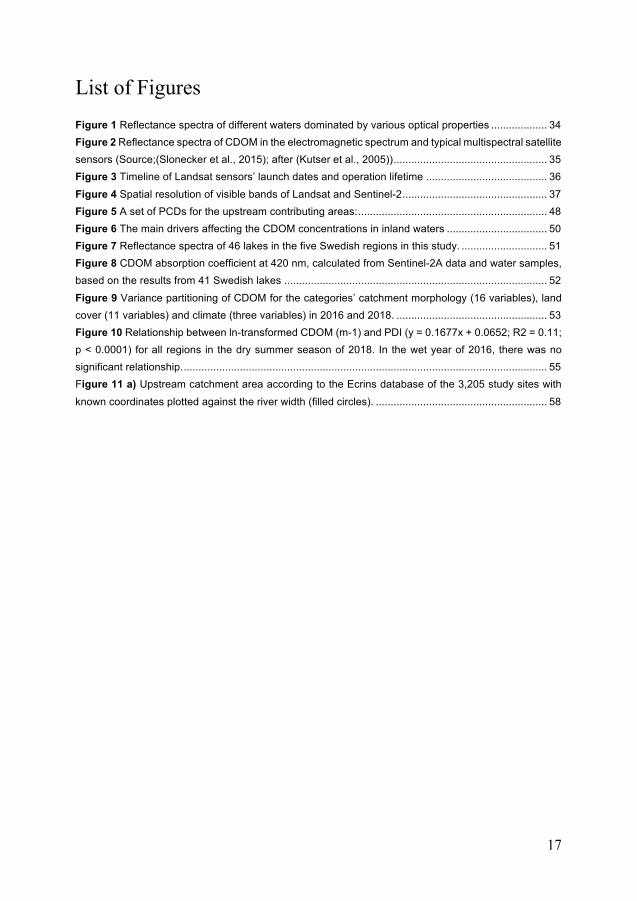
List of Figures Figure 1 Reflectance spectra of different waters dominated by various optical properties ................... 34 Figure 2 Reflectance spectra of CDOM in the electromagnetic spectrum and typical multispectral satellite sensors (Source;(Slonecker et al., 2015); after (Kutser et al., 2005)) .................................................... 35 Figure 3 Timeline of Landsat sensors’ launch dates and operation lifetime ......................................... 36 Figure 4 Spatial resolution of visible bands of Landsat and Sentinel-2 ................................................. 37 Figure 5 A set of PCDs for the upstream contributing areas: ................................................................ 48 Figure 6 The main drivers affecting the CDOM concentrations in inland waters .................................. 50 Figure 7 Reflectance spectra of 46 lakes in the five Swedish regions in this study. ............................. 51 Figure 8 CDOM absorption coefficient at 420 nm, calculated from Sentinel-2A data and water samples, based on the results from 41 Swedish lakes ......................................................................................... 52 Figure 9 Variance partitioning of CDOM for the categories’ catchment morphology (16 variables), land cover (11 variables) and climate (three variables) in 2016 and 2018. ................................................... 53 Figure 10 Relationship between ln-transformed CDOM (m-1) and PDI (y = 0.1677x + 0.0652; R2 = 0.11; p < 0.0001) for all regions in the dry summer season of 2018. In the wet year of 2016, there was no significant relationship. ........................................................................................................................... 55 Figure 11 a) Upstream catchment area according to the Ecrins database of the 3,205 study sites with known coordinates plotted against the river width (filled circles). .......................................................... 58

18
Abbreviations
ALI Advanced Land Imager
BoA Bottom of Atmosphere
BOD5 Biological Oxygen Demand
C:N Carbon: Nitrogen
CDOM Coloured Dissolved Organic Matters
CDOM420 Coloured Dissolved Organic Matters (absorption at 420 nm)
CDOMRS Coloured Dissolved Organic Matters (measured from RS)
CLC CORINE Land Cover
CH4 Methane
Co2 Carbon Dioxide
D8 Eight-Flow Direction Matrix
DEM Digital Elevation Model
DOM Dissolved Organic Matters
EEA European Environmental Agency
ESA European Space Agency
ETM+ Enhanced Thematic Mapper Plus
EU European Union
GEE Google Earth Engine
GHG Green House Gasses
GIS Geographic Information Systems
k The First-Order Decay Coefficient
MK Mann Kendall
MODIS Moderate Resolution Imaging Spectroradiometer
MSI Multispectral Instrument
NASA National Aeronautics and Space Administration
NDVI Normalise Difference Vegetation Index

19
NIR Near Infrared
OLI Operational Land Imager
PCDs Physical Catchment Descriptors
PDI Palmer Drought Index
RHESSys Regional Hydro-Ecological Simulation System
RS Remote Sensing
SeaWiFS Sea-Viewing Wide Field-of-View Sensor
SMHI Swedish Metrological and Hydrological Institute
SRTM Shuttle Radar Topography Mission
SWAT Soil and Water Assessment Tool
TM Thematic Mapper
TN Total Nitrogen
ToA Top of Atmosphere
TOC Total Organic Carbon
TP Total Phosphorus
TMI Topographic Moisture Index
USGS US Geological Survey
UAVs Unmanned Aircraft Vehicle Systems
UV Ultraviolet

20
1 Popular Summary in English
Inland waters are valuable to humankind due to the range of ecosystem services that they provide. Moreover, monitoring of inland water resources is vital to society. However, like many other ecosystems, inland waters have recently been exposed to multiple environmental pressures, such as organic and inorganic pollution. Moreover, as inland water resources are extremely sensitive to land use and climate change, it is a challenge to maintain high-quality water that is clean and free from chemical substances. The surface of water could face significant organic matter input, which usually originates from the soil. This organic matter stains the water yellow or brown, when the concentration of organic matter in the water increases. There is high demand for surface water as a source of drinking water in the Scandinavian region. For example, Sweden and Norway get more than 50 per cent of their drinking water from lakes. The brownification in the water can contribute to several problems, such as disease, odour and bad-tasting drinking water, and it can threaten the sustainability of water resources. The Nordic region has experienced an increase in dissolved organic matter (DOM) in soil, which can travel from the land to lake water through surface runoff from rain or snowmelt water. Moreover, DOM strongly influence the ecosystem’s function through many biogeochemical reactions, and increase the emission of greenhouse gases into the atmosphere. Recently, attention has been devoted to water colour assessments in inland waters by estimating the coloured dissolved organic matter (CDOM), which is considered the main component that can contribute to water brownification. There is a strong link between terrestrial and aquatic ecosystems, as the flux of DOM can emerge from plants and soils and enter water through the process of leaching. There is an urgent need to monitor CDOM changes in inland water surfaces. Conventionally, field data (ground measurements) of CDOM in water have been limited to few measurements at a few places, whereas remote sensing can provide much more data about water colour on both regional and global scales.
This thesis explored CDOM patterns in space and time. The overall aim was to investigate the capabilities of remote sensing (RS) and geographic information systems (GIS) to extend CDOM patterns from a regional to a broad scale. Different study sites in Europe, mainly Northern Scandinavia, including large numbers of

21
lakes and rivers, were tested on different scales. The first two chapters in this thesis focus on the large geographic area that includes many lakes in Sweden and Norway. It was found in the first chapter that data from the satellite Sentinel-2 MSI can be used for lake CDOM retrieval over a wide variety of lakes, and the best-performing algorithm was based on the green/red spectral ratio. Moreover, we found that land cover has a significant impact on CDOM in lakes. Therefore, in Chapter II, we were motivated to investigate the role of catchments and how they could contribute to the shifting CDOM in lakes. The results in Chapter II were obtained from RS and GIS, which provided insights into how CDOM variations during a dry and a wet year were driven by land cover, climate, and shape of the watershed. For the first time, we demonstrated the large-scale geographical CDOM variations in the landscape during drought, which has a strong impact on CDOM in lakes. Notably, droughts affected the large lakes by reduced inflowing water, and therefore, less CDOM was washed into the lakes. The study contributes to the understanding of the drivers controlling CDOM concentrations in inland waters on a regional large scale under severe climate conditions, such as drought.
In Chapter III, Lake Bolmen (Sweden’s tenth largest lake) was chosen for the study because it is an important drinking water source and long-term monitoring data was available. On the regional scale, we explored satellite data sources, such as Landsat and Sentinel-2, and combined different sensors to enable more data from different time points. This is important in cloudy regions, such as Sweden. Furthermore, we used Lake Bolmen as a case study to demonstrate how a combination of data sources can be used to fill gaps in the current understanding of how CDOM has varied over the past decades. It can be concluded that using a combination of remote sensing records from Landsat and Sentinel-2 to reconstruct the long trend of CDOM in lake water is a promising approach.
The last chapter, Chapter IV, focused on the large patterns of temperate rivers on a continental scale. Although these rivers have experienced an increase in the total organic carbon (TOC) due to different scales of factors involving changes in land cover or land use, climate and soil acidity, the results show that the organic matter became more nitrogen poor. Additionally, the findings indicate that biological degradability of the organic material decreased by 50 percent between 1996 and 2012, which coincides with the ongoing water browning trend. However, the results also indicate that the reactivity has increased in river water with a low TOC, where internal processes in the water have a high relative influence on bulk TOC quality, whereas the reactivity is low near terrestrial hot spots for TOC export and during the years with high terrestrial TOC loading. Consequently, these results suggest that the impacts of browning on microbial water deoxygenation and greenhouse gas production are less severe than previously thought.
In conclusion, the combined findings of this thesis highlight the capabilities of remote sensing data integrated with GIS to extend the explanation of CDOM patterns to broad scale in space and time. The different methods and study sites used

22
in this thesis will help to evaluate CDOM variations in response to future climate changes and land cover/use changes, including on a global scale. Knowledge of these space and time changes of CDOM patterns are needed to understand the nature of water browning, which has important consequences for carbon budgets and greenhouse gases in the ecosystem.

23
2 Preface and Specific Aims
A large majority of inland waters are not monitored regularly, and most of them have not been monitored at all, especially small lakes in inaccessible areas. Long-term water quality assessment information is necessary to enhance and restore lake ecosystems. Inland surface water quality has received significant attention globally because much of the world´s population depends on inland resources for potable water, recreation, tourism and sustenance. The remote sensing method, along with in situ water sampling and monitoring programmes for inland water recourses, could play an important role in securing future water resources. In addition, inland water plays an important role in both the global carbon cycle and oceans (see section 3.2.2 for references and further details). Therefore, there is a strong interest to extend the capabilities of remote sensing methods based on satellites’ capacities. Increasing concentrations of dissolved organic carbon (DOC) can result in surface water browning as frequently is reported for the boreal inland waters (Monteith et al., 2007). The widespread phenomenon of water brownification can affect the value of the water, and, as consequences, this will enhance the risk and cost associated with water production (Matilainen et al., 2010), increase the health risk by applying more treatment to the water (McDonald et al., 2005), and the structure and function of the food webs (Creed et al., 2018). Although several studies have developed methods to characterise the optical CDOM of inland waters (Kutser, Pierson, Kallio, et al., 2005; Kutser et al., 2015; Olmanson et al., 2016; Toming et al., 2016), monitoring CDOM ‘brownification’ on a large scale remains difficult. Additionally, using large-scale remote sensing data to monitor surface waters poses a challenge. On a small scale, the potential of reconstructing CDOM in inland waters, coupled with different drivers, such as land cover change and catchment morphometry, have not yet been fully explored. Combining the advantages that are offered by newer sensors can be promising to track water brownification. On a broader scale, the investigation of organic matter quantity in inland waters has not been investigated in depth.
Currently, water monitoring programmes across Europe are in place to monitor water quality parameters, such as water colour. Water colour is rapidly changing, and ‘water browning’ due to increased dissolved organic matter (DOM) concentrations is a persistent issue that has remained over decades (see section 3.3 for references and further details). The increasing DOM load from the terrestrial to

24
the aquatic system could influence the internal processes of the aquatic ecosystem. Overall, browning could cause a shift from bioreactive algal DOM sources to terrestrial DOM, which is characterised by slower degradation.
The rise in CDOM is likely to be relatively more pronounced in remote northern regions; however, there is a lack of monitoring to confirm this. For this reason, there is a strong incentive to develop remote sensing-based methods to map CDOM in lakes across broader geographical scales. There is a lack of understanding of the functioning behind changes in water colour (i.e. CDOM) at large scales. They could be due to varying drivers, such as climate and landscape patterns or catchment features. This means that currently, we do not know the extent to which aquatic ecosystems need conservation efforts, such as reduced fishing pressures and management of the surrounding vegetation, to prevent CDOM leakage. Therefore, there is a need to better understand the process and drivers behind CDOM changes in inland waters. Such a contribution is necessary to increase our knowledge of CDOM shifts within inland waters. The research described in this thesis addresses the methodological and thematic objectives below.
2.1 Methodological Objectives: I. Assess the potential of using high spatial and temporal resolution remote
sensing to explore CDOM dissemination at a large scale (Paper I).
II. Explore the influence of data quality and different water body types in an optical analysis (Paper I and Paper II).
III. Apply GIS techniques/approaches to create morphometry datasets of catchments and inland waters (Paper II, Paper III and Paper IV).
IV. Assess the potential for integrating different sensors at sufficient spatial and temporal resolutions for reconstructing and enhancing CDOM and water colour monitoring (Paper III).
2.2 Thematic Objectives: I. Address CDOM variations both spatially and temporally in different types
of inland waters at a large scale (Paper I and Paper II).
II. Address CDOM changes and determine the influence of different drivers on CDOM in both temperate and boreal environments over large geographic gradients (Paper II and Paper IV).
25
III. Explore the patterns of organic matter in inland waters in both temporal and spatial scales, focusing on organic matter degradation rates in temperate European rivers (Paper IV).
For further elaboration on the research papers that are included in this thesis, see Section 3.

26
3 Motivation, Background and Literature Review
3.1 Introduction Inland surface waters represent major freshwater resources across the world. The importance of inland waters for humankind includes supplying water for drinking, fishing, energy, irrigation, etc. Additionally, they are places of recreation and economic activity that can easily affect the ecosystem´s environmental stability. The quality and colour of inland waters are driven by the different origins of substances and factors, such as nutrients, soil erosion, chemical substances and heavy metals, which are continuously added either naturally from the ecosystem or by human activities (Jaffé et al., 2008; Kritzberg et al., 2020). There is a strong link between water quality and colour, which is related to fundamental changes to the water properties (Kritzberg et al., 2020). Although inland waters comprise a small fraction of the land surface, they are sites of intense biogeochemical activity (Cole et al., 2007). For instance, lakes and rivers are an important source of atmospheric carbon dioxide and a significant component of continental carbon fate(Cole et al., 2007; Tranvik et al., 2009; Raymond et al., 2013; Toming et al., 2020).
Water colour has gradually changed in many inland waters across Europe and North America over the last few decades (Monteith et al., 2007). Recent studies have shown that the change in water colour is one of the major widespread environmental changes that has occurred recently in inland waters (Jonsson et al., 2001; Lapierre et al., 2013; Soares et al., 2019; Kritzberg et al., 2020; Škerlep et al., 2020). Sudden changes to the water colour are due to several factors or a combination of physical, chemical and biological factors in the terrestrial and aquatic systems (Meyer-Jacob et al., 2019). Moreover, the potential drivers of water colour variability are the topography, land use and cover, acid deposition, weather patterns and climate change (Kritzberg et al., 2020). There is a significant relationship with the land surrounding the water surface. which has a direct impact on changes to the water colour. For example, the dissolved decomposition products of DOM in the soil can be efficiently discharged into the surface water via hydrological channels and connections with the land (Tiwari et al., 2017; Rizinjirabake et al., 2018). Additionally, changes to the water colour could occur due to the accumulation of organic matter from the sediments (Bertrand et al., 1993; Von Wachenfeldt et al.,

27
2008). In this respect, inland waters (e.g. lakes and rivers) have been considered a component of the earth's surface that intensely capture, process and transport organic matter from terrestrial soil (Laudon et al., 2011; Soares et al., 2019).
3.1.1 DOM Conventionally, DOM is defined as any organic material that passes through a given filter (0.1 μm –0.7 μm) (Kalbitz et al., 2000). In natural waters, DOM consists of a heterogeneous mixture of autochthonous (internal algal decomposition products) and allochthonous (terrestrial and anthropogenic inputs) material (Von Wachenfeldt et al., 2008; Battin et al., 2009; Li et al., 2016). DOM significantly contributes to the water colour of inland waters that mainly get their brown pigments from surrounding terrestrial ecosystems (Berggren et al., 2018). There is a strong connection between terrestrial and aquatic ecosystems, as the flux of DOM emerges from plants and soils, and it is a significant term in the terrestrial organic matter budget. Fundamentally, DOM strongly influences the ecosystem’s function through many biogeochemical reactions, which could lead to the release of ecosystem labile compounds (e.g. hydrogen sulphide) and greenhouse gases (GHG) (e.g. CO2) (Li et al., 2016; Minor and Oyler, 2021).
3.1.2 The Connection between DOM and CDOM Given the vital importance of organic matter in aquatic systems, it is highly advantageous to measure the concentrations of CDOM across large geographical areas over time (Brando and Dekker, 2003; Erin L. Hestir et al., 2015; Li et al., 2016, 2017). One characteristic property of CDOM is its ability to absorb light, which is conventionally measured in the laboratory as CDOM = ln(1/T440), where T440 is the share of photons that are transmitted through particle-free water per meter at a wavelength of 440 nm (Cuthbert et al., 1992). Generally, CDOM absorbs both short-wavelength solar and ultraviolet (UV) radiation, the CDOM absorption decreases exponentially with increasing wavelength (Hojerslev, 1975). It is crucial to consider that CDOM absorbs most of the radiation in UV, especially in high latitude lakes, because the aquatic biota is protected from UV-B, which induces damage and affects the photochemical reaction. In most aquatic ecosystems, including fresh and coastal waters, quantifying CDOM is equivalent to knowing the absolute concentration of DOM in the water (Brezonik et al., 2015; Harvey et al., 2015), which represents most of the total organic content in the water. Although typically standardised at 440 nm, CDOM absorbs light in the whole ultraviolet spectrum plus visible light, with absorbance coefficients that decrease exponentially from 250 nm and show low values above 550 nm. It is important to highlight that DOM can be variable and controlled by different physical, chemical and biological processes, such as hydrology, photo-modifications and primary production.

28
Variability in the degree of pigmentation of different types of DOM means that the concentration of CDOM does not perfectly correlate with the DOM concentration in the water (Jaffé et al., 2008).
3.2 Regulation and Functional Role of DOM and CDOM in Ecosystems
Recent studies have focused on DOM and CDOM to understand their dynamics, underlying processes and potential implications in ecosystems (Kalbitz et al., 2000; Hestir et al., 2015; Li et al., 2016; Leinemann et al., 2018; Gmach et al., 2020; Minor et al., 2021). DOM contributes to the mobile carbon pool, and it plays an important role in the global carbon cycle (Kalbitz et al., 2000). As expected from organic matter degradation, CO2 tends to increase in the surface water due to the increasing levels of CDOM. However, relationships between DOC to CO2 vary (Lapierre et al., 2013). The analysis of DOM samples' optical properties can be beneficial to assess water colour and understand the relationship between DOM-CDOM and CO2 emissions into the atmosphere (Tranvik et al., 2009).
The fates of DOM and CDOM depend on its interactions with mineral components and the mineralisation and immobilisation processes in the entire ecosystem. These processes are in turn dependent on ecosystem change that affect organic composition, e.g. change in land cover and climate (Kritzberg et al., 2020). In this context, interest in studying the interactions between terrestrial-aquatic ecosystems has increased. The quantity and composition of DOM in inland waters may be influenced by land use and cover (Bodmer et al., 2016). As a result of degradation, DOM becomes less humic and has a lower molecular weight when its ratio increases in croplands, wetlands and water. Thus, the effects of land use/cover change on DOM characteristics should have important implications for carbon cycling in inland water systems (Bodmer et al., 2016; Soares et al., 2019).
3.2.1 Reactivity of Organic Matter in Water The potential of organic matter for degradation is called reactivity. Approximately 30% to 80% of terrestrial DOM is lost due to biological degradation in the water during (bio-reactivity) the transportation process from the catchment to the sea (Algesten et al., 2004). The amount of allochthonous DOM material that is exported from the land to the lakes influences the ecosystem’s resilience, functions, metabolism and food web structure. DOM's relative contribution to the carbon pools in lakes varies depending on the heterogeneity in terrestrial loading and the landscape settings among lakes (Hope et al., 1994; Wilkinson et al. , 2013). High concentrations of reactive DOM in inland waters can lead to enhanced conversion

29
of DOC to CO2 in aquatic ecosystems, which can enhance higher concentrations and fluxes of CO2 into the atmosphere (Sobek, G. Algesten, et al., 2003Algesten et al., 2004).
The differences in carbon composition between allochthonous and autochthonous material could impact the reactivity of DOM and thus aquatic system respiration. Karlsson et al. (2007) showed that different sources of DOM contribute to respiration in aquatic systems, and allochthonous DOM causes net heterotrophic conditions in unproductive lakes. Additionally, allochthonous DOM can significantly regulate the detrital food chains and control the water column's food web production (Berggren et al., 2014).
Different factors can determine DOM reactivity in water, such as chemical and biological factors. There is a connection between the oxidation state and reactivity of aromatic compounds, where decay rate increase when oxidation rate is high (Mostovaya et al., 2017). Besides biological reactivity, CDOM constituents can be highly reactive in sunlit water, which is called photo-reactivity. The photolysis increases the oxidation rate and biological CDOM decay (Berg et al., 2019). Hence, by modifying the DOM, photo-reactivity not only leads to mineralization but is also is could positively affect the microbial DOM degradation rate (Scully et al., 2003). Moreover, DOM bioreactivity vary between the seasons (Isles et al., 2021) due light availability and nutrients, such as total nitrogen (TN) or total phosphorus (TP).
3.2.2 CDOM at the Global Scale of Carbon Cycle and GHG The inland waters on the earth's surface play a major role in the global carbon (C) cycle (Holgerson et al., 2016). Inland waters can influence the climate at the regional and global scales by exchanging heat and water with the atmosphere, which contributes to the release of GHG (Tranvik et al., 2009). The consumption and production of GHG (e.g. carbon dioxide, methane and nitrous oxide) affect both the concentrations of GHG in the atmosphere and the atmosphere's heat budget (Bartosiewicz et al., 2015). Despite the small sizes of inland waters (e.g. lakes and rivers), they are very active sites in a productive ecosystem (Tranvik et al., 2009). The estimated fraction of CDOM in inland waters (lakes) has lower values (0.729 Pg) compared to the global carbon surface of the ocean (700 Pg), the carbon pool in vegetation (450 Pg–650 Pg) and carbon in soils (1500 Pg–2400 Pg) (Toming et al., 2020). Several studies (Tranvik et al., 2009; Bodmer et al., 2016) have shown that lakes are an active site for the transportation, transformation and storage of significant amounts of carbon that originated in the terrestrial environment.
Methane (CH4) and carbon dioxide (CO2) are two GHG that are present in the atmosphere. They have been widely studied recently because of their significant impact on global warming (Wu et al., 2012; Tang et al., 2016). Carbon dioxide has a significant effect on the earth’s climate and is mostly responsible for the

30
greenhouse effect. Methane is the second most important gas that contributes to atmospheric radiative forcing (Tang et al., 2016). Furthermore, more inland waters were recently identified as prime sources of CH4 and CO2(Bodmer et al., 2016; Tang et al., 2016). Dissolved organic matter in water and the surrounding soils are direct sources and inputs of CO2 into the atmosphere due to the extreme respiration of organic matter and high availability of nutrients (Bodmer et al., 2016). The dissolution of organic matter into water results in CH4 being produced through methanogenic processing. Additionally, CH4 can be produced in the water through oxidative processing before reaching the atmosphere. An extreme amount of CH4 can be emitted to the atmosphere by diffusion, effervescence and storage flux (Yang et al., 2015).
Lakes in northern Europe and North America have the largest CDOM concentrations compared to the other continents(Freeman et al., 2001; Skjelkvåle et al., 2005; Monteith et al., 2007b). Although lakes in Africa are very similar to lakes in Europe in terms of the high volume of water, the higher CDOM concentrations in European and North American lakes can be explained by meteorological and hydrological features and the lake morphometry in these regions (Tang et al., 2016).
3.2.3 Seasonal Changes of CDOM and Climate Change Numerous drivers have contributed to changes to the CDOM concentrations in inland waters. Many studies have shown the spatial and seasonal distributions of CDOM and addressed the factors that contribute to the increasing CDOM in lakes, estuaries and rivers (Haaland et al., 2010; Toming et al., 2020). The increasing temperature and precipitation in boreal landscapes has caused them to produce more terrestrial organic matter, which is then transferred from the soil to the aquatic ecosystem (Sobek et al., 2003; Lapierre et al., 2013; Klaus et al., 2019). For instance, hydrological droughts can easily affect the water inflow and availability in the soil in severe climatic conditions (e.g. low precipitation and warmer temperatures) (Lake, 2003; Sobek et al., 2003; Szkokan-Emilson et al., 2017). Additionally, catchment and inland water morphometry can have a strong influence on CDOM in inland waters. (Lake, 2003; Sobek et al., 2003; Szkokan-Emilson et al., 2017) showed how the difference between catchments with respect to their morphometry (e.g. slope, size, area, elevation, etc.) contributes to the export of terrestrial DOM. The lake’s position in the landscape has a strong influence on the CDOM concentration in lakes (Cardille et al., 2007). Toming et al. (2020) emphasised the significant effect of weather and hydrological patterns on the lake water's CDOM concentration availability. Regarding the connection between lake water and terrestrial DOM, Crowther et al. (2016) found larger soil carbon sensitivity patterns for climate warming globally.
Precipitation affects CDOM concentration temporally and is strongly correlated with stream discharge. CDOM can decrease or be offset in the summer due to the

31
reduced precipitation. Furthermore, drought can alter the hydrological network, which effects DOM transportation to the water surface (Toming et al., 2009). (Toming et al., 2009) showed how particular land cover types (e.g. forest, wetlands and vegetation) enhance the CDOM concentration in surface water, especially in headwaters, during spring flood events and in response to diverse chemical variables in the water. Additionally, there is a significant contribution to the catchment’s physical characteristics and lake morphometry. Interestingly, CDOM concentrations have apparent differences that can be observed between large and small, high and low volume and deep and shallow lakes (Lake, 2003; Toming et al., 2020).
3.3 Browning the Waters The phenomenon of increasing CDOM and iron concentrations is called ‘brownification’ or ‘browning water’, and it has a direct impact on the structure and function of aquatic ecosystems (Lake, 2003; Toming et al., 2020b). Browning water has been mainly attributed to the transportation of DOM from terrestrial to aquatic systems. Finstad et al. (2016) mentioned that climate, hydrology and land use are ambient drivers that contribute to brownification when combined with changes in sulphate deposition.
Since brownification has an important ecological impact, as it affects water quality/colour, it has become an environmental concern in many freshwater systems (Kankaala et al., 2019). Moreover, the browning of water has implications for the ecosystem services that freshwater provides, as well as ecological consequences on the aquatic ecosystem, which affect the fish community and production (Kankaala et al., 2019). Many studies have highlighted the implications of browning water (Karlsson et al., 2015; Vasconcelos et al., 2019). Moreover, a high concentration of DOM entering inland waters controls the light penetration in the water column. As a result of the decreased light penetration into the water, a remarkable shift of aquatic ecosystem thermal stability can occur by forming a shallower, warmer epilimnion and euphotic zone. Consequently, the DOM impacts primary production by binding the access of nutrients to the phytoplankton (Williamson et al., 2015; Vasconcelos et al., 2019; Senar, Creed and Trick, 2021).
3.3.1 CDOM in Boreal Regions The ultimate source of CDOM in boreal lakes is terrestrial DOM. In this regard, there is a considerable variation in the export of DOM among catchments to surface inland waters (Laudon et al., 2012). Boreal lakes play a vital role in the carbon cycle, as most of the source of the carbon area comes from the soil stock (Laudon et al.,

32
2012). Biogeochemical activities are considered key to the landscape, as they deliver organic matter from land to water through different mediums of environmental patterns (Sobek et al., 2003; Laudon et al., 2012). The boreal region's catchments are mainly covered with coniferous and mixed forest, which are largely associated with high terrestrial DOM in productive seasons (Laudon et al., 2011). Additionally, there are wetlands in boreal areas, which may vary in abundance among catchments. The area that consists of wetlands has relatively large quantities of organic matter, which are usually well-drained (Mzobe et al., 2018).
Lakes that are located in areas with a high percentage of wetlands and a low elevation have high concentrations of CDOM (Arvola et al.,2016; Mzobe et al., 2020). In addition, lake size and drainage density can play an effective role in increasing the CDOM concentration in lakes (Mzobe et al., 2020). However, the importance of drivers that shape the CDOM concentration in inland waters that shift between climate, landscape properties and hydrological activities is under serious consideration, as they actively contribute to the carbon budget globally. The seasonal cycle in boreal lakes has a characteristic cycle with increasing CDOM in spring after ice and snowmelt while decreasing in the summer and again becoming higher in autumn (Ågren et al., 2008; Kothawala et al., 2014). Advancements in remote sensing technology, GIS and modelling could support efforts to upscale our understanding of CDOM in inland waters at larger geographical scales; therefore, our knowledge of the interface between land and water will be improved.
3.3.2 CDOM in Temperate Rivers DOM may reach surface waters directly by streams as a surface flow or through a subsurface interflow or groundwater inputs. Multiple processes can impact CDOM externally; as this has been addressed in previous sections, internal processes that impact CDOM are the focus of this subsection. Recently, European inland waters (e.g. temperate rivers) have experienced increasing amounts of DOM in their waters(Monteith et al., 2007). However, the concentration of reactive CDOM can increase due to labile terrestrial DOM inputs (Lapierre et al., 2013). The main consequence of increasing CDOM in surface waters is that it can affect food webs, especially phytoplankton. The phytoplankton production and biomass can be lower in browning water because of the limited light availability into the water surface layers (Deininger et al., 2017). Additionally, any changes in land use can cause increasing nitrogen export, which could potentially affect phytoplankton’s growth and activities(Kritzberg et al., 2012). Large inputs of allochthonous DOM are considered to enhance phytoplankton productivity by changing the diatoms, cyanobacteria and mixotrophs, especially in the active pool of CDOM (Senar et al., 2021). The photochemical condition helps to degrade CDOM in water by reacting with the sunlight, which could cause a decline in the oxygen availability in the water(Karlsson et al., 2009; Creed et al., 2018). The internal intrinsic processes that

33
are relevant depend on the source or types of aromatic terrestrial DOM that get into the water (Karlsson et al., 2009)
3.4 Remote Sensing of Water Quality Assessing the water quality using remote sensing applications to measure CDOM in surface water has been of interest to the remote sensing community since the 1970s (Wrigley et al., 1974). Optical remote sensing enables the reconstruction of water quality information for inland waters when a ground data assessment is lacking(Liu et al., 2003; Olmanson et al., 2011; Odermatt et al., 2012; Cardille et al., 2013). Remote sensing data has been successful for estimating water quality parameters, such as total suspended solids, turbidity, chlorophyll-a and CDOM (Kutser, Pierson, Kallio, et al., 2005; Kutser et al., 2016; Olmanson et al., 2016; Liu et al., 2017). The ocean satellites that have been developed for blue water marine remote sensing have coarse spatial resolutions, which makes them ineffective for remote sensing applications for inland water bodies, such as lakes, rivers and reservoirs (Erin Lee Hestir et al., 2015). For example, sensors (e.g. SeaWIFS and MODIS) with large pixel sizes have failed to map small lakes because of the spatial and radiometric resolution issues (Erin Lee Hestir et al., 2015). Land remote sensing satellites have shown progress in effectively measuring inland water quality (Wrigley and Horne, 1974; Kutser et al., 2015; Gholizadeh et al., 2016). From a spatial resolution perspective, Landsat satellites (30 m) allow the measurement of small water bodies. Nowadays, high spatial resolution land satellites, such as Landsat 8 and Sentinel-2, have shown high potential for improving the measurement of water parameters.

34
Figure 1 Reflectance spectra of different waters dominated by various optical properties (Source; Sherry PL, NASA).
3.4.1 CDOM and Spectral Response CDOM, among other water quality parameters, is challenging to retrieve from spectral reflectance data using remote sensing. Several band ratio algorithms have been developed for measuring lake CDOM concentrations, and they are related to water colour and DOM concentrations (Topp et al., 2020). Slonecker et al. (2015) and Toming et al. (2016) showed that the use of bio-optical modelling based on the green to red band ratio can be successfully used to map lake CDOM with a high spatial resolution. Most of the band ratios are based on the blue to green ratio, as water is usually highly responsive. In the blue area of the spectrum, CDOM absorption is high, whereas it is lower in the green (Kutser, 2012) (Figure 2). Moreover, different CDOM-retrieval algorithms have been developed that use green to red band ratios, which work very well over a wide variety of lakes in different parts of the world (Kutser et al., 2005; Olmanson et al., 2016; Slonecker et al., 2015; Toming et al., 2016. Kutser et al. (2005) explained the relationship between the green and red ratio calculated from advanced land imager (ALI) images and CDOM absorption measured from two lakes in southern Finland and southern Sweden, respectively. Toming et al. (2016) used the same relationship for Sentinel-2 images and was able to analyse CDOM absorption in nine lakes in Estonia. Furthermore, the users of the Landsat series mission found significant success in retrieving CDOM using the green and red band ratios (Kutser, 2012; Olmanson et al., 2016).

35
Figure 2 Reflectance spectra of CDOM in the electromagnetic spectrum and typical multispectral satellite sensors (Source;(Slonecker et al., 2015); after (Kutser et al., 2005))
3.4.2 Optical Sensors for Mapping CDOM In this thesis, Landsat 5 TM, Landsat 7 ETM+, Landsat 8 OLI and Sentinel-2 MSI were chosen to assess CDOM ‘water brownification’ because of their high spatial resolution performance that can detect CDOM in the water surface (Pahlevan et al., 2018; Kutser, 2012).
3.4.2.1 Landsat Over the past decade, there have been significant changes in the Landsat programme. After the changes that were made by NASA and the US Geological Survey (USGS) to the Landsat data policy, the Landsat archive became free and open to all users. Therefore, there are now long archive datasets of most Landsat satellites (Wulder et al., 2019). The advancement of technology has helped to improve the Landsat mission to design sensors, such as the Thematic Mapper (TM) onboard Landsat 5, the Enhanced Thematic Mapper Plus (ETM+) onboard Landsat 7 and the most recent OLI onboard Landsat 8 (Figures 3 and 4). There are progressions for each of these sensors to detect or acquire CDOM from a broader range of multispectral bands due to increasing the spatial resolution to 30 m and shorter revisit times (16 days). The Landsat 5 TM archive has data available from 1984, followed by Landsat 7 ETM+ with data available from 1999. Notably, Landsat 6 failed to reach the earth’s orbit in 1993, which was a setback for the program. Landsat 8 OLI was placed into operational service in 2013. However, many studies have proven the capabilities of Landsats 5 TM and 7 ETM+ to map CDOM in lakes and seasonal CDOM (Wulder et al., 2019). Recently, Landsat 8 has

36
shown an improvement over these earlier satellites’ capabilities to estimate CDOM. The high spectral resolution and radiometric sensitivity of Landsat 8 provide a more accurate detection and estimation of changes to water quality (Olmanson et al., 2015; Alcântara et al., 2016; Li et al., 2018; Chen et al., 2019).
Figure 3 Timeline of Landsat sensors’ launch dates and operation lifetime (Source; Young et al., 2017)
3.4.2.2 Sentinel-2 Sentinel-2, which was launched by the European Space Agency (ESA) in 2015, is a significant advancement for remote sensing applications of land monitoring over the Landsat programme mission for land monitoring. The Sentinel-2 constellation consists of two identical satellites (Sentinel-2A and Sentinel-2B) that operate together. The two-satellite constellation allows a five-day revisit time at the Equator and a two-to-three-day revisit time closer to the poles. The unique features of the Sentinel-2 are a wide swath width of 290 km, varying spatial resolution from 10 m to 60 m and 13 spectral bands. It provides a high radiometric and geometric image quality, offers global coverage of land surfaces, and has a high resolution than Landsat-8. Sentinel-2 imagery can provide information about the water properties, which are affected by the reflectance of light. The improvements of the spectral and temporal resolutions of Sentinel-2 (Drusch et al., 2012) allow us to expect greater success in the mapping of CDOM in inland waters. Sentinel-2 could be a great optical tool to provide information on CDOM in inland waters and support for lake management (Olmanson et al., 2015; Alcântara et al., 2016; Li et al., 2018; Chen et al., 2019). The first test of Sentinel-2 was carried out by(Toming et al., 2016) on nine lakes in Estonia, and they found that the green to red band ratio was adequately correlated with lake CDOM. Sentinel-2, with its 10 m spatial resolution, is well

37
suited for capturing CDOM, even in small water bodies (Toming et al., 2016) (Figure 4).
Figure 4 Spatial resolution of visible bands of Landsat and Sentinel-2 (Source; USGS)
3.4.3 Challenges of Optical Remote Sensing in the Boreal Lakes Estimating CDOM from inland waters using optical remote sensing presents several challenges compared to ocean colour remote sensing (Baillarin et al., 2012; ESA, 2015). Many challenges are associated with the estimation of optical properties when ratio type algorithms are developed for boreal inland waters (Kallio et al., 2008; Kutser, 2012; Palmer et al., 2015). One issue is that the water surface's optical properties can vary among different water bodies, which is inherent in the complexity of inland waters in their geographical, biological and chemical characteristics. As a result of the diversity of inland waters, the development of algorithms for inland waters is more complicated than for open ocean waters. The optical shapes of reflectance spectra for CDOM-rich waters can vary greatly, and it depends on what other material is on water and their contribution to the signal (Brezonik et al., 2015).
Brezonik et al. (2005) found that CDOM was typically difficult to estimate over space and time when there was a high concentration of phytoplankton biomass in the aquatic ecosystem. Another complicated issue that is associated with optical remote sensing is atmospheric correction. The optical properties of inland waters can be sensitive to clouds, sun glints and other atmospheric particles (Palmer et al., 2015), which can limit the choices of image availability in the study area.

38
3.5 GIS Applications for Inland Waters Remote Sensing (RS) and GIS can significantly contribute to the assessment of water quality and recourses. Inlands waters are not distributed equally and can affect the water quality all over the world (Radwan et al., 2017; Yang et al., 2020). Allan et al. (1997) emphasised the importance of studying the landscape as an indicator of the level of organic matter movement to inland waters across large geographic gradients. Moreover, (Xu et al., 2020) found that catchment characteristics and landscape patterns influenced water quality seasonally. GIS techniques can generate a set of physical catchment descriptors (PCDs) to characterise watersheds. Consequently, characterising the watershed's contributing area can improve the characterisation and understanding of the dissemination of CDOM in inland waters (e.g. lakes, streams and rivers). The tropical and boreal areas are productive areas because of the high percentage of forest cover that can contribute to shifting DOM from terrestrial to aquatic. Catchment features can correlate strongly with CDOM dissemination in inland waters, as presented by (Xu et al., 2020)Several pertinent descriptors can describe the diverse terrain range of watersheds, such as elevation, slope, mean topographic moisture index (TMI), drainage density and percentage of land cover/use (Mzobe et al., 2020). However, more geospatial analyses are needed in catchments to better define the conceptual framework of the controls of CDOM in inland waters under different mechanisms.
39
4 Introduction to the Research Papers
The extent and causes of increasing freshwater CDOM are still debated because the data that is required to assess CDOM in many areas is not available. The four papers that are part of this thesis provide insight into the understanding of how ‘browning water’ develops over time in a large geographical area. Coupling CDOM with drivers, such as climate, land use/cover and catchment morphology, will contribute greatly to conceptualising water brownification. The first paper is based on Sentinel-2’s data that is used to map CDOM in lakes across landscape gradients that are distributed in five regions in Sweden. The second paper deals with a specific driver, such as climate, land cover or catchment morphology, that can enhance CDOM in boreal lakes using an integration of GIS and remote sensing datasets. In Paper III, the Landsat series of satellites and Sentinel-2 are used to reconstruct CDOM over the past three decades, using Lake Bolmen as a case study site. In the fourth paper, datasets of river organic matter and its bio-reactivity across continental Europe are evaluated in 25 countries from different perspectives, considering the catchment types and river morphometry features.
4.1 Paper I: ‘Large-Scale Retrieval of Coloured Dissolved Organic Matter in Northern Lakes Using Sentinel-2 Data’
4.1.1 Relevance to the Thesis’ Objectives The first paper contributes to both the methodological and thematic objectives of the thesis. From a methodological perspective, the utility of Sentinel-2 is examined to assess the potential of using high spatial and temporal resolution imagery to explore the CDOM distribution at a large scale (Objective 1). The accuracy of the Sentinel-2 products was also tested from non-atmospherically corrected and atmospherically corrected data by evaluating the CDOM values to assess any residuals errors among a variety of water body types (Objective 2). From a thematic perspective, we explored different types of lakes according to their geographical settings and sizes to address CDOM variations both spatially and temporally at a large scale (Objective 1).
40
We chose a wide range of inland waters (lakes) in northern and southern Sweden. Choosing the initial study area was important for both methodological and thematic objectives for several reasons. First, the study sites of the lakes have sampling records for absorbance values of CDOM during the summer of 2016, which will help us to validate the CDOM that was recorded optically using an in situ record of the study area. Second, the study area’s regions comprise diverse land covers that range from different types of forest (e.g. coniferous and broadleaf) to shrubs and wetlands. This allowed us to test the methodology over large spatial and temporal scales and across a range of landcovers.
4.1.2 Paper Overview This paper tested the suitability of the recently launched Sentinel-2 multispectral imager (MSI) to monitor CDOM in various types of northern lakes. Although previous studies(Toming et al., 2016; Liu et al., 2017) have investigated the Sentinel-2 retrieval algorithm for CDOM at the local level, we are the first to test this method's broad utility in a cross-regional study covering a large geographical extent. Ground measurements of CDOM420 (CDOM absorption at a 420 nm wavelength) were performed in 46 lakes in five districts (Västerbotten W, Jämtland, Värmland, Västerbotten E and Norrbotten) across Sweden. The relationships were evaluated between CDOM420 and band ratios derived from Sentinel-2A level 1C products and level 2A atmospherically corrected images. Although the band ratios B2/B3 (460 nm/560 nm) and B3/B5 (560 nm/705 nm) showed poor relationships with CDOM420, in levels 1C and 2A data, there was a significant power relationship between the atmospherically corrected B3/B4 ratio and CDOM420 (R2 = 0.28, n = 46). This relationship was further improved (R2 = 0.65, n = 41) by removing the observations that were affected by clouds.
The development of the method used in this paper has great potential for the monitoring of many lakes at the landscape scale. This will help to identify the regions that are the most sensitive to water brownification or changes to the water colour and could potentially need adaptive management concerning land use and natural resource monitoring. In conclusion, the method developed in this paper makes good use of the high resolution of Sentinel-2. It can decrease the time and effort required to monitor CDOM compared to the traditional methods of water sampling, which leaves more time and resources for the effective management of water resources.
41
4.2 Paper II: ‘Drought Offsets and Weakens the Controls on Coloured Dissolved Organic Matter in Lakes - Insights from Remote Sensing Data’
4.2.1 Relevance to the Thesis’ Objectives In the second paper, we used remote sensing data (Sentinel-2) to acquire CDOM values and integrate them with a wide range of datasets related to catchment and lake morphology using GIS tools. From a methodological perspective, we used GIS techniques/applications to create morphometry datasets of catchments and inland waters (Objective 3). We addressed the CDOM changes and determined the influence of different drivers on CDOM in boreal lakes over a large geographic area (Objective 2). Approximately 255 boreal lakes were tested. The impact of land cover, the Palmer drought index (PDI) and climate data on lake CDOM in different seasons were analysed.
4.2.2 Paper Overview In this paper, we assembled data on climate, catchment, land cover and morphology variables to test hypothesised broad-scale shifts in the regulation of lake CDOM between a wet (normal) year (2016) and an extremely dry year (2018). The study covers 255 remotely sensed boreal lakes that are distributed across various environmental and geographic gradients in Sweden and Norway. We showed how drought strongly decreased lake CDOM during the dry year. For this year, a significant correlation was found between the PDI and lake CDOM, especially in large lakes, which had a presumed high degree of catchment uncoupling due to drought. However, all three types of explanatory variables – climate, land cover and morphology – had a more substantial impact on lake CDOM in the wet year. Therefore, drought systematically weakened the regulation of CDOM and created lower values of CDOM. Our results show that drought has a direct effect on lake CDOM and acts indirectly by changing the spatial regulation of CDOM in boreal lakes. The results suggest that continued increases in extreme climate episodes will cause strong increases in the temporal variability of CDOM in lakes, potentially leading to lower ecosystem stability. Our study's findings contribute to the understanding of the consequences of the changes on the ecology and biogeochemistry of lakes.

42
4.3 Paper III: ‘Combined use of Records from Multiple Satellites to Reconstruct Long-Term Trends in Boreal Lakes Brownification’
4.3.1 Relevance to the Thesis’ Objectives The third paper tested the potential of reconstructing the CDOMRS concentration over the last decades using remote sensing imagery and evaluated how different catchments impact the lake CDOM. In addition, we evaluated CDOMRS at temporal and spatial scales. Although the Landsats’ sensors were not designed for inland water, they showed potential for measuring inland waters properties, such as CDOMRS concentration. Landsat 5 (TM) has been available since 1984, Landsat 7 (ETM+) started operating in 1999 and Landsat 8 (OLI) has been available since 2013. The results of Paper I showed a relatively good potential for mapping inland CDOMRS concentrations using Landsat and Sentinel-2. Combined time series of lake CDOM were created from data from the Landsat and Sentinel-2 for further analysis, as combining the images enables us to achieve a higher revisit time (Objective 4).
4.3.2 Paper Overview In this paper, we explored how satellite data sources affect the agreement between remotely sensed CDOMRS and measured the colour (Pt L-1) on the Platinum-Cobalt scale. We used Lake Bolmen (Sweden’s tenth largest lake) as a case study site to demonstrate how a combination of data sources can fill the gaps in the current understanding of how CDOMRS has varied spatiotemporally over the past decades. Lake Bolmen was chosen for the study because it has several nearby sampling stations with long-term sampling records for the water colour, which show considerable spatial variability in the degree of browning. The water brownification information acquired from satellite data by assessing CDOMRS over long periods can help us to gain more knowledge about the Bolmen catchment and fill the gap of missing in situ measurements of water colour.
We found that Kendall’s rank correlation coefficient for agreement with the measured colour was around 0.3 in most cases. However, we concluded that using a combination of remote sensing records from Landsat and Sentinel-2 to reconstruct long trends of CDOMRS in lake water is a promising approach. This study's findings support the work towards understanding lake CDOMRS variations globally, as at present, the availability of long-term lake monitoring data is only available for limited countries and regions. Satellite remote sensing will help to fill the data gaps for the regions where no in situ data exists.
43
4.4 Paper IV: “Decreasing Organic Carbon Bioreactivity in European Rivers’
4.4.1 Relevance to the Thesis’ Objectives In the fourth paper, we used organic matter data at the continental scale of Europe from the monitoring programmes of 24 countries using Waterbase, which is Europe's most extensive water quality database compilation. It is available online from the following link: https://www.eea.europa.eu/data-and-maps/data/waterbase-water-quality-2. From the thematic perspective, we explored the patterns of organic matter in inland waters in both temporal and spatial scales, focusing on organic matter degradation rates in temperate European rivers (Objective 3). We used GIS to create datasets of catchment landcover and river size. The site characteristics of 3,486 EU monitoring rivers were included in the study. We evaluated the most abundant land use in a 1 km radius around each site (agricultural fields, urban/constructed areas or the residual ‘natural’ areas) and river size on a scale from one to ten.
4.4.2 Paper Overview This paper focuses on European rivers that have experienced an increased loading of total organic carbon (TOC) from terrestrial sources due to land use change, climate and soil acidity. The results showed that the first-order decay coefficient k (share of the carbon lost per day) decreased by two orders of magnitude as a power function of increasing TOC. This relationship could be partly explained by the carbon quality, as the C:N ratio of the organic matter was the lowest in rivers with high reactivity and low TOC and vice versa. Furthermore, the results showed that TOC increased by 18% from 1996 to 2012, whereas k decreased by as much as 50%. Consequently, the biological oxygen demand in the water decreased over time, despite the water browning trend (increased TOC). Together, these results suggest that reactivity is low near terrestrial hot spots for TOC export and during years with high terrestrial TOC loading. However, it increases in rivers with low TOC concentrations where internal processes in the water have a high relative influence on bulk TOC quality. Therefore, the browning of European freshwaters is linked to strong decreases in TOC reactivity on a continental scale, which suggests that the impacts of browning on microbial water deoxygenation and greenhouse gas production are less severe than previously thought.

44
5 Materials and Methods
5.1 Study Area The selected study areas vary in the four papers in the thesis. In Paper I, 46 lakes were selected in five different districts in Sweden during the summer of 2016 to investigate CDOM in a large variety of lakes. These are as follows: the Norrbotten subarctic unproductive landscape, which mainly comprises birch forests, shrublands and bare rocks; Västerbotten E, which is characterised by a boreal continuous spruce forest and peat wetlands; and Västerbotten W and Jämtland districts. All lakes were sampled more than once. The time difference between the satellite image acquisition and the corresponding in situ data collection ranged between one week and ten weeks. We decided to use the data from field campaigns with dates that were close to Sentinel-2A overpasses.
In Paper II, 255 boreal lakes in Sweden and Norway were selected to evaluate lake CDOM across broad environmental gradients. Forty-four lakes were located in Nord-Trøndelag in Norway, which has variable land cover with mixed forest, natural grassland, wetlands, moors and heathland. The remaining 211 lakes were located in Sweden along a latitudinal gradient, from an unproductive subarctic landscape in the far north (which mainly comprised birch forest, shrublands and bare rocks) to a relatively productive boreal forest in the south.
In Paper III, Lake Bolmen was selected as a study area to reconstruct long-term CDOMRS values using satellite data. Lake Bolmen consists of the following four basins: northern, southern, eastern and western sub-lakes. This is because the island of Bolmsö is located in the middle. The northern part of Lake Bolmen is shallow with an approximate maximum depth of 13 meters. The southern part of Lake Bolmen is deeper compared to the northern part, with a maximum depth of 37 meters. Generally, the land in the Lake Bolmen watershed mainly consists of forests, marshes, wetlands and agriculture land (Persson, 2011). Water sampling from Lake Bolmen started in 1966. Since 1984, the Sydvatten agency has regularly sampled the water colour (mg*Pt/l), total organic carbon (TOC) (mg/l) and turbidity (FNU) at seven sites of Lake Bolmen.
In the Paper IV, the study area was extended to the continental level by including 3486 river sites in 24 countries in Europe. This study area has data records from 1973 to 2017. However, the river sites' catchment areas are distributed in different

45
land covers, such as agricultural fields, forests, urban/constructed areas and natural areas.
5.2 Methods of In Situ Measurements of DOM Water samples for this study were collected by Umeå University (Ecology and Environmental Science Department) from 46 lakes in Paper I. The samples were made by pooling water from multiple depths (ca. four to five evenly distributed depths) within the mixed layer above the thermocline at the deepest point of each lake. The water samples were kept cool until their arrival at the laboratory, where the samples were filtered (GF/F = 0.7 μm) and analysed for absorbance using a Jasco V-560 UV/vis spectrophotometer (Easton, MD, USA). The filtered samples were refrigerated for up to one week before absorbance analyses were carried out. The measured absorbance values were converted to a(420)CDOM in Napierian units (based on a natural logarithm) using the equation a(420)CDOM = 2.303D/r, where D is the measured absorbance and r is the cell path length (in m) (Persson, 2011).
In Paper III, in situ samples were collected from Lake Bolmen. The parameter that was used in this study was water colour (mg*Pt/l). Since 1984, samples have been regularly collected by the Sydvatten agency in seven sites of Lake Bolmen. The frequency of the data collection varies depending on the monitoring station. The estimation of the water colour values was made using spectrophotometric measurements in a 5 cm cuvette, according to the international standards (Cuthbert et al., 1992). The measurements were carried out at 420 nm, which is traditionally used in Sweden (https://www.slu.se/en/).
In Paper IV, the river data records were extracted for both biological oxygen demand (BOD5) and TOC measurements and were based on at least three replicate measurements during the year. The BOD5 was measured as the loss of dissolved oxygen (mg/L) due to organic matter degradation by the ambient microbial community under suppressed nitrification, and the BOD measurements were taken from the five‐day 20°C dark incubations (BOD5). The Waterbase data selection included 7,577 values of total phosphorus (TP), 6,439 of total nitrogen (TN) and 3,850 chlorophyll-a values. In 2,821 cases (26%), we were able to calculate the C:N ratio of the organic matter by dividing the TOC by either the reported total organic nitrogen (when available) or the difference between the TN and the reported total inorganic nitrogen. The BOD was measured using Winkler titration or electronic/optical sensors in a variable number of replicate and blank samples of certain volumes.
In Paper I, the remote sensing analysis included the following processes: image download, pre-processing and atmospheric correction. Sentinel-2A level-1 (L1C)

46
MSI data was downloaded from the Scientific Data Hub (https://scihub. copernicus.eu), which has been developed by ESA. Sentinel-2A images have been available since June 2015. Images were downloaded for dates between June and October 2016. The level-1C product is composed of 100 km2 tiles that are projected to cartographic coordinates. Per-pixel radiometric measurements were provided in the top of atmosphere (TOA) reflectance with all parameters to transform them into radiances. Level-1C products were resampled with a constant ground sampling distance (GSD) of 10 m, 20 m and 60 m, depending on the native resolution of the different spectral bands. The images from WGS84 UTM zone 33 with 10 m and 20 m resolutions (WGS-84 datum) were used. Sentinel-2 Toolbox (S2TBX) version 2.2.4 in the Sentinel Application Platform (SNAP) version 2.2.3 on Windows 10 (64 bit) was used to process the images. Then, 3x3 cloud-free pixels were extracted from each sampling point situated in the middle of the lake, and the mean values of the pixel windows were used for further analyses. To get the level-2A (L2A) bottom of atmosphere (BoA) reflectance, the Sen2cor atmospheric correction was applied. Some of the images that were used in the study were contaminated with haze and clouds. Therefore, nearby less-affected lake areas near the sampling station were selected manually if the clouds or cloud shadows were above the sampling point.
In Paper II, Sentinel-2 data was used to assess lake CDOM for 255 studied lakes using the methodology described in Paper I. Briefly, Sentinel-2 satellite observations between June and August of 2016 and 2018 were downloaded from the Copernicus Scientific Data Hub (https://scihub.copernicus.eu). The effects of the atmosphere, cirrus clouds and terrain were removed from the 2016 data using the Sen2Cor module. The 2018 imagery was already available in level 2A (i.e. atmospherically corrected by ESA using Sen2cor). In addition, we used a digital elevation model (DEM) from the Shuttle Radar Topography Mission (SRTM) at a 30-meter spatial resolution (downloaded from https://earthexplorer.usgs.gov) to delineate watersheds.
In Paper III, satellite data was imported and processed using the Google Earth Engine (GEE) platform. A series of data from different Landsat satellites was available in the following GEE Landsat (ToA) Tier 1 collections: Landsat 5 ETM, Landsat 7 ETM+ and Landsat 8 OLI. We used Tier 1 data, including Level-1 Precision and Terrain (L1TP) corrected data, that had well-characterised radiometry and were inter-calibrated across the different Landsat instruments. It had the highest available data quality and was considered suitable for the time series analysis. The ToA data was used in previous studies (Kutser, 2012). Kallio et al. demonstrated that atmospheric correction adds uncertainty when the older (4, 5, 7) Landsats are used in lake CDOM mapping. We imported data from the seven study sites in Lake Bolmen in decimal geographic coordinates using GEE clouds. The cloudy pixels were filtered out by applying a mask function for each satellite dataset, and all edge pixels were removed from the site’s boundary.

47
5.3 Data Compilation and GIS Applications Several sets of data were used from online sources, such as land cover and climate data. The land cover data that was used in Papers I and III was obtained using the 2000, 2006, 2012 and 2018 CORINE Land Cover (CLC) datasets provided by the Copernicus Land Monitoring Service (https://land.copernicus.eu/pan-european/corine-land-cover). These land dataset covers are inventories of 44 classes and are presented as a cartographic product for most areas of Europe at a scale of 1:100,000. The climate data used in Paper II (average air temperature [°C] and precipitation [mm] was downloaded from ERA5-Land (https://doi.org/10.24381/cds.68d2bb30) for June to August of 2016 and 2018. We downloaded the PDI from the Climatic Research Unit (CRU) (https://crudata.uea.ac.uk/cru/data/drought/) for June to August of 2016 and 2018. In Paper III, we used the average annual air temperature (°C) and precipitation (mm) from the Swedish Metrological and Hydrological Institute (SMHI; https://www.smhi.se/q/Lund/2693678 )from 1984 to 2020. In Paper II, the PDI was downloaded from June to August for 2016 and 2018 from the Climatic Research Unit (CRU) (https://crudata.uea.ac.uk/cru/data/drought/). In Paper IV, we used data from the online EU monitoring database, which is called Waterbase and maintained by EEA version 2018_1). The annually aggregated version of the database (T_WISE4_AggregatedData: 3.2 million records) was downloaded, which contained the annual mean parameter values from the site monitoring records. The selection resulted in 11,060 records from 1973 to 2017 and provided the annual means of 133,833 individual samples in 3,486 river sites from 24 countries.
GIS techniques were used in different processes in the thesis. In Paper II, we used a raster DEM to define the watersheds and drainage networks through an eight-flow direction matrix (D8) analysis. We followed the sequence of analysis steps provided by ArcGIS 10.3.1. Each step involved one of the following neighbourhood analysis operations: fill sinks, slope, aspect, flow direction, flow accumulation, stream link and stream order. These were based on which of the watershed delineations was performed. A set of PCDs for the upstream contribution areas for all watershed and water body (lakes) locations were produced through a diverse set of spatial analyses, which were initially developed by Peters et al. (2007) (Figure 2). The normalised difference vegetation index (NDVI) data (Bianchi et al., 2020) was used to evaluate the landscape vegetation patterns. The NDVI is based on the contrast between absorption in the red band by chlorophyll pigments and reflectance in the near infrared (NIR) band caused by internal scattering within vegetation leaves. The NDVI index was calculated using the ArcGIS 10.3.1 platform using Sentinel-2 data for the summers of 2016 and 2018. In Paper IV, the approximation of the total upstream catchment area for each river site coordinate was calculated using ArcGIS 10.5.1 from the EEA database Ecrins Version 1, Jun 2012.

48
Figure 5 A set of PCDs for the upstream contributing areas: (A, B) Finding sampling locations of watersheds on derived drainage networks; (C) Finding elevation values using standard GIS operations to calculate the statistics; (D) Finding slope values using standard GIS operations to calculate the statistics; (E) Finding aspects that are decomposed into (north-south) and (east-west) components to be averaged via a circular statistic; (F) Finding the topographic witness index (TWI); (G) Calculating the basin perimeter and area from standard operations, finding length and width using outlet and centroid; (H) Finding the length of all stream segments within the catchment (removing portions of polylines that cross the boundary) and dividing it by the catchment area to produce a density metric; (I) Finding the percentage of disturbed land use per catchment by reclassifying the land cover attributes to reflect whether or not they are included in a particular catchment using tabulate areas of classes within the catchment and calculating the percentage. (Source; Peters et al.,2007)

49
6 Implications of Results, Syntheses, and Perspectives
This section of the thesis highlights the main implications of the results and summarises the main reflections of the study’s perspectives.
6.1 CDOM Variations in Boreal Lakes with Optical Remote Sensing
Monitoring CDOM variations has been a topic of interest in aquatic field. This thesis shows that these studies can benefit from advancements in optical remote sensing that enable lake CDOM to be mapped. The rapid progression of remote sensing instruments allows us to map CDOM in lakes and rivers through better spatial, temporal and radiometric resolutions. Furthermore, the remote sensing image archives are becoming decades long. This allows us to reconstruct CDOM variability for large geographic areas over several decades. We assessed the impact of different drivers, such as topography (catchment characteristics), climate and land cover, on lake CDOM content using land and aquatic remote sensing products (Figure 6).

50
Figure 6 The main drivers affecting the CDOM concentrations in inland waters
6.1.1 Retrieving CDOM at a Large-Scale and Dealing with Atmospheric Artefacts
This thesis demonstrated the efficacy of different band ratios that were produced from Sentinel-2 data to retrieve CDOM concentrations. The relatively high spatial resolution of Sentinel-2 allows us to map CDOM in small bodies of water. In Paper I, we evaluated different CDOM retrieval algorithms using Sentinel-2A MSI data for Swedish lakes. The combined catchment area of the lakes was approximately 800 km2, and it was distributed across large parts of Sweden. We were able to rate the performance of Sen2Cor by comparing the ToA and BoA reflectance spectra (Figure 7).

51
Figure 7 Reflectance spectra of 46 lakes in the five Swedish regions in this study. The reflectance values are BoA reflectance after atmospheric correction (Source; Paper I;(Al-Kharusi et al., 2020))
On a larger scale, when combining multiple images, we found that CDOM retrieval was more successful when atmospheric correction was applied to the imagery. However, Toming et al. (2016) found that for Sentinel-2A, CDOM retrieval on the small scale (using a single image) performed better when non-atmospherically corrected imagery was used. We found that atmospheric correction must be applied to avoid unwanted illumination effects that may be larger than the variability in water parameters. The green/red band ratios explained a relatively high proportion of the variance in CDOM (R2 = 0.65) after the removal of outliers that were strongly affected by atmospheric conditions, such as haze and thin cirrus clouds. These outliers were not detected during the initial screening process, in which we removed the lakes that were completely covered by clouds because they contained cirrus clouds and haze that were harder to detect with the naked eye. Therefore, they were removed in the secondary, more detailed inspection.
As the main aim of Paper I was to test the efficiency of the MSI sensor for mapping CDOM concentrations at large scales, rather than developing a new algorithm, we applied the final model of the green/red band ratios. We evaluated the added value of using Sen2Cor by comparing the in situ and modelled CDOM before and after atmospheric correction using the green/red band ratios. CDOM has similar patterns and ranges across the study regions for the modelled and in situ measurements (Figure 8). Based on this analysis, we found that atmospheric correction generally worked well, and the algorithm performance was evaluated using a repeated k-fold cross-validation to obtain more reasonable estimates of model coefficients. The findings of Paper I demonstrate the effectiveness of Sentinel-2 data in retrieving

52
lake CDOM over a wide range of waters that are situated in complex environments. It is especially useful in the case of inaccessible regions that are not well monitored. In Paper II, we extended the CDOM retrieval to about 255 boreal lakes that were located in Sweden and Norway.
Figure 8 CDOM absorption coefficient at 420 nm, calculated from Sentinel-2A data and water samples, based on the results from 41 Swedish lakes (Source; Paper I;(Al-Kharusi et al., 2020).
6.1.2 Spatial and Temporal Variability of CDOM The results of Papers I and II showed that CDOM concentrations vary in a wide range of complex freshwater systems. This is probably caused by highly variable catchment characteristics (e.g. vegetation type, density or land cover variety). Previous studies found that surrounding sources of carbon (e.g. vegetation and soils) enhance the CDOM values in lake water (Boyle et al., 2009; Williams et al., 2010; Li et al., 2018). Our study area consisted of a mixture of wetlands that were significantly represented in the total catchment area and other areas that were dominated by a mixture of broadleaf and coniferous forests, which could further explain the high values of CDOM in those regions (Boyle et al., 2009; Williams et al., 2010; Li et al., 2018). On the other hand, some parts of the study area had a low percentage of forest and were mostly covered by herbaceous cover, which could be the reason for the low CDOM levels that were found in this region and the more transparent water compared to other regions.
Moreover, several areas that were covered in this thesis had a large proportion of mixed forest and herbaceous cover, which could explain why CDOM at the edges of the lakes in this region had higher values than those found at lake centres. Overall, the lakes in the areas that were surrounded by different types of mixed, broadleaf

53
and coniferous forests and wetlands had the highest levels of CDOM compared to the lakes that were surrounded by herbaceous vegetation or heathlands. A potential problem with our analysis in Paper I is that there was a mismatch of up to approximately ten weeks between the field sampling date and the date of acquisition of a cloud-free image that was suitable for the analysis. However, (Maie et al., 2006) suggested that such a time difference would not significantly affect the relationship between the measured and remotely sensed CDOM if there were no phytoplankton blooms or massive influxes of water (due to the heavy rain) into the lake. In our case, the timing was adequate, which was justified by the fact that our model was able to explain 65% of the variability in CDOM, which is relatively high compared to other studies (Kutser et al., 2016; Toming et al., 2016) that used Sentinel-2 data. This can be explained by the stability of weather between the in situ sampling, image acquisition and type of lake. Moreover, in boreal headwater lakes, the CDOM only varies marginally during the summer (Kutser et al., 2016; Toming et al., 2016).
6.1.3 Regulations of CDOM by Ecosystem and Climate Drivers One of the key objectives of this thesis was to explore the influence of different drivers on the CDOM concentration in boreal areas across large gradients and geographic scales with varying climate statuses. In Paper II, we discussed the effects that climate, land cover and catchment morphology have on the patterns of lake CDOM during both dry and wet conditions and their implications in the context of climate change (Figure 9). Although we hypothesised shifts in the importance of different types of regulations of CDOM depending on the drought intensity, the results showed that all studied variable categories – climate, land cover and morphology – had a stronger impact on CDOM in the wet year vs. the dry year.
Figure 9 Variance partitioning of CDOM for the categories’ catchment morphology (16 variables), land cover (11 variables) and climate (three variables) in 2016 and 2018. The total adjusted was R2 = 0.56 and 0.41 in 2016 and 2018, respectively. The partitioning of the adjusted R2 is shown in the graph. Insignificant values are not shown (Source;Paper II)

54
The variance partitioning results did not support the hypothesised shift from land cover control during wet conditions to climate control during drought. Instead, the variance that was explained by all variable categories, except land cover, decreased from the wet year to the dry year. One reason for this could be that the catchment influence on lake CDOM is more strongly expressed during wet conditions, when the lakes are more hydrologically connected to their surroundings. Furthermore, the results agree with the past findings of temperature-driven increases in the production of soil carbon and transfer of carbon to boreal lakes (Berggren et al., 2018). Since the temperature-dependent microbial degradation does not usually remove a larger fraction of the DOM during its transit through boreal lakes, climatic effects of the internal turnover of CDOM in the lakes may not have been of major importance. This may vary with water residence times (Jonsson et al., 2001; Berggren et al., 2018).
The results of Paper II stress the importance of wet conditions for the controls of climate, land cover and morphometry on lake CDOM. Although the total land cover influence on CDOM decreased as expected from the wet year to the dry year, the variance partitioning unexpectedly showed that land cover explained slightly more unique CDOM variability during dry conditions because a high accumulation of the soil’s organic carbon occurs in wetlands’ catchments. These have large water reserves and can export even greater DOM concentrations during base flow (Jonsson et al., 2001; Berggren et al., 2018). Under the morphology driver, the lake area has a negative impact on CDOM variations. As a result of the data analysis in Paper II, there was a negative correlation between CDOM and lake area in the dry year of 2018. However, no such direct relationship was found in the wet year of 2016. The role of the lake area as a regulator of CDOM, where the biggest lakes have the highest offset in CDOM and lower concentrations during drought, is a key result that supports the stipulated importance of hydrological connectivity.
Overall, the results of Paper II highlighted that CDOM variations during drought are relatively difficult to predict, which implies that drought not only offsets CDOM toward lower values but also weakens its regulation with a wide range of factors (Figure 10). This finding agrees with previous results that point to disrupted linkages between lake waters and catchments during periods of drought (Laudon et al., 2012).

55
Figure 10 Relationship between ln-transformed CDOM (m-1) and PDI (y = 0.1677x + 0.0652; R2 = 0.11; p < 0.0001) for all regions in the dry summer season of 2018. In the wet year of 2016, there was no significant relationship (Source;Paper II).
This suggests that variations in the PDI do not affect CDOM; rather, it is the anomaly in the PDI during an unusually dry period that affects CDOM. During the dry year of 2018, the degree of drought (more negative PDI) caused decreased lake CDOM, whereas no significant direct impact on PDI was observed during the wet year of 2016. Drought is known to affect the hydrological connectivity between catchments and recipient freshwaters as a result of a sequential decline in precipitation, soil moisture, groundwater levels, runoff and streamflow (Szkokan-Emilson et al., 2017). Water and DOM normally move laterally from upstream to downstream, whereas the streams are connected hydrologically with the riparian zone and vertically with the hyporheic zone and groundwater (Lake, 2003). In this way, water bodies can be disconnected from their surroundings with reduced water flow, which has several consequences for the water quality and habitats (Lake, 2003). Additionally, during drought, a larger part of the hydrological input to lakes may be in the form of deeper groundwater, which is known to dilute DOM (Lake, 2003; Vazquez et al., 2011; Szkokan-Emilson et al., 2017).
6.1.4 Thresholding in CDOM in Changing Climate Paper II of this study shows how a warmer climate can affect lake CDOM concentrations during a wet year, whereas increased drought can temporarily decrease values as upland carbon sources are temporarily disconnected from the hydrological system (Tiwari et al., 2017). Drought has a major impact on terrestrial microbial activities, with wide-ranging impacts on carbon and nutrient cycling and plant production (Szkokan-Emilson et al., 2017). Low soil moisture can stress

56
microorganisms, restrict key enzymes involved in soil organic matter processing and leach DOM and nutrients from litter (Xiao et al., 2018), thus decreasing the potential for the export of constituents (including CDOM) from soils to streams. However, drought may not only limit the hydrological delivery of DOM and CDOM to lakes; it can also decrease the production and mobilisation of DOM in the catchment, which helps to explain why the lake CDOM was significantly lower during the year of the drought, particularly in the most severely impacted areas. The results suggest that when a wet period follows a dry period, CDOM can quickly increase and could become even higher than it was before the dry period (Toberman et al., 2008; Wu et al., 2018). Therefore, climate changes can result in changes to the hydrology, vegetation type and productivity, which leads to greater intra-annual variations in the CDOM of recipient waters.
6.1.5 Reconstructed and Integrated CDOM Using Landsat and Sentinel-2
An overarching objective of this thesis was to take advantage of remote sensing sensors (satellites) to fill the gaps of missing data of CDOM over the last decades. We tested whether a combination of different satellite records could be used to accurately detect whether brownification had occurred over the last few decades. The main findings of Paper III show that remote sensing allows the CDOM patterns and trends across the study area of Lake Bolmen to be reconstructed. (Tank et al., 2018)) showed that using the TOA radiance rather than the BoA reflectance worked better for low sensitivity sensors, such as Landsats 4–7. However, our results show that atmospherically corrected imagery provides better results when more sensitive sensors, such as Landsat-8 and Sentinel-2, are used.
The Mann-Kendall (MK) trend analysis was applied to test the CDOMRS trend in Paper III. The results showed statistically significant increasing trends in almost all stations in Lake Bolmen. Additionally, in most cases, Kendall’s rank correlation coefficient for agreement with the measured colour was around 0.3. The results demonstrated that using a combination of remote sensing records from Landsat and Sentinel-2 to reconstruct a long trend of CDOM in Lake Bolmen is a promising approach.
6.2 Water Brownification in Temperate Rivers
6.2.1 Organic Matter on a Continental Scale Moving from a regional to a continental scale provides another perspective in addressing the water variations of CDOM. European rivers experience increased

57
loading of TOC from terrestrial sources due to factors involving changes to the land use, climate and soil acidity (Skjelkvåle et al., 2005; Monteith et al., 2007; Hruška et al., 2009). Although the rivers studied in Paper IV are distributed over millions of square kilometres, they are not necessarily representative of rivers in other regions with fundamentally different climates and vegetation. In contrast, the results agree with a large-scale survey of approximately 400 unproductive rivers and lakes in boreal Québec, where the DOC was equally bio reactive, regardless of how brown, organic and carbon-rich the water was (Lapierre et al., 2013). In boreal regions (addressed in Papers I and II), the TOC is overwhelmingly influenced by the export from the natural terrestrial landscape (Algesten et al., 2004). Additionally, because the ecosystems are unproductive, it only takes a small amount of terrestrial carbon to dominate the bulk pool of organic matter (Algesten et al., 2004). Moreover, the impact of urban and agricultural areas on organic carbon reactivity is small in northern boreal and subarctic rivers (Soares et al., 2019). Therefore, the impact of terrestrial plant sources dominate the TOC in many freshwaters (Soares et al., 2019). However, when coloured DOC appears in low concentrations relative to chlorophyll-a, the relative importance of the internal loading of organic matter from algal sources increases (Bade et al., 2007). Therefore, the observed high reactivity of TOC at low concentrations could be due to relatively large contributions of reactive and nitrogen rich algal organic matter.
In Paper IV, we studied river width and upstream areas from the catchment morphology to test any significant relationships or influences from catchment characteristics on water parameters. The results showed that the median river had a width of slightly above 10 m and a catchment area of approximately 600 km2 (Figure 4A). Apparent outliers in the relationship between the river catchment area and width typically occurred when the sampling point was near a small river that discharged into a larger river. The river width or catchment area did not significantly correlate with k (the first-order decay coefficient) or any of the water chemistry variables, except for chlorophyll-a. The site’s mean chlorophyll-a increased more than 10-fold along a power function of increasing catchment size (Figure 4B; R2 = 0.12), from values of around 2 µg L-1 in the smallest catchment to values of around 20 µg L-1 in the largest catchments.

58
Figure 11 a) Upstream catchment area according to the Ecrins database of the 3,205 study sites with known coordinates plotted against the river width (filled circles). The triangles show every tenth percentile of the respective distributions. b) The power relationship between the site’s mean chlorophyll-a and Ecrins upstream catchment area (n = 1163). Note the logarithmic axes. (Source;Paper IV; (Berggren and Al-Kharusi, 2020)
6.2.2 Changes in the Bioreactivity of Organic Matter in Rivers Previous continental-scale analyses of the EU monitoring database have shown that the total and inorganic nitrogen and phosphorus in rivers have either stayed at the same levels or decreased over the last couple of decades (EEA, 2015). Combining the findings of Paper IV with the general increases in coloured terrestrially-derived organic carbon in European freshwaters (Bade et al., 2007) could show that the source of the TOC has gradually shifted from internal nutrient-boosted production

59
by algae to external loading from the terrestrial environment, which suggests a major and systematic shift in the source and quality of the TOC. Moreover, improved wastewater treatment and mitigation measures to reduce organic matter leaching from agricultural fields (EEA, 2015; Skjelkvåle et al., 2005) could have further contributed to the decreasing concentrations of reactive TOC. The k (the first-order decay coefficient) decreased by two orders of magnitude as a power function of increasing TOC. This relationship could be partly explained by the carbon quality, as the C:N ratio of the organic matter was the lowest in rivers that had high reactivity and low TOC rivers, and vice versa. A trend analysis showed that TOC increased by 18% from 1996 to 2012, whereas k decreased by as much as 50%. Consequently, the biological oxygen demand in the water decreased over time, despite the water ‘browning’ trend. The results of Paper IV suggest that the reactivity is low near terrestrial hot spots for TOC export and during years with high terrestrial TOC loading. However, it increases in rivers with low TOC concentrations where internal processes in the water have a high relative influence on the bulk TOC quality. Therefore, the browning of European freshwaters is linked to strong decreases in TOC reactivity on a continental scale, which suggests that the impacts of browning on water deoxygenation and greenhouse gas production may be less severe than previously thought.

60
7 Conclusion and Final Remarks
In this thesis, we used CDOM as a measure of water brownification. The results of this thesis show that lake CDOM can be mapped from space over a wide variety of lakes. This allows us to improve our knowledge about inland waters and discover how they are linked to their catchments. The results that were obtained for a wide range of lakes in different landscape settings demonstrate the broadly applicable green/red spectral ratio-based algorithms in the retrieval of CDOM420 from Sentinel-2 data (Papers I and II). Additionally, the results show that there is a high potential to integrate different sensors (Landsat 5,7 and 8 and Sentinel-2) and improve the capability to reveal CDOM changes and potential trends over the past four decades (Paper III).
It was demonstrated that combining remote sensing and GIS tools is an effective way to reveal the impact of different catchment parameters on lake CDOM concentration (Paper II). Furthermore, in Paper IV, GIS helped to estimate the upstream area to investigate the quality of organic matter for each river on a continental scale.
The main results of the thesis can be summarised as follows:
Paper I demonstrate the effective use of Sentinel-2 MSI for mapping a wide range of inland waters that are situated in complex and inaccessible regions that are not well-monitored. The finding of this study could be used to map the regions that are the most sensitive to water brownification, and therefore, potentially in need of adapted management regarding land use and fishing practices on a landscape scale.
Paper II shows how climate changes (from wet to dry) can result in a combination of changes in hydrology, vegetation type and productivity, which can lead to intra-annual variations in the CDOM of recipient waters. The increased drought can temporarily decrease values of CDOM in boreal lakes, as upland carbon sources are temporarily disconnected from the hydrological system. When a wet period follows a dry period, CDOM could quickly increase and become higher than it was before the dry period. The projected future climate, with more extreme alternations between dry and wet periods, will likely cause increasing variability in CDOM, which in turn, may result in major and nonlinear changes in important lake ecosystem functions, such as gross primary production and fish biomass. Considering that some lakes are the main sources of potable water for nearby residents, this might lead to greater costs for drinking water treatment, since large
61
variations in CDOM imply a need to implement different treatment protocols to improve the water quality.
Paper III suggests that retrieving long-term records of CDOMRS optically from the last few decades is a successful approach to fill the gaps of the missing CDOMRS lake data from in situ assessments. New satellites, such as Landsat-8 (OLI) and Sentinel-2 (MSI), provide more accurate temporal estimates (increase the number of revisits) of lake CDOMRS. However, they have short data records. Combining the results of earlier satellites, such as Landsat 5 TM, Landsat 7 ETM+ and Landsat 8 OLI, with Sentinel-2 MSI allows us to create an almost four-decade long data series and provides us with information about the changes that occur in Lake Bolmen over wide geographic areas. This is especially important because in situ data series from lakes are extremely rare for long records.
Paper IV demonstrates that the first-order decay constant in 3,486 European rivers is negatively correlated with TOC concentrations and the C:N ratio of the organic matter. Additionally, the reactivity has decreased by half during the years 1996–2012, which correlates with the ongoing water browning trend. The outcome of the study points to an unexplored potential benefit of monitoring the data to address patterns and trends in organic matter reactivity on the continental scale.

62
8 Outlook and Future Work
8.1 Personal Reflection The findings of this thesis leave several questions unanswered, which has inspired me to think critically about possible future research regarding water brownification. It is important to determine and control non-point factors/sources of organic matter as part of an efficient strategy for watershed management to minimise the load of organic matter on surface waters. To predict the spatial patterns of brownification in varied surface waters, a distributed modelling approach is required. More applied research needs to be done in this context to address the common problems of water brownification connected to the water flow into the terrestrial area using a variety of hydrogeological modelling approaches.
Nonetheless, to support the achievement of the Sustainable Development Goal (SDG6): Water and Sanitation for all by 2030, we need to utilise advanced models to understand how extreme climate conditions, such as drought, can be related to unstable changes in inland water functions, services, and biodiversity loss.
8.2 Research Needs First, to obtain realistic future projections about the interface between terrestrial and aquatic ecosystems with respect to CDOM, we need to conduct further research on CDOM quantities in inland waters to gain a better understanding of northern boreal catchments. Focusing on how streamflow regimes of similar catchments diverge and observing how hydrological behaviour is linked to landscape features under certain present and changing climate conditions are vital. Insights from hydro ecological models can provide a framework to conceptualise and investigate the relationships between climate, landscape and water resources in more detail. In this regard, we can run hydro ecological modelling, such as the Regional Hydro-Ecological Simulation System (RHESSys) and the Soil and Water Assessment Tool (SWAT). RHESSys is a distributed physical-based model that requires a large data input to provide useful results, and it is unusual in its ability to model catchment water, carbon, nitrogen and energy in a distributed fashion. The structure of both RHESSys and SWAT consists of a GIS drive approach, which is capable of

63
organising the spatial information describing a catchment to allow insights into how key processes function on a spatial basis. In both cases, spatial data is required to instantiate the landscape object hierarchy and construct a spatially distributed object representation of the catchment. The spatial heterogeneity of the watershed can be considered when using the SWAT model with an appropriate soil profile. Additionally, the runoff of the surface is routed with the hydrological network channels to the main basin, which will help to predict the source of water brownification in large measurements.
Second, there is still a need to improve the methods to achieve a more accurate retrieval of water quality parameters. The recently launched satellites (Sentinel-2 and Landsat-8) have high spatial resolutions that were not offered by previous satellites. When combined (two Sentinel-2 and one Landsat-8), they provide a relatively high revisit time. However, they were not designed for aquatic remote sensing. Therefore, the development of methods (atmospheric correction and the retrieval of water constituents) to utilise these sensors in aquatic research and monitoring is still in early stages. The use of optical remote sensing (that can provide us with information on water properties) is limited to cloud-free days. Therefore, in my opinion, there is a crucial need to fill data gaps by utilising unmanned airborne vehicles (UAVs) and automated in-water automatic measuring stations and combining them with models and satellite data to monitor the sensitive areas of inland and coastal waters.

64
9 References
Ågren, A. et al. (2008) ‘Dissolved organic carbon characteristics in boreal streams in a forest-wetland gradient during the transition between winter and summer’, Journal of Geophysical Research: Biogeosciences, 113(3), pp. 1–11. doi: 10.1029/2007JG000674.
Al-Kharusi, E. S. et al. (2020) ‘Large-Scale Retrieval of Coloured Dissolved Organic Matter in Northern Lakes Using Sentinel-2 Data’, Remote Sensing, 12(1), p. 157. doi: 10.3390/rs12010157.
Alcântara, E. et al. (2016) ‘Estimating the CDOM absorption coefficient in tropical inland waters using OLI/Landsat-8 images’, Remote Sensing Letters, 7(7), pp. 661–670. doi: 10.1080/2150704X.2016.1177242.
Algesten, G. et al. (2004) ‘Role of lakes for organic carbon cycling in the boreal zone’, Global Change Biology, 10(1), pp. 141–147. doi: 10.1111/j.1365-2486.2003.00721.x.
Allan, J. D. and Johnson, L. B. (1997) ‘Catchment-scale analysis of aquatic ecosystems’, Freshwater Biology, 37(1), pp. 107–111. doi: 10.1046/j.1365-2427.1997.00155.x.
Arvola, L., Äijälä, C. and Leppäranta, M. (2016) ‘CDOM concentrations of large Finnish lakes relative to their landscape properties’, Hydrobiologia. doi: 10.1007/s10750-016-2906-4.
Bade, D. L. et al. (2007) ‘Sources and fates of dissolved organic carbon in lakes as determined by whole-lake carbon isotope additions’, Biogeochemistry, 84(2), pp. 115–129. doi: 10.1007/s10533-006-9013-y.
Baillarin, S. J. et al. (2012) ‘Sentinel-2 level 1 products and image processing performances’, International Geoscience and Remote Sensing Symposium (IGARSS). IEEE, pp. 7003–7006. doi: 10.1109/IGARSS.2012.6351959.
Bartosiewicz, M., Laurion, I. and MacIntyre, S. (2015) ‘Greenhouse gas emission and storage in a small shallow lake’, Hydrobiologia. Springer International Publishing, 757(1), pp. 101–115. doi: 10.1007/s10750-015-2240-2.
Battin, T. J. et al. (2009) ‘The boundless carbon cycle’, Nature Geoscience. Nature Publishing Group, 2(9), pp. 598–600. doi: 10.1038/ngeo618.
Berg, S. M. et al. (2019) ‘The Role of Dissolved Organic Matter Composition in Determining Photochemical Reactivity at the Molecular Level’, Environmental Science and Technology, 53(20), pp. 11725–11734. doi: 10.1021/acs.est.9b03007.
Berggren, M. et al. (2014) ‘Erratum: Contrasting patterns of allochthony among three major groups of crustacean zooplankton in boreal and temperate lakes (Ecology (2014) 95 (1947-1959)’, Ecology, 95(11), p. 3230. doi: 10.1890/13-0615.2.

65
Berggren, M. et al. (2018) ‘Quality transformation of dissolved organic carbon during water transit through lakes : contrasting controls by photochemical and biological processes’, pp. 457–470.
Berggren, M. and Al-Kharusi, E. S. (2020) ‘Decreasing organic carbon bioreactivity in European rivers’, Freshwater Biology, 65(6), pp. 1128–1138. doi: 10.1111/fwb.13498.
Bergström, A. K. and Karlsson, J. (2019) ‘Light and nutrient control phytoplankton biomass responses to global change in northern lakes’, Global Change Biology, 25(6), pp. 2021–2029. doi: 10.1111/gcb.14623.
Bertrand, P. and Lallier-Vergès, E. (1993) ‘Past sedimentary organic matter accumulation and degradation controlled by productivity’, Nature, 364(6440), pp. 786–788. doi: 10.1038/364786a0.
Bianchi, E., Villalba, R. and Solarte, A. (2020) ‘NDVI Spatio-temporal Patterns and Climatic Controls Over Northern Patagonia’, Ecosystems, 23(1), pp. 84–97. doi: 10.1007/s10021-019-00389-3.
Bodmer, P. et al. (2016) ‘Carbon dynamics and their link to dissolved organic matter quality across contrasting stream ecosystems’, Science of the Total Environment. Elsevier B.V., 553, pp. 574–586. doi: 10.1016/j.scitotenv.2016.02.095.
Boyle, E. S. et al. (2009) ‘Optical properties of humic substances and CDOM: Relation to structure (Environmental Science and Technology (2009) 43, (2262-2268))’, Environmental Science and Technology, 43(12), p. 4612. doi: 10.1021/es901255m.
Brando, V. E. and Dekker, A. G. (2003) ‘Satellite hyperspectral remote sensing for estimating estuarine and coastal water quality’, IEEE Transactions on Geoscience and Remote Sensing, 41(6), pp. 1378–1387. doi: 10.1109/TGRS.2003.812907.
Brezonik, P. L. et al. (2015) ‘Factors affecting the measurement of CDOM by remote sensing of optically complex inland waters’, Remote Sensing of Environment. Elsevier Inc., 157, pp. 199–215. doi: 10.1016/j.rse.2014.04.033.
Brezonik, P., Menken, K. D. and Bauer, M. (2005) ‘Landsat-based remote sensing of lake water quality characteristics, including chlorophyll and colored dissolved organic matter (CDOM)’, Lake and Reservoir Management. doi: 10.1080/07438140509354442.
Cardille, J. A. et al. (2007) ‘Carbon and water cycling in lake-rich landscape connections, lake hydrology, and biogeochemistry’, Journal of Geophysical Research: Biogeosciences, 112(2), pp. 1–18. doi: 10.1029/2006JG000200.
Cardille, J. A., Leguet, J. B. and del Giorgio, P. (2013) Remote sensing of lake CDOM using noncontemporaneous field data, Canadian Journal of Remote Sensing. doi: 10.5589/m13-017.
Chen, J. et al. (2019) ‘Applicability evaluation of Landsat-8 for estimating low concentration colored dissolved organic matter in inland water’, Geocarto International. Taylor & Francis, 0(0), pp. 1–15. doi: 10.1080/10106049.2019.1704071.
Cole, J. J. et al. (2007) ‘Plumbing the Global Carbon Cycle: Integrating Inland Waters into the Terrestrial Carbon Budget’, Ecosystems, 10(1), pp. 172–185. doi: 10.1007/s10021-006-9013-8.

66
Creed, I. F. et al. (2018) ‘Global change-driven effects on dissolved organic matter composition: Implications for food webs of northern lakes’, Global Change Biology, 24(8), pp. 3692–3714. doi: 10.1111/gcb.14129.
Crowther, T. W. et al. (2016) ‘Quantifying global soil carbon losses in response to warming’, Nature, 540(7631), pp. 104–108. doi: 10.1038/nature20150.
Cuthbert, I. D. and del Giorgio, P. (1992) ‘Toward a standard method of measuring color in freshwater’, Limnology and Oceanography. doi: 10.4319/lo.1992.37.6.1319.
Deininger, A., Faithfull, C. L. and Bergström, A. K. (2017) ‘Phytoplankton response to whole lake inorganic N fertilization along a gradient in dissolved organic carbon’, Ecology. doi: 10.1002/ecy.1758.
Drusch, M. et al. (2012) ‘Sentinel-2: ESA’s Optical High-Resolution Mission for GMES Operational Services’, Remote Sensing of Environment, 120, pp. 25–36. doi: 10.1016/j.rse.2011.11.026.
ESA (2015) ‘SENTINEL-2 User Handbook’, (1), p. 64. doi: GMES-S1OP-EOPG-TN-13-0001.
Evans, C. D. and Thomas, D. N. (2016) ‘Controls on the processing and fate of terrestrially-derived organic carbon in aquatic ecosystems: synthesis of special issue’, Aquatic Sciences.
Springer International Publishing, 78(3), pp. 415–418. doi: 10.1007/s00027-016-0470-7. Finstad, A. G. et al. (2016) ‘From greening to browning: Catchment vegetation
development and reduced S-deposition promote organic carbon load on decadal time scales in Nordic lakes’, Scientific Reports. Nature Publishing Group, 6(7485), pp. 1–8. doi: 10.1038/srep31944.
Fondriest Environmental Inc (2017) Chromophoric Dissolved Organic Matter, Fondriest Environmental Inc. Available at: https://www.fondriest.com/environmental-measurements/parameters/water-quality/chromophoric-dissolved-organic-matter/.
Freeman, C. et al. (2001) ‘Export of organic carbon from peat soils’, Nature, 412(6849), p. 785. doi: 10.1038/35090628.
Gholizadeh, M., Melesse, A. and Reddi, L. (2016) ‘A Comprehensive Review on Water Quality Parameters Estimation Using Remote Sensing Techniques’, Sensors, 16(8), p. 1298. doi: 10.3390/s16081298.
Gmach, M. R. et al. (2020) ‘Processes that influence dissolved organic matter in the soil: a review’, Scientia Agricola, 77(3).
Haaland, S. et al. (2010) ‘Quantifying the drivers of the increasing colored organic matter in boreal surface waters’, Environmental Science and Technology, 44(8), pp. 2975–2980. doi: 10.1021/es903179j.
Harvey, E. T., Kratzer, S. and Andersson, A. (2015) ‘Relationships between colored dissolved organic matter and dissolved organic carbon in different coastal gradients of the Baltic Sea’, Ambio. doi: 10.1007/s13280-015-0658-4.
Hejzlar, J. et al. (2003) ‘The apparent and potential effects of climate change on the inferred concentration of dissolved organic matter in a temperate stream (the Malše River, South Bohemia)’, Science of the Total Environment, 310(1–3), pp. 143–152. doi: 10.1016/S0048-9697(02)00634-4.

67
Hestir, Erin Lee et al. (2015) ‘Measuring freshwater aquatic ecosystems: The need for a hyperspectral global mapping satellite mission’, Remote Sensing of Environment. doi: 10.1016/j.rse.2015.05.023.
Hestir, Erin L. et al. (2015) ‘The relationship between dissolved organic matter absorption and dissolved organic carbon in reservoirs along a temperate to tropical gradient’, Remote Sensing of Environment. doi: 10.1016/j.rse.2014.09.022.
Hojerslev, N. (1975) ‘A spectral light absorption meter for measurements in the sea’, Limnology and Oceanography, 20(6), pp. 1024–1034. doi: 10.4319/lo.1975.20.6.1024.
Holgerson, M. A. and Raymond, P. A. (2016) ‘Large contribution to inland water CO2 and CH4 emissions from very small ponds’, Nature Geoscience, 9(3), pp. 222–226. doi: 10.1038/ngeo2654.
Hope, D., Billett, M. F. and Cresser, M. S. (1994) ‘A review of the export of carbon in river water: Fluxes and processes’, Environmental Pollution, 84(3), pp. 301–324. doi: 10.1016/0269-7491(94)90142-2.
Hruška, J. et al. (2009) ‘Increased Dissolved Organic Carbon (DOC) in central European streams is driven by reductions in ionic strength rather than climate change or decreasing acidity’, Environmental Science and Technology, 43(12), pp. 4320–4326. doi: 10.1021/es803645w.
Hughes, J. D., Petrone, K. C. and Silberstein, R. P. (2012) ‘Drought, groundwater storage and stream flow decline in southwestern Australia’, Geophysical Research Letters, 39(3), pp. 1–6. doi: 10.1029/2011GL050797.
Isles, P. D. F., Creed, I. F. and Jonsson, A. (2021) ‘Trade-offs Between Light and Nutrient Availability Across Gradients of Dissolved Organic Carbon Lead to Spatially and Temporally Variable Responses of Lake Phytoplankton Biomass to Browning’.
Jaffé, R. et al. (2008) ‘Spatial and temporal variations in DOM composition in ecosystems: The importance of long-term monitoring of optical properties’, Journal of Geophysical Research: Biogeosciences. doi: 10.1029/2008JG000683.
Jonsson, A. et al. (2001) ‘Whole-lake mineralization of allochthonous and autochthonous organic carbon in a large humic lake (Örträsket, N. Sweden)’, Limnology and Oceanography, 46(7), pp. 1691–1700. doi: 10.4319/lo.2001.46.7.1691.
Kalbitz, K. et al. (2000) ‘Controls on the dynamics of dissolved organic matter in soils: a review’, Soil Science, 165(4). Available at: https://journals.lww.com/soilsci/Fulltext/2000/04000/controls_on_the_dynamics_of_dissolved_organic.1.aspx.
Kallio, K. et al. (2008) ‘Landsat ETM+ images in the estimation of seasonal lake water quality in boreal river basins’, Environmental Management, 42(3), pp. 511–522. doi: 10.1007/s00267-008-9146-y.
Kankaala, P. et al. (2019) ‘Ecosystem responses to increased organic carbon concentration: comparing results based on long-term monitoring and whole-lake experimentation’, Inland Waters. Taylor & Francis, 9(4), pp. 489–502. doi: 10.1080/20442041.2019.1600938.
Karlsson, J. et al. (2009) ‘Light limitation of nutrient-poor lake ecosystems’, Nature, 460(7254), pp. 506–509. doi: 10.1038/nature08179.

68
Karlsson, J. et al. (2015) ‘in lake ecosystems R eports R eports’, Ecology, 96(11), pp. 2870–2876.
Karlsson, J., Jansson, M. and Jonsson, A. (2007) ‘Respiration of allochthonous organic carbon in unproductive forest lakes determined by the Keeling plot method’, Limnology and Oceanography, 52(2), pp. 603–608. doi: 10.4319/lo.2007.52.2.0603.
Klaus, M. et al. (2019) ‘Evaluations of Climate and Land Management Effects on Lake Carbon Cycling Need to Account for Temporal Variability in CO2 Concentrations’, Global Biogeochemical Cycles, 33(3), pp. 243–265. doi: 10.1029/2018GB005979.
Kothawala, D. N. et al. (2014) ‘Controls of dissolved organic matter quality: evidence from a large-scale boreal lake survey’, Global Change Biology, 20(4), pp. 1101–1114. doi: 10.1111/gcb.12488.
Kritzberg, E. S. et al. (2020) ‘Browning of freshwaters: Consequences to ecosystem services, underlying drivers, and potential mitigation measures’, Ambio, 49(2), pp. 375–390. doi: 10.1007/s13280-019-01227-5.
Kritzberg, E. S. and Ekstr, S. M. (2012) ‘Increasing iron concentrations in surface waters – a factor behind brownification ?’, pp. 1465–1478. doi: 10.5194/bg-9-1465-2012.
Kutser, T., Pierson, D. C., Kallio, K. Y., et al. (2005) ‘Mapping lake CDOM by satellite remote sensing’, Remote Sensing of Environment. doi: 10.1016/j.rse.2004.11.009.
Kutser, T., Pierson, D. C., Tranvik, L., et al. (2005) ‘Using satellite remote sensing to estimate the colored dissolved organic matter absorption coefficient in lakes’, Ecosystems, 8(6), pp. 709–720. doi: 10.1007/s10021-003-0148-6.
Kutser, T. (2012) ‘The possibility of using the Landsat image archive for monitoring long time trends in coloured dissolved organic matter concentration in lake waters’, Remote Sensing of Environment. doi: 10.1016/j.rse.2012.04.004.
Kutser, T. et al. (2015) ‘Estimating lake carbon fractions from remote sensing data’, Remote Sensing of Environment. Elsevier Inc., 157, pp. 138–146. doi: 10.1016/j.rse.2014.05.020.
Kutser, T. et al. (2016) ‘Remote sensing of black lakes and using 810 nm reflectance peak for retrieving water quality parameters of optically complex waters’, Remote Sensing. doi: 10.3390/rs8060497.
Lake, P. S. (2003) ‘Ecological effects of perturbation by drought in flowing waters’, Freshwater Biology, 48(7), pp. 1161–1172. doi: 10.1046/j.1365-2427.2003.01086.x.
Lapierre, J.-F. et al. (2013) ‘Increases in terrestrially derived carbon stimulate organic carbon processing and CO2 emissions in boreal aquatic ecosystems’, Nature Communications, 4, pp. 1–7. doi: 10.1038/ncomms3972.
Lapierre, J.-F. and del Giorgio, P. A. (2012) ‘Geographical and environmental drivers of regional differences in the lake p CO 2 versus DOC relationship across northern landscapes’, Journal of Geophysical Research: Biogeosciences, 117(G3), p. n/a-n/a. doi: 10.1029/2012JG001945.
Lapierre, J. F., Seekell, D. A. and del Giorgio, P. A. (2015) ‘Climate and landscape influence on indicators of lake carbon cycling through spatial patterns in dissolved organic carbon’, Global Change Biology. doi: 10.1111/gcb.13031.

69
Larsen, S., Andersen, T. and Hessen, D. O. (2011) ‘Predicting organic carbon in lakes from climate drivers and catchment properties’, Global Biogeochemical Cycles, 25(3), pp. 1–10. doi: 10.1029/2010GB003908.
Laudon, H. et al. (2011) ‘Patterns and Dynamics of Dissolved Organic Carbon (DOC) in Boreal Streams: The Role of Processes, Connectivity, and Scaling’, Ecosystems, 14(6), pp. 880–893. doi: 10.1007/s10021-011-9452-8.
Laudon, H. et al. (2012) ‘Cross-regional prediction of long-term trajectory of stream water DOC response to climate change’, Geophysical Research Letters, 39(17), pp. 4–9. doi: 10.1029/2012GL053033.
Leinemann, T. et al. (2018) ‘Multiple exchange processes on mineral surfaces control the transport of dissolved organic matter through soil profiles’, Soil Biology and Biochemistry. Elsevier, 118(September 2017), pp. 79–90. doi: 10.1016/j.soilbio.2017.12.006.
Li, J. et al. (2017) ‘Remote sensing estimation of colored dissolved organic matter (CDOM) in optically shallow waters’, ISPRS Journal of Photogrammetry and Remote Sensing, 128, pp. 98–110. doi: 10.1016/j.isprsjprs.2017.03.015.
Li, J. et al. (2018) ‘Spatio-temporal variations of CDOM in shallow inland waters from a semi-analytical inversion of Landsat-8’, Remote Sensing of Environment. doi: 10.1016/j.rse.2018.09.014.
Li, S. et al. (2016) ‘Spatiotemporal characterization of chromophoric dissolved organic matter (CDOM) and CDOM-DOC relationships for highly polluted rivers’, Water (Switzerland), 8(9). doi: 10.3390/w8090399.
Liu, H. et al. (2017) ‘Application of Sentinel 2 MSI Images to Retrieve Suspended Particulate Matter Concentrations in Poyang Lake’, Remote Sensing, 9(7), p. 761. doi: 10.3390/rs9070761.
Liu, Y. S., Islam, M. a and Gao, J. (2003) ‘Quantification of shallow water quality parameters by means of remote sensing ’, Progress in Physical Geography, 27(1), pp. 24–43. doi: Doi 10.1191/0309133303pp357ra.
Maie, N. et al. (2006) ‘Quantitative and qualitative aspects of dissolved organic carbon leached from senescent plants in an oligotrophic wetland’, Biogeochemistry, 78(3), pp. 285–314. doi: 10.1007/s10533-005-4329-6.
Matilainen, A., Vepsäläinen, M. and Sillanpää, M. (2010) ‘Natural organic matter removal by coagulation during drinking water treatment: A review’, Advances in Colloid and Interface Science, 159(2), pp. 189–197. doi: 10.1016/j.cis.2010.06.007.
McDonald, T. A. and Komulainen, H. (2005) ‘Carcinogenicity of the chlorination disinfection by-product MX’, Journal of Environmental Science and Health - Part C Environmental Carcinogenesis and Ecotoxicology Reviews, 23(2), pp. 163–214. doi: 10.1080/10590500500234988.
Meyer-Jacob, C. et al. (2019) ‘The browning and re-browning of lakes: Divergent lake-water organic carbon trends linked to acid deposition and climate change’, Scientific Reports. Springer US, 9(1), pp. 1–10. doi: 10.1038/s41598-019-52912-0.
Minor, E. C. and Oyler, A. R. (2021) ‘Dissolved organic matter in large lakes: a key but understudied component of the carbon cycle’, Biogeochemistry, 0123456789. doi: 10.1007/s10533-020-00733-z.

70
Monteith, D. T. et al. (2007) ‘Dissolved organic carbon trends resulting from changes in atmospheric deposition chemistry’, Nature, 450(7169), pp. 537–540. doi: 10.1038/nature06316.
Mostovaya, A. et al. (2017) ‘Molecular determinants of dissolved organic matter reactivity in lake water’, Frontiers in Earth Science, 5(December), pp. 1–13. doi: 10.3389/feart.2017.00106.
Mzobe, P. et al. (2018) ‘Dissolved organic carbon in streams within a subarctic catchment analysed using a GIS/ remote sensing approach’, PLoS ONE, 13(7), pp. 1–20. doi: 10.1371/journal.pone.0199608.
Mzobe, P. et al. (2020) ‘Morphometric Control on Dissolved Organic Carbon in Subarctic Streams’, Journal of Geophysical Research: Biogeosciences, 125(9). doi: 10.1029/2019JG005348.
Odermatt, D. et al. (2012) ‘Review of constituent retrieval in optically deep and complex waters from satellite imagery’, Remote Sensing of Environment, 118, pp. 116–126. doi: 10.1016/j.rse.2011.11.013.
Olmanson, L. G. et al. (2015) ‘Controls on the processing and fate of terrestrially-derived organic carbon in aquatic ecosystems: synthesis of special issue’, Remote Sensing of Environment. Elsevier Inc., 7(2), pp. 661–670. doi: 10.1007/s00027-016-0470-7.
Olmanson, L. G. et al. (2016) ‘Comparison of Landsat 8 and Landsat 7 for regional measurements of CDOM and water clarity in lakes’, Remote Sensing of Environment. Elsevier Inc., 185, pp. 119–128. doi: 10.1016/j.rse.2016.01.007.
Olmanson, L. G., Bauer, M. E. and Brezonik, P. L. (2008) ‘A 20-year Landsat water clarity census of Minnesota’s 10,000 lakes’, Remote Sensing of Environment, 112(11), pp. 4086–4097. doi: 10.1016/j.rse.2007.12.013.
Olmanson, L. G., Brezonik, P. L. and Bauer, M. E. (2011) ‘Evaluation of medium to low resolution satellite imagery for regional lake water quality assessments’, Water Resources Research, 47(9), pp. 1–14. doi: 10.1029/2011WR011005.
Olmanson, L. G., Brezonik, P. L. and Bauer, M. E. (2015) ‘Advances in Watershed Science and Assessment’, 33, pp. 111–140. doi: 10.1007/978-3-319-14212-8.
Pahlevan, N., Chittimalli, S. K. and Balasubramanian, S. V (2018) ‘Remote Sensing of Environment Sentinel-2 / Landsat-8 product consistency and implications for monitoring aquatic systems’, (September).
Palmer, S. C. J., Kutser, T. and Hunter, P. D. (2015) ‘Remote sensing of inland waters: Challenges, progress and future directions’, Remote Sensing of Environment. Elsevier Inc., 157, pp. 1–8. doi: 10.1016/j.rse.2014.09.021.
Persson, K. M. (2011) ‘On natural organic matter and lake hydrology in Lake Bolmen’, Lars Bengtsson – a water resource, pp. 127–140.
Peters, D.L., Baird, D.J., and D.E. Tenenbaum. (2007) ‘Towards the Development of Instream Flow Needs Standards for Agricultural Watersheds in Canada – Interim Report’. NAESI Technical Report prepared by Environment Canada for the National Agri-Environmental Standards Initiative. NAESI Technical Series No. 3-40, 89p.
Radwan, F., Alazba, A. and Mossad, A. (2017) ‘Watershed morphometric analysis of Wadi Baish Dam catchment area using integrated GIS-based approach’, Arabian Journal of Geosciences, 10(12). doi: 10.1007/s12517-017-3046-5.

71
Raymond, P. A. et al. (2013) ‘Global carbon dioxide emissions from inland waters’, Nature, 503(7476), pp. 355–359. doi: 10.1038/nature12760.
Rizinjirabake, F. et al. (2018) ‘Riverine dissolved organic carbon in Rukarara River Watershed, Rwanda’, Science of the Total Environment, 643, pp. 793–806. doi: 10.1016/j.scitotenv.2018.06.194.
Roulet, N. (2006) ‘Br o w n i n g t h e w a t e r s’, pp. 3–4. Scully, N. M., Cooper, W. J. and Tranvik, L. J. (2003) ‘Photochemical effects on microbial
activity in natural waters: The interaction of reactive oxygen species and dissolved organic matter’, FEMS Microbiology Ecology, 46(3), pp. 353–357. doi: 10.1016/S0168-6496(03)00198-3.
Senar, O. E., Creed, I. F. and Trick, C. G. (2021) ‘Lake browning may fuel phytoplankton biomass and trigger shifts in phytoplankton communities in temperate lakes’, Aquatic Sciences, 83(2). doi: 10.1007/s00027-021-00780-0.
Sherry PL. Applied Remote Sensing Training [Internet]. Available from: https://arset.gsfc.nasa.gov/sites/ default/files/users/fundamentals/ fundamentals-aquatic-web.pdf
Škerlep, M. et al. (2020) ‘Afforestation driving long-term surface water browning’, Global Change Biology, 26(3), pp. 1390–1399. doi: 10.1111/gcb.14891.
Skjelkvåle, B. L. et al. (2005) ‘Regional scale evidence for improvements in surface water chemistry 1990-2001’, Environmental Pollution, 137(1), pp. 165–176. doi: 10.1016/j.envpol.2004.12.023.
Slonecker, E. T., Jones, D. K. and Pellerin, B. A. (2015) ‘The new Landsat 8 potential for remote sensing of colored dissolved organic matter (CDOM)’, Marine Pollution Bulletin. Elsevier B.V., 107(2), pp. 518–527. doi: 10.1016/j.marpolbul.2016.02.076.
Soares, A. R. A. et al. (2019) ‘Controls on Dissolved Organic Carbon Bioreactivity in River Systems’, Scientific Reports, 9(1), pp. 1–9. doi: 10.1038/s41598-019-50552-y.
Sobek, S. et al. (2003) ‘The catchment and climate regulation of pCO2 in boreal lakes’, Global Change Biology. doi: 10.1046/j.1365-2486.2003.00619.x.
Szkokan-Emilson, E. J. et al. (2017) ‘Dry conditions disrupt terrestrial–aquatic linkages in northern catchments’, Global Change Biology, 23(1), pp. 117–126. doi: 10.1111/gcb.13361.
Tang, K. W. et al. (2016) ‘Methane production in oxic lake waters potentially increases aquatic methane flux to air’, Environmental Science and Technology Letters, 3(6), pp. 227–233. doi: 10.1021/acs.estlett.6b00150.
Tank, S. E. et al. (2018) ‘Beyond respiration: Controls on lateral carbon fluxes across the terrestrial-aquatic interface’, Limnology and Oceanography Letters, 3(3), pp. 76–88. doi: 10.1002/lol2.10065.
Tiwari, T. et al. (2017) ‘Inferring scale-dependent processes influencing stream water biogeochemistry from headwater to sea’, Limnology and Oceanography, 62, pp. S58–S70. doi: 10.1002/lno.10738.
Toberman, H. et al. (2008) ‘Summer drought effects upon soil and litter extracellular phenol oxidase activity and soluble carbon release in an upland Calluna heathland’,

72
Soil Biology and Biochemistry, 40(6), pp. 1519–1532. doi: 10.1016/j.soilbio.2008.01.004.
Toming, K. et al. (2009) ‘Spatial and temporal variations in coloured dissolved organic matter in large and shallow Estonian waterbodies’, Boreal Environment Research, 14(6), pp. 959–970.
Toming, K. et al. (2016) ‘First experiences in mapping lakewater quality parameters with sentinel-2 MSI imagery’, Remote Sensing, 8(8), pp. 1–14. doi: 10.3390/rs8080640.
Toming, K. et al. (2020) ‘Predicting lake dissolved organic carbon at a global scale’, Scientific Reports. Springer US, 10(1), pp. 1–8. doi: 10.1038/s41598-020-65010-3.
Topp, S. N. et al. (2020) ‘Research trends in the use of remote sensing for inland water quality science: Moving towards multidisciplinary applications’, Water (Switzerland), 12(1), pp. 1–34. doi: 10.3390/w12010169.
Tranvik, L. J. et al. (2009) ‘Lakes and reservoirs as regulators of carbon cycling and climate’, Limnology and Oceanography, 54(6 PART 2), pp. 2298–2314. doi: 10.4319/lo.2009.54.6_part_2.2298.
USGS. Comparison of Sentinel-2 and Landsat. 2015. Available online: http://www.usgs.gov/centers/eros/science/usgs-eros- archive-sentinel-2-comparison-sentinel-2-and-landsat (accessed on 28 February 2021).
Vasconcelos, F. R. et al. (2019) ‘Bottom-up and top-down effects of browning and warming on shallow lake food webs’, Global Change Biology, 25(2), pp. 504–521. doi: 10.1111/gcb.14521.
Vazquez, E. et al. (2011) ‘Dissolved organic matter composition in a fragmented Mediterranean fluvial system under severe drought conditions’, Biogeochemistry, 102(1), pp. 59–72. doi: 10.1007/s10533-010-9421-x.
Von Wachenfeldt, E. and Tranvik, L. J. (2008) ‘Sedimentation in boreal lakes - The role of flocculation of allochthonous dissolved organic matter in the water column’, Ecosystems, 11(5), pp. 803–814. doi: 10.1007/s10021-008-9162-z.
Wilkinson, G. M., Pace, M. L. and Cole, J. J. (2013) ‘Terrestrial dominance of organic matter in north temperate lakes’, Global Biogeochemical Cycles, 27(1), pp. 43–51. doi: 10.1029/2012GB004453.
Williams, C. J. et al. (2010) ‘Unraveling the role of land use and microbial activity in shaping dissolved organic matter characteristics in stream ecosystems’, Limnology and Oceanography, 55(3), pp. 1159–1171. doi: 10.4319/lo.2010.55.3.1159.
Williamson, C. E. et al. (2015) ‘Ecological consequences of long-term browning in lakes’, Scientific Reports. Nature Publishing Group, 5(July), pp. 1–10. doi: 10.1038/srep18666.
Wrigley, R. C. and Horne, A. J. (1974) ‘Remote sensing and lake eutrophication’, Nature, 250(5463), pp. 213–214. doi: 10.1038/250213a0.
Wu, X. et al. (2018) ‘Microbial interactions with dissolved organic matter drive carbon dynamics and community succession’, Frontiers in Microbiology, 9(JUN), pp. 1–12. doi: 10.3389/fmicb.2018.01234.
Wu, Y., Liu, S. and Gallant, A. L. (2012) ‘Predicting impacts of increased CO 2 and climate change on the water cycle and water quality in the semiarid James River

73
Basin of the Midwestern USA’, Science of the Total Environment. Elsevier B.V., 430, pp. 150–160. doi: 10.1016/j.scitotenv.2012.04.058.
Wulder, M. A. et al. (2019) ‘Current status of Landsat program, science, and applications’, Remote Sensing of Environment, 225(February), pp. 127–147. doi: 10.1016/j.rse.2019.02.015.
Xiao, W. et al. (2018) ‘A meta-analysis of soil extracellular enzyme activities in response to global change’, Soil Biology and Biochemistry, 123(April), pp. 21–32. doi: 10.1016/j.soilbio.2018.05.001.
Xu, S. et al. (2020) ‘Spatial scale effects of the variable relationships between landscape pattern and water quality: Example from an agricultural karst river basin, Southwestern China’, Agriculture, Ecosystems and Environment. Elsevier, 300(February), p. 106999. doi: 10.1016/j.agee.2020.106999.
Yang, H. et al. (2015) ‘Greenhouse gas metabolism in Nordic boreal lakes’, Biogeochemistry, 126(1–2), pp. 211–225. doi: 10.1007/s10533-015-0154-8.
Yang, K. et al. (2020) ‘Spatial–temporal variations in urbanization in Kunming and their impact on urban lake water quality’, Land Degradation and Development, 31(11), pp. 1392–1407. doi: 10.1002/ldr.3543.
Zhang, Y. et al. (2011) ‘Spatial-seasonal dynamics of chromophoric dissolved organic matter in Lake Taihu, a large eutrophic, shallow lake in China’, Organic Geochemistry. Elsevier Ltd, 42(5), pp. 510–519. doi: 10.1016/j.orggeochem.2011.03.007.


ENA
SS SAID
AL-K
HA
RU
SI
Broad-Scale Patterns in C
DO
M and T
otal Organic M
atter Concentrations of Inland W
aters 2021
Broad-Scale Patterns in CDOM and Total Organic Matter Concentrations of Inland Waters – Insights from Remote Sensing and GIS
ENASS SAID AL-KHARUSI
DEPARTMENT OF PHYSICAL GEOGRAPHY AND ECOSYSTEM SCIENCE | LUND UNIVERSITY
Department of Physical Geography and Ecosystem Science
Faculty of Science
ISBN 978-91-89187-03-0
NO
RDIC
SW
AN
EC
OLA
BEL
3041
090
3Pr
inte
d by
Med
ia-T
ryck
, Lun
d 20
219
789189
187030
Insights from Remote Sensing and GIS
From pixel to the observation of changes in surface water - This thesis raises the stakes of the capabilities of remote sensing data integrated with GIS applications to extend the explanation of change in colour patterns of inland surface waters to a broad scale and in re-sponse to climate changes, surface runoff and land cover/use changes. Knowledge of these space and time changes are needed to understand the nature of surface water changing (e.g., water browning), that has important consequences for carbon budgets and greenhouse gases in the ecosystems.
”Land, water and the sky are interconnected in an entrenched way that any changes in one will impact the others, hence affect our lives. It is a necessity that we further understand and study these interconnections, by maximizing our use of Remote Sensing technologies, that have become our observing eye on Planet Earth.” Enass Said