Embed Size (px)
Citation preview
Bromsgrove District and Redditch Borough Strategic Flood Risk Assessment
Level 1 Report
Bromsgrove District Council and Redditch Borough Council
January 2009 Final Report 9T1791

Document title Bromsgrove District and Redditch Borough Strategic Flood Risk Assessment
Level 1 Report
Document short title Level 1 SFRA
Status Final Report
Date January 2009
Project name Bromsgrove and Redditch SFRA
Project number 9T1791
Client Bromsgrove District Council and Redditch Borough Council
Reference 9T1791/R00003/303671/Birm
Regus / Central Boulevard
Blythe Valley Business Park Birmingham B90 8AG
United Kingdom
+44 (0)1564 711875 Telephone 01564711258 Fax
[email protected] E-mail www.royalhaskoning.com Internet
������������ �
�������� ������
Drafted by R Ranger
Checked by M Stringer
Date/initials check …………………. ………………….
Approved by M Stringer
Date/initials approval …………………. ………………….

Level 1 SFRA -i- 9T1791/R00003/303671/Birm Final Report January 2009
CONTENTS Page
1 BACKGROUND 1 1.1 General Overview 1 1.2 Scope 1 1.3 Study Area 2 1.4 Data Used 4 1.5 Limitations and Assumptions 5
2 CATCHMENT DESCRIPTION AND CAUSES OF FLOODING 7 2.1 Catchment Description 7 2.1.1 General 7 2.1.2 River Salwarpe Catchment 7 2.1.3 Gallows Brook Catchment 10 2.1.4 River Arrow Catchment 10 2.1.5 Bow Brook Catchment 12 2.1.6 Other Watercourses 12 2.1.7 Canals 13 2.1.8 River Arrow Catchment 14 2.1.9 Bow Brook Catchment 17 2.2 Causes of Flooding 19 2.3 Geology 20
3 DATA COLLECTION AND REVIEW 23 3.1 Historic Flooding 23 3.1.1 General 23 3.1.2 Flooding from Watercourses 23 3.1.3 Sewer Flooding 25 3.1.4 Highway Drainage and Overland Flooding 26 3.1.5 Groundwater Flooding 27 3.1.6 Canal Flooding 27 3.1.7 Reservoir Flooding 28 3.2 Topographical Data 29 3.2.1 Existing Studies and Hydraulic Models 30 3.3 Land at Flood Risk 30 3.4 Existing Flood Management Measures 33 3.4.1 General 33 3.5 Flood Warning and Emergency Response 35 3.5.1 Flood Warning 35 3.5.2 Warning Dissemination 36 3.5.3 Emergency Response 37 3.6 Land Management 37
4 DEVELOPMENT AND FLOOD RISK ISSUES 39 4.1 Potential Development Sites 39 4.2 PPS25 Requirements 39 4.3 Mapping, Flood Zones and Development Areas 40 4.3.1 General 40 4.3.2 Functional Floodplain 40
Level 1 SFRA -ii- 9T1791/R00003/303671/Birm Final Report January 2009
4.3.3 Assessment of Fluvial Flood Risk to Proposed Development Areas 42
4.4 Impacts of Climate Change 54 4.5 Flood Risk from Sources other than the Rivers and the Sea 66 4.5.1 Impact of Land Management Practices 67 4.5.2 Sustainability of Current Land Uses 68 4.6 Flood Risk Management Infrastructure and Flood Warning 69 4.6.1 Defences 69 4.6.2 Flood Warning 70 4.6.3 Rainfall Warnings 79 4.6.4 Washlands 80 4.6.5 Reducing Flood Risk 80 4.6.6 Areas of Concern with Regards to Flooding 82 4.7 Flood Risk from Developments 83 4.7.1 General 83 4.7.2 Surface Water Drainage 83 4.7.3 Loss of Floodplain Storage 84 4.8 Guidance 85 4.8.1 General 85 4.8.2 Application of the Sequential Test 85 4.8.3 Flood Risk Assessment 85 4.8.4 Surface Water Management 87 4.8.5 Flood Warning and Emergency Planning 90 4.8.6 Residual Risk Management 90
5 CONCLUSIONS AND RECOMMENDATIONS 93 5.1 Conclusions 93 5.2 Recommendations 93 5.2.1 Level 2 SFRA Scope 94 5.2.2 LDF Policies and Development Control Policies 95
6 REFERENCES 97
Level 1 SFRA -iii- 9T1791/R00003/303671/Birm Final Report January 2009
APPENDICES A Figures B Historical Flooding C Hydraulic Models D Guidance E Data Register FIGURES 1 Bromsgrove District and Redditch Borough Boundaries and Key Watercourses 2 River System and Development Sites 3 Locations and Forms of Historic Flooding 4 Locations and Forms of Historic Flooding - Bromsgrove Town 5 Locations and Forms of Historic Flooding - Redditch Town 6 LiDAR Coverage 7 Existing Model Extents 8 Flood Zones and Potential Development Sites 9 Flood Zones and Potential Development Sites – Bromsgrove Town 10 Flood Zones and Potential Development Sites – Redditch Town 11 Existing Flood Risk Management Measures 12 100 Year Flood Outlines Considering the Effect of Climate Change 13 Areas of Concern 14 Source Protection Zones within Bromsgrove District and Redditch Borough

Level 1 SFRA -iv- 9T1791/R00003/303671/Birm Final Report January 2009
Level 1 SFRA -v- 9T1791/R00003/303671/Birm Final Report January 2009
EXECUTIVE SUMMARY Study Objectives This Level 1 Strategic Flood Risk Assessment (SFRA) for the Bromsgrove District and Redditch Borough Councils (the Councils) has been undertaken to provide a robust assessment of the extent and nature of the risk of flooding and its implications for land use planning. In addition, the SFRA sets the criteria for the submission of planning applications in the future and for guiding subsequent development control decisions. The key objectives of the study are to:
• Provide a reference and policy document to inform preparation of the Local Development Frameworks (LDF) and Core Strategies for the Borough and District;
• Ensure that the Councils meets their obligations under the Department of Communities and Local Government’s (DCLG’s) Planning Policy Statement 25 “Development and Flood Risk”; and
• Provide a reference and policy document to advise and inform private and commercial developers of their obligations under PPS25.
If, once the Sequential Test has been applied, insufficient sites are identified and there is a need to build in Flood Zone 3, an increased scope Level 2 SFRA as per paragraph E6 of PPS25 may be required to facilitate possible application of the Exception Test and to address significant flood risk issues within the Borough and District, prior to the submission of emerging LDF documents. This more detailed SFRA would consider the detailed nature of the flood hazard by building upon the findings of this Level 1 SFRA and by fully taking account of the presence of flood management measures through further detailed hydraulic analysis. Outputs The principal output from the study is a set of maps, which categorises the Borough and District into Flood Zones according to PPS25. It depicts the presence of flood defences where they exist. These maps have been produced adopting a robust assessment to give the Councils sufficient information so as to have an overall view of flood risk areas for strategic planning purposes. The maps and this accompanying report and guidance provide a sound framework enabling consistent and sustainable decisions to be made when making future planning decisions. Methods of assessment and limitations of the SFRA outputs, including further recommendations to address them, are also presented. The Level 1 SFRA evaluates the present-day (year 2008) situation and the situation after 80 years time (year 2088) with increased flood extents to allow for projected climate change. Figures 1 and 2 present the study area and show the main watercourses within the Borough and District. The SFRA has considered all sources of flooding within the Borough and District, as explained in this report and related figures.
Level 1 SFRA -vi- 9T1791/R00003/303671/Birm Final Report January 2009
Data Sources Appendix E documents the data that was made available for the study. Co-operation The SFRA was carried out for the Councils with the co-operation and support of the Councils, Environment Agency, Severn Trent Water, Highways Agency and British Waterways.
Level 1 SFRA -vii- 9T1791/R00003/303671/Birm Final Report January 2009
GLOSSARY Area of Development Restraint
Sites identified by the Councils and reserved to meet future housing and employment needs.
Basin A ground depression acting as a flow control or water treatment structure that normally is dry and has a proper outfall, but which is designed to detain storm water temporarily.
Brownfield site Any land or site that has been previously developed.
Catchment The area contributing flow or runoff to a particular point on a watercourse.
Catchment Flood Management Plan (CFMP)
A strategic planning tool through which the Environment Agency seeks to work with other key decision-makers within a river catchment to identify and agree policies for sustainable flood risk management.
Climate change Long-term variations in global temperature and weather patterns both natural and as a result of human activity, primarily greenhouse gas emissions.
Culvert Covered channel or pipe that forms a watercourse below ground level.
Development The carrying out of building, engineering, mining or other operations in, on, over or under land or the making of any material change in the use of any buildings or other land.
Enmained Watercourse designated as a Main River
Environment Agency Government Agency charged with the protection of the environment
Exception Test The final process of the PPS25 Sequential Test (TIERS 3 & 4). It is required when a development application is made for a site within Flood Zones 2 & 3 and no other site of lower flood risk is available.
Flood defence Flood defence infrastructure, such as flood walls and embankments, intended to protect an area against flooding, to a specified standard of protection.
Flood event A flooding incident characterised by its level or flow hydrograph.
Flood probability The estimated probability of a flood of given magnitude occurring or being exceeded in any specified time period. See also annual flood probability.
Level 1 SFRA -viii- 9T1791/R00003/303671/Birm Final Report January 2009
Flood risk An expression of the combination of the flood probability and
the magnitude of the potential consequences of the flood event.
Flood risk assessment
A study to assess the risk of a site or area flooding, and to assess the impact that any changes or development in the site or area will have on flood risk.
Flood storage The temporary storage of excess runoff or river flow in ponds, basins, reservoirs or on the floodplain during a flood event.
Flood Zones
Flood Zones are defined in Table D.1 of Planning Policy Statement (PPS) 25: Development and Flood Risk. They indicate land at risk by referring to the probability of flooding from river and see, ignoring the presence of defences. The fluvial Flood Zones are usually derived using a two-dimensional hydraulic model called JFLOW, into which a national coarse Digital Terrain Model is fed. However, in some instances, more detailed modelling can be undertaken, using refined information.
Floodplain Area of land that borders a watercourse, an estuary or the sea, over which water flows in time of flood, or would flow but for the presence of flood defences where they exist.
Freeboard The distance from the water level to the top of the channel's sides.
Functional floodplain Land where water has to flow or be stored in times of flood. It includes the land which would flood with an annual probability of 1 in 20 (5%) or greater in any year or is designed to flood in an extreme (0.1%) flood, or at another probability to be agreed between the LPA and the Environment Agency, including water conveyance routes.
Greenfield Previously undeveloped land
Groundwater Water in the ground, usually referring to water in the saturated zone below the water table.
Groundwater flooding Flooding caused by groundwater escaping from the ground when the water table rises to or above ground level.
Highway authority A local authority with responsibility for the maintenance and drainage of highways maintainable at public expense.
Hydrograph A graph that shows the variation with time of the level or discharge in a watercourse.
Leet Mill stream
Level 1 SFRA -ix- 9T1791/R00003/303671/Birm Final Report January 2009
Local Development Documents
Documents that set out the spatial strategy for local planning authorities which comprise development plan documents.
Local Development Framework
Framework which forms part of the statutory development plan and supplementary planning documents which expand policies in a development plan document or provide additional detail.
Local planning authority
Body responsible for planning and controlling development, through the planning system.
Main River A watercourse designated on a statutory map of Main rivers, maintained by Department for Environment, Food and Rural Affairs (DEFRA).
Mitigation measure A generic term used in this guide to refer to an element of development design which may be used to manage flood risk to the development, or to avoid an increase in flood risk elsewhere.
Ordinary watercourse A watercourse which is not a private drain and is not designated a Main river.
Overland flow flooding
Flooding caused by surface water runoff when rainfall intensity exceeds the infiltration capacity of the ground, or when the soil is so saturated that it cannot accept any more water.
Pond Permanently wet depression designed to retain storm water above the permanent pool and permit settlement of suspended solids and biological removal of pollutants.
Return period A term sometimes used to express flood probability. It refers to the estimated average time gap between floods of a given magnitude, but as such floods are likely to occur very irregularly, an expression of the annual flood probability is to be preferred.
Runoff Water flow over the ground surface to the drainage system. This occurs if the ground is impermeable or saturated, or if rainfall is particularly intense.
Sequential test A risk-based approach to flood risk assessment in accordance with Planning Policy Statement 25, applied through the use of flood risk zoning, where the type of development that is acceptable in a given zone is dependent on the assessed flood risk of that zone and flood vulnerability of the proposed development.
Level 1 SFRA -x- 9T1791/R00003/303671/Birm Final Report January 2009
Standard of protection
The estimated probability of a design event occurring, or being exceeded, in any year. Thus it is the estimated probability of an event occurring which is more severe than those against which an area is protected by flood defences.
Strategic flood risk assessment
A study to examine flood risk issues on a sub-regional scale, typically for a river catchment or local authority area during the preparation of a development plan.
Source Protection Zone (SPZ)
Defined areas showing he risk of contamination to selected groundwater sources used for public drinking water supply, from any activities that might cause pollution in the area.
Sustainable drainage systems (SUDS)
A sequence of management practices and control structures, often referred to as SUDS, designed to drain surface water in a more sustainable manner. Typically, these techniques are used to attenuate rates of runoff from development sites.
Watercourse Any natural or artificial channel that conveys surface water.
Water Cycle Strategy Provides a plan and programme of Water Services Infrastructure implementation. It is determined through an assessment of the environment and infrastructure capacity for: water supply; sewage disposal; flood risk management; and surface water drainage.
Level 1 SFRA -xi- 9T1791/R00003/303671/Birm Final Report January 2009
ABBREVIATIONS ADR Area of Development Restraint
CAMS Catchment Abstraction Management Strategy
CEH Centre for Ecology and Hydrology
CFMP Catchment Flood Management Plan
CIRIA Construction Industry Research and Information Association
DCLG Department of Communities and Local Governments
DEFRA Department for Environment, Food and Rural Affairs
EA Environment Agency
FAS Flood Alleviation Scheme
FRA Flood Risk Assessment
FZ Flood Zone
GIS Geographical Information System
JFLOW A type of 2-Dimensional Hydraulic Model
LDD Local Development Documents
LDF Local Development Framework
LiDAR Light Detection And Ranging
LPA Local Planning Authority
MSfW Making Space for Water
NFCDD National Flood and Coastal Defence Database
Ofwat Office of Water Services
OS Ordnance Survey
OSR Oilseed Rape
PPS25 Planning Policy Statement 25 – Development and Flood Risk
R & D Research and Development
RFRA Regional Flood Risk Assessment
Level 1 SFRA -xii- 9T1791/R00003/303671/Birm Final Report January 2009
RSS Regional Spatial Strategy
SFRA Strategic Flood Risk Assessment
STW Severn Trent Water
SUDS Sustainable Drainage Systems
WCS Water Cycle Strategy
Level 1 SFRA -1- 9T1791/R00003/303671/Birm Final Report January 2009
1 BACKGROUND
1.1 General Overview In February 2008 Royal Haskoning was appointed by Bromsgrove District Council and Redditch Borough Council (hereafter “the Councils”) to produce a Level 1 Strategic Flood Risk Assessment (SFRA) and Water Cycle Strategy (WCS). This report relates to the production of the Level 1 SFRA. Although the SFRA has been carried out jointly between two neighbouring Local Authority areas and this report covers both, the information has been separated, as far as is practical, into the Borough of Redditch and the District of Bromsgrove to allow ease of reference for the individual Councils.
1.2 Scope The scope for this SFRA is in accordance with PPS25 guidelines (Communities and Local Government, 2006, Planning Policy Statement 25: Development and Flood Risk), Development and Flood Risk a Practice Guide Companion to PPS25, 2008, and Royal Haskoning’s proposal dated 11th January 2008. The Councils are in the process of preparing their Local Development Frameworks (LDFs), as required by the Planning and Compulsory Purchase Act 2004, and in particular, their Core Strategies. The growth targets for the two local authorities currently stand as follows:
• An additional 2,100 new homes in Bromsgrove District, plus up to an another 3,300 ‘overflow’ from Redditch Borough, by 2026.
• An additional 3,300 new homes in Redditch Borough by 2026. • Development of 21ha of employment land in Bromsgrove District, plus an
additional 24ha ‘overflow’ from Redditch by 2026. • Development of 27ha of employment land in Redditch Borough by 2026.
The two towns within the area, Bromsgrove and Redditch, are the focal points for growth in the region, although some of the larger villages within Bromsgrove District have also been sited for expansion. Flood risk is a key consideration in the allocation of land for development, especially with the current concerns over climate change. Therefore, to enable the developments to be sited in appropriate locations to minimise damage to property and threat to life, the Council needs to be given adequate information on flood risk to make informed decisions. The key aims of the Level 1 SFRA are to broadly assess all sources of flooding and the other key flood risk considerations expected by PPS25 across the entire Councils’ areas. Royal Haskoning produced this Level 1 report in close consultation with the Council and the Environment Agency (EA). Input to the SFRA was also provided by Severn Trent Water, British Waterways and the Highways Agency.
Level 1 SFRA -2- 9T1791/R00003/303671/Birm Final Report January 2009
1.3 Study Area Bromsgrove District and Redditch Borough form the northeastern corner of the County of Worcestershire, south of the West Midlands conurbation. With the Birmingham Plateau and Clent and Lickey Hills located in the north of the area, the headwaters of watercourses lie in the District and Borough. As such, flooding is dominated by rapid response flash flooding from the Main Rivers and ordinary watercourses. Figure 1 shows the Bromsgrove District and Redditch Borough boundaries and includes key features such as main towns, villages, watercourses, roads and railways. Figure 2 presents the locations of the development sites provided by the Councils, which are labelled with the identification numbers used throughout this report. These sites are discussed in greater detail in Section 4.1. The District and Borough are bounded by seven planning authority areas:
• Dudley District; • Birmingham District; • Solihull District; • Stratford-on-Avon District; • Wychavon District; • Wyre Forest District; and • South Staffordshire District.
The remainder of this section discusses the District and Borough individually, in greater detail. BROMSGROVE DISTRICT The District of Bromsgrove lies to the north of the Borough of Redditch with an area of nearly 217km². In 2001, the population of the District totalled 87,837 (2001 census) with 27,633 living in Bromsgrove, the only town. With the exception of a small segment of the Birmingham suburb of Rubery spreading into the north, the rest of the District is rural containing a few larger villages and numerous smaller settlements and hamlets. The larger villages include West Hagley, Romsley, Catshill, Marlbrook, Barnt Green, Alvechurch, Hollywood and Wythall. The largest concentration of settlements in the District is to the north and northeast of Bromsgrove town, located roughly along the M5 and M42 motorway corridors. The District contains the headwaters of three Main Rivers:
• The River Salwarpe/ Sugar Brook/ Spadesbourne Brook/ Battlefield Brook, which initiates as Main River just downstream of the M5 (as Battlefield Brook), flows to the southeast through Bromsgrove (as Spadesbourne Brook) before turning to the southwest (Sugar Brook) and flowing out of the District past Stoke Prior and towards Droitwich (River Salwarpe);
• The Gallows Brook, which is located in the northwestern corner of the District and flows due west from the Stourbridge Road, bisecting the village of West Hagley; and
• The River Arrow, which initiates as Main River to the east of Alvechurch and flows south, parallel to the A441 towards Redditch.
Level 1 SFRA -3- 9T1791/R00003/303671/Birm Final Report January 2009
All three Rivers can be traced as Ordinary Watercourses back to their sources, located within the Clent and Lickey Hills in the northeastern area of the District. The rest of Bromsgrove District is drained by numerous ordinary watercourses, all of which have their sources located within the District boundaries, most notably to the north, on the Birmingham Plateau. This is an area of relatively high ground – ranging from 150m to 300m above sea level – which underlies the city of Birmingham and marks the main north-south watershed between the basins of the Rivers Severn and Trent. It is marked by a fairly steep incline which is indicated within Bromsgrove District by the Tardebigge lock flight on the Worcester and Birmingham canal and the Lickey Incline on the Bromsgrove to Birmingham railway. The District also contains sections of two canals: the Worcester and Birmingham Canal which bisects the District from the northeast to the southwest; and the Stratford-on-Avon Canal of which approximately 700m cuts across the very northeastern corner of the District. Although there are no reports of flooding from the section of Stratford-upon-Avon canal, overtopping of the Worcester and Birmingham Canal has been blamed for flooding in the Stoke Prior area of Bromsgrove, most notably in 2007. In addition, there are numerous pools and reservoirs within the District. The two largest are the Upper and Lower Bittel Reservoirs, which were built as canal feeders, as was the smaller Tardebigge Reservoir located further south. Due to its headwater location, lack of Main Rivers and small watercourses, Bromsgrove District has not suffered from the severe fluvial flooding experienced further downstream in Worcestershire during June and July 2007. However, due to the number of watercourses present, there have been numerous occurrences of smaller-scale flooding, most notably flash flooding from rapid catchment response. In many cases this has resulted in an overwhelming of the road, rail and canal networks and their associated drains and outflows. Along many of the ordinary watercourses flooding is attributable to a lack of maintenance resulting in blockages and reduced flow capacity. Bromsgrove town has suffered primarily from flooding of the Spadesbourne and Battlefield Brooks, the latter of which has also resulted in flooding of the village of Catshill, north of Bromsgrove town. There are multiple occurrences of sewer flooding within the District with reports located in Bromsgrove town and nearly all of the larger villages. REDDITCH BOROUGH The Borough of Redditch is much smaller than Bromsgrove District, covering just 54.25km². However, it’s population is not proportionally lower. In 2001 it’s population was 78,807 (2001 census) with 73,506 living in Redditch town. The town covers the northern half of the Borough, leaving the southern half primarily rural, with only a few minor settlements, the largest of which is Astwood Bank. The two halves are split by a ridge of higher ground extending from the Birmingham plateau, along the route of the A448, although a portion of Redditch town is located to the south of this ridge. The northern half of the Borough is bisected from north to south by the River Arrow, classified as Main River. Numerous ordinary watercourses drain through the town from the east and the west and feed into the River Arrow. Most of these smaller
Level 1 SFRA -4- 9T1791/R00003/303671/Birm Final Report January 2009
watercourses have their headwaters located on the southern extent of the Birmingham Plateau, in the area to the south of Bromsgrove District. The southern, more rural, half of Redditch Borough is drained by two Main Rivers, which flow from north to south. The western branch is referred to as Swans, or Elcocks, Brook. The eastern branch is referred to as The Wharrage at its upstream end before becoming the Wixon Brook south of Windmill Drive. Downstream of their confluence, the watercourse is referred to as Swans Brook and, to the south of ‘The Dingle’, located to the west of Feckenham village, as Bow Brook. This Brook continues flowing south until Beanhall Mill Farm on the Borough boundary at which point it turns west and flows parallel to the edge of the Borough as far as Priest Bridge where it crosses over the boundary. These Main Rivers are also fed by numerous ordinary watercourses, which primarily flow from the north and east. Although there are numerous balancing ponds located within the Borough, there are no major reservoirs or canals. The only notable water body is the Arrow Valley Lake which is situated within and above the floodplain of the River Arrow, just north of the confluence of the Blacksoils Brook. As Redditch is located at the base of the incline up to the Birmingham plateau and is on relatively flat land, it suffers from rapid flash flooding as its numerous brooks and ordinary watercourses deliver storm water from the higher ground to the River Arrow. As the gradient suddenly reduces, the watercourses rapidly exceed their capacity and have a tendency to ‘pool’, flooding the surrounding area. This is most notable on the Batchley Brook, which flows into the northwestern corner of Redditch town. Similarly to Bromsgrove District, multiple accounts of sewer flooding have been reported within the Borough, although limited to Redditch town, Astwood Bank and the village of Feckenham.
1.4 Data Used
The data used in the study derives from several sources, most notably the Environment Agency and the Council Drainage Engineers. A data register is provided in Appendix E. The key types of data obtained include:
• OS background mapping; • Topographic survey – LiDAR; • National Flood Zones and historic flooding records from all sources of flooding; • Flood defences, structures and flood alleviation measures; • Flood risk studies and modelling reports; • Catchment Flood Management Plan (CFMP); • Flood warning and Flood watch areas; • Groundwater Source Protection Zones and Vulnerability Maps; and • Local plan and LDF documents and development proposals.
Level 1 SFRA -5- 9T1791/R00003/303671/Birm Final Report January 2009
1.5 Limitations and Assumptions
The conclusions of this SFRA are based on information currently available. The areas of the proposed potential development sites are indicative only. The final sites will be subject to the outcome of ongoing studies commissioned by the Councils that will provide the evidence base for the emerging Local Development Framework. The Level 1 SFRA maps for the entire Bromsgrove District and Redditch Borough are based on the Environment Agency’s latest released Flood Zone information, (September 2007).

Level 1 SFRA -6- 9T1791/R00003/303671/Birm Final Report January 2009
Level 1 SFRA -7- 9T1791/R00003/303671/Birm Final Report January 2009
2 CATCHMENT DESCRIPTION AND CAUSES OF FLOODING
2.1 Catchment Description
2.1.1 General
Figure 1 illustrates the river system within Bromsgrove District and Redditch Borough, which largely falls within the following four Main River catchments:
• River Salwarpe • Gallows Brook • River Arrow • Bow Brook
BROMSGROVE DISTRICT
2.1.2 River Salwarpe Catchment
River Salwarpe The River Salwarpe flows in a southeasterly direction from just upstream of Sugarbrook Lane to the District Boundary south of Bromsgrove town, beyond which it flows through Droitwich and on to its confluence with the River Severn. The watercourse retains the status of Main River upstream of Sugarbrook Lane as far as the M5 motorway, however its name changes repeatedly along this stretch, encompassing the titles ‘the Sugar Brook’, ‘the Spadesbourne Brook’ and ‘the Battlefield Brook’. All these ‘Main River’ sections were initially classified from Ordinary Watercourses into Critical Ordinary Watercourses (C.O.Ws) before becoming enmained. These individual sections of the Main River will be referred to individually below. The source of the River Salwarpe is located in the Clent and Lickey hills, to the north of the District, at an elevation of approximately 250m AOD. It flows as Main River for roughly 30km before its confluence with the River Severn upstream of Worcester at approximately 30m AOD. Downstream of Bromsgrove town the River Salwarpe carries flows of 12.6m³/s in a 1 in 100 year return period event (CEH dataset). At this point, as the topography flattens out and the catchment dramatically increases in size as multiple tributaries feed in, including the Spadesbourne Brook and the Sugar Brook, the River Salwarpe is prone to flooding along most of its length. Most of this results from exceedance of the channel capacity, most notably due to lack of maintenance, although runoff from the roads and railways is thought to be a prime factor and overtopping of the canal has contributed in the past (outlined by the Bromsgrove Council Drainage Engineer and Historical Flooding Survey, Section 3.1) No formal Flood Alleviation Scheme (FAS) exists along the River Salwarpe although there is one section of privately maintained raised defence beside Fish House Lane. Sugar Brook The Sugar Brook rises to the north of Bromsgrove town, just south of Alcester Road (B4096) and flows in a southerly direction through Bromsgrove town, parallel to the A38. It joins the Spadesbourne Brook just north of Charford Road and from this point becomes Main River as it flows under the A38 and then south towards the junction of
Level 1 SFRA -8- 9T1791/R00003/303671/Birm Final Report January 2009
Buntsford Hill Road, Fish House Lane and Sugarbrook Lane. Beyond this point the watercourse is renamed as the River Salwarpe. In its Main River reach, the Sugar Brook carries a flow of approximately 8m³/s in a 1 in 100 year return period event (CEH dataset). There are no reports of major flooding from this Brook, although repeated flooding has occurred between Morrisons and the Indoor Bowls Centre beside the A38. In addition both the A38 and Sherwood Road were closed in July 2007 due to flooding. This may be due to out of bank flow from the Brook, due to blocking of highway drains or exceedance of sewer capacity. Further upstream, along Stonehouse Road and Wellington Road, one of the Brook’s tributary streams divides properties and suffers from a lack of maintenance and capacity, thus flooding gardens. There are two short sections of raised defence, one maintained privately, located beside Aston Road and the other by the Environment Agency, parallel to Sugarbrook Road. In addition, an Environment Agency maintained weir is located slightly downstream of the latter, upstream, defence. The channel is maintained by the Environment Agency where it is enmained. Spadesbourne Brook This Brook rises in the Lickey Hills and flows in a southwesterly direction through Bromsgrove town to its confluence with Battlefield Brook, just south of Sanders Park. From this point it becomes Main River and flows in a more southeasterly direction until its confluence with Sugar Brook. Where it is Main River the Spadesbourne Brook carries a flow of 6.8m³/s in a 1 in 100 year return period event (CEH dataset). Although it has a low profile through Bromsgrove town, the Spadesbourne Brook has produced fairly severe flooding in the past, as shown by the plaque on the wall of the MFG Solicitors building on the High Street. However there are no reports of a repetition of such flooding indicating that the channel generally copes, although the A448 was closed near West Road Junction in July 2007, which may be attributed to the overtopping of the Brook channel. The Brook is restricted at a number of locations through Bromsgrove, most notably a culvert underneath The Strand, which has a tendency to become blocked, and two hidden weirs located near Market Street which, if obstructed, will cause flooding at the southern end of the High Street. Further downstream, Ford Road, Watt Close and Brook Road are situated in a low-lying area of ground which has flooded repeatedly in the past. Along Charford Road the brook has a deep profile and thus acts as a storage area and protects the Sugarbrook area. Retaining this area, and the area surrounding Watt Close as balancing areas would assist in easing the flooding both locally and downstream. There are no formal flood defences situated on this watercourse although it is maintained by the Environment Agency where it is considered Main River. According to the Council Drainage Engineer, the Spadesbourne Brook suffers more from blockages than out of bank flow.
Level 1 SFRA -9- 9T1791/R00003/303671/Birm Final Report January 2009
Battlefield Brook Battlefield Brook also rises in the Lickey Hills, to the northwest of Spadesbourne Brook. It then flows as two tributaries which converge in the village of Catshill. The Brook then flows in a southerly direction, roughly parallel to the Spadesbourne Brook and crosses under the M42 motorway. It then flows slightly west, under the M5, to which it runs parallel until crossing back under the motorway south of Red Cross, at which point it becomes enmained and enters Bromsgrove town next to Whitford Farm. It then flows through Sanders Park before converging with the Spadesbourne Brook. At the point at which the watercourse becomes enmained, just downstream of the M42, it carries a flow of 3.2m³/s in a 1 in 100 year return period event (CEH dataset). Flooding has occurred down much of its length, although most notably on its easterly upstream fork in Catshill and Marlbrook. This was especially notable in 1998-1999 when the catchment experienced a series of heavy storms, a situation which was repeated in July 2007. The Bromsgrove Council Drainage Engineer attributes much of this to runoff problems associated with development of the catchment and has noted that it is the Catshill area which warrants urgent attention to control localised flooding. However, further downstream, where the Brook enters Sanders Park under Whitford Road, it suffers from low flow. As a result there is an Environment Agency bore hole and pump by the Whitford Road bridge to assist the flow if necessary. There are no flood defences located along this Brook, although it is maintained by the Environment Agency through Sanders Park. Hen Brook Hen Brook is located at the south of the District with its source in the hills to the east of the village of Woodgate. It flows in a westerly direction roughly parallel with the River Salwarpe to their confluence at the village of Henbrook, outside the District boundary, to the southwest. Close to the District Boundary, this Brook carries a flow of 5.9m³/s in a 1 in 100 year return period event (CEH dataset). Flooding on this Brook has most notably been associated with overtopping of the Worcester and Birmingham Canal in July 2007, resulting in localised flooding in Stoke Prior. Flooding resulting from the interaction of the canal can be serious, although, as stated by the Council Drainage Engineer, potentially impracticable to remedy. In 2000, water, presumably from the overtopping of the Brook collected under the railway bridge, resulting in waist-height flooding. Balanced outfalls into the Hen Brook and Worcester and Birmingham Canal from the highway drains serving the trading estates off Hanbury Road have also resulted in flooding in the area, most notably south of the canal, although the paddles have now been raised on one of the locks. Frequent flooding from this Brook has occurred around Stoke Prior/Stoke Wharf, from a combination of badly maintained watercourses and flooding from the Canal, mentioned above. As a result the Environment Agency has stated that if any more allocations are expected in this area then these flooding problems need to be investigated further in a more detailed Level 2 SFRA. Although small flood prevention methods have been utilised in recent planning applications, the valley outlet is obstructed by a fairly large sized (approximately 2m),
Level 1 SFRA -10- 9T1791/R00003/303671/Birm Final Report January 2009
although inadequate, culvert underneath the Salt Pans located downstream of Stoke Wharf.
2.1.3 Gallows Brook Catchment
Gallows Brook Gallows Brook is located in the northwestern corner of the District, with its source located in the Clent Hills. It flows almost due West and becomes Main River downstream of the Stourbridge Road, the A491. It then bisects the village of West Hagley and outflows into the River Stour. It has two main, unnamed, tributaries, both of which join Gallows Brook within West Hagley, one from the north and one from the south. Just upstream of the District boundary Gallows Brook carries a flow of just over 2m³/s in a 1 in 100 year return period event (CEH dataset). There are relatively few reports of flooding within West Hagley which are attributable to this Brook or its tributaries. The most notable occurrences have been due to restrictions in the channel width, where it passes beneath road bridges or enters culverts, or capacity problems due to lack of maintenance. The culvert underneath Hagley Village at the junction of Weston Road with Kidderminster Road is a known location of where this problem has occurred in the recent past and has resulted in the flooding of gardens. Restrictive culverts have also caused flooding problems on the tributaries from Gallows Brook, most notably those serving the area around Clent village. The naturally quick run off from the high ground flows through deep valleys, known locally as ‘bratches’ which results in flooding problems, especially where the culverts suffer from a lack of capacity. As with many of the other watercourses within Bromsgrove District, the Gallows Brook receives a quick run off from upstream land, in this case, Cobhams Estate, but also suffers from highway drainage and storm infiltration into the foul sewers. The channel has no formal defences, but is maintained by the Environment Agency where it is classified as Main River. The Council Drainage Engineer has also noted that a hydrobrake has been installed at a low point of private development on a tributary channel just upstream of Willow Close. A number of balancing ponds are also present along the southerly tributary of Gallows Brook, most notably upstream of Clent.
2.1.4 River Arrow Catchment
River Arrow Bromsgrove District contains the upstream 4.7km stretch of the enmained River Arrow, above which the river flows for approximately 6km as an ordinary watercourse from its source in the Lickey Hills. It flows in a roughly southeastern direction, feeding the Cofton Hackett and Lower Bittell reservoirs in its upper reaches before passing under the Worcester and Birmingham canal. It then flows along the eastern edge of the village of Alvechurch before leaving the District and entering the Borough of Redditch. Slightly upstream of the District boundary with Redditch Borough, the River Arrow carries a 1 in 100 year return period event flow of 15.3m³/s (CEH dataset). There are no reports of major flooding on the River within Bromsgrove District. However, minor local flooding has occurred in many locations due to culvert restrictions
Level 1 SFRA -11- 9T1791/R00003/303671/Birm Final Report January 2009
and, on the minor tributary streams, very local flooding from storm runoff (both as a result of steep topography, urban runoff and conflict with both the canal and railway) combined with a lack of channel capacity. Flooding has also occurred in Alvechuch due to the combination of high level river flows with mill leets and in the Parish Fields, which is a natural holding area above a weir. With the exception of an Environment Agency maintained unflapped outfall at Grange Farm Road Bridge, there are no flood defence structures or sections of maintained channel along the reach of the Arrow within Bromsgrove District. The River Arrow has numerous many smaller tributaries which flow through the District of Bromsgrove. The most notable of these are the Dagnell Brook and the Batchley Brook. The headwaters of the Church Hill and the Blacksoils Brooks are located in the southeastern corner of the District. Dagnell Brook The source of the Dagnell Brook is located to the southwest of Weatheroak Hill, north of the M42 and east of Alvechurch. It is classified as ordinary watercourse for its entire length and flows almost due south, joining the River Arrow just inside the Redditch Borough boundary. There are no formal flood defence structures or reports of fluvial flooding along this Brook. However there are plans to construct a nature reserve alongside the Brook which may help to alleviate the flooding further downstream, most notably where the Brook passes beneath Dagnell End Lane. Land drainage due to heavy clay and surface water discharge are the main concerns in this catchment. Batchley Brook The source of the Batchley Brook is located south of Barnt Green and east of Linthurst village. It flows in a southeasterly direction, crossing the Worcester and Birmingham canal and through the grounds of the Hewell Grange HM Young Offender Institution and ‘The Lake’. It has many headwater tributaries which drain a fairly large area of the Birmingham Plateau in the central area of Bromsgrove District. It eventually flows in an easterly direction across the District boundary and into Redditch. There are no reports of flooding or formal defences along this section of the Batchley Brook, although it is thought that ‘The Lake’, located within the HM Prison grounds, acts as a flood attenuation measure. There has been a significant series of developments of the various Prison complexes over the last two decades, and the measures and effects of dealing with any additional run-off is not definitively known. This could have the effect of reducing the efficiency of any previous flow attenuation and cause an adverse impact on flow regimes downstream, primarily within the Redditch area.
Level 1 SFRA -12- 9T1791/R00003/303671/Birm Final Report January 2009
2.1.5 Bow Brook Catchment
Bow Brook: Spring Brook and Swans Brook The Bow Brook is located within the Borough of Redditch and will be discussed below. However, the sources of two of its tributaries – Spring Brook and Swans Brook – are located within Bromsgrove District. Their sources are located on the edge of the Birmingham Plateau in the Holyoakes and Bank’s Green areas. These two tributaries flow in a southeasterly direction, and merge just upstream of the District boundary. Both tributaries flow through very rural areas and there are no formal defences or reports of flooding along their length, although land drainage does cause minor surface water flooding problems.
2.1.6 Other Watercourses
In addition to the watercourses falling into the four Main River catchments mentioned above, there are numerous other Ordinary Watercourses located within the District of Bromsgrove. These include the River Cole and its tributaries which drain the northeastern corner of the District, including the villages of Hollywood and Wythall. There are no formal defences on these watercourses, although there are reports of minor flooding along the River Cole and its minor tributaries. This has occurred within the developed areas of Hollywood, and some of the more rural areas of the catchment, due to restrictions in flow from culverts. The area is also underlain with Etruria Marl (a type of clay) which results in rapid runoff from the surrounding landscape and thus exceedence of channel capacity. In addition the River Cole is known to flood at the ford on Houndsfield Lane, where it has been reported to be 6ft deep on occasions. Three tributary systems of ordinary watercourses drain the western side of the District between West Hagley and Bromsgrove. The most northerly system includes the Fenn Brook which drains from the Clent Hills through the village of Belbroughton into Hoo Brook. This system has numerous mill ponds, culverts and weirs in its upper reaches, which, to a certain degree, protect Belbroughton from flooding. However, many of these are suffering from a lack of maintenance and capacity problems, resulting in minor local flooding which has affected properties in the village of Belbroughton. The potential severity of this problem was evidenced in September 2008 when it was reported that a series of mill ponds had breached, resulting in a three foot “tidal wave” of water travelling approximately four miles downstream. This caused serious flooding of the areas around North Lane and The Queens public house car park. Bromsgrove Council’s Drainage Engineer highlighted the need to survey all the ponds within the catchment. The central system drains into the Hockley Brook, with its source located just north of Pepper Wood. This system flows through the village of Dordale. Although there are no reported flooding problems, the channel needs to be kept clear of blockages to allow rapid runoff to be conveyed. The most southerly system does not include any named watercourses. It initiates in the hills to the southwest of Bournheath village and drains to the southwest through the village of Dodford. There are no formal defences along this watercourse, although flooding has been reported due to culvert problems, or, as identified within Bournheath, as a consequence of the confluence of two catchments interacting with highway drains and sewers.
Level 1 SFRA -13- 9T1791/R00003/303671/Birm Final Report January 2009
The final two tributary groups drain the very north of the catchment. The largest group drains the northerly slopes of the Clent Hills and includes the source of the River Stour, which subsequently outflows through Halesowen. There are no reported instances of fluvial flooding along these watercourses, although this may be due to the lack of reporting due to the rural nature of the area. The smaller group include the Callow Brook which has its source located in the Waseley Hills Country Park and drains east through the area of Rubery located within Bromsgrove District. There are numerous reports of flooding within Rubery, which are primarily associated with rapid runoff from the upstream hillsides creating culvert capacity problems and interactions with the sewer network. There are no formal defences on either of these systems.
2.1.7 Canals
In addition to the natural watercourses mentioned above, two canals cross the District namely the Worcester and Birmingham Canal and the Stratford-on-Avon Canal. Worcester and Birmingham Canal This canal bisects the District from the northeast, south of West Heath, to the southwest, south of Bromsgrove and Stoke Prior. This 18km stretch of canal contains the Tardebigge lock flight (the longest flight in the UK, consisting of 30 narrow locks) and three tunnels – the Wasthill Tunnel, Shortwood Tunnel and Tardibigge Tunnel. In addition, the District contains three canal feeder water stores – the Upper Bittell, Lower Bittell and Tardebigge Reservoirs. In addition to acting as navigational features, the lock structures also serve to regulate water levels. This is achieved through a series of fixed and manually operated sluices and weirs, which aim to maintain a freeboard of 300mm. The lower section of this canal, in the Stoke Prior area of Bromsgrove, has been reported to overtop following heavy rainfall and resulted in the repeated flooding of Fishhouse Lane, most recently 2007. The canal, along with the Hen Brook has a tendency to overspill at Hanbury Road, by the Navigation Public House, resulting in the flooding of properties and factory units. It is also reported that excess water at the top of the Tardebigge lock flight following storms in the late 1970s resulting in overtopping of the canal which fed water down the Batchley Brook and flooded parts of Redditch, although this has not been confirmed by British Waterways. Although the paddles have been raised on one of the locks, the Council Drainage Engineer claims that more improvement work is required on the pound upstream of Hanbury Road. However, some of the flooding from this canal as been attributed to vandalism of the lock gates. Stratford-upon-Avon Canal A very short, 700m, stretch of this canal cuts through the northeastern corner of the District. There are no locks or reports of flooding from this channel, within the District.
Level 1 SFRA -14- 9T1791/R00003/303671/Birm Final Report January 2009
REDDITCH BOROUGH
2.1.8 River Arrow Catchment
River Arrow The River Arrow flows from the northwest to the southeast through the centre of Redditch town. It is a fast moving river in terms of channel position and, as a result, there are numerous old channel sections located on either side of the active channel through Redditch town. Multiple ordinary watercourses feed into this River from both the east and west along its course through Redditch. In the centre of Redditch town the River Arrow carries a 1 in 100 year return period event flow of 31.5m³/s (CEH dataset). There are very few reports of destructive flooding from the River Arrow within Redditch, with latest reported occurrences in 1900 and 1960, both of which precede any flood defences and channel maintenance. This is most likely attributable to its wide, undeveloped floodplain, most notable to the east of the river, and the location of Redditch in the upstream end of the catchment. One Environment Agency maintained raised flood defence structure is located to the north of Park Way and protects Papermill Farm, situated just south of the confluence between the Dagnell Brook and the River Arrow. In addition there are two flood defence outfall culverts associated with this defence which are also maintained by the Environment Agency. Although it is not listed as formally maintained, the Environment Agency does check the channel for blockages and carries out basic maintenance. The Council Drainage Engineer has also stated that the channel to the East of Holloway Drive and Old Forge Drive has been artificially improved, although this has not been confirmed by the Environment Agency. Reference to current OS data and the 1955 edition clearly shows that the River Arrow’s course has been substantially re-aligned and mostly formalised as a result of the construction of Holloway Drive and Old Forge Drive. This is between SP05386802 (rear of Dolphin Road, Abbeydale) and SP06826516 (its confluence with the Ipsley Brook at Washford). Visible remnants of its original course have been retained as swales and these extant examples can be found near New Meadow Road (Lakeside), Ravensmere Road (Greenlands) and Nash Road (Park Farm North). As a result of these realignments, in conjunction with the Environment Agency, the standard of protection from the River Arrow was raised throughout its entire reach within Redditch to 1 in 100 year levels. An associated project with the Dagnell Brook at the site of the former Paper Mill Farm was the last phase of this improvement strategy, which was completed in 1994/5. Dagnell Brook Only a very short section of this Ordinary Watercourse is located within the Borough of Redditch before it joins the River Arrow. A few Council maintained culverts are located on the downstream end of this Brook but there are no formal defences. There are a series of weirs along the various former mill ponds, as well as at the historic confluence with the River Arrow at Five Tunnels (SP05246887). These assist in managing peak water levels and as part of the joint strategy referred to above, an additional 750mm overflow pipe was constructured, direct to the River Arrow (SP05396847 to
Level 1 SFRA -15- 9T1791/R00003/303671/Birm Final Report January 2009
SP05366852). One instance of property flooding has been reported on Brooklands Lane as a result of overtopping of this Brook. Batchley Brook The Batchley Brook is an Ordinary Watercourse which enters the northwestern corner of the Borough, crossing under Brockhill Drive. It then flows southeast, through a number of balancing ponds, constructed circa 1949, before crossing under Batchley Road and flowing northeast beside Windsor Road and through Riverside before joining the River Arrow. At its downstream end this Brook carries a 1 in 100 year return period event flow of 8.1m³/s (CEH dataset). The headwaters of this Brook are located on the Birmingham plateau and it carries flows rapidly down the steep plateau sides. Once it reaches Redditch Borough the topography flattens, which subsequently slows the flow down. In storm conditions this, combined with runoff from the urban area of Redditch, results in the overtopping of the Brook banks and thus the pooling of flood waters within the urban area. Multiple occurrences of flooding have been reported around the Batchley area of Redditch. The exceptional events of 2007 and, more recently 2008, have served to demonstrate that this watercourse is extremely vulnerable to rapid run-off from saturated, rural areas, which previous policies and strategies had not taken into account. There are currently no formal flood defences on this Brook, although following flooding in 2007, the newly constructed balancing ponds, which serve the Brockhill residential development, were modified with vortex flow controls to their outlets. These rapidly rotating flows are initiated by self-activating flow control devices which reduce future flooding by controlling the rate at which water is allowed to leave the balancing pond and enter Batchley Brook. However, flooding has not been alleviated in the subway underneath Brockhill Road, which is too low (only 85mm above the bed level of the stream). These balancing ponds also act to attenuate the surface sewer water flow. There are no reports of flooding on this Brook east of the railway. Red Ditch The Red Ditch rises in Brockhill Wood, just outside the Borough boundary in Bromsgrove District and one tributary flows southeast under the B4184 to Salters Lane. It is then culverted underneath Salters Lane before crossing back under the B4184 and emerging in the Enfield area of Redditch. Finally it joins the other main tributary, and passes by a newly constructed off-line balancing pond as well as passing through an existing on-line one, situated within an established industrial area before joining Bordesley Brook. The former tributary has caused flooding problems in the past. There are many culverts along this brook and problems have occurred due to lack of capacity. During the 2007 storm event this Brook was noted to be flowing in opposite directions simultaneously. This storm also resulted in the flooding of the Red Ditch along Windsor Road in the Enfield area of the town. The Environment Agency is aware that some sections of the Red Ditch have been infilled and they are currently working with Redditch Borough Council to identify a solution.
Level 1 SFRA -16- 9T1791/R00003/303671/Birm Final Report January 2009
In addition, an old 1920s Highways Agency overflow pipe is in existence between the Red Ditch and the Batchley Brook which has caused flooding in the past. This is now being replaced with a larger version which will help reduce the flood risk. Bordesley Brook The Bordesly Brook flows south beside the railway line, although most of its upstream extent has been infilled. It receives flow from the Red Ditch and outfalls into the Batchley Brook beside the B4184, downstream of the Enfield Industrial Estate. Church Hill Brook The Church Hill Brook drains the northeastern area of Redditch town. It rises within the District of Bromsgrove north of the village of Holt End. It then flows almost due south through the Moons Moat area of the town and under the Coventry Highway before joining the Blacksoils Brook beside Winyates Way. This brook overtopped on numerous occasions in 2007, along most of its length, flooding multiple properties. Blacksoils Brook The Blacksoils Brook rises south of Green Hills Farm in Bromsgrove District and then flows east to the north of the Ipsley Alders Marsh and along the northern perimeter of the Winyates area of Redditch town before joining the River Arrow slightly downstream of the Arrow Valley Lake. There are no formal defences along this brook, although there are numerous Council maintained culverts, of which the majority are classified as critical and checked on a regular basis for blockages. At its downstream extent this brook carries a 1 in 100 year return period event flow of 8.5m³/s (CEH dataset). Numerous occurrences of flooding have been reported along this Brook, although not directly attributed to the overtopping of the Brook. The Council Drainage Engineer has also stated that this Brook has recently been improved and no longer poses such a risk of flooding. These works briefly comprised the removal of in-channel obstructions and reconstruction and improvement of the outlets into the Arrow Valley Lake as well as restoring flows to the adjacent former open channel. Ipsley Brook The Ipsley Brook drains the southeastern quadrant of Redditch. It rises in the Ipsley Alders Marsh in Winyates Green and flows southwest through the suburbs of Winyates, Matchborough and Washford before joining the River Arrow just upstream of the Borough boundary. This brook only carries a 1 in 100 year event flow of 2.8m³/s (CEH dataset), but was identified as the source of many occurrences of flooding in 2007. The culvert underneath the A4189 is the source of much of the flooding as it is too small and has a tendency to become blocked. Downstream of this location there are some enforcement issues and also due to the normally low or non-existent baseflows, there is a tendency for fly-tipping. Robust maintenance regimes are in place to reflect this situation. It also has many, unnamed channels and tributaries which feed into it throughout its course downstream of Ipsley Alders Marsh.
Level 1 SFRA -17- 9T1791/R00003/303671/Birm Final Report January 2009
Park Brook This Brook is a minor tributary of the River Arrow and drains the Lakeside area of Redditch town. There are no formal defences along its length, although there are many culverts present. No reports of flooding have been obtained from this watercourse. Wharrington Brook The Wharrington Brook rises on the east side of the ridge which divides the two halves of Redditch Borough and flows northeast through the Oakenshaw and Greenlands area of the town before joining the River Arrow slightly south of Park Brook. There are no formal defences along this brook, although there is one critical culvert located upstream of Wishaw Close. Two houses were flooded externally beside this Brook in 2007. Broadground Ditch This watercourse probably originally rose in Oakenshaw or Southcrest Woods. However, little evidence of it remains and the first visible section is between the A4189 and Harport Road, Greenlands, where it is fed by local surface water sewers. The second section, which is no longer in direct connection with the upstream reach is extant north of Nash Road and Old Forge Drive, the location of its former confluence with the Wharrington Brook. There are no reports of flooding attributable to this brook and no formal flood defences.
2.1.9 Bow Brook Catchment
Bow Brook The Bow Brook is enmained for all of its length through Redditch District. However, the Main River channel is only referred to as Bow Brook downstream of ‘The Dingle’ west of the village of Feckenham. Upstream of this point the River is referred to as Swans Brook as far as the Bunker’s Hole at Old Yarr, which marks the confluence of two separate Main River channels. Upstream of here, the western channel is referred to as Swans Brook or Elcocks Brook and the eastern channel is referred to as The Wharrage, upstream of Windmill Drive, and the Wixon Brook, downstream of Windmill Drive. The source of The Wharrage is the initiation of the Main River and is in the Recreation Ground north of Swinburne Road. The Swans Brook is an Ordinary Watercourse at its upstream end and becomes enmained at Elcocks Brook, downstream of Sillins Lane. The Bow Brook itself flows due south from The Dingle until Beanhall Mill Farm on the Borough boundary, at which points it meanders and flows westwards to Priest Bridge where it leaves the Borough. At Priest Bridge, the Bow Brook has a 1 in 100 year return period event flow of 24.8m³/s (CEH dataset). This Brook flooded in 2007 and caused some property damage along Droitwich Road in Feckenham. There are no formal defences on any of the watercourses within this catchment. However to the west of Feckenham village, where the Swans Brook becomes renamed as Bow Brook, is an area referred to as ‘the Whirly Hole’, which is a historical flooding area dating back to Medieval times. The Swans Brook and the Bow Brook are artificial
Level 1 SFRA -18- 9T1791/R00003/303671/Birm Final Report January 2009
channels along a distance of 1.4km (between OS grid coordinates SP016026 1950 and SP00493 61054). Two weirs are present on the upstream and downstream extents of the Whirley Hole – one at location SP00528 61773 and one at SP00483 61390. The Plack Brook, a tributary of the Bow Brook, discharges through an outlet culvert downstream of the upstream weir. The height of the upstream weir results in elevated water levels in the vicinity of Swansbrook Lane in times of spate. The downstream weir poses potential flood risks to adjacent properties, including those immediately downstream of the Whirly Hole, although these properties were not flooded in the July 2007 event. Swans Brook Inside the Borough of Redditch Swans Brook flows in a southeasterly direction as far as its confluence with Wixon Brook after which it turns southwest, flowing alongside Swansbrook Lane for most of its course. In 2007 high flows in this Brook resulted in the flooding of property in Elcocks Brook. On 20th July 2007, flooding of Swansbrook Lane further downstream, partially due to the effect of the Whirly Hole weir, outlined above, resulted in the marooning of the village and the need to accommodate 30 to 35 people overnight. The living accommodation of 8 properties was flooded during this event. The Wharrage / Wixon Brook The Wharrage flows due south from Swinburne Road, where it becomes enmained, until it reaches Windmill Drive. At this point it turns to flow southwest as the Wixon Brook. A number of balancing ponds and culverts are present along The Wharrage, with the majority of culverts being marked as critical. Another balancing area is present at the end of Dunlop Road, on the Wixon Brook. Sewer flooding in 2007 badly affected ten businesses. However, during this event The Wharrage which, despite high flows, was found to be within the banks both upstream and downstream of the location concerned. There are no formal flood defences along either of these watercourses. Plack Brook The Plack Brook rises just north of the village of Astwood Bank and flows in a southwesterly direction towards the village of Feckenham. It then flows through the northern end of the village before outfalling into the Whirly Hole. Flooding has occurred along this Brook due to its shallow gradient (typically 1/300 on average), the collapse of a culvert and a lack of channel capacity and has resulted in the marooning of properties in the past. One solution suggested by the Council Drainage Engineer is to cut a new channel, slightly north of the original, slightly upstream of Feckenham. Works subsequently carried out by Worcestershire County Council have proved partially effective in reducing flooding in the Poplars Lane, Astwood Lane vicinity. However, minor obstructions (natural and man-made) and the lack of general maintenance west of Swansbrook Lane remain the primary causes of flooding associated with the Plack Brook, as observed during the recent September 2008 event.
Level 1 SFRA -19- 9T1791/R00003/303671/Birm Final Report January 2009
Alders Brook The Alders Brook rises in Morton Stanley Park and flows west to join the Swans Brook. A few culverts exist on the upper reaches of the watercourse, but none of these are deemed to be critical. There are also no reports of major flooding along this watercourse. A balancing area is located in the village of Callow Hill on one of the headwater tributaries but there are no formal defences along the watercourse. Thickwithey Brook The Thickwithey Brook is a short watercourse rising just west of Blaze Lane and outflows into the Swans Brook, slightly north of Fox Covert. There are no defences or records of flooding along the Brook and it does not flow through any settlements. However, there is a second, unnamed, ordinary watercourse flowing parallel and slightly to the north of Thickwithey Brook. This watercourse initiates slightly north of Love Lyne and caused flooding of Lanehouse Farm in 2007. Doe Bank Brook The Doe Bank Brook initiates in Astwood Bank and flows southwest to its confluence with Brandon Brook just east of Andys Barn Farm. There are a number of culverts present along this watercourse but none are considered critical. A couple of instances of flooding have been noted in Astwood Bank due to surface water runoff, but these may have been assisted by lack of channel capacity in the developed area. Astwood Lane and the substation just north of Meadow Farm have been identified by the Council Drainage Engineer as being at risk of flooding and Mutton Hall, on Astwood Lane, as being at risk of becoming marooned. Brandon Brook The Brandon Brook rises just south of Astwood Bank, close to Newlands Farm. It flows in a southwesterly direction, joining the Brandon Brook slightly upstream of Beanhall Mill Farm. The Brook flows through a culvert under Alcester Road, slightly upstream of Shurnock Hall, an area which suffered flooding in 2007.
2.2 Causes of Flooding
The possible causes of flooding within Bromsgrove District and Redditch Borough include:
i. Overflow of watercourses and existing flood defences including water retention facilities such as flood storage reservoirs/washlands and storm water balancing ponds;
ii. Breaching of flood defences (including flood storage areas); iii. Mechanical, structural or operational failure (including due to blockages) of hydraulic
structures, pumps etc; iv. Localised surface water flooding (including sewer flooding, highway drainage
flooding and overland flooding); v. Manmade waterways such as reservoirs and canals; vi. Functional Floodplains or Washlands; and vii. Groundwater flooding.
Level 1 SFRA -20- 9T1791/R00003/303671/Birm Final Report January 2009
These will be discussed in more detail in Section 3.1, but the brief review of the main catchments above has highlighted the most common causes as being i, iii and iv.
2.3 Geology
Geology is an important factor which requires consideration when investigating the cause or prevention of flooding. If the ground is impermeable then overland flow is a more significant consideration for flooding, whereas if it is permeable then infiltration may be sufficient to reduce the surface runoff. Geology is therefore also an important consideration when implementing SUDS measures as it dictates the methods required to attenuate flow. SUDS methods are discussed in greater detail in Section 4.8.4 and Appendix D. Interactive soils maps are available to view on the National Soils Research Institute website: www.landis.org.uk/soilscapes/, which provides information regarding the soil type, drainage, fertility, texture, landcover and habitats. BROMSGROVE DISTRICT Bromsgrove District is underlain by seven key soil types:
• Freely draining, slightly acid loamy soils; • Slightly acid loamy and clayey soils with impeded drainage; • Freely draining, slightly acid sandy soils; • Slowly permeable, seasonally wet, slightly acid but base-rich loamy and clayey
soils; • Loamy soils with naturally high groundwater (depicting the course of the
Battlefield Brook); • Slowly permeable seasonally wet acid loamy and clayey soils; and • Shallow very acid peaty soils over rock.
A large swathe of the District, stretching from West Hagley and Clent to the northwest, underneath Catshill and Bromsgrove town to the southeast and underneath Cofton Hackett and stretching up to the east of Rubery to the north is an area of freely draining slightly acid loamy soils. Within and beside this are large patches of freely draining, slightly acidic sandy soils, underlaying Burcot and Linthurst. These areas depict the general location of the Triassic Sandstone Aquifer. Elsewhere, most notably the north, southwest and eastern areas of the District, Bromsgrove is underlain by loamy and clayey soils which suffer from impeded drainage. REDDITCH BOROUGH Redditch Borough is underlain by five key soil types:
• Slowly permeable, seasonally wet, slightly acid but base-rich loamy and clayey soils;
• Slightly acid loamy and clayey soils with impeded drainage; • Loamy and clayey floodplain soils with naturally high groundwater; • Loamy soils with naturally high groundwater; and • Freely draining slightly acid loamy soils (only falls slightly within the District)

Level 1 SFRA -21- 9T1791/R00003/303671/Birm Final Report January 2009
The geology is dominated by loamy and clayey soils which suffer from impeded drainage, although the north of Redditch town has slightly more permeable soils than the rest of the Borough. The areas surrounding the Dagnell Brook and the Batchley Brook and the upstream section of the River Arrow are characterised by loamy soils with naturally high groundwater, as are the floodplain soils underlying the rest of the River Arrow and the areas surrounding the Bow Brook and the Brandon Brook, south and east of Feckenham. Drainage in these areas is therefore also naturally poor.

Level 1 SFRA -22- 9T1791/R00003/303671/Birm Final Report January 2009
Level 1 SFRA -23- 9T1791/R00003/303671/Birm Final Report January 2009
3 DATA COLLECTION AND REVIEW
3.1 Historic Flooding
3.1.1 General
Historical flood information from all sources of flooding has been collected from the Environment Agency, the Councils, Severn Trent Water, the Highways Agency and British Waterways in addition to anecdotal and media reports. Due to their location in the headwaters of catchments, with relatively few Environment Agency Main Rivers, the areas of Bromsgrove District and Redditch Borough is not prone to major river flooding which is characteristic of low-land areas and affected much of Worcestershire in the Summer of 2007. However, as shown in Figure 1, both the Borough and District are dissected by an extensive network of ordinary watercourses which drain the Birmingham Plateau. These watercourses have a rapid response to rainfall during storm events and are prone to overtopping their banks, although in many cases this is attributable to blockages in the channel or problematic culverts. In addition, due to the rapid runoff experienced in the area, a number of events are attributable to surface or highway runoff or the flooding of the sewer network. Figure 3 indicates the locations that are known to have been affected from all forms of flooding within the Borough and District. The towns of Bromsgrove and Redditch are shown in greater detail in Figures 4 and 5, respectively. These three figures also include the outlines of the Environment Agency Flood Zones 2 and 3. Tables B1 to B4 in Appendix B summarise the different historic flood events including an indication of the cause of flooding (if known). For ease of reference, each event has a unique identification number (“ID”) enabling cross reference with Figures 3, 4 and 5. Occurrences of sewer flooding are shown by triangles. However, in many cases flooding is the consequence of many sources, all of which have impacts on each other, meaning a single cause is difficult to identify. To enable viewing of the development sites on a larger scale, a GIS containing all the layers included in the Figures will be provided on a CD with the final version of this report. This will allow the viewer to select the layers they wish to see and zoom in to the area of interest. Whereas a single incident of Main River flooding has the potential to cause disruption to a large number of properties, the characteristic ‘flash flooding’ of the Borough and District has the potential to result in large numbers of individual local floods, such as occurred during the 2007 summer storms. The management of surface water run-off in the entire Borough is therefore an important issue for all developments, which in turn highlights the need for Sustainable Drainage Systems (SUDS) to maximise the use of source control measures.
3.1.2 Flooding from Watercourses
Records of flooding from watercourses have been obtained from the Environment Agency, the Council Drainage Engineers, press cuttings and anecdotal evidence.
Level 1 SFRA -24- 9T1791/R00003/303671/Birm Final Report January 2009
BROMSGROVE DISTRICT As outlined in Section 2.1, there are relatively few Main Rivers in Bromsgrove District, but a high density of ordinary watercourses. As a result the District does not tend to experience extensive fluvial flooding, as illustrated by the narrow Flood Zones, shown in Figures 3 and 5. As the District includes the sources and headwaters of the watercourses they are, for much of the year, small in size with fairly low flows. However, due to the topography, geology and the effect of development, the catchments have a rapid rainfall-runoff response and thus during rain storms the water levels within the watercourses increase rapidly. This increase in flow causes many of the watercourses to overtop during severe storms and cause rapid localised flooding. In addition to the increase in flow, the localised flooding within the District is exacerbated by the lack of maintenance, infilling of the watercourses due to development and culvert collapse along the ordinary watercourse channels resulting in blockages and thus a decreased channel capacity. As illustrated in Appendix B and Figures 3 and 4, the majority of flooding from watercourses within Bromsgrove town has occurred along the Spadesbourne Brook, the Sugar Brook and the River Salwarpe, with four main clusters located around Market Street and The Strand, Brook Road/Ford Road, between the Bowls Centre and the Supermarket, close to the A38 and the junction of Fish House Lane and Sugar Brook Lane. All events have been fairly local in scale and affected mainly roads and a few properties. In many of these locations such flooding has occurred repeatedly over living memory. REDDITCH BOROUGH Although the enmained River Arrow bisects the town of Redditch, it is located sufficiently high in the catchment to avoid extensive fluvial flooding, as indicated by the relatively narrow extent of its Flood Zones. Only two occurrences of flooding, originating from the River Arrow, have been identified within this study and only one of these, which occurred in 1900, was reported to have caused extensive flooding along the watercourse. The main sources of fluvial flooding within Redditch Borough, and most notably Redditch town, have originated from the ordinary watercourses draining through the developed areas to the River Arrow. Many of these originate in the rural areas of the Birmingham Plateau and therefore flow down fairly steep topography before entering the flatter urban areas where the watercourses become restricted by development. These watercourses receive rapid rainfall-runoff due to the topography, geology and the effect of development. Due to the restrictions in their capacity and the size and condition of culverts, which restrict flow, many of these watercourses struggle to carry the volume of water received and therefore overtop their banks. As illustrated in Appendix B and Figures 3 and 5, the Ipsley Brook, Churchill Brook and Batchley Brooks are most vulnerable to exceeding their flow capacity to an extent to which properties have been affected. In particular the western, upstream section of the Batchley Brook suffers from the rapid decrease in gradient as the Brook enters the urban area of Redditch. The combination of the flow already within the Brook with the urban runoff has caused this Brook to rapidly exceed its capacity on a number of occasions, although the recent construction of a number of balancing ponds has reduced the scale of the flooding.
Level 1 SFRA -25- 9T1791/R00003/303671/Birm Final Report January 2009
In the southern, more rural, part of Redditch Borough, there is a much lower density of flooding occurrences. Drainage in this area is dominated by Main Rivers, consisting of the Swans Brook, The Wharrage, the Wixon Brook and the Bow Brook. Fairly isolated flooding events were experienced along these watercourses during the 2007 floods, most notably along The Wharrage, where ten business units were flooded, and the Bow Brook, which affected a number of houses in the village of Feckenham. Only a couple of fluvial flooding events have been recorded along the ordinary watercourses within this area of Redditch Borough, including the Brandon Brook and the unnamed watercourses located to the northeast of the Thickwithey Brook.
3.1.3 Sewer Flooding
Records of sewer flooding have been obtained from Severn Trent Water and the Council Drainage Engineers. There are a number of properties on Severn Trent Water’s “At Risk Flooding Register”, referred to as ‘Floods2’, which Severn Trent Water uses to capture reported incidents of sewer flooding within their area. Those properties affected by sewer flooding are reported to the Office of Water Services (Ofwat) as part of Director General Performance Measure 5 (known as DG5). DG5 is the performance measure that Ofwat judges water companies by for sewer flooding. It covers two measures:
• The number of properties at risk of internal flooding from sewers due to hydraulic overloading within the last ten years; and
• Properties which are internally flooded. Sewer flooding can be caused by
temporary problems, such as blockages or sewer collapses, or because of hydraulic overloading.
The locations of previously flooded properties are covered by the Data Protection Act. For this reason Severn Trent Water was unable to supply a map indicating properties at risk of sewer flooding but they agreed to supply this information in an alternative less detailed format. This makes it possible to broadly identify the areas where sewer flooding has occurred. Figures 3, 4 and 5 include the locations that have been subject to some localised sewer flooding according to the information released by Severn Trent Water. These locations are indicated by the red, brown and green triangles. The red triangles indicate foul sewer flooding, the brown indicate surface water flooding and the green are unspecified. BROMSGROVE DISTRICT Many occurrences of sewer flooding, both foul and storm, have been recorded within Bromsgrove District, as shown on Figures 3 and 4. As would be expected the greatest concentrations of these events are located in the developed areas, including Bromsgrove town, Catshill and Marlbrook, Barnt Green, Rubery, Cofton Hackett, Hollywood, Wythall and West Hagley. However, there are also some occurrences in the rural areas, for example around Clent, Bournheath and Dodford villages and to the north of Romsley.
Level 1 SFRA -26- 9T1791/R00003/303671/Birm Final Report January 2009
The wastewater infrastructure is outlined in more detail within the Bromsgrove District and Redditch Borough Water Cycle Strategy1, which accompanies this SFRA report. Over much of the District there is no storm water infrastructure in place and in some locations there are combined, or partially combined, systems. Very few locations, such as the Rubery and Wythall areas, have separate storm and foul sewers (a necessity due to the underlying clay substrata). However both the combined and separate systems suffer from the rapid rainfall-runoff response of the catchments and infiltration of storm water into many of the foul water systems. As a result many of the sewers do not cope during storm events, resulting in foul and/or surface water flooding. Such events occurred during the summer of 2007 and resulted in the internal and external flooding of properties. REDDITCH BOROUGH Similarly to Bromsgrove District, there have been numerous occurrences of sewer flooding within Redditch Borough, mainly within Redditch town. As explained within the accompanying Bromsgrove District and Redditch Borough Water Cycle Strategy report1, the sewers within Redditch are operating at capacity and are suffering from problems of storm water infiltration into the foul sewers, even though there is also an extensive network of storm water sewers within the town. In July 2007 there were numerous occurrences of sewer flooding which affected dozens of properties, both internally and externally. Many of the areas outside Redditch town are served by combined sewer systems, which are also overwhelmed during heavy rainfall events. Figures 3 and 5 indicate the general locations of these events, which are clustered within Astwood Bank and Feckenham village.
3.1.4 Highway Drainage and Overland Flooding
Records of Highway and Overland Flooding have been obtained from the Highways Agency, the Council Drainage Engineers, press cuttings and anecdotal evidence. The Highways Agency were able to supply information for the A38, A456, M42 and M5 relating to the June/July 2007 and January 2008 rainfall events. BROMSGROVE DISTRICT Due to the clayey and loamy soils underlying most of the District, most notably to the east, causing rapid rainfall-runoff, overland flow is a common form of flooding, as detailed in Appendix B. Due to the extensive road network, including the M42 and M5 motorways, much of the surface runoff and overland flow is attributable to a general lack of maintenance of the highway drains. As shown on Figures 3 and 4, this has resulted in the flooding and closure of some roads and the flooding of property. As many of the highway drains connect or infiltrate, unattenuated, into the sewer system, the rapid response of runoff from the road network also contributes to the high levels of sewer flooding noted across the District.
1 Bromsgrove District and Redditch Borough Water Cycle Strategy, Royal Haskoning, September 2008
Level 1 SFRA -27- 9T1791/R00003/303671/Birm Final Report January 2009
REDDITCH BOROUGH Redditch town suffers from urban runoff and underlying impermeable clayey substrata. These two factors result in fairly high levels of overland flow, which has caused flooding on numerous occasions, affecting both highways and properties. The rapid response of the catchments, coupled with a lack of highway drains maintenance, also attributes to flooding of the road system and overloading of the sewers. Overland flooding was a particular problem in the summer of 2007 and resulted in the flooding, both internally and externally, of many properties.
3.1.5 Groundwater Flooding
Information regarding groundwater flooding has been obtained from consultation with both the Environment Agency’s groundwater team and the Council Drainage Engineers. BROMSGROVE DISTRICT Groundwater flooding is not a particular cause for concern within Bromsgrove District as the underlying aquifer tends to drain when water levels within it become too high. The Environment Agency has also stated that due to the high levels of abstraction from this aquifer for water supply, the groundwater levels have never reached the surface. There are no reports of groundwater flooding within the District. REDDITCH BOROUGH Groundwater flooding is also not a particular cause for concern within Redditch Borough. Although, as mentioned in Section 2.3, the substrata beneath and surrounding the River Arrow, the Dagnell Brook and the Batchley Brook, has naturally high groundwater levels. However, there are no reports of groundwater flooding or issues that the Environment Agency is aware of within the Borough.
3.1.6 Canal Flooding
British Waterways were consulted in order to gain an understanding of the flood risk arising from the Stratford upon Avon and Worcester and Birmingham canals, both of which are located within Bromsgrove District. The canal system is effectively self-regulating, with water levels controlled through a system of sluices and weirs, aiming to maintain a freeboard of 300mm. In isolation, the canal system operates effectively, and is able to accommodate the flows that enter it from feeder streams and its own small catchment areas. British Waterways has provided a guidance note regarding canal flooding for Flood Risk Assessments. For reference, this has been attached in Appendix D of this report.
Level 1 SFRA -28- 9T1791/R00003/303671/Birm Final Report January 2009
BROMSGROVE DISTRICT There are no reports of flooding from the short stretch of the Stratford upon Avon Canal located within the District boundaries. However, there are multiple reports of flooding from the Worcester and Birmingham Canal. The most numerous set of reports relate to the overflowing of the canal at times of intense rainfall due to the mixing of its waters with Hen Brook, resulting in the flooding of Hanbury Road and the Industrial Estate further downstream. The occurrence of this event in July 2007 was confirmed by British Waterways with the following statement:
“The only evidence of overtopping of the Worcester and Birmingham canal is in Stoke Prior adjacent to the B4091. This was due to the extreme weather conditions in 2007, which resulted in water inundation of the canal from the adjacent Hen Brook, and extreme surface water volumes entering the canal.”
However, the Bromsgrove Drainage Engineer claims this has occurred on multiple occasions previous to 2007. It has also been suggested that flooding of Fish House Lane at the confluence of a minor, unnamed ordinary watercourse with the River Salwarpe, just downstream of Sugar Brook Lane, was the result of excess water entering the Brook from the canal upstream. This was not confirmed by British Waterways. In addition, the canal has been identified as the source of flooding in Redditch Borough, due to interactions with Batchley Brook, as outlined below. REDDITCH BOROUGH There are no canals present within the Borough, so canal flooding is not an issue. However, the Redditch Drainage Engineer has suggested that flooding in Redditch from the Batchley Brook in the 1970s was the result of the overtopping of the Worcester and Birmingham Canal just north of Brockhill Lane in Bromsgrove District. This has not been confirmed by British Waterways.
3.1.7 Reservoir Flooding
The operation of reservoirs is strictly managed and legislation has been in place since the 1930s when a dam failure resulted in the loss of life. This early legislation was updated by the Reservoirs Act 1975. Reservoir owners have ultimate responsibility for the safety of their reservoirs. The Environment Agency has the role of enforcing the Reservoirs Act 1975. The Reservoir Act 1975 places a demand on the reservoir owner to appoint a Panel Engineer to supervise and inspect the operation and management of the reservoir. The only records of flooding within the region have been obtained from the Environment Agency who have commented on previous flooding problems at the Marlbrook Reservoir at Marlbrook quarry resulting from the collapse of a culvert. It should be noted that proposals have been put forward to rectify this, but the works have still not been implemented. BROMSGROVE DISTRICT There are no major reports of reservoir flooding within Bromsgrove District, although work was recently required on a series of culverts joining the Upper Bittell reservoir to
Level 1 SFRA -29- 9T1791/R00003/303671/Birm Final Report January 2009
the River Arrow. Work has been carried out on the culverts along the trackway to Bittell Farm Road, but additional work is required, which is the responsibility of British Waterways. REDDITCH BOROUGH There are no reports of reservoir flooding within Redditch Borough.
3.2 Topographical Data
The Environment Agency has provided filtered and unfiltered LiDAR (Light Detection And Ranging). Figure 6 shows the extent of LiDAR currently available within the Borough. The LiDAR spatial resolution in this area is 2m. Taken together with the generally accepted vertical accuracy of ±11cm to 25cm, this indicates that in the areas covered by the LiDAR data would provide a good representation of ground surface for the analysis of flood risk to the potential development sites. BROMSGROVE DISTRICT The LiDAR coverage is patchy over the District of Bromsgrove. However, it does still provide full coverage of the Main watercourses and most of the ordinary watercourses, with the exception of the Hockley Brook, the unnamed Brook located to the south of the Hockley Brook and the Callows Brook. The headwaters of many of the Ordinary watercourses are also excluded, including the Spadesbourne Brook, the Battlefield Brook, the Gallows Brook, the River Stour, the Chinn Brook, the River Cole, the River Arrow and the Fenn Brook. However, it does cover most of the urban areas of the District, with the exception of the region of Catshill, Barnt Green, Marlbrook, Lickey End and Blackwell. A total of eleven development sites fall completely outside the area covered by LiDAR – PR9, PR14, PR16, PR24, PR28, PR31, PR40, E3, E4, A4 and A10. Five are partially affected by the lack of LiDAR – A1, UZ1, PR29, Sh5 and Sh10. In addition, the village envelopes of Fairfield, Bournheath, Burcot, Romsley, Holt End and Beoley are located entirely outside the extent of the LiDAR and Holy Cross is partially located outside the extent of the LiDAR. Although useful as a reference source, this data is not essential for the completion of the Level 1 SFRA, although the gaps in the data may be problematic for the completion of a Level 2 SFRA or site specific Flood Risk Assessments (FRAs). REDDITCH BOROUGH The LiDAR provides almost full coverage over the Borough of Redditch, only excluding the top northeast corner – the areas of Moons Moat and Winyates. This area also includes the headwaters of the Blacksoils Brook, the Church Hill Brook, the Ipsley Brook and their minor tributaries. Four development sites are also affected – three sites identified for Employment development (E15, E19 and E13) and one identified as an Area of Development Restraint (A14). Sites E15, E19 and E13 fall completely outside the area covered by LiDAR, whereas only half of development site A14 is affected. Although useful as a reference source, this data is not essential for the completion of the Level 1 SFRA, although the gaps in the data may be problematic for the completion of a Level 2 SFRA or site specific Flood Risk Assessments (FRAs).
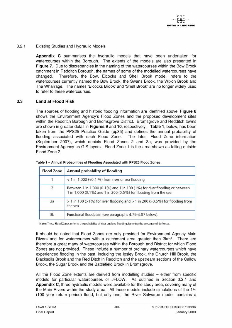
Level 1 SFRA -30- 9T1791/R00003/303671/Birm Final Report January 2009
3.2.1 Existing Studies and Hydraulic Models
Appendix C summarises the hydraulic models that have been undertaken for watercourses within the Borough. The extents of the models are also presented in Figure 7. Due to discrepancies in the naming of the watercourses within the Bow Brook catchment in Redditch Borough, the names of some of the modelled watercourses have changed. Therefore, the Bow, Elcocks and Shell Brook model, refers to the watercourses currently named the Bow Brook, the Swans Brook, the Wixon Brook and The Wharrage. The names ‘Elcocks Brook’ and ‘Shell Brook’ are no longer widely used to refer to these watercourses.
3.3 Land at Flood Risk
The sources of flooding and historic flooding information are identified above. Figure 8 shows the Environment Agency’s Flood Zones and the proposed development sites within the Redditch Borough and Bromsgrove District. Bromsgrove and Redditch towns are shown in greater detail in Figures 9 and 10, respectively. Table 1, below, has been taken from the PPS25 Practice Guide (pp35) and defines the annual probability of flooding associated with each Flood Zone. The latest Flood Zone information (September 2007), which depicts Flood Zones 2 and 3a, was provided by the Environment Agency as GIS layers. Flood Zone 1 is the area shown as falling outside Flood Zone 2. Table 1 – Annual Probabilities of Flooding Associated with PPS25 Flood Zones
It should be noted that Flood Zones are only provided for Environment Agency Main Rivers and for watercourses with a catchment area greater than 3km². There are therefore a great many of watercourses within the Borough and District for which Flood Zones are not provided. These include a number of ordinary watercourses which have experienced flooding in the past, including the Ipsley Brook, the Church Hill Brook, the Blacksoils Brook and the Red Ditch in Redditch and the upstream sections of the Callow Brook, the Sugar Brook and the Battlefield Brook in Bromsgrove. All the Flood Zone extents are derived from modelling studies – either from specific models for particular watercourses or JFLOW. As outlined in Section 3.2.1 and Appendix C, three hydraulic models were available for the study area, covering many of the Main Rivers within the study area. All these models include simulations of the 1% (100 year return period) flood, but only one, the River Salwarpe model, contains a
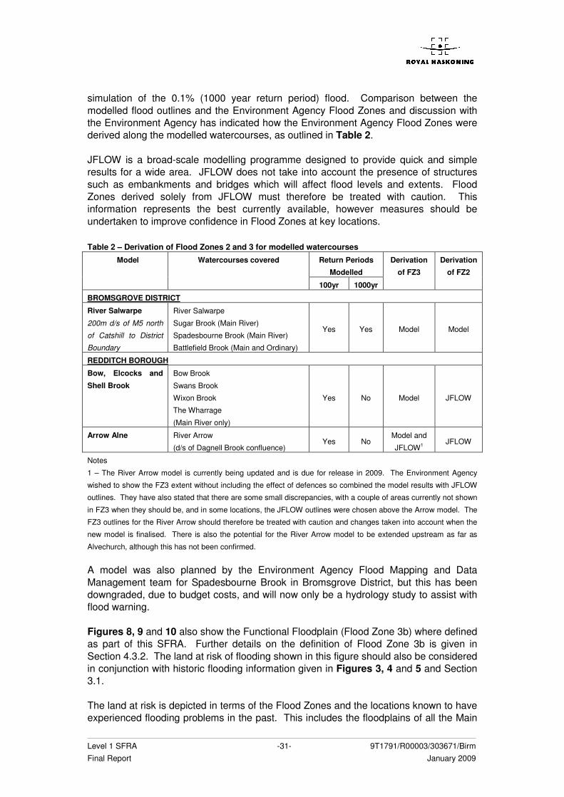
Level 1 SFRA -31- 9T1791/R00003/303671/Birm Final Report January 2009
simulation of the 0.1% (1000 year return period) flood. Comparison between the modelled flood outlines and the Environment Agency Flood Zones and discussion with the Environment Agency has indicated how the Environment Agency Flood Zones were derived along the modelled watercourses, as outlined in Table 2. JFLOW is a broad-scale modelling programme designed to provide quick and simple results for a wide area. JFLOW does not take into account the presence of structures such as embankments and bridges which will affect flood levels and extents. Flood Zones derived solely from JFLOW must therefore be treated with caution. This information represents the best currently available, however measures should be undertaken to improve confidence in Flood Zones at key locations. Table 2 – Derivation of Flood Zones 2 and 3 for modelled watercourses
Return Periods
Modelled
Model Watercourses covered
100yr 1000yr
Derivation
of FZ3
Derivation
of FZ2
BROMSGROVE DISTRICT
River Salwarpe
200m d/s of M5 north
of Catshill to District
Boundary
River Salwarpe
Sugar Brook (Main River)
Spadesbourne Brook (Main River)
Battlefield Brook (Main and Ordinary)
Yes Yes Model Model
REDDITCH BOROUGH
Bow, Elcocks and
Shell Brook
Bow Brook
Swans Brook
Wixon Brook
The Wharrage
(Main River only)
Yes No Model JFLOW
Arrow Alne River Arrow
(d/s of Dagnell Brook confluence) Yes No
Model and
JFLOW1 JFLOW
Notes
1 – The River Arrow model is currently being updated and is due for release in 2009. The Environment Agency
wished to show the FZ3 extent without including the effect of defences so combined the model results with JFLOW
outlines. They have also stated that there are some small discrepancies, with a couple of areas currently not shown
in FZ3 when they should be, and in some locations, the JFLOW outlines were chosen above the Arrow model. The
FZ3 outlines for the River Arrow should therefore be treated with caution and changes taken into account when the
new model is finalised. There is also the potential for the River Arrow model to be extended upstream as far as
Alvechurch, although this has not been confirmed. A model was also planned by the Environment Agency Flood Mapping and Data Management team for Spadesbourne Brook in Bromsgrove District, but this has been downgraded, due to budget costs, and will now only be a hydrology study to assist with flood warning. Figures 8, 9 and 10 also show the Functional Floodplain (Flood Zone 3b) where defined as part of this SFRA. Further details on the definition of Flood Zone 3b is given in Section 4.3.2. The land at risk of flooding shown in this figure should also be considered in conjunction with historic flooding information given in Figures 3, 4 and 5 and Section 3.1. The land at risk is depicted in terms of the Flood Zones and the locations known to have experienced flooding problems in the past. This includes the floodplains of all the Main

Level 1 SFRA -32- 9T1791/R00003/303671/Birm Final Report January 2009
Rivers present within the Borough and District in addition to the floodplains of many of the ordinary watercourses. Table D.1 and Table D.2 of PPS25 define the Environment Agency’s Flood Zones and provide flood risk vulnerability classification, including policy aims and Flood Risk Assessment (FRA) requirements.
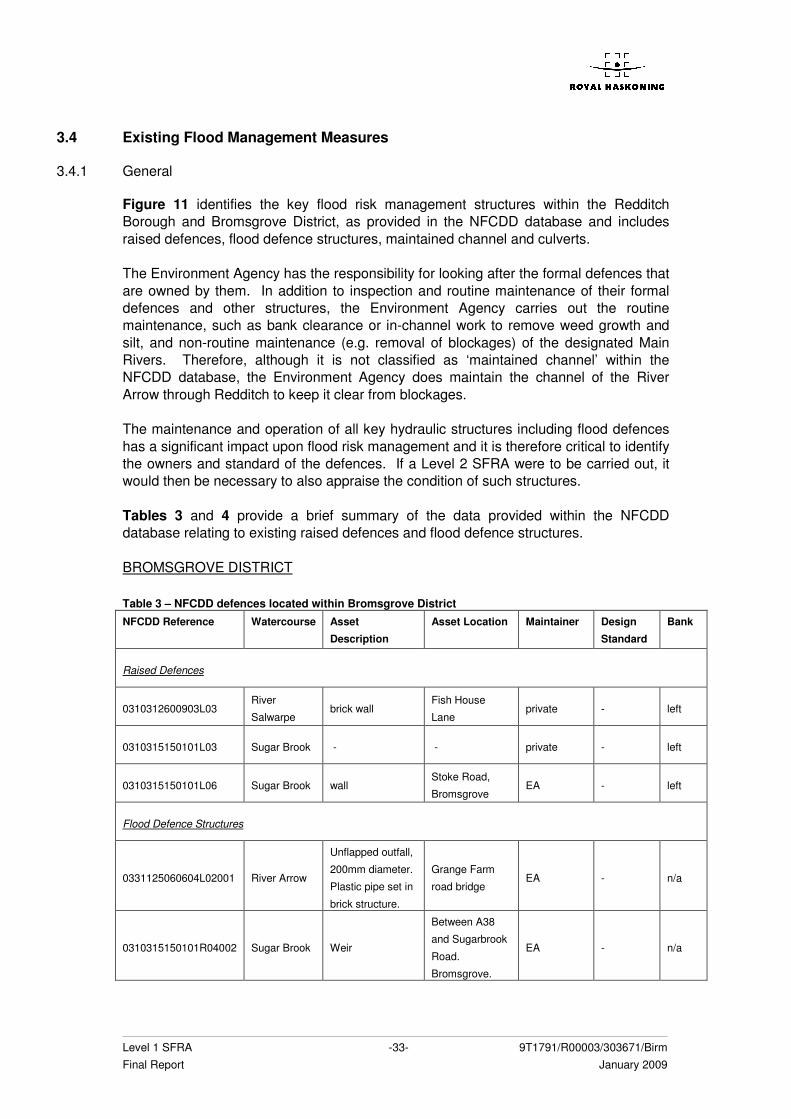
Level 1 SFRA -33- 9T1791/R00003/303671/Birm Final Report January 2009
3.4 Existing Flood Management Measures
3.4.1 General
Figure 11 identifies the key flood risk management structures within the Redditch Borough and Bromsgrove District, as provided in the NFCDD database and includes raised defences, flood defence structures, maintained channel and culverts. The Environment Agency has the responsibility for looking after the formal defences that are owned by them. In addition to inspection and routine maintenance of their formal defences and other structures, the Environment Agency carries out the routine maintenance, such as bank clearance or in-channel work to remove weed growth and silt, and non-routine maintenance (e.g. removal of blockages) of the designated Main Rivers. Therefore, although it is not classified as ‘maintained channel’ within the NFCDD database, the Environment Agency does maintain the channel of the River Arrow through Redditch to keep it clear from blockages. The maintenance and operation of all key hydraulic structures including flood defences has a significant impact upon flood risk management and it is therefore critical to identify the owners and standard of the defences. If a Level 2 SFRA were to be carried out, it would then be necessary to also appraise the condition of such structures. Tables 3 and 4 provide a brief summary of the data provided within the NFCDD database relating to existing raised defences and flood defence structures. BROMSGROVE DISTRICT Table 3 – NFCDD defences located within Bromsgrove District
NFCDD Reference Watercourse Asset
Description
Asset Location Maintainer Design
Standard
Bank
Raised Defences
0310312600903L03 River
Salwarpe brick wall
Fish House
Lane private - left
0310315150101L03 Sugar Brook - - private - left
0310315150101L06 Sugar Brook wall Stoke Road,
Bromsgrove EA - left
Flood Defence Structures
0331125060604L02001 River Arrow
Unflapped outfall,
200mm diameter.
Plastic pipe set in
brick structure.
Grange Farm
road bridge
EA - n/a
0310315150101R04002 Sugar Brook Weir
Between A38
and Sugarbrook
Road.
Bromsgrove.
EA - n/a
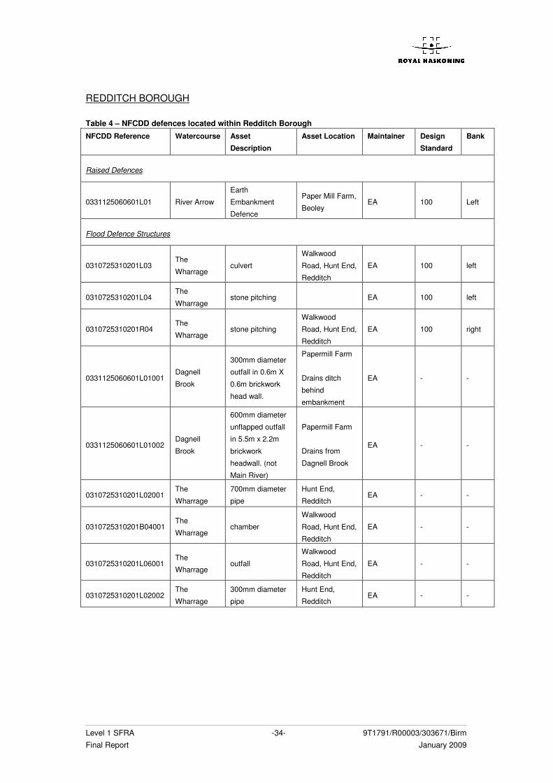
Level 1 SFRA -34- 9T1791/R00003/303671/Birm Final Report January 2009
REDDITCH BOROUGH Table 4 – NFCDD defences located within Redditch Borough NFCDD Reference Watercourse Asset
Description
Asset Location Maintainer Design
Standard
Bank
Raised Defences
0331125060601L01 River Arrow
Earth
Embankment
Defence
Paper Mill Farm,
Beoley EA 100 Left
Flood Defence Structures
0310725310201L03 The
Wharrage culvert
Walkwood
Road, Hunt End,
Redditch
EA 100 left
0310725310201L04 The
Wharrage stone pitching EA 100 left
0310725310201R04 The
Wharrage stone pitching
Walkwood
Road, Hunt End,
Redditch
EA 100 right
0331125060601L01001 Dagnell
Brook
300mm diameter
outfall in 0.6m X
0.6m brickwork
head wall.
Papermill Farm
Drains ditch
behind
embankment
EA - -
0331125060601L01002 Dagnell
Brook
600mm diameter
unflapped outfall
in 5.5m x 2.2m
brickwork
headwall. (not
Main River)
Papermill Farm
Drains from
Dagnell Brook
EA - -
0310725310201L02001 The
Wharrage
700mm diameter
pipe
Hunt End,
Redditch EA - -
0310725310201B04001 The
Wharrage chamber
Walkwood
Road, Hunt End,
Redditch
EA - -
0310725310201L06001 The
Wharrage outfall
Walkwood
Road, Hunt End,
Redditch
EA - -
0310725310201L02002 The
Wharrage
300mm diameter
pipe
Hunt End,
Redditch EA - -
Level 1 SFRA -35- 9T1791/R00003/303671/Birm Final Report January 2009
3.5 Flood Warning and Emergency Response
3.5.1 Flood Warning
Across the whole of England, the responsibility for flood warning rests primarily with the Environment Agency. It provides flood warnings for designated Flood Warning Areas that are based on risk categories, which take into account factors such as the likelihood and impact of flooding, and the resulting risk for each area. The Environment Agency has supplied the details of present flood warning arrangements for Bromsgrove District and Redditch Borough and it appears that none of the watercourses within this study are covered by the warnings, with the Flood Warning area for the River Arrow terminating just downstream of the Redditch Borough boundary. However, the Environment Agency continuously updates its flood warning system and therefore the relevant Agency Area staff should be contacted for the latest information. The location of Flood Warning areas can also be obtained from the Environment Agency’s online maps, available at the following website: www.environment-agency.gov.uk/maps/info/fwa/ The Environment Agency also provides a Flood Watch service which gives a general early alert to possible flooding. Figure 11 shows the areas covered by the flood watch service. BROMSGROVE DISTRICT The Flood Watch service within Bromsgrove District includes most of the area lying within the boundary of Flood Zones 2 and 3 along the following watercourses:
• River Salwarpe (entire extent through Bromsgrove District) • Sugar Brook (where it is enmained, plus its unnamed tributary flowing parallel to
the railway line, with the upstream extent of St Godwald’s Road) • Spadesbourne Brook (upstream extent just north of Lickey End) • Battlefield Brook (upstream extent is Silvadale, Wildmoor) • Hen Brook (upstream extent is Orchard Farm) • Unnamed ordinary watercourse west of Bromsgrove (upstream extent is
Dodford) • Hockley Brook (upstream extent of Dordale Road) • River Arrow (upstream extent is Lower Bittell Reservoir) • Batchley Brook (very short stretch slightly upstream of Redditch Borough
boundary) • Dagnell Brook (very short stretch slightly upstream of Redditch Borough
boundary) For most of these watercourses, the Flood Watch outline matches Flood Zone 2. However, the Flood Watch outlines for the River Arrow, the Dagnell Brook and the Batchley Brook do not match the Flood Zones.
Level 1 SFRA -36- 9T1791/R00003/303671/Birm Final Report January 2009
REDDITCH BOROUGH The Flood Watch service within Redditch District includes the following watercourses:
• River Arrow (entire extent through Borough) • Dagnell Brook (entire extent through Borough) • Batchley Brook (entire extent through Borough)
3.5.2 Warning Dissemination
Flood Warnings are disseminated by the Environment Agency via a system known as Floodline Warnings Direct. The service is a free flood warning service that provides warnings direct to customers 24 hours a day by telephone, mobile, fax or pager. It replaces the older Automatic Voice Messaging System which was used to send out flood warnings direct to the public since 1996. The message details the level of warning issued for the area for which the warning is in force and advice on what action to take. As flood events develop the public is encouraged to phone Floodline for updates. This system requires residents of “at risk property” to register their telephone numbers with the Environment Agency. Concerned parties are able to obtain current flood warning information according to a particular river or Flood Warning Risk Area. The Floodline dial-up service is also available for the Flood Watch Areas. The usual Floodline number is dialled 0845 9881188 and the appropriate prompts followed. Quick Dial numbers are also now being introduced to speed up the dissemination of data. Every Flood Warning or Flood Watch area is given a unique six or seven digit code which can be entered when prompted to bypass the rest of the choice menus. Callers are then given the option to listen recorded flood warning information 24 hours a day or speak to a trained operator for more advice. Any advice given for a Flood Watch Area will be general. Other current methods of warning dissemination include: • The media – warnings are issued through the media; they are broadcast on TV
weather bulletins and on radio weather and travel reports. Flood warnings are also displayed on ITV Teletext regional weather pages (page 154) and on the BBC Ceefax (page 419).
• Internet – The Environment Agency’s website www.environment-agency.gov.uk/flood contains live warning information.
If the Flood Warning areas extend into the Borough or District, anyone who is at risk of flooding should consider contacting the Environment Agency. The Environment Agency issues flood warnings using a set of four easily recognisable codes which include: • Flood Watch, where flooding of low-lying land and roads is possible; • Flood Warning, where flooding of homes, businesses and main roads is expected; • Severe Flood Warning, where severe flooding is expected. Extreme danger to life
and property; and • All Clear, where flood watches or warnings are no longer in force.
Level 1 SFRA -37- 9T1791/R00003/303671/Birm Final Report January 2009
A Flood Watch would be issued when water levels along the river are forecast to cause out-of-bank flooding of low-lying land and roads. A Flood Warning is issued when the Environment Agency anticipate flooding to property. The trigger levels currently set for this are based on the levels of permanent dwellings. The trigger for issue of a Severe Flood Warning is dependent on a number of factors, but is essentially used when there is thought to be extreme danger to life. The Environment Agency generally aims to give a two-hour lead time for all of the above levels of warning prior to any properties being flooded. However in certain cases of severe or “flash flooding” this may not always be possible. The Environment Agency can not provide flood warnings for surface water, road drains, sewer flooding and burst drains. The information on these will come from the Highways Agency, Council, Severn Trent Water and the public. Certain areas may be at additional risk due to their location downstream of heavily urbanised areas and urban areas that have the potential for “flash flooding”, surcharging the capacity of existing sewers and watercourses.
3.5.3 Emergency Response
Neither of the Councils have produced Emergency Flood Plans of their own, both being included within the Worcestershire County Emergency Flood Plan2, re-issued in September 2005. However, this has not been updated since September 2005. No other local Flood Action Plans have been obtained.
3.6 Land Management
Flood risk is not only influenced by the volume of rainfall and the capacity of the watercourses, but also by the flood propagation in the floodplain and the rate and speed of land runoff within the catchment. The awareness of the link between rural land use and land management and flood generation has risen in recent years following the major flood events in the UK and Europe. Although the general intensity of farming practices has increased over the last 50 years, the impacts of these practices in terms of runoff generation at the catchment scale have been difficult to quantify. A number of projects have been undertaken to explore specific land use of land management effects on runoff generation at a variety of scales, including the Defra/EA R&D Project FD2114. This review found that although there as substantial evidence of changes in land use and management practices affecting runoff generation at the local scale, there was very limited evidence that these local changes were transferred to the arterial drainage network and propagated downstream to the larger catchment scale. However, this may mean that the nature of the effect differs between catchments and is usually difficult to detect rather than that there is no catchment scale effect whatsoever. In order to develop new and sustainable approaches for flood and coastal erosion risk management in England, Defra has launched a new cross Government programme entitled ‘Making Space for Water’3. This programme sets out a strategic direction on a number of key issues and outlines a programme of work required to resolve difficult policy issues over the next 20 years. It consists of four key themes, one of which 2 EA ‘High Level Target 3: Emergency Exercises and Emergency Plans’ Report to DEFRA April 2005 3 MSfW homepage: http://www.defra.gov.uk/environ/fcd/policy/strategy.htm
Level 1 SFRA -38- 9T1791/R00003/303671/Birm Final Report January 2009
considers a ‘holistic approach to managing flood and coastal erosion risk’. Under this section of the programme, the Environment Agency has carried out two projects with the purpose to investigate the role that rural land use and land management can play in reducing flood risk at the farm and catchment scale: HA6, Catchment Scale Land-Use Management; and HA7, Land Management Practices (which considers land management at the farm scale). Two reports were released regarding these projects in January 2008, outlining the current position of the Environment Agency with respect to their knowledge on the subject. The ongoing research projects should provide more direct evidence of the catchment scale effects for dissemination to the appropriate stakeholders and policy makers. It is therefore important to assess, and account for, the effect of land management practices upon flood risk. Using the information gained from these publications and discussions with the Council Drainage Engineers, Section 3.6 will discuss the impact of land management practices upon flood risk and the sustainability of current land uses within Bromsgrove District and Redditch Borough.
Level 1 SFRA -39- 9T1791/R00003/303671/Birm Final Report January 2009
4 DEVELOPMENT AND FLOOD RISK ISSUES
4.1 Potential Development Sites
This Level 1 SFRA has been prepared mindful of the current potential development sites, both Brownfield and Greenfield, as provided by the Councils. The locations of potential development sites are presented in Figures 2, 8, 9 and 10. For ease of reference each development site has been given a unique identification number for cross-reference with these figures. Tables 5 and 6 summarise the development shapefiles given and the unique identification numbers used within this report. Table 5 – Proposed Development Sites within Bromsgrove District
GIS Shapefile Proposed Development Sites
Employment Zoning E1 – E8
Employment Policies PR1 – PR5
Residential Policies PR41 – PR43
Residential Zoning PR34 – PR40
Areas of Development Restraint (ADRs) A1 – A13
Green Belt Zoning PR6 – PR19
Unzoned UZ1
Open Space Policies PR2 – PR33
Shopping Regions Sh1 – Sh10
Table 6 – Proposed Development Sites within Redditch Borough
GIS Shapefile Proposed Development Sites
Housing H1 – H13
Employment E9 – E27
ADRs A14 – A16
- Housing St5, St9
- Employment St6, St8
- Unidentified St7 Strategic Sites
- Mixed Use St1 – St4, St10
4.2 PPS25 Requirements
PPS25 is a new-style PPS reflecting the expectations of the Government’s Planning Green Paper, Planning: delivering a fundamental change. It focuses on national policy and provides clarity on what is required at regional and local levels to ensure that decisions are made at the most appropriate level and in a timely fashion to deliver sustainable planning for development and flood risk. Section 3.47 of Development and Flood Risk a Practice Guide Companion to PPS25, states the key outputs from a Level 1 SFRA to be as follows:
• Plans showing the LPA area, Main Rivers, ordinary watercourses and flood zones, including the functional floodplain if appropriate (as defined in annex D table D.1 of PPS25), across the local authority area as well as all previously allocated development sites (or sites to be considered in the future);
Level 1 SFRA -40- 9T1791/R00003/303671/Birm Final Report January 2009
• An assessment of the implications of climate change for flood risk at allocated development sites over an appropriate time period, if this has not been factored into the plans above.
• Areas at risk from other sources of flooding such as surface water and groundwater flooding (N.B. the Environment Agency Flood Map only shows rivers and tidal flood risk);
• The location of any flood risk management measures, including standard of infrastructure and the coverage of flood warning systems.
• Locations where additional development may significantly increase flood risk elsewhere through the impact on existing sources of flooding, or by the generation of increased surface water run-off;
• Guidance on the preparation of FRAs for allocated development sites; and • Guidance on the likely applicability of different sustainable drainage systems
(SUDS) techniques for managing surface water run-off at key development sites.
(Development and Flood Risk: A Practice Guide, Communities and Local Government, June 2008) The remainder of Section 4 highlights how these outputs have been addressed in the production of this Level 1 SFRA.
4.3 Mapping, Flood Zones and Development Areas
Plans showing the LPA area, Main Rivers, ordinary watercourses and flood zones, including the functional floodplain if appropriate (as defined in annex D table D.1 of PPS25), across the local authority area as well as all previously allocated development sites (or sites to be considered in the future)
4.3.1 General
Figure 1 of this report shows the Bromsgrove District and Redditch Borough boundaries, the Main Rivers and ordinary watercourses. The Environment Agency’s Flood Zones 2 and 3a (1000 and 100 year return periods respectively) are presented in Figures 8, 9 and 10, along with the current potential development sites. The derivation of these Flood Zones is explained in Section 3.3 and Table 1.
4.3.2 Functional Floodplain
As defined in PPS25, the Functional Floodplain (i.e. Zone 3b) comprises land where water has to flow or be stored in times of flood. It includes the land which would flood with an annual probability of 1 in 20 (5%) or greater in any year or is designed to flood in an extreme (0.1%) flood, or at another probability to be agreed between the LPA and the Environment Agency, including planned water conveyance routes. This zone takes into account the effect of existing flood risk management measures and other infrastructure in accordance with the guidance given in the Practice Guide. Functional Floodplain has been determined for all watercourses for which modelled flood outlines or levels are currently available. Functional Floodplain is also presented in Figures 8, 9 and 10. It should be noted that only three of the watercourses within the Borough and District have been modelled and, for these, flood levels and outlines were
Level 1 SFRA -41- 9T1791/R00003/303671/Birm Final Report January 2009
not available at the 1 in 20 (5%) return period. However, the 1 in 25 (4%) outlines were provided for each of these models and have therefore been used as a conservative approximation to indicate the extent of the Functional Floodplain for the following watercourses: BROMSGROVE DISTRICT
• the River Salwarpe (including the enmained stretches of the Sugar Brook and the Spadesbourne Brook and the Battlefield Brook with the upstream extent of the modelled outlines located 200m downstream of the M5 north of Catshill);
REDDITCH BOROUGH
• the River Arrow (upstream extent is north of Arrow valley park, SP052507); and • the Bow Brook, the Swans Brook, the Wixon Brook and the Wharrage (upstream
extent of Sillins Lane on the Swans Brook and Swinbourne Road on The Wharrage).
Therefore the Functional Floodplain has been based on the results of the 25 year return period models where available. Further details describing the current availability of hydraulic modelling within the Borough and District is given in Appendix C of this report. However, as described in Section 3.3, it must be noted that the River Arrow model is currently being updated, which may alter the extents of all the Flood Zones, including the 25 year outline. It must also be noted that the Flood Zone 3 outline for the River Arrow was determined using a combination of the model outputs and JFLOW modelling. As a result the Flood Zone 3 extent is, in some locations through Redditch, more extensive than the model outline would suggest. This may also apply to the 25 year model outlines so the extent of the Functional Floodplain should be reviewed with caution and will require updating once the new River Arrow model is completed. Additional hydraulic modelling is beyond the scope of the Level 1 SFRA and therefore the Functional Floodplain has still to be identified for the many other watercourses, which have development sites in close proximity, either as part of a future Level 2 SFRA or a site specific FRA: BROMSGROVE DISTRICT
• Hen Brook; • Sugar Brook (where it is classified as ordinary watercourse); • Spadesbourne Brook (where it is classified as ordinary watercourse); • Minor tributaries of the Sugar Brook, flowing through Finstall, Aston Fields and
Tardebigge; • Eastern branch of the Battlefield Brook through Upper and Lower Marlbrook and
Catshill; • Callow Brook; • Hoo Brook; • Gallows Brook; • Churchill Brook (upstream section); • Blacksoils Brook (upstream section); • River Cole; and • Other, minor, unnamed tributaries of the ordinary watercourses listed above
where they border or intersect proposed development sites.
Level 1 SFRA -42- 9T1791/R00003/303671/Birm Final Report January 2009
REDDITCH BOROUGH
• Batchely Brook; • Red Ditch; • Churchill Brook; • Blacksoils Brook; • Ipsley Brook; • Wharrington Brook; • Bordesley Brook; • Plack Brook; and • Other, minor, unnamed tributaries of the ordinary watercourses listed above
where they border or intersect proposed development sites. Until a Level 2 SFRA has been produced or appropriate site specific FRAs show this zone for the above watercourses to the satisfaction of the Environment Agency, it is recommended that all areas within the Flood Zone 3a, where available, should be considered as the Functional Floodplain.
4.3.3 Assessment of Fluvial Flood Risk to Proposed Development Areas
Tables 7a – 7f and 8a – 8d indicate the details of the potential development sites within the Borough and District and whether they are located within Flood Zones 2 and 3. All planning applications for development proposals of 1 hectare or greater in Flood Zone 1 and all proposals for new development located in Flood Zones 2 and 3 should be accompanied by a FRA to satisfy the requirements of PPS25. These sites will also need to be sequentially tested, especially those which are in a flood risk area, with sites of a lesser risk being potentially considered. Sites within these tables which are allocated for development and contain significant parts of the site within a flood risk area will require further work in a Level 2 SFRA in order to demonstrate that the sites can be developed without increasing flood risk, preferably reducing it, and that the developments are safe. Some of the sites, such as A3, A4 and A5, have watercourses running through them that have not been included within the Environment Agency’s Flood Zone Mapping (due to their catchment areas being smaller than 3km²) or been modeled independently. These sites will therefore require further analysis within site specific FRAs or a Level 2 SFRA to gain a more detailed understanding of the floor risk within these locations. .
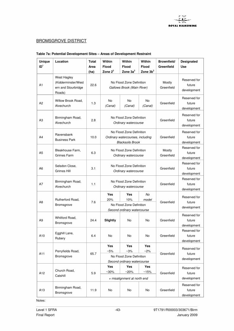
Level 1 SFRA -43- 9T1791/R00003/303671/Birm Final Report January 2009
BROMSGROVE DISTRICT
Table 7a: Potential Development Sites – Areas of Development Restraint
Unique
ID1
Location Total
Area
(ha)
Within
Flood
Zone 22
Within
Flood
Zone 3a2
Within
Flood
Zone 3b2
Brownfield/
Greenfield
Designated
Use
A1
West Hagley
(Kidderminster/West
ern and Stourbridge
Roads)
22.6 No Flood Zone Definition
Gallows Brook (Main River)
Mostly
Greenfield
Reserved for
future
development
A2 Willow Brook Road,
Alvechurch 1.3
No
(Canal)
No
(Canal)
No
(Canal) Greenfield
Reserved for
future
development
A3 Birmingham Road,
Alvechurch 2.8
No Flood Zone Definition
Ordinary watercourse Greenfield
Reserved for
future
development
A4 Ravensbank
Business Park 10.0
No Flood Zone Definition
Ordinary watercourses, including
Blacksoils Brook
Greenfield
Reserved for
future
development
A5 Bleakhouse Farm,
Grimes Farm 6.3
No Flood Zone Definition
Ordinary watercourse
Mostly
Greenfield
Reserved for
future
development
A6 Selsdon Close,
Grimes Hill 3.1
No Flood Zone Definition
Ordinary watercourse Greenfield
Reserved for
future
development
A7 Birmingham Road,
Alvechurch 1.1
No Flood Zone Definition
Ordinary watercourse Greenfield
Reserved for
future
development
Yes
20%
Yes
10%
No
model A8
Rutherford Road,
Bromsgrove 7.6
No Flood Zone Definition
Second ordinary watercourse
Greenfield
Reserved for
future
development
A9 Whitford Road,
Bromsgrove 24.4 Slightly No No Greenfield
Reserved for
future
development
A10 Egghill Lane,
Rubery 6.4 No No No Greenfield
Reserved for
future
development
Yes
~5%
Yes
~3%
Yes
~2% A11
Perryfields Road,
Bromsgrove 65.7
No Flood Zone Definition
Second ordinary watercourse
Greenfield
Reserved for
future
development
Yes
~30%
Yes
~20%
Yes
~15% A12 Church Road,
Catshill 5.9
+ misalignment at north end
Greenfield
Reserved for
future
development
A13 Birmingham Road,
Bromsgrove 11.9 No No No Greenfield
Reserved for
future
development
Notes:
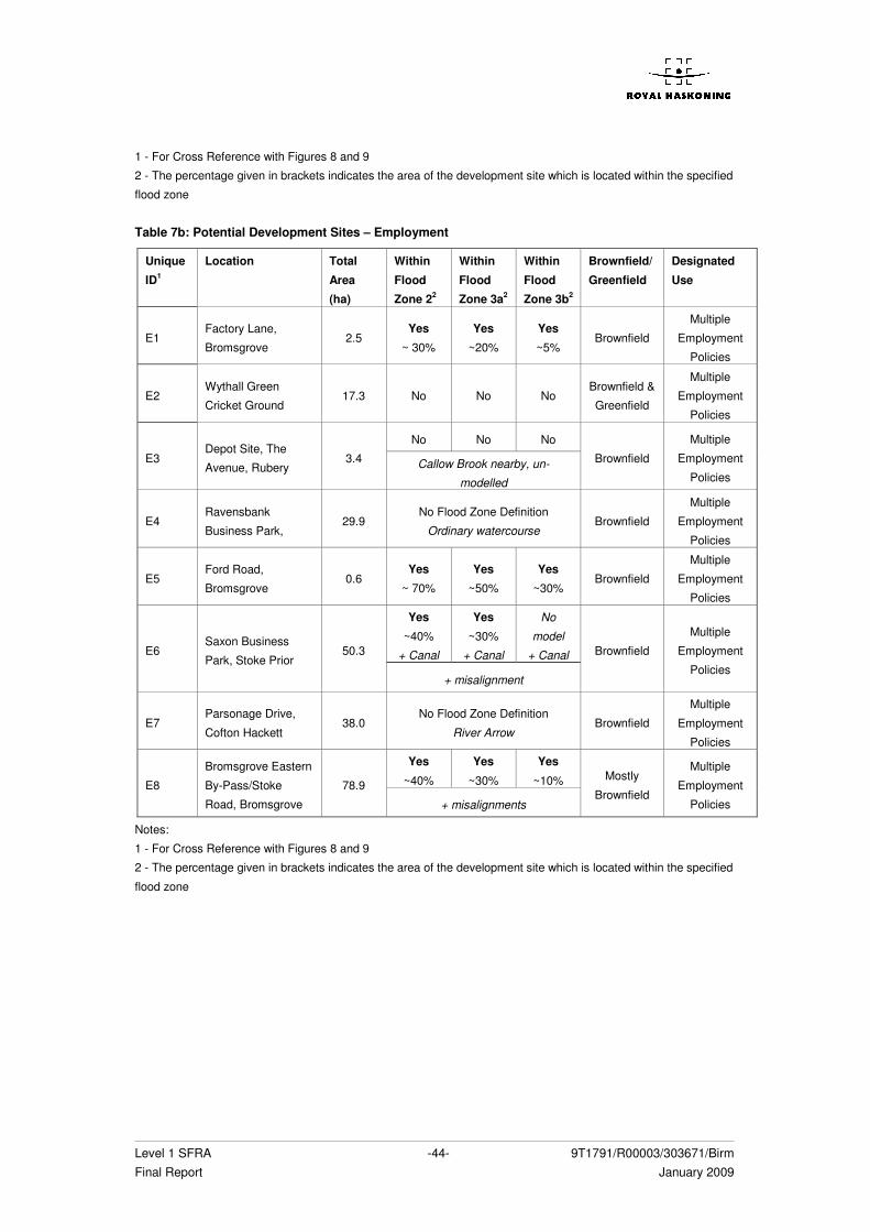
Level 1 SFRA -44- 9T1791/R00003/303671/Birm Final Report January 2009
1 - For Cross Reference with Figures 8 and 9
2 - The percentage given in brackets indicates the area of the development site which is located within the specified
flood zone
Table 7b: Potential Development Sites – Employment
Unique
ID1
Location Total
Area
(ha)
Within
Flood
Zone 22
Within
Flood
Zone 3a2
Within
Flood
Zone 3b2
Brownfield/
Greenfield
Designated
Use
E1 Factory Lane,
Bromsgrove 2.5
Yes
~ 30%
Yes
~20%
Yes
~5% Brownfield
Multiple
Employment
Policies
E2 Wythall Green
Cricket Ground 17.3 No No No
Brownfield &
Greenfield
Multiple
Employment
Policies
No No No
E3 Depot Site, The
Avenue, Rubery 3.4 Callow Brook nearby, un-
modelled
Brownfield
Multiple
Employment
Policies
E4 Ravensbank
Business Park, 29.9
No Flood Zone Definition
Ordinary watercourse Brownfield
Multiple
Employment
Policies
E5 Ford Road,
Bromsgrove 0.6
Yes
~ 70%
Yes
~50%
Yes
~30% Brownfield
Multiple
Employment
Policies
Yes
~40%
+ Canal
Yes
~30%
+ Canal
No
model
+ Canal E6 Saxon Business
Park, Stoke Prior 50.3
+ misalignment
Brownfield
Multiple
Employment
Policies
E7 Parsonage Drive,
Cofton Hackett 38.0
No Flood Zone Definition
River Arrow Brownfield
Multiple
Employment
Policies
Yes
~40%
Yes
~30%
Yes
~10% E8
Bromsgrove Eastern
By-Pass/Stoke
Road, Bromsgrove
78.9
+ misalignments
Mostly
Brownfield
Multiple
Employment
Policies
Notes:
1 - For Cross Reference with Figures 8 and 9
2 - The percentage given in brackets indicates the area of the development site which is located within the specified
flood zone
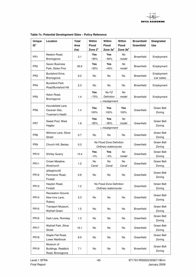
Level 1 SFRA -45- 9T1791/R00003/303671/Birm Final Report January 2009
Table 7c: Potential Development Sites – Policy Reference
Unique
ID1
Location Total
Area
(ha)
Within
Flood
Zone 22
Within
Flood
Zone 3a2
Within
Flood
Zone 3b2
Brownfield/
Greenfield
Designated
Use
PR1 Newton Road,
Bromsgrove 3.1
Yes
~95%
Yes
~90%
No
model Brownfield Employment
PR2 Saxon Business
Park, Stoke Prior 26.6
Yes
~50%
Yes
~45%
No
model Brownfield Employment
PR3 Buntsford Drive,
Bromsgrove 9.2 No No No Brownfield
Employment
(car sales)
PR4 Bunstford Park
Road/Buntsford Hill 2.3 No No No Brownfield Employment
Yes
~70%
No FZ
Definition
No
model PR5 Aston Road,
Bromsgrove 1.4
+ misalignment
Brownfield Employment
PR6
Houndsfield Lane
Caravan Site,
Trueman’s Heath
1.4 Yes
100%
Yes
100%
Yes
100% Greenfield
Green Belt
Zoning
Yes
~95%
Yes
~90%
No
model PR7 Sweet Pool, West
Hagley 1.8
+ misalignment
Greenfield Green Belt
Zoning
PR8 Wilmore Lane, Silver
Street 0.7 No No No Greenfield
Green Belt
Zoning
PR9 Church Hill, Beoley 0.3 No Flood Zone Definition
Ordinary watercourse Greenfield
Green Belt
Zoning
PR10 Shirley Quarry 13.4 Yes
~4%
Yes
~2%
No
model Greenfield
Green Belt
Zoning
PR11 Crown Meadow,
Alvechurch 1.2
No
Canal
No
Canal
No
Canal Greenfield
Green Belt
Zoning
PR12
(playground)
Penmanor Road,
Finstall
0.8 No No No Greenfield Green Belt
Zoning
PR13 Heydon Road,
Finstall 1.2
No Flood Zone Definition
Ordinary watercourse Greenfield
Green Belt
Zoning
PR14
Recreation Ground,
New Inns Lane,
Rubery
3.3 No No No Greenfield Green Belt
Zoning
PR15 Transport Museum,
Wythall Green 1.5 No No No Brownfield
Green Belt
Zoning
PR16 Dark Lane, Romsley 1.3 No No No Greenfield Green Belt
Zoning
PR17 Wythall Park, Silver
Street 16.1 No No No Greenfield
Green Belt
Zoning
PR18 Staple Flat Road,
Lower Marlbrook 8.9 No No No Greenfield
Green Belt
Zoning
PR19
Museum of
Buildings, Redditch
Road, Bromsgrove
7.1 No No No Brownfield Green Belt
Zoning
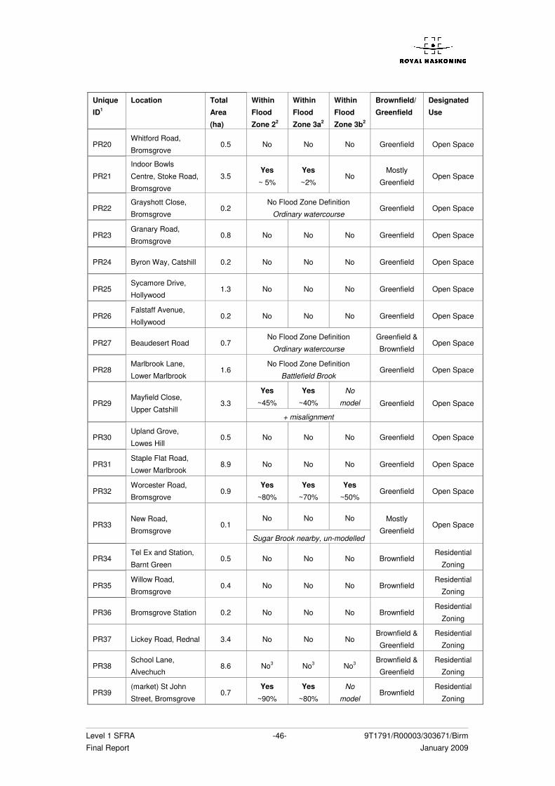
Level 1 SFRA -46- 9T1791/R00003/303671/Birm Final Report January 2009
Unique
ID1
Location Total
Area
(ha)
Within
Flood
Zone 22
Within
Flood
Zone 3a2
Within
Flood
Zone 3b2
Brownfield/
Greenfield
Designated
Use
PR20 Whitford Road,
Bromsgrove 0.5 No No No Greenfield Open Space
PR21
Indoor Bowls
Centre, Stoke Road,
Bromsgrove
3.5 Yes
~ 5%
Yes
~2% No
Mostly
Greenfield Open Space
PR22 Grayshott Close,
Bromsgrove 0.2
No Flood Zone Definition
Ordinary watercourse Greenfield Open Space
PR23 Granary Road,
Bromsgrove 0.8 No No No Greenfield Open Space
PR24 Byron Way, Catshill 0.2 No No No Greenfield Open Space
PR25 Sycamore Drive,
Hollywood 1.3 No No No Greenfield Open Space
PR26 Falstaff Avenue,
Hollywood 0.2 No No No Greenfield Open Space
PR27 Beaudesert Road 0.7 No Flood Zone Definition
Ordinary watercourse
Greenfield &
Brownfield Open Space
PR28 Marlbrook Lane,
Lower Marlbrook 1.6
No Flood Zone Definition
Battlefield Brook Greenfield Open Space
Yes
~45%
Yes
~40%
No
model PR29 Mayfield Close,
Upper Catshill 3.3
+ misalignment
Greenfield Open Space
PR30 Upland Grove,
Lowes Hill 0.5 No No No Greenfield Open Space
PR31 Staple Flat Road,
Lower Marlbrook 8.9 No No No Greenfield Open Space
PR32 Worcester Road,
Bromsgrove 0.9
Yes
~80%
Yes
~70%
Yes
~50% Greenfield Open Space
No No No PR33
New Road,
Bromsgrove 0.1
Sugar Brook nearby, un-modelled
Mostly
Greenfield Open Space
PR34 Tel Ex and Station,
Barnt Green 0.5 No No No Brownfield
Residential
Zoning
PR35 Willow Road,
Bromsgrove 0.4 No No No Brownfield
Residential
Zoning
PR36 Bromsgrove Station 0.2 No No No Brownfield Residential
Zoning
PR37 Lickey Road, Rednal 3.4 No No No Brownfield &
Greenfield
Residential
Zoning
PR38 School Lane,
Alvechuch 8.6 No3 No3 No3
Brownfield &
Greenfield
Residential
Zoning
PR39 (market) St John
Street, Bromsgrove 0.7
Yes
~90%
Yes
~80%
No
model Brownfield
Residential
Zoning
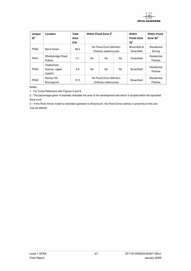
Level 1 SFRA -47- 9T1791/R00003/303671/Birm Final Report January 2009
Unique
ID1
Location Total
Area
(ha)
Within Flood Zone 22 Within
Flood Zone
3a2
Within Flood
Zone 3b2
PR40 Barnt Green 88.4 No Flood Zone Definition
Ordinary watercourses
Brownfield &
Greenfield
Residential
Zoning
PR41 Whettybridge Road,
Rubery 0.1 No No No Greenfield
Residential
Policies
PR42
Cheltenham
Avenue, Upper
Catshill
8.0 No No No Brownfield Residential
Policies
PR43 Stoney Hill,
Bromsgrove 37.5
No Flood Zone Definition
Ordinary watercourse Brownfield
Residential
Policies
Notes:
1 - For Cross Reference with Figures 8 and 9
2 - The percentage given in brackets indicates the area of the development site which is located within the specified
flood zone
3 – If the River Arrow model is extended upstream to Alvechurch, the Flood Zone outlines in proximity to this site
may be altered.
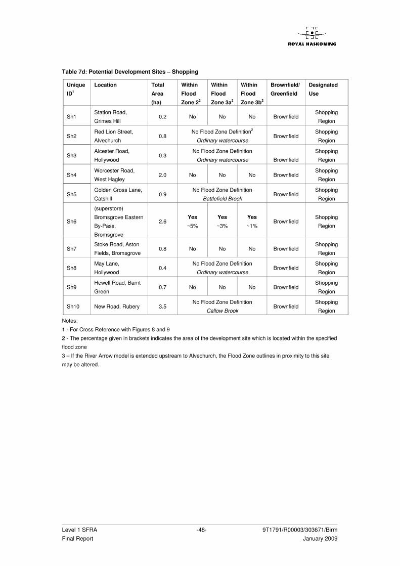
Level 1 SFRA -48- 9T1791/R00003/303671/Birm Final Report January 2009
Table 7d: Potential Development Sites – Shopping
Unique
ID1
Location Total
Area
(ha)
Within
Flood
Zone 22
Within
Flood
Zone 3a2
Within
Flood
Zone 3b2
Brownfield/
Greenfield
Designated
Use
Sh1 Station Road,
Grimes Hill 0.2 No No No Brownfield
Shopping
Region
Sh2 Red Lion Street,
Alvechurch 0.8
No Flood Zone Definition2
Ordinary watercourse Brownfield
Shopping
Region
Sh3 Alcester Road,
Hollywood 0.3
No Flood Zone Definition
Ordinary watercourse
Brownfield
Shopping
Region
Sh4 Worcester Road,
West Hagley 2.0 No No No Brownfield
Shopping
Region
Sh5 Golden Cross Lane,
Catshill 0.9
No Flood Zone Definition
Battlefield Brook Brownfield
Shopping
Region
Sh6
(superstore)
Bromsgrove Eastern
By-Pass,
Bromsgrove
2.6 Yes
~5%
Yes
~3%
Yes
~1% Brownfield
Shopping
Region
Sh7 Stoke Road, Aston
Fields, Bromsgrove 0.8 No No No Brownfield
Shopping
Region
Sh8 May Lane,
Hollywood 0.4
No Flood Zone Definition
Ordinary watercourse Brownfield
Shopping
Region
Sh9 Hewell Road, Barnt
Green 0.7 No No No Brownfield
Shopping
Region
Sh10 New Road, Rubery 3.5 No Flood Zone Definition
Callow Brook Brownfield
Shopping
Region
Notes:
1 - For Cross Reference with Figures 8 and 9
2 - The percentage given in brackets indicates the area of the development site which is located within the specified
flood zone
3 – If the River Arrow model is extended upstream to Alvechurch, the Flood Zone outlines in proximity to this site
may be altered.
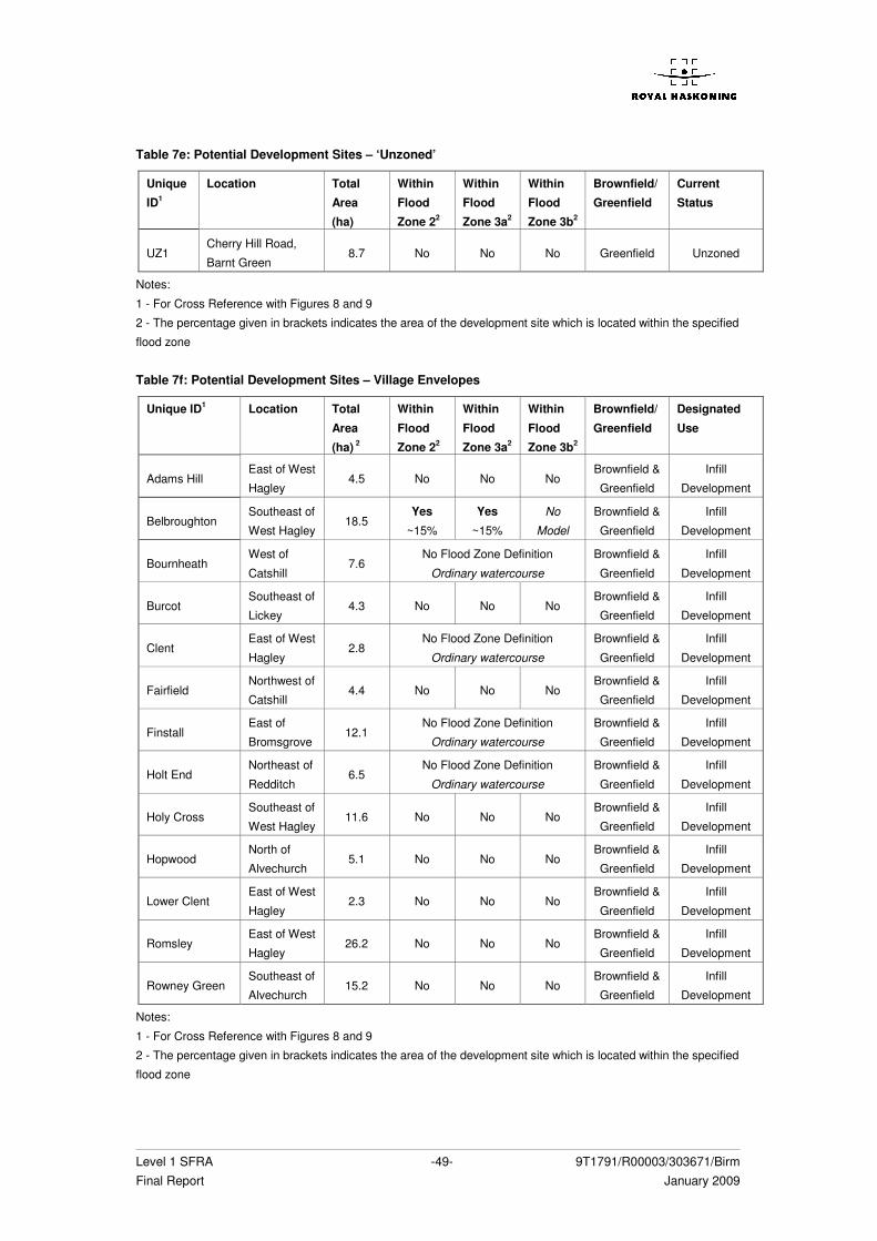
Level 1 SFRA -49- 9T1791/R00003/303671/Birm Final Report January 2009
Table 7e: Potential Development Sites – ‘Unzoned’
Unique
ID1
Location Total
Area
(ha)
Within
Flood
Zone 22
Within
Flood
Zone 3a2
Within
Flood
Zone 3b2
Brownfield/
Greenfield
Current
Status
UZ1 Cherry Hill Road,
Barnt Green 8.7 No No No Greenfield Unzoned
Notes:
1 - For Cross Reference with Figures 8 and 9
2 - The percentage given in brackets indicates the area of the development site which is located within the specified
flood zone
Table 7f: Potential Development Sites – Village Envelopes
Unique ID1 Location Total
Area
(ha) 2
Within
Flood
Zone 22
Within
Flood
Zone 3a2
Within
Flood
Zone 3b2
Brownfield/
Greenfield
Designated
Use
Adams Hill East of West
Hagley 4.5 No No No
Brownfield &
Greenfield
Infill
Development
Belbroughton Southeast of
West Hagley 18.5
Yes
~15%
Yes
~15%
No
Model
Brownfield &
Greenfield
Infill
Development
Bournheath West of
Catshill 7.6
No Flood Zone Definition
Ordinary watercourse
Brownfield &
Greenfield
Infill
Development
Burcot Southeast of
Lickey 4.3 No No No
Brownfield &
Greenfield
Infill
Development
Clent East of West
Hagley 2.8
No Flood Zone Definition
Ordinary watercourse
Brownfield &
Greenfield
Infill
Development
Fairfield Northwest of
Catshill 4.4 No No No
Brownfield &
Greenfield
Infill
Development
Finstall East of
Bromsgrove 12.1
No Flood Zone Definition
Ordinary watercourse
Brownfield &
Greenfield
Infill
Development
Holt End Northeast of
Redditch 6.5
No Flood Zone Definition
Ordinary watercourse
Brownfield &
Greenfield
Infill
Development
Holy Cross Southeast of
West Hagley 11.6 No No No
Brownfield &
Greenfield
Infill
Development
Hopwood North of
Alvechurch 5.1 No No No
Brownfield &
Greenfield
Infill
Development
Lower Clent East of West
Hagley 2.3 No No No
Brownfield &
Greenfield
Infill
Development
Romsley East of West
Hagley 26.2 No No No
Brownfield &
Greenfield
Infill
Development
Rowney Green Southeast of
Alvechurch 15.2 No No No
Brownfield &
Greenfield
Infill
Development
Notes:
1 - For Cross Reference with Figures 8 and 9
2 - The percentage given in brackets indicates the area of the development site which is located within the specified
flood zone
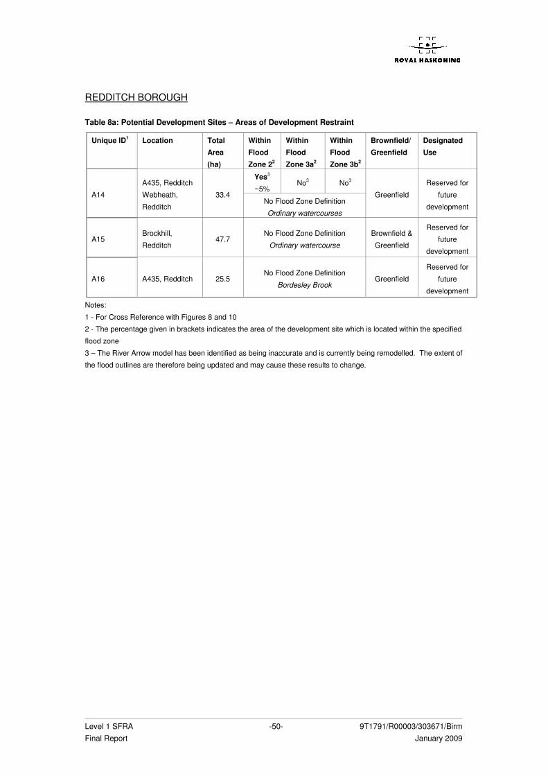
Level 1 SFRA -50- 9T1791/R00003/303671/Birm Final Report January 2009
REDDITCH BOROUGH Table 8a: Potential Development Sites – Areas of Development Restraint
Unique ID1 Location Total
Area
(ha)
Within
Flood
Zone 22
Within
Flood
Zone 3a2
Within
Flood
Zone 3b2
Brownfield/
Greenfield
Designated
Use
Yes3
~5% No3 No3
A14
A435, Redditch
Webheath,
Redditch
33.4 No Flood Zone Definition
Ordinary watercourses
Greenfield
Reserved for
future
development
A15 Brockhill,
Redditch 47.7
No Flood Zone Definition
Ordinary watercourse
Brownfield &
Greenfield
Reserved for
future
development
A16 A435, Redditch 25.5 No Flood Zone Definition
Bordesley Brook Greenfield
Reserved for
future
development
Notes:
1 - For Cross Reference with Figures 8 and 10
2 - The percentage given in brackets indicates the area of the development site which is located within the specified
flood zone
3 – The River Arrow model has been identified as being inaccurate and is currently being remodelled. The extent of
the flood outlines are therefore being updated and may cause these results to change.
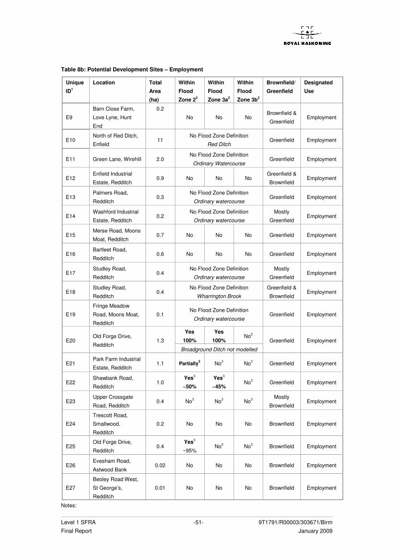
Level 1 SFRA -51- 9T1791/R00003/303671/Birm Final Report January 2009
Table 8b: Potential Development Sites – Employment
Unique
ID1
Location Total
Area
(ha)
Within
Flood
Zone 22
Within
Flood
Zone 3a2
Within
Flood
Zone 3b2
Brownfield/
Greenfield
Designated
Use
E9
Barn Close Farm,
Love Lyne, Hunt
End
0.2
No No No Brownfield &
Greenfield Employment
E10 North of Red Ditch,
Enfield 11
No Flood Zone Definition
Red Ditch Greenfield Employment
E11 Green Lane, Wirehill 2.0 No Flood Zone Definition
Ordinary Watercourse Greenfield Employment
E12 Enfield Industrial
Estate, Redditch 0.9 No No No
Greenfield &
Brownfield Employment
E13 Palmers Road,
Redditch 0.3
No Flood Zone Definition
Ordinary watercourse Greenfield Employment
E14 Washford Industrial
Estate, Redditch 0.2
No Flood Zone Definition
Ordinary watercourse
Mostly
Greenfield Employment
E15 Merse Road, Moons
Moat, Redditch 0.7 No No No Greenfield Employment
E16 Bartleet Road,
Redditch 0.6 No No No Greenfield Employment
E17 Studley Road,
Redditch 0.4
No Flood Zone Definition
Ordinary watercourse
Mostly
Greenfield Employment
E18 Studley Road,
Redditch 0.4
No Flood Zone Definition
Wharrington Brook
Greenfield &
Brownfield Employment
E19
Fringe Meadow
Road, Moons Moat,
Redditch
0.1 No Flood Zone Definition
Ordinary watercourse Greenfield Employment
Yes
100%
Yes
100% No2
E20 Old Forge Drive,
Redditch 1.3
Broadground Ditch not modelled
Greenfield Employment
E21 Park Farm Industrial
Estate, Redditch 1.1 Partially3 No3 No3 Greenfield Employment
E22 Shawbank Road,
Redditch 1.0
Yes3
~50%
Yes3
~45% No3 Greenfield Employment
E23 Upper Crossgate
Road, Redditch 0.4 No3 No3 No3
Mostly
Brownfield Employment
E24
Trescott Road,
Smallwood,
Redditch
0.2 No No No Brownfield Employment
E25 Old Forge Drive,
Redditch 0.4
Yes3
~95% No3 No3 Brownfield Employment
E26 Evesham Road,
Astwood Bank 0.02 No No No Brownfield Employment
E27
Beoley Road West,
St George’s,
Redditch
0.01 No No No Brownfield Employment
Notes:
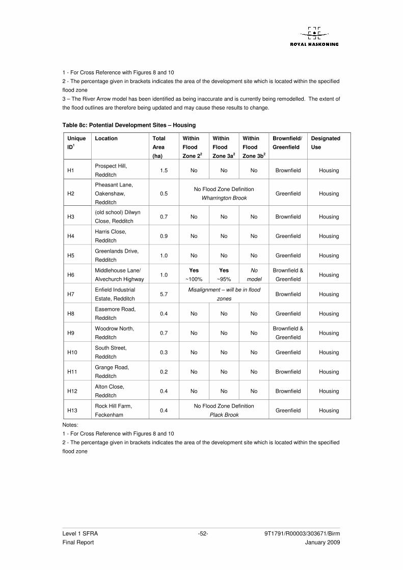
Level 1 SFRA -52- 9T1791/R00003/303671/Birm Final Report January 2009
1 - For Cross Reference with Figures 8 and 10
2 - The percentage given in brackets indicates the area of the development site which is located within the specified
flood zone
3 – The River Arrow model has been identified as being inaccurate and is currently being remodelled. The extent of
the flood outlines are therefore being updated and may cause these results to change. Table 8c: Potential Development Sites – Housing
Unique
ID1
Location Total
Area
(ha)
Within
Flood
Zone 22
Within
Flood
Zone 3a2
Within
Flood
Zone 3b2
Brownfield/
Greenfield
Designated
Use
H1 Prospect Hill,
Redditch 1.5 No No No Brownfield Housing
H2
Pheasant Lane,
Oakenshaw,
Redditch
0.5 No Flood Zone Definition
Wharrington Brook Greenfield Housing
H3 (old school) Dilwyn
Close, Redditch 0.7 No No No Brownfield Housing
H4 Harris Close,
Redditch 0.9 No No No Greenfield Housing
H5 Greenlands Drive,
Redditch 1.0 No No No Greenfield Housing
H6 Middlehouse Lane/
Alvechurch Highway 1.0
Yes
~100%
Yes
~95%
No
model
Brownfield &
Greenfield Housing
H7 Enfield Industrial
Estate, Redditch 5.7
Misalignment – will be in flood
zones Brownfield Housing
H8 Easemore Road,
Redditch 0.4 No No No Greenfield Housing
H9 Woodrow North,
Redditch 0.7 No No No
Brownfield &
Greenfield Housing
H10 South Street,
Redditch 0.3 No No No Greenfield Housing
H11 Grange Road,
Redditch 0.2 No No No Brownfield Housing
H12 Alton Close,
Redditch 0.4 No No No Brownfield Housing
H13 Rock Hill Farm,
Feckenham 0.4
No Flood Zone Definition
Plack Brook Greenfield Housing
Notes:
1 - For Cross Reference with Figures 8 and 10
2 - The percentage given in brackets indicates the area of the development site which is located within the specified
flood zone
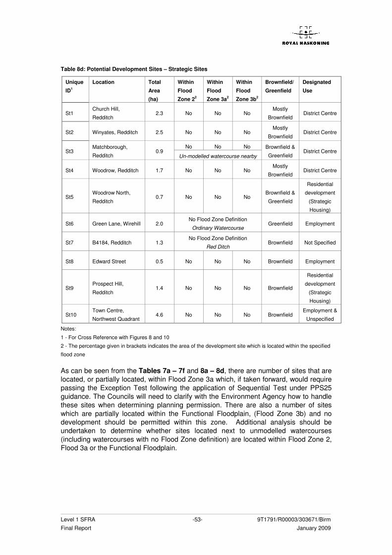
Level 1 SFRA -53- 9T1791/R00003/303671/Birm Final Report January 2009
Table 8d: Potential Development Sites – Strategic Sites
Unique
ID1
Location Total
Area
(ha)
Within
Flood
Zone 22
Within
Flood
Zone 3a2
Within
Flood
Zone 3b2
Brownfield/
Greenfield
Designated
Use
St1 Church Hill,
Redditch 2.3 No No No
Mostly
Brownfield District Centre
St2 Winyates, Redditch 2.5 No No No Mostly
Brownfield District Centre
No No No St3
Matchborough,
Redditch 0.9
Un-modelled watercourse nearby
Brownfield &
Greenfield District Centre
St4 Woodrow, Redditch 1.7 No No No Mostly
Brownfield District Centre
St5 Woodrow North,
Redditch 0.7 No No No
Brownfield &
Greenfield
Residential
development
(Strategic
Housing)
St6 Green Lane, Wirehill 2.0 No Flood Zone Definition
Ordinary Watercourse Greenfield Employment
St7 B4184, Redditch 1.3 No Flood Zone Definition
Red Ditch Brownfield Not Specified
St8 Edward Street 0.5 No No No Brownfield Employment
St9 Prospect Hill,
Redditch 1.4 No No No Brownfield
Residential
development
(Strategic
Housing)
St10 Town Centre,
Northwest Quadrant 4.6 No No No Brownfield
Employment &
Unspecified
Notes:
1 - For Cross Reference with Figures 8 and 10
2 - The percentage given in brackets indicates the area of the development site which is located within the specified
flood zone
As can be seen from the Tables 7a – 7f and 8a – 8d, there are number of sites that are located, or partially located, within Flood Zone 3a which, if taken forward, would require passing the Exception Test following the application of Sequential Test under PPS25 guidance. The Councils will need to clarify with the Environment Agency how to handle these sites when determining planning permission. There are also a number of sites which are partially located within the Functional Floodplain, (Flood Zone 3b) and no development should be permitted within this zone. Additional analysis should be undertaken to determine whether sites located next to unmodelled watercourses (including watercourses with no Flood Zone definition) are located within Flood Zone 2, Flood 3a or the Functional Floodplain.
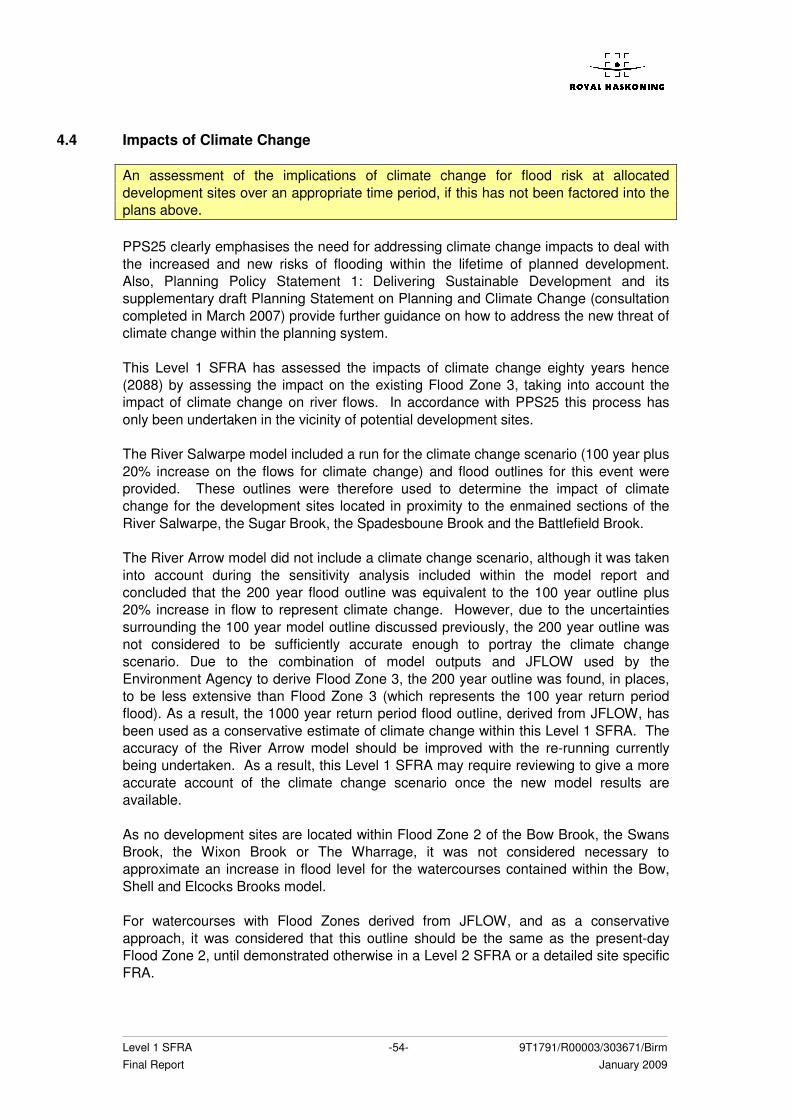
Level 1 SFRA -54- 9T1791/R00003/303671/Birm Final Report January 2009
4.4 Impacts of Climate Change
An assessment of the implications of climate change for flood risk at allocated development sites over an appropriate time period, if this has not been factored into the plans above. PPS25 clearly emphasises the need for addressing climate change impacts to deal with the increased and new risks of flooding within the lifetime of planned development. Also, Planning Policy Statement 1: Delivering Sustainable Development and its supplementary draft Planning Statement on Planning and Climate Change (consultation completed in March 2007) provide further guidance on how to address the new threat of climate change within the planning system. This Level 1 SFRA has assessed the impacts of climate change eighty years hence (2088) by assessing the impact on the existing Flood Zone 3, taking into account the impact of climate change on river flows. In accordance with PPS25 this process has only been undertaken in the vicinity of potential development sites. The River Salwarpe model included a run for the climate change scenario (100 year plus 20% increase on the flows for climate change) and flood outlines for this event were provided. These outlines were therefore used to determine the impact of climate change for the development sites located in proximity to the enmained sections of the River Salwarpe, the Sugar Brook, the Spadesboune Brook and the Battlefield Brook. The River Arrow model did not include a climate change scenario, although it was taken into account during the sensitivity analysis included within the model report and concluded that the 200 year flood outline was equivalent to the 100 year outline plus 20% increase in flow to represent climate change. However, due to the uncertainties surrounding the 100 year model outline discussed previously, the 200 year outline was not considered to be sufficiently accurate enough to portray the climate change scenario. Due to the combination of model outputs and JFLOW used by the Environment Agency to derive Flood Zone 3, the 200 year outline was found, in places, to be less extensive than Flood Zone 3 (which represents the 100 year return period flood). As a result, the 1000 year return period flood outline, derived from JFLOW, has been used as a conservative estimate of climate change within this Level 1 SFRA. The accuracy of the River Arrow model should be improved with the re-running currently being undertaken. As a result, this Level 1 SFRA may require reviewing to give a more accurate account of the climate change scenario once the new model results are available. As no development sites are located within Flood Zone 2 of the Bow Brook, the Swans Brook, the Wixon Brook or The Wharrage, it was not considered necessary to approximate an increase in flood level for the watercourses contained within the Bow, Shell and Elcocks Brooks model. For watercourses with Flood Zones derived from JFLOW, and as a conservative approach, it was considered that this outline should be the same as the present-day Flood Zone 2, until demonstrated otherwise in a Level 2 SFRA or a detailed site specific FRA.
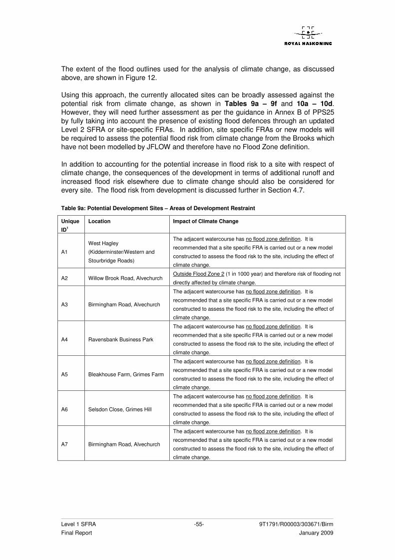
Level 1 SFRA -55- 9T1791/R00003/303671/Birm Final Report January 2009
The extent of the flood outlines used for the analysis of climate change, as discussed above, are shown in Figure 12. Using this approach, the currently allocated sites can be broadly assessed against the potential risk from climate change, as shown in Tables 9a – 9f and 10a – 10d. However, they will need further assessment as per the guidance in Annex B of PPS25 by fully taking into account the presence of existing flood defences through an updated Level 2 SFRA or site-specific FRAs. In addition, site specific FRAs or new models will be required to assess the potential flood risk from climate change from the Brooks which have not been modelled by JFLOW and therefore have no Flood Zone definition. In addition to accounting for the potential increase in flood risk to a site with respect of climate change, the consequences of the development in terms of additional runoff and increased flood risk elsewhere due to climate change should also be considered for every site. The flood risk from development is discussed further in Section 4.7. Table 9a: Potential Development Sites – Areas of Development Restraint
Unique
ID1
Location Impact of Climate Change
A1
West Hagley
(Kidderminster/Western and
Stourbridge Roads)
The adjacent watercourse has no flood zone definition. It is
recommended that a site specific FRA is carried out or a new model
constructed to assess the flood risk to the site, including the effect of
climate change.
A2 Willow Brook Road, Alvechurch Outside Flood Zone 2 (1 in 1000 year) and therefore risk of flooding not
directly affected by climate change.
A3 Birmingham Road, Alvechurch
The adjacent watercourse has no flood zone definition. It is
recommended that a site specific FRA is carried out or a new model
constructed to assess the flood risk to the site, including the effect of
climate change.
A4 Ravensbank Business Park
The adjacent watercourse has no flood zone definition. It is
recommended that a site specific FRA is carried out or a new model
constructed to assess the flood risk to the site, including the effect of
climate change.
A5 Bleakhouse Farm, Grimes Farm
The adjacent watercourse has no flood zone definition. It is
recommended that a site specific FRA is carried out or a new model
constructed to assess the flood risk to the site, including the effect of
climate change.
A6 Selsdon Close, Grimes Hill
The adjacent watercourse has no flood zone definition. It is
recommended that a site specific FRA is carried out or a new model
constructed to assess the flood risk to the site, including the effect of
climate change.
A7 Birmingham Road, Alvechurch
The adjacent watercourse has no flood zone definition. It is
recommended that a site specific FRA is carried out or a new model
constructed to assess the flood risk to the site, including the effect of
climate change.
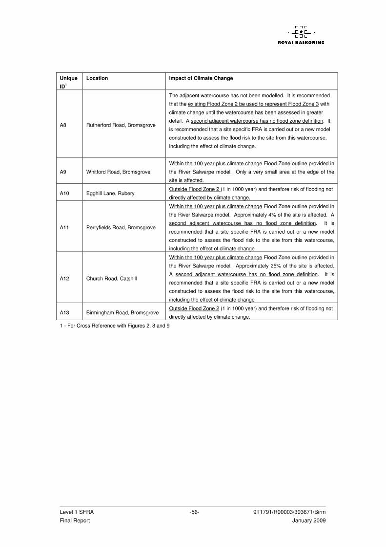
Level 1 SFRA -56- 9T1791/R00003/303671/Birm Final Report January 2009
Unique
ID1
Location Impact of Climate Change
A8 Rutherford Road, Bromsgrove
The adjacent watercourse has not been modelled. It is recommended
that the existing Flood Zone 2 be used to represent Flood Zone 3 with
climate change until the watercourse has been assessed in greater
detail. A second adjacent watercourse has no flood zone definition. It
is recommended that a site specific FRA is carried out or a new model
constructed to assess the flood risk to the site from this watercourse,
including the effect of climate change.
A9 Whitford Road, Bromsgrove
Within the 100 year plus climate change Flood Zone outline provided in
the River Salwarpe model. Only a very small area at the edge of the
site is affected.
A10 Egghill Lane, Rubery Outside Flood Zone 2 (1 in 1000 year) and therefore risk of flooding not
directly affected by climate change.
A11 Perryfields Road, Bromsgrove
Within the 100 year plus climate change Flood Zone outline provided in
the River Salwarpe model. Approximately 4% of the site is affected. A
second adjacent watercourse has no flood zone definition. It is
recommended that a site specific FRA is carried out or a new model
constructed to assess the flood risk to the site from this watercourse,
including the effect of climate change
A12 Church Road, Catshill
Within the 100 year plus climate change Flood Zone outline provided in
the River Salwarpe model. Approximately 25% of the site is affected.
A second adjacent watercourse has no flood zone definition. It is
recommended that a site specific FRA is carried out or a new model
constructed to assess the flood risk to the site from this watercourse,
including the effect of climate change
A13 Birmingham Road, Bromsgrove Outside Flood Zone 2 (1 in 1000 year) and therefore risk of flooding not
directly affected by climate change.
1 - For Cross Reference with Figures 2, 8 and 9
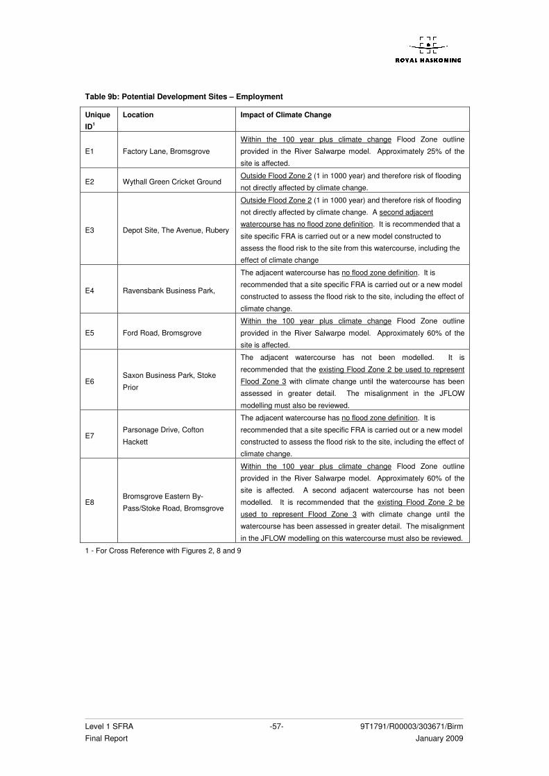
Level 1 SFRA -57- 9T1791/R00003/303671/Birm Final Report January 2009
Table 9b: Potential Development Sites – Employment
Unique
ID1
Location Impact of Climate Change
E1 Factory Lane, Bromsgrove
Within the 100 year plus climate change Flood Zone outline
provided in the River Salwarpe model. Approximately 25% of the
site is affected.
E2 Wythall Green Cricket Ground Outside Flood Zone 2 (1 in 1000 year) and therefore risk of flooding
not directly affected by climate change.
E3 Depot Site, The Avenue, Rubery
Outside Flood Zone 2 (1 in 1000 year) and therefore risk of flooding
not directly affected by climate change. A second adjacent
watercourse has no flood zone definition. It is recommended that a
site specific FRA is carried out or a new model constructed to
assess the flood risk to the site from this watercourse, including the
effect of climate change
E4 Ravensbank Business Park,
The adjacent watercourse has no flood zone definition. It is
recommended that a site specific FRA is carried out or a new model
constructed to assess the flood risk to the site, including the effect of
climate change.
E5 Ford Road, Bromsgrove
Within the 100 year plus climate change Flood Zone outline
provided in the River Salwarpe model. Approximately 60% of the
site is affected.
E6 Saxon Business Park, Stoke
Prior
The adjacent watercourse has not been modelled. It is
recommended that the existing Flood Zone 2 be used to represent
Flood Zone 3 with climate change until the watercourse has been
assessed in greater detail. The misalignment in the JFLOW
modelling must also be reviewed.
E7 Parsonage Drive, Cofton
Hackett
The adjacent watercourse has no flood zone definition. It is
recommended that a site specific FRA is carried out or a new model
constructed to assess the flood risk to the site, including the effect of
climate change.
E8 Bromsgrove Eastern By-
Pass/Stoke Road, Bromsgrove
Within the 100 year plus climate change Flood Zone outline
provided in the River Salwarpe model. Approximately 60% of the
site is affected. A second adjacent watercourse has not been
modelled. It is recommended that the existing Flood Zone 2 be
used to represent Flood Zone 3 with climate change until the
watercourse has been assessed in greater detail. The misalignment
in the JFLOW modelling on this watercourse must also be reviewed.
1 - For Cross Reference with Figures 2, 8 and 9
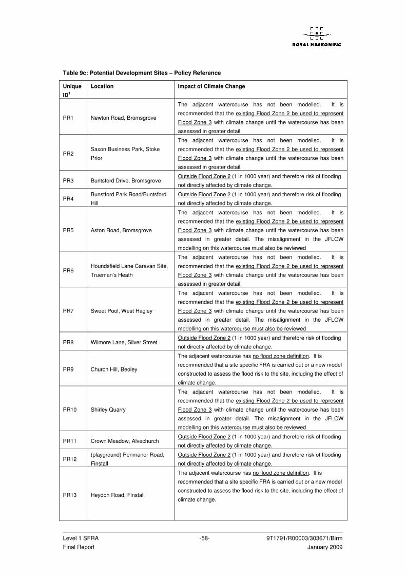
Level 1 SFRA -58- 9T1791/R00003/303671/Birm Final Report January 2009
Table 9c: Potential Development Sites – Policy Reference
Unique
ID1
Location Impact of Climate Change
PR1 Newton Road, Bromsgrove
The adjacent watercourse has not been modelled. It is
recommended that the existing Flood Zone 2 be used to represent
Flood Zone 3 with climate change until the watercourse has been
assessed in greater detail.
PR2 Saxon Business Park, Stoke
Prior
The adjacent watercourse has not been modelled. It is
recommended that the existing Flood Zone 2 be used to represent
Flood Zone 3 with climate change until the watercourse has been
assessed in greater detail.
PR3 Buntsford Drive, Bromsgrove Outside Flood Zone 2 (1 in 1000 year) and therefore risk of flooding
not directly affected by climate change.
PR4 Bunstford Park Road/Buntsford
Hill
Outside Flood Zone 2 (1 in 1000 year) and therefore risk of flooding
not directly affected by climate change.
PR5 Aston Road, Bromsgrove
The adjacent watercourse has not been modelled. It is
recommended that the existing Flood Zone 2 be used to represent
Flood Zone 3 with climate change until the watercourse has been
assessed in greater detail. The misalignment in the JFLOW
modelling on this watercourse must also be reviewed
PR6 Houndsfield Lane Caravan Site,
Trueman’s Heath
The adjacent watercourse has not been modelled. It is
recommended that the existing Flood Zone 2 be used to represent
Flood Zone 3 with climate change until the watercourse has been
assessed in greater detail.
PR7 Sweet Pool, West Hagley
The adjacent watercourse has not been modelled. It is
recommended that the existing Flood Zone 2 be used to represent
Flood Zone 3 with climate change until the watercourse has been
assessed in greater detail. The misalignment in the JFLOW
modelling on this watercourse must also be reviewed
PR8 Wilmore Lane, Silver Street Outside Flood Zone 2 (1 in 1000 year) and therefore risk of flooding
not directly affected by climate change.
PR9 Church Hill, Beoley
The adjacent watercourse has no flood zone definition. It is
recommended that a site specific FRA is carried out or a new model
constructed to assess the flood risk to the site, including the effect of
climate change.
PR10 Shirley Quarry
The adjacent watercourse has not been modelled. It is
recommended that the existing Flood Zone 2 be used to represent
Flood Zone 3 with climate change until the watercourse has been
assessed in greater detail. The misalignment in the JFLOW
modelling on this watercourse must also be reviewed
PR11 Crown Meadow, Alvechurch Outside Flood Zone 2 (1 in 1000 year) and therefore risk of flooding
not directly affected by climate change.
PR12 (playground) Penmanor Road,
Finstall
Outside Flood Zone 2 (1 in 1000 year) and therefore risk of flooding
not directly affected by climate change.
PR13 Heydon Road, Finstall
The adjacent watercourse has no flood zone definition. It is
recommended that a site specific FRA is carried out or a new model
constructed to assess the flood risk to the site, including the effect of
climate change.
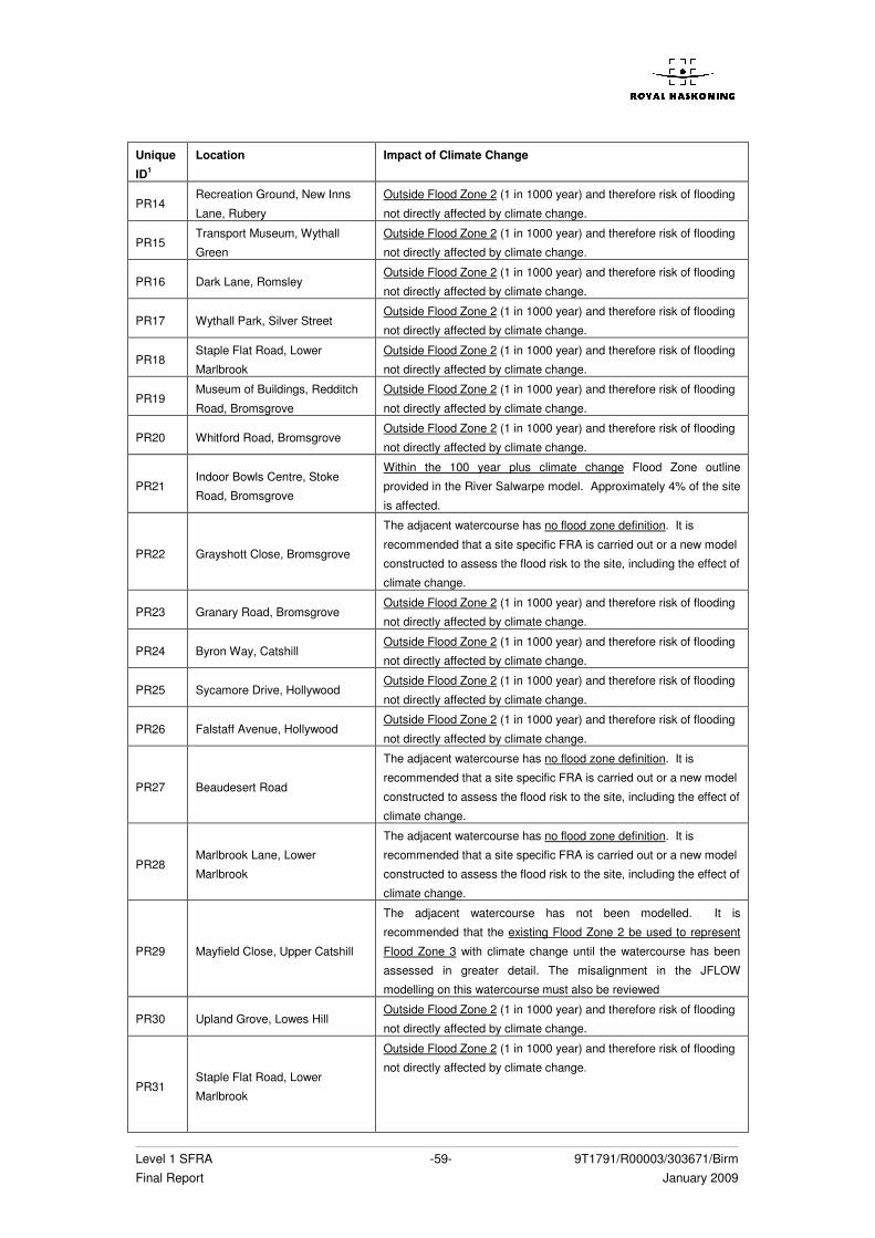
Level 1 SFRA -59- 9T1791/R00003/303671/Birm Final Report January 2009
Unique
ID1
Location Impact of Climate Change
PR14 Recreation Ground, New Inns
Lane, Rubery
Outside Flood Zone 2 (1 in 1000 year) and therefore risk of flooding
not directly affected by climate change.
PR15 Transport Museum, Wythall
Green
Outside Flood Zone 2 (1 in 1000 year) and therefore risk of flooding
not directly affected by climate change.
PR16 Dark Lane, Romsley Outside Flood Zone 2 (1 in 1000 year) and therefore risk of flooding
not directly affected by climate change.
PR17 Wythall Park, Silver Street Outside Flood Zone 2 (1 in 1000 year) and therefore risk of flooding
not directly affected by climate change.
PR18 Staple Flat Road, Lower
Marlbrook
Outside Flood Zone 2 (1 in 1000 year) and therefore risk of flooding
not directly affected by climate change.
PR19 Museum of Buildings, Redditch
Road, Bromsgrove
Outside Flood Zone 2 (1 in 1000 year) and therefore risk of flooding
not directly affected by climate change.
PR20 Whitford Road, Bromsgrove Outside Flood Zone 2 (1 in 1000 year) and therefore risk of flooding
not directly affected by climate change.
PR21 Indoor Bowls Centre, Stoke
Road, Bromsgrove
Within the 100 year plus climate change Flood Zone outline
provided in the River Salwarpe model. Approximately 4% of the site
is affected.
PR22 Grayshott Close, Bromsgrove
The adjacent watercourse has no flood zone definition. It is
recommended that a site specific FRA is carried out or a new model
constructed to assess the flood risk to the site, including the effect of
climate change.
PR23 Granary Road, Bromsgrove Outside Flood Zone 2 (1 in 1000 year) and therefore risk of flooding
not directly affected by climate change.
PR24 Byron Way, Catshill Outside Flood Zone 2 (1 in 1000 year) and therefore risk of flooding
not directly affected by climate change.
PR25 Sycamore Drive, Hollywood Outside Flood Zone 2 (1 in 1000 year) and therefore risk of flooding
not directly affected by climate change.
PR26 Falstaff Avenue, Hollywood Outside Flood Zone 2 (1 in 1000 year) and therefore risk of flooding
not directly affected by climate change.
PR27 Beaudesert Road
The adjacent watercourse has no flood zone definition. It is
recommended that a site specific FRA is carried out or a new model
constructed to assess the flood risk to the site, including the effect of
climate change.
PR28 Marlbrook Lane, Lower
Marlbrook
The adjacent watercourse has no flood zone definition. It is
recommended that a site specific FRA is carried out or a new model
constructed to assess the flood risk to the site, including the effect of
climate change.
PR29 Mayfield Close, Upper Catshill
The adjacent watercourse has not been modelled. It is
recommended that the existing Flood Zone 2 be used to represent
Flood Zone 3 with climate change until the watercourse has been
assessed in greater detail. The misalignment in the JFLOW
modelling on this watercourse must also be reviewed
PR30 Upland Grove, Lowes Hill Outside Flood Zone 2 (1 in 1000 year) and therefore risk of flooding
not directly affected by climate change.
PR31 Staple Flat Road, Lower
Marlbrook
Outside Flood Zone 2 (1 in 1000 year) and therefore risk of flooding
not directly affected by climate change.
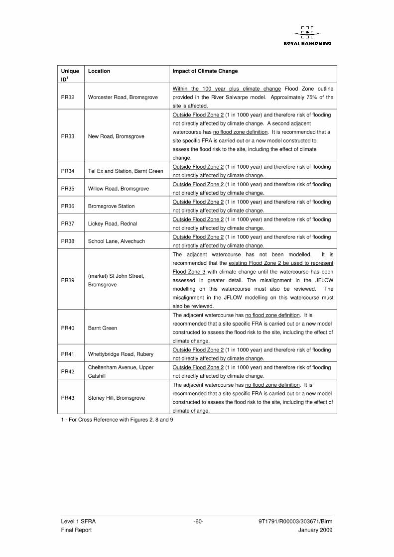
Level 1 SFRA -60- 9T1791/R00003/303671/Birm Final Report January 2009
Unique
ID1
Location Impact of Climate Change
PR32 Worcester Road, Bromsgrove
Within the 100 year plus climate change Flood Zone outline
provided in the River Salwarpe model. Approximately 75% of the
site is affected.
PR33 New Road, Bromsgrove
Outside Flood Zone 2 (1 in 1000 year) and therefore risk of flooding
not directly affected by climate change. A second adjacent
watercourse has no flood zone definition. It is recommended that a
site specific FRA is carried out or a new model constructed to
assess the flood risk to the site, including the effect of climate
change.
PR34 Tel Ex and Station, Barnt Green Outside Flood Zone 2 (1 in 1000 year) and therefore risk of flooding
not directly affected by climate change.
PR35 Willow Road, Bromsgrove Outside Flood Zone 2 (1 in 1000 year) and therefore risk of flooding
not directly affected by climate change.
PR36 Bromsgrove Station Outside Flood Zone 2 (1 in 1000 year) and therefore risk of flooding
not directly affected by climate change.
PR37 Lickey Road, Rednal Outside Flood Zone 2 (1 in 1000 year) and therefore risk of flooding
not directly affected by climate change.
PR38 School Lane, Alvechuch Outside Flood Zone 2 (1 in 1000 year) and therefore risk of flooding
not directly affected by climate change.
PR39 (market) St John Street,
Bromsgrove
The adjacent watercourse has not been modelled. It is
recommended that the existing Flood Zone 2 be used to represent
Flood Zone 3 with climate change until the watercourse has been
assessed in greater detail. The misalignment in the JFLOW
modelling on this watercourse must also be reviewed. The
misalignment in the JFLOW modelling on this watercourse must
also be reviewed.
PR40 Barnt Green
The adjacent watercourse has no flood zone definition. It is
recommended that a site specific FRA is carried out or a new model
constructed to assess the flood risk to the site, including the effect of
climate change.
PR41 Whettybridge Road, Rubery Outside Flood Zone 2 (1 in 1000 year) and therefore risk of flooding
not directly affected by climate change.
PR42 Cheltenham Avenue, Upper
Catshill
Outside Flood Zone 2 (1 in 1000 year) and therefore risk of flooding
not directly affected by climate change.
PR43 Stoney Hill, Bromsgrove
The adjacent watercourse has no flood zone definition. It is
recommended that a site specific FRA is carried out or a new model
constructed to assess the flood risk to the site, including the effect of
climate change.
1 - For Cross Reference with Figures 2, 8 and 9
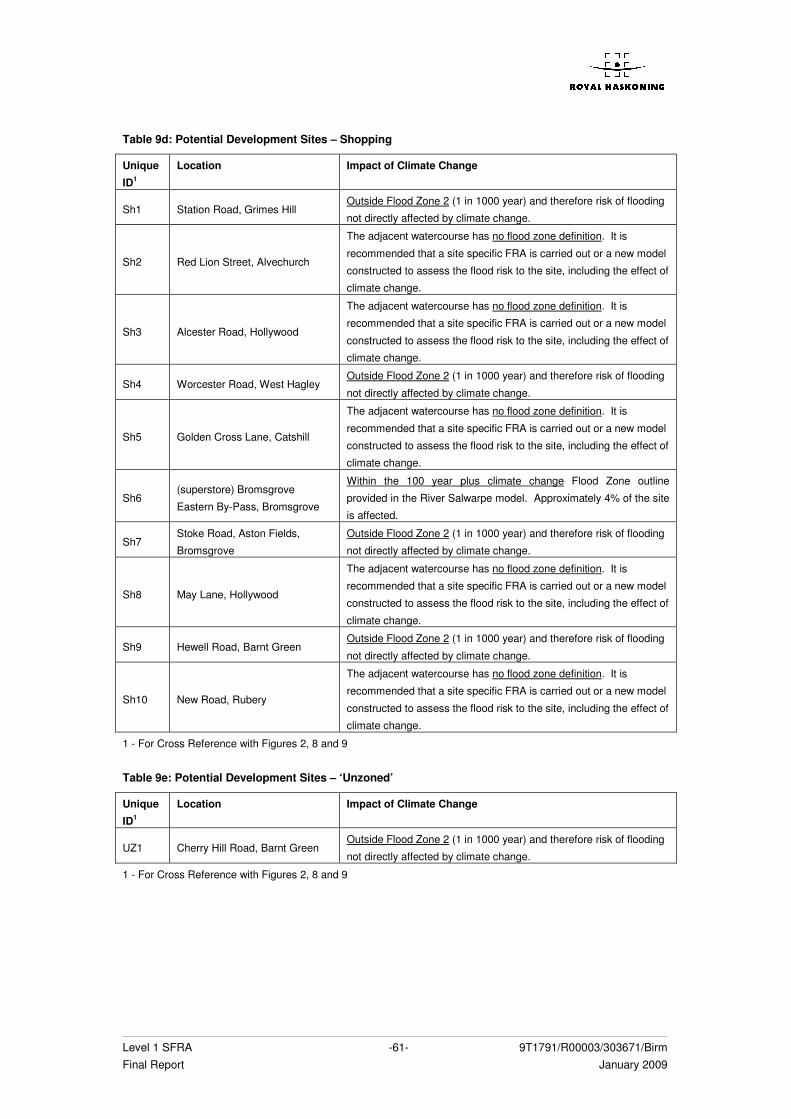
Level 1 SFRA -61- 9T1791/R00003/303671/Birm Final Report January 2009
Table 9d: Potential Development Sites – Shopping
Unique
ID1
Location Impact of Climate Change
Sh1 Station Road, Grimes Hill Outside Flood Zone 2 (1 in 1000 year) and therefore risk of flooding
not directly affected by climate change.
Sh2 Red Lion Street, Alvechurch
The adjacent watercourse has no flood zone definition. It is
recommended that a site specific FRA is carried out or a new model
constructed to assess the flood risk to the site, including the effect of
climate change.
Sh3 Alcester Road, Hollywood
The adjacent watercourse has no flood zone definition. It is
recommended that a site specific FRA is carried out or a new model
constructed to assess the flood risk to the site, including the effect of
climate change.
Sh4 Worcester Road, West Hagley Outside Flood Zone 2 (1 in 1000 year) and therefore risk of flooding
not directly affected by climate change.
Sh5 Golden Cross Lane, Catshill
The adjacent watercourse has no flood zone definition. It is
recommended that a site specific FRA is carried out or a new model
constructed to assess the flood risk to the site, including the effect of
climate change.
Sh6 (superstore) Bromsgrove
Eastern By-Pass, Bromsgrove
Within the 100 year plus climate change Flood Zone outline
provided in the River Salwarpe model. Approximately 4% of the site
is affected.
Sh7 Stoke Road, Aston Fields,
Bromsgrove
Outside Flood Zone 2 (1 in 1000 year) and therefore risk of flooding
not directly affected by climate change.
Sh8 May Lane, Hollywood
The adjacent watercourse has no flood zone definition. It is
recommended that a site specific FRA is carried out or a new model
constructed to assess the flood risk to the site, including the effect of
climate change.
Sh9 Hewell Road, Barnt Green Outside Flood Zone 2 (1 in 1000 year) and therefore risk of flooding
not directly affected by climate change.
Sh10 New Road, Rubery
The adjacent watercourse has no flood zone definition. It is
recommended that a site specific FRA is carried out or a new model
constructed to assess the flood risk to the site, including the effect of
climate change.
1 - For Cross Reference with Figures 2, 8 and 9 Table 9e: Potential Development Sites – ‘Unzoned’
Unique
ID1
Location Impact of Climate Change
UZ1 Cherry Hill Road, Barnt Green Outside Flood Zone 2 (1 in 1000 year) and therefore risk of flooding
not directly affected by climate change.
1 - For Cross Reference with Figures 2, 8 and 9
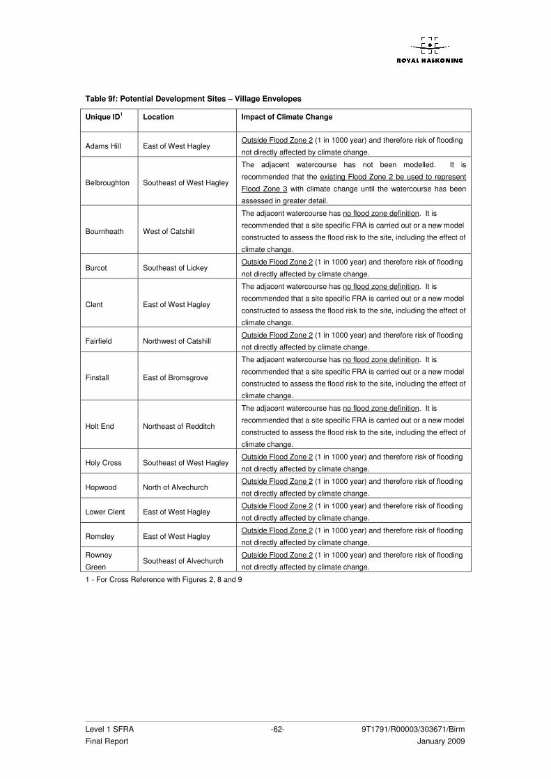
Level 1 SFRA -62- 9T1791/R00003/303671/Birm Final Report January 2009
Table 9f: Potential Development Sites – Village Envelopes
Unique ID1 Location Impact of Climate Change
Adams Hill East of West Hagley Outside Flood Zone 2 (1 in 1000 year) and therefore risk of flooding
not directly affected by climate change.
Belbroughton Southeast of West Hagley
The adjacent watercourse has not been modelled. It is
recommended that the existing Flood Zone 2 be used to represent
Flood Zone 3 with climate change until the watercourse has been
assessed in greater detail.
Bournheath West of Catshill
The adjacent watercourse has no flood zone definition. It is
recommended that a site specific FRA is carried out or a new model
constructed to assess the flood risk to the site, including the effect of
climate change.
Burcot Southeast of Lickey Outside Flood Zone 2 (1 in 1000 year) and therefore risk of flooding
not directly affected by climate change.
Clent East of West Hagley
The adjacent watercourse has no flood zone definition. It is
recommended that a site specific FRA is carried out or a new model
constructed to assess the flood risk to the site, including the effect of
climate change.
Fairfield Northwest of Catshill Outside Flood Zone 2 (1 in 1000 year) and therefore risk of flooding
not directly affected by climate change.
Finstall East of Bromsgrove
The adjacent watercourse has no flood zone definition. It is
recommended that a site specific FRA is carried out or a new model
constructed to assess the flood risk to the site, including the effect of
climate change.
Holt End Northeast of Redditch
The adjacent watercourse has no flood zone definition. It is
recommended that a site specific FRA is carried out or a new model
constructed to assess the flood risk to the site, including the effect of
climate change.
Holy Cross Southeast of West Hagley Outside Flood Zone 2 (1 in 1000 year) and therefore risk of flooding
not directly affected by climate change.
Hopwood North of Alvechurch Outside Flood Zone 2 (1 in 1000 year) and therefore risk of flooding
not directly affected by climate change.
Lower Clent East of West Hagley Outside Flood Zone 2 (1 in 1000 year) and therefore risk of flooding
not directly affected by climate change.
Romsley East of West Hagley Outside Flood Zone 2 (1 in 1000 year) and therefore risk of flooding
not directly affected by climate change.
Rowney
Green Southeast of Alvechurch
Outside Flood Zone 2 (1 in 1000 year) and therefore risk of flooding
not directly affected by climate change.
1 - For Cross Reference with Figures 2, 8 and 9
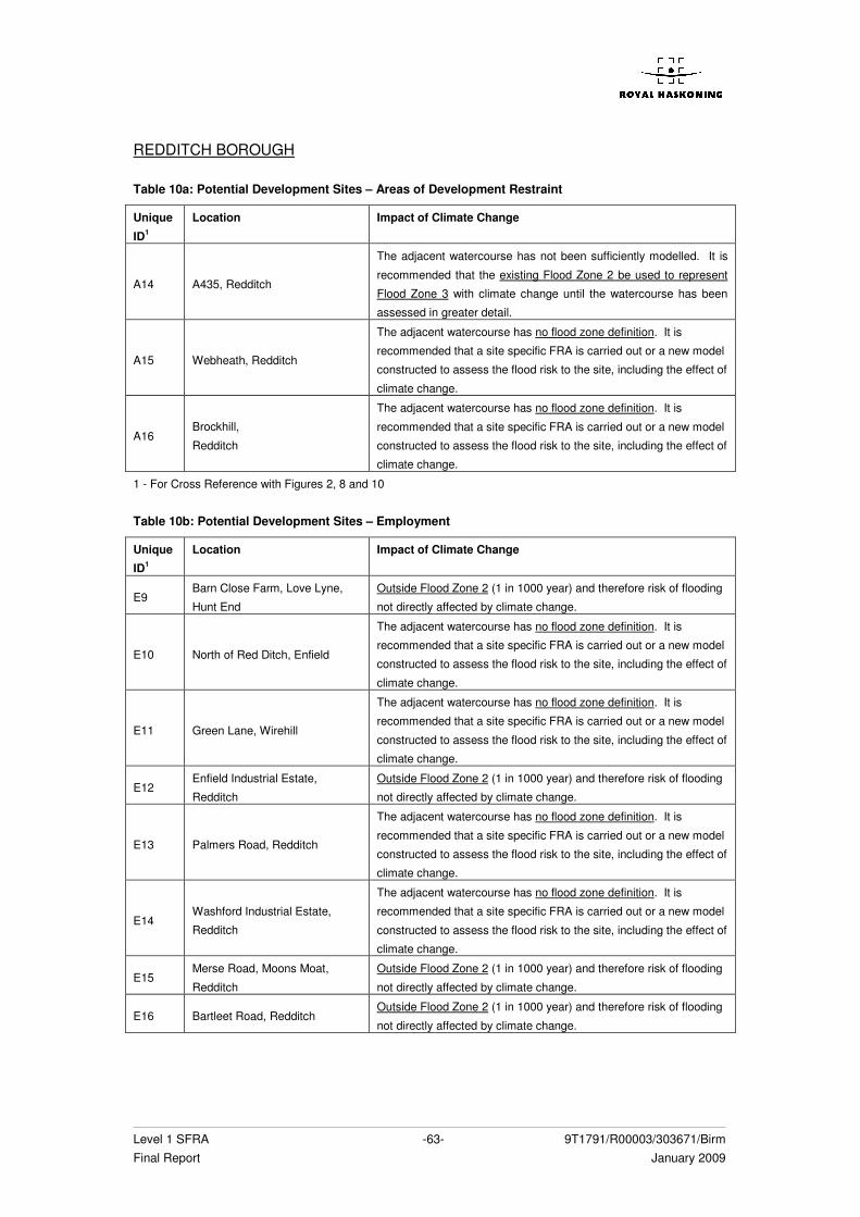
Level 1 SFRA -63- 9T1791/R00003/303671/Birm Final Report January 2009
REDDITCH BOROUGH Table 10a: Potential Development Sites – Areas of Development Restraint
Unique
ID1
Location Impact of Climate Change
A14 A435, Redditch
The adjacent watercourse has not been sufficiently modelled. It is
recommended that the existing Flood Zone 2 be used to represent
Flood Zone 3 with climate change until the watercourse has been
assessed in greater detail.
A15 Webheath, Redditch
The adjacent watercourse has no flood zone definition. It is
recommended that a site specific FRA is carried out or a new model
constructed to assess the flood risk to the site, including the effect of
climate change.
A16 Brockhill,
Redditch
The adjacent watercourse has no flood zone definition. It is
recommended that a site specific FRA is carried out or a new model
constructed to assess the flood risk to the site, including the effect of
climate change.
1 - For Cross Reference with Figures 2, 8 and 10 Table 10b: Potential Development Sites – Employment
Unique
ID1
Location Impact of Climate Change
E9 Barn Close Farm, Love Lyne,
Hunt End
Outside Flood Zone 2 (1 in 1000 year) and therefore risk of flooding
not directly affected by climate change.
E10 North of Red Ditch, Enfield
The adjacent watercourse has no flood zone definition. It is
recommended that a site specific FRA is carried out or a new model
constructed to assess the flood risk to the site, including the effect of
climate change.
E11 Green Lane, Wirehill
The adjacent watercourse has no flood zone definition. It is
recommended that a site specific FRA is carried out or a new model
constructed to assess the flood risk to the site, including the effect of
climate change.
E12 Enfield Industrial Estate,
Redditch
Outside Flood Zone 2 (1 in 1000 year) and therefore risk of flooding
not directly affected by climate change.
E13 Palmers Road, Redditch
The adjacent watercourse has no flood zone definition. It is
recommended that a site specific FRA is carried out or a new model
constructed to assess the flood risk to the site, including the effect of
climate change.
E14 Washford Industrial Estate,
Redditch
The adjacent watercourse has no flood zone definition. It is
recommended that a site specific FRA is carried out or a new model
constructed to assess the flood risk to the site, including the effect of
climate change.
E15 Merse Road, Moons Moat,
Redditch
Outside Flood Zone 2 (1 in 1000 year) and therefore risk of flooding
not directly affected by climate change.
E16 Bartleet Road, Redditch Outside Flood Zone 2 (1 in 1000 year) and therefore risk of flooding
not directly affected by climate change.
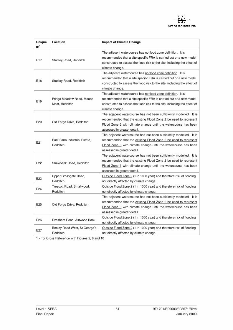
Level 1 SFRA -64- 9T1791/R00003/303671/Birm Final Report January 2009
Unique
ID1
Location Impact of Climate Change
E17 Studley Road, Redditch
The adjacent watercourse has no flood zone definition. It is
recommended that a site specific FRA is carried out or a new model
constructed to assess the flood risk to the site, including the effect of
climate change.
E18 Studley Road, Redditch
The adjacent watercourse has no flood zone definition. It is
recommended that a site specific FRA is carried out or a new model
constructed to assess the flood risk to the site, including the effect of
climate change.
E19 Fringe Meadow Road, Moons
Moat, Redditch
The adjacent watercourse has no flood zone definition. It is
recommended that a site specific FRA is carried out or a new model
constructed to assess the flood risk to the site, including the effect of
climate change.
E20 Old Forge Drive, Redditch
The adjacent watercourse has not been sufficiently modelled. It is
recommended that the existing Flood Zone 2 be used to represent
Flood Zone 3 with climate change until the watercourse has been
assessed in greater detail.
E21 Park Farm Industrial Estate,
Redditch
The adjacent watercourse has not been sufficiently modelled. It is
recommended that the existing Flood Zone 2 be used to represent
Flood Zone 3 with climate change until the watercourse has been
assessed in greater detail.
E22 Shawbank Road, Redditch
The adjacent watercourse has not been sufficiently modelled. It is
recommended that the existing Flood Zone 2 be used to represent
Flood Zone 3 with climate change until the watercourse has been
assessed in greater detail.
E23 Upper Crossgate Road,
Redditch
Outside Flood Zone 2 (1 in 1000 year) and therefore risk of flooding
not directly affected by climate change.
E24 Trescott Road, Smallwood,
Redditch
Outside Flood Zone 2 (1 in 1000 year) and therefore risk of flooding
not directly affected by climate change.
E25 Old Forge Drive, Redditch
The adjacent watercourse has not been sufficiently modelled. It is
recommended that the existing Flood Zone 2 be used to represent
Flood Zone 3 with climate change until the watercourse has been
assessed in greater detail.
E26 Evesham Road, Astwood Bank Outside Flood Zone 2 (1 in 1000 year) and therefore risk of flooding
not directly affected by climate change.
E27 Beoley Road West, St George’s,
Redditch
Outside Flood Zone 2 (1 in 1000 year) and therefore risk of flooding
not directly affected by climate change.
1 - For Cross Reference with Figures 2, 8 and 10
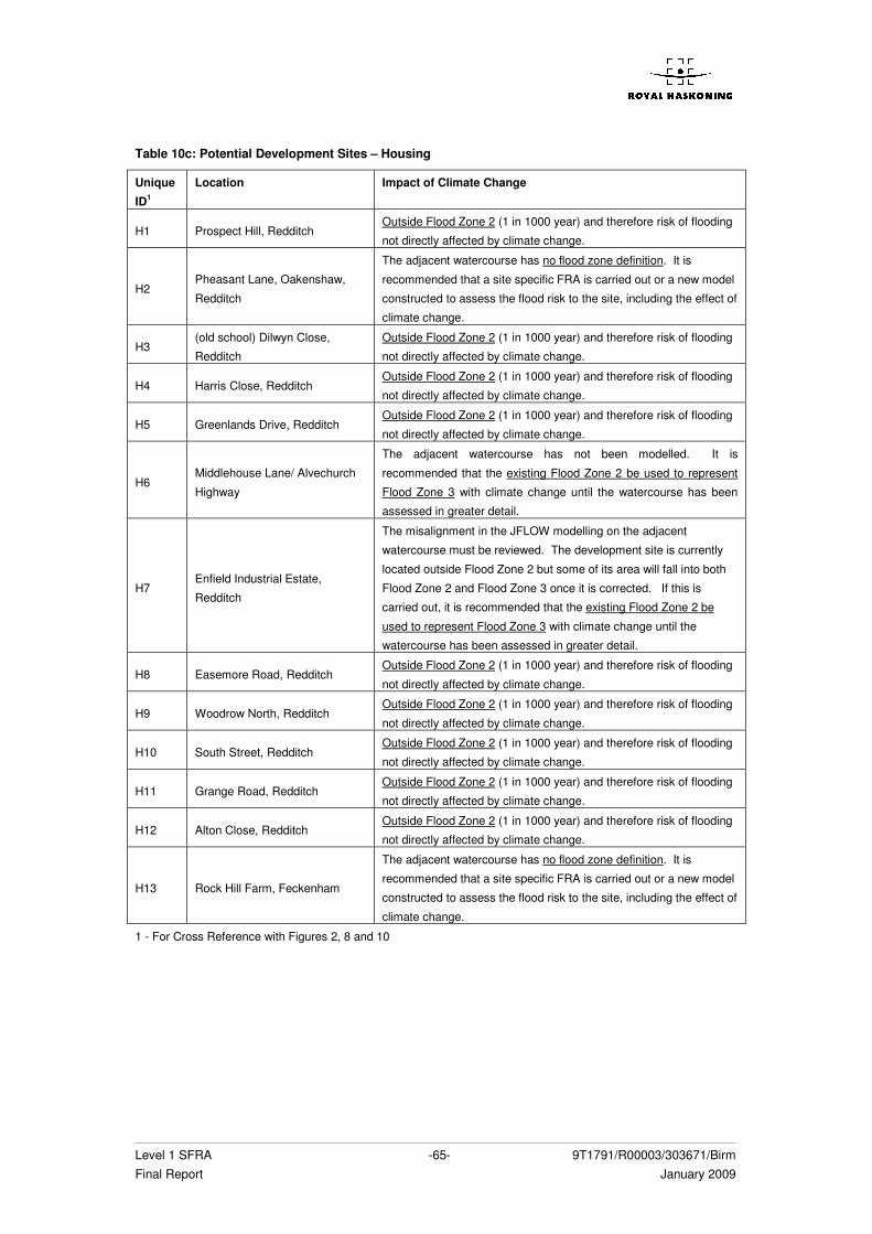
Level 1 SFRA -65- 9T1791/R00003/303671/Birm Final Report January 2009
Table 10c: Potential Development Sites – Housing
Unique
ID1
Location Impact of Climate Change
H1 Prospect Hill, Redditch Outside Flood Zone 2 (1 in 1000 year) and therefore risk of flooding
not directly affected by climate change.
H2 Pheasant Lane, Oakenshaw,
Redditch
The adjacent watercourse has no flood zone definition. It is
recommended that a site specific FRA is carried out or a new model
constructed to assess the flood risk to the site, including the effect of
climate change.
H3 (old school) Dilwyn Close,
Redditch
Outside Flood Zone 2 (1 in 1000 year) and therefore risk of flooding
not directly affected by climate change.
H4 Harris Close, Redditch Outside Flood Zone 2 (1 in 1000 year) and therefore risk of flooding
not directly affected by climate change.
H5 Greenlands Drive, Redditch Outside Flood Zone 2 (1 in 1000 year) and therefore risk of flooding
not directly affected by climate change.
H6 Middlehouse Lane/ Alvechurch
Highway
The adjacent watercourse has not been modelled. It is
recommended that the existing Flood Zone 2 be used to represent
Flood Zone 3 with climate change until the watercourse has been
assessed in greater detail.
H7 Enfield Industrial Estate,
Redditch
The misalignment in the JFLOW modelling on the adjacent
watercourse must be reviewed. The development site is currently
located outside Flood Zone 2 but some of its area will fall into both
Flood Zone 2 and Flood Zone 3 once it is corrected. If this is
carried out, it is recommended that the existing Flood Zone 2 be
used to represent Flood Zone 3 with climate change until the
watercourse has been assessed in greater detail.
H8 Easemore Road, Redditch Outside Flood Zone 2 (1 in 1000 year) and therefore risk of flooding
not directly affected by climate change.
H9 Woodrow North, Redditch Outside Flood Zone 2 (1 in 1000 year) and therefore risk of flooding
not directly affected by climate change.
H10 South Street, Redditch Outside Flood Zone 2 (1 in 1000 year) and therefore risk of flooding
not directly affected by climate change.
H11 Grange Road, Redditch Outside Flood Zone 2 (1 in 1000 year) and therefore risk of flooding
not directly affected by climate change.
H12 Alton Close, Redditch Outside Flood Zone 2 (1 in 1000 year) and therefore risk of flooding
not directly affected by climate change.
H13 Rock Hill Farm, Feckenham
The adjacent watercourse has no flood zone definition. It is
recommended that a site specific FRA is carried out or a new model
constructed to assess the flood risk to the site, including the effect of
climate change.
1 - For Cross Reference with Figures 2, 8 and 10
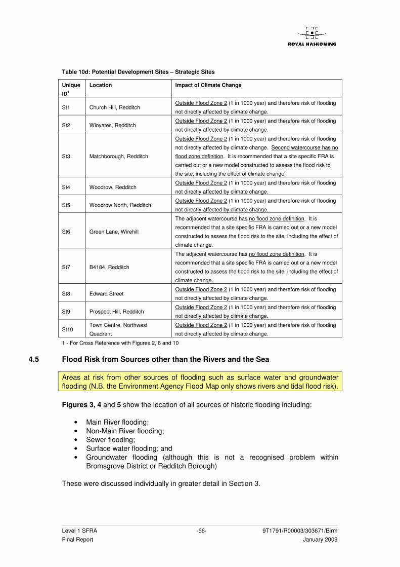
Level 1 SFRA -66- 9T1791/R00003/303671/Birm Final Report January 2009
Table 10d: Potential Development Sites – Strategic Sites
Unique
ID1
Location Impact of Climate Change
St1 Church Hill, Redditch Outside Flood Zone 2 (1 in 1000 year) and therefore risk of flooding
not directly affected by climate change.
St2 Winyates, Redditch Outside Flood Zone 2 (1 in 1000 year) and therefore risk of flooding
not directly affected by climate change.
St3 Matchborough, Redditch
Outside Flood Zone 2 (1 in 1000 year) and therefore risk of flooding
not directly affected by climate change. Second watercourse has no
flood zone definition. It is recommended that a site specific FRA is
carried out or a new model constructed to assess the flood risk to
the site, including the effect of climate change.
St4 Woodrow, Redditch Outside Flood Zone 2 (1 in 1000 year) and therefore risk of flooding
not directly affected by climate change.
St5 Woodrow North, Redditch Outside Flood Zone 2 (1 in 1000 year) and therefore risk of flooding
not directly affected by climate change.
St6 Green Lane, Wirehill
The adjacent watercourse has no flood zone definition. It is
recommended that a site specific FRA is carried out or a new model
constructed to assess the flood risk to the site, including the effect of
climate change.
St7 B4184, Redditch
The adjacent watercourse has no flood zone definition. It is
recommended that a site specific FRA is carried out or a new model
constructed to assess the flood risk to the site, including the effect of
climate change.
St8 Edward Street Outside Flood Zone 2 (1 in 1000 year) and therefore risk of flooding
not directly affected by climate change.
St9 Prospect Hill, Redditch Outside Flood Zone 2 (1 in 1000 year) and therefore risk of flooding
not directly affected by climate change.
St10 Town Centre, Northwest
Quadrant
Outside Flood Zone 2 (1 in 1000 year) and therefore risk of flooding
not directly affected by climate change.
1 - For Cross Reference with Figures 2, 8 and 10
4.5 Flood Risk from Sources other than the Rivers and the Sea
Areas at risk from other sources of flooding such as surface water and groundwater flooding (N.B. the Environment Agency Flood Map only shows rivers and tidal flood risk). Figures 3, 4 and 5 show the location of all sources of historic flooding including:
• Main River flooding; • Non-Main River flooding; • Sewer flooding; • Surface water flooding; and • Groundwater flooding (although this is not a recognised problem within
Bromsgrove District or Redditch Borough) These were discussed individually in greater detail in Section 3.
Level 1 SFRA -67- 9T1791/R00003/303671/Birm Final Report January 2009
4.5.1 Impact of Land Management Practices
As stated the MSfW report, ‘Identification of Catchments Sensitive to Land Use Change4, the generation of runoff from rural land is strongly influenced by a number of inherent physical characteristics, primarily the soils, topography and rainfall, together with the characteristics of the land cover on the surface. Therefore, the way in which the land has been managed, including cultivation techniques and livestock management systems have affected the pathways by which the incident rainfall moves over or through the soil and into the drainage network, including groundwater, streams and rivers. This Environment Agency report draws upon the conclusions of previous work undertaken by the National Soils Resources Institute as part of the Defra R&D Project, FD2114 which identified the following key land use/land management practices as most likely to give rise to the greatest hydrological impacts:
• Land drainage practices that alter the natural soil water regime; • Practices which keep the soil surface bare in inherently weakly structured sandy
and silty soils that are susceptible to crusting and compaction; and • Practices that require access to the land when the soil hydrological cycle is at or
approaching its wettest period thereby causing compaction (especially on soils with impeded drainage).
From this work the following agricultural systems have been defined within the Environment Agency report as vulnerable, in terms of making the soil susceptible to compaction and crusting problems:
• Late harvested arable crops (e.g. maize, sugarbeet, maincrop potatoes); • Autumn sown arable crops (winter cereals and winter OSR); • Managed grassland (especially sheep); • Orchards; • Winter harvested vegetables (e.g. winter cabbages, brussel sprouts, parsnips,
winter cauliflowers); and • Early potatoes and bulb flowers.
Once the soil has been compacted and crusted, the infiltration capacity is slowed and reduced. As a result, water from heavy rainstorms tends to pool on top of the soil and, where the topography is sloping, rapidly runs off the surface. This increases the speed at which rainwater falling on the catchments reaches the stream and river networks and the foul and surface water drainage systems. Due to the clayey and silty soils characterising much of the rural area of Bromsgrove District and Redditch Borough, reduced infiltration is already a widespread problem with regards to the creation of runoff, as discussed in Section 3.1.4. When the surface of the soil becomes compacted due to the farming practices mentioned above, the rapid runoff can cause local flooding problems. This was noted by the Bromsgrove Council Drainage Engineer as having occurred recently on Ashborough Hill, to the northeast of Bromsgrove Town, south of Lickey End, when sheep were left to graze on root crops. The topsoil became increasingly compacted and the resulting rapid runoff created from rain storms quickly flowed down the steep topography and caused local flooding in the housing estate located to the west of the A38. This has now been resolved through a change in landuse back to pasture land on the hillside. The effect of such events has been magnified due to a lack of capacity in the sewage networks (discussed in greater 4 ‘Delivery of Making Space for Water, HA6 Catchment Scale Land-Use Management, HA7 Land Management
Practices: Identification of Catchments Sensitive to Land Use Change’ EA, January 2008
Level 1 SFRA -68- 9T1791/R00003/303671/Birm Final Report January 2009
detail in the Water Cycle Strategy which accompanies this report) and a lack of consideration for surface water runoff in new developments. In addition a general lack of maintenance of agricultural land in general and, more specifically, field ditches, have also been blamed by the Council Drainage Engineers as increasing the effect of surface runoff. The lack of maintenance of the ditches has been associated with ownership problems between the Council, the Highways Agency and Private land owners. A paper regarding a new study into the impact of upland management on flooding has just been published by Jackson et al in the Journal of Flood Risk Management5. This study used a multidimensional physical based model to represent the Pontbren catchment in mid Wales which is noted for its clay soils, intensification of sheep farming and increasing flood runoff over the last decades. The model was used to examine the effects of planting a small strip of trees within a grassed clay hillslope and demonstrated that the careful placement of such interventions can reduce magnitudes of flood peaks by 40% at the field scale. The is due to the action of the trees on the soil tending to increase interception losses, available water storage within the soil and the rate at which water can move from the ground surface into the subsurface. The most beneficial location for the trees appears to be down-slope of areas where the water tends to collect on the surface. Due to the similarities in soil type and problems with surface water runoff, such mitigation techniques may also prove beneficial within the rural areas of Bromsgrove District and Redditch Borough.
4.5.2 Sustainability of Current Land Uses
Due to the characteristic soil type, topography and flooding problems associated with the rapid influx of runoff into the watercourses and sewer systems within Bromsgrove District and Redditch Borough, land use is an important consideration in terms of flood risk mitigation, both now and with regard to an increased risk of future flooding caused by climate change. With an increase in density and extent of development proposed within the study area, a reduction in runoff rate and volume may be a necessary precaution. The Environment Agency report, ‘Identification of Catchments Sensitive to Land Use Change’, available for download from the Defra website, identifies the potentially sensitive areas of England and Wales where changes in the current land use and associated land management practices may make the largest impact on flood risk management downstream in terms of land cover, soil, slope, rainfall and the combined effect of all these. The report displays the results on a broad scale, but indicates the following sensitivity of Bromsgrove District and Redditch Borough:
5 ‘The Impact of Upland Land Management on Flooding: insights from a multiscale experimental and modelling
programme’ Jackson et al, 2008, Journal of Flood Risk Management 1 pp71 - 80
Level 1 SFRA -69- 9T1791/R00003/303671/Birm Final Report January 2009
Table 11 – General Sensitivity of Bromsgrove District and Redditch Borough to Key Runoff Generation Parameters
Parameter Sensitivity
Land Cover Moderate to High
Soil Moderate to High
Slope Low to Moderate
Rainfall Low to Moderate
Combined Low to Moderate (High to the north of Bromsgrove District)
Table 11 indicates that the key parameters affecting runoff generation in the study area are land cover and soil type. This indicates a high proportion of sensitive land cover types within the Borough and District, such as cereals or horticulture. For these land uses to become sustainable and remain sustainable in the future, the adoption of farming practices which seek to reduce the rate and volume of runoff produced in the rural areas and an effort to increase the maintenance of land and ditches may be necessary in order to reduce some of the local surface water flooding problems identified within this report. The Environment Agency report, ‘The role of land use and land management in delivering flood risk management’6, identifies three delivery mechanisms to achieve changes in rural land use with potential benefits for flood risk:
• Regulation • Advice • Incentives
These are all explained in greater detail within the Environment Agency report, which is available to download from the Defra website. From the following link: www.defra.gov.uk/environ/fcd/adaptationandresilience/landmanagement.htm
4.6 Flood Risk Management Infrastructure and Flood Warning
The location of any flood risk management measures, including standard of infrastructure and the coverage of flood warning systems.
4.6.1 Defences
Section 3.4 of this report describes the existing flood risk management infrastructure within the District and Borough, including the standard of protection. This information is also presented graphically in Figure 11. The current Flood Warning and Flood Watch procedures are documented in Section 3.5. Tables 12a – 12f and 13a – 13d identify whether the potential development areas are protected by existing flood alleviation measures or flood warning systems. For such areas the future safety of the site from flooding will be dependent upon the future maintenance and operation of the flood defence.
6 ‘Delivery of Making Space for Water, HA6 Catchment Scale Land-Use Management, HA7 Land Management
Practices: The role of land use and land management in delivering flood risk management’ EA, January 2008
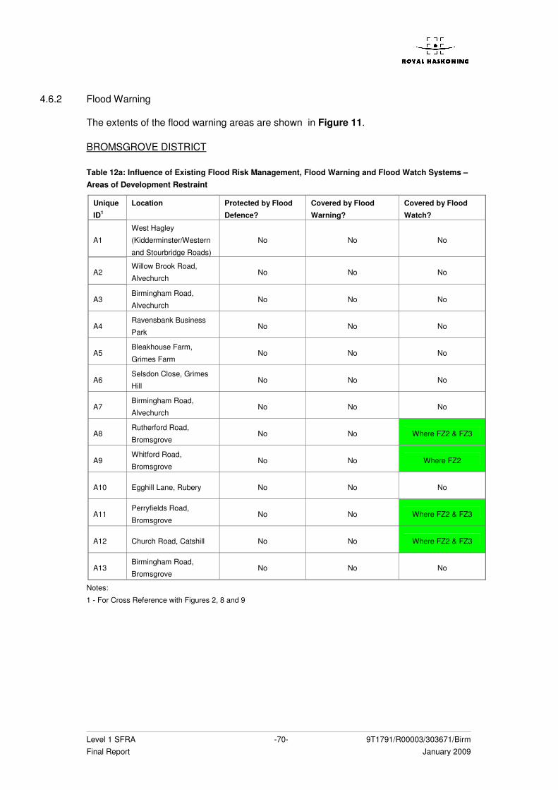
Level 1 SFRA -70- 9T1791/R00003/303671/Birm Final Report January 2009
4.6.2 Flood Warning
The extents of the flood warning areas are shown in Figure 11. BROMSGROVE DISTRICT Table 12a: Influence of Existing Flood Risk Management, Flood Warning and Flood Watch Systems – Areas of Development Restraint
Unique
ID1
Location Protected by Flood
Defence?
Covered by Flood
Warning?
Covered by Flood
Watch?
A1
West Hagley
(Kidderminster/Western
and Stourbridge Roads)
No No No
A2 Willow Brook Road,
Alvechurch No No No
A3 Birmingham Road,
Alvechurch No No No
A4 Ravensbank Business
Park No No No
A5 Bleakhouse Farm,
Grimes Farm No No No
A6 Selsdon Close, Grimes
Hill No No No
A7 Birmingham Road,
Alvechurch No No No
A8 Rutherford Road,
Bromsgrove No No Where FZ2 & FZ3
A9 Whitford Road,
Bromsgrove No No Where FZ2
A10 Egghill Lane, Rubery No No No
A11 Perryfields Road,
Bromsgrove No No Where FZ2 & FZ3
A12 Church Road, Catshill No No Where FZ2 & FZ3
A13 Birmingham Road,
Bromsgrove No No No
Notes:
1 - For Cross Reference with Figures 2, 8 and 9
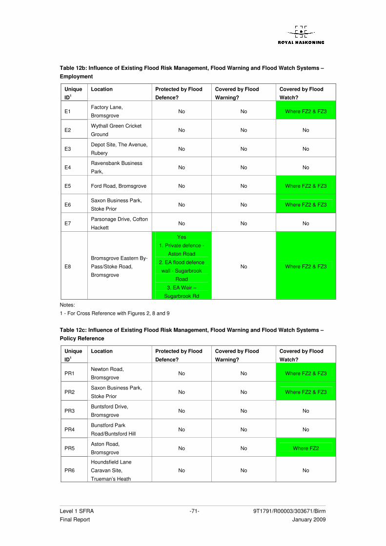
Level 1 SFRA -71- 9T1791/R00003/303671/Birm Final Report January 2009
Table 12b: Influence of Existing Flood Risk Management, Flood Warning and Flood Watch Systems – Employment
Unique
ID1
Location Protected by Flood
Defence?
Covered by Flood
Warning?
Covered by Flood
Watch?
E1 Factory Lane,
Bromsgrove No No Where FZ2 & FZ3
E2 Wythall Green Cricket
Ground No No No
E3 Depot Site, The Avenue,
Rubery No No No
E4 Ravensbank Business
Park, No No No
E5 Ford Road, Bromsgrove No No Where FZ2 & FZ3
E6 Saxon Business Park,
Stoke Prior No No Where FZ2 & FZ3
E7 Parsonage Drive, Cofton
Hackett No No No
E8
Bromsgrove Eastern By-
Pass/Stoke Road,
Bromsgrove
Yes
1. Private defence -
Aston Road
2. EA flood defence
wall - Sugarbrook
Road
3. EA Weir –
Sugarbrook Rd
No Where FZ2 & FZ3
Notes:
1 - For Cross Reference with Figures 2, 8 and 9 Table 12c: Influence of Existing Flood Risk Management, Flood Warning and Flood Watch Systems – Policy Reference
Unique
ID1
Location Protected by Flood
Defence?
Covered by Flood
Warning?
Covered by Flood
Watch?
PR1 Newton Road,
Bromsgrove No No Where FZ2 & FZ3
PR2 Saxon Business Park,
Stoke Prior No No Where FZ2 & FZ3
PR3 Buntsford Drive,
Bromsgrove No No No
PR4 Bunstford Park
Road/Buntsford Hill No No No
PR5 Aston Road,
Bromsgrove No No Where FZ2
PR6
Houndsfield Lane
Caravan Site,
Trueman’s Heath
No No No

Level 1 SFRA -72- 9T1791/R00003/303671/Birm Final Report January 2009
Unique
ID1
Location Protected by Flood
Defence?
Covered by Flood
Warning?
Covered by Flood
Watch?
PR7 Sweet Pool, West
Hagley No No No
PR8 Wilmore Lane, Silver
Street No No No
PR9 Church Hill, Beoley No No No
PR10 Shirley Quarry No No No
PR11 Crown Meadow,
Alvechurch No No No
PR12 (playground) Penmanor
Road, Finstall No No No
PR13 Heydon Road, Finstall No No No
PR14 Recreation Ground, New
Inns Lane, Rubery No No No
PR15 Transport Museum,
Wythall Green No No No
PR16 Dark Lane, Romsley No No No
PR17 Wythall Park, Silver
Street No No No
PR18 Staple Flat Road, Lower
Marlbrook No No No
PR19
Museum of Buildings,
Redditch Road,
Bromsgrove
No No No
PR20 Whitford Road,
Bromsgrove No No No
PR21
Indoor Bowls Centre,
Stoke Road,
Bromsgrove
No No Where FZ2 & FZ3
PR22 Grayshott Close,
Bromsgrove No No No
PR23 Granary Road,
Bromsgrove No No No
PR24 Byron Way, Catshill No No No
PR25 Sycamore Drive,
Hollywood No No No
PR26 Falstaff Avenue,
Hollywood No No No
PR27 Beaudesert Road No No No
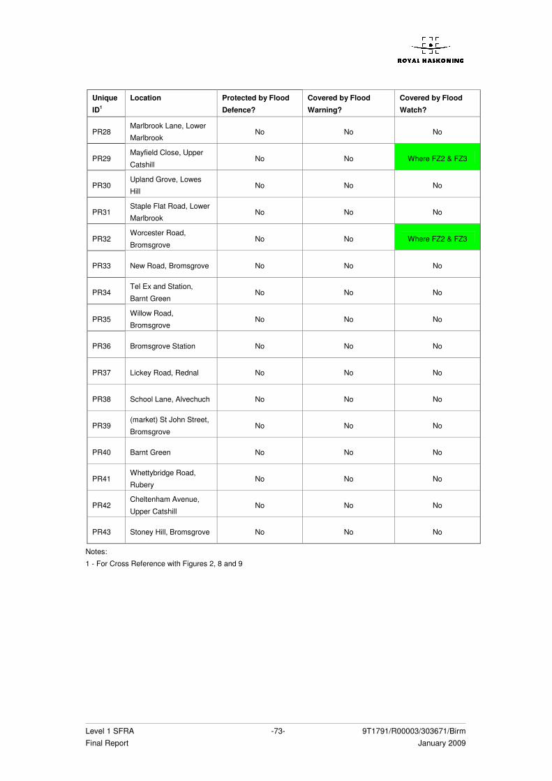
Level 1 SFRA -73- 9T1791/R00003/303671/Birm Final Report January 2009
Unique
ID1
Location Protected by Flood
Defence?
Covered by Flood
Warning?
Covered by Flood
Watch?
PR28 Marlbrook Lane, Lower
Marlbrook No No No
PR29 Mayfield Close, Upper
Catshill No No Where FZ2 & FZ3
PR30 Upland Grove, Lowes
Hill No No No
PR31 Staple Flat Road, Lower
Marlbrook No No No
PR32 Worcester Road,
Bromsgrove No No Where FZ2 & FZ3
PR33 New Road, Bromsgrove No No No
PR34 Tel Ex and Station,
Barnt Green No No No
PR35 Willow Road,
Bromsgrove No No No
PR36 Bromsgrove Station No No No
PR37 Lickey Road, Rednal No No No
PR38 School Lane, Alvechuch No No No
PR39 (market) St John Street,
Bromsgrove No No No
PR40 Barnt Green No No No
PR41 Whettybridge Road,
Rubery No No No
PR42 Cheltenham Avenue,
Upper Catshill No No No
PR43 Stoney Hill, Bromsgrove No No No
Notes:
1 - For Cross Reference with Figures 2, 8 and 9
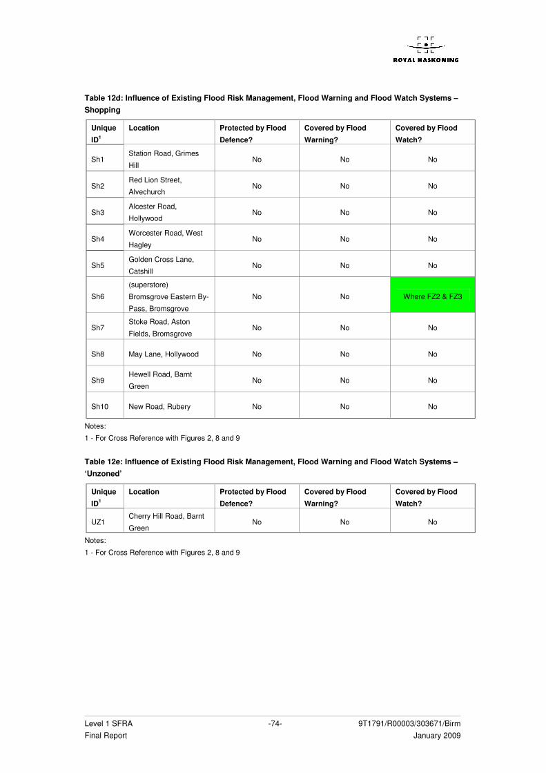
Level 1 SFRA -74- 9T1791/R00003/303671/Birm Final Report January 2009
Table 12d: Influence of Existing Flood Risk Management, Flood Warning and Flood Watch Systems – Shopping
Unique
ID1
Location Protected by Flood
Defence?
Covered by Flood
Warning?
Covered by Flood
Watch?
Sh1 Station Road, Grimes
Hill No No No
Sh2 Red Lion Street,
Alvechurch No No No
Sh3 Alcester Road,
Hollywood No No No
Sh4 Worcester Road, West
Hagley No No No
Sh5 Golden Cross Lane,
Catshill No No No
Sh6
(superstore)
Bromsgrove Eastern By-
Pass, Bromsgrove
No No Where FZ2 & FZ3
Sh7 Stoke Road, Aston
Fields, Bromsgrove No No No
Sh8 May Lane, Hollywood No No No
Sh9 Hewell Road, Barnt
Green No No No
Sh10 New Road, Rubery No No No
Notes:
1 - For Cross Reference with Figures 2, 8 and 9
Table 12e: Influence of Existing Flood Risk Management, Flood Warning and Flood Watch Systems – ‘Unzoned’
Unique
ID1
Location Protected by Flood
Defence?
Covered by Flood
Warning?
Covered by Flood
Watch?
UZ1 Cherry Hill Road, Barnt
Green No No No
Notes:
1 - For Cross Reference with Figures 2, 8 and 9
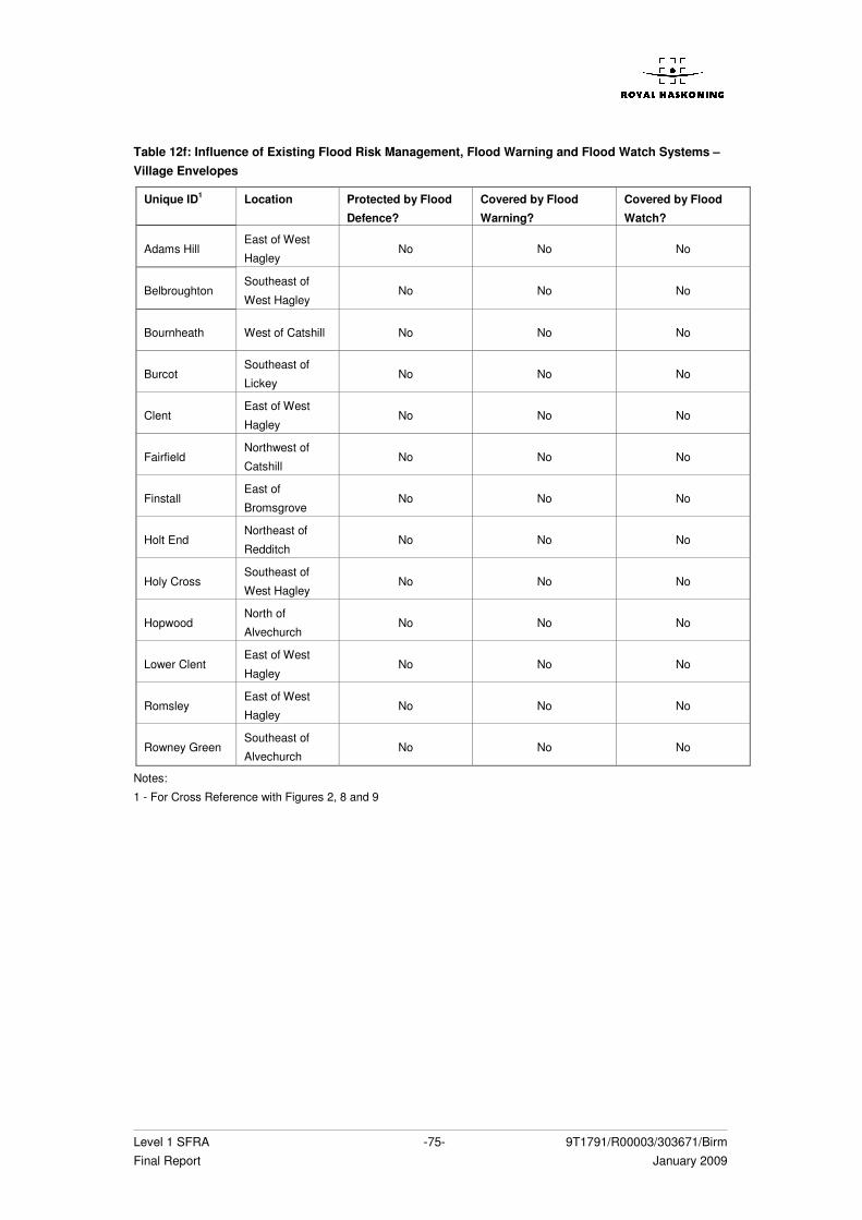
Level 1 SFRA -75- 9T1791/R00003/303671/Birm Final Report January 2009
Table 12f: Influence of Existing Flood Risk Management, Flood Warning and Flood Watch Systems – Village Envelopes
Unique ID1 Location Protected by Flood
Defence?
Covered by Flood
Warning?
Covered by Flood
Watch?
Adams Hill East of West
Hagley No No No
Belbroughton Southeast of
West Hagley No No No
Bournheath West of Catshill No No No
Burcot Southeast of
Lickey No No No
Clent East of West
Hagley No No No
Fairfield Northwest of
Catshill No No No
Finstall East of
Bromsgrove No No No
Holt End Northeast of
Redditch No No No
Holy Cross Southeast of
West Hagley No No No
Hopwood North of
Alvechurch No No No
Lower Clent East of West
Hagley No No No
Romsley East of West
Hagley No No No
Rowney Green Southeast of
Alvechurch No No No
Notes:
1 - For Cross Reference with Figures 2, 8 and 9
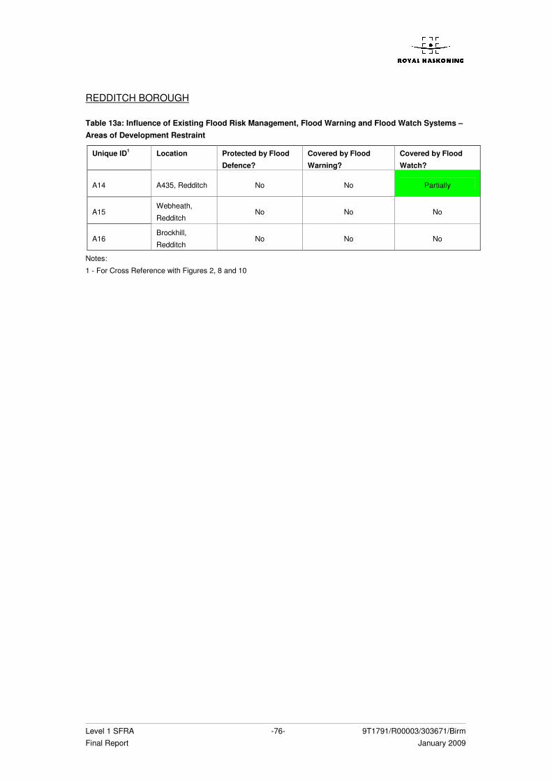
Level 1 SFRA -76- 9T1791/R00003/303671/Birm Final Report January 2009
REDDITCH BOROUGH Table 13a: Influence of Existing Flood Risk Management, Flood Warning and Flood Watch Systems – Areas of Development Restraint
Unique ID1 Location Protected by Flood
Defence?
Covered by Flood
Warning?
Covered by Flood
Watch?
A14 A435, Redditch No No Partially
A15 Webheath,
Redditch No No No
A16 Brockhill,
Redditch No No No
Notes:
1 - For Cross Reference with Figures 2, 8 and 10
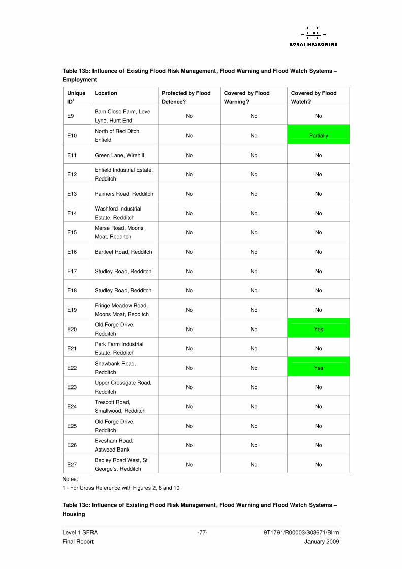
Level 1 SFRA -77- 9T1791/R00003/303671/Birm Final Report January 2009
Table 13b: Influence of Existing Flood Risk Management, Flood Warning and Flood Watch Systems – Employment
Unique
ID1
Location Protected by Flood
Defence?
Covered by Flood
Warning?
Covered by Flood
Watch?
E9 Barn Close Farm, Love
Lyne, Hunt End No No No
E10 North of Red Ditch,
Enfield No No Partially
E11 Green Lane, Wirehill No No No
E12 Enfield Industrial Estate,
Redditch No No No
E13 Palmers Road, Redditch No No No
E14 Washford Industrial
Estate, Redditch No No No
E15 Merse Road, Moons
Moat, Redditch No No No
E16 Bartleet Road, Redditch No No No
E17 Studley Road, Redditch No No No
E18 Studley Road, Redditch No No No
E19 Fringe Meadow Road,
Moons Moat, Redditch No No No
E20 Old Forge Drive,
Redditch No No Yes
E21 Park Farm Industrial
Estate, Redditch No No No
E22 Shawbank Road,
Redditch No No Yes
E23 Upper Crossgate Road,
Redditch No No No
E24 Trescott Road,
Smallwood, Redditch No No No
E25 Old Forge Drive,
Redditch No No No
E26 Evesham Road,
Astwood Bank No No No
E27 Beoley Road West, St
George’s, Redditch No No No
Notes:
1 - For Cross Reference with Figures 2, 8 and 10 Table 13c: Influence of Existing Flood Risk Management, Flood Warning and Flood Watch Systems – Housing
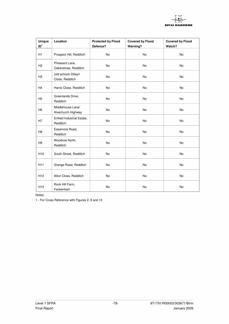
Level 1 SFRA -78- 9T1791/R00003/303671/Birm Final Report January 2009
Unique
ID1
Location Protected by Flood
Defence?
Covered by Flood
Warning?
Covered by Flood
Watch?
H1 Prospect Hill, Redditch No No No
H2 Pheasant Lane,
Oakenshaw, Redditch No No No
H3 (old school) Dilwyn
Close, Redditch No No No
H4 Harris Close, Redditch No No No
H5 Greenlands Drive,
Redditch No No No
H6 Middlehouse Lane/
Alvechurch Highway No No No
H7 Enfield Industrial Estate,
Redditch No No No
H8 Easemore Road,
Redditch No No No
H9 Woodrow North,
Redditch No No No
H10 South Street, Redditch No No No
H11 Grange Road, Redditch No No No
H12 Alton Close, Redditch No No No
H13 Rock Hill Farm,
Feckenham No No No
Notes:
1 - For Cross Reference with Figures 2, 8 and 10
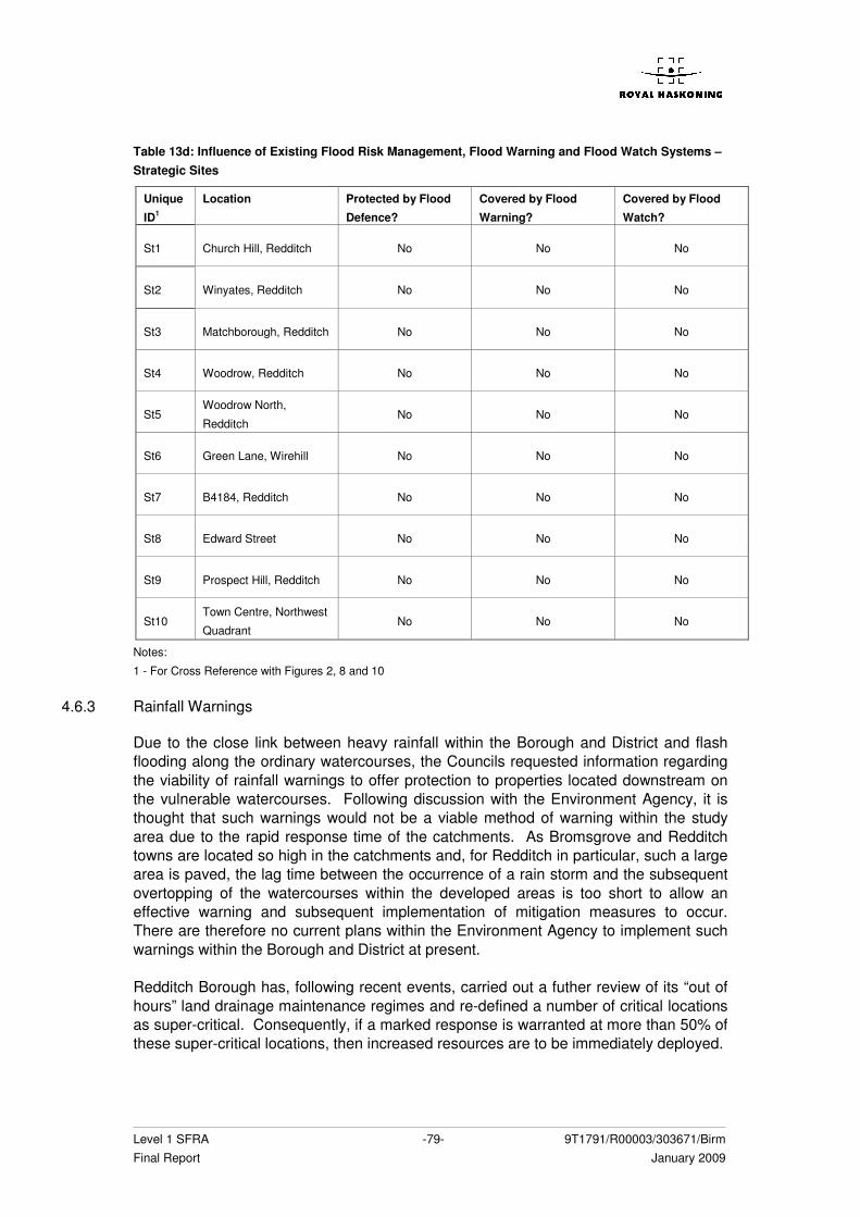
Level 1 SFRA -79- 9T1791/R00003/303671/Birm Final Report January 2009
Table 13d: Influence of Existing Flood Risk Management, Flood Warning and Flood Watch Systems – Strategic Sites
Unique
ID1
Location Protected by Flood
Defence?
Covered by Flood
Warning?
Covered by Flood
Watch?
St1 Church Hill, Redditch No No No
St2 Winyates, Redditch No No No
St3 Matchborough, Redditch No No No
St4 Woodrow, Redditch No No No
St5 Woodrow North,
Redditch No No No
St6 Green Lane, Wirehill No No No
St7 B4184, Redditch No No No
St8 Edward Street No No No
St9 Prospect Hill, Redditch No No No
St10 Town Centre, Northwest
Quadrant No No No
Notes:
1 - For Cross Reference with Figures 2, 8 and 10
4.6.3 Rainfall Warnings
Due to the close link between heavy rainfall within the Borough and District and flash flooding along the ordinary watercourses, the Councils requested information regarding the viability of rainfall warnings to offer protection to properties located downstream on the vulnerable watercourses. Following discussion with the Environment Agency, it is thought that such warnings would not be a viable method of warning within the study area due to the rapid response time of the catchments. As Bromsgrove and Redditch towns are located so high in the catchments and, for Redditch in particular, such a large area is paved, the lag time between the occurrence of a rain storm and the subsequent overtopping of the watercourses within the developed areas is too short to allow an effective warning and subsequent implementation of mitigation measures to occur. There are therefore no current plans within the Environment Agency to implement such warnings within the Borough and District at present. Redditch Borough has, following recent events, carried out a futher review of its “out of hours” land drainage maintenance regimes and re-defined a number of critical locations as super-critical. Consequently, if a marked response is warranted at more than 50% of these super-critical locations, then increased resources are to be immediately deployed.
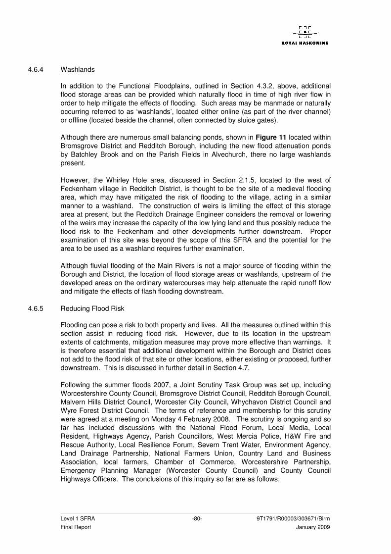
Level 1 SFRA -80- 9T1791/R00003/303671/Birm Final Report January 2009
4.6.4 Washlands
In addition to the Functional Floodplains, outlined in Section 4.3.2, above, additional flood storage areas can be provided which naturally flood in time of high river flow in order to help mitigate the effects of flooding. Such areas may be manmade or naturally occurring referred to as ‘washlands’, located either online (as part of the river channel) or offline (located beside the channel, often connected by sluice gates). Although there are numerous small balancing ponds, shown in Figure 11 located within Bromsgrove District and Redditch Borough, including the new flood attenuation ponds by Batchley Brook and on the Parish Fields in Alvechurch, there no large washlands present. However, the Whirley Hole area, discussed in Section 2.1.5, located to the west of Feckenham village in Redditch District, is thought to be the site of a medieval flooding area, which may have mitigated the risk of flooding to the village, acting in a similar manner to a washland. The construction of weirs is limiting the effect of this storage area at present, but the Redditch Drainage Engineer considers the removal or lowering of the weirs may increase the capacity of the low lying land and thus possibly reduce the flood risk to the Feckenham and other developments further downstream. Proper examination of this site was beyond the scope of this SFRA and the potential for the area to be used as a washland requires further examination. Although fluvial flooding of the Main Rivers is not a major source of flooding within the Borough and District, the location of flood storage areas or washlands, upstream of the developed areas on the ordinary watercourses may help attenuate the rapid runoff flow and mitigate the effects of flash flooding downstream.
4.6.5 Reducing Flood Risk
Flooding can pose a risk to both property and lives. All the measures outlined within this section assist in reducing flood risk. However, due to its location in the upstream extents of catchments, mitigation measures may prove more effective than warnings. It is therefore essential that additional development within the Borough and District does not add to the flood risk of that site or other locations, either existing or proposed, further downstream. This is discussed in further detail in Section 4.7. Following the summer floods 2007, a Joint Scrutiny Task Group was set up, including Worcestershire County Council, Bromsgrove District Council, Redditch Borough Council, Malvern Hills District Council, Worcester City Council, Whychavon District Council and Wyre Forest District Council. The terms of reference and membership for this scrutiny were agreed at a meeting on Monday 4 February 2008. The scrutiny is ongoing and so far has included discussions with the National Flood Forum, Local Media, Local Resident, Highways Agency, Parish Councillors, West Mercia Police, H&W Fire and Rescue Authority, Local Resilience Forum, Severn Trent Water, Environment Agency, Land Drainage Partnership, National Farmers Union, Country Land and Business Association, local farmers, Chamber of Commerce, Worcestershire Partnership, Emergency Planning Manager (Worcester County Council) and County Council Highways Officers. The conclusions of this inquiry so far are as follows:
Level 1 SFRA -81- 9T1791/R00003/303671/Birm Final Report January 2009
• A single point of contact should be made available for road closures and/or road closed signs should be stored in the local area;
• Sandbags should be stored locally; • Maintenance of drains and ditches, possibly with a ditch and watercourse
register to show who or which organisation was responsible; • However, the wider catchment area needs consideration as water channel
clearance may make flooding worse for a community downstream; • District Councils should make use of their powers to serve enforcement orders
on landowners who did not comply with requests to maintain their ditches and/or watercourses and, under the community Act 2000, should carry out necessary work to repair watercourses if the land owner could not afford to do so;
• Parish Lengthsman should be used to advise the County Council drain clearance team of main flooding areas;
• Increased flexibility between partner organisations – the Civil Contingencies Act 2004 came into force in November 2005 and requires organisations to work together in a more formalised framework – including out of hours emergency phonelines;
• Giving parishes the necessary tools and support to help in an emergency; • The production of a green map for every parish to show which houses had
flooded and the extent and direction of the flow of flood waters, with an initial focus on critical areas;
• A draft multi-agency communications plan has been agreed after consultation on 18 March 2008 and would be tested to resolve the communications problems experience between Silver control members during the June 2007 flood event;
• Weaknesses have been identified within the emergency rescue service, resulting from lack of funding, lack of coordination in a national system and some communications difficulties;
• A need to review of the process of providing alternative water supplies in the event of water treatment work failure, as occurred at Mythe;
• A need to review of when to form the crisis management team; • A need to review the adequacy of flood defences; • The need to review and mitigate the effect of flooding on sewage treatment
works; • Dredging is not a cost effective way of reducing flood risk; • Better maintenance of highway drainage; • Enlargement of some culverts; • More use should be made of local farmers, with maintenance of an inventory of
equipment help by local farmers which could be useful in alleviating flooding and drainage;
• Maintenance of a list of approved contractors with a variety of different skills to be called upon as required during and after an emergency;
• Increased staff capacity during the recovery period; • Sharing of local authority resources during an emergency; • A dedicated local authority floodline; • Supporting of Emergency Planning at a much more local level; • Increased use of local knowledge and skilled armed forces; • The provision of a county and district emergency plan template or ‘blueprint’ to
allow parishes which may be affected by flooding to aid with its completion. The completion of this Scrutiny report will aid the Councils with the development of Emergency Flood Plans and Warnings.
Level 1 SFRA -82- 9T1791/R00003/303671/Birm Final Report January 2009
At the end of June 2007, a Feckenham Parish Flood Prevention Group was set up to support the Parish Council in addressing flood risk issues, with the aim to increase awareness of the Borough and County Council and the Environment Agency of the problems experienced within the village and to attempt to work out the best ways to tackle them. Incidences of flooding within Feckenham are outlined in Appendix B and the conclusions of the Group, so far, to reduce the threat of flooding are as follows:
• Improvements to drainage from Droitwich Road and into Bow Brook; • Removal of pinch points identified in Plack Brook; • Formation of a parallel open ditch to the Astwood Lane/Plack Brook culvert; and • Regular maintenance of local water courses, particularly entrances to culverts.
Although further guidance is required from the County Council, the Borough Council and the Environment Agency, this is an example of how the involvement of local people can assist in the reduction of flood risk by highlighting the problem areas, which may not otherwise be known, and a way to focus the mitigation measures on the areas of greatest risk.
4.6.6 Areas of Concern with Regards to Flooding
Discussion with the Council Drainage Engineers has identified a number of ‘Areas of Concern’ within the Borough and District in terms of flood risk. These include problematic culverts (known to have capacity or structural problems), areas known to have a potential to become marooned and areas potentially vulnerable to flooding. Figure 13 displays all this information in general terms. BROMSGROVE DISTRICT Problematic culverts are located across the entire District. It must also be noted that the culverts highlighted within Figure 13 are not from a comprehensive list. With the exception of a small area within West Hagley on Gallows Brook, all the areas vulnerable to flooding or know to become marooned are located in and around Bromsgrove town, most notably along the Battlefield Brook, the Hen Brook and the River Salwarpe. Many of these affect potential development sites and must therefore be considered when prioritising development and during site specific FRAs. REDDITCH BOROUGH The culverts within the Borough of Redditch have been colour coded by the Council Drainage Engineer to indicate how often they require maintenance inspections:
Red – twice per week Green – twice per fortnight Brown – every 6 weeks Blue – every 18 weeks Black – every 36 weeks
The most critical of these culverts (red or green) may create flooding problems for the potential development sites. These are problems which may require assessment before the developments can proceed.
Level 1 SFRA -83- 9T1791/R00003/303671/Birm Final Report January 2009
The Swans Brook and the Bow Brook are the watercourses of most concern in terms of potentially vulnerable areas and areas susceptible to becoming marooned. This is most concerning around the village of Feckenham and development site H13.
4.7 Flood Risk from Developments
Locations where additional development may significantly increase flood risk elsewhere through the impact on existing sources of flooding, or by the generation of increased surface water run-off.
4.7.1 General
The impact of each of the proposed development sites has been assessed in respect to the following:
• potential increase in surface water runoff; and • loss of floodplain storage area
4.7.2 Surface Water Drainage
Many of the currently proposed development allocations are on Brownfield sites and will therefore be unlikely to contribute additional runoff. However, any redevelopment on Brownfield sites should look at opportunities to reduce the surface water run-off from the development, which the Environment Agency recommends should be a minimum of a 20% reduction in surface water discharge. In instances where existing surface water flooding problems occur, a greater reduction in run-off may be required. There are also a number of potential sites proposed on currently undeveloped areas (Greenfield sites) as listed in the tables above. If these sites are chosen for development then it will be necessary to pay closer attention to the disposal of surface water in order to ensure that the development does not contribute additional runoff to receiving watercourses and thereby increase the risk of flooding to other areas. However, it is anticipated that current awareness of sustainable drainage techniques (SUDS), which will be required as a prerequisite of any future development, will actually reduce the rate of runoff from the proposed sites. The provision of SUDS is the first method of disposal to be considered for surface water. Further information is provided in Section 4.8.4 and Appendix D. BROMSGROVE DISTRICT The Bromsgrove Council Drainage Engineer has identified the following Greenfield sites as being potentially problematic in terms of increased runoff downstream: A1, A10, A6, A5, A4, A2, A9, A11, A13 and A8. Due to drainage and sewer restrictions, all these sites will have to accommodate and dispose of all surface runoff collected within their area using SUDS
Level 1 SFRA -84- 9T1791/R00003/303671/Birm Final Report January 2009
REDDITCH BOROUGH The Redditch Council Drainage Engineer has identified the ADR sites, A16 and A14 (both Greenfield sites) as being potentially problematic in terms of increased runoff downstream. They are large in extent and on sloping land which is underlain by impermeable soils. They will therefore have to accommodate and dispose of all surface runoff collected within their area using SUDS.
4.7.3 Loss of Floodplain Storage
As shown in Tables 7 and 8, there are a number of potential developments which fall within Flood Zones 2 and 3. Such proposals have the potential to:
� reduce floodplain storage; � impede water flows; and � increase flood risk elsewhere
All proposals in Flood Zones 2 and 3 should be subjected to the Sequential Test, the Exception Test (if required), and accompanied by a FRA. See Annex E, PPS25 for minimum requirements. In Flood Zone 2 water-compatible, less vulnerable and more vulnerable uses of land and essential infrastructure are appropriate. In Flood Zone 3 only water-compatible and less vulnerable uses of land are appropriate, highly vulnerable uses should not be permitted in this zone. More vulnerable and essential infrastructure uses should only be permitted in Zone 3a if the Exception Test is passed. No development, other than Water Compatible and Essential Infrastructure (following application of the Exception Test), is permitted in Flood Zone 3b. Any development permitted in line with PPS25 should be designed and constructed to remain operational and safe for users in times of flood. Employment use, including shops, financial, professional an other services, restaurants and cafes, hot food takeaways, offices, general industry, storage and distribution, non residential institutions and assembly and leisure, are identified within PPS25 as being ‘Less Vulnerable’. These are therefore permitted in Flood Zones 2 or 3a, following application of the Sequential Test. Residential use is generally classified as ‘More Vulnerable’, unless it consists of caravans, mobile homes or park homes intended for permanent use or includes basement dwellings, in which case it is classified as ‘Highly Vulnerable’. Following application of the Sequential Test, application of the Exception Test is required for More Vulnerable use development in Flood Zone 3a and Highly Vulnerable development in Flood Zone 2. The Environment Agency will object to any development which does not accord with guidance contained within PPS25. In addition, the Local Planning Authority will object if the sequential test cannot be passed, Land Drainage Authorities should oppose development that will increase surface water runoff into localised watercourses and Local Emergency Planners and Local Resilience Forums should oppose development where there is no safe access or egress for evacuation or rescue. Developers also have a responsibility to follow the guidance of PPS25.
Level 1 SFRA -85- 9T1791/R00003/303671/Birm Final Report January 2009
4.8 Guidance
Guidance on the preparation of FRAs for allocated development sites. Guidance on the likely applicability of different sustainable drainage systems (SUDS) techniques for managing surface water run-off at key development sites.
4.8.1 General
Guidance on the preparation of site specific FRAs is provided in Chapter 3 of Development and Flood Risk a Practice Guide Companion to PPS25, “Living Draft”, (Communities and Local Government, June 2008). Additional Guidance regarding canal flooding, site specific FRAs and the use of SUDS is included in Appendix D. It is recommended that before any of the potential development sites are taken forward a site specific FRA should be undertaken, addressing the specific issues identified in Section 4 of this Level 1 SFRA. Additional guidance for specific elements is given below.
4.8.2 Application of the Sequential Test
The policies in PPS25 require that all stages of the development planning process should take account of both the nature and spatial distribution of flood risk and the degree of vulnerability of different types of development. Reinforcing the philosophy of managing flood risk through avoidance/prevention, PPS25 requires that planners and developers do not simply match land use types to areas or zones with an ‘acceptable’ degree of flood risk. Rather, a sequential approach to location of new development is required, by application of the Sequential Test as defined in paragraphs 16 and 17 and paragraphs D1 to D8 of Annex D of PPS25. The application of the Sequential Test requires the identification of Flood Zones as defined in Table D.1 of PPS25. Also, it will require LPAs to demonstrate that there are no reasonable available sites in areas with a lower probability of flooding that would be appropriate to the type of development or land use proposed, by considering all forms of flooding based on a Level 1 SFRA (i.e. as reported in this report and accompanying maps). It is the responsibility of the decision-maker (i.e. the Local Planning Authority) to undertake the Sequential Test (Paragraph 4.3, PPS25 Practice Guide). However, where there is no sequentially tested LDD policies the responsibility to provide the evidence for the Local Planning Authority to carry out the Sequential Test lies with the developer (Paragraph 4.2.2, PPS25 Practice Guide).
4.8.3 Flood Risk Assessment
Properly prepared assessments of flood risk will inform the decision-making process at all stages of development planning. Annex E of PPS25 stipulates requirements for three levels of flood risk assessment:
• Regional Flood Risk Assessments (RFRA); • Strategic Flood risk Assessments (SFRAs); and
Level 1 SFRA -86- 9T1791/R00003/303671/Birm Final Report January 2009
• Site-specific Flood Risk Assessments (FRAs). The responsibility for preparing RFRAs will remain with Regional Planning Bodies and Local Planning Authorities are responsible for preparing SFRAs. The final version of the West Midlands RFRA was published in October 2007 and can be downloaded from the West Midlands Regional Assembly website (www.wmra.gov.uk). This document concludes that both Bromsgrove District and Redditch Borough have a low inherent flood risk, although flooding hot spots were identified in Redditch town by the Borough Council and Bromsgrove District Council stated that flood risk was a significant factor in strategic planning as part of the RFRA. The Environment Agency has advised that a revised version of this document is due to be released at the end of the year, although this does not yet appear to be available at the time of writing this SFRA. In order to provide relevant information and to steer the planning-process in the right direction, the minimum requirements for FRAs are that they should:
• be proportionate to the risk and appropriate to the scale, nature and location of the development;
• consider the risk of flooding arising from the development in addition to the risk of flooding to the development;
• take the impacts of climate change into account as per Annex B of PPS25; • be undertaken by competent people, as early as possible in the particular
planning process, to avoid misplaced effort and raising landowner expectations where land is unsuitable for development;
• consider both the potential adverse and beneficial effects of flood risk management infrastructure including raised defences, flow channels, flood storage areas and other artificial features together with the consequences of their failure;
• consider the vulnerability of those that could occupy and use the development, taking account of the Sequential and Exception Tests and the vulnerability classification as per Annex D of PPS25, including arrangements for safe access;
• consider and quantify the different types of flooding (whether from natural and human sources and including joint and cumulative effects) and identify flood risk reduction measures, so that assessments are fit for the purpose of the decisions being made;
• consider the effects of a range of flooding events including extreme events on people, property, the natural and historic environment and river and coastal processes;
• include the assessment of the residual risk after risk reduction measures have been taken into account and demonstrate that this is acceptable for the particular development or land use;
• consider how the development will modify run-off and promote the use of Sustainable Drainage Systems (SUDS) to mitigate that impact; and
• be supported by appropriate data and information, including historical information on previous events.
At the planning application stage, an appropriate site-specific FRA should be carried out to demonstrate how flood risk from all sources of flooding to the development itself and flood risk to others would be managed by fully taking into account climate change impacts. Table D.1 of PPS25 defines the requirements for carrying out FRAs for development sites depending on their location within each type of Flood Zone.
Level 1 SFRA -87- 9T1791/R00003/303671/Birm Final Report January 2009
Therefore, planning applications for development proposals of 1 hectare or greater in Flood Zone 1 and all proposals for new development located in Flood Zones 2 and 3 should be accompanied by an FRA, which satisfies the above minimum requirements.
4.8.4 Surface Water Management
Historically, surface water drainage systems have been designed to remove surface water from a site as quickly as possible by means of underground piped systems. This has the potential to increase flooding problems downstream and does not contribute to the natural recharge of groundwater levels. Such systems contribute to the transport of pollutants from urban areas to watercourses and groundwater. In addition, to cater for climate change, a 20% reduction in flows leaving the site is required. Many areas within Bromsgrove District and Redditch Borough, do not have surface water sewers or operate combined sewer systems which are already operating at and beyond capacity, as discussed in Section 3.1.3. With concerns surrounding the impacts of climate change and the requirements of the PPS25 and Water Framework Directive, a more sustainable approach to drainage is required to reduce flood risk, manage water quality and provide integrated amenity benefits. The effective disposal of surface water from development is a material planning consideration in determining proposals for the development and use of land. It will always be much more effective to manage surface water flooding at and from new development early in the land acquisition and design process rather than to resolve problems after development. PPS25 advises that the surface water drainage systems of all new developments should be designed to cater for a 30% increase in rainfall intensity for residential developments and 20% for commercial (lower, due to the shorter lifetime of the development). As urban developments can have a big effect on the quantity and speed of surface water runoff, regional planning bodies and local authorities are encouraged to promote the use of SUDS for the management of run-off. SUDS aim to mimic natural drainage processes and remove pollutants from urban run-off at source. They comprise a wide range of techniques, including green roofs, permeable paving, rainwater harvesting, swales, detention basins, ponds and wetlands. Due to the rapid runoff and flash flooding experienced within the study area the main aim of the SUDS techniques should be to reduce the runoff rates from a development to the Greenfield runoff rates experienced at the site before the development took place. SUDS are more sustainable than traditional methods because they can:
• Manage the speed of the runoff • Protect or enhance the water quality • Reduce the environmental impact of developments • Provide a habitat for wildlife • Encourage natural groundwater recharge.
In addition, they can be used to create more imaginative and attractive developments and are designed so that less damage is done, than conventional systems, if their capacity is exceeded. To realise the greatest improvement in water quality and flood risk management these components can be used in combination. The surface water drainage arrangements for
Level 1 SFRA -88- 9T1791/R00003/303671/Birm Final Report January 2009
any development site should be such that the volumes and peak flow rates of surface water leaving a developed site are no greater than the rates prior to the proposed development, unless specific off-site arrangements are made and result in the same net effect. Successful implementation of SUDS will require the early consideration of a wide range of issues surrounding their management, long-term adoption and maintenance. The design team and stakeholders should take every opportunity for early discussion about SUDS and should consider them at the feasibility stage of a development, to realise the optimum contribution. SUDS are better suited to areas of new development than in-fill. This is because for new development the drainage system for the whole area can be considered and designed at the same time, ensuring a consistent system across the development area and surroundings. Retro-fitting produces pockets of SUDS which work in isolation and therefore are not as effective as they could be within a SUDS strategy. All growth sites can increase flood risk on the receiving watercourses unless the additional runoff from the future development is adequately managed. It is imperative that when designing SUDS for an area that both the Environment Agency and the Council drainage board are consulted at all stages of the design. This will ensure that the SUDS fit with the existing drainage network. SUDS need to be regularly maintained to ensure they operate efficiently and effectively. The maintenance regime should be detailed and agreed during the design stage. Different SUDS techniques require different levels of maintenance therefore it is important to make it clear who is responsible for the maintenance at the start of the design and put a programme in place for future maintenance work. Government Guidance has been produced in the new water strategy for England, Future Water, which was published in February 2008. This strategy sets out the Government’s long-term vision for water management in England. Following this publication, a consultation is currently underway (and due to finish 30th April 2008) regarding policy measures to improve the way that surface water runoff is managed. One of the suggested management tools is the development of Surface Water Management Plans. When completed, these should provide useful guidance for developers and local authorities. More information regarding these strategies and plans can be found on the Defra website (www.defra.gov.uk/Environment/water/strategy/index.htm). Further guidance and examples regarding the implementation of SUDS techniques is given in Appendix D. However, as outlined in Section 2.3, the underlying geology of Bromsgrove District and Redditch Borough may limit the volume of water that can infiltrate into the substrata. As much of the area is underlain by impermeable silts and clays, techniques which store water for reuse within the development sites, such as rainwater harvesting may be more appropriate. In addition, the Environment Agency has defined the locations of Source Protection Zones (SPZs) for groundwater sources, such as wells, boreholes and springs used for public drinking water supply. These zones show the risk of contamination from any activities that might cause pollution in the area. The closer the activity, the greater the risk. Figure 14, below, shows the SPZs located beneath Bromsgrove District and Redditch Borough.
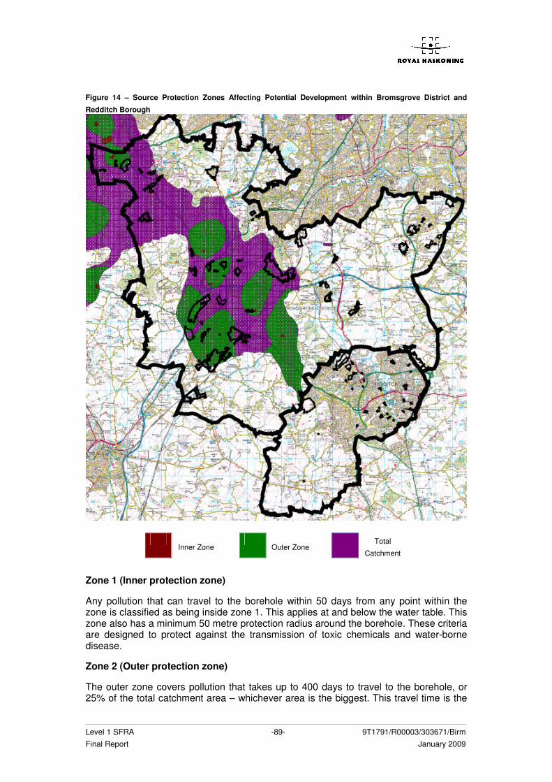
Level 1 SFRA -89- 9T1791/R00003/303671/Birm Final Report January 2009
Figure 14 – Source Protection Zones Affecting Potential Development within Bromsgrove District and
Redditch Borough
Inner Zone
Outer Zone Total
Catchment
Zone 1 (Inner protection zone)
Any pollution that can travel to the borehole within 50 days from any point within the zone is classified as being inside zone 1. This applies at and below the water table. This zone also has a minimum 50 metre protection radius around the borehole. These criteria are designed to protect against the transmission of toxic chemicals and water-borne disease.
Zone 2 (Outer protection zone)
The outer zone covers pollution that takes up to 400 days to travel to the borehole, or 25% of the total catchment area – whichever area is the biggest. This travel time is the
Level 1 SFRA -90- 9T1791/R00003/303671/Birm Final Report January 2009
minimum amount of time that we think pollutants need to be diluted, reduced in strength or delayed by the time they reach the borehole.
Zone 3 (Total catchment)
The total catchment is the total area needed to support removal of water from the borehole, and to support any discharge from the borehole.
(Environment Agency website)
Depending upon the proposed catchment and estimated surface water runoff pollutant load, the application of SUDS, especially those based upon infiltration, must be done so with care within areas designated as Source Protection Zones (SPZ). SUDS schemes serving these catchments must fully integrate the management train concept and be lined in the upper stages (i.e. where the pollutant load is likely to be at its highest) in order to minimise the potential for pollutant laden surface water to infiltrate the ground. The management train concept starts with prevention for individual premises and progresses through local source controls to larger downstream site and regional controls. Additional information on the planning, design, construction and operation of SUDS can be found in the CIRIA publication C697, The SUDS Manual, and the associated site handbook C698, both of which can be downloaded from the CIRIA website: www.ciria.org.uk/downloads.htm
4.8.5 Flood Warning and Emergency Planning
New developments should consider the role of flood warning. The Environment Agency operates a National flood warning system for a large number of existing properties currently at risk of flooding in order to enable householders to protect life or take early action to manage the effect of flooding on property. New developments should consider the role of flood warning in managing residual risks although they should not rely solely on them. Section 4.6 discussed the present availability of flood warning and emergency response arrangements within the Borough and District. Developments which include areas likely to flood will need to provide appropriate flood warning and formulate appropriate emergency plans to ensure their safe occupancy in the future. As a minimum, where any such development takes place in flood risk areas it is important that there is adequate passive flood warning in place, with signs highlighting the susceptibility to flooding and clearly signed evacuation routes where necessary.
4.8.6 Residual Risk Management
Flood risk to people and property associated with new developments can be managed but it can never be completely removed; a residual risk will always remain after flood management or mitigation measures have been put in place. Residual risk can be defined as the risk remaining after applying the sequential approach and taking mitigating actions. Local Planning Authorities and developers should always consider residual flood risk issues relating to a development. The potential sources of this residual risk will need to
Level 1 SFRA -91- 9T1791/R00003/303671/Birm Final Report January 2009
be identified in the FRA, along with their potential impacts, and the most significant will have to be mitigated through flood risk management measures. The costs of such measures may be low compared to the damages they avoid and may enhance the value of the development. As with all aspects of development and flood risk, it is best to consider residual flood risk early in the planning process, as measures to manage it may impact on site layout and the extent of developable land. New developments will be expected to show that they do not increase flood risk for up to the 1 in 100 year flood event plus climate change and threat there is no reduction in the storage volume of the floodplain. All development will need to demonstrate that it is safe, over its lifetime. The Environment Agency advise the following:
• Raising finished floor levels 600mm above the 1 in 100 year plus climate change flood event;
• More and Highly vulnerable development will need safe dry access up to the 1 in 100 year event plus climate change; and
• Flood management plans will be required to show access to and from the site during flood conditions.
In addition to the above measures there is also the risk of flooding that can occur in flood events in excess of the 1 in 100 year event and the 1 in 1,000 year extreme flood. New development, particularly more and highly vulnerable uses will need to show that the level of flood risk can be safely managed. Emergency planners and local Resilience Forums should be contacted on whether they can evacuate safely during times of flooding up to and including the extreme flood events. Although flooding cannot be wholly prevented, its impacts can be reduced through good planning and management. Thus it is vital to make the most of opportunities to reduce existing flood risk to communities. For instance, opportunities to re-create and safeguard functional flood plain and washlands and to design more livable developments combining sustainable defences, green/recreational space and increased flood storage should be investigated as early as possible when planning new developments. Residual flood risk management needs to be coordinated with emergency procedures.

Level 1 SFRA -92- 9T1791/R00003/303671/Birm Final Report January 2009
Level 1 SFRA -93- 9T1791/R00003/303671/Birm Final Report January 2009
5 CONCLUSIONS AND RECOMMENDATIONS
5.1 Conclusions
Flooding, is a key issue within Bromsgrove District and Redditch Borough and one that should be considered in all stages of the planning process. Although limited Main River flooding does occur, most notably from the Swans Brook and the Bow Brook in Redditch Borough, surface water and sewer flooding is much more widespread and rapid, resulting in the direct flooding of property and roads or the overtopping of the smaller ordinary watercourses. This is assisted by the topography, geology, farming practices, lack of maintenance and the urbanisation of the catchments. The information and knowledge gathered through this Level 1 SFRA should be used to inform the emerging LDFs and Core Strategies and future flood risk management needs of the Borough and District. It will also provide a sound basis should a future Level 2 SFRA be required. This Level 1 SFRA considers all sources of flooding within the Borough and District based on a desktop study and extensive consultation carried out with the Environment Agency, the Councils, Severn Trent Water, British Waterways and the Highways Agency. It satisfies the requirements for SFRAs and more specifically the amplified guidance given in paragraphs 3.43 to 3.49 of PPS25 Practice Guide Companion for preparing Level 1 SFRAs. The findings of the Level 1 SFRA are given in the form of this report and the accompanying SFRA Flood Zone maps (as per Table D.1 of PPS25) covering the entire Borough and District. These maps provide the basis for the application of Sequential Test. The figures will also be available in a GIS framework on a CD accompanying the final version of this Level 1 SFRA. All the map layers will be available within the GIS and will enable the viewer to zoom the key areas of interest. If the Exception Test is to be applied when identifying the Preferred Options and allocating development sites then the Council may have to carry out a Level 2 SFRA to fully consider the effectiveness and standard of protection provided by the existing flood defences.
5.2 Recommendations
The Sequential Test must be applied by the Councils for all development sites and other sites in accordance with the findings of this report when preparing the emerging LDF documents for the Redditch Borough and Bromsgrove District. The Guidance Note in Appendix D along with the findings of this SFRA, will assist with this process. If the Exception Test is needed, an update of the existing SFRA (including a review of developer guidance) may be necessary in order to meet the requirements of a Level 2 SFRA as defined in PPS25. The Level 2 SFRA would incorporate additional flood risk analysis and include additional guidance for Councils and developers. This would include a more detailed assessment of the risk and consequence of overtopping of the flood defences. The Functional Floodplain for some main, and minor, rivers and watercourses would need mapping during this update. A recommended Scope for a Level 2 SFRA is shown below.
Management of surface runoff from the proposed sites should use a combination of site specific and strategic SUDS measures encouraging ‘source control’ where possible. These measures should be developed with a strategic approach to flood management in mind.
Level 1 SFRA -94- 9T1791/R00003/303671/Birm Final Report January 2009
5.2.1 Level 2 SFRA Scope
Following the guidance provided in PPS25: A Practice Guide, pp52 and the conclusions of this Level 1 SFRA, the following scope is recommended for a Level 2 SFRA for the study area of Bromsgrove District and Redditch Borough:
� Appraisal of the current condition of flood defence infrastructure and the likely future management policy with regards to its maintenance and upgrade (this analysis will be limited within the study area due to the limited number of flood defences) – this will assess the likelihood of defence failure and therefore the requirement for additional infrastructure maintenance during the planning period;
� An appraisal of the probability and consequences of overtopping or failure of the existing flood risk management infrastructure, including an appropriate allowance for climate change. This SFRA has indicated that only the flood defences on the Sugar Brook in Bromsgrove will require additional analysis, relating to Development Site E8 and potentially the Policy Reference development sites located in proximity to the flood defences. None of the other flood defences are located in proximity to the development sites, although this will require further review as part of the Level 2 SFRA;
� Identification of safe access and egress routes to any development located within Flood Zones 2 and 3 during a 100 year flood event;
� Definition and mapping of the functional floodplain in locations next to proposed development sites – this will assist the Councils in undertaking the Sequential and Exception Tests;
� Maps showing the distribution of flood risk across all the Flood Zones from all sources of flooding taking climate change into account. This will require the modelling of watercourses identified as problematic within this Level 1 SFRA and located in proximity to potential development sites to enable accurate execution of the Sequential and Exception Tests. It is recommended that this additional modelling determines the Functional Floodplain, 100 year, 100 year plus climate change, 1000 year and 1000 year plus climate change flood extents on the following watercourses:
Bromsgrove District - the Spadesbourne
Brook - the Battlefield Brook - the Gallows Brook
Redditch Borough - the Batchley Brook - the Red Ditch
� A review of the revised River Arrow model and re-running to account for the 100
year with climate change, 1000 year flood extent and 1000 year with climate change, if not included;
� Investigation into the feasibility of compensatory flood storage in order to ensure that flood risk does not increase as a result of development taking place in the flood plain;
� Guidance on appropriate policies for sites which satisfy parts a) and b) of the Exception Test and requirements to consider at the planning application stage to pass part c) of the Exception Test;
� Guidance of the preparation of FRAs for sites of varying risk across the flood zones, including information about the use of SUDS techniques;
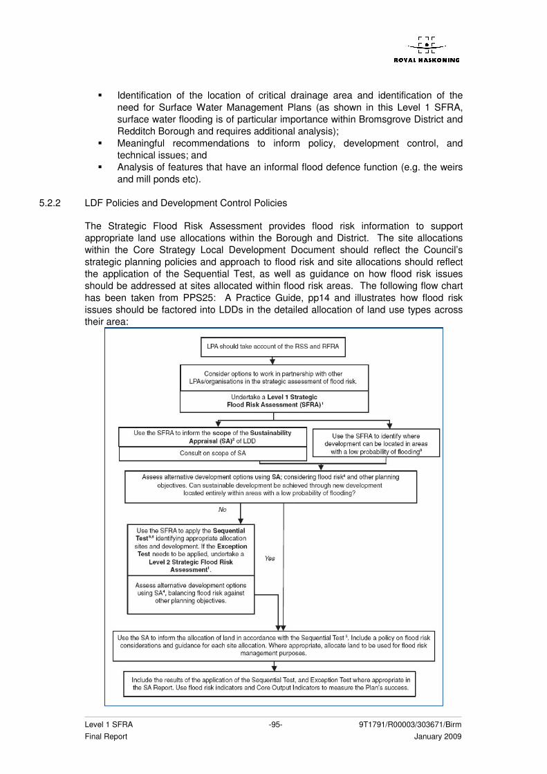
Level 1 SFRA -95- 9T1791/R00003/303671/Birm Final Report January 2009
� Identification of the location of critical drainage area and identification of the need for Surface Water Management Plans (as shown in this Level 1 SFRA, surface water flooding is of particular importance within Bromsgrove District and Redditch Borough and requires additional analysis);
� Meaningful recommendations to inform policy, development control, and technical issues; and
� Analysis of features that have an informal flood defence function (e.g. the weirs and mill ponds etc).
5.2.2 LDF Policies and Development Control Policies
The Strategic Flood Risk Assessment provides flood risk information to support appropriate land use allocations within the Borough and District. The site allocations within the Core Strategy Local Development Document should reflect the Council’s strategic planning policies and approach to flood risk and site allocations should reflect the application of the Sequential Test, as well as guidance on how flood risk issues should be addressed at sites allocated within flood risk areas. The following flow chart has been taken from PPS25: A Practice Guide, pp14 and illustrates how flood risk issues should be factored into LDDs in the detailed allocation of land use types across their area:
Level 1 SFRA -96- 9T1791/R00003/303671/Birm Final Report January 2009
The SFRA provides the baseline information for the Sustainability Appraisal (SA) of LDDs for the scoping and evaluation stages, in addition to providing the evidence base for the application of the Sequential Test and Exception Test in the land use allocation process. Ideally the LPA should demonstrate, as part of the SA, that it has considered a range of options in conjunction with the Flood Zone information from the SFRA and applied Sequential Test and, if necessary, Exception Test. The LDDs should identify the specific flood risk related issues which will need to be addressed for certain site allocations when a planning application is submitted for their development. Suggested local polices for the LDF, which presume that PPS25 is followed, are listed below:
� Development sites should be allocated according to the Sequential, and if necessary Exception tests, as detailed within this report, and evidence must be provided for the reasoning;
� Additional FRAs should be carried out for sites for which Flood Zones are undefined or other sources of flood risk are considered an issue, as recommended within this SFRA;
� Where development is proposed in undefended areas of the floodplain, which lie outside of the functional floodplain it must remain safe without increasing flood risk, and ideally reducing the risk;
� Where development is proposed behind raised flood defences additional analysis will be required as part of a Level 2 SFRA or site specific FRA with regards to the increase in residual risk through loss of flood site storage or the disruption of conveyance routes;
� Application of the flood risk management hierarchy should be used before solutions such as ground raising or the construction of new defences are considered;
� Where appropriate the LDF should allocated green corridors along the lines of watercourses;
� Paving of gardens or other areas should be controlled and SUDS would be required to drain these wherever practicable;
� Appropriate SUDS techniques should be considered for all new developments to ensure that flood risk is not increased elsewhere. For Greenfield sites, this will require a calculation of Greenfield runoff rates;
� Any new development on a site should give full consideration to improving existing culverts by either opening them up, or if this is not practicable, then the existing culvert should be improved in capacity;
� New developments that have watercourses running through them should have a comprehensive plan for managing and maintaining the watercourse; and
� Where practicable flood risk should be reduced by increasing flood storage, improving flood flow routes and/or removing existing obstructions to flow.
Level 1 SFRA -97- 9T1791/R00003/303671/Birm Final Report January 2009
6 REFERENCES
1. Bromsgrove District and Redditch Borough Water Cycle Strategy, Royal Haskoning, 2008
2. West Midlands Regional Spatial Strategy (WRMSS) Phase Two Revision Draft: Preferred Option, West Midlands Regional Assembly, 2007
3. West Midlands Regional Spatial Strategy (WRMSS) Phase Two Revision Draft: West Midlands Regional Assembly, 2008
4. The Tame, Anker and Mease Catchment Abstraction Management Strategy, Environment Agency, 2007
5. The Warwickshire Avon Catchment Abstraction Management Strategy, Environment Agency, 2006
6. The Worcestershire Middle Severn Catchment Abstraction Management Strategy, Environment Agency, 2006
7. Bromsgrove District Local Plan, Bromsgrove District Council, 2004
8. Issues and Options, Full Version, Bromsgrove District Council, 2005
9. Local Development Framework, Core Strategy, Bromsgrove District Council
10. Borough of Redditch Local Development Framework, Local Plan No. 3, Redditch Borough Council, 2006
11. Core Strategy Issues and Options Document Development Plan, Redditch Borough Council, 2008
12. Redditch Borough Council Policy Statement on Flood Defence
13. NATCON 257 Flood Risk Mapping: Bow Brook, Elcock’s Brook and Shell Brook Final Report, Environment Agency, 2003
14. River Salwarpe Strategic Flood Risk Mapping Final Report, Environment Agency Lower Severn, 2007
15. Rivers Arrow and Alne Flood Risk Mapping Investigation, Final Report, Environment Agency Midlands Region, 2003
16. Communities and Local Government, 2006, Planning Policy Statement 25: Development and Flood Risk
17. Development and Flood Risk a Practice Guide Companion to PPS25, 2008
18. EA ‘High Level Target 3: Emergency Exercises and Emergency Plans’ Report to DEFRA April 2005
Level 1 SFRA -98- 9T1791/R00003/303671/Birm Final Report January 2009
19. Delivery of Making Space for Water, HA6 Catchment Scale Land-Use Management, HA7 Land Management Practices: Identification of Catchments Sensitive to Land Use Change’ EA, January 2008
20. ‘The Impact of Upland Land Management on Flooding: insights from a multiscale experimental and modelling programme’ Jackson et al, 2008, Journal of Flood Risk Management 1 pp71 - 80
21. River Severn Catchment Flood Management Plan: Consultation Draft Plan, Environment Agency, 2008

APPENDICES


Appendix A Figures


Appendix B Historic Flooding Tables


Appendix C Hydraulic Models

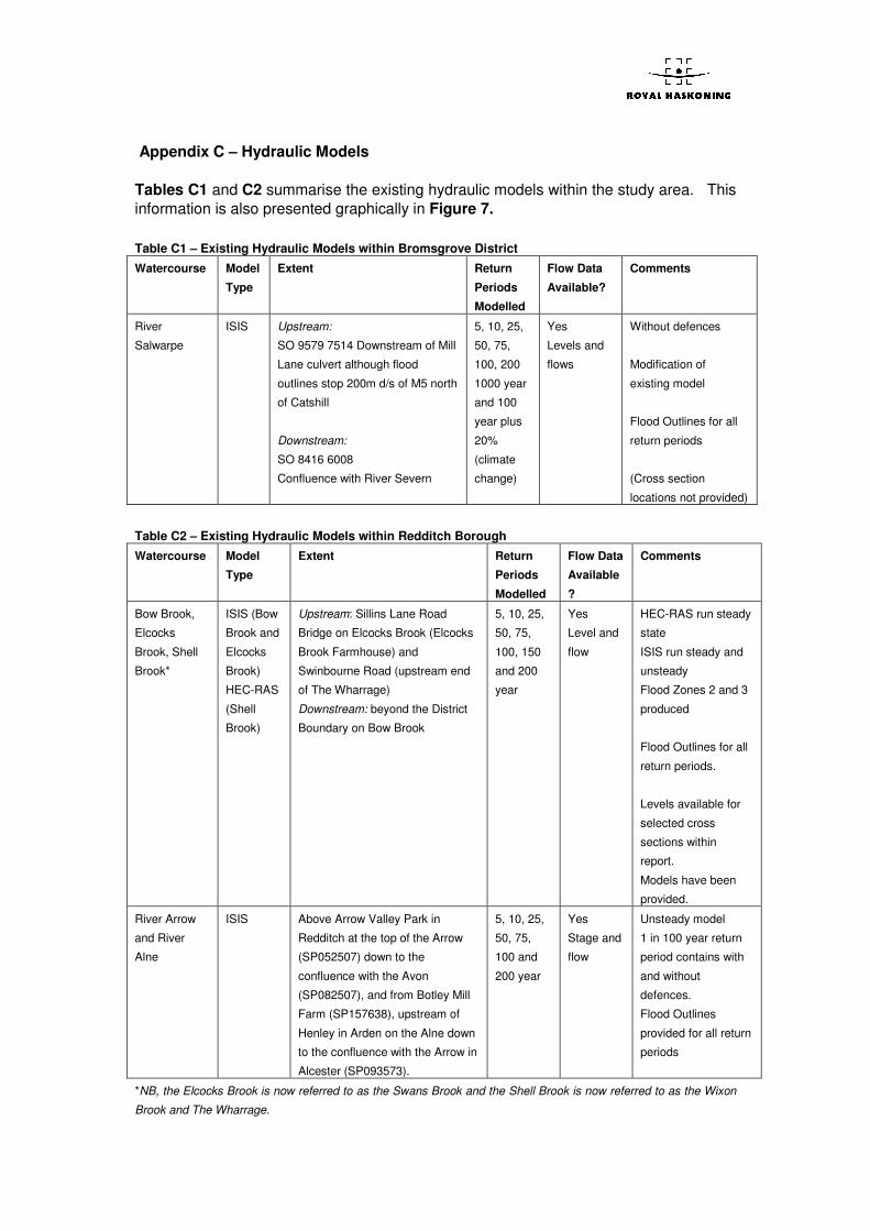
Appendix C – Hydraulic Models Tables C1 and C2 summarise the existing hydraulic models within the study area. This information is also presented graphically in Figure 7. Table C1 – Existing Hydraulic Models within Bromsgrove District
Watercourse Model
Type
Extent Return
Periods
Modelled
Flow Data
Available?
Comments
River
Salwarpe
ISIS Upstream:
SO 9579 7514 Downstream of Mill
Lane culvert although flood
outlines stop 200m d/s of M5 north
of Catshill
Downstream:
SO 8416 6008
Confluence with River Severn
5, 10, 25,
50, 75,
100, 200
1000 year
and 100
year plus
20%
(climate
change)
Yes
Levels and
flows
Without defences
Modification of
existing model
Flood Outlines for all
return periods
(Cross section
locations not provided)
Table C2 – Existing Hydraulic Models within Redditch Borough
Watercourse Model
Type
Extent Return
Periods
Modelled
Flow Data
Available
?
Comments
Bow Brook,
Elcocks
Brook, Shell
Brook*
ISIS (Bow
Brook and
Elcocks
Brook)
HEC-RAS
(Shell
Brook)
Upstream: Sillins Lane Road
Bridge on Elcocks Brook (Elcocks
Brook Farmhouse) and
Swinbourne Road (upstream end
of The Wharrage)
Downstream: beyond the District
Boundary on Bow Brook
5, 10, 25,
50, 75,
100, 150
and 200
year
Yes
Level and
flow
HEC-RAS run steady
state
ISIS run steady and
unsteady
Flood Zones 2 and 3
produced
Flood Outlines for all
return periods.
Levels available for
selected cross
sections within
report.
Models have been
provided.
River Arrow
and River
Alne
ISIS Above Arrow Valley Park in
Redditch at the top of the Arrow
(SP052507) down to the
confluence with the Avon
(SP082507), and from Botley Mill
Farm (SP157638), upstream of
Henley in Arden on the Alne down
to the confluence with the Arrow in
Alcester (SP093573).
5, 10, 25,
50, 75,
100 and
200 year
Yes
Stage and
flow
Unsteady model
1 in 100 year return
period contains with
and without
defences.
Flood Outlines
provided for all return
periods
*NB, the Elcocks Brook is now referred to as the Swans Brook and the Shell Brook is now referred to as the Wixon
Brook and The Wharrage.


Appendix D Guidance


Appendix E Data Register

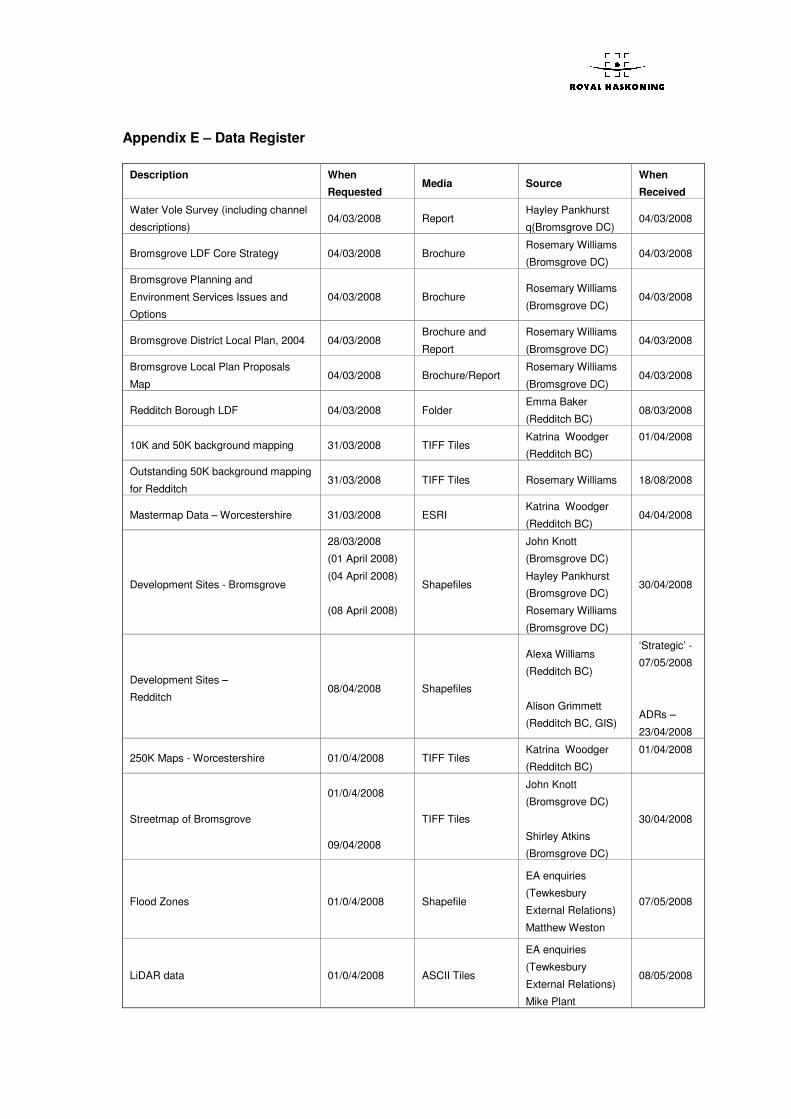
Appendix E – Data Register
Description
When
Requested Media Source
When
Received
Water Vole Survey (including channel
descriptions) 04/03/2008 Report
Hayley Pankhurst
q(Bromsgrove DC) 04/03/2008
Bromsgrove LDF Core Strategy 04/03/2008 Brochure Rosemary Williams
(Bromsgrove DC) 04/03/2008
Bromsgrove Planning and
Environment Services Issues and
Options
04/03/2008 Brochure Rosemary Williams
(Bromsgrove DC) 04/03/2008
Bromsgrove District Local Plan, 2004 04/03/2008 Brochure and
Report
Rosemary Williams
(Bromsgrove DC) 04/03/2008
Bromsgrove Local Plan Proposals
Map 04/03/2008 Brochure/Report
Rosemary Williams
(Bromsgrove DC) 04/03/2008
Redditch Borough LDF 04/03/2008 Folder Emma Baker
(Redditch BC) 08/03/2008
10K and 50K background mapping 31/03/2008 TIFF Tiles Katrina Woodger
(Redditch BC)
01/04/2008
Outstanding 50K background mapping
for Redditch 31/03/2008 TIFF Tiles Rosemary Williams 18/08/2008
Mastermap Data – Worcestershire 31/03/2008 ESRI Katrina Woodger
(Redditch BC) 04/04/2008
Development Sites - Bromsgrove
28/03/2008
(01 April 2008)
(04 April 2008)
(08 April 2008)
Shapefiles
John Knott
(Bromsgrove DC)
Hayley Pankhurst
(Bromsgrove DC)
Rosemary Williams
(Bromsgrove DC)
30/04/2008
Development Sites –
Redditch 08/04/2008 Shapefiles
Alexa Williams
(Redditch BC)
Alison Grimmett
(Redditch BC, GIS)
‘Strategic’ -
07/05/2008
ADRs –
23/04/2008
250K Maps - Worcestershire 01/0/4/2008 TIFF Tiles Katrina Woodger
(Redditch BC)
01/04/2008
Streetmap of Bromsgrove
01/0/4/2008
09/04/2008
TIFF Tiles
John Knott
(Bromsgrove DC)
Shirley Atkins
(Bromsgrove DC)
30/04/2008
Flood Zones 01/0/4/2008 Shapefile
EA enquiries
(Tewkesbury
External Relations)
Matthew Weston
07/05/2008
LiDAR data 01/0/4/2008 ASCII Tiles
EA enquiries
(Tewkesbury
External Relations)
Mike Plant
08/05/2008
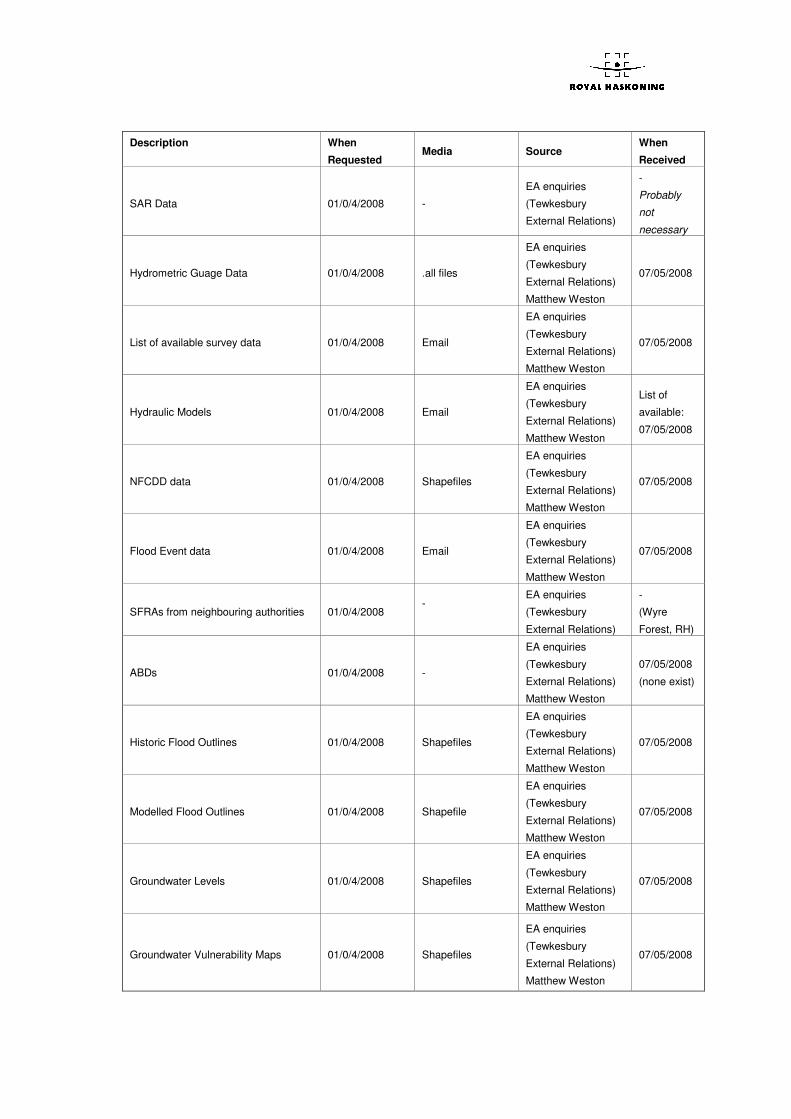
Description
When
Requested Media Source
When
Received
SAR Data 01/0/4/2008 -
EA enquiries
(Tewkesbury
External Relations)
-
Probably
not
necessary
Hydrometric Guage Data 01/0/4/2008 .all files
EA enquiries
(Tewkesbury
External Relations)
Matthew Weston
07/05/2008
List of available survey data 01/0/4/2008 Email
EA enquiries
(Tewkesbury
External Relations)
Matthew Weston
07/05/2008
Hydraulic Models 01/0/4/2008 Email
EA enquiries
(Tewkesbury
External Relations)
Matthew Weston
List of
available:
07/05/2008
NFCDD data 01/0/4/2008 Shapefiles
EA enquiries
(Tewkesbury
External Relations)
Matthew Weston
07/05/2008
Flood Event data 01/0/4/2008 Email
EA enquiries
(Tewkesbury
External Relations)
Matthew Weston
07/05/2008
SFRAs from neighbouring authorities 01/0/4/2008 -
EA enquiries
(Tewkesbury
External Relations)
-
(Wyre
Forest, RH)
ABDs 01/0/4/2008 -
EA enquiries
(Tewkesbury
External Relations)
Matthew Weston
07/05/2008
(none exist)
Historic Flood Outlines 01/0/4/2008 Shapefiles
EA enquiries
(Tewkesbury
External Relations)
Matthew Weston
07/05/2008
Modelled Flood Outlines 01/0/4/2008 Shapefile
EA enquiries
(Tewkesbury
External Relations)
Matthew Weston
07/05/2008
Groundwater Levels 01/0/4/2008 Shapefiles
EA enquiries
(Tewkesbury
External Relations)
Matthew Weston
07/05/2008
Groundwater Vulnerability Maps 01/0/4/2008 Shapefiles
EA enquiries
(Tewkesbury
External Relations)
Matthew Weston
07/05/2008
Description
When
Requested Media Source
When
Received
Groundwater Source Protection Zones 01/0/4/2008 Shapefiles
EA enquiries
(Tewkesbury
External Relations)
Matthew Weston
07/05/2008
River Quality Data (GQA and RQO) 01/0/4/2008 Shapefile
EA enquiries
(Tewkesbury
External Relations)
Matthew Weston
07/05/2008
CFMPs
River Severn 01/0/4/2008 PDF
Internet – EA
Website 01/04/2008
CAMS
Warwickshire Avon CAMS
Worcestershire Middle Severn CAMS
Tame, Anker and Mease CAMS
01/0/4/2008 PDF Internet – EA
Website 01/04/2008
Watercourse and Flooding Data –
Redditch 04/04/2008
Excel
Spreadsheet, MS
Word Document &
Clive Wilson 14/04/2008
Highways Flooding Records 04/04/2008 Excel
Spreadsheet
David Aitchison
(Area 9) Amey
Mouchel - email
17/04/2008
Worcestershire County Plan 07/04/2008 PDF Document Online 07/04/2008
Making Space for Water, The Role of
Land Use and Land Management in
Delivering Flood Risk Management,
Jan 2008
07/04/2008 PDF Document Online 07/04/2008
Sewer Flooding Records 08/04/2008 Excel
Spreadsheet
Andrew Marsh &
Martin Young
(Severn Trent
Water)
25/06/2008
Background Information about
Bromsgrove Drainage 09/04/2008 Conversation
John Bailey
(Bromsgrove DC
Land Drainage)
09/04/2008
Canal Flooding Records 10/04/2008 Letter Sally Phipps (British
Waterways) - letter 25/04/2008
Bromsgrove Housing Capacity Study,
2004 10/04/2008 PDF Document Online 10/04/2008
Worcestershire County Emergency
Flood Plan 16/04/2008 PDF Document Online 16/04/2008
5 year housing land supply in Redditch
Borough 18/04/2008 PDF Document Online 18/04/2008
Appendix 2, Worcestershire RSS 18/04/2008 PDF Document Online 18/04/2008
Shell Brook Survey Data, 2002 07/05/2008 CD
EA – Matthew
Weston
(received from EA
Barnaby Ellis)
04/06/2008
Description
When
Requested Media Source
When
Received
Bow Brook Survey Data and Report,
2002 07/05/2008 CD
EA – Matthew
Weston
(received from EA
Barnaby Ellis)
04/06/2008
Elcocks Brook Survey Data, 2002 07/05/2008 CD
EA – Matthew
Weston
(received from EA
Barnaby Ellis)
04/06/2008
NATCON 257 – Bow/Shell & Ecocks
Brook Models, 2004 07/05/2008 CD
EA – Matthew
Weston
(received from EA
Barnaby Ellis)
04/06/2008
Arrow Alne Section 105, FRM Study –
Annex 3, Digital Deliverables, 2003 07/05/2008 CD
EA – Matthew
Weston
(received from EA
Barnaby Ellis)
04/06/2008
Copy of River Arrow and Alne iSIS test
model, 2005 07/05/2008 CD
EA – Matthew
Weston
(received from EA
Barnaby Ellis)
04/06/2008
Arrow and Alne Flood Risk Mapping
Investigation, 2003 07/05/2008 CD
EA – Matthew
Weston
(received from EA
Barnaby Ellis)
04/06/2008
Flood Resilience Analysis, Redditch 02/06/2008 Document RBC – Clive Wilson 02/06/2008
Watercourse Names 02/06/2008 Hardcopy map RBC – Clive Wilson 02/06/2008
Culvert locations, inspection times and
STW balancing ponds 02/06/2008
Excel spreadsheet
and hardcopy map RBC – Clive Wilson 02/06/2008
Batchley Brook Flood Outline 2007 02/06/2008 Hardcopy with
photos RBC – Clive Wilson 02/06/2008
Catchment outlines – Redditch 02/06/2008 Hardcopy Map RBC – Clive Wilson 02/06/2008
Historical Flooding Records from BHS
Chronology of British Hydrological
Events
04/06/2008 Electronic Internet 04/06/2008
Redditch Borough Council Policy
Statement on Flood Defence, Dec
2005
10/06/2008 PDF Internet 10/06/2008
Environment Agency High Level
Target 3: Emergency Exercises and
Emergency Plans’ Report to DEFRA
April 2005
10/05/2008 PDF Internet 10/05/2008
CEH National River Flow Archive Data
http://www.ceh.ac.uk/data/nrfa/catchm
ent_spatial_information.html
River Arrow, River Salwarpe, River
Cole and Bow Brook
10/05/2008 Electronic figures
and text Internet 10/05/2008
Description
When
Requested Media Source
When
Received
West Midlands Regional Spatial
Strategy (RSS 11) The Impact of
Housing Growth on Water Quality and
Waste Water Infrastructure
10/05/2008 PDF Report Internet 10/05/2008
East Staffordshire Water, Water
Resource Management Plan and Non-
Technical Summary
12/05/2008 PDF Report Internet 12/05/2008
Severn Trent Water, Water Resource
Management Plan and Non-Technical
Summary
12/05/2008 PDF Report Internet 12/05/2008
South Staffordshire Water, Strategic
Direction Statement 12/05/2008 PDF Report Internet 12/05/2008
Severn Trent Water, Strategic
Direction Statement 12/05/2008 PDF Report Internet 12/05/2008
South Staffordshire Water SEA Report 12/05/2008 PDF Document South Staffordshire
Water Website 12/05/2008
Focus on Water, Dec 2007 12/05/2008 PDF Document Severn Trent Water
Website 12/05/2008
Schematics and Information regarding
sewer networks, water supply
networks, sewage treatment works
capacity etc from Severn Trent Water.
13/06/2008 Partial (Email) Andrew Marsh
Severn Trent Water 04/07/2008
Schematics of water supply network
from South Staffordshire Water 13/06/2008
Excel
Spreadsheet
Dave Martin
South Staffordshire
Water
02/07/2008
Bromsgrove District Council, Land
Availability Housing and Employment
Surveys
19/06/2008 Hard Copy Report Rosemary Williams,
Bromsgrove DC 24/06/2008
River Salwarpe Model 11/07/2008 CD Sue Munns (via
Sumi Lai) 18/07/2008
Information regarding groundwater
flooding 17/07/2008
Telephone
conversation
Alistair Brodey
(Fradley) re
Redditch
Tony Jenkins
(Shrewsbury) re
Bromsgrove
17/07/2008
22/07/2008
Flood Watch Areas – West
Warwickshire (Redditch) 19/06/2008 GIS Shapefile EA (Wendy Rees) 16/07/2008
Statement regarding standard and
condition of flood defences through
Redditch
19/06/2008 Email [Peter Clarke via
Tina Scott] 15/08/2008
Statement on viability of rainfall
warnings in Redditch 19/06/2008 Email
[Peter Coxhill via
Tina Scott] 15/08/2008
Corrections to JFLOW flood zones 19/06/2008 [Niall Hall via Tina
Scott]
Not
Available
Description
When
Requested Media Source
When
Received
River Salwarpe FRA (JBA) 10/07/2008 Paul Flynn Not
Available
Gallows Brook FRAs 10/07/2008 Paul Flynn Not
Available
Bromsgrove models and/or surveys 10/07/2008 Paul Flynn Not
Available
SAR data 10/07/2008 Paul Flynn Not
Available
Flood Watch Shapefile - Bromsgrove 10/07/2008 Paul Flynn 24/07/2008
Flood Outlines for 25yr and 100yr +CC
for River Salwarpe 23/07/2008 Email GIS outlines
(Sue Munns)
Peter Restorick 20/08/2008
Historical Flooding Information Map and Text John Bailey 05/08/2008
Sewer Locations and problems in
Bromsgrove 05/08/2008 Map and Text John Bailey 12/08/2008
Sewer Locations and problems in
Redditch 12/08/2008 Map and Email Clive Wilson 14/08/2008