Embed Size (px)
Citation preview

Broxtowe Borough CouncilPreferred Approachto Site Allocations (Green Belt Review)ConsultationFebruary 2015

Contents Introduction ...................................................................................................................................... 5
Table 1 – Core Strategy Housing Numbers .................................................................................. 5
Table 2 – Existing Land Availability reported in the 2013/14 Broxtowe SHLAA............................ 6
The Assessment Framework ........................................................................................................ 7
Figure 1: Assessment Criteria ...................................................................................................... 7
Figure 2: Assessment Matrix ....................................................................................................... 8
Awsworth ....................................................................................................................................... 11
Zone Assessment Summary: ..................................................................................................... 13
Zone 1: East of Awsworth........................................................................................................... 15
Zone 2: West of Awsworth .......................................................................................................... 17
Brinsley .......................................................................................................................................... 21
Zone Assessment Summary: ..................................................................................................... 23
Zone 3: North East of Brinsley .................................................................................................... 25
Zone 4: South East of Brinsley ................................................................................................... 27
Zone 5: South West of Brinsley .................................................................................................. 29
Zone 6: North West of Brinsley ................................................................................................... 30
Eastwood ....................................................................................................................................... 32
Zone Assessment Summary: ..................................................................................................... 34
Zone 7: South East of A610 ....................................................................................................... 36
Zone 8: South West of A610 ...................................................................................................... 38
Zone 9: West of Mansfield Road ................................................................................................ 40
Zone 10: East of Mansfield Road Eastwood ............................................................................... 42
Zone 11: Northwest of Engine Lane ........................................................................................... 45
Zone 12:North northeast of Eastwood ........................................................................................ 47
Zone 13: East Northeast of Eastwood ........................................................................................ 49
Zone 14: East of Eastwood ........................................................................................................ 51
Kimberley ....................................................................................................................................... 53
Kimberley Assessment Summary: .............................................................................................. 55
Zone 15: North of Gilt Hill ........................................................................................................... 57
Zone 16: North of High Spania ................................................................................................... 59
Zone 17: East of Main Road ....................................................................................................... 61
Zone 18: Vicinity of Temple Lake ............................................................................................... 63
Zone 19: East of Park Avenue/ Knowle Lane ............................................................................. 64
Zone 20: South of Church Hill & High Street .............................................................................. 66
Zone 21: West of Swingate ........................................................................................................ 68
2

Main Built Up Area ......................................................................................................................... 70
Main Built up Area Assessment Summary: ................................................................................ 72
Zone 22: West of Hucknall ......................................................................................................... 79
Zone 23: Area between Long Lane and dismantled Railway line adjacent to Blenheim Industrial estate.......................................................................................................................................... 81
Zone 24: Area between Nottingham Road Nuthall and Long Lane ............................................ 84
Zone 25: Land between Nottingham Business Park and Nottingham Road Nuthall ................... 86
Zone 26: Land in Vicinity of Strelley Village ................................................................................ 89
Zone 27: Trowell Moor (between Strelley and Nottingham Road) .............................................. 91
Zone 28: Land between Nottingham Road & Railway Line ........................................................ 93
Zone 29: North of Bramcote Ridge/Moor Farm Lane up to Railway ........................................... 96
Zone 30: Bramcote Ridge/Hills ................................................................................................... 98
Zone 31: West of Coventry Lane .............................................................................................. 101
Zone 32: North West of Field Farm (A609) ............................................................................... 103
Zone 33: Between Moorbridge Lane and the M1 ..................................................................... 106
Zone 34: Between Thorpe Close and Moorbridge Lane ........................................................... 108
Zone 35: West Stapleford (south) ............................................................................................. 110
Zone 36: Hill Top Farm ............................................................................................................. 113
Zone 37: North of Common Lane Bramcote ............................................................................. 115
Zone 38: Land East of the A52 North of Wheatgrass Farm/ South of Common Lane .............. 117
Zone 39: East of Toton Lane – North of the Tram line ............................................................ 118
Zone 40: East of Toton Lane – South of the Tram Line/ Park & Ride ....................................... 120
Zone 41: West of Toton Lane ................................................................................................... 122
Zone 42: Toton Sidings ............................................................................................................ 126
Zone 43: Adjacent Chilwell Retail Park .................................................................................... 129
Zone 44: Attenborough Nature Reserve ................................................................................... 132
Zone 45: South of Beeston Rylands ......................................................................................... 134
Trowell ......................................................................................................................................... 136
Trowell Assessment Summary: ................................................................................................ 138
Zone 46: North of Trowell ......................................................................................................... 139
Zone 47: East of Trowell.......................................................................................................... 141
Zone 48: South West Trowell ................................................................................................... 143
Zone 49: West of Trowell.......................................................................................................... 145
Appendix A: Toton Strategic Location for Growth ........................................................................ 147
Proposed new development within the Strategic Location for growth ...................................... 147
West of Toton/ Stapleford Lane ................................................................................................ 147
East of Toton/ Stapleford Lane (south of the tram line) ............................................................ 147
3

Appendix B: Cross Boundary Assessments with Ashfield ............................................................ 150
Land between Brinsley and Underwood incorporating Broxtowe Zone 3 and Ashfield Zone U04 ................................................................................................................................................. 153
Land West of Hucknall incorporating Broxtowe Zone 22 and Ashfield Zone H08..................... 155
Land between Hucknall and Bulwell incorporating Broxtowe Zone 23 and Ashfield Zone H07 157
Appendix C: Cross Boundary Assessments with Nottingham City ............................................... 159
Land between Nottngham Road Nuthall, Long Lane and Sellers Wood Drive West incorporating Broxtowe Zone 24 and Nottingham City Zone 1b ..................................................................... 161
Land West of A6002 incorporating Broxtowe Zone 26 and Nottingham City Zone 2a .............. 163
Land at Trowell Moor adjacent to Bilborough in Nottingham incorporating Broxtowe Zone 27 and Nottingham City Zone 2b .......................................................................................................... 165
Land between Beeston Rylands, Attenborough and Clifton incorporating Broxtowe Zone 45 and Nottingham City Zone 3a .......................................................................................................... 167
Appendix D: List of Questions ...................................................................................................... 169
4

Introduction The purpose of this document is to seek views on the potential Green Belt boundary changes to provide for the site specific allocations that will follow.
Please read the commentary in the various sections of the discussion document which make more detailed suggestions about how any housing allocation would relate to other potential ‘restrictive’ designations within these areas. These can be viewed on the following pages of this discussion document-
Awsworth – page 11
Brinsley – page 21
Eastwood – page 32
Kimberley – page 53
Main Built up area of Nottingham – page 70
This consultation will assist with the preparation of the Site Allocations part of the Broxtowe Part 2 Local Plan. Part 1 of the Local Plan is the Core Strategy which was adopted in September 2014 and set overall housing targets for the Borough. These are in Policy 2 of the Core Strategy and are listed with dwelling requirements below. The settlements of Awsworth, Brinsley, Eastwood and Kimberley contain ‘up to’ figures and the main built up area is a minimum figure. The consultation includes potential development within the HS2/Toton Strategic Location for Growth with details in Appendix A and Cross Boundary Assessments in Appendices B and C with Ashfield and Nottingham Councils.
Table 1 – Core Strategy Housing Numbers Awsworth 350 Brinsley 150 Eastwood 1250 Kimberley 600 Main Built up Area of Nottingham 3800 Policy 3 of the Core Strategy sets out the approach to the Green Belt in Broxtowe, Gedling and Nottingham. It (1) maintains the principle of the Green Belt, (2) confirms a recasting of the Green Belt to remove Field Farm, and (3) sets out the approach to Green Belt review. The latter provides for a sequential approach looking for sustainable urban sites first and, if insufficient urban sites are available (and the SHLAA indicates that this is the case with a summary in the table below), then specifying the steps that will be taken in reviewing Green Belt. The Core Strategy is available to view on the Council’s website.
It is not suggested that all of the land within the areas consulted upon will be developed for housing. The maps in the consultation document show the percentage of the proposed areas that will need to be developed based on the current availability of urban sites.
5
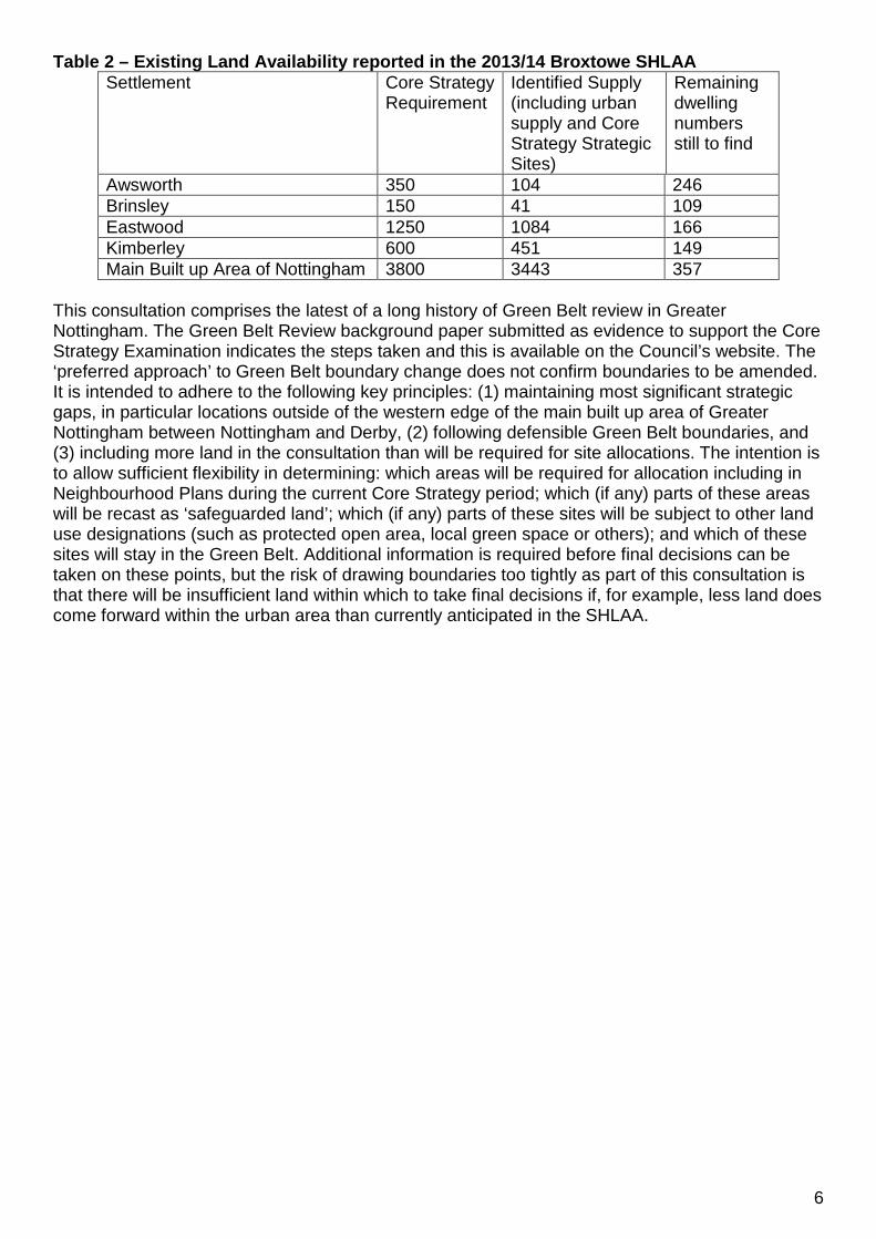
Table 2 – Existing Land Availability reported in the 2013/14 Broxtowe SHLAA Settlement Core Strategy
Requirement Identified Supply (including urban supply and Core Strategy Strategic Sites)
Remaining dwelling numbers still to find
Awsworth 350 104 246 Brinsley 150 41 109 Eastwood 1250 1084 166 Kimberley 600 451 149 Main Built up Area of Nottingham 3800 3443 357
This consultation comprises the latest of a long history of Green Belt review in Greater Nottingham. The Green Belt Review background paper submitted as evidence to support the Core Strategy Examination indicates the steps taken and this is available on the Council’s website. The ‘preferred approach’ to Green Belt boundary change does not confirm boundaries to be amended. It is intended to adhere to the following key principles: (1) maintaining most significant strategic gaps, in particular locations outside of the western edge of the main built up area of Greater Nottingham between Nottingham and Derby, (2) following defensible Green Belt boundaries, and (3) including more land in the consultation than will be required for site allocations. The intention is to allow sufficient flexibility in determining: which areas will be required for allocation including in Neighbourhood Plans during the current Core Strategy period; which (if any) parts of these areas will be recast as ‘safeguarded land’; which (if any) parts of these sites will be subject to other land use designations (such as protected open area, local green space or others); and which of these sites will stay in the Green Belt. Additional information is required before final decisions can be taken on these points, but the risk of drawing boundaries too tightly as part of this consultation is that there will be insufficient land within which to take final decisions if, for example, less land does come forward within the urban area than currently anticipated in the SHLAA.
6

The Assessment Framework Ashfield, Broxtowe, Gedling and Nottingham City Councils have worked jointly to prepare evidence to support their emerging Local Plans within their authorities including a Green Belt Assessment Framework which is available on the website. The appraisals that follow are consistent with this shared framework and the figures below summarise the approach taken.
Figure 1: Assessment Criteria NPPF Purpose of the
Green Belt Assessment Criteria
To check the unrestricted sprawl of large built-up areas1
• The extent to which the site/location is contained by existing built-up areas, and therefore the extent to which development would ‘round off’ these areas.
• The extent to which the site/location is contained by physical features which can act as defensible boundaries, e.g. motorways, roads, railways, watercourses, tree belts, woodlands and field boundaries.
• The extent to which the site/location appears to be visually connected with existing built-up areas, taking into account topographical features.
To prevent neighbouring towns1
merging into one another
• The extent to which development would reduce the size of the gap between settlements.
• The extent to which development would result in the perception of reducing the gap between settlements.
To assist in safeguarding the countryside from encroachment
• The extent to which the site/location contains inappropriate development.
• The extent to which the character of the site/location is ‘urban fringe’ as opposed to ‘open countryside’.
To preserve the setting and special character of historic towns1
• The degree of harm that may be caused to the setting or special character of the settlement, taking into account designated and non-designated heritage assets such as Conservation Areas, Listed Buildings, Historic Parks and Gardens, Scheduled Monuments or important heritage features.
To assist in urban regeneration, by encouraging the recycling of derelict and other urban land
It is considered that all land in the Green Belt assists in urban regeneration to the same extent and therefore no criteria are proposed to distinguish between the values of various sites/locations.
1 Note: Because of the nature and locations of the built-up areas in Ashfield and Greater Nottingham, the Councils consider that this purpose should relate to all settlements (rather than only to ‘large built-up areas’ and ‘towns/historic towns’), as listed in the ‘Accessible Settlements Study for Greater Nottingham February 2010’ (see Appendix 1). Settlements will be considered on the basis of their built form and not on the basis of town or parish boundaries.
7

Figure 2: Assessment Matrix The Matrix provides a grading system for the assessment of sites and will be used at both assessment stages. Higher scoring sites are generally the most important in Green Belt terms. (NB. The term ‘site’ is used for consistency and includes broad locations)
Purpose / Impact Check the unrestricted sprawl of settlements
The site has two or more boundaries adjoining a settlement or rounds off an existing settlement. The site is well contained by strong physical features which can act as defensible boundaries and does not extend over topographical features.
The site has two or more boundaries adjoining a settlement but is not well contained and there are weak or no features to act as defensible boundaries.
The site does not adjoin a settlement, or has only one boundary with a settlement, or forms a long limb into open countryside. There are weak or no features to act as defensible boundaries. The site is visually disconnected from any settlement.
Prevent neighbouring settlements from merging into one another
Development would not reduce the size of the gap between settlements, or would result in only very limited reduction.
Development would result in a moderate reduction in the size of a gap between settlements.
Development would result in a complete or virtually complete merging of settlements.
Assist in safeguarding the countryside from encroachment
The site includes a large amount of existing inappropriate developments which have caused a significant degree of encroachment.
The site includes some existing inappropriate developments which have caused some encroachment.
The site does not have any inappropriate developments and therefore no encroachment.
Preserve the setting and special character of historic settlements
The site will have no adverse impact on one or more conservation areas or designated or non-designated heritage assets associated with settlements.
The site will have a moderate adverse impact on one or more conservation areas or designated or non-designated heritage assets associated with settlements.
The site will have a significant adverse impact on one or more conservation areas or designated or non-designated heritage assets associated with settlements.
Assist in urban regeneration
It is considered that all sites in the Green Belt assist in urban regeneration. This is not considered to be a matter of difference between Green Belt sites and therefore this Green Belt purpose is not scored as part of the Framework.
8

Broxtowe Borough Council Green Belt Review 2015
This is a consultation document and we are requesting your views on it.
Consultation Period: Monday 9th February 2015 to 5:00pm Monday 23rd March 2015 All representations must be submitted within this period and received by the Council by 5:00 pm on Monday 23rd March 2015. Representations can be made electronically via the Council’s web site www.broxtowe.gov.uk/dmpgreenbelt Or written representations can be sent to:- Planning Policy Team, Broxtowe Borough Council, Foster Avenue, Beeston, Nottingham, NG9 1AB. Representation forms are available online at www.broxtowe.gov.uk/dmpgreenbelt Or paper copies are available at the following locations: Broxtowe Borough Council, Foster Avenue, Beeston, Nottingham, NG9 1AB (8.30am to 5.00pm Monday – Thursday and 8.30am to 4.30pm on Fridays); Eastwood Cash Office, 15 Nottingham Road, Eastwood, Nottinghamshire, NG16 3AP (8.45 – 4.30 Monday - Friday) Stapleford Cash Office, Carnegie Civic and Community Centre, Warren Avenue, Stapleford, Nottinghamshire, NG9 8EY (9.30 am – 3.00pm Monday – Friday) Libraries within Broxtowe borough Representation forms can also be requested from the Planning Policy team at the Borough Council Tel: 0115 9173482 E-mailing: [email protected]
In accordance with this framework the Green Belt within Broxtowe has been assessed on the basis of 49 separate ‘zones’. These are shown in the overview map on the following page and relate to the edge of settlements that are outside of the Green Belt.
9

44
27
22
17
28
247
6
1
42
13
5
26
21
23
19
4
12
30
41
16
2
8
25
45
9
38
10
3
3736
46
15
11
31
18
3940
29
14
20
34
32
49
35
47
33
48
43
Green Belt ReviewSettlement Zone Maps Overview
N
© Crown Copyright and database right 2015. Ordnance Survey 100019453You are not permitted to copy, sub-license, distribute or sell any of this data to third parties in any form
02 February 2015
Not To Scale
MapAwsworth
Brinsley
Eastwood
Kimberley
MBA Map 1
MBA Map 2
MBA Map 3
MBA Map 4
MBA Map 5
MBA Map 6
MBA Map 7
MBA Map 8
Trowell

Awsworth

12
© Crown Copyright and database right 2015. Ordnance Survey 100019453 You are not permitted to copy, sub-license, distribute or sell any of this data to third parties in any form.Not To Scale
¯ AwsworthGreen Belt Review
Settlement Zones Map04 February 2015
Borough Boundary
Green Belt
Zones
Defined Zone Boundary

Broxtowe Borough Council Green Belt Review 2015 Zone Assessment Summary: Area Parish Scores for Purpose/ Impact Total
Check the unrestricted sprawl of settlements
Prevent neighbouring settlements from merging into one another
Assist in safeguarding the countryside from encroachment
Preserve the setting and special character of historic settlements
Zone 1: East of Awsworth
Awsworth 4 3 3 3 13
Zone 2: West of Awsworth
Awsworth & Cossall
2 3 2 2 9
Options to both the East and West of Awsworth were previously considered as potential directions for growth in the Tribal report with options to the west to be restricted by the Awsworth bypass. The finding of this review confirms that the west contains a significant defensible boundary in the Awsworth bypass and other potential sites do not. Taking the Green Belt Review as a whole the site to the east of the village (Zone 1) is more important to retain in the Green Belt than the site within the bypass to the west (Zone 2). The site (Zone 2) shown within the bypass contains significantly more than the minimum amount of land required to meet the Awsworth dwelling requirements. It is considered that if a residential allocation is made in this area, it should abut the existing edge of Awsworth, with enhanced planting adjacent to the bypass to minimise the visual impact of any new development. Development should also, if possible, assist in improving Green Infrastructure, walking and cycling links to and across Bennerley Viaduct and access to the soon to be built Ilkeston Station. No vehicle access should be made to the bypass.
13

Consultation Green Belt Boundary Change
© Crown Copyright and database right 2015.Ordnance Survey 100019453
Not to scale
Awsworth
You are not permitted to copy, sub-license, distribute or sell any of this data to third parties in any form.
¯
SITE MAP BOROUGH MAP
LegendConsultation area
Local Plan 2004environmentalconstraint
Green Belt
8.2 of 19.52 ha (approx.42%) of consultation area
would be required for housingbased on existing information
in the SHLAA

Broxtowe Borough Council Green Belt Review 2015 Zone 1: East of Awsworth Purpose / Impact
Score / Assessment Photos
Check the unrestricted sprawl of settlements
The site adjoins the existing urban area of Awsworth on two sides to the east and south. There are a number of field boundaries including reasonably solid boundary treatments but no clear defensible boundary in the direction of Cossall to the south or over open countryside to the east although the land does rise slightly to the east. Development to the South or East would not result in the rounding off of the settlement.
View to the South West looking at the rear of the houses on The Lane.
Prevent neighbouring settlements from merging into one another
Development to the South of Awsworth would have a significant impact on the reduction of the gap between Awsworth and Cossall. The perception of the narrowing of this gap would also be significant because of the topography of the site in that both settlements are located on the Erewash Valley sides in close proximity to each other and there are clear views from the south of Awsworth to Cossall a relatively short distance away. There would also be a reduction in the gap between Awsworth and Kimberley to the north and east.
View to the South towards Ilkeston.
15

Broxtowe Borough Council Green Belt Review 2015 Assist in safeguarding the countryside from encroachment
There are number of urbanising features in the site including dwelling houses, gas infrastructure, low level phone and electricity lines and a cattery but the site as a whole retains the character of ‘open countryside’. Industrial areas inset from the Green Belt are clearly visible and provide an urbanising feel for part of the north of the site. The wind turbine is also clearly visible from many vantage points to the east of the village.
View from crossing point of track and footpath (which leads to Whisgills) looking North towards Ikea at Giltbrook.
Preserve the setting and special character of historic settlements
There are no directly affected heritage assets within Awsworth, albeit development to the south would impact on the setting of the Cossall Conservation Area and Listed Church.
View from footpath South of Babbington Hall towards Cossall showing the spire of Cossall Church at an elevated position.
Assist in urban regeneration
It is considered that all sites in the Green Belt assist in urban regeneration. This is not considered to be a matter of difference between Green Belt sites and therefore this Green Belt purpose is not scored as part of the Framework.
16
Broxtowe Borough Council Green Belt Review 2015 Zone 2: West of Awsworth
Purpose / Impact
Score / Assessment Photos
Check the unrestricted sprawl of settlements
The site adjoins the existing urban area of Awsworth on two sides. The bypass acts as a strong defensible boundary and development within the bypass (adjacent to Awsworth) would round off the settlement. The bypass itself is to some extent screened from the West by tree planting. Land drops down from Awsworth to Erewash Valley (which is the same on the other side of the valley at Ilkeston). The site does form part of a valley side at the higher level however the site does not extend over the valley floor itself.
View from Bennerley Viaduct looking East, tree belt screens Bypass, site assessed is just visible over the trees with existing housing in Awsworth on the valley side beyond this at a higher level.
View from gap in the hedge of White House Farm driveway down towards bypass (with car transporter on bypass) with viaduct and Ilkeston in the distance.
17

Broxtowe Borough Council Green Belt Review 2015 Prevent neighbouring settlements from merging into one another
Development to the West of Awsworth would have a moderate impact on the reduction of the gap between Awsworth and Ilkeston. The perception of the narrowing of this gap would also be an issue because of the topography of the site (in that both settlements are located on the Erewash Valley sides adjacent to each other), Ilkeston is visible from much of Awsworth over the Erewash Valley, although views from Ilkeston would be influenced by the existing bypass and tree screen and the dwellings within Awsworth are at a higher level.
View from existing residential area in Awsworth towards Ilkeston showing viaduct.
18
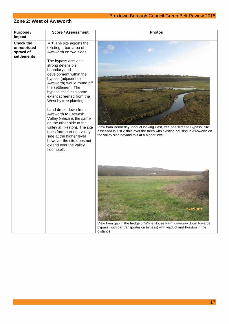
Broxtowe Borough Council Green Belt Review 2015 Assist in safeguarding the countryside from encroachment
The North West of the site inside the bypass includes a large amount of encroachment including residential development, storage containers, a children’s playground and sports pitch. Whilst the final two points are ‘appropriate’ in the Green Belt, it gives the site an urbanising influence rather than ‘open countryside’. To the North West on the far side of the bypass there is a car scrapping yard, animal boarding, a sewage works, a large expanse of hard standing, a disused coal stocking yard and a large wind turbine which, whilst the site does have more of an ‘open’ feel to it, these are all developments which suggest urbanisation/ industrialisation. The West of Awsworth also includes the Bennerley Viaduct itself which is an imposing development in the landscape and to the South West (inside the bypass) there is also a phone mast.
View into ‘The Meadows’ (Green Belt).
Scrap Yard to the West of the Bypass (Green Belt)
View Northeast from Bennerley Viaduct showing the disused coal stocking yard, the large wind turbine, Ikea at Giltbrook and existing housing in Eastwood.
19

Broxtowe Borough Council Green Belt Review 2015
Preserve the setting and special character of historic settlements
Disused Nottingham Canal is a heritage asset which gives the settlement special character; the Canal was used to transport coal from the Erewash valley coal mines. Bennerley Viaduct is Grade II* Listed and is very prominent in the landscape; development of any kind on the West of Awsworth would have some impact on the setting of the Viaduct and would also have an impact on the view of Awsworth from the Viaduct. Parts of the West of Awsworth are also visible from views from the Ilkeston Conservation Area (i.e. Town Centre glimpses into the Countryside). However, the village of Awsworth contains no Conservation Area or heritage assets adjacent to this site. Provided that the bypass is utilised as a defensible boundary then any impact on the Viaduct, Nottingham Canal or setting of Ilkeston Conservation Area is likely to be less than a moderate adverse impact given the screen provided by the bypass, the belt of trees associated with it and any views to Awsworth from the West would be set against the backdrop of clearly visible residential properties at a higher level within the village.
View from Newtons Lane across the Erewash Valley towards Ilkeston showing Nottingham Canal and Bennerley Viaduct.
Assist in urban regeneration
It is considered that all sites in the Green Belt assist in urban regeneration. This is not considered to be a matter of difference between Green Belt sites and therefore this Green Belt purpose is not scored as part of the Framework.
20

Brinsley

6
5
4
3
© Crown Copyright and database right 2015. Ordnance Survey 100019453 You are not permitted to copy, sub-license, distribute or sell any of this data to third parties in any form.Not To Scale
¯ BrinsleyGreen Belt Review
Settlement Zones Map04 February 2015
Borough Boundary
Green Belt
Zones
Defined Zone Boundary

Broxtowe Borough Council Green Belt Review 2015 Zone Assessment Summary: Area Parish Scores for Purpose/ Impact Total
Check the unrestricted sprawl of settlements
Prevent neighbouring settlements from merging into one another
Assist in safeguarding the countryside from encroachment
Preserve the setting and special character of historic settlements
Zone 3: North East of Brinsley
Brinsley 3 4 3 1 11
Zone 4: South East of Brinsley
Brinsley 2 1 3 3 9
Zone 5: South West of Brinsley
Brinsley 4 4 4 4 16
Zone 6: North West of Brinsley
Brinsley 4 2 4 4 14
Options both to the East and West of Brinsley were previously considered as potential directions for growth in the Tribal report. The finding of this review confirms that the east of Church Lane site (Zone 4) contains a significant defensible boundary in the Brinsley Brook, and other potential sites do not. Taking the Green Belt Review as a whole the sites to the North-East (Zone 3), West (Zone 6) and South (Zone 5) of the village are more important to retain in the Green Belt than the site to the east. The site (Zone 4) shown between Church Lane and Brinsley Brook contains significantly more than the minimum amount of land required to meet the Brinsley dwelling requirements. It is considered that if a residential allocation is made in this area, it should front Church Lane and not impinge on the recreation ground to the north or on the Headstocks to the south east. Development should be set well away from Brinsley Brook with the potential for additional tree planting and the enhancement of footpaths and circulation routes through Brinsley Headstocks.
23

Consultation Green Belt Boundary Change
© Crown Copyright and database right 2015.Ordnance Survey 100019453
Not to scale
Brinsley
You are not permitted to copy, sub-license, distribute or sell any of this data to third parties in any form.
¯
SITE MAP BOROUGH MAP
LegendConsultation area
Local Plan 2004environmentalconstraint
Green Belt
3.63 of 28.25 ha (approx.13%) of consultation area
would be required for housingbased on existing information
in the SHLAA

Broxtowe Borough Council Green Belt Review 2015 Zone 3: North East of Brinsley Purpose / Impact Score / Assessment Photos Check the unrestricted sprawl of settlements
Site has three boundaries adjoining the existing settlement of Brinsley. Most of the site is well contained by defensible boundaries with Cordy Lane to South East, Broad Lane to the West and Clumber Avenue to the North West, there is a ridge to the North East however this is not as strong as other boundaries. Part of the site does extend over the ridge.
View from Red Lane to the existing urban area (i.e. along the rear of houses that front onto Broad Lane).
Prevent neighbouring settlements from merging into one another
Development would reduce the gap between Brinsley and Underwood by approximately half. The perception of the reduction of the gap between the two settlements (Brinsley and Underwood) would be significant. When travelling up Cordy Lane to Underwood, there would be very few physical gaps between developments on the main road frontage between the two built up areas.
View across one of very few ‘breaks’ in development along Cordy Lane looking West towards Red Lane
Assist in safeguarding the countryside from encroachment
There are a small number of residential properties located within the Green Belt both on Cordy Lane and Red Lane. Some telegraph poles but largely has the feel of ‘open countryside’ albeit that there is quite a hard edge to the existing built up area of Brinsley.
25

Broxtowe Borough Council Green Belt Review 2015 View from Red Lane towards East
Preserve the setting and special character of historic settlements
The site would have little/no impact on the Conservation Area or Listed Buildings, the site is located at the opposite end of the village to the Conservation Area and its development would be hidden from the Conservation Area and Listed Buildings by the existing built up area.
Assist in urban regeneration
It is considered that all sites in the Green Belt assist in urban regeneration. This is not considered to be a matter of difference between Green Belt sites and therefore this Green Belt purpose is not scored as part of the Framework.
26

Broxtowe Borough Council Green Belt Review 2015 Zone 4: South East of Brinsley Purpose / Impact
Score / Assessment Photos
Check the unrestricted sprawl of settlements
The site adjoins the existing built up area of Brinsley to the North (Cordy Lane), West (Church Lane) and residential development to the South (Mansfield Road). The site is contained by roads on three sides and by Brinsley Brook to the East. From Church Lane the site slopes gently down to the brook sloping back up again to the hillside backdrop beyond. The old spoil tip is prominent in the landscape and the headstocks also have clear views back over the site.
View from Church Lane looking Northeast.
View from Church Lane looking Southeast towards the spoil tip.
Prevent neighbouring settlements from merging into one another
Development would result in a very limited reduction in the gap between Brinsley and other settlements.
27

Broxtowe Borough Council Green Belt Review 2015 Assist in safeguarding the countryside from encroachment
The site contains a small number of residential properties, a care home and resource centre, a few telegraph poles and the Headstocks.
View of the Headstocks looking towards the North West showing the housing on Church Lane in the distance.
Preserve the setting and special character of historic settlements
The Grade II Listed Church of St. James the Great sits adjacent to the site (albeit the entrance door does not face onto Church Lane) and so there will be some impact on the setting of this building. However, the Church itself is contained within its own defined curtilage and there are numerous trees within the curtilage of the Church that would shield the view of the site from the church itself. Development of the site will also have an impact upon the setting of the Headstocks which whilst not Listed does act as an indicator of the historic industrial heritage of the settlement.
View from footpath on Church Lane looking West towards the Church (shown between the trees in the church yard).
Assist in urban regeneration
It is considered that all sites in the Green Belt assist in urban regeneration. This is not considered to be a matter of difference between Green Belt sites and therefore this Green Belt purpose is not scored as part of the Framework.
28

Broxtowe Borough Council Green Belt Review 2015 Zone 5: South West of Brinsley Purpose / Impact
Score / Assessment Photos
Check the unrestricted sprawl of settlements
The site has one boundary with a small part of the village; to split it into smaller sections it could be argued that two sides are contained by roads (Mansfield Road and Stoney Lane) with the River Erewash and the A610 to the South West and a disused railway line to the South East. Development of the site would not ‘round off’ the settlement of Brinsley and would be visually disconnected from the existing settlement. The site does extend over a significant topographical feature.
View from the Headstocks Nature Reserve Car Park towards the South West.
Prevent neighbouring settlements from merging into one another
Development would significantly reduce the gap between Brinsley and Eastwood. It would also have the perception of reducing the gap as the topography of the site would limit the area that was developable and the open feel of the site nearest to the road would be significantly reduced. The land directly to the South of the site has planning permission for employment development and if/when this is to be implemented should this land be removed form the Green Belt it would significantly reduce the gap between the two settlements.
View from ridge South towards Eastwood
Assist in safeguarding the countryside from encroachment
The site includes a small amount of residential properties and farms. There is also a phone mast which is just visible in the woods on the ridge of the hill.
Preserve the setting and special character of historic settlements
The site is adjacent to the Conservation Area with some of the buildings at Manor Farm being located within the Green Belt. The topography of the site would mean that much of its development would have a significant impact upon the Conservation Area as it would be highly visible (see photo at top of page).
Assist in urban regeneration
It is considered that all sites in the Green Belt assist in urban regeneration. This is not considered to be a matter of difference between Green Belt sites and therefore this Green Belt purpose is not scored as part of the Framework.
29

Broxtowe Borough Council Green Belt Review 2015 Zone 6: North West of Brinsley Purpose / Impact
Score / Assessment Photos
Check the unrestricted sprawl of settlements
The site has one boundary that adjoins the settlement. Removing the site from the Green Belt would not round off the settlement There are farm tracks (extending from Hall Lane to Brinsley Hill) which could act as defensible boundaries however using these boundaries would mean that the site would extend over topographical features (the ridge which extends from Hall Farm to The Moor). There is a footpath running along the ridgeline itself, however this is a weak boundary and is very prominent. The site also extends over a valley which runs through the South of the site from South East to South West. There could potentially be some scope for limited development to the rear of the existing housing along Church Walk, Kings Drive and Queens Drive, to be contained by the topographical feature of the valley however the impact on the Conservation Area would have to be investigated.
View from ridge towards Hall Lane Conservation Area and Church Walk (showing valley with rising land behind exiting housing).
Prevent neighbouring settlements from merging into one another
There would be a limited reduction in the gap between Brinsley and Jacksdale.
View Northwest from the ridge showing farm buildings in the middle distance and open countryside in the far distance.
30

Broxtowe Borough Council Green Belt Review 2015 Assist in safeguarding the countryside from encroachment
The site includes some inappropriate development (albeit not very much). There are a handful of residential properties, some wooden telegraph poles and a small number of pylons. The site has a very strong feel of ‘open countryside’ as it’s not contained and certainly from the ridge there is the impression of open fields in all directions (even including towards Brinsley itself as the hills beyond the Headstocks are visible – see photo at top of page 30).
View to North West from North end of Hall Lane showing pylons. Preserve the setting and special character of historic settlements
The Southern portion of the site is a Conservation Area (which includes the converted buildings at Pear Tree Farm which back onto the site itself) and therefore development here would impact upon the historic character of the settlement.
View from the ridge towards the Conservation Area.
Assist in urban regeneration
It is considered that all sites in the Green Belt assist in urban regeneration. This is not considered to be a matter of difference between Green Belt sites and therefore this Green Belt purpose is not scored as part of the Framework.
31

Eastwood

7
8
13
9
12
10
11
14
© Crown Copyright and database right 2015. Ordnance Survey 100019453 You are not permitted to copy, sub-license, distribute or sell any of this data to third parties in any form.Not To Scale
¯ EastwoodGreen Belt Review
Settlement Zones Map04 February 2015
Borough Boundary
Green Belt
Zones
Defined Zone Boundary

Broxtowe Borough Council Green Belt Review 2015 Zone Assessment Summary: Area Parish Scores for Purpose/ Impact Total
Check the unrestricted sprawl of settlements
Prevent neighbouring settlements from merging into one another
Assist in safeguarding the countryside from encroachment
Preserve the setting and special character of historic settlements
Zone 7: South East of A610 Greasley 4 5 2 2 13 Zone 8: South West of A610 Eastwood 3 3 5 3 14 Zone 9: West of Mansfield Road Eastwood 3 3 3 4 13 Zone 10: East of Mansfield Road
Greasley 2 2 3 2 9
Zone 11: Northwest of Engine Lane
Greasley 5 1 4 2 12
Zone 12: North northeast of Eastwood
Greasley 3 1 4 1 9
Zone 13: East Northeast of Eastwood
Greasley 4 2 5 1 12
Zone 14: East of Eastwood Greasley 3 4 4 1 12 Options to both the North and North East of Eastwood were previously considered as potential directions for growth in the Tribal report together with development to the south using the A610 as a defensible boundary (with all of this land already inset from the Green Belt so not considered further as part of this Green Belt Review). The finding of this review confirms that the site (Zone 10) to the north of Eastwood contains a defensible boundary in the disused railway line and other potential sites do not to the same extent. Also, taking the Green Belt Review as a whole, the sites other than the north (Zone 10) and north-east (Zone 12) are more important to retain in the Green Belt. Of these two options (which overall score equally) the site to the north of Eastwood (Zone 10) is considered to be better related to the existing settlement in terms of amounting to a smaller incursion into the countryside and better related to the existing built form of Eastwood. If residential development does take place in this area it is considered that development at the eastern edge of the site may be better related to the existing settlement and will have less of a reduction in the size of the gap between Eastwood and Brinsley. However highway issues would need further investigation and may prove to be less problematic if taking an access directly from Mansfield Road with development on the western part of the site. The selection of this site for consultation is consistent with the recommendation of the Eastwood Advisory Committee.
34
Consultation Green Belt Boundary Change
© Crown Copyright and database right 2015.Ordnance Survey 100019453
Not to scale
Eastwood
You are not permitted to copy, sub-license, distribute or sell any of this data to third parties in any form.
¯
SITE MAP BOROUGH MAP
LegendConsultation area
Local Plan 2004environmentalconstraint
Green Belt
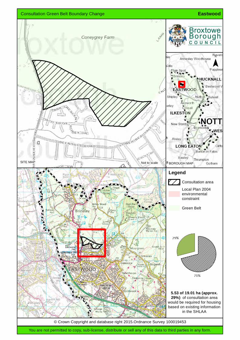
5.53 of 19.01 ha (approx.29%) of consultation area
would be required for housingbased on existing information
in the SHLAA

Broxtowe Borough Council Green Belt Review 2015 Zone 7: South East of A610 Purpose / Impact
Score / Assessment Photos
Check the unrestricted sprawl of settlements
The site has two boundaries; however these are boundaries with the separate settlements of Eastwood and Awsworth. Closely visually connected, however the connections are with separate settlements. Development would not round off either settlement and would not be well contained to the west. The site has no obvious defensible boundaries between the settlements and does not extend over topographical features.
View from road to sewage works, looking east.
Prevent neighbouring settlements from merging into one another
Development would result in a very large reduction in a small gap between settlements.
View from road to sewage works, looking south-west.
Assist in safeguarding the countryside from encroachment
Various inappropriate developments which have caused substantial encroachment and an ‘urban fringe’ character for much of the site, including the sewage works, industrial buildings and some other buildings and structures.
View from road to sewage works, looking south.
36

Broxtowe Borough Council Green Belt Review 2015 Preserve the setting and special character of historic settlements
No significant impact. (Would have some affect the setting of Bennerley Viaduct; however this is within the Green Belt and is distinct from nearby settlements.)
Assist in urban regeneration
It is considered that all sites in the Green Belt assist in urban regeneration. This is not considered to be a matter of difference between Green Belt sites and therefore this Green Belt purpose is not scored as part of the Framework.
37

Broxtowe Borough Council Green Belt Review 2015 Zone 8: South West of A610 Purpose / Impact Score / Assessment Photos
Check the unrestricted sprawl of settlements
The site has one boundary adjoining the existing settlement of Eastwood (to the North the A610 separates the site from the existing area). The site is visually disconnected from the existing settlement of Eastwood. The site would not round off the existing settlement. The site is well contained with the A610 to the Northeast, the Erewash Canal to the West and River Erewash to the Southwest, the track adjacent to the Sports Ground to the Southeast and Anchor Road to the Northwest (albeit that this is not within Broxtowe Borough). The topography of the site is relatively flat and sits at a slightly lower level than the existing urban area of Eastwood.
View along Newmanleys Road (South) with the A610 beyond hedge to the left of the photo.
Prevent neighbouring settlements from merging into one another
Development of the site would moderately reduce the gap between neighbouring settlements (Eastwood and Langley Mill). The perception of the reduction of the gap would be limited however because of the topography of the land and the tree and hedge coverage within and surrounding the site.
Assist in safeguarding the countryside from encroachment
The site does not have any inappropriate development.
View Northwest along public footpath.
38

Broxtowe Borough Council Green Belt Review 2015 Preserve the setting and special character of historic settlements
The Canals (both Nottingham and Erewash) within the site are both heritage assets associated with nearby settlements and the development of this site would have a moderate adverse impact on their setting.
View along disused Nottingham Canal – set within a Local Nature Reserve.
Assist in urban regeneration
It is considered that all sites in the Green Belt assist in urban regeneration. This is not considered to be a matter of difference between Green Belt sites and therefore this Green Belt purpose is not scored as part of the Framework.
39

Broxtowe Borough Council Green Belt Review 2015 Zone 9: West of Mansfield Road Purpose / Impact
Score / Assessment Photos
Check the unrestricted sprawl of settlements
The site has one boundary to the South with the existing urban area albeit that part of the boundary is with an open area with extant permission for employment development and Eastwood Hall which in itself is fairly disconnected with the primary built area of Eastwood as it is intersected with recreational playing fields. The site is contained by Mansfield Road to the East, the existing urban area to the South and the A610 to the West and to some extent the spoil heap to the North.
View from Cockerhouse Road across the land surrounding Hall Farm to the Spoil heap beyond (related to the coal mining in the local vicinity).
Prevent neighbouring settlements from merging into one another
Development in the site would moderately reduce the physical gap between Eastwood and Brinsley. The perception of the reduction in gap may be limited because of the topography of the land (see photo above) and its screening from the main road.
Assist in safeguarding the countryside from encroachment
There are some small roads (albeit they are closed to through traffic) with associated fences and gates that service parts of the land which are inappropriate in the Green Belt. The triangular site that contains Hall Farm has the feel of a residential curtilage because of how it is maintained and its enclosed feel (the plot is surrounded by trees) and so doesn’t have the feel of ‘open countryside’, however the area beyond this is very much ‘open countryside’.
View North East from Cockerhouse Road towards Mansfield Road showing large vegetable plot within curtilage of Hall Farm and the Farm itself beyond.
40

Broxtowe Borough Council Green Belt Review 2015 Preserve the setting and special character of historic settlements
Hall Farm is Grade II Listed and development of the site immediately adjacent to the Farm (the triangular plot) would have an impact upon the setting of the Listed Building. The site itself has the feeling of a farm curtilage with flat grazing land and a vegetable plot. The site also lies adjacent to Eastwood Hall and its development would also have an impact on this.
Photo of Hall Farm Barns (taken from appraisal of recent planning application site visit conducted 14.08.14)
Assist in urban regeneration
It is considered that all sites in the Green Belt assist in urban regeneration. This is not considered to be a matter of difference between Green Belt sites and therefore this Green Belt purpose is not scored as part of the Framework.
41

Broxtowe Borough Council Green Belt Review 2015 Zone 10: East of Mansfield Road Eastwood Purpose / Impact
Score / Assessment Photos
Check the unrestricted sprawl of settlements
The site has two boundaries adjoining the existing settlement of Eastwood. Development of the site south of the disused railway line could round off the existing settlement. Although to the West this site of Mansfield Road feels quite open, development to the East of the site would ‘round off’ the settlement better than development to the West, as it is better connected to the existing built up area of Eastwood. The site is well contained by a dismantled railway line to the North, the existing settlement to the East and the South and Mansfield Road to the West. The topography of the site that is contained within the railway line is largely flat, beyond the railway line the land undulates to the North. The site does not extend over topographical features.
View from footpath at just south of crossing point of the dismantled railway looking East towards Lower Beauvale.
View from footpath accessed at the end of Coach Drive looking West showing existing residential properties along Meadow Close and Thorn Tree Gardens and the spoil heap at the South of Brinsley in the distance.
42

Broxtowe Borough Council Green Belt Review 2015 Prevent neighbouring settlements from merging into one another
Development of the site would result in a limited reduction in the gap between Brinsley and Eastwood. However there would be the perception of a reduced gap between these two settlements (particularly in the West) as it would reduce the amount of ‘open space’ that was visible when travelling along Mansfield Road.
View from the bottom of the footpath (behind the houses on Park Crescent) to the North East (the view that you can glance when travelling up Mansfield Road).
Assist in safeguarding the countryside from encroachment
The site has a small number of residential properties along Mansfield Road and The Grange that are located within the Green Belt.
View taken from adjacent to the Grange looking West towards Mansfield Road.
Preserve the setting and special character of historic settlements
Parts of the site may be visible from the Eastwood Conservation Area, but is separated from it by existing housing. The impact to Listed Buildings to the West of Mansfield Road is likely to be less than moderate given the severing effect of Mansfield Road.
View towards the Conservation Area with the disused railway line in-between.
43

Broxtowe Borough Council Green Belt Review 2015 Assist in urban regeneration
It is considered that all sites in the Green Belt assist in urban regeneration. This is not considered to be a matter of difference between Green Belt sites and therefore this Green Belt purpose is not scored as part of the Framework.
44

Broxtowe Borough Council Green Belt Review 2015 Zone 11: Northwest of Engine Lane Purpose / Impact Score / Assessment Photos Check the unrestricted sprawl of settlements
The site has one boundary adjoining the settlement of Eastwood. Development in this site would form a limb into open countryside and would be visually disconnected from the main built up area of Eastwood due to the topography. The site is not well contained and, whilst Engine Lane to the Southeast and Moorgreen to the Northeast both act as defensible boundaries, to the West there are no defensible boundaries to stop urban sprawl into the open countryside.
View from Moorgreen Southwest towards Industrial area on Engine Lane (i.e. nearest urban area) showing the undulation of the land.
Prevent neighbouring settlements from merging into one another
Development would not reduce the size of the gap between settlements.
Assist in safeguarding the countryside from encroachment
There are a few residential properties around the periphery and some telegraph poles cross the site. However the site does have the feel of ‘open countryside’ and therefore encroachment is very limited.
View from Southwest looking Northeast showing telegraph poles crossing site.
45

Broxtowe Borough Council Green Belt Review 2015 Preserve the setting and special character of historic settlements
Parts of the site may be visible from the Eastwood Conservation Area, but is separated from it by existing housing.
View from Moorgreen looking West.
Assist in urban regeneration
It is considered that all sites in the Green Belt assist in urban regeneration. This is not considered to be a matter of difference between Green Belt sites and therefore this Green Belt purpose is not scored as part of the Framework.
46

Broxtowe Borough Council Green Belt Review 2015 Zone 12:North northeast of Eastwood Purpose / Impact
Score / Assessment Photos
Check the unrestricted sprawl of settlements
There is a full boundary to west/south, partial boundary to north-west, plus ‘ribbon development’ to east / north-east; not visually disconnected. The site is fairly well contained; however development of the whole of this large site could not reasonably be treated as rounding off. Potential defensible boundaries - the B6010, B600 and Engine Lane - would involve releasing a large area. The site does not extend over topographical features.
View from footpath off Beauvale, looking north-west.
Prevent neighbouring settlements from merging into one another
No risk of merging with other settlements.
View from footpath off Beauvale, looking north-east.
Assist in safeguarding the countryside from encroachment
Some buildings around the edges of the site, and some ‘urban fringe’ characteristics due to the prominence of adjacent industrial buildings, however mainly in agricultural use.
View from footpath off Moorgreen, looking north-west (with Engine Lane industrial units in the distance).
47

Broxtowe Borough Council Green Belt Review 2015 Preserve the setting and special character of historic settlements
No impact.
Assist in urban regeneration
It is considered that all sites in the Green Belt assist in urban regeneration. This is not considered to be a matter of difference between Green Belt sites and therefore this Green Belt purpose is not scored as part of the Framework.
48

Broxtowe Borough Council Green Belt Review 2015 Zone 13: East Northeast of Eastwood Purpose / Impact
Score / Assessment Photos
Check the unrestricted sprawl of settlements
There is one boundary with the settlement, plus ‘ribbon development’ at Moorgreen, and not visually disconnected; however the site is not well contained and would not round off the settlement. Potential defensible boundaries - the B600, B6010 and Gilt Brook - would involve releasing a very large area. The site does not extend over topographical features.
View from footpath between Main Street and Moorgreen, looking south-east (towards Gilt Brook valley).
Prevent neighbouring settlements from merging into one another
No risk of merging to the north, however development of the whole site would reduce the gap with Kimberley to the east.
View from footpath off Main Street, looking north-east.
Assist in safeguarding the countryside from encroachment
Some buildings around the periphery, however the large majority of the site is almost entirely agricultural.
View from footpath off Main Street, looking east.
49

Broxtowe Borough Council Green Belt Review 2015 Preserve the setting and special character of historic settlements
No impact. (Greasley Castle, Church etc are within the Green Belt and are distinct from the settlement of Eastwood.)
View from footpath off Moorgreen, looking east (with Greasley Church on the horizon).
Assist in urban regeneration
It is considered that all sites in the Green Belt assist in urban regeneration. This is not considered to be a matter of difference between Green Belt sites and therefore this Green Belt purpose is not scored as part of the Framework.
50

Broxtowe Borough Council Green Belt Review 2015 Zone 14: East of Eastwood Purpose / Impact
Score / Assessment Photos
Check the unrestricted sprawl of settlements
There are two boundaries with the settlement and not visually disconnected, however the site is not well contained and would not round off the settlement. The Gilt Brook could act as a defensible boundary, only if land to the east was not also developed. The site does not extend over topographical features.
View from footpath off Baker Road, looking south.
Prevent neighbouring settlements from merging into one another
Development would result in a large reduction in a small gap between settlements. If land to the east was also developed, the settlements would be merged.
View from footpath off Baker Road, looking south-east (across Gilt Brook valley).
Assist in safeguarding the countryside from encroachment
Predominantly agricultural use, with some equestrian and former motor vehicle uses.
View from footpath off Baker Road, looking east.
51

Broxtowe Borough Council Green Belt Review 2015 Preserve the setting and special character of historic settlements
No impact.
Assist in urban regeneration
It is considered that all sites in the Green Belt assist in urban regeneration. This is not considered to be a matter of difference between Green Belt sites and therefore this Green Belt purpose is not scored as part of the Framework.
52

Kimberley

17
21
19
16
15
18
20
© Crown Copyright and database right 2015. Ordnance Survey 100019453 You are not permitted to copy, sub-license, distribute or sell any of this data to third parties in any form.Not To Scale
¯ KimberleyGreen Belt Review
Settlement Zones Map04 February 2015
Borough Boundary
Green Belt
Zones
Defined Zone Boundary
Broxtowe Borough Council Green Belt Review 2015 Kimberley Assessment Summary: Area Parish Scores for Purpose/ Impact Total
Check the unrestricted sprawl of settlements
Prevent neighbouring settlements from merging into one another
Assist in safeguarding the countryside from encroachment
Preserve the setting and special character of historic settlements
Zone 15: North of Gilt Hill Greasley & Kimberley
3 4 4 1 12
Zone 16: North of High Spania Greasley & Kimberley
3 3 5 1 12
Zone 17: East of Main Road Greasley & Nuthall
3 3 4 1 11
Zone 18: Vicinity of Temple Lake
Nuthall 2 4 3 4 13
Zone 19: East of Park Avenue / Knowle Lane
Nuthall & Kimberley
4 4 5 2 15
Zone 20: South of Church Hill & High Street
Kimberley 2 2 3 2 9
Zone 21: West of Swingate Kimberley 4 5 4 1 14
Options to both the North-West, North East and South of Kimberley were previously considered as potential directions for growth in the Tribal report. Sites to the south would use the A610 as a defensible boundary (with options available within this area). The finding of this review confirms that the site to the south of Kimberley contains a strong defensible boundary in the A610 and other potential sites do not to the same extent. Also, taking the Green Belt Review as a whole all other sites around Kimberley are more important to retain in the Green Belt. If residential development does take place in this site it is considered that development would need to be set back from the A610 due to potential noise and air quality issues and highway access would be an issue requiring further investigation. This is partly consistent with the recommendation of the Kimberley Advisory Committee. One site (SHLAA site 215) is recommended for inclusion and is within this site. When residential allocations are made options will be open to include part of or all of this site and not others, but the site in isolation does not contain defensible Green Belt boundaries. Another recommended site from the Kimberley Advisory Committee for inclusion in this consultation is at Gilt Hill Farm (SHLAA site 271). This site in isolation does not contain defensible Green Belt boundaries and as opposed to site 215 is in a sensitive Green Belt gap between Kimberley and Eastwood.
55

Consultation Green Belt Boundary Change
© Crown Copyright and database right 2015.Ordnance Survey 100019453
Not to scale
Kimberley
You are not permitted to copy, sub-license, distribute or sell any of this data to third parties in any form.
¯
SITE MAP BOROUGH MAP
LegendConsultation area
Local Plan 2004environmentalconstraint
Green Belt
4.97 of 14.44 ha (approx.34%) of consultation area
would be required for housingbased on existing information
in the SHLAA
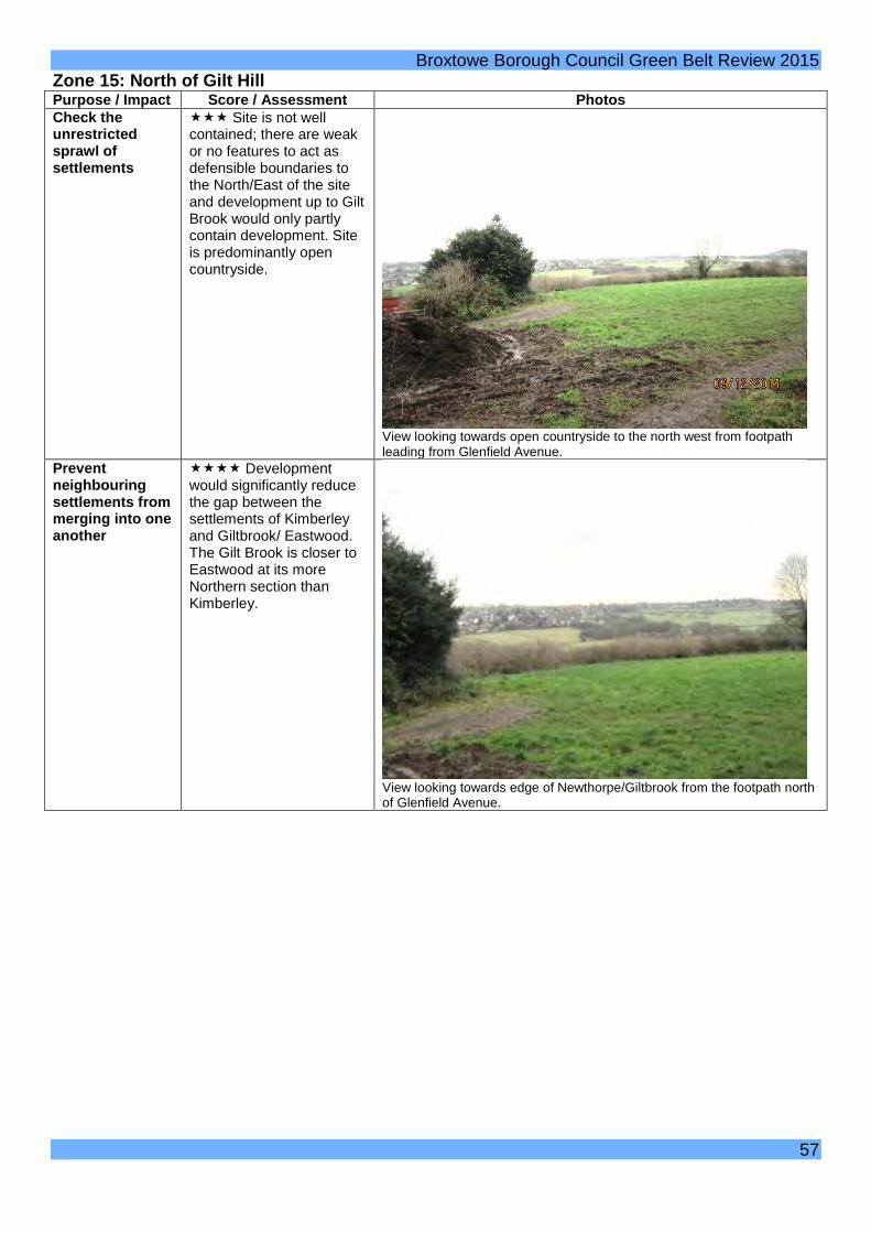
Broxtowe Borough Council Green Belt Review 2015 Zone 15: North of Gilt Hill Purpose / Impact Score / Assessment Photos Check the unrestricted sprawl of settlements
Site is not well contained; there are weak or no features to act as defensible boundaries to the North/East of the site and development up to Gilt Brook would only partly contain development. Site is predominantly open countryside.
View looking towards open countryside to the north west from footpath leading from Glenfield Avenue.
Prevent neighbouring settlements from merging into one another
Development would significantly reduce the gap between the settlements of Kimberley and Giltbrook/ Eastwood. The Gilt Brook is closer to Eastwood at its more Northern section than Kimberley.
View looking towards edge of Newthorpe/Giltbrook from the footpath north of Glenfield Avenue.
57

Broxtowe Borough Council Green Belt Review 2015 Assist in safeguarding the countryside from encroachment
Predominantly agricultural use, some inappropriate development in particular the school.
View looking along the public footpath from Glenfield Avenue in a northerly direction showing open fields.
Preserve the setting and special character of historic settlements
No heritage assets.
View looking along the public footpath from Glenfield Avenue towards houses to the east.
Assist in urban regeneration
It is considered that all sites in the Green Belt assist in urban regeneration. This is not considered to be a matter of difference between Green Belt sites and therefore this Green Belt purpose is not scored as part of the Framework.
58

Broxtowe Borough Council Green Belt Review 2015 Zone 16: North of High Spania Purpose / Impact Score / Assessment Photos Check the unrestricted sprawl of settlements
Site has two or more boundaries with Kimberley but has weak or no features to act as defensible boundaries to the north west.
View towards the rear of houses on Rolleston Crescent from footpath to the west of Trough Road.
Prevent neighbouring settlements from merging into one another
Development would result in some moderate reduction in the gap between Kimberley and Eastwood.
View looking west from the top of Cliff Boulevard.
Assist in safeguarding the countryside from encroachment
No inappropriate development other than telegraph pole no longer in use – site is predominantly agriculture.
View north of Oxbury road showing only inappropriate development. Former
59

Broxtowe Borough Council Green Belt Review 2015 telegraph pole, no longer in use.
Preserve the setting and special character of historic settlements
No heritage assets.
View looking west from the footpath North of Cliff Boulevard.
Assist in urban regeneration
It is considered that all sites in the Green Belt assist in urban regeneration. This is not considered to be a matter of difference between Green Belt sites and therefore this Green Belt purpose is not scored as part of the Framework.
60
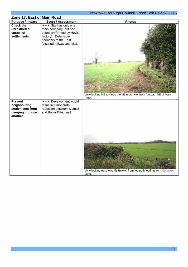
Broxtowe Borough Council Green Belt Review 2015 Zone 17: East of Main Road Purpose / Impact Score / Assessment Photos Check the unrestricted sprawl of settlements
Site has only one main boundary (but one boundary formed by Hovis factory). Defensible boundary to the East (disused railway and M1).
View looking NE towards the M1 motorway from footpath NE of Main Road.
Prevent neighbouring settlements from merging into one another
Development would result in a moderate reduction between Watnall and Bulwell/Hucknall.
View looking east towards Bulwell from footpath leading from Common Lane.
61

Broxtowe Borough Council Green Belt Review 2015 Assist in safeguarding the countryside from encroachment
Some inappropriate development but small in scale. Some residential and Industrial areas inset from the Green Belt are clearly visible and provide an urbanising feel.
Residential gardens on Main Road encroaching onto the Green Belt.
Preserve the setting and special character of historic settlements
No heritage assets.
View looking north from footpath leading from Main Road.
Assist in urban regeneration
It is considered that all sites in the Green Belt assist in urban regeneration. This is not considered to be a matter of difference between Green Belt sites and therefore this Green Belt purpose is not scored as part of the Framework.
62

Broxtowe Borough Council Green Belt Review 2015 Zone 18: Vicinity of Temple Lake Purpose / Impact Score / Assessment Photos Check the unrestricted sprawl of settlements
Site has two or more existing boundaries and could round off a settlement. Site is well constrained and A610 and M1 could form a potential defensible boundary. Site is not visually disconnected.
View from the A610 looking North
Prevent neighbouring settlements from merging into one another
Development would result in a reduction in the gap between settlements.
Assist in safeguarding the countryside from encroachment
A moderate amount of sporadic housing within the site.
View looking south from The Paddocks showing the boundary of a residential property.
Preserve the setting and special character of historic settlements
Site is within Nuthall Conservation Area and there are a number of listed buildings so could potentially have a significant impact.
Assist in urban regeneration
It is considered that all sites in the Green Belt assist in urban regeneration. This is not considered to be a matter of difference between Green Belt sites and therefore this Green Belt purpose is not scored as part of the Framework.
63

Broxtowe Borough Council Green Belt Review 2015 Zone 19: East of Park Avenue/ Knowle Lane Purpose / Impact Score / Assessment Photos Check the unrestricted sprawl of settlements
Site has only one adjoining boundary with settlement. Long limb into countryside but A610 and M1 could form a potential defensible boundary. Site is not completely visually disconnected.
View from the foothpath south of Knowle Park looking towards the A610.
Prevent neighbouring settlements from merging into one another
Development would result in a reduction in the gap between Kimberley and Nuthall (in Greater Nottingham).
View towards Nuthall beyond the A610 from the foothpath south of Knowle Park.
Assist in safeguarding the countryside from encroachment
No evidence of inappropriate development (agricultural use).
View to the south from footpath adjacent Knowlepark Farm.
64

Broxtowe Borough Council Green Belt Review 2015 Preserve the setting and special character of historic settlements
Potential impact on Nuthall Conservation Area and some listed buildings in particular around Home Farm. These impacts are mitigated to some extent by the severing effect of the busy A610.
Assist in urban regeneration
It is considered that all sites in the Green Belt assist in urban regeneration. This is not considered to be a matter of difference between Green Belt sites and therefore this Green Belt purpose is not scored as part of the Framework.
65
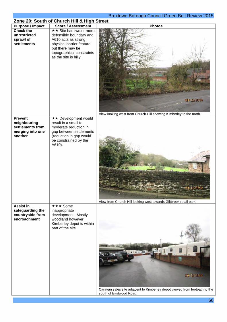
Broxtowe Borough Council Green Belt Review 2015 Zone 20: South of Church Hill & High Street Purpose / Impact Score / Assessment Photos Check the unrestricted sprawl of settlements
Site has two or more defensible boundary and A610 acts as strong physical barrier feature but there may be topographical constraints as the site is hilly.
View looking west from Church Hill showing Kimberley to the north.
Prevent neighbouring settlements from merging into one another
Development would result in a small to moderate reduction in gap between settlements (reduction in gap would be constrained by the A610).
View from Church Hill looking west towards Giltbrook retail park.
Assist in safeguarding the countryside from encroachment
Some inappropriate development. Mostly woodland however Kimberley depot is within part of the site.
Caravan sales site adjacent to Kimberley depot viewed from footpath to the south of Eastwood Road.
66

Broxtowe Borough Council Green Belt Review 2015 Preserve the setting and special character of historic settlements
Potentially development could cause a small impact on Conservation Area to the north east.
Assist in urban regeneration
It is considered that all sites in the Green Belt assist in urban regeneration. This is not considered to be a matter of difference between Green Belt sites and therefore this Green Belt purpose is not scored as part of the Framework.
67

Broxtowe Borough Council Green Belt Review 2015 Zone 21: West of Swingate Purpose / Impact Score / Assessment Photos Check the unrestricted sprawl of settlements
Site as a whole has two adjoining boundaries but is not well contained to the south and there are limited features to act as a defensible boundary.
View west from the footpath to the west of North Street.
Prevent neighbouring settlements from merging into one another
Development would result in significant reduction in the gap between Kimberley and Awsworth resulting in near total merging.
View looking north towards Kimberley from Spring Hill.
Assist in safeguarding the countryside from encroachment
Some minor inappropriate development (e.g. water tower and telegraph poles)
View looking west along Spring Hill showing inappropriate telegraph poles.
68

Broxtowe Borough Council Green Belt Review 2015 Preserve the setting and special character of historic settlements
No designated heritage assets.
View from footpath off North Street looking to the west.
Assist in urban regeneration
It is considered that all sites in the Green Belt assist in urban regeneration. This is not considered to be a matter of difference between Green Belt sites and therefore this Green Belt purpose is not scored as part of the Framework.
69

Main Built Up Area

44
27
22
28
24
42
26
23
25
30
41
3736
45
38
31
3940
29
34
32
35
33
43
Settlement Zone Overview
© Crown Copyright and database right 2015. Ordnance Survey 100019453You are not permitted to copy, sub-license, distribute or sell any of this data to third parties in any formNot To Scale
MapMBA Map 1
MBA Map 2
MBA Map 3
MBA Map 4
MBA Map 5
MBA Map 6
MBA Map 7
MBA Map 8
MBA
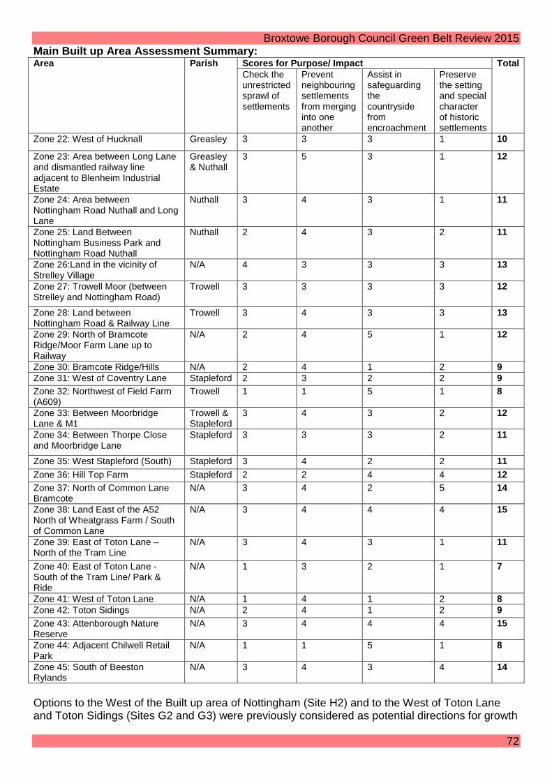
Broxtowe Borough Council Green Belt Review 2015 Main Built up Area Assessment Summary: Area Parish Scores for Purpose/ Impact Total
Check the unrestricted sprawl of settlements
Prevent neighbouring settlements from merging into one another
Assist in safeguarding the countryside from encroachment
Preserve the setting and special character of historic settlements
Zone 22: West of Hucknall Greasley 3 3 3 1 10
Zone 23: Area between Long Lane and dismantled railway line adjacent to Blenheim Industrial Estate
Greasley & Nuthall
3 5 3 1 12
Zone 24: Area between Nottingham Road Nuthall and Long Lane
Nuthall 3 4 3 1 11
Zone 25: Land Between Nottingham Business Park and Nottingham Road Nuthall
Nuthall 2 4 3 2 11
Zone 26:Land in the vicinity of Strelley Village
N/A 4 3 3 3 13
Zone 27: Trowell Moor (between Strelley and Nottingham Road)
Trowell 3 3 3 3 12
Zone 28: Land between Nottingham Road & Railway Line
Trowell 3 4 3 3 13
Zone 29: North of Bramcote Ridge/Moor Farm Lane up to Railway
N/A 2 4 5 1 12
Zone 30: Bramcote Ridge/Hills N/A 2 4 1 2 9 Zone 31: West of Coventry Lane Stapleford 2 3 2 2 9 Zone 32: Northwest of Field Farm (A609)
Trowell 1 1 5 1 8
Zone 33: Between Moorbridge Lane & M1
Trowell & Stapleford
3 4 3 2 12
Zone 34: Between Thorpe Close and Moorbridge Lane
Stapleford 3 3 3 2 11
Zone 35: West Stapleford (South) Stapleford 3 4 2 2 11 Zone 36: Hill Top Farm Stapleford 2 2 4 4 12 Zone 37: North of Common Lane Bramcote
N/A 3 4 2 5 14
Zone 38: Land East of the A52 North of Wheatgrass Farm / South of Common Lane
N/A 3 4 4 4 15
Zone 39: East of Toton Lane – North of the Tram Line
N/A 3 4 3 1 11
Zone 40: East of Toton Lane - South of the Tram Line/ Park & Ride
N/A 1 3 2 1 7
Zone 41: West of Toton Lane N/A 1 4 1 2 8 Zone 42: Toton Sidings N/A 2 4 1 2 9 Zone 43: Attenborough Nature Reserve
N/A 3 4 4 4 15
Zone 44: Adjacent Chilwell Retail Park
N/A 1 1 5 1 8
Zone 45: South of Beeston Rylands
N/A 3 4 3 4 14
Options to the West of the Built up area of Nottingham (Site H2) and to the West of Toton Lane and Toton Sidings (Sites G2 and G3) were previously considered as potential directions for growth
72

Broxtowe Borough Council Green Belt Review 2015 in the Tribal report. The findings of this review partly endorse this view as described in more detail below. 1.Toton Strategic Location for Growth The Core Strategy established the principle of development in this strategic Location with Policy 2 listing a Strategic Location for Growth on land East and West of Toton Lane including Toton Sidings in the vicinity of the proposed HS2 station. This includes land assessed as sites G2 and G3 in Tribal. The purpose to the Green Belt Review is to consider the issue of where the appropriate boundaries should be set. It is considered (as the Core Strategy Inspector did) that land in the central portion of the site (Zone 41) bounded by the A52 to the North Toton/ Stapleford Lane to the East, the built form of Toton to the South and Toton Sidings to the west would meet the NPPF test of amounting to defensible Green Belt boundaries. The commentary below indicates where other long term boundaries may be. Boundary of the Strategic Location West of Toton/ Stapleford Lane There are a number of options for a western boundary. One is the River Erewash which is on the Borough Boundary. However the preferred western boundary is the proposed HS2 line. It is acknowledged that the final decision over HS2 has not yet been taken. However in the event of a decision at Toton being confirmed the line itself will have a severing effect and will make further development to the West very difficult given this severing effect and will form a very strong defensible long term boundary. This boundary will include the potential for development associated with HS2 and large scale employment development close to the station, part of which could be on the major developed site identified at Toton Sidings (Zone 42) in the 2004 Broxtowe Local Plan, and will also allow for the principles established by the HS2 Toton Advisory Committee at their meeting of 15 December to be adhered to. This can include the additional green infrastructure corridor running North to South and also the strategic Green Infrastructure corridor along the River Erewash to the West could be enhanced. Extensive options will be available to provide additional amenity space, natural greenspace, parks and outdoor sports facilities within this site. It will also allow for the setting of Sandiacre Lock Conservation Area to be preserved with development set away from it and on the opposite side of HS2 rail line. Boundary of the Strategic Location East of Toton/ Stapleford Lane The recommended boundary to the East is the tram line and park and ride (Zone 40) which is a strong long term defensible boundary. This will still allow for the Core Strategy development requirements to be met together with significant employment development if this is the route that the HS2/ Toton Advisory Committee conclude on. In the unlikely event of either the HS2 Station not being at Toton, or even more unlikely HS2 themselves requiring substantial portions of land directly in association with the station to the extent that Broxtowe ambitions for the site will require further land, then this can be considered before the final version of the Plan is published. Toton Conclusion These boundaries will allow for a north/ south wildlife corridor to be included adjacent to Toton Sidings, land for a school extension if one is required, a minimum of 16 hectares of Green Infrastructure which can include green buffers adjacent to all existing residential areas, the 500 minimum homes and significantly more employment land than the 18,000 square metres minimum specified in the Core Strategy. The precise location and mix of this and any other development remains a matter for the HS2 Toton Advisory Committee, who had a draft masterplan presented to them at their meeting on 15th December, which they will be able to consider further in the early part of 2015.
73

Broxtowe Borough Council Green Belt Review 2015 2. Land north of Stapleford and west of Bramcote
The Core Strategy removed the Field Farm site from the Green Belt when it was adopted on 17 September 2014. The finding of this review confirms that land to the north of Field Farm contains a strong defensible boundary in the railway line, and other potential sites do not to the same extent. Also, taking the Green Belt Review as a whole other sites around the main built up area are more important to retain in the Green Belt, in particular the various sites to the west of Greater Nottingham which have a far more severe impact on reducing the critically important strategic Green Belt gap between the built up areas of Nottingham and Derby and the towns and villages in between. If residential allocations take place in this area then the following points are relevant. North West of Field Farm (Zone 32) This site is considered to be unavailable for residential development. The Pit Lane open space is proposed to remain as such with enhanced playing pitch provision potentially north of the brook. The land to the north of the brook is to be transferred to Trowell Parish Council. East of Field Farm and West of Coventry Lane (Zone 31) Land East of Field Farm and West of Coventry Lane is considered a potential development option for a residential allocation. Care would need to be taken in terms of the layout of any development in that Stapleford Hill is immediately to the south west of this site given the potential shading effect of this large hill on new residential properties. This could have an adverse impact on their amenity and lead to very few opportunities to benefit from passive solar gain. Stapleford Hill itself is unsuitable for any development and would remain undeveloped with recreational opportunities in this site to be enhanced. East of Coventy Lane and North of Bramcote Ridge (Zone 29) This site is considered unsuitable for residential development. This is within an area that provides an extensive and prominent strategic Green Infrastructure corridor (Map 3.3 and Policy 16 of the ACS) linking Broxtowe with the city of Nottingham to the east. The disused golf course between Balmoral Drive and Deddington Lane abuts this site and is a protected open area and prominent area for special protection. This former golf course site has a parkland character which is more closely related to the character of land to the west of the site (Moor Lane and the Bramcote Schools site) than the land to the east which has a plantation character. In order to retain this important parkland character for the area as a whole (the Green Belt site and adjacent protected local plan site) it is important to restrict any built development in this site to land south of the ridge. The most northerly of the Bramcote Schools buildings is a prominent and intrusive feature in this location. It may be possible to enhance this site with the demolition of this building if a school redevelopment does take place (see below). South of Bramcote Ridge (Zone 30) This site is considered partly suitable for residential and other development. The Bramcote Schools site and Leisure Centre is defined in the 2004 Local Plan as a major developed site in the Green Belt. Information from the school is that they are seeking funding to modernise and rationalise their accommodation to significantly improve the education provision for their students, and residential development on part of the land may be necessary to release funding. If so there are options available within this area which would have a minimal impact on the purposes of
74

Broxtowe Borough Council Green Belt Review 2015 including land in the Green Belt. Broxtowe are in the process of reviewing Leisure provision and the outcome of this is not yet confirmed in so far as it would affect decisions over Bramcote Leisure centre, which is a large prominent building fronting the A52. Bramcote Hills Park and Bramcote Hill are unsuitable for any development. Stapleford/ Bramcote Conclusion There are two sites within this location that may be suitable for residential allocations. One is the land bounded by the existing allocation at Field Farm to the west, the railway line to the north, Coventry Lane and the crematorium to the east and Stapleford Hill to the south (Zone 31). The other is land at the south east of the location within Zone 30 to the south of Bramcote ridge comprising part of the land identified as a major developed site in the 2004 Broxtowe Local Plan, and potentially some additional land at the far south east of this site fronting directly onto A52, subject to adequate replacement playing pitch provision being provided elsewhere in this location.
75

Consultation Green Belt Boundary Change
© Crown Copyright and database right 2015.Ordnance Survey 100019453
Not to scale
MBA Bramcote and Stapleford
You are not permitted to copy, sub-license, distribute or sell any of this data to third parties in any form.
¯
SITE MAP BOROUGH MAP
LegendConsultation area
Local Plan 2004environmentalconstraint
Major developedsite in green belt
Green Belt
11.9 of 125.9 ha (approx.9%) of consultation area
would be required for housingbased on existing information
in the SHLAA

Consultation Green Belt Boundary Change
© Crown Copyright and database right 2015.Ordnance Survey 100019453
Not to scale
MBA Toton
You are not permitted to copy, sub-license, distribute or sell any of this data to third parties in any form.
¯
SITE MAP BOROUGH MAP
LegendConsultation area
Local Plan 2004environmentalconstraint
Major developedsite in green belt
Green Belt
16.67 of 119.33 ha (approx.14%) of consultation area
would be required for housingbased on existing information
in the SHLAA

22
23
© Crown Copyright and database right 2015. Ordnance Survey 100019453 You are not permitted to copy, sub-license, distribute or sell any of this data to third parties in any form.Not To Scale
¯ MBA Map 1Green Belt Review
Settlement Zones Map04 February 2015
Borough Boundary
Green Belt
Zones
Defined Zone Boundary

Broxtowe Borough Council Green Belt Review 2015 Zone 22: West of Hucknall Purpose / Impact Score / Assessment Photos Check the unrestricted sprawl of settlements
The site is partially contained with Hucknall to the east, Long Lane to the South and the M1 motorway to the West. The site is open countryside with no obvious defensible boundary to the north.
View from north of Long Lane looking back towards the east.
Prevent neighbouring settlements from merging into one another
Development would reduce the gap to a moderate extent between the west of Hucknall and north of Kimberley with some reduction in the gap between Hucknall and Eastwood. The M1 has an influence on the perceived reduction of this gap.
View towards the western edge of Hucknall.
Assist in safeguarding the countryside from encroachment
The site contains power lines, mobile phone masts, sporadic housing development and Watnall Brickworks. However the site retains a rural open character despite the inappropriate development within it.
View looking north towards Long Lane showing mobile phone mast.
79

Broxtowe Borough Council Green Belt Review 2015 Preserve the setting and special character of historic settlements
No heritage assets.
Assist in urban regeneration
It is considered that all sites in the Green Belt assist in urban regeneration. This is not considered to be a matter of difference between Green Belt sites and therefore this Green Belt purpose is not scored as part of the Framework.
80

Broxtowe Borough Council Green Belt Review 2015 Zone 23: Area between Long Lane and dismantled Railway line adjacent to Blenheim Industrial estate Purpose / Impact
Score / Assessment Photos
Check the unrestricted sprawl of settlements
The site is reasonably well contained with Long Lane to the North, the Rolls Royce allocated site; in Ashfield together with Bulwell Wood and the Blenheim Industrial estate in Nottingham to the east, the M1 to the west and partly contained by a dismantled railway line to the south. However there would be no rounding off and the site is adjacent to and between Hucknall and Nottingham
Looking East with Long Lane to the right (south) of the picture.
Prevent neighbouring settlements from merging into one another
The site would result in the complete merging of Hucknall (Rolls Royce allocated site in Ashfield) and Nottingham.
View from near the motorway towards Bulwell Wood with Blenheim Industrial Estate to the south and the Rolls Royce site further north (out of picture)
81

Broxtowe Borough Council Green Belt Review 2015 Assist in safeguarding the countryside from encroachment
The site contains the western edge of the Rolls Royce site, an electricity substation and farm buildings which collectively have caused some moderate encroachment. The site is generally open countryside
View north looking at the western edge of the hardstanding on the Rolls Royce site, the majority of which is in Ashfield.
Preserve the setting and special character of historic settlements
No heritage assets.
Assist in urban regeneration
It is considered that all sites in the Green Belt assist in urban regeneration. This is not considered to be a matter of difference between Green Belt sites and therefore this Green Belt purpose is not scored as part of the Framework.
82

24
25
© Crown Copyright and database right 2015. Ordnance Survey 100019453 You are not permitted to copy, sub-license, distribute or sell any of this data to third parties in any form.Not To Scale
¯ MBA Map 2Green Belt Review
Settlement Zones Map04 February 2015
Borough Boundary
Green Belt
Zones
Defined Zone Boundary

Broxtowe Borough Council Green Belt Review 2015 Zone 24: Area between Nottingham Road Nuthall and Long Lane Purpose / Impact
Score / Assessment Photos
Check the unrestricted sprawl of settlements
The site is partially contained with the main built up area to the east, Nottingham Road to the South and the M1 motorway to the West. The dismantled railway and Blenheim Industrial Estate also forms a partial boundary to the site to the North. The site is open countryside.
View looking south towards Nottingham Road.
Prevent neighbouring settlements from merging into one another
Development towards the south of the site would result in the near total merging of the built up areas of Nottingham to the east and Kimberley to the west. If development were contained to the majority of the site further north then this total merging would be avoided albeit there would still be a significant reduction in the gap between the main built up areas of Nottingham and Kimberley.
View south of the M1 footbridge looking SE towards Greater Nottingham.
Assist in safeguarding the countryside from encroachment
The site contains power lines, mobile phone masts, a ribbon of housing development on Nottingham Road, high fencing around a wooded area, industrial areas in Bulwell, however the site retains a rural open character despite the inappropriate development within and adjacent to it.
View east over M1 motorway showing industrial areas in Greater Nottingham.
84

Broxtowe Borough Council Green Belt Review 2015 Preserve the setting and special character of historic settlements
No heritage assets.
Assist in urban regeneration
It is considered that all sites in the Green Belt assist in urban regeneration. This is not considered to be a matter of difference between Green Belt sites and therefore this Green Belt purpose is not scored as part of the Framework.
85

Broxtowe Borough Council Green Belt Review 2015 Zone 25: Land between Nottingham Business Park and Nottingham Road Nuthall Purpose / Impact
Score / Assessment Photos
Check the unrestricted sprawl of settlements
The site is well contained with the main built up area to the east, Nottingham Business Park to the South (albeit that there remains a Green Belt gap to the North of the business park in the Nottingham City Council area) and the M1 motorway to the West. Nottingham Road Nuthall also forms a boundary to the site to the North and a further defensible boundary within this site is the A610 from Junction 26 of the M1 motorway to Nuthall island. The site is open countryside.
View from Woodhouse Way looking south towards Nottingham Business Park.
Prevent neighbouring settlements from merging into one another
Development towards the North of the site would result in the near total merging of the built up areas of Nottingham to the east and Kimberley to the west. If development were contained to the southern part of the site, south of the A610, then this total merging would be avoided albeit there would still be a significant reduction in the gap between the main built up areas of Nottingham and Kimberley.
View from Nottingham Road looking south towards junction 26 of the M1 which is screened by the higher land.
Assist in safeguarding the countryside from encroachment
Development at the north of the site includes residential properties, the Methodist church, the Parish Council Offices and associated hard surfaced parking areas and the main A610 trunk road bisects this site. If development were contained to the southern part of the site, south of the A610, then there are no existing features of inappropriate development in this site.
86

Broxtowe Borough Council Green Belt Review 2015 View looking south towards residential properties on Nottingham Road.
Preserve the setting and special character of historic settlements
The Nuthall Conservation Area is immediately to the west of the site abutting the M1 motorway with substantial numbers of listed buildings close to the motorway. Given the severing effect of the M1 motorway, development in this site would have a limited impact on the setting of the conservation area and listed buildings.
Assist in urban regeneration
It is considered that all sites in the Green Belt assist in urban regeneration. This is not considered to be a matter of difference between Green Belt sites and therefore this Green Belt purpose is not scored as part of the Framework.
87

27
28
26
© Crown Copyright and database right 2015. Ordnance Survey 100019453 You are not permitted to copy, sub-license, distribute or sell any of this data to third parties in any form.Not To Scale
¯ MBA Map 3Green Belt Review
Settlement Zones Map04 February 2015
Borough Boundary
Green Belt
Zones
Defined Zone Boundary

Broxtowe Borough Council Green Belt Review 2015 Zone 26: Land in Vicinity of Strelley Village Purpose / Impact
Score / Assessment Photos
Check the unrestricted sprawl of settlements
Only one, partial, boundary with adjacent settlement (the ‘main built up area’). Not well contained and would not round off a settlement. Motorway could form a defensible boundary; no other obvious options for defensible boundaries. Undulating land so does not extend over topographical features.
View looking Northeast over the M1 Motorway.
Prevent neighbouring settlements from merging into one another
A large area of land is involved, which would have a moderate effect on the large gap between the main built up area and Ilkeston. Notwithstanding the significant conservation issues, there is some potential for rounding off the village of Strelley given its dispersed nature and its location immediately adjacent to the administrative boundary of the City of Nottingham.
View looking from Main Street Strelley towards the M1.
Assist in safeguarding the countryside from encroachment
The village itself it wholly located within the Green Belt, including dwellings, some storage use, telephone and electricity lines, equestrian uses. Otherwise predominantly agricultural.
View looking North towards Strelley Village.
89
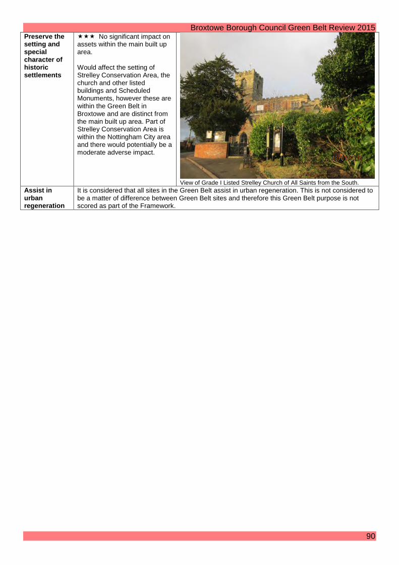
Broxtowe Borough Council Green Belt Review 2015 Preserve the setting and special character of historic settlements
No significant impact on assets within the main built up area. Would affect the setting of Strelley Conservation Area, the church and other listed buildings and Scheduled Monuments, however these are within the Green Belt in Broxtowe and are distinct from the main built up area. Part of Strelley Conservation Area is within the Nottingham City area and there would potentially be a moderate adverse impact.
View of Grade I Listed Strelley Church of All Saints from the South.
Assist in urban regeneration
It is considered that all sites in the Green Belt assist in urban regeneration. This is not considered to be a matter of difference between Green Belt sites and therefore this Green Belt purpose is not scored as part of the Framework.
90

Broxtowe Borough Council Green Belt Review 2015 Zone 27: Trowell Moor (between Strelley and Nottingham Road) Purpose / Impact
Score / Assessment Photos
Check the unrestricted sprawl of settlements
Single boundary with adjacent main built up area. Not well contained and would not round off a settlement. Motorway could form a defensible boundary to the west; however this would involve releasing a very large site. Alternatively, higher land part way between the A6002 and the motorway might form the basis of a defensible boundary. A609 would form a defensible boundary to the south. (If the motorway were used as a boundary, the released site would extend over the topographical feature of this higher land.)
View Southeast towards Nottingham. Prevent neighbouring settlements from merging into one another
A large area of land is involved, which, if the higher land were used as a boundary, would have a moderate effect on the large gap between the main built up area and Ilkeston/Trowell. (If the motorway were used as a boundary, the ‘score’ would be .)
View Southeast towards Nottingham.
Assist in safeguarding the countryside from encroachment
The site has some inappropriate development including the motorway services, a man-made reservoir, caravan storage, several dwellings and commercial uses along the A6002 and A609 around the periphery of the site, and some equestrian uses. Otherwise predominantly agricultural.
View of man-made reservoir from the South.
Preserve the A limited amount of inter-visibility with Wollaton Hall, adjacent to the main built up area.
91

Broxtowe Borough Council Green Belt Review 2015 setting and special character of historic settlements
Would affect the setting of Strelley Conservation Area, the church and other listed buildings and Scheduled Monuments, however these are within the Green Belt in Broxtowe and are distinct from the main built up area. Part of Strelley Conservation Area is within the Nottingham City area and there would potentially be a moderate adverse impact.
Assist in urban regeneration
It is considered that all sites in the Green Belt assist in urban regeneration. This is not considered to be a matter of difference between Green Belt sites and therefore this Green Belt purpose is not scored as part of the Framework.
92

Broxtowe Borough Council Green Belt Review 2015 Zone 28: Land between Nottingham Road & Railway Line Purpose / Impact
Score / Assessment Photos
Check the unrestricted sprawl of settlements
One boundary with adjacent settlement (the main built up area) to the east and another partial boundary to the south. Well contained but would not round off a settlement. A609 could form a defensible boundary to the north and the motorway to the west. Alternatively, higher land to the east of the motorway might form the basis of a defensible boundary. (If the motorway were used as a boundary, the released site would extend over the topographical feature of this higher land.)
View of signs on Nottingham Road looking Southeast.
Prevent neighbouring settlements from merging into one another
Development would result in a very large reduction in the gap between the main built up area and Trowell.
Assist in safeguarding the countryside from encroachment
The site has some inappropriate development including the Balloon Woods industrial estate, a nursery and several dwellings and commercial uses along the A609 around the periphery of the site, the latter in particular giving something of an ‘urban fringe’ character. Otherwise predominantly agricultural.
View of Balloon Woods Industrial Estate from the North.
93

Broxtowe Borough Council Green Belt Review 2015 Preserve the setting and special character of historic settlements
Inter-visibility with Stapleford Hill and Bramcote Hill, adjacent to the main built up area. Otherwise, no significant impact on assets within the main built up area. (Would affect the settings of the listed Trowell Hall and Swancar Bridge, and the non-listed asset of the canal; however these are within the Green Belt and are distinct from the main built up area.)
View of Bramcote and Stapleford Hills from the North.
Assist in urban regeneration
It is considered that all sites in the Green Belt assist in urban regeneration. This is not considered to be a matter of difference between Green Belt sites and therefore this Green Belt purpose is not scored as part of the Framework.
94

30
31
29
32
© Crown Copyright and database right 2015. Ordnance Survey 100019453 You are not permitted to copy, sub-license, distribute or sell any of this data to third parties in any form.Not To Scale
¯ MBA Map 4Green Belt Review
Settlement Zones Map04 February 2015
Borough Boundary
Green Belt
Zones
Defined Zone Boundary

Broxtowe Borough Council Green Belt Review 2015 Zone 29: North of Bramcote Ridge/Moor Farm Lane up to Railway
Purpose / Impact Score / Assessment Photos Check the unrestricted sprawl of settlements
The site has two boundaries adjoining a settlement; three if Zone 30 were removed from the Green Belt. It could be said to ‘round off’ a settlement. The site is well contained by strong physical features which can act as defensible boundaries.
View from Coventry Lane looking SE across the railway.
Prevent neighbouring settlements from merging into one another
Development would result in a more than moderate reduction in the size of a gap between Bramcote and Stapleford.
View from Moor Farm Lane looking North.
Assist in safeguarding the countryside from encroachment
The site does not have any inappropriate developments and therefore no encroachment
Land immediately north of Moor Farm Lane.
96

Broxtowe Borough Council Green Belt Review 2015
Preserve the setting and special character of historic settlements
The site will have no adverse impact on conservation areas or heritage assets associated with settlements.
Assist in urban regeneration
It is considered that all sites in the Green Belt assist in urban regeneration. This is not considered to be a matter of difference between Green Belt sites and therefore this Green Belt purpose is not scored as part of the Framework.
97

Broxtowe Borough Council Green Belt Review 2015 Zone 30: Bramcote Ridge/Hills
Purpose / Impact
Score / Assessment Photos
Check the unrestricted sprawl of settlements
The site has two full boundaries and one partial boundary adjoining a settlement. The site is well contained by strong physical features which can act as defensible boundaries but the site extends over topographical features. The Green Belt extends over Bramcote Ridge. A52/Coventry Lane act as strong defensible boundaries. The railway or Moor Farm Inn Lane could be used as the Northern boundary.
View from Bramcote Hill looking north. Prevent neighbouring settlements from merging into one another
Development would result in a significant reduction in the gap between Bramcote and Stapleford.
View of Bramcote Hills park from the car park looking east.
98

Broxtowe Borough Council Green Belt Review 2015 Assist in safeguarding the countryside from encroachment
The site includes a large amount of existing inappropriate developments which have caused a significant degree of encroachment. The site contains a number of large buildings including the school, the leisure centre and Brethen Hall.
View from Bramcote Hill looking east
View from Burnt Hill looking North towards Bramcote showing the leisure centre to the middle left and the school building on the ridge just beyond this on the right.
Preserve the setting and special character of historic settlements
The site could have a less than moderate adverse impact on heritage assets associated with settlements i.e. there could be an impact on the Hemlock Stone unlisted heritage asset.
View of the Hemlock Stone from Coventry Lane looking west
99

Broxtowe Borough Council Green Belt Review 2015
Assist in urban regeneration
It is considered that all sites in the Green Belt assist in urban regeneration. This is not considered to be a matter of difference between Green Belt sites and therefore this Green Belt purpose is not scored as part of the Framework.
100

Broxtowe Borough Council Green Belt Review 2015 Zone 31: West of Coventry Lane Purpose / Impact Score / Assessment Photos Check the unrestricted sprawl of settlements
The site has two boundaries with a settlement (taking into account the recent Green Belt amendment at Field Farm). Coventry Lane could be used as a defensible boundary. The site is currently visually disconnected from any settlement, albeit it is connected to the Field Farm allocation. Site is well contained with the allocation of Field Farm to the West, the railway line forming a defensible boundary to the North, Stapleford Hill to the Southwest, and A6002 to the East.
View from Stapleford Hill looking towards the McCann depot to the North East.
Prevent neighbouring settlements from merging into one another
Development would result in a moderate reduction in the size of the gap between Bramcote and Stapleford.
View from Sidings Lane looking west.
Assist in safeguarding the countryside from encroachment
The site includes some existing inappropriate developments which have caused some encroachment e.g. the Crematorium and the industrial units.
View from Sidings Lane looking north.
101

Broxtowe Borough Council Green Belt Review 2015 Preserve the setting and special character of historic settlements
The site could have a less than moderate adverse impact on heritage assets associated with settlements i.e. there could be an impact on the Hemlock Stone unlisted heritage asset.
View of Hemlock stone viewed from Coventry Lane looking west.
Assist in urban regeneration
It is considered that all sites in the Green Belt assist in urban regeneration. This is not considered to be a matter of difference between Green Belt sites and therefore this Green Belt purpose is not scored as part of the Framework.
102

Broxtowe Borough Council Green Belt Review 2015 Zone 32: North West of Field Farm (A609) Purpose / Impact
Score / Assessment Photos
Check the unrestricted sprawl of settlements
The site has three boundaries with a settlement (taking into account the recent Green Belt amendment at Field Farm). The site has strong defensible boundaries ( the existing settlement boundaries plus the railway to the north) and does not extend over topographical features.
Railway at the northern boundary.
Prevent neighbouring settlements from merging into one another
The land that would be removed does not constitute a strategic green belt gap between the settlements of Trowell and Stapleford.
View from Pit Lane looking SE.
Assist in safeguarding the countryside from encroachment
The site does not have any inappropriate developments, other than the car park serving the recreation ground, and therefore no encroachment.
View from the footpath North of Ilkeston Road looking SW along the line of the Boundary Brook.
103

Broxtowe Borough Council Green Belt Review 2015 Preserve the setting and special character of historic settlements
The site will have no adverse impact on conservation areas or heritage assets associated with settlements.
Assist in urban regeneration
It is considered that all sites in the Green Belt assist in urban regeneration. This is not considered to be a matter of difference between Green Belt sites and therefore this Green Belt purpose is not scored as part of the Framework.
104

34
35
33
© Crown Copyright and database right 2015. Ordnance Survey 100019453 You are not permitted to copy, sub-license, distribute or sell any of this data to third parties in any form.Not To Scale
¯ MBA Map 5Green Belt Review
Settlement Zones Map04 February 2015
Borough Boundary
Green Belt
Zones
Defined Zone Boundary

Broxtowe Borough Council Green Belt Review 2015 Zone 33: Between Moorbridge Lane and the M1 Purpose/ Impact Score / Assessment Photos Check the unrestricted sprawl of settlements
Effectively a single long eastern boundary with Stapleford. The River Erewash forms a defensible boundary to the west and the M1 motorway to the north. Development would not amount to a ‘rounding off’ of Stapleford.
Looking east from the footpath next to the River Erewash. The rear of properties on Moorbridge Lane are visible on the right of the picture and Stapleford and Bramcote Hills are visible to the rear of houses in North Stapleford.
Prevent neighbouring settlements from merging into one another
There would be significant reduction in the gap between Stapleford and Stanton Gate in Erewash Borough.
Looking East from the footpath next to the River Erewash. The edge of Stapleford Hill is visible in the far right.
106

Broxtowe Borough Council Green Belt Review 2015 Assist in safeguarding the countryside from encroachment
The site has some urbanising features including flood defences, residential properties on the north side of Moorbridge Lane, large sewer covers and water infrastructure next to the river. The M1 itself is very noticeable in this site and is a significant urbanising feature for much of the site.
Looking North to the M1 with River Erewash in the foreground.
Preserve the setting an special character of historic settlements
No significant impact on historic assets albeit some effect on the setting of the Erewash Canal.
Assist in urban regeneration
It is considered that all sites in the Green Belt assist in urban regeneration. This is not considered to be a matter of difference between Green Belt sites and therefore this Green Belt purpose is not scored as part of the Framework
107

Broxtowe Borough Council Green Belt Review 2015 Zone 34: Between Thorpe Close and Moorbridge Lane Purpose/ Impact Score / Assessment Photos Check the unrestricted sprawl of settlements
Effectively a single long eastern boundary with Stapleford. The River Erewash forms a defensible boundary. Development would not amount to a ‘rounding off’ of Stapleford.
Looking North from the footbridge at the end of Mill Road.
Prevent neighbouring settlements from merging into one another
There would be a moderate reduction in what is already a very narrow gap between Sandiacre and Stapleford in the south of the site and a more significant reduction to Stanton Gate in Erewash in the north of the site.
Looking North from the public footpath with rear of properties on Northwood Street out of picture to the right.
Assist in safeguarding the countryside from encroachment
The site has some urbanising features including flood defences, industrial buildings/ storage areas, and given the narrowness of the gap the nearby residential properties in Stapleford are visible in close proximity. However, even allowing for this, there is a more open feel to the site north of Mill Road.
Looking West from the public footpath at a point close to rear of properties on Northwood Street.
108

Broxtowe Borough Council Green Belt Review 2015 Preserve the setting an special character of historic settlements
There are some large mill buildings on the Erewash side, but no significant adverse impact on their setting, given the intervening railway line and River Erewash.
Looking North along the public footpath with the River Erewash to the left a short distance South of Moorbridge Lane.
Assist in urban regeneration
It is considered that all sites in the Green Belt assist in urban regeneration. This is not considered to be a matter of difference between Green Belt sites and therefore this Green Belt purpose is not scored as part of the Framework
109

Broxtowe Borough Council Green Belt Review 2015 Zone 35: West Stapleford (south) Purpose/ Impact Score / Assessment Photos Check the unrestricted sprawl of settlements
Effectively a single long eastern boundary with Stapleford. The railway line which is in Broxtowe in the south of the site and the River Erewash form defensible boundaries. Development would not amount to a ‘rounding off’ of Stapleford.
Looking Northeast towards Sandiacre Road in Stapleford from the railway bridge.
Prevent neighbouring settlements from merging into one another
At the southern end development would comprise a near total merging of Stapleford with Sandiacre. North of the point at which the railway crosses the River Erewash, the merging would be significant but not complete, with a gap on the Sandiacre side of the river.
Looking Southeast back towards Stapleford.
Assist in safeguarding the countryside from encroachment
The site is urban fringe in character with high chain link fencing adjacent to the footpath and further high palisade type fencing towards the south of the site. There is a large bridge over the railway, an electricity substation and a number of equestrian buildings and equipment.
Electricity substation from public footpath close to the end of Sandiacre Road.
110

Broxtowe Borough Council Green Belt Review 2015 Preserve the setting an special character of historic settlements
There are some large mill buildings on the Erewash side, but no significant adverse impact on their setting, given the intervening railway line and River Erewash.
Assist in urban regeneration
It is considered that all sites in the Green Belt assist in urban regeneration. This is not considered to be a matter of difference between Green Belt sites and therefore this Green Belt purpose is not scored as part of the Framework
111

41
38
37
36
39
40
© Crown Copyright and database right 2015. Ordnance Survey 100019453 You are not permitted to copy, sub-license, distribute or sell any of this data to third parties in any form.Not To Scale
¯ MBA Map 6Green Belt Review
Settlement Zones Map04 February 2015
Borough Boundary
Green Belt
Zones
Defined Zone Boundary

Broxtowe Borough Council Green Belt Review 2015 Zone 36: Hill Top Farm Purpose / Impact
Score / Assessment Photos
Check the unrestricted sprawl of settlements
The site as a whole has 3 boundaries which adjoin the settlement of Stapleford. The site would ‘round off’ Stapleford to a certain extent although development along the ridge would be very prominent. The site is contained by residential development of the existing urban area of Stapleford on three sides (North, West & South) and to the East it is wholly contained by the A52. The site extends over (and wholly includes) a ridge which is designated as a prominent area for special protection in saved polices (E13) of the Core Strategy (carried forward from the 2004 Local Plan). The ridge runs through the centre of the site and is visible from surrounding settlements including Chilwell.
View from greenway crossing point (nearest to the A52) looking West towards the cemetery.
Prevent neighbouring settlements from merging into one another
Development of the site would reduce the gap between Stapleford and Chilwell.
View from elevated central part of site looking towards Chilwell – the buildings visible are those at Teesdale Court.
113

Broxtowe Borough Council Green Belt Review 2015 Assist in safeguarding the countryside from encroachment
The site has a small amount of inappropriate development in the form of telecoms equipment to the West and a road/track running through the site to the East. The Western part of the site is a cemetery; however this is considered to be appropriate development in the Green Belt. The remainder of the site is undeveloped agricultural land and small areas of woodland (the largest of which is located adjacent to Baulk Lane) and has the feel of ‘open countryside’.
View towards Hall Farm showing telecoms equipment in woodland.
Preserve the setting and special character of historic settlements
The North of the site abuts the Nottingham Road Conservation Area. The Conservation Area appraisal recognises the importance of the character and setting of the area whereby it states that “over and between the buildings, there are attractive views south, over heavily wooded long garden plots, to the tall and striking rocky outcrop in the middle distance. This greenery and undeveloped high ground has probably changed little since the historic buildings were constructed, and maintains the historic semi-rural setting of the listed buildings”. It is particularly important to note numerous Listed Buildings on the Southern part of Nottingham Road (adjacent to the Northern edge of the site) which form an important part of the historic character of the settlement. Listed Buildings include; St Johns Primary School (Grade II Listed), Frameshop (Grade II Listed) and numerous ‘knitters cottages’ along Nottingham Road. The knitters Cottages in particular are significant because of their top floor knitters’ workshop windows the views from which could be impacted upon should the site be developed, especially when considering the land level differences.
Assist in urban regeneration
It is considered that all sites in the Green Belt assist in urban regeneration. This is not considered to be a matter of difference between Green Belt sites and therefore this Green Belt purpose is not scored as part of the Framework.
114

Broxtowe Borough Council Green Belt Review 2015 Zone 37: North of Common Lane Bramcote Purpose/ Impact Score / Assessment Photos Check the unrestricted sprawl of settlements
The site is triangular in shape and has two boundaries adjoining the existing urban areas of Bramcote and Stapleford. To the Northwest and the Northeast the site is well contained by the strong defensible boundaries of the A52 and Town Street / Chilwell Lane. However to the South the site is less well contained by Common Lane and to some extent the track which forms the Greenway. The site does extend over a topographical feature and almost entirely consists of Burnt Hill, a prominent area to the North of Bramcote.
View from North of Site looking towards Stapleford Hill, A52 separates the fields from the existing urban area of Stapleford.
Prevent neighbouring settlements from merging into one another
Development would result in a more than moderate reduction in the gap between Bramcote / Stapleford and Chilwell.
View from North of site looking West towards Stapleford, Stapleford Hill can be seen in the middle distance on the right of the photo.
115
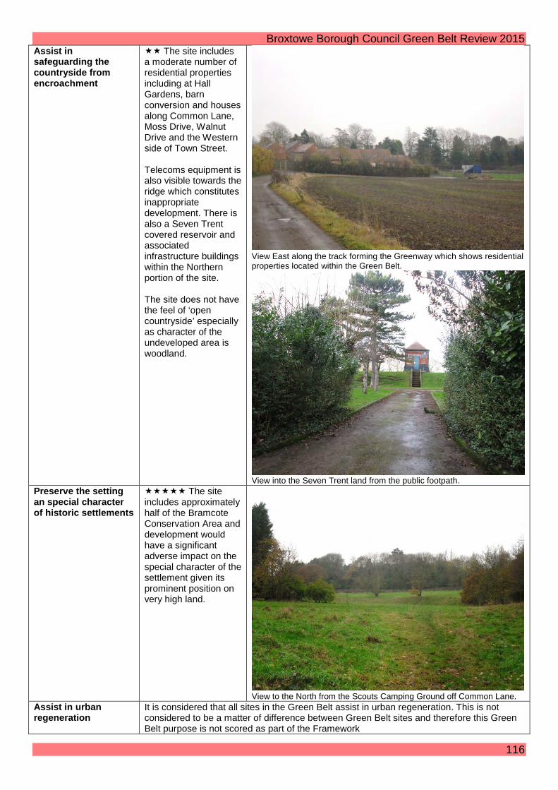
Broxtowe Borough Council Green Belt Review 2015 Assist in safeguarding the countryside from encroachment
The site includes a moderate number of residential properties including at Hall Gardens, barn conversion and houses along Common Lane, Moss Drive, Walnut Drive and the Western side of Town Street. Telecoms equipment is also visible towards the ridge which constitutes inappropriate development. There is also a Seven Trent covered reservoir and associated infrastructure buildings within the Northern portion of the site. The site does not have the feel of ‘open countryside’ especially as character of the undeveloped area is woodland.
View East along the track forming the Greenway which shows residential properties located within the Green Belt.
View into the Seven Trent land from the public footpath.
Preserve the setting an special character of historic settlements
The site includes approximately half of the Bramcote Conservation Area and development would have a significant adverse impact on the special character of the settlement given its prominent position on very high land.
View to the North from the Scouts Camping Ground off Common Lane.
Assist in urban regeneration
It is considered that all sites in the Green Belt assist in urban regeneration. This is not considered to be a matter of difference between Green Belt sites and therefore this Green Belt purpose is not scored as part of the Framework
116

Broxtowe Borough Council Green Belt Review 2015 Zone 38: Land East of the A52 North of Wheatgrass Farm/ South of Common Lane Purpose / Impact
Score / Assessment Photos
Check the unrestricted sprawl of settlements
The site has two boundaries adjoining the settlements of Bramcote & Chilwell. The site does not round off a settlement. The site is well contained to the East and in a large part to the South by the existing urban area. The North is less well contained by Common Lane and to some extent the track which forms the Greenway. The West and part of the South is only contained by the track which forms the Greenway. Whilst the topography of the site is sloping towards the North it does not extend over a ridge.
View from greenway South East towards Chilwell
Prevent neighbouring settlements from merging into one another
Development would result in a significant reduction in the gap between Stapleford, Bramcote and Chilwell albeit that these areas are already partially joined.
Assist in safeguarding the countryside from encroachment
The site includes Wheatgrass Farm but notwithstanding this has no other encroachment and so does have the feel of ‘open countryside’ albeit that it is in a very urban setting (e.g. with traffic noise from the A52 and the hard edge of existing housing in Chilwell and Bramcote).
View from Common Lane South East towards hard edge of recent development at Orton Fields Bramcote.
Preserve the setting and special character of historic settlements
The East and part of the North of the site is adjacent to the Bramcote Conservation Area and development would have a more then moderate adverse impact on this aspect of the historic settlement.
Assist in urban regeneration
It is considered that all sites in the Green Belt assist in urban regeneration. This is not considered to be a matter of difference between Green Belt sites and therefore this Green Belt purpose is not scored as part of the Framework.
117
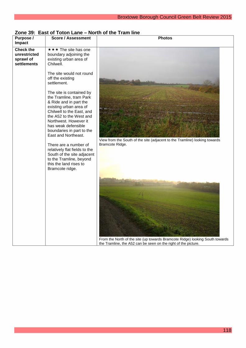
Broxtowe Borough Council Green Belt Review 2015
Zone 39: East of Toton Lane – North of the Tram line Purpose / Impact
Score / Assessment Photos
Check the unrestricted sprawl of settlements
The site has one boundary adjoining the existing urban area of Chilwell. The site would not round off the existing settlement. The site is contained by the Tramline, tram Park & Ride and in part the existing urban area of Chilwell to the East, and the A52 to the West and Northwest. However it has weak defensible boundaries in part to the East and Northeast. There are a number of relatively flat fields to the South of the site adjacent to the Tramline, beyond this the land rises to Bramcote ridge.
View from the South of the site (adjacent to the Tramline) looking towards Bramcote Ridge.
From the North of the site (up towards Bramcote Ridge) looking South towards the Tramline, the A52 can be seen on the right of the picture.
118

Broxtowe Borough Council Green Belt Review 2015 Prevent neighbouring settlements from merging into one another
Development of the site would significantly reduce the physical gap between Chilwell and Stapleford leading to more than moderate merging. The topography the site means that it is highly visible from the surrounding settlements and therefore the perception of the narrowing of the gap between settlements would be significant.
View from South of the Tramline looking Northwest showing Stapleford (centre distance) and the prominence of the site adjacent to it.
Assist in safeguarding the countryside from encroachment
The site is typified by more encroachment to the South than the North. The South of the site includes the Garden Centre, Japanese Water Gardens & associated development (including Café) off the Bardills Roundabout all located within the Green Belt. The Northern Part of the site includes very little development and does have the feel of ‘open countryside’ albeit that it is in a very urban setting (e.g. with traffic noise from the A52 and houses visible in the distance on most sides).
View from Greenway looking North demonstrating the ‘open countryside’ feel of the site.
Preserve the setting and special character of historic settlements
The site would have no adverse impact on the setting and special character of a historic settlement as there are no Listed buildings or Conservation Areas within the vicinity of the site.
Assist in urban regeneration
It is considered that all sites in the Green Belt assist in urban regeneration. This is not considered to be a matter of difference between Green Belt sites and therefore this Green Belt purpose is not scored as part of the Framework.
119

Broxtowe Borough Council Green Belt Review 2015 Zone 40: East of Toton Lane – South of the Tram Line/ Park & Ride Purpose / Impact
Score / Assessment Photos
Check the unrestricted sprawl of settlements
The site has two boundaries adjoining Chilwell. It is well contained by strong physical features, to the East and the South the site is contained by the existing urban area and to the West the site is contained by Toton/Stapleford Lane. The Tramline acts as a defensible boundary to the North. The site does not extend over topographical features.
View along the tramline to the East towards Chilwell – showing that the tramline is a defensible boundary
View from the South of the tramline looking North East – again demonstrating that the tramline is a defensible boundary in the landscape
Prevent neighbouring settlements from merging into one another
Development of the site would result in a moderate reduction of the physical gap between Chilwell and Stapleford. Development would also further link Toton and Chilwell, albeit that these areas are already physically joined.
120

Broxtowe Borough Council Green Belt Review 2015 View from Hill Top Farm Stapleford towards Chilwell (showing fields included in part of this site in the middle distance).
Assist in safeguarding the countryside from encroachment
The site includes a moderate amount of encroachment and does not have the feel of ‘open countryside’. Development includes the Tram Park & Ride, the tram line itself and associated tram related equipment (e.g. overhead electricity lines, pylons, attenuation pond etc.). There is also a stretch of large electricity pylons spanning from the sub-station on Toton/Stapleford Lane across the site towards Chilwell.
View across the attenuation pond to the North of the tramline looking towards the park and ride.
View from tramline crossing point (where the Greenway meets the tramline) up towards the park and ride site.
Preserve the setting and special character of historic settlements
The site would have no adverse impact on the setting and special character of a historic settlement as there are no Listed buildings or Conservation Areas within the vicinity of the site.
Assist in urban regeneration
It is considered that all sites in the Green Belt assist in urban regeneration. This is not considered to be a matter of difference between Green Belt sites and therefore this Green Belt purpose is not scored as part of the Framework.
121

Broxtowe Borough Council Green Belt Review 2015 Zone 41: West of Toton Lane Purpose / Impact
Score / Assessment Photos
Check the unrestricted sprawl of settlements
Site is bounded by a settlement on one side (Toton). The site is extremely well contained with the existing residential area of Toton to the South, the railway sidings to the West, Toton/Stapleford Lane to the East and the A52 to the North. The site, whilst undulating, does not extend over topographical features. The Core Strategy Inspector (in her report to the Councils issued 24 July 2014) stated that “development of land at Toton…would not undermine the fundamental Green Belt objective of separating Derby from Nottingham as the railway sidings, with or without the HS2 station, provide a strong barrier to the west. The merging of Toton and Stapleford would be mitigated by the presence of the A52 and by careful design of new development including the siting of green space”.
View from footpath at Southwest of site looking Northeast towards Stapleford, trees on left of picture are those surrounding Bessell Lane Farm.
View looking North down the public footpath (centre of photo) showing Toton Sidings to the left of the picture and houses in Stapleford to the right.
122

Broxtowe Borough Council Green Belt Review 2015 Prevent neighbouring settlements from merging into one another
Development of the whole site would result in virtually complete merging of settlements albeit that the physical connectivity between settlements (Toton and Stapleford) is extremely limited by the intervening dual carriageway (A52) which along this stretch has no pedestrian crossing points other than through the school which is restricted access. Notwithstanding this, the topography of the site means that the perception of the reduced gap to existing housing in Stapleford would be limited as much of the site is not visible from the existing dwellings in Stapleford and screening of the A52 also mitigates this.
View North at most visible point towards housing in Stapleford – tree line denotes the screening for the A52.
Assist in safeguarding the countryside from encroachment
The site includes a large amount of existing inappropriate development including; various electricity pylons, an electricity substation, telecoms infrastructure (including 30 m tower), a school (and associated development such as sports pitches, floodlights and wire & palisade fencing), a sewage works (albeit that it is well screened), a vacant dwelling and derelict building associated with a plant nursery (including Greenhouses) and Bessell Lane Farm.
View from footpath looking Northeast toward the Nursery and Substation on Stapleford/Toton Lane both of which are screened by trees.
123

Broxtowe Borough Council Green Belt Review 2015
View from footpath adjacent to the school North/Northeast across the school playing pitches to the school itself.
Preserve the setting and special character of historic settlements
The site would have a less than moderate adverse impact on the setting of the historical character of Sandiacre (in Erewash). Whilst development may have some impact on the historical character of Sandiacre (including the Mill/Industrial buildings in Sandiacre and Sandiacre Lock) the area, as existing, is urban/ industrial in character. Erewash Borough Council did not object to the inclusion of this site as a Strategic Location for Growth in the Core Strategy. The site would have no adverse impact on the setting and special character of a historic settlements within Broxtowe Borough as there are no additional Listed buildings or Conservation Areas within the vicinity of the site.
Assist in urban regeneration
It is considered that all sites in the Green Belt assist in urban regeneration. This is not considered to be a matter of difference between Green Belt sites and therefore this Green Belt purpose is not scored as part of the Framework.
124

42
43
© Crown Copyright and database right 2015. Ordnance Survey 100019453 You are not permitted to copy, sub-license, distribute or sell any of this data to third parties in any form.Not To Scale
¯ MBA Map 7Green Belt Review
Settlement Zones Map04 February 2015
Borough Boundary
Green Belt
Zones
Defined Zone Boundary

Broxtowe Borough Council Green Belt Review 2015 Zone 42: Toton Sidings Purpose / Impact
Score / Assessment Photos
Check the unrestricted sprawl of settlements
The south east part of the site is contained by an existing built-up area and is visually connected with this site. The sidings themselves are at a lower level and as the ground rises to the East, towards the North of the location the less visually connected the site would be with the existing built up area of Broxtowe. Notwithstanding this as growth occurs in the North of the site then the site would become visually connected with the built up areas of Broxtowe. In addition the Western part of the site when viewed from the East is to some extent visually connected with the existing built up area of Erewash on the other side of the sidings as there are very few undeveloped ‘open’ vistas between Erewash and Broxtowe. A tree belt (of largely young silver birch) on the eastern side of the railway sidings (continued through the railway sidings into the built up area of Erewash) and the sidings themselves gives the perception of a visual gap between the built up area of Broxtowe and Erewash. The location is contained by physical features that act as defensible boundaries. The whole of the West side of the location is physically contained by the River Erewash, the Sidings themselves could act as a defensible boundary within the location itself as it isn’t possible to cross from one side of the sidings to the other within this site. The North is contained by the A52. The east side is contained by
View to the South showing the sharp drop in land levels down to the sidings themselves. The proposed HS2 station is located approximately where the industrial building is located to the top right of the photo.
View to the Southwest overlooking the tree belt and the railway sidings showing high level floodlights.
126

Broxtowe Borough Council Green Belt Review 2015 either existing residential development or forms part of the Strategic Location for Growth whereby the principle of removing the site from the Green Belt is already set. The South West Area could be contained by the smaller watercourse on the Broxtowe side. Development in this location would round off development (existing and proposed) further East.
Prevent neighbouring settlements from merging into one another
Housing in Erewash relatively close and clearly visible, although railway line & sidings mean that to the West of the site there is not pedestrian connectivity which would keep the settlements separate to some extent. The tree belt within & adjacent to the sidings also helps to form some level of distinction between settlements albeit that there would be virtually no visual break. The recreational site to the Southeast forms a very narrow gap between the settlements Toton and Long Eaton.
View South from footpath adjacent to housing in Toton showing proximity of housing in Long Eaton (albeit that the River Erewash is intervening).
Assist in safeguarding the countryside from encroachment
The site includes a large amount of existing inappropriate development including; the railway sidings themselves (and associated development such as high level floodlights, storage buildings, access roads etc.), Greenwood Community Centre (and associated development including hard standing, security camera and pole), car scrapping and high & low electricity pylons. Whilst recreational uses are appropriate in the Green Belt (such as the Portland Road Park) the maintenance of ‘natural’ sites as formal open space does mean that the
View North towards the scrap yard on Bessell Lane
127
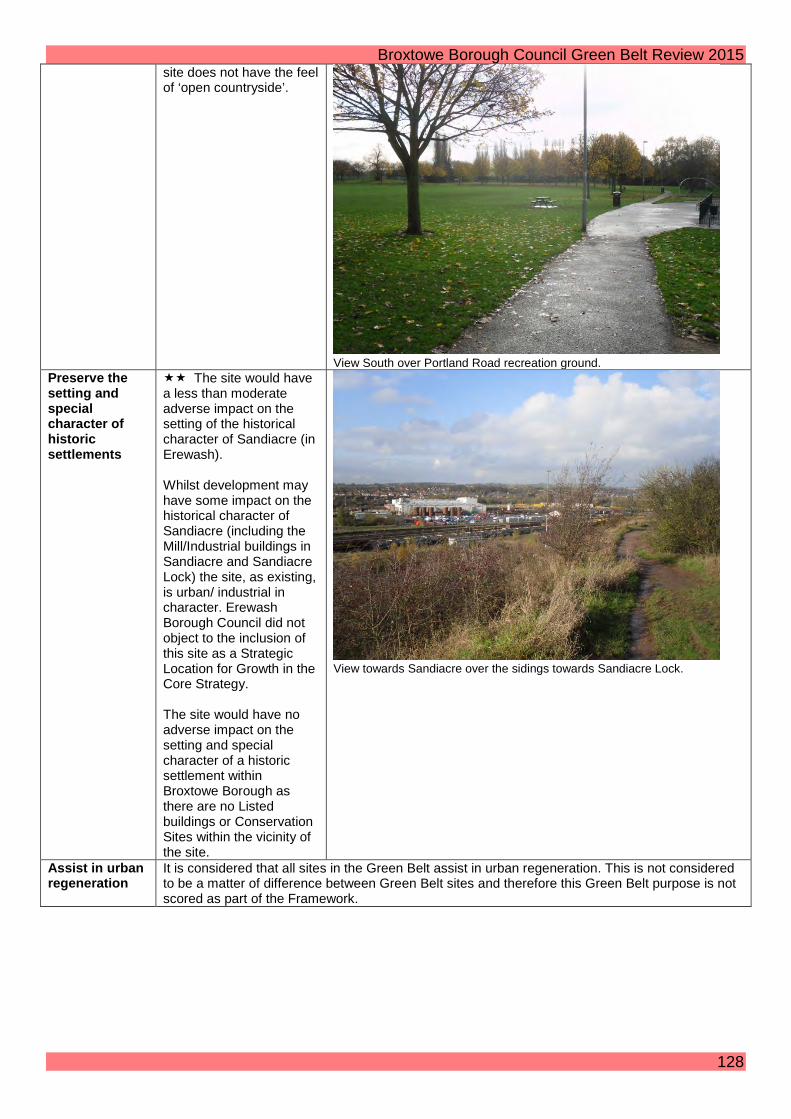
Broxtowe Borough Council Green Belt Review 2015 site does not have the feel of ‘open countryside’.
View South over Portland Road recreation ground.
Preserve the setting and special character of historic settlements
The site would have a less than moderate adverse impact on the setting of the historical character of Sandiacre (in Erewash). Whilst development may have some impact on the historical character of Sandiacre (including the Mill/Industrial buildings in Sandiacre and Sandiacre Lock) the site, as existing, is urban/ industrial in character. Erewash Borough Council did not object to the inclusion of this site as a Strategic Location for Growth in the Core Strategy. The site would have no adverse impact on the setting and special character of a historic settlement within Broxtowe Borough as there are no Listed buildings or Conservation Sites within the vicinity of the site.
View towards Sandiacre over the sidings towards Sandiacre Lock.
Assist in urban regeneration
It is considered that all sites in the Green Belt assist in urban regeneration. This is not considered to be a matter of difference between Green Belt sites and therefore this Green Belt purpose is not scored as part of the Framework.
128

Broxtowe Borough Council Green Belt Review 2015 Zone 43: Adjacent Chilwell Retail Park Purpose / Impact
Score / Assessment Photos
Check the unrestricted sprawl of settlements
The site is very well contained and has three boundaries adjoining the settlement of Chilwell (North, East & West). The Southern boundary is the River Erewash which also acts as a strong defensible boundary. Development in this site would round off the settlement of Chilwell and does not extend over topographical features.
View from Nottingham Road looking West across the site showing the rear of the units on Chilwell Retail Park.
Prevent neighbouring settlements from merging into one another
Development would have a very limited impact on the reduction of the gap between Chilwell and Long Eaton.
View from Nottingham Road looking Southeast.
129
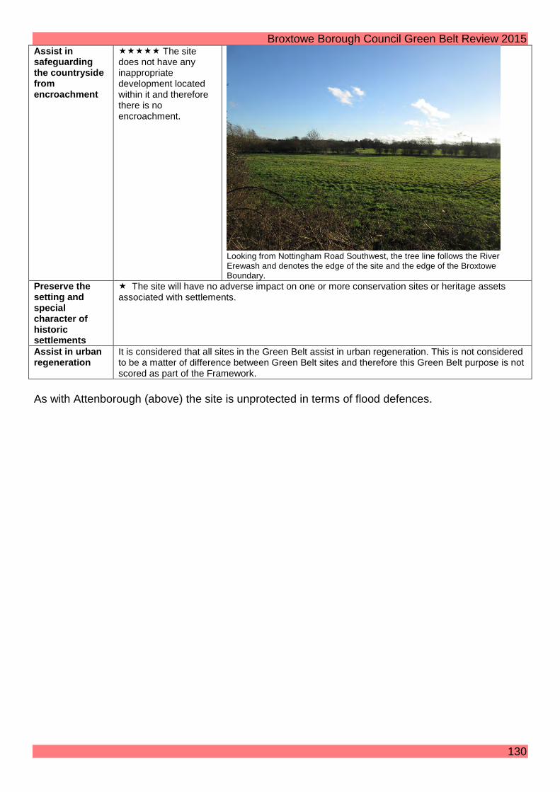
Broxtowe Borough Council Green Belt Review 2015 Assist in safeguarding the countryside from encroachment
The site does not have any inappropriate development located within it and therefore there is no encroachment.
Looking from Nottingham Road Southwest, the tree line follows the River Erewash and denotes the edge of the site and the edge of the Broxtowe Boundary.
Preserve the setting and special character of historic settlements
The site will have no adverse impact on one or more conservation sites or heritage assets associated with settlements.
Assist in urban regeneration
It is considered that all sites in the Green Belt assist in urban regeneration. This is not considered to be a matter of difference between Green Belt sites and therefore this Green Belt purpose is not scored as part of the Framework.
As with Attenborough (above) the site is unprotected in terms of flood defences.
130

44
45
© Crown Copyright and database right 2015. Ordnance Survey 100019453 You are not permitted to copy, sub-license, distribute or sell any of this data to third parties in any form.Not To Scale
¯ MBA Map 8Green Belt Review
Settlement Zones Map04 February 2015
Borough Boundary
Green Belt
Zones
Defined Zone Boundary

Broxtowe Borough Council Green Belt Review 2015 Zone 44: Attenborough Nature Reserve Purpose/ Impact Score / Assessment Photos Check the unrestricted sprawl of settlements
Although the north west and north east boundaries are adjoining the settlements of Attenborough and Beeston Rylands and the River Trent forms a defensible boundary, there would be no sense of rounding off an existing settlement.
Looking Northeast with properties on Meadow Lane beyond the floodwall and railway line.
Prevent neighbouring settlements from merging into one another
Development would significantly reduce the gap between Clifton in the City of Nottingham and Barton-in-Fabis in Rushcliffe.
Looking Northeast from the centre of the Nature Reserve.
Assist in safeguarding the countryside from encroachment
The site is almost entirely given over to wetlands. Although there are some parking sites, a nature centre, flood defences and a number of quite large bridges, the site has a tranquil rural character.
The Nature Centre from the Northeast.
132

Broxtowe Borough Council Green Belt Review 2015 Preserve the setting an special character of historic settlements
There would be more than moderate adverse impact on the setting of Attenborough Conservation Site and the Listed St Mary’s Church which immediately abut the site.
St Mary’s Church from the Southwest.
Assist in urban regeneration
It is considered that all sites in the Green Belt assist in urban regeneration. This is not considered to be a matter of difference between Green Belt sites and therefore this Green Belt purpose is not scored as part of the Framework
Since the entire site is wetland and not defended by the Left Bank Flood Alleviation Scheme which opened in 2012, it would not be practically possible to develop here even if the whole site could be drained and nature conservation issues were disregarded.
133

Broxtowe Borough Council Green Belt Review 2015 Zone 45: South of Beeston Rylands Purpose / Impact Score / Assessment Photos Check the unrestricted sprawl of settlements
Although the north west boundary adjoins the settlement of Beeston Rylands and the River Trent forms a defensible boundary there would be only a minimal sense of rounding off an existing settlement given that the site is separated from Beeston Rylands by the canal
Looking Northeast from footpath next to the Canal.
Prevent neighbouring settlements from merging into one another
Development would significantly reduce the gap between Beeston Rylands and Clifton in the City of Nottingham.
Looking Northeast to the footpath next to the canal.
Assist in safeguarding the countryside from encroachment
The site is almost entirely given over to open recreational land, although there are large electricity pylons, Flood defences and some parking sites.
Looking Southeast towards Clifton.
134

Broxtowe Borough Council Green Belt Review 2015 Preserve the setting and special character of historic settlements
There would be more than moderate adverse impact on the setting of Clifton Hall and the Conservation Area in Clifton village on the Nottingham side of the River Trent.
There would also be an impact on the Listed Buildings within the Boots site, however this would be to a lesser extent given the existing industrial setting of the buildings.
View North along the Canal.
Assist in urban regeneration
It is considered that all sites in the Green Belt assist in urban regeneration. This is not considered to be a matter of difference between Green Belt sites and therefore this Green Belt purpose is not scored as part of the Framework.
135

Trowell

46
49
47
48© Crown Copyright and database right 2015. Ordnance Survey 100019453 You are not permitted to copy, sub-license, distribute or sell any of this data to third parties in any form.Not To Scale
¯ TrowellGreen Belt Review
Settlement Zones Map04 February 2015
Borough Boundary
Green Belt
Zones
Defined Zone Boundary

Broxtowe Borough Council Green Belt Review 2015 Trowell Assessment Summary: Site Parish Scores for Purpose/ Impact Total
Check the unrestricted sprawl of settlements
Prevent neighbouring settlements from merging into one another
Assist in safeguarding the countryside from encroachment
Preserve the setting and special character of historic settlements
Zone 46: North of Trowell Trowell 4 2 3 2 11 Zone 47: East of Trowell Trowell 1 2 3 2 8 Zone 48: South West Trowell Trowell 3 3 3 2 11 Zone 49: West of Trowell Trowell 3 4 2 2 11 The Core Strategy defined key settlements for growth of which Trowell village is not one. This Green Belt Assessment does not re-visit that principle. However, as Trowell is already inset from the Green Belt it is necessary to consult on the review of the Green Belt boundary around the village.
138

Broxtowe Borough Council Green Belt Review 2015 Zone 46: North of Trowell Purpose/ Impact Score / Assessment Photos Check the unrestricted sprawl of settlements
The Canal to the west and Cossall Road to the east could form defensible boundaries. However there is no defensible boundary to the north. The site has one clear boundary with Trowell plus ribbon development across Cossall Road. There would be no rounding off of Trowell in functional terms. The site does not extend across topographical features however the land slopes down to the west. Development of the small site to the NW would not constitute sprawl because it is already developed.
View looking SE from Stoney Lane.
Prevent neighbouring settlements from merging into one another
There would be a small reduction in the large gap between Trowell Village and the City of Nottingham.
View from Cossall Road looking SW.
139
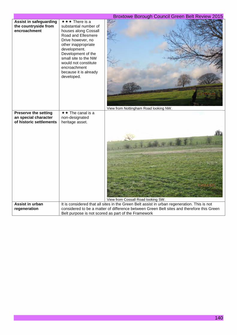
Broxtowe Borough Council Green Belt Review 2015 Assist in safeguarding the countryside from encroachment
There is a substantial number of houses along Cossall Road and Ellesmere Drive however, no other inappropriate development. Development of the small site to the NW would not constitute encroachment because it is already developed.
View from Nottingham Road looking NW.
Preserve the setting an special character of historic settlements
The canal is a non-designated heritage asset.
View from Cossall Road looking SW.
Assist in urban regeneration
It is considered that all sites in the Green Belt assist in urban regeneration. This is not considered to be a matter of difference between Green Belt sites and therefore this Green Belt purpose is not scored as part of the Framework
140

Broxtowe Borough Council Green Belt Review 2015 Zone 47: East of Trowell Purpose / Impact
Score / Assessment Photos
Check the unrestricted sprawl of settlements
The site has one boundary with Trowell plus ribbon development along the A609. The site has strong defensible boundaries (the M1 as one boundary and either the canal or the A609 as the other) and may extend over topographical features depending on which boundary was chosen.
View from the A609 looking along the canal footpath eastwards.
Prevent neighbouring settlements from merging into one another
Development of the Northern part of the site would lead to a very limited reduction in the gap between Trowell and the main built up area. Development of the South of the site would lead to a moderate reduction in the gap albeit that the Motorway has a severing impact meaning the perception of the reduction would be less than moderate.
View from the A6007 looking north east towards the M1.
Assist in safeguarding the countryside from encroachment
The site has some inappropriate development including the school and some housing.
View of dwelling along canal footpath.
141

Broxtowe Borough Council Green Belt Review 2015 Preserve the setting and special character of historic settlements
The site will have some impact on the setting of the Nottingham Canal which is a non-designated heritage asset associated with the village of Trowell.
View from A609 looking South.
Assist in urban regeneration
It is considered that all sites in the Green Belt assist in urban regeneration. This is not considered to be a matter of difference between Green Belt sites and therefore this Green Belt purpose is not scored as part of the Framework.
142
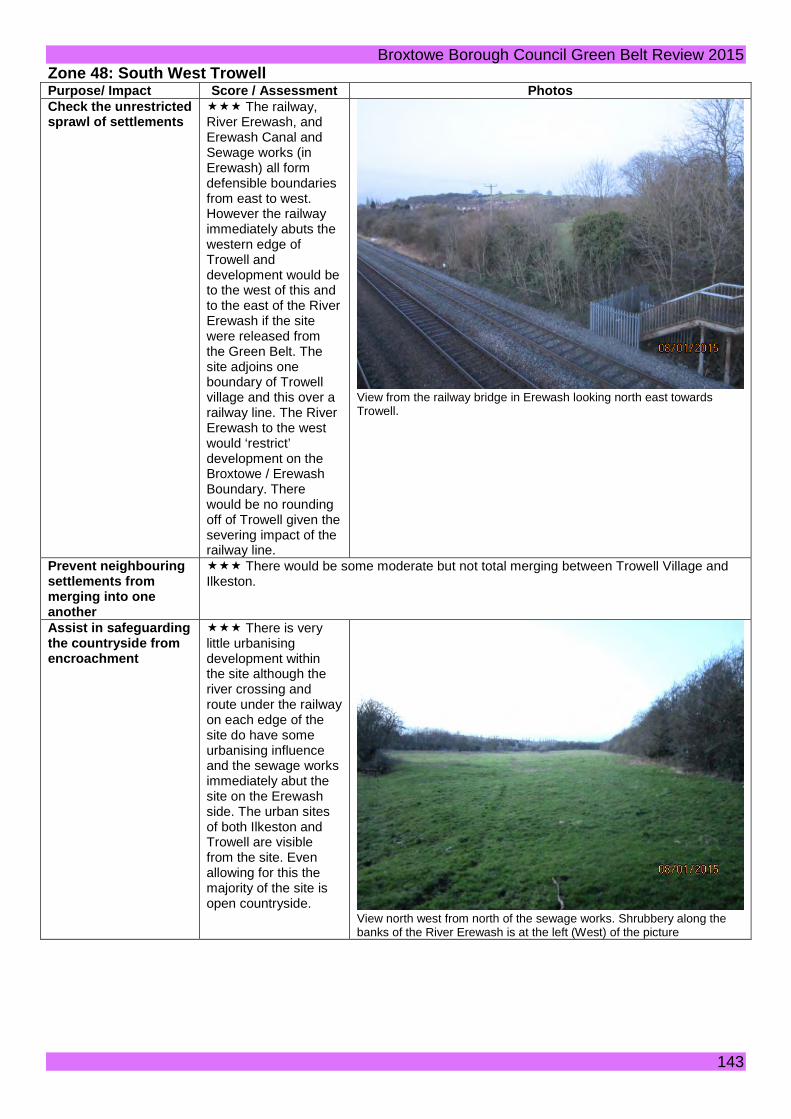
Broxtowe Borough Council Green Belt Review 2015 Zone 48: South West Trowell Purpose/ Impact Score / Assessment Photos Check the unrestricted sprawl of settlements
The railway, River Erewash, and Erewash Canal and Sewage works (in Erewash) all form defensible boundaries from east to west. However the railway immediately abuts the western edge of Trowell and development would be to the west of this and to the east of the River Erewash if the site were released from the Green Belt. The site adjoins one boundary of Trowell village and this over a railway line. The River Erewash to the west would ‘restrict’ development on the Broxtowe / Erewash Boundary. There would be no rounding off of Trowell given the severing impact of the railway line.
View from the railway bridge in Erewash looking north east towards Trowell.
Prevent neighbouring settlements from merging into one another
There would be some moderate but not total merging between Trowell Village and Ilkeston.
Assist in safeguarding the countryside from encroachment
There is very little urbanising development within the site although the river crossing and route under the railway on each edge of the site do have some urbanising influence and the sewage works immediately abut the site on the Erewash side. The urban sites of both Ilkeston and Trowell are visible from the site. Even allowing for this the majority of the site is open countryside.
View north west from north of the sewage works. Shrubbery along the banks of the River Erewash is at the left (West) of the picture
143

Broxtowe Borough Council Green Belt Review 2015 Preserve the setting an special character of historic settlements
The canal is a heritage asset on the Erewash side, albeit its setting in this industrial context with significant industrial development on the Ilkeston side would not be unduly affected.
View of St Helens Church from the West
Assist in urban regeneration
It is considered that all sites in the Green Belt assist in urban regeneration. This is not considered to be a matter of difference between Green Belt sites and therefore this Green Belt purpose is not scored as part of the Framework
144

Broxtowe Borough Council Green Belt Review 2015 Zone 49: West of Trowell Purpose/ Impact Score / Assessment Photos Check the unrestricted sprawl of settlements
The railway, River Erewash and Erewash Canal (in Erewash) all form defensible boundaries from east to west. However the railway immediately abuts the western edge of Trowell and development would be to the west of this and to the east of the River Erewash if the site were released from the Green Belt. At best the site adjoins one boundary of Trowell village and this over a railway line. The River Erewash to the west would ‘restrict’ development on the Broxtowe / Erewash Boundary. There would be no rounding off of Trowell given the severing impact of the railway line.
River Erewash looking south
Prevent neighbouring settlements from merging into one another
There would be some significant but not total merging between Trowell Village and Ilkeston.
View looking west towards Ilkeston
145

Broxtowe Borough Council Green Belt Review 2015 Assist in safeguarding the countryside from encroachment
The site is influenced by urban features such as residential properties, storage use and the urban sites of both Ilkeston and Trowell visible from the site. Even allowing for this the majority of the site is open countryside.
Open countryside between Trowell and Ilkeston
Preserve the setting an special character of historic settlements
The canal is a heritage asset on the Erewash side, albeit its setting in this industrial context with significant industrial development on the Ilkeston side would not be unduly affected.
Erewash Canal looking South
Assist in urban regeneration
It is considered that all sites in the Green Belt assist in urban regeneration. This is not considered to be a matter of difference between Green Belt sites and therefore this Green Belt purpose is not scored as part of the Framework
146

Broxtowe Borough Council Green Belt Review 2015
Appendix A: Toton Strategic Location for Growth Policy 2 of the Adopted Broxtowe Core Strategy identifies land east and west of Toton Lane including Toton Sidings in the vicinity of the proposed HS2 station in Broxtowe as a Strategic Location for growth. In various policies and text of the Core Strategy the following are identified as minimum requirements within the strategic location
• 500 homes • 18,000 square metres of employment development • 16 Hectares of green infrastructure • Not prejudicing the tram link to the HS2 Station • Not prejudicing the road access to the HS2 Station
Proposed new development within the Strategic Location for growth The map on page 149 shows the following amount and mix of uses. The proposed development figures given below are rounded to the nearest 0.5 Hectare.
West of Toton/ Stapleford Lane • 24.5 Hectares mixed use employment/ commercial development on the site of the station
and to the north and east. • 9 Hectares publicly accessible open space through the south and centre of the site • 6.5 Hectares low density residential development between the areas of green space
towards to south of the site to link with existing public rights of way to the south • 10 Hectares high density residential development to the north of this • 2.5 Hectares local centre to the east of the site opposite the tram park and ride site.
Additional Land included with the location but not proposed to be developed (other than to allow road access to the station)
• 17.5 Hectares buffer at the north of the site comprising school land, open space and the existing Sewage treatment site
• 2 Hectares west of Toton/ Stapleford Land comprising mainly of the electricity sub station
East of Toton/ Stapleford Lane (south of the tram line) • 2 Hectares mixed use employment/ leisure development to the south and east of the park
and ride. • 8 Hectares publicly accessible open space through the south centre and west of the site
linking with the green space to the west via improved connections across the road and to existing public rights of way to the north.
• 6 Hectares low density housing to the east of the site and south of the tram line
Additional land included within the location but not proposed to be developed (other than with an extension to the tram)
• 4.8 hectare tram park and ride site
147

Broxtowe Borough Council Green Belt Review 2015
In addition the resolution of the Broxtowe HS2/ Toton Advisory Committee at their meeting on 15th December 2014 was that
• A north-south wildlife corridor be included in the consultation. • Existing rights of way be included on the plans for consultation. • No strategic retail development be created, only that necessary to support residential
development. • Assurance received that the school had available land for expansion purposes if required.
The Broxtowe Cabinet meeting on 16th December 2014 endorsed consultation to include these points. The map on the following page incorporates these requirements
Taking into account the minimum development requirements specified in the Core Strategy views are now sought on the appropriate layout, mix and amount of development specified above and shown on the map on the following page.
148

Broxtowe Borough Council Green Belt Review 2015
149

Broxtowe Borough Council Green Belt Review 2015
Appendix B: Cross Boundary Assessments with Ashfield
150

Broxtowe Borough Council Green Belt Review 2015 Map showing Zone U04 in Ashfield
151
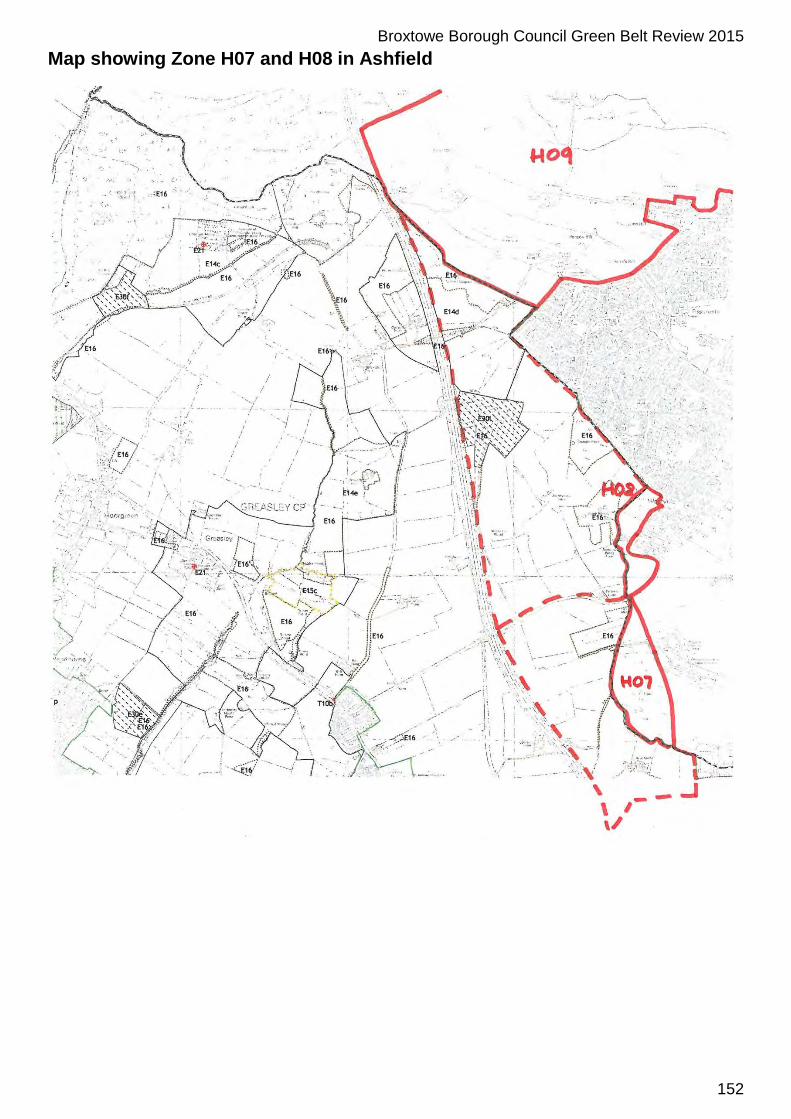
Broxtowe Borough Council Green Belt Review 2015 Map showing Zone H07 and H08 in Ashfield
152
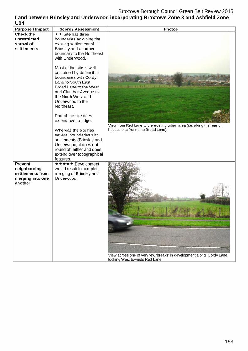
Broxtowe Borough Council Green Belt Review 2015 Land between Brinsley and Underwood incorporating Broxtowe Zone 3 and Ashfield Zone U04 Purpose / Impact Score / Assessment Photos Check the unrestricted sprawl of settlements
Site has three boundaries adjoining the existing settlement of Brinsley and a further boundary to the Northeast with Underwood. Most of the site is well contained by defensible boundaries with Cordy Lane to South East, Broad Lane to the West and Clumber Avenue to the North West and Underwood to the Northeast. Part of the site does extend over a ridge. Whereas the site has several boundaries with settlements (Brinsley and Underwood) it does not round off either and does extend over topographical features.
View from Red Lane to the existing urban area (i.e. along the rear of houses that front onto Broad Lane).
Prevent neighbouring settlements from merging into one another
Development would result in complete merging of Brinsley and Underwood.
View across one of very few ‘breaks’ in development along Cordy Lane looking West towards Red Lane
153

Broxtowe Borough Council Green Belt Review 2015
Assist in safeguarding the countryside from encroachment
There are a number of residential properties located within the Green Belt on Cordy Lane (in Broxtowe and Ashfield), Red Lane and around the periphery of the site. There is a transport depot within the site on Winter Closes. Some telegraph poles but largely has the feel of ‘open countryside’ albeit that there is quite a hard edge to the existing built up area of Brinsley.
View from Red Lane towards East
Preserve the setting and special character of historic settlements
The site would have little/no impact on the Conservation Area or Listed Buildings, the site is located at the opposite end of the village to the Conservation Area and its development would be hidden from the Conservation Area and Listed Buildings by the existing built up area.
Assist in urban regeneration
It is considered that all sites in the Green Belt assist in urban regeneration. This is not considered to be a matter of difference between Green Belt sites and therefore this Green Belt purpose is not scored as part of the Framework.
154

Broxtowe Borough Council Green Belt Review 2015 Land West of Hucknall incorporating Broxtowe Zone 22 and Ashfield Zone H08 Purpose / Impact Score / Assessment Photos Check the unrestricted sprawl of settlements
The site is partially contained with Hucknall to the east, Long Lane to the South and the M1 motorway to the West. The site is open countryside with no obvious defensible boundary to the north.
View from north of Long Lane looking back towards the east.
Prevent neighbouring settlements from merging into one another
Development would reduce the gap to a moderate extent between the west of Hucknall and north of Kimberley with some reduction in the gap between Hucknall and Eastwood. The M1 has an influence on the perceived reduction of this gap.
View towards the western edge of Hucknall.
Assist in safeguarding the countryside from encroachment
The site contains power lines, mobile phone masts, sporadic housing development and Watnall Brickworks. However the site retains a rural open character despite the inappropriate development within it.
View looking north towards Long Lane showing mobile phone mast.
155

Broxtowe Borough Council Green Belt Review 2015 Preserve the setting and special character of historic settlements
No heritage assets.
Assist in urban regeneration
It is considered that all sites in the Green Belt assist in urban regeneration. This is not considered to be a matter of difference between Green Belt sites and therefore this Green Belt purpose is not scored as part of the Framework.
156

Broxtowe Borough Council Green Belt Review 2015 Land between Hucknall and Bulwell incorporating Broxtowe Zone 23 and Ashfield Zone H07 Purpose / Impact
Score / Assessment Photos
Check the unrestricted sprawl of settlements
Although the site is reasonably well contained with Long Lane to the North, The Rolls Royce allocated site In Ashfield together with Bulwell Wood and the Blenheim Industrial estate in Nottingham to the east, the majority of the site is not visually connected to the existing urban area due to Bulwell Wood. The site is partly contained by the M1 to the west and a dismantled railway line to the south. However there would be no rounding off and the site is adjacent to and between Hucknall and Nottingham.
Looking East with Long Lane to the right (south) of the picture.
Prevent neighbouring settlements from merging into one another
The site would result in the complete merging of Hucknall (Rolls Royce allocated site in Ashfield) and Nottingham.
View from near the motorway towards Bulwell Wood with Blenheim Industrial estate to the south and the Rolls Royce site further north (out of picture)
157

Broxtowe Borough Council Green Belt Review 2015 Assist in safeguarding the countryside from encroachment
The site contains the western edge of the Rolls Royce site, an electricity substation towards the M1 Motorway and farm buildings which collectively have caused some less than moderate encroachment for the site as a whole. The site is generally open countryside.
View north looking at the western edge of the hardstanding on the Rolls Royce site the majority of which is in Ashfield.
Preserve the setting and special character of historic settlements
No heritage assets.
Assist in urban regeneration
It is considered that all sites in the Green Belt assist in urban regeneration. This is not considered to be a matter of difference between Green Belt sites and therefore this Green Belt purpose is not scored as part of the Framework.
158

Broxtowe Borough Council Green Belt Review 2015
Appendix C: Cross Boundary Assessments with Nottingham City
159

Broxtowe Borough Council Green Belt Review 2015 Cross Boundary Zones between Nottingham and Broxtowe
1b. Bulwell West - small area of Green Belt to west of Seller’s Wood Drive West in Nottingham and Broxtowe Zone 24
2a. South/West of Nuthall – Business Park in Nottingham and Broxtowe Zone 26 2b. Bilborough – West of Bilborough Road in Nottingham and Broxtowe Zone 27 3a. West of Clifton in Nottingham and Zone 45 in Broxtowe
3a
2b
2a
1b
160

Broxtowe Borough Council Green Belt Review 2015 Land between Nottingham Road Nuthall, Long Lane and Sellers Wood Drive West incorporating Broxtowe Zone 24 and Nottingham City Zone 1b Purpose / Impact
Score / Assessment Photos
Check the unrestricted sprawl of settlements
The site is partially contained with the main built up area to the east, Nottingham Road to the South and the M1 motorway to the West. The dismantled railway and Blenheim Industrial Estate also form a partial boundary to the site to the North. The site is open countryside.
View looking south towards Nottingham Road.
Prevent neighbouring settlements from merging into one another
Development towards the south of the site would result in the near total merging of the built up areas of Nottingham to the east and Kimberley to the west. If development were contained to the majority of the site further north then this total merging would be avoided albeit there would still be a significant reduction in the gap between the main built up areas of Nottingham and Kimberley.
View south of the M1 footbridge looking SE towards Greater Nottingham.
Assist in safeguarding the countryside from encroachment
The site contains power lines, mobile phone masts, a ribbon of housing development on Nottingham Road, high fencing around a wooded area, industrial area in Bulwell which is not in the Green Belt but has some urbanising influence, however the site retains a rural open character despite the inappropriate development within it
View east over M1 motorway showing industrial areas in Greater Nottingham.
161

Broxtowe Borough Council Green Belt Review 2015 Preserve the setting and special character of historic settlements
No heritage assets.
Assist in urban regeneration
It is considered that all sites in the Green Belt assist in urban regeneration. This is not considered to be a matter of difference between Green Belt sites and therefore this Green Belt purpose is not scored as part of the Framework.
162
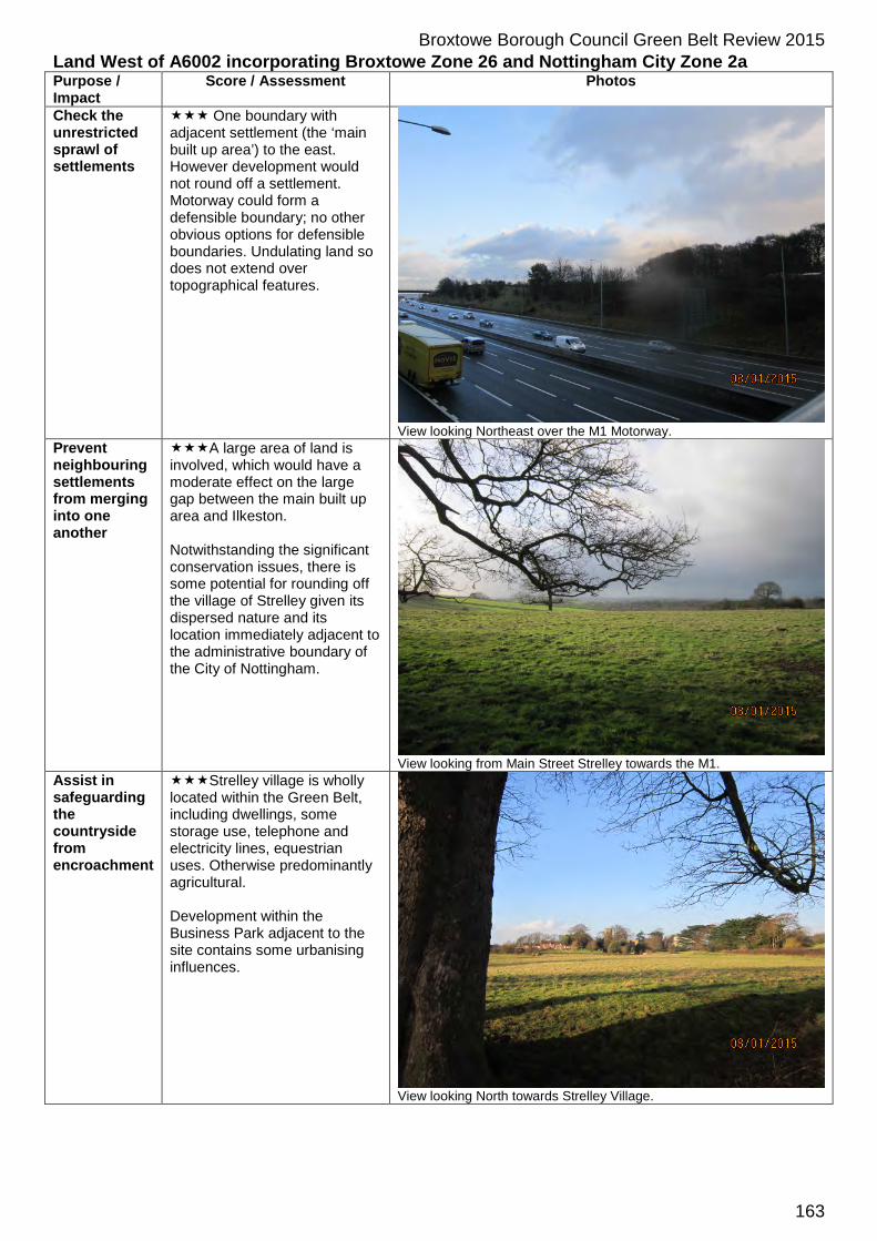
Broxtowe Borough Council Green Belt Review 2015 Land West of A6002 incorporating Broxtowe Zone 26 and Nottingham City Zone 2a Purpose / Impact
Score / Assessment Photos
Check the unrestricted sprawl of settlements
One boundary with adjacent settlement (the ‘main built up area’) to the east. However development would not round off a settlement. Motorway could form a defensible boundary; no other obvious options for defensible boundaries. Undulating land so does not extend over topographical features.
View looking Northeast over the M1 Motorway.
Prevent neighbouring settlements from merging into one another
A large area of land is involved, which would have a moderate effect on the large gap between the main built up area and Ilkeston. Notwithstanding the significant conservation issues, there is some potential for rounding off the village of Strelley given its dispersed nature and its location immediately adjacent to the administrative boundary of the City of Nottingham.
View looking from Main Street Strelley towards the M1.
Assist in safeguarding the countryside from encroachment
Strelley village is wholly located within the Green Belt, including dwellings, some storage use, telephone and electricity lines, equestrian uses. Otherwise predominantly agricultural. Development within the Business Park adjacent to the site contains some urbanising influences.
View looking North towards Strelley Village.
163

Broxtowe Borough Council Green Belt Review 2015 Preserve the setting and special character of historic settlements
No significant impact on assets within the main built up area. Would affect the setting of Strelley Conservation Area, the church and other listed buildings and Scheduled Monuments, however these are within the Green Belt in Broxtowe and are distinct from the main built up area. Part of Strelley Conservation Area is within the Nottingham City area and there would potentially be a moderate adverse impact.
View of Grade I Listed Strelley Church of All Saints from the South.
Assist in urban regeneration
It is considered that all sites in the Green Belt assist in urban regeneration. This is not considered to be a matter of difference between Green Belt sites and therefore this Green Belt purpose is not scored as part of the Framework.
164

Broxtowe Borough Council Green Belt Review 2015 Land at Trowell Moor adjacent to Bilborough in Nottingham incorporating Broxtowe Zone 27 and Nottingham City Zone 2b Purpose / Impact
Score / Assessment Photos
Check the unrestricted sprawl of settlements
Single boundary with adjacent main built up area. Not well contained and would not round off a settlement. Motorway could form a defensible boundary to the west; however this would involve releasing a very large site. Alternatively, higher land part way between the A6002 and the motorway might form the basis of a defensible boundary. A609 would form a defensible boundary to the south. (If the motorway were used as a boundary, the released site would extend over the topographical feature of this higher land.)
View Southeast towards Nottingham. Prevent neighbouring settlements from merging into one another
A large area of land is involved, which, if the higher land were used as a boundary, would have a moderate effect on the large gap between the main built up area and Ilkeston/Trowell. (If the motorway were used as a boundary, the ‘score’ would be.)
View Southeast towards Nottingham.
Assist in safeguarding the countryside from encroachment
The site has some inappropriate development including the motorway services, a man-made reservoir, caravan storage, several dwellings and commercial uses along the A6002 and A609 around the periphery of the site, and some equestrian uses. Otherwise predominantly agricultural.
View of man-made reservoir from the South.
Preserve the setting and special
A limited amount of inter-visibility with Wollaton Hall, adjacent to the main built up area. Would affect the setting of Strelley Conservation Area, the church and other listed buildings and
165

Broxtowe Borough Council Green Belt Review 2015 character of historic settlements
Scheduled Monuments, however these are within the Green Belt in Broxtowe and are distinct from the main built up area. Part of Strelley Conservation Area is within the Nottingham City area and there would potentially be a moderate adverse impact.
Assist in urban regeneration
It is considered that all sites in the Green Belt assist in urban regeneration. This is not considered to be a matter of difference between Green Belt sites and therefore this Green Belt purpose is not scored as part of the Framework.
166

Broxtowe Borough Council Green Belt Review 2015 Land between Beeston Rylands, Attenborough and Clifton incorporating Broxtowe Zone 45 and Nottingham City Zone 3a Purpose / Impact
Score / Assessment Photos
Check the unrestricted sprawl of settlements
Although the north west boundary adjoins the settlement of Beeston Rylands and the Southeast boundary adjoins the settlement of Clifton the River Trent bisects the site and could form a defensible boundary on either side. Notwithstanding this there would be only a minimal sense of rounding off either settlement given that the site is separated from Beeston Rylands by the canal and steep topography to the West of Clifton. To the north (and east) of Clifton would significantly add to urban sprawl in this sensitive valley.
Looking Northeast from footpath next to the Canal.
Prevent neighbouring settlements from merging into one another
Development would result in near total merging between Beeston and Clifton at the West of the site, between Clifton and Wilford / West Bridgford at the North and between Clifton and Ruddington at the East.
Looking Northeast to the footpath next to the canal.
Assist in safeguarding the countryside from encroachment
The site is almost entirely given over to open recreational land on the Beeston side, although there are large electricity pylons, Flood defences and some parking sites. There are major roads bisecting the site on the Clifton side. Parts of the site have the character of urban fringe.
Looking Southeast towards Clifton.
167

Broxtowe Borough Council Green Belt Review 2015 Preserve the setting and special character of historic settlements
There would be more than moderate adverse impact on the setting of Clifton Hall and the Conservation Area in Clifton village on the Nottingham side of the River Trent.
There would also be an impact on the Listed Buildings within the Boots site, however this would be to a lesser extent given the existing industrial setting of the buildings.
View North along the Canal.
Assist in urban regeneration
It is considered that all sites in the Green Belt assist in urban regeneration. This is not considered to be a matter of difference between Green Belt sites and therefore this Green Belt purpose is not scored as part of the Framework.
168
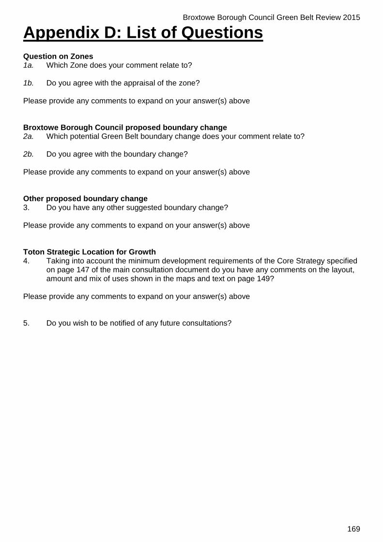
Broxtowe Borough Council Green Belt Review 2015
Appendix D: List of Questions Question on Zones 1a. Which Zone does your comment relate to? 1b. Do you agree with the appraisal of the zone? Please provide any comments to expand on your answer(s) above Broxtowe Borough Council proposed boundary change 2a. Which potential Green Belt boundary change does your comment relate to? 2b. Do you agree with the boundary change? Please provide any comments to expand on your answer(s) above Other proposed boundary change 3. Do you have any other suggested boundary change? Please provide any comments to expand on your answer(s) above Toton Strategic Location for Growth 4. Taking into account the minimum development requirements of the Core Strategy specified
on page 147 of the main consultation document do you have any comments on the layout, amount and mix of uses shown in the maps and text on page 149?
Please provide any comments to expand on your answer(s) above 5. Do you wish to be notified of any future consultations?
169

Broxtowe Borough CouncilLegal and Planning ServicesCouncil Offices, Foster Avenue,Beeston, Nottingham NG9 1ABTel: 0115 917 7777 Fax: 0115 917 3377Email: [email protected]
Follow Broxtowe with social mediaKeep up-to-date with the latest Council news, jobs and activities in your area by following Broxtowe Borough Council on your favourite social networking sites.
www.broxtowe.gov.uk/socialmedia