Embed Size (px)
Citation preview
INLAND WATERWAYS AUTHORITY OF INDIA, A-13, SECTOR-1, NOIDA
DIST-GAUTAM BUDHA NAGAR, UTTAR PRADESH, PIN- 201 301(UP)
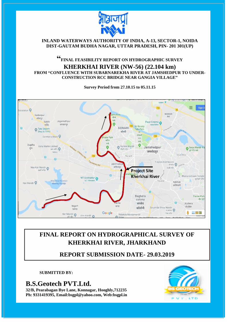
“FINAL FEASIBILITY REPORT ON HYDROGRAPHIC SURVEY
KHERKHAI RIVER (NW-56) (22.104 km) FROM “CONFLUENCE WITH SUBARNAREKHA RIVER AT JAMSHEDPUR TO UNDER-
CONSTRUCTION RCC BRIDGE NEAR GANGIA VILLAGE”
Survey Period from 27.10.15 to 05.11.15
SUBMITTED BY:
B.S.Geotech PVT.Ltd. 32/B, Pearabagan Bye Lane, Konnagar, Hooghly,712235
Ph: 9331419395, Email:[email protected], Web:bsgpl.in
FINAL REPORT ON HYDROGRAPHICAL SURVEY OF
KHERKHAI RIVER, JHARKHAND
REPORT SUBMISSION DATE- 29.03.2019
`

“ FINAL FEASIBILITY SURVEY REPORT IN KHERKHAI
RIVER , JHARKHAND (22.104 KM)”
Document History: Final Feasibility Report of River: Kherkhai, Jharkhand 2 | P a g e
Survey Period: From 27-10-15 to 05-11-15
Acknowledgement
B.S.Geotech PVT.Ltd, Konnagar, Hooghly express its sincere gratitude to IWAI for awarding the
work and guidance for completing this Project of detailed Hydrographic Survey and the Feasibility
Report in Region-VIII (Kherkhai River) from Confluence with Subarnarekha River at
Jamshedpur to under-construction RCC Bridge near Gangia Village (22.104 km).
We would like to use this opportunity to pen down our profound gratitude and appreciations to Shri
Jalaj Srivastava, IAS, Chairman, IWAI for spending their valuable time and guidance for
compleing this project of “ Detailed Hydrography and Topography survey in Kherkhai River.”
B.S.Geotech would also like to thanks to Shri Pravir Pandey, Vice-Chairman, IA&AS., Shri
Shashi Bhushan Shukla, Member (Traffic), Shri Alok Ranjan, Member (Finance) and Shri
S.K.Gangwar, Member (Technical).
B.S.Geotech wishes to express their gratitude to Capt. Ashish Arya, Hydrographic Chief, IWAI,
Cdr. P.K. Srivastava, Ex. Hydrographic Chief, IWAI, Shri S.V.K. Reddy, Chief Engineer-I for
his guidance and inspiration for this project. B.S.Geotech would also like to thank Shri Rajiv
Singhal, S.H.S., IWAI for invaluable support and suggestions provided throughout the survey period.
B.S.Geotech is pleased to place on record our sincere thanks to other staff and officers of IWAI for
their excellent support and co-operation throughout the survey period.
“ FINAL FEASIBILITY SURVEY REPORT IN KHERKHAI
RIVER , JHARKHAND (22.104 KM)”
Document History: Final Feasibility Report of River: Kherkhai, Jharkhand 3 | P a g e
Survey Period: From 27-10-15 to 05-11-15
List of Abbreviations
CD Chart Datum
DGPS Differential Global Positioning Systems
ETS Electronic Total Station
GPS Global Positioning Systems
LBM Local Bench Mark
MSL Mean Sea Level
RL Reference Level
SD Sounding Datum
SBAS Satellite-Based Augmentation System
TBC Trimble Business Centre
FRP Fiber Reinforced Plastic
Table 1- List of Abbreviations
“ FINAL FEASIBILITY SURVEY REPORT IN KHERKHAI
RIVER , JHARKHAND (22.104 KM)”
Document History: Final Feasibility Report of River: Kherkhai, Jharkhand 4 | P a g e
Survey Period: From 27-10-15 to 05-11-15
Table of Contents
Section-1: Introductory Considerations ........................................................................................................ 10
1.1- River Course: Background information, Historical Information, Origin, End:- .................................... 10
1.2 - Tributaries / Network of River/ Basin:- ................................................................................................... 11
1.3 - State / District through which river passes:- ............................................................................................. 11
1.4 – Project Site Location Map:- ...................................................................................................................... 11
1.5 - Scope of work:- ......................................................................................................................................... 12
Section-2: Methodology Adopted to undertake Study ................................................................................. 13
2.1 - Methodology Adopted including Resources and equipment used and calibration: - ................................ 13
2.2 - Description of Bench Marks (B.M) / authentic Reference Level used:- ................................................... 16
2.3 - Tidal Influence Zone and tidal variation in different stretches:- ............................................................... 17
2.4 - Methodology to fix Chart Datum/ Sounding Datum:- .............................................................................. 17
2.5 - Yearly minimum Water Levels Average of 06 years minimum Water Levels to arrive at Chart Datum
(CD) / Sounding Datum (SD):- ......................................................................................................................... 17
2.6 -Transfer of Sounding Datum table for Tidal Rivers:- ................................................................................ 17
2.7 –Table indicating tidal variation at different observation points (say at every 10 KM):- ........................... 17
2.8 - Salient features of Dam, Barrages, Weirs, Anicut, Locks, Aqueducts etc.:- ............................................. 17
2.9- Description of erected Bench mark Pillars:- .............................................................................................. 18
2.10- Description of erected Tide Gauges:- ....................................................................................................... 18
2.11- Chart Datum / Sounding Datum and Reductions details:- ....................................................................... 19
2.12- High Flood Level (H.F.L.) at known gauge stations and cross-structures:- ............................................. 20
2.13 - Average Slope:- ..................................................................................................................................... 20
2.14 - Details of Dam, Barrages, Weirs, Anicut, etc. w.r.t. MSL:- .................................................................. 20
2.15 - Details of Locks:- ................................................................................................................................ 20
2.16 - Details of Aqueducts:- ......................................................................................................................... 20
2.17- Details of existing Bridges and Crossings over waterway:- ..................................................................... 21
2.18 - Details of other Cross structures, pipe-lines, under water cables:- ......................................................... 21
2.19 - High Tension Lines / Electric lines / Tele-communication lines:- .......................................................... 22
2.20 - Current Meter and Discharge details:- .................................................................................................... 22
2.21 - (a) Soil Sample Locations:- ..................................................................................................................... 23
(b) Water Sample Locations:- ............................................................................................................................ 23
Section-3: Description of waterway .......................................................................................................... 24
3.1- From Chainage 0.00 Km to Chainage 10.00 Km. (Subarnarekha Confluence to Adityapur Colony):- ..... 24
3.2 - From Chainage 10.00 Km to Chainage 22.104 Km ( Adityapur Colony to Gangia village ):- ................. 30
Section 4: Terminals ........................................................................................................................................ 36
4.1 Details of Land use, owner etc:- .................................................................................................................. 36
Section 5: Fairway development:- .................................................................................................................. 37
Section 6: Conclusion ...................................................................................................................................... 41
6.1 Class wise Avg. Reduced Depths/Percentage:- ........................................................................................... 41
6.2 Range of Depths:- ........................................................................................................................................ 41
6.3 Min/Max and Avg. Width of Waterway:- ................................................................................................... 42
6.4 Dredging Summary:- ................................................................................................................................... 42
6.5 Avg. Slope:- ................................................................................................................................................. 42
“ FINAL FEASIBILITY SURVEY REPORT IN KHERKHAI
RIVER , JHARKHAND (22.104 KM)”
Document History: Final Feasibility Report of River: Kherkhai, Jharkhand 5 | P a g e
Survey Period: From 27-10-15 to 05-11-15
Annexure:- ........................................................................................................................................................ 43
Annexure-1 Source and type of data collected from various agencies:- ........................................................... 43
Annexure-2 Min. / max. depth, length of shoal per km-wise for different classification in the designed dredged
channel:- ............................................................................................................................................................ 43
Annexure-3 Details of collected Water level of different gauge stations w.r.t. MSL (CWC, Irrigation, Ports,
Maritime Boards, Observed stations during survey etc.) – Table indicating Chainage (zero at downstream) and
following:- ......................................................................................................................................................... 47
Annexure-4 Details of Bathymetric surveys carried out:- ................................................................................. 47
Annexure-5 Bank Protection along the Bank:- .................................................................................................. 48
Annexure-6 Details of Features across the Bank:- ............................................................................................ 48
Annexure-7 Detailed methodology adopted for carrying out survey. Horizontal Control and Vertical Details
Control:- ............................................................................................................................................................ 49
Annexure-8 Photographs of Equipment:- .......................................................................................................... 52
Annexure-9 Bench Mark Forms:- ...................................................................................................................... 55
Annexure-10 Levelling Calculation and Levelling Diagram: ........................................................................... 58
Annexure-11 Soil Sample Report: ..................................................................................................................... 61
Annexure-12 Water Sample Report: ................................................................................................................. 65
Annexure-13 Calibration Certificate:- ............................................................................................................... 69
Annexure-14 Site Picture:- ................................................................................................................................ 72
Annexure-15 Survey Charts:- ............................................................................................................................ 75
Lists of Figure
Figure 1- Kherkhai River site Location ............................................................................................................... 10
Figure 2-Project site location Map ...................................................................................................................... 11
Figure 3- During the Topography survey in the River bank area ........................................................................ 14
Figure 4- C.W.C Gauge area of Kherkhai River ................................................................................................. 16
Figure 5- Chainage 0.00 km to Chainage 10.00 km ............................................................................................ 24
Figure 6- Adityapur Toll Bridge (4.615 km) ....................................................................................................... 25
Figure 7- Adiyapur RCC Colony Bridge (Chainage-8.610 km and 8.636 km) ................................................... 25
Figure 8- Adityapur Colony Rail Bridge (Chainage- 9.197 km and 9.275 km) .................................................. 26
Figure 9- High Tension Line (Chainage-3.498 km) ............................................................................................ 26
Figure 10 – Chainage 10.00 km to Chainage 22.104 km .................................................................................... 30
Figure 11- Check Dam at Kalpatanga village (Chainage-10.642 km)................................................................. 31
Figure 12-Check Dam at Dudra village (Chainage-15.623 km) .......................................................................... 31
Figure 13-Under-Construction RCC Bridge (Chainage-16.724 km) ................................................................... 32
Figure 14-Under-Construction RCC Bridge (Chainage-22.104 km) ................................................................... 32
Figure 15- Proposed Terminal location of Adityapur colony area ...................................................................... 36
Figure 16- Topography Survey Instruments ........................................................................................................ 50
Figure 17- Bathymetry Survey Instruments ........................................................................................................ 51
Figure 18- Survey Vessel .................................................................................................................................... 52
Figure 19- DGPS Survey Instrument ................................................................................................................... 53
Figure 20- Echo Sounder Instrument ................................................................................................................... 53
Figure 21- Current Meter Reading ...................................................................................................................... 54
Figure 22- BM Form & Google image view of BM-1 ........................................................................................ 55
“ FINAL FEASIBILITY SURVEY REPORT IN KHERKHAI
RIVER , JHARKHAND (22.104 KM)”
Document History: Final Feasibility Report of River: Kherkhai, Jharkhand 6 | P a g e
Survey Period: From 27-10-15 to 05-11-15
Figure 23- BM Form & Google image view of BM-2 ........................................................................................ 56
Figure 24-BM Form & Google image view of BM-3 ......................................................................................... 57
Figure 25- Boulder pitching area ......................................................................................................................... 72
Figure 26- Health Centre ..................................................................................................................................... 73
Figure 27- River bank side area ........................................................................................................................... 73
Figure 28- Low water level in the river ............................................................................................................... 74
Figure 29-Check Dam near at Chainage 10.642 km ............................................................................................ 74
List of Table
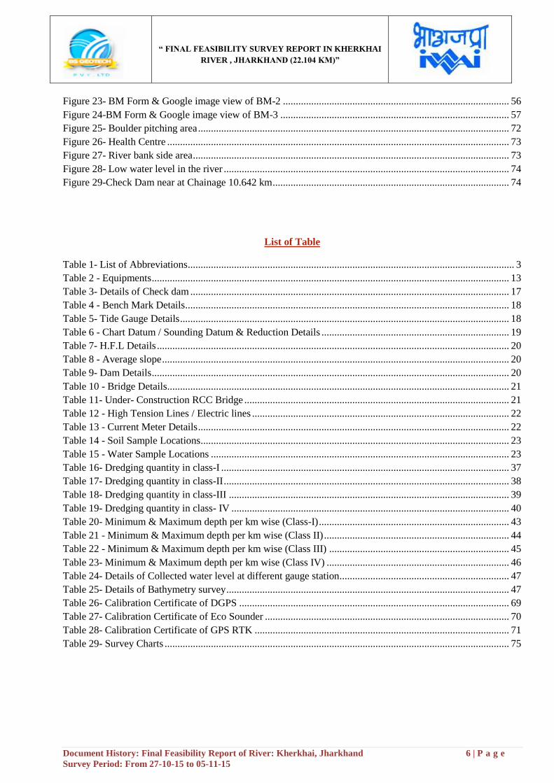
Table 1- List of Abbreviations ............................................................................................................................... 3
Table 2 - Equipments ........................................................................................................................................... 13
Table 3- Details of Check dam ............................................................................................................................ 17
Table 4 - Bench Mark Details .............................................................................................................................. 18
Table 5- Tide Gauge Details ................................................................................................................................ 18
Table 6 - Chart Datum / Sounding Datum & Reduction Details ......................................................................... 19
Table 7- H.F.L Details ......................................................................................................................................... 20
Table 8 - Average slope ....................................................................................................................................... 20
Table 9- Dam Details ........................................................................................................................................... 20
Table 10 - Bridge Details ..................................................................................................................................... 21
Table 11- Under- Construction RCC Bridge ....................................................................................................... 21
Table 12 - High Tension Lines / Electric lines .................................................................................................... 22
Table 13 - Current Meter Details ......................................................................................................................... 22
Table 14 - Soil Sample Locations ........................................................................................................................ 23
Table 15 - Water Sample Locations .................................................................................................................... 23
Table 16- Dredging quantity in class-I ................................................................................................................ 37
Table 17- Dredging quantity in class-II ............................................................................................................... 38
Table 18- Dredging quantity in class-III ............................................................................................................. 39
Table 19- Dredging quantity in class- IV ............................................................................................................ 40
Table 20- Minimum & Maximum depth per km wise (Class-I) .......................................................................... 43
Table 21 - Minimum & Maximum depth per km wise (Class II) ........................................................................ 44
Table 22 - Minimum & Maximum depth per km wise (Class III) ...................................................................... 45
Table 23- Minimum & Maximum depth per km wise (Class IV) ....................................................................... 46
Table 24- Details of Collected water level at different gauge station .................................................................. 47
Table 25- Details of Bathymetry survey .............................................................................................................. 47
Table 26- Calibration Certificate of DGPS ......................................................................................................... 69
Table 27- Calibration Certificate of Eco Sounder ............................................................................................... 70
Table 28- Calibration Certificate of GPS RTK ................................................................................................... 71
Table 29- Survey Charts ...................................................................................................................................... 75

“ FINAL FEASIBILITY SURVEY REPORT IN KHERKHAI
RIVER , JHARKHAND (22.104 KM)”
Document History: Final Feasibility Report of River: Kherkhai, Jharkhand 7 | P a g e
Survey Period: From 27-10-15 to 05-11-15
Salient Features of Kherkhai River
Sl. Particulars Details
1. Name of Consultant B.S. Geotech PVT. LTD
2. Region number & State(s) Region -VIII, Jharkhand
3. a) Waterway name
b) NW #
c) Total Stretch and length of
declared NW (from…. To….;
total length)
d) Survey Period (… to …)
a) Kherkhai River
b) NW-56
c) From Confluence with Subarnarekha River at Jamshedpur to
Under-construction RCC Bridge near Gangia village (22.104 km)
d) 27th October, 2015 to 05
th November, 2015
4. Tidal & non tidal portions
(from… to, length, average tidal
variation)
Non-Tidal River.
5.
LAD status (Least Available
Depth)
i) < 1.2 m (km)
ii) 1.2 m to 1.4 m (km)
iii) 1.5 m to 1.7 m (km)
iv) 1.8 m to 2.0 m (km)
v) > 2.0 m (km)
LAD status (Least Available
Depth)
i) < 1.2 m (km)
ii) 1.2 m to 1.4 m (km)
iii) 1.5 m to 1.7 m (km)
iv) 1.8 m to 2.0 m (km)
v) > 2.0 m (km)
Observed Depth
Sub Stretch-1
(0.00-10.00 km)
Sub Stretch-2
(10.00-22.104 km) Total
4.8 0.3 5.1
0 1.2 1.2
0 1.7 1.7
0 1.8 1.8
5.2 7.104 12.304
Total-10.00 Total- 12.104 Total- 22.104 km
Reduced Depth
Sub Stretch-1
(0.00-10.00 km)
Sub Stretch-2
(10.00-22.104 km) Total
6.6 0.7 7.3
0 1.2 1.2
0 1.7 1.7
0 1.9 1.9
3.4 6.604 10.004
Total-10.00 Total- 12.104 Total- 22.104 km
“ FINAL FEASIBILITY SURVEY REPORT IN KHERKHAI
RIVER , JHARKHAND (22.104 KM)”
Document History: Final Feasibility Report of River: Kherkhai, Jharkhand 8 | P a g e
Survey Period: From 27-10-15 to 05-11-15
Sl. Particulars Details
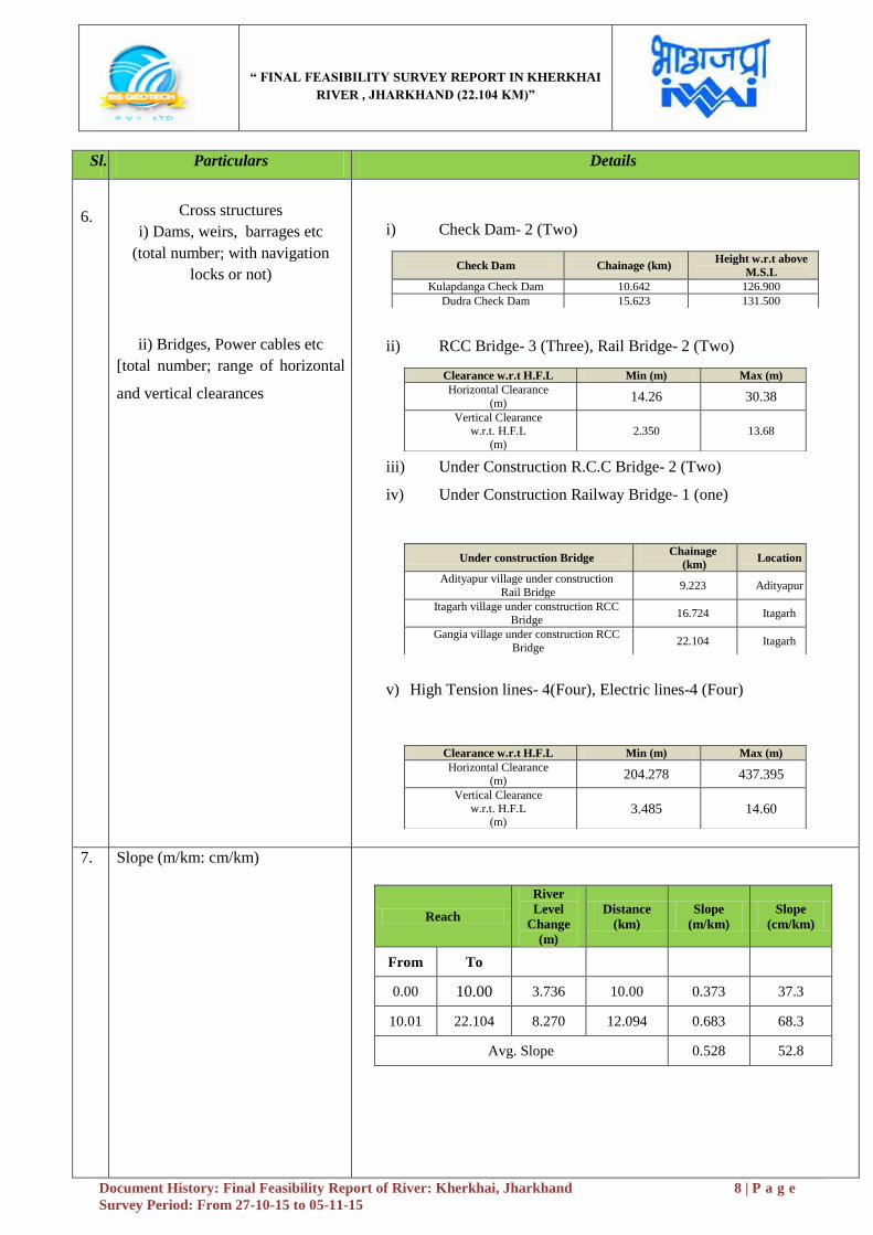
6.
Cross structures
i) Dams, weirs, barrages etc
(total number; with navigation
locks or not)
ii) Bridges, Power cables etc
[total number; range of horizontal
and vertical clearances
i) Check Dam- 2 (Two)
ii) RCC Bridge- 3 (Three), Rail Bridge- 2 (Two)
iii) Under Construction R.C.C Bridge- 2 (Two)
iv) Under Construction Railway Bridge- 1 (one)
v) High Tension lines- 4(Four), Electric lines-4 (Four)
Check Dam Chainage (km) Height w.r.t above
M.S.L
Kulapdanga Check Dam 10.642 126.900
Dudra Check Dam 15.623 131.500
Clearance w.r.t H.F.L Min (m) Max (m)
Horizontal Clearance
(m) 14.26 30.38
Vertical Clearance w.r.t. H.F.L
(m)
2.350 13.68
Under construction Bridge Chainage
(km) Location
Adityapur village under construction
Rail Bridge 9.223 Adityapur
Itagarh village under construction RCC Bridge
16.724 Itagarh
Gangia village under construction RCC
Bridge 22.104 Itagarh
Clearance w.r.t H.F.L Min (m) Max (m)
Horizontal Clearance (m)
204.278 437.395
Vertical Clearance
w.r.t. H.F.L (m)
3.485 14.60
7.
Slope (m/km: cm/km)
Reach
River
Level
Change
(m)
Distance
(km)
Slope
(m/km)
Slope
(cm/km)
From To
0.00 10.00 3.736 10.00 0.373 37.3
10.01 22.104 8.270 12.094 0.683 68.3
Avg. Slope 0.528 52.8
“ FINAL FEASIBILITY SURVEY REPORT IN KHERKHAI
RIVER , JHARKHAND (22.104 KM)”
Document History: Final Feasibility Report of River: Kherkhai, Jharkhand 9 | P a g e
Survey Period: From 27-10-15 to 05-11-15
Sl. Particulars Details
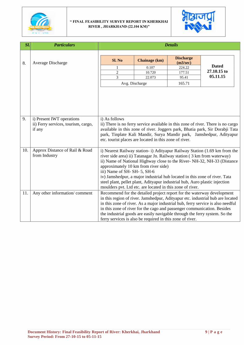
8.
Average Discharge
Sl. No Chainage (km) Discharge
(m3/sec) Dated
27.10.15 to
05.11.15
1 0.107 224.22
2 10.720 177.51
3 22.073 95.41
Avg. Discharge 165.71
9. i) Present IWT operations
ii) Ferry services, tourism, cargo,
if any
i) As follows
ii) There is no ferry service available in this zone of river. There is no cargo
available in this zone of river. Joggers park, Bhatia park, Sir Dorabji Tata
park, Tinplate Kali Mandir, Surya Mandir park, Jamshedpur, Adityapur
etc. tourist places are located in this zone of river.
10. Approx Distance of Rail & Road
from Industry i) Nearest Railway station- i) Adityapur Railway Station (1.69 km from the
river side area) ii) Tatanagar Jn. Railway station ( 3 km from waterway)
ii) Name of National Highway close to the River- NH-32, NH-33 (Distance
approximately 10 km from river side)
iii) Name of SH- SH- 5, SH-6
iv) Jamshedpur, a major industrial hub located in this zone of river. Tata
steel plant, pellet plant, Adityapur industrial hub, Auro plastic injection
moulders pvt. Ltd etc. are located in this zone of river.
11. Any other information/ comment Recommend for the detailed project report for the waterway development
in this region of river. Jamshedpur, Adityapur etc. industrial hub are located
in this zone of river. As a major industrial hub, ferry service is also needful
in this zone of river for the cago and passenger communication. Besides
the industrial goods are easily navigable through the ferry system. So the
ferry services is also be required in this zone of river.
“ FINAL FEASIBILITY SURVEY REPORT IN KHERKHAI
RIVER , JHARKHAND (22.104 KM)”
Document History: Final Feasibility Report of River: Kherkhai, Jharkhand 10 | P a g e
Survey Period: From 27-10-15 to 05-11-15
Section-1: Introductory Considerations
1.1- River Course: Background information, Historical Information, Origin, End:-
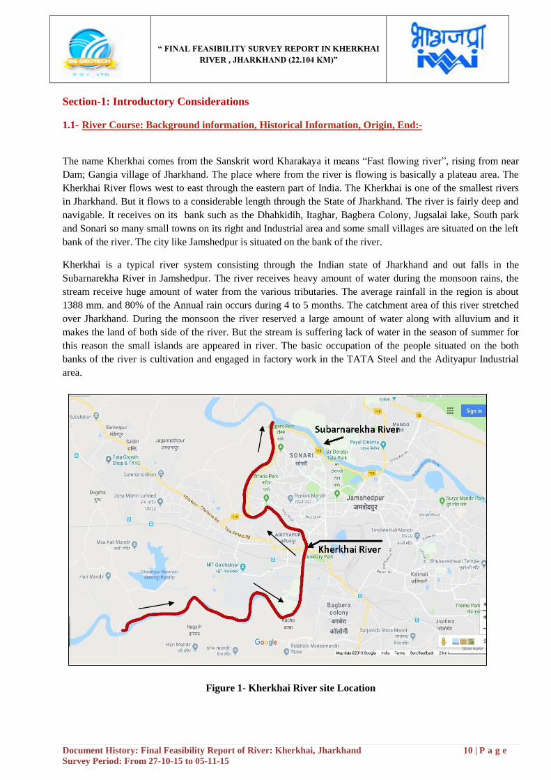
The name Kherkhai comes from the Sanskrit word Kharakaya it means “Fast flowing river”, rising from near
Dam; Gangia village of Jharkhand. The place where from the river is flowing is basically a plateau area. The
Kherkhai River flows west to east through the eastern part of India. The Kherkhai is one of the smallest rivers
in Jharkhand. But it flows to a considerable length through the State of Jharkhand. The river is fairly deep and
navigable. It receives on its bank such as the Dhahkidih, Itaghar, Bagbera Colony, Jugsalai lake, South park
and Sonari so many small towns on its right and Industrial area and some small villages are situated on the left
bank of the river. The city like Jamshedpur is situated on the bank of the river.
Kherkhai is a typical river system consisting through the Indian state of Jharkhand and out falls in the
Subarnarekha River in Jamshedpur. The river receives heavy amount of water during the monsoon rains, the
stream receive huge amount of water from the various tributaries. The average rainfall in the region is about
1388 mm. and 80% of the Annual rain occurs during 4 to 5 months. The catchment area of this river stretched
over Jharkhand. During the monsoon the river reserved a large amount of water along with alluvium and it
makes the land of both side of the river. But the stream is suffering lack of water in the season of summer for
this reason the small islands are appeared in river. The basic occupation of the people situated on the both
banks of the river is cultivation and engaged in factory work in the TATA Steel and the Adityapur Industrial
area.
Figure 1- Kherkhai River site Location
“ FINAL FEASIBILITY SURVEY REPORT IN KHERKHAI
RIVER , JHARKHAND (22.104 KM)”
Document History: Final Feasibility Report of River: Kherkhai, Jharkhand 11 | P a g e
Survey Period: From 27-10-15 to 05-11-15
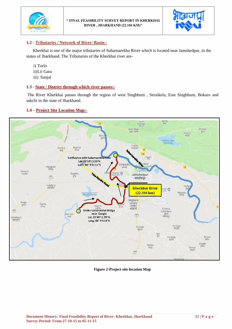
1.2 - Tributaries / Network of River/ Basin:-
Kherkhai is one of the major tributaries of Subarnarekha River which is located near Jamshedpur, in the
states of Jharkhand. The Tributaries of the Kherkhai river are-
i) Torlo
ii) Lii Gara
iii) Sanjal
1.3 - State / District through which river passes:-
The River Kherkhai passes through the region of west Singbhum , Seraikela, East Singbhum, Bokaro and
sakchi in the state of Jharkhand.
1.4 – Project Site Location Map:-
Figure 2-Project site location Map

“ FINAL FEASIBILITY SURVEY REPORT IN KHERKHAI
RIVER , JHARKHAND (22.104 KM)”
Document History: Final Feasibility Report of River: Kherkhai, Jharkhand 12 | P a g e
Survey Period: From 27-10-15 to 05-11-15
1.5 - Scope of work:-
The Scope of work shall cover all technical aspects of hydrographic survey at par with International
Standards including the following for development of the river/canal for inland navigation.
The detailed hydrographic survey is to be carried out by using Automated Hydrographic Survey System (using
digital Echo sounder for depth measurement, DGPS Beacons Receivers for position fixing and Hypackmax or
equivalent software for data logging). The survey is to be conducted in WGS‟84 datum.
Detailed Hydrographic Survey to assess the navigability of the waterway.
To collect Water and bottom samples, current meter observation and discharge from the deepest
route at every 10 km interval.
To identify cross structures which are obstructing navigation.
To identify the length of bank protection required.
The BM is denoted by a “.” mark engraved on a plate. The plate is fixed on a 5cm diameter GI
pipe. The GI pipe is cemented with construction pillar of 30cmX30cmX150cm.
The pillar extends 60.cms above ground level. Inscription “IWAI”, “B.S. Geotech” and BM No.
can be seen on the face of the pillar.
“ FINAL FEASIBILITY SURVEY REPORT IN KHERKHAI
RIVER , JHARKHAND (22.104 KM)”
Document History: Final Feasibility Report of River: Kherkhai, Jharkhand 13 | P a g e
Survey Period: From 27-10-15 to 05-11-15
Section-2: Methodology Adopted to undertake Study
2.1 - Methodology Adopted including Resources and equipment used and calibration: -
Equipment:-
Following equipments are employed for the Bathymetric and Topographic survey:-
Table 2 - Equipments
o Conduct of survey work
o Topography Survey:-
The Topography survey of Kherkhai River has been carried out from “Confluence with Subarnarekha River at
Jamshedpur (Lat: - 22°50'13.26"N, Long: - 86°09'37.11"E) to under-construction RCC Bridge near Gangia
village (Lat: - 22°45'11.99"N, Long: - 86°05'9.19"E)”. The Length of the topography survey is from Chainage
0.00 km to Chainage 22.104 km.
The Topography survey has been conducted to ascertain following in the survey area:-
- Spot levels
- High bank Line
- Vegetation covered
- Bridges and permanent structures
- Road, culvert and other communication network
GPS RTK (Real Time Kinematic) satellite navigation is a technique used in land survey and in hydrographic
survey based on the use of carrier phase measurements of the GPS, GLONASS and / or Galileo signals where
a single reference station provides the real-time corrections, providing up to centimeter-level accuracy. When
referring to GPS in particular, the system is also commonly referred to as Carrier-Phase Enhancement, CPGPS.
RTK systems use a single base station receiver and a number of mobile units. The base station re-broadcasts
the phase of the carrier that it measured, and the mobile units compare their own phase measurements with the
ones received from the base station. There are several ways to transmit a correction signal from base station to
mobile station. The most popular way to achieve real-time, low-cost signal transmission is to use a radio
modem, typically in the UHF band. This allows the units to calculate their relative position to millimeters,
although their absolute position is accurate only to the same accuracy as the position of the base station.
Equipment Make Version Qty
Employed
Echo sounder Bathy MF 500 ……… 1
Current Meter AEM 213-D ……… 1
Tide Gauge Manual (Pole type) ---------- 4
RTK South S86T ---------- 3
GPS Sets Trimble –Becon Receiver SPS 361 ---------- 1
Software HYPACK data acquisition Version 14 1
Software AUTOCAD 2013 1
Software Microsoft Office 2013 1

“ FINAL FEASIBILITY SURVEY REPORT IN KHERKHAI
RIVER , JHARKHAND (22.104 KM)”
Document History: Final Feasibility Report of River: Kherkhai, Jharkhand 14 | P a g e
Survey Period: From 27-10-15 to 05-11-15
o Establishment of Horizontal Control:-
The Horizontal control for Topography survey: - High precision RTK DGPS in fix mode is using UHF
Radio Modem with IHO accuracy standards, with minimum 24 hours observations at some permanent
platform/base. The survey was undertaken as per the line plan provided by IWAI office. The plotting of the
chart was done on UTM Projection at Zone 45 N /WGS-84 Datum as directed in the contract specifications.
The Horizontal control for Bathymetry survey: - DGPS is receiving corrections from Beacons from the
Base stations.
o Establishment of Vertical Control:-
Vertical control from C.W.C Gauge is used for the entire survey work. Its value is 123.00 meter w.r.t. M.S.L
has been considered for calculating the vertical levels. Total 3 no. Bench Mark was established along the
22.104 km of Kherkhai River with the reference of C.W.C Gauge which is situated near Adityapur Colony
area.
Topography Survey:-
The survey was commenced on 27th
October, 2015 and completed on 5th November, 2015. Then the days were
autumn season and arrival of winter season. The climate become normal which reached about 20◦ C. Mostly
day weather was sunny and was very favorable for the conduct of survey and the weather condition remains
same for the entire duration of the survey.
The survey was undertaken as per the line plan provided and the spot level points in the cross line were spaced
at 40 m interval. The plotting of the chart was done on UTM Projection at Zone 45 N as directed in the contract
specifications. The spot levels along the river were obtained by using Trimble DGPS. The data was post
processed using Trimble Business Center to get the precise position and MSL height values of the rover
locations. Topographic survey Equipments: South (S86T) GNSS RTK, Total Station was used for conducting
the topographic survey.
Figure 3- During the Topography survey in the River bank area
“ FINAL FEASIBILITY SURVEY REPORT IN KHERKHAI
RIVER , JHARKHAND (22.104 KM)”
Document History: Final Feasibility Report of River: Kherkhai, Jharkhand 15 | P a g e
Survey Period: From 27-10-15 to 05-11-15
Bathymetry Survey:-
Bathy 500 MF was used to obtain soundings onboard the survey boat. A working frequency of 210 KHz was
used for sounding operations. The digital output from the echo sounder was automatically fed to the HYPACK
data logging software on a real-time basis for the acquisition of survey data. No breakdown of equipment was
reported and the performance of the equipment was found to be satisfactory during the entire duration of the
survey.
The sound velocity was set to 1475 m/s on single beam echo sounder during acquisition by the Bar check
procedure method. The Daily bar checks were done prior to the sounding operation and before the closing of
the sounding operation for the day. Being very shallow depths, the echo sounder depths were also cross-
checked in between by using demarcated sounding poles during the conduct of the survey. The sounding lines
were run using Survey boat to identify the design line of the Kherkhai River for the possible stretch. The
sounding lines were run perpendicular to the orientation of river flow (i.e. perpendicular to the orientation of
depth contours) in respective stretches. The spot sounding was also carried out in the area where the survey
boat cannot be operated due to low depth. The hemisphere DGPS and Sounding Pole were used for Spot
sounding at shallow locations in the Kherkhai River. The DGPS position along with water depths was recorded
simultaneously and the tidal reduction was applied to the obtained depths.
Bathy- 500MF Echo sounder: The Bathy- 500MF Echo Sounder is an electronic hydrographic survey
instrument used for measuring depths with precision chart recordings and digital data output manufactured by
Syqwest Incorporated, USA. The Bathy-500 echo sounding systems are based on the principle that when a
sound signal is sent into the water it will be reflected back when it strikes an object. The Bathy-500 is
technologically sophisticated, utilizing modern, micro processor based electronics and a thermal chart recorder
mechanism. Digital processing enables the instrument to offer fully automatic digitizing capabilities. When
interfaced to a NMEA 0183 compatible position sensor, it provides user with a complete, integrated
hydrographic survey environment. The instrument front panel consists of a high contrast, backlit four line LCD
displays and a fully sealed input keypad. The front panel encompassing system data, status and setup
parameters with RS232/RS422 output format. All operating functions are set via the front panel interface.
Setup selections are stored within internal, non-volatile memory for instant availability upon power-up. The
instrument decodes and processes the NMEA 0183 formatted sentence GGA or GLL from GPS/DGPS using
variable Baud rates for communication.
“ FINAL FEASIBILITY SURVEY REPORT IN KHERKHAI
RIVER , JHARKHAND (22.104 KM)”
Document History: Final Feasibility Report of River: Kherkhai, Jharkhand 16 | P a g e
Survey Period: From 27-10-15 to 05-11-15
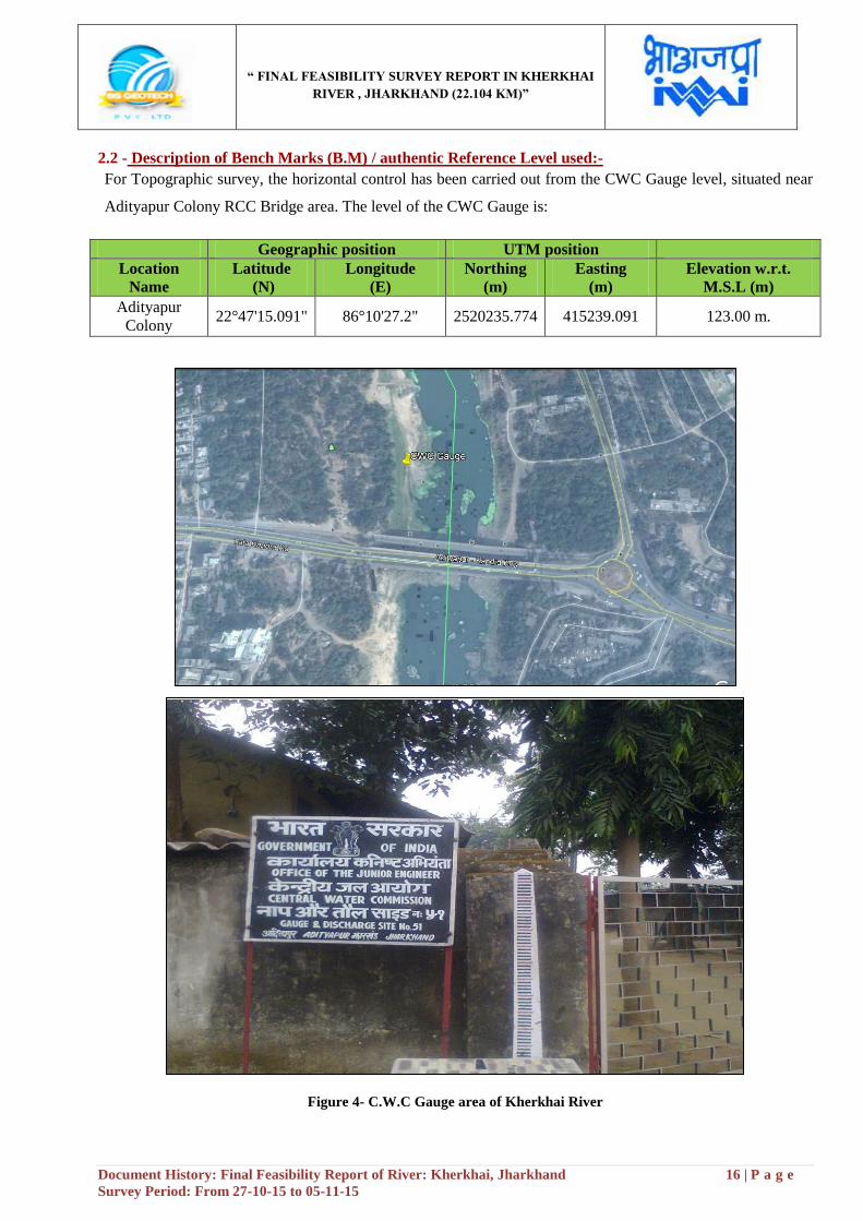
2.2 - Description of Bench Marks (B.M) / authentic Reference Level used:-
For Topographic survey, the horizontal control has been carried out from the CWC Gauge level, situated near
Adityapur Colony RCC Bridge area. The level of the CWC Gauge is:
Geographic position UTM position
Location
Name
Latitude
(N)
Longitude
(E)
Northing
(m)
Easting
(m)
Elevation w.r.t.
M.S.L (m)
Adityapur
Colony 22°47'15.091" 86°10'27.2" 2520235.774 415239.091 123.00 m.
Figure 4- C.W.C Gauge area of Kherkhai River

“ FINAL FEASIBILITY SURVEY REPORT IN KHERKHAI
RIVER , JHARKHAND (22.104 KM)”
Document History: Final Feasibility Report of River: Kherkhai, Jharkhand 17 | P a g e
Survey Period: From 27-10-15 to 05-11-15
2.3 - Tidal Influence Zone and tidal variation in different stretches:-
There are no Tidal influences or effects found in this zone of river.
2.4 - Methodology to fix Chart Datum/ Sounding Datum:-
IWAI had provided Sounding Datum at Adityapur and Confluence with Subarnarekha River. The same was
used to arrive the Sounding Datum values at BM Pillars and at tide gauges.
Sl.
No Place
Sounding Datum w.r.t MSL (Provided by
IWAI)
1 Adityapur (Chainage-8.697 km) 124.362 meter
2 Confluence with Subarnarekha River
(Chainage-0.00 km) 119.494 meter
2.5 - Yearly minimum Water Levels Average of 06 years minimum Water Levels to arrive at Chart
Datum (CD) / Sounding Datum (SD):-
The CD level of Adityapur (Chainage-8.697 km) in the river Kherkhai is 124.362 meter
The CD level of Confluence with Subarnarekha River (Chainage-0.00 km) is 119.494 meter
2.6 -Transfer of Sounding Datum table for Tidal Rivers:-
There is no tidal influence found in this zone of river.
2.7 –Table indicating tidal variation at different observation points (say at every 10 KM):-
There is no tidal influence found in this zone of river.
2.8 - Salient features of Dam, Barrages, Weirs, Anicut, Locks, Aqueducts etc.:-
There are two check Dams found in this zone of River.
Table 3- Details of Check dam
Chainage
Sl.
No
Struct
ure
Name
Chaina
ge
(km)
Location Latitude
(N)
Longitude
(E)
Northing
(m)
Easting
(m)
Length
(m)
Width
(m)
Height
w.r.t.
above
M.S.L
(m)
Prese
nt
Cond
ition
1 Check
Dam 10.642
Kulapdan
ga 22°46'6.32" 86°10'20.04" 2518122.20 415023.16 103.403 1.805
126.90
0
Comp
lete
2 Check
Dam 15.623 Dudra 22°45'33.921" 86°08'29.568" 2517143.73 411866.93 186.781
36.03
7
131.50
0
Comp
lete
“ FINAL FEASIBILITY SURVEY REPORT IN KHERKHAI
RIVER , JHARKHAND (22.104 KM)”
Document History: Final Feasibility Report of River: Kherkhai, Jharkhand 18 | P a g e
Survey Period: From 27-10-15 to 05-11-15
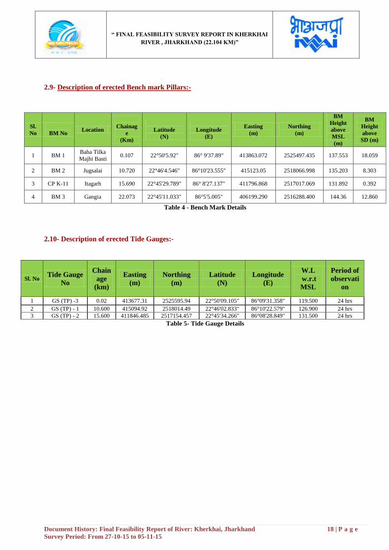
2.9- Description of erected Bench mark Pillars:-
Table 4 - Bench Mark Details
2.10- Description of erected Tide Gauges:-
Sl. No Tide Gauge
No
Chain
age
(km)
Easting
(m)
Northing
(m)
Latitude
(N)
Longitude
(E)
W.L
w.r.t
MSL
Period of
observati
on
1 GS (TP) -3 0.02 413677.31 2525595.94 22°50'09.105" 86°09'31.358" 119.500 24 hrs
2 GS (TP) - 1 10.600 415094.92 2518014.49 22°46'02.833" 86°10'22.579" 126.900 24 hrs
3 GS (TP) - 2 15.600 411846.485 2517154.457 22°45'34.266" 86°08'28.849" 131.500 24 hrs
Table 5- Tide Gauge Details
Sl.
No
BM No Location
Chainag
e
(Km)
Latitude
(N)
Longitude
(E)
Easting
(m)
Northing
(m)
BM
Height
above
MSL
(m)
BM
Height
above
SD (m)
1 BM 1 Baba Tilka
Majhi Basti 0.107 22°50'5.92" 86° 9'37.89" 413863.072 2525497.435 137.553 18.059
2 BM 2 Jugsalai 10.720 22°46'4.546" 86°10'23.555" 415123.05 2518066.998 135.203 8.303
3 CP K-11 Itagarh 15.690 22°45'29.789" 86° 8'27.137" 411796.868 2517017.069 131.892 0.392
4 BM 3 Gangia 22.073 22°45'11.033" 86°5'5.005" 406199.290 2516288.400 144.36 12.860
“ FINAL FEASIBILITY SURVEY REPORT IN KHERKHAI
RIVER , JHARKHAND (22.104 KM)”
Document History: Final Feasibility Report of River: Kherkhai, Jharkhand 19 | P a g e
Survey Period: From 27-10-15 to 05-11-15
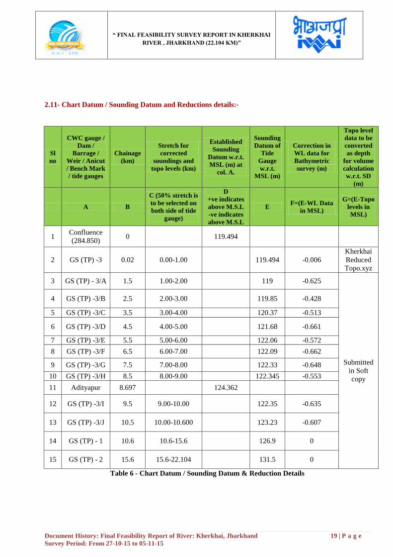
2.11- Chart Datum / Sounding Datum and Reductions details:-
Sl
no
CWC gauge /
Dam /
Barrage /
Weir / Anicut
/ Bench Mark
/ tide gauges
Chainage
(km)
Stretch for
corrected
soundings and
topo levels (km)
Established
Sounding
Datum w.r.t.
MSL (m) at
col. A.
Sounding
Datum of
Tide
Gauge
w.r.t.
MSL (m)
Correction in
WL data for
Bathymetric
survey (m)
Topo level
data to be
converted
as depth
for volume
calculation
w.r.t. SD
(m)
A B
C (50% stretch is
to be selected on
both side of tide
gauge)
D
+ve indicates
above M.S.L
-ve indicates
above M.S.L
E F=(E-WL Data
in MSL)
G=(E-Topo
levels in
MSL)
1 Confluence
(284.850) 0 119.494
2 GS (TP) -3 0.02 0.00-1.00 119.494 -0.006
Kherkhai
Reduced
Topo.xyz
3 GS (TP) - 3/A 1.5 1.00-2.00 119 -0.625
Submitted
in Soft
copy
4 GS (TP) -3/B 2.5 2.00-3.00 119.85 -0.428
5 GS (TP) -3/C 3.5 3.00-4.00 120.37 -0.513
6 GS (TP) -3/D 4.5 4.00-5.00 121.68 -0.661
7 GS (TP) -3/E 5.5 5.00-6.00 122.06 -0.572
8 GS (TP) -3/F 6.5 6.00-7.00 122.09 -0.662
9 GS (TP) -3/G 7.5 7.00-8.00 122.33 -0.648
10 GS (TP) -3/H 8.5 8.00-9.00 122.345 -0.553
11 Adityapur 8.697 124.362
12 GS (TP) -3/I 9.5 9.00-10.00 122.35 -0.635
13 GS (TP) -3/J 10.5 10.00-10.600 123.23 -0.607
14 GS (TP) - 1 10.6 10.6-15.6 126.9 0
15 GS (TP) - 2 15.6 15.6-22.104 131.5 0
Table 6 - Chart Datum / Sounding Datum & Reduction Details
“ FINAL FEASIBILITY SURVEY REPORT IN KHERKHAI
RIVER , JHARKHAND (22.104 KM)”
Document History: Final Feasibility Report of River: Kherkhai, Jharkhand 20 | P a g e
Survey Period: From 27-10-15 to 05-11-15
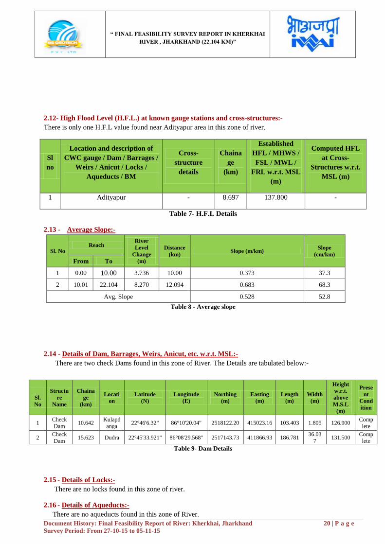
2.12- High Flood Level (H.F.L.) at known gauge stations and cross-structures:-
There is only one H.F.L value found near Adityapur area in this zone of river.
Sl
no
Location and description of
CWC gauge / Dam / Barrages /
Weirs / Anicut / Locks /
Aqueducts / BM
Cross-
structure
details
Chaina
ge
(km)
Established
HFL / MHWS /
FSL / MWL /
FRL w.r.t. MSL
(m)
Computed HFL
at Cross-
Structures w.r.t.
MSL (m)
1 Adityapur - 8.697 137.800 -
Table 7- H.F.L Details
2.13 - Average Slope:-
Sl. No Reach
River
Level
Change
(m)
Distance
(km) Slope (m/km)
Slope
(cm/km)
From To
1 0.00 10.00 3.736 10.00 0.373 37.3
2 10.01 22.104 8.270 12.094 0.683 68.3
Avg. Slope 0.528 52.8
Table 8 - Average slope
2.14 - Details of Dam, Barrages, Weirs, Anicut, etc. w.r.t. MSL:-
There are two check Dams found in this zone of River. The Details are tabulated below:-
Table 9- Dam Details
2.15 - Details of Locks:-
There are no locks found in this zone of river.
2.16 - Details of Aqueducts:-
There are no aqueducts found in this zone of River.
Chainage
Sl.
No
Structu
re
Name
Chaina
ge
(km)
Locati
on
Latitude
(N)
Longitude
(E)
Northing
(m)
Easting
(m)
Length
(m)
Width
(m)
Height
w.r.t.
above
M.S.L
(m)
Prese
nt
Cond
ition
1 Check
Dam 10.642
Kulapd
anga 22°46'6.32" 86°10'20.04" 2518122.20 415023.16 103.403 1.805 126.900
Comp
lete
2 Check
Dam 15.623 Dudra 22°45'33.921" 86°08'29.568" 2517143.73 411866.93 186.781
36.03
7 131.500
Comp
lete
“ FINAL FEASIBILITY SURVEY REPORT IN KHERKHAI
RIVER , JHARKHAND (22.104 KM)”
Document History: Final Feasibility Report of River: Kherkhai, Jharkhand 21 | P a g e
Survey Period: From 27-10-15 to 05-11-15
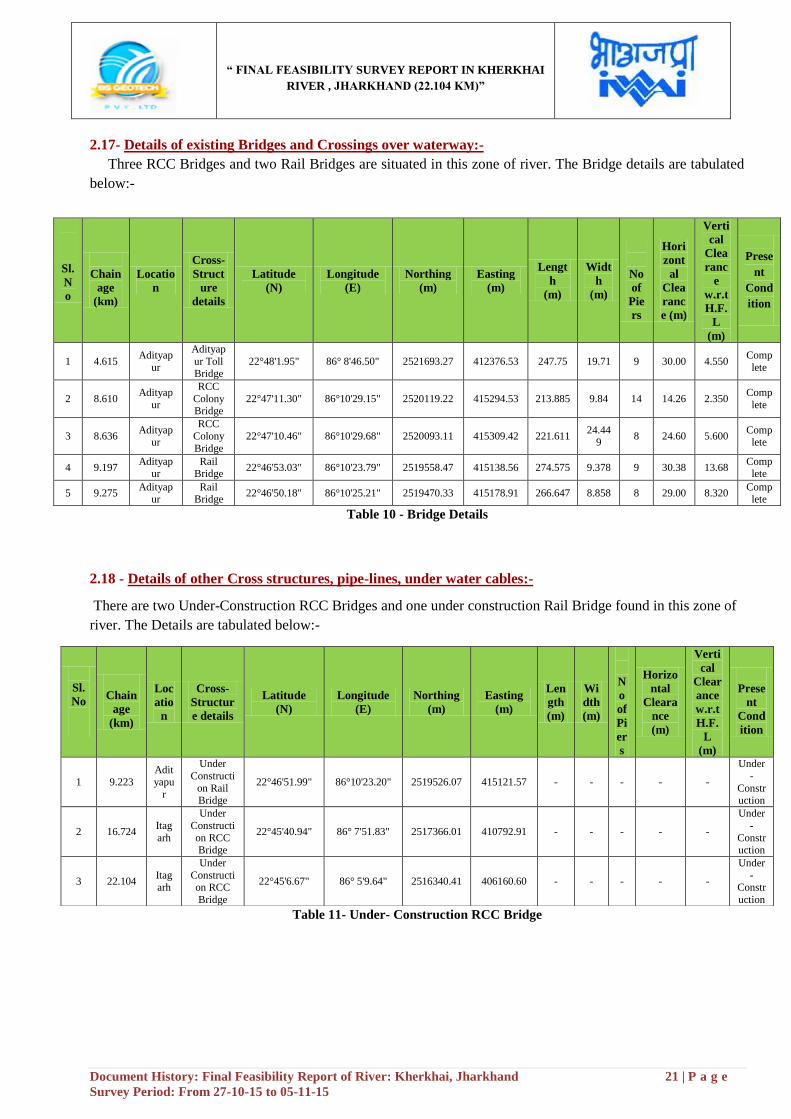
2.17- Details of existing Bridges and Crossings over waterway:-
Three RCC Bridges and two Rail Bridges are situated in this zone of river. The Bridge details are tabulated
below:-
Table 10 - Bridge Details
2.18 - Details of other Cross structures, pipe-lines, under water cables:-
There are two Under-Construction RCC Bridges and one under construction Rail Bridge found in this zone of
river. The Details are tabulated below:-
Table 11- Under- Construction RCC Bridge
Sl.
N
o
Chainage
Chain
age
(km)
Locatio
n
Cross-
Struct
ure
details
Latitude
(N)
Longitude
(E)
Northing
(m)
Easting
(m)
Lengt
h
(m)
Widt
h
(m)
No
of
Pie
rs
Hori
zont
al
Clea
ranc
e (m)
Verti
cal
Clea
ranc
e
w.r.t
H.F.
L
(m)
Prese
nt
Cond
ition
1 4.615 Adityap
ur
Adityap
ur Toll Bridge
22°48'1.95" 86° 8'46.50" 2521693.27 412376.53 247.75 19.71 9 30.00 4.550 Comp
lete
2 8.610 Adityap
ur
RCC
Colony Bridge
22°47'11.30" 86°10'29.15" 2520119.22 415294.53 213.885 9.84 14 14.26 2.350 Comp
lete
3 8.636 Adityap
ur
RCC
Colony
Bridge
22°47'10.46" 86°10'29.68" 2520093.11 415309.42 221.611 24.44
9 8 24.60 5.600
Complete
4 9.197 Adityap
ur Rail
Bridge 22°46'53.03" 86°10'23.79" 2519558.47 415138.56 274.575 9.378 9 30.38 13.68
Complete
5 9.275 Adityap
ur Rail
Bridge 22°46'50.18" 86°10'25.21" 2519470.33 415178.91 266.647 8.858 8 29.00 8.320
Complete
Sl.
No
Chainage
Chain
age
(km)
Loc
atio
n
Cross-
Structur
e details
Latitude
(N)
Longitude
(E)
Northing
(m)
Easting
(m)
Len
gth
(m)
Wi
dth
(m)
N
o
of
Pi
er
s
Horizo
ntal
Cleara
nce
(m)
Verti
cal
Clear
ance
w.r.t
H.F.
L
(m)
Prese
nt
Cond
ition
1 9.223 Adityapu
r
Under
Constructi
on Rail Bridge
22°46'51.99" 86°10'23.20" 2519526.07 415121.57 - - - - -
Under
-
Construction
2 16.724 Itag
arh
Under
Constructi
on RCC Bridge
22°45'40.94" 86° 7'51.83" 2517366.01 410792.91 - - - - -
Under
-
Construction
3 22.104 Itagarh
Under
Construction RCC
Bridge
22°45'6.67" 86° 5'9.64" 2516340.41 406160.60 - - - - -
Under
-Constr
uction
“ FINAL FEASIBILITY SURVEY REPORT IN KHERKHAI
RIVER , JHARKHAND (22.104 KM)”
Document History: Final Feasibility Report of River: Kherkhai, Jharkhand 22 | P a g e
Survey Period: From 27-10-15 to 05-11-15
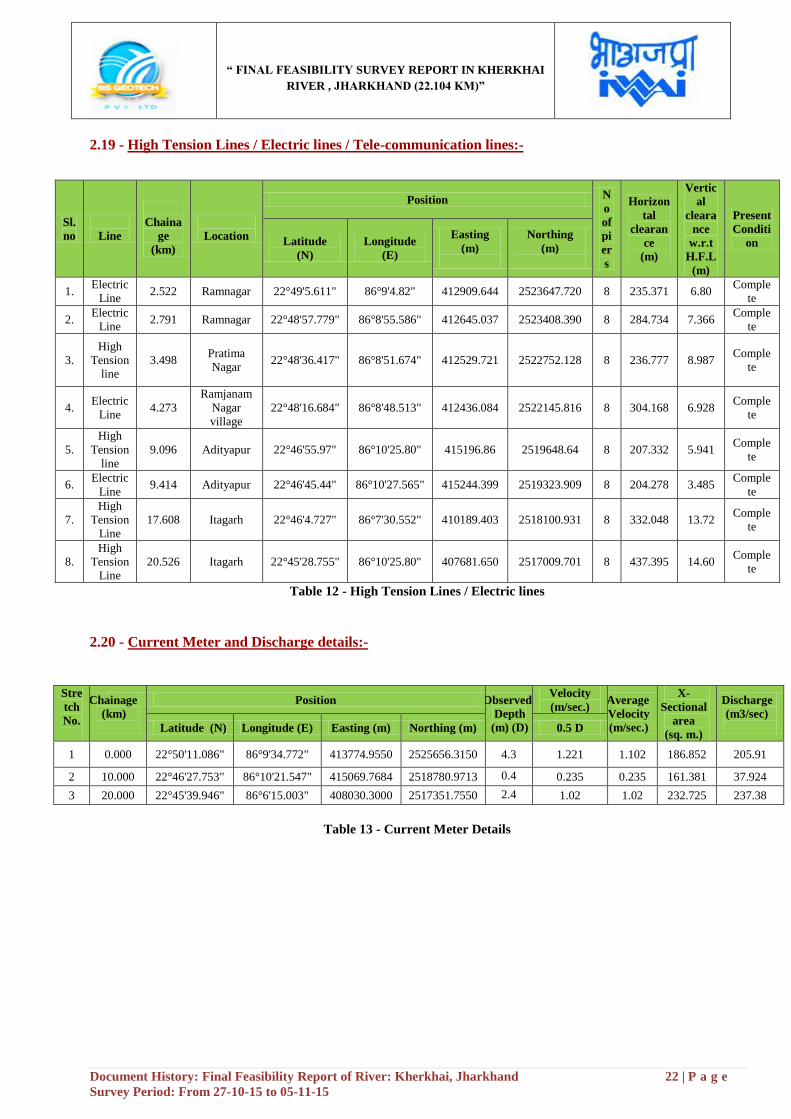
2.19 - High Tension Lines / Electric lines / Tele-communication lines:-
Table 12 - High Tension Lines / Electric lines
2.20 - Current Meter and Discharge details:-
Stre
tch
No.
Chainage
(km)
Position Observed
Depth
(m) (D)
Velocity
(m/sec.) Average
Velocity
(m/sec.)
X-
Sectional
area
(sq. m.)
Discharge
(m3/sec)
Latitude (N) Longitude (E) Easting (m) Northing (m) 0.5 D
1 0.000 22°50'11.086" 86°9'34.772" 413774.9550 2525656.3150 4.3 1.221 1.102 186.852 205.91
2 10.000 22°46'27.753" 86°10'21.547" 415069.7684 2518780.9713 0.4 0.235 0.235 161.381 37.924
3 20.000 22°45'39.946" 86°6'15.003" 408030.3000 2517351.7550 2.4 1.02 1.02 232.725 237.38
Table 13 - Current Meter Details
Sl.
no
Line
Chaina
ge
(km)
Location
Position N
o
of
pi
er
s
Horizon
tal
clearan
ce
(m)
Vertic
al
cleara
nce
w.r.t
H.F.L
(m)
Present
Conditi
on Latitude
(N)
Longitude
(E)
Easting
(m)
Northing
(m)
1. Electric
Line 2.522 Ramnagar 22°49'5.611" 86°9'4.82" 412909.644 2523647.720 8 235.371 6.80
Comple
te
2. Electric
Line 2.791 Ramnagar 22°48'57.779" 86°8'55.586" 412645.037 2523408.390 8 284.734 7.366
Comple
te
3.
High
Tension
line
3.498 Pratima
Nagar 22°48'36.417" 86°8'51.674" 412529.721 2522752.128 8 236.777 8.987
Comple
te
4. Electric
Line 4.273
Ramjanam
Nagar
village
22°48'16.684" 86°8'48.513" 412436.084 2522145.816 8 304.168 6.928 Comple
te
5.
High
Tension
line
9.096 Adityapur 22°46'55.97" 86°10'25.80" 415196.86 2519648.64 8 207.332 5.941 Comple
te
6. Electric
Line 9.414 Adityapur 22°46'45.44" 86°10'27.565" 415244.399 2519323.909 8 204.278 3.485
Comple
te
7.
High
Tension
Line
17.608 Itagarh 22°46'4.727" 86°7'30.552" 410189.403 2518100.931 8 332.048 13.72 Comple
te
8.
High
Tension
Line
20.526 Itagarh 22°45'28.755" 86°10'25.80" 407681.650 2517009.701 8 437.395 14.60 Comple
te
“ FINAL FEASIBILITY SURVEY REPORT IN KHERKHAI
RIVER , JHARKHAND (22.104 KM)”
Document History: Final Feasibility Report of River: Kherkhai, Jharkhand 23 | P a g e
Survey Period: From 27-10-15 to 05-11-15
2.21 - (a) Soil Sample Locations:-
Sample No. Chainage (km) Latitude (N) Longitude (E) Easting (m) Northing (m) Depth (m)
1 0.000 22°50'11.086" 86°9'34.772" 413774.9550 2525656.3150 4.3
2 10.000 22°46'27.753" 86°10'21.547" 415069.7684 2518780.9713 3.8
3 20.000 22°45'39.946" 86°6'15.003" 408030.3000 2517351.7550 0.6
Table 14 - Soil Sample Locations
Note: - The Soil Sample Report have been shown in Annexure-11, at page no-61
(b) Water Sample Locations:-
Sample No. Chainage
(km)
Latitude
(N)
Longitude
(E)
Easting
(m)
Northing
(m)
Total
Depth (d)
(m)
Mid-
Depth
(0.5d)
(m)
1 0.000 22°50'11.086" 86°9'34.772" 413774.9550 2525656.3150 4.3 2.15
2 10.000 22°46'27.753" 86°10'21.547" 415069.7684 2518780.9713 3.8 1.9
3 20.000 22°45'39.946" 86°6'15.003" 408030.3000 2517351.7550 0.6 0.3
Table 15 - Water Sample Locations
Note: - The water Sample Report have been shown in Annexure-12, at page no-65
“ FINAL FEASIBILITY SURVEY REPORT IN KHERKHAI
RIVER , JHARKHAND (22.104 KM)”
Document History: Final Feasibility Report of River: Kherkhai, Jharkhand 24 | P a g e
Survey Period: From 27-10-15 to 05-11-15
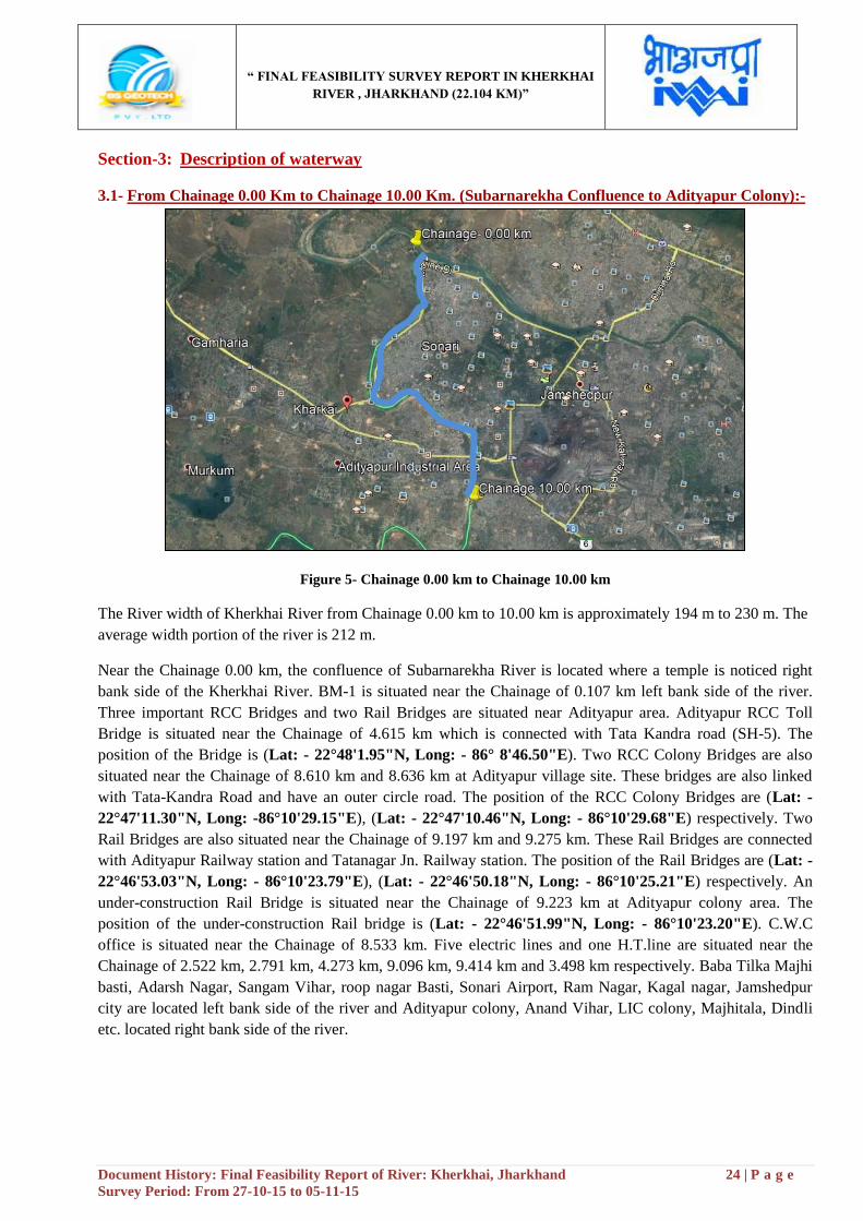
Section-3: Description of waterway
3.1- From Chainage 0.00 Km to Chainage 10.00 Km. (Subarnarekha Confluence to Adityapur Colony):-
Figure 5- Chainage 0.00 km to Chainage 10.00 km
The River width of Kherkhai River from Chainage 0.00 km to 10.00 km is approximately 194 m to 230 m. The
average width portion of the river is 212 m.
Near the Chainage 0.00 km, the confluence of Subarnarekha River is located where a temple is noticed right
bank side of the Kherkhai River. BM-1 is situated near the Chainage of 0.107 km left bank side of the river.
Three important RCC Bridges and two Rail Bridges are situated near Adityapur area. Adityapur RCC Toll
Bridge is situated near the Chainage of 4.615 km which is connected with Tata Kandra road (SH-5). The
position of the Bridge is (Lat: - 22°48'1.95"N, Long: - 86° 8'46.50"E). Two RCC Colony Bridges are also
situated near the Chainage of 8.610 km and 8.636 km at Adityapur village site. These bridges are also linked
with Tata-Kandra Road and have an outer circle road. The position of the RCC Colony Bridges are (Lat: -
22°47'11.30"N, Long: -86°10'29.15"E), (Lat: - 22°47'10.46"N, Long: - 86°10'29.68"E) respectively. Two
Rail Bridges are also situated near the Chainage of 9.197 km and 9.275 km. These Rail Bridges are connected
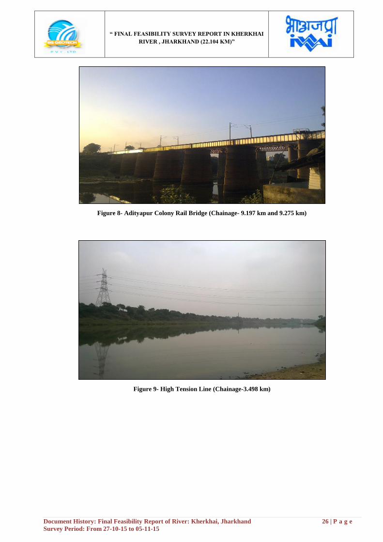
with Adityapur Railway station and Tatanagar Jn. Railway station. The position of the Rail Bridges are (Lat: -
22°46'53.03"N, Long: - 86°10'23.79"E), (Lat: - 22°46'50.18"N, Long: - 86°10'25.21"E) respectively. An
under-construction Rail Bridge is situated near the Chainage of 9.223 km at Adityapur colony area. The
position of the under-construction Rail bridge is (Lat: - 22°46'51.99"N, Long: - 86°10'23.20"E). C.W.C
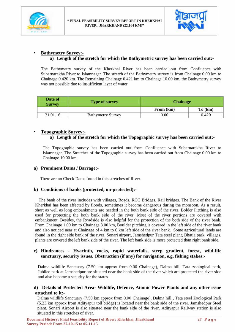
office is situated near the Chainage of 8.533 km. Five electric lines and one H.T.line are situated near the
Chainage of 2.522 km, 2.791 km, 4.273 km, 9.096 km, 9.414 km and 3.498 km respectively. Baba Tilka Majhi
basti, Adarsh Nagar, Sangam Vihar, roop nagar Basti, Sonari Airport, Ram Nagar, Kagal nagar, Jamshedpur
city are located left bank side of the river and Adityapur colony, Anand Vihar, LIC colony, Majhitala, Dindli
etc. located right bank side of the river.
“ FINAL FEASIBILITY SURVEY REPORT IN KHERKHAI
RIVER , JHARKHAND (22.104 KM)”
Document History: Final Feasibility Report of River: Kherkhai, Jharkhand 25 | P a g e
Survey Period: From 27-10-15 to 05-11-15
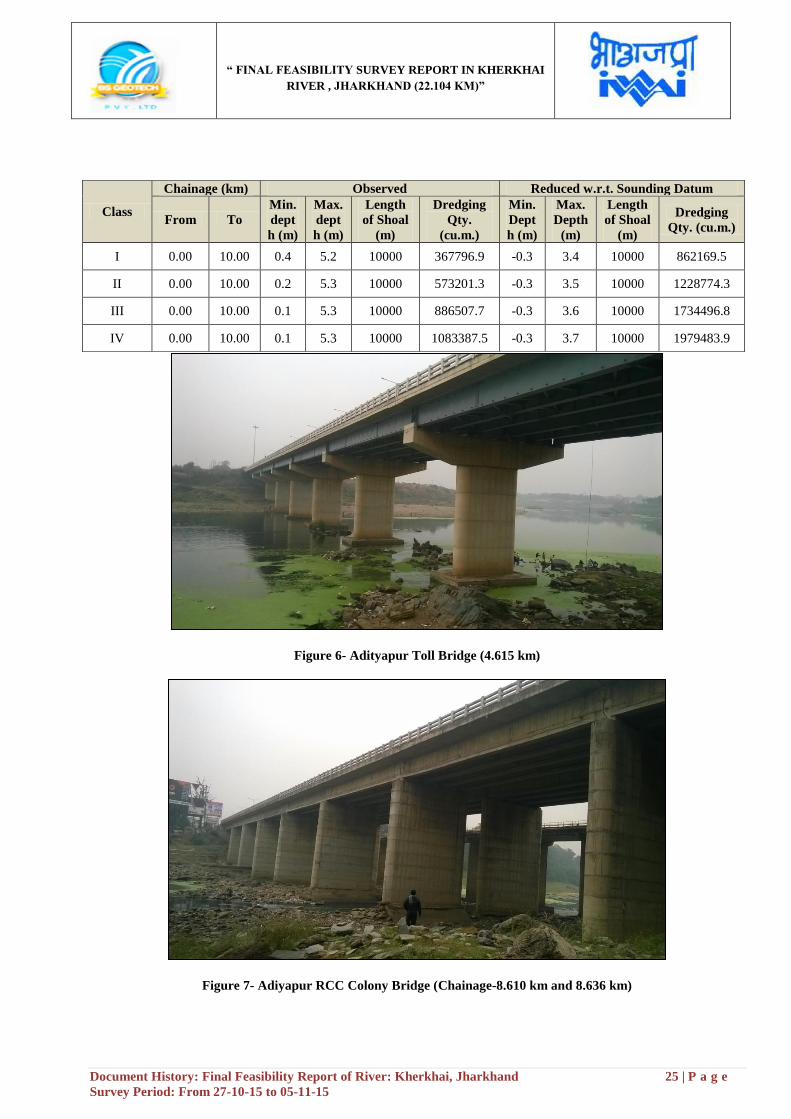
Figure 6- Adityapur Toll Bridge (4.615 km)
Figure 7- Adiyapur RCC Colony Bridge (Chainage-8.610 km and 8.636 km)
Class
Chainage (km) Observed Reduced w.r.t. Sounding Datum
From To
Min.
dept
h (m)
Max.
dept
h (m)
Length
of Shoal
(m)
Dredging
Qty.
(cu.m.)
Min.
Dept
h (m)
Max.
Depth
(m)
Length
of Shoal
(m)
Dredging
Qty. (cu.m.)
I 0.00 10.00 0.4 5.2 10000 367796.9 -0.3 3.4 10000 862169.5
II 0.00 10.00 0.2 5.3 10000 573201.3 -0.3 3.5 10000 1228774.3
III 0.00 10.00 0.1 5.3 10000 886507.7 -0.3 3.6 10000 1734496.8
IV 0.00 10.00 0.1 5.3 10000 1083387.5 -0.3 3.7 10000 1979483.9
“ FINAL FEASIBILITY SURVEY REPORT IN KHERKHAI
RIVER , JHARKHAND (22.104 KM)”
Document History: Final Feasibility Report of River: Kherkhai, Jharkhand 26 | P a g e
Survey Period: From 27-10-15 to 05-11-15
Figure 8- Adityapur Colony Rail Bridge (Chainage- 9.197 km and 9.275 km)
Figure 9- High Tension Line (Chainage-3.498 km)
“ FINAL FEASIBILITY SURVEY REPORT IN KHERKHAI
RIVER , JHARKHAND (22.104 KM)”
Document History: Final Feasibility Report of River: Kherkhai, Jharkhand 27 | P a g e
Survey Period: From 27-10-15 to 05-11-15
• Bathymetry Survey:-
a) Length of the stretch for which the Bathymetric survey has been carried out:-
The Bathymetry survey of the Kherkhai River has been carried out from Confluence with
Subarnarekha River to Islamnagar. The stretch of the Bathymetry survey is from Chainage 0.00 km to
Chainage 0.420 km. The Remaining Chainage 0.421 km to Chainage 10.00 km, the Bathymetry survey
was not possible due to insufficient layer of water.
Date of
Survey Type of survey Chainage
From (km) To (km)
31.01.16 Bathymetry Survey 0.00 0.420
• Topographic Survey:-
a) Length of the stretch for which the Topographic survey has been carried out:-
The Topographic survey has been carried out from Confluence with Subarnarekha River to
Islamnagar. The Stretches of the Topographic survey has been carried out from Chainage 0.00 km to
Chainage 10.00 km.
a) Prominent Dams / Barrage:-
There are no Check Dams found in this stretches of River.
b) Conditions of banks (protected, un-protected):-
The bank of the river includes with villages, Roads, RCC Bridges, Rail bridges. The Bank of the River
Kherkhai has been affected by floods, sometimes it become dangerous during the monsoon. As a result,
short as well as long embankments are needed in the both bank side of the river. Bolder Pitching is also
used for protecting the both bank side of the river. Most of the river portions are covered with
embankment. Besides, the Roadside is also helpful for the protection of the both side of the river bank.
From Chainage 1.00 km to Chainage 3.00 km, Boulder pitching is covered in the left side of the river bank
and also noticed near at Chainage of 4 km to 6 km left side of the river bank. Some agricultural lands are
found in the right side bank of the river. Sonari airport, Jamshedpur Tata steel plant, Bhatia park, villages,
plants are covered the left bank side of the river. The left bank side is more protected than right bank side.
c) Hindrances - Hyacinth, rocks, rapid waterfalls, steep gradient, forest, wild-life
sanctuary, security issues. Obstruction (if any) for navigation, e.g. fishing stakes:-
Dalma wildlife Sanctuary (7.50 km approx from 0.00 Chainage), Dalma hill, Tata zoological park,
Jubilee park at Jamshedpur are situated near the bank side of the river which are protected the river side
and also become a security for the states.
d) Details of Protected Area- Wildlife, Defence, Atomic Power Plants and any other issue
attached to it:- Dalma wildlife Sanctuary (7.50 km approx from 0.00 Chainage), Dalma hill , Tata steel Zoological Park
(5.23 km approx from Adityapur toll bridge) is located near the bank side of the river. Jamshedpur Steel
plant. Sonari Airport is also situated near the bank side of the river. Adityapur Railway station is also
situated in this stretches of river.
“ FINAL FEASIBILITY SURVEY REPORT IN KHERKHAI
RIVER , JHARKHAND (22.104 KM)”
Document History: Final Feasibility Report of River: Kherkhai, Jharkhand 28 | P a g e
Survey Period: From 27-10-15 to 05-11-15
e) NH/SH/MDR along and/or within 5 km from the waterways:-
NH-32 and NH-33 are situated approximately 10.00 km far from the river side which are the major
communication way in this zone of river. Besides, SH-5, SH-6 is also linked with NH-32 and NH-33
which communicate easily for the local villagers and also for the tourists.
f) Railway Line and Stations in the vicinity:- Two important Railway Bridges are passed over this river at Adityapur Colony area near at Chainage
of 9.197 km and 9.275 km. Adityapur Railway station is close to the river side. Besides Tatanagar Jn.
Railway station is located approximately 3.00 km from the river side.
g) Land Use Pattern along Waterway on visual assessment:- The bank side of the river is mainly used as an industrial hub. Jamshedpur, Adityapur etc. places are
situated near the bank side of the river. Adityapur industrial hub, Tata steel plant, Burma Mines and a
numbers of small industries are built up in this zone of river. Besides, the land is also used as zoological
park at Jamshedpur, some industrial plants and temple etc. Some agricultural lands are also found in this
zone of river.
h) Crops / Agriculture in the region on visual assessment:-
The major crops Paddy, jute, Tea, Rice, Wheat, Maize, Pulses, oilseeds and Spices are cultivated in this
region. Besides, fruits, vegetables, cashew nuts are also noticed in this zone of river.
i) Availability of Bulk / Construction Material:-
The availability of the construction materials is too easy for construction & any kind of structure. There
is some cement factories and brick fields located near Adityapur and Jamshedpur area. Burma Mines is
located approximately 4.25 km from the river side. The position of the Burma Mines is (Lat: -
22°46'7.66"N, Long: - 86°12'47.88"E) Iron ore is an important material found in this zone of river.
j) Existing Industries along Waterway with their types and details:-
Jamshedpur which is famous industrial hub situated in this zone of river at a distance of 3.86km from
Sonari Airport (Lat- 22°48'47.98"N, Long: - 86°10'9.92"E). Jamshedpur Steel plant, Adityapur industrial
area (Lat: - 22°47'9.36"N, Long: - 86° 9'54.48"E) are situated in this zone of river. Iron ore is an
important material located in this zone of river. Besides, some small kinds of industries are located near
Tatanagar, Sonari airport is situated near the bank side of this river. Auro Plastic Injection Moulders Pvt
Ltd (Lat- 22°48'7.94"N, Long: - 86° 7'17.83"E), Tata Steel Plant area (Lat: - 22°47'10.14"N, Long: -
86°11'52.95"E) are situated in this zone of river. Tatanagar Railway station is communicated well in this
zone of river.
k) Existing Ghats, Jetties and Terminals (with conditions and facilities). Existing navigation
facilities (if any):-
There is no Jetty service available in this stretches of river.
l) Existing Cargo Movement:- The cargo movement is generally processed through waterways system like Ferry services. There is no
ferry services found in this zone of river. So the cargo movement is unavailable in this zone of river.
“ FINAL FEASIBILITY SURVEY REPORT IN KHERKHAI
RIVER , JHARKHAND (22.104 KM)”
Document History: Final Feasibility Report of River: Kherkhai, Jharkhand 29 | P a g e
Survey Period: From 27-10-15 to 05-11-15
m) Prominent City / Town / Places of Worship / Historical places for Tourism:-
Adarsh Nagar, Adityapur, Sonari, Jamshedpur etc. importantcities are located in this stretches of river.
Dalma wildlife sanctuary and Dalma hills, Tata steel zoological park, Sir Dorabji Tata park, Jubilee park,
Dimna Lake, Hudco Lake, Bhatia Park , Joggers park, Surya Mandir park etc. are the important tourist
places situated in this zone of river. Tinplate kali mandir, shiv temple etc worship places are located in
this stretches of river.
n) Village / colonies along the sub-stretch and approx. Population:-
Adityapur Colony, Swastri Nagar, Goalpara, Baba Tilka Majhi Basti, Sangam Vihar, Jahira basti, Roop
Nagar Basti, Ramnagar, Gandhi Basti, Pratima Nagar, Bhatia Colony, Gwalpara, Ramjanam Nagar,
Swastri Nagar, Dindli, Kajal Nagar, Sonari, Raydih, Bhtrapur, Islamnagar, Hadgodam Basti, Paan
Dukaan chowk, Majhi tola, New Swarnarekha colony are located in this stretches of river.
o) Availability of Passenger Ferry Services with facilities and Annual movement data:- There is no Passenger ferry service available in this zone of river.
p) Available and probable Water Sport Recreational Facilities:-
There are no water sport recreational facilities available in this zone of river.
q) Fishing activities:-
Fish and fishing business in the river Subarnarekha and Kherkhai are an important sector in this region.
Cast nets, Scoop nets, Gill nets, Fishing lines, Tire tubes, make shift wooden platforms and Traditional
Bamboo Trap used for catching the fishes here. Fishing plays an important role in supporting livelihood
for the inhabitants of this Region. Fishes are one of the main occupations in this region of people where so
many people are engaged with this profession for the demand of fish.
r) Sand mining:-
The bank of the River Kherkhai is also used for the sand mines. The Sand Mining helps the people for
collection sand which is the major component for Building purposes. The Motor vehicles can easily collect
the sand and move for transportation. Sand Mines is an important sector where so many people are
engaged and these activities help them to get their daily livelihood. Besides this, sand is also exported to
other states as it becomes demandful for making Building or Industries. Sand mining contributes to the
construction of buildings and development. However, the negative effects of sand mining include the
permanent loss of sand in areas, as well as major habitat destruction.
s) Tributaries:- There is no tributary found in this stretches of river.
t) Details of Irrigation Canals and Outlets:- There is no irrigation canal and outlets found in this stretches of river.
u) Details of Nalas. Polluted water discharge in to the rivers and treatment plants (if any):- There are no Nalas found in this zone of river.
v) Usage of water (drinking, irrigation, industries, navigation etc.) Water quality:- The water of the river is used for cultivation and industrial purposes. The water is used in the industrial
hubs like Jamshedpur steel plant, Adityapur industrial hub and small kinds of industries. The water is used
as irrigation purposes. With the help of the irrigation system, the cultivation can easily accessible. As an
industry based area, the most of the quantities of water is used in the industry based activities.
“ FINAL FEASIBILITY SURVEY REPORT IN KHERKHAI
RIVER , JHARKHAND (22.104 KM)”
Document History: Final Feasibility Report of River: Kherkhai, Jharkhand 30 | P a g e
Survey Period: From 27-10-15 to 05-11-15
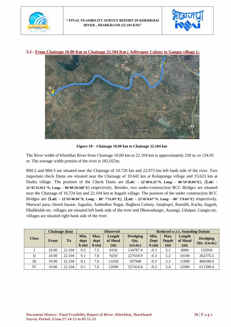
3.2 - From Chainage 10.00 Km to Chainage 22.104 Km ( Adityapur Colony to Gangia village ):-
Figure 10 – Chainage 10.00 km to Chainage 22.104 km
The River width of Kherkhai River from Chainage 10.00 km to 22.104 km is approximately 230 m. to 134.05
m. The average width portion of the river is 182.025m.
BM-2 and BM-3 are situated near the Chainage of 10.720 km and 22.073 km left bank side of the river. Two
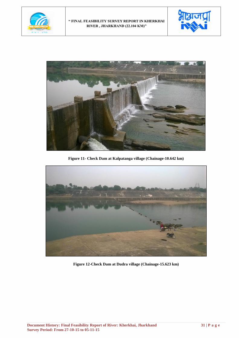
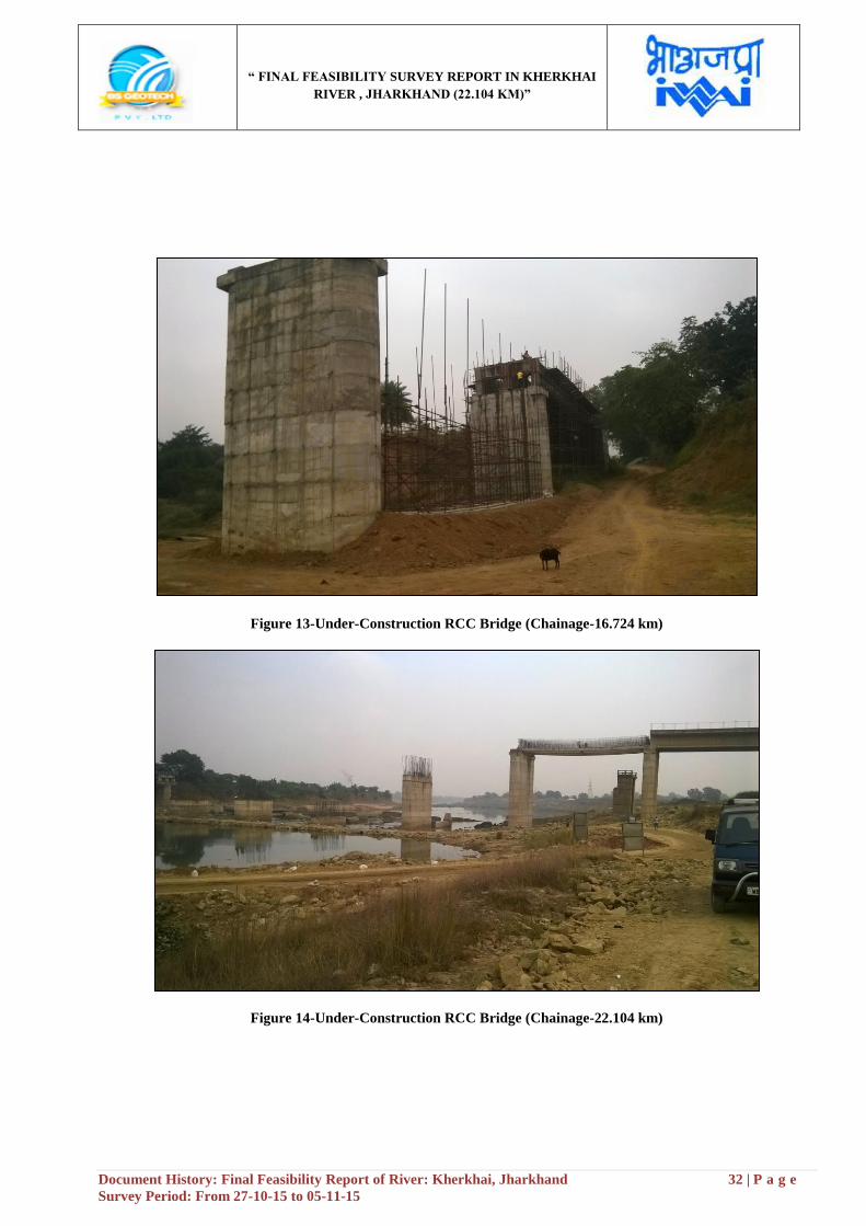
important check Dams are situated near the Chainage of 10.642 km at Kulaptanga village and 15.623 km at
Dudra village. The position of the Check Dams are (Lat: - 22°46'6.32"N, Long: - 86°10'20.04"E), (Lat: -
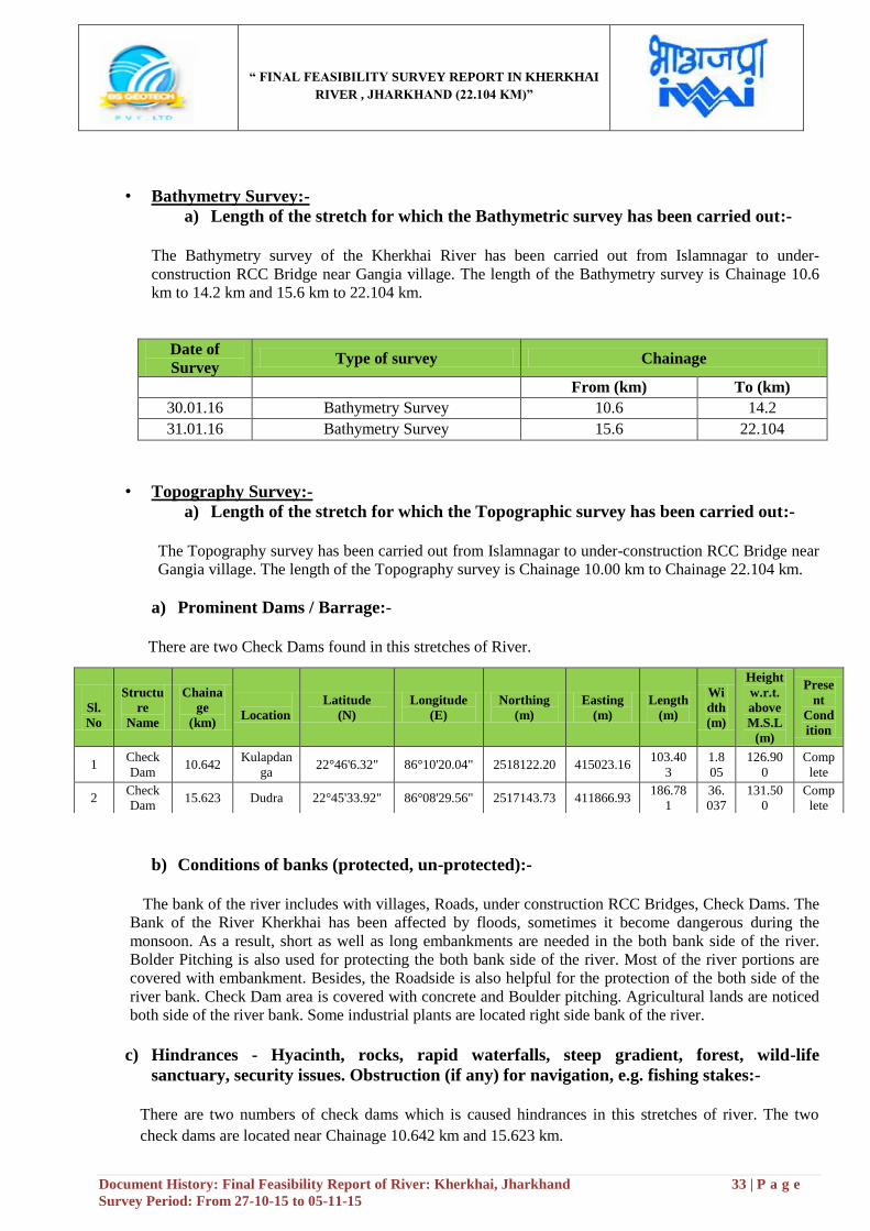
22°45'33.921"N, Long: - 86°08'29.568"E) respectively. Besides, two under-construction RCC Bridges are situated
near the Chainage of 16.724 km and 22.104 km at Itagarh village. The position of the under construction RCC
Bridges are (Lat: - 22°45'40.94"N, Long: - 86° 7'51.83"E), (Lat: - 22°45'6.67"N, Long: - 86° 5'9.64"E) respectively.
Marwari para, chowk bazaar, Jugsalai, Ambedkar Nagar, Bagbera Colony, Jatajhupri, Ranidih, Kacha, Itagarh,
Dhahkidah etc. villages are situated left bank side of the river and Dhowadungri, Assangi, Udaipur, Gangia etc.
villages are situated right bank side of the river.
Class
Chainage (km) Observed Reduced w.r.t. Sounding Datum
From To
Min.
dept
h (m)
Max.
dept
h (m)
Length
of Shoal
(m)
Dredging
Qty.
(cu.m.)
Min.
Dept
h (m)
Max.
Depth
(m)
Length
of Shoal
(m)
Dredging
Qty. (cu.m.)
I 10.00 22.104 0.3 7.5 8150 134787.4 -0.3 5.1 8080 155959
II 10.00 22.104 0.1 7.6 9250 227618.9 -0.3 5.2 10100 262375.5
III 10.00 22.104 0.1 7.6 11050 397948 -0.3 5.3 11000 469186.6
IV 10.00 22.104 0.1 7.6 12000 527414.4 -0.3 5.4 12000 611599.4
“ FINAL FEASIBILITY SURVEY REPORT IN KHERKHAI
RIVER , JHARKHAND (22.104 KM)”
Document History: Final Feasibility Report of River: Kherkhai, Jharkhand 31 | P a g e
Survey Period: From 27-10-15 to 05-11-15
Figure 11- Check Dam at Kalpatanga village (Chainage-10.642 km)
Figure 12-Check Dam at Dudra village (Chainage-15.623 km)
“ FINAL FEASIBILITY SURVEY REPORT IN KHERKHAI
RIVER , JHARKHAND (22.104 KM)”
Document History: Final Feasibility Report of River: Kherkhai, Jharkhand 32 | P a g e
Survey Period: From 27-10-15 to 05-11-15
Figure 13-Under-Construction RCC Bridge (Chainage-16.724 km)
Figure 14-Under-Construction RCC Bridge (Chainage-22.104 km)
“ FINAL FEASIBILITY SURVEY REPORT IN KHERKHAI
RIVER , JHARKHAND (22.104 KM)”
Document History: Final Feasibility Report of River: Kherkhai, Jharkhand 33 | P a g e
Survey Period: From 27-10-15 to 05-11-15
• Bathymetry Survey:-
a) Length of the stretch for which the Bathymetric survey has been carried out:-
The Bathymetry survey of the Kherkhai River has been carried out from Islamnagar to under-
construction RCC Bridge near Gangia village. The length of the Bathymetry survey is Chainage 10.6
km to 14.2 km and 15.6 km to 22.104 km.
Date of
Survey Type of survey Chainage
From (km) To (km)
30.01.16 Bathymetry Survey 10.6 14.2
31.01.16 Bathymetry Survey 15.6 22.104
• Topography Survey:-
a) Length of the stretch for which the Topographic survey has been carried out:-
The Topography survey has been carried out from Islamnagar to under-construction RCC Bridge near
Gangia village. The length of the Topography survey is Chainage 10.00 km to Chainage 22.104 km.
a) Prominent Dams / Barrage:-
There are two Check Dams found in this stretches of River.
b) Conditions of banks (protected, un-protected):-
The bank of the river includes with villages, Roads, under construction RCC Bridges, Check Dams. The
Bank of the River Kherkhai has been affected by floods, sometimes it become dangerous during the
monsoon. As a result, short as well as long embankments are needed in the both bank side of the river.
Bolder Pitching is also used for protecting the both bank side of the river. Most of the river portions are
covered with embankment. Besides, the Roadside is also helpful for the protection of the both side of the
river bank. Check Dam area is covered with concrete and Boulder pitching. Agricultural lands are noticed
both side of the river bank. Some industrial plants are located right side bank of the river.
c) Hindrances - Hyacinth, rocks, rapid waterfalls, steep gradient, forest, wild-life
sanctuary, security issues. Obstruction (if any) for navigation, e.g. fishing stakes:-
There are two numbers of check dams which is caused hindrances in this stretches of river. The two
check dams are located near Chainage 10.642 km and 15.623 km.
Chainage
Sl.
No
Structu
re
Name
Chaina
ge
(km)
Location
Latitude
(N)
Longitude
(E)
Northing
(m)
Easting
(m)
Length
(m)
Wi
dth
(m)
Height
w.r.t.
above
M.S.L
(m)
Prese
nt
Cond
ition
1 Check
Dam 10.642
Kulapdan
ga 22°46'6.32" 86°10'20.04" 2518122.20 415023.16
103.40
3
1.8
05
126.90
0
Comp
lete
2 Check
Dam 15.623 Dudra 22°45'33.92" 86°08'29.56" 2517143.73 411866.93
186.78
1
36.
037
131.50
0
Comp
lete

“ FINAL FEASIBILITY SURVEY REPORT IN KHERKHAI
RIVER , JHARKHAND (22.104 KM)”
Document History: Final Feasibility Report of River: Kherkhai, Jharkhand 34 | P a g e
Survey Period: From 27-10-15 to 05-11-15
d) Details of Protected Area- Wildlife, Defence, Atomic Power Plants and any other issue
attached to it:- There is no wildlife sanctuary found in this stretches of river.
e) NH/SH/MDR along and/or within 5 km from the waterways:-
There is no NH found in this stretches of river. SH-5(approx-3 km) and SH-6(approx-1.2 km) are
found in this stretches of river.
f) Railway Line and Stations in the vicinity:- There is no railway line found in this stretches of river.
g) Land Use Pattern along Waterway on visual assessment:- The most of the land portion in this stretches of river covered with agricultural lands. Besides, some
major and small kinds of industries are set up in this stretches of river.
h) Crops / Agriculture in the region on visual assessment:-
The major crops Paddy, jute, Tea, Rice, Wheat, Maize, Pulses, oilseeds and Spices are cultivated in this
region. Besides, fruits, vegetables, cashew nuts are also noticed in this zone of river.
i) Availability of Bulk / Construction Material:-
The availability of the construction materials is too easy for construction & any kind of structure. There
are many cementing factories and brick fields are located and the sand is also available from the river.
Burma Mines is located near the river side. Iron ore is an important material found in this zone of river.
j) Existing Industries along Waterway with their types and details:-
Burma Mines (Near Tatanagar Jn. Railway Station), Tata Motors, Tata Power Company and small kind
of plants and industries are located in this stretches of river.
k) Existing Ghats, Jetties and Terminals (with conditions and facilities). Existing navigation
facilities (if any):-
There is no Jetty service, ferry ghat and terminal available in this stretches of river.
l) Existing Cargo Movement:- The cargo movement is generally processed by waterways system like Ferry services. There is no ferry
services found in this zone of river. So the cargo movement is unavailable in this zone of river.
m) Prominent City / Town / Places of Worship / Historical places for Tourism:- Tatanagar, Chowk Bazar, Marwari para etc. places are located in this stretches of river.
“ FINAL FEASIBILITY SURVEY REPORT IN KHERKHAI
RIVER , JHARKHAND (22.104 KM)”
Document History: Final Feasibility Report of River: Kherkhai, Jharkhand 35 | P a g e
Survey Period: From 27-10-15 to 05-11-15
n) Village / colonies along the sub-stretch and approx. Population:- Bikrampur, Barodaghat colony, Kulaptanga, Jatajhupri, Transport Nagar, Kacha, Jilingbera,
Dhowadungri, Dudra, Itagarh, Dhahkidah, Udaipur, Gangia, Nayagarh etc. villages are located in this
stretches of river.
o) Availability of Passenger Ferry Services with facilities and Annual movement data:- There is no Passenger ferry service available in this stretches of river.
p) Available and probable Water Sport Recreational Facilities:-
There are no water sport recreational facilities available in this zone of river.
q) Fishing activities:-
Fish and fishing business in the river Subarnarekha and Kherkhai are an important sector in this region.
Cast nets, Scoop nets, Gill nets, Fishing lines, Tire tubes, make shift wooden platforms and Traditional
Bamboo Trap used for catching the fishes here. Fishing plays an important role in supporting livelihood
for the inhabitants of this Region. Fishes are one of the main occupations in this region of people where so
many people are engaged with this profession for the demand of fish.
r) Sand mining:-
The bank of the River Kherkhai is also used for the sand mines. The Sand Mining helps the people for
collection sand which is the major component for Building purposes. The Motor vehicles can easily collect
the sand and move for transportation. Sand Mines is an important sector where so many people are
engaged and these activities help them to get their daily livelihood. Besides this, sand is also exported to
other states as it becomes demandful for making Building or Industries.
s) Tributaries:- There is no tributary found in this stretches of river.
t) Details of Irrigation Canals and Outlets:- The Irrigation canals and outlets have been found near the Chainage of 12.1 km, 16 km in the left bank
side of the river and 10.720 km in the right bank side of the river.
u) Details of Nalas. Polluted water discharge in to the rivers and treatment plants (if any):- There are no Nalas found in this zone of river.
v) Usage of water (drinking, irrigation, industries, navigation etc.) Water quality:-
The water of the river is used for agriculture and industrial purposes. Tata Motors, Burma mines and
small kind of industries are located in this stretches of river. Most of the parts in this stretches of river
covered with agricultural lands. So the water of the river is used as irrigation purposes. With the help of
irrigation canal and outlets the cultivation is easily accessible in this stretches of river.
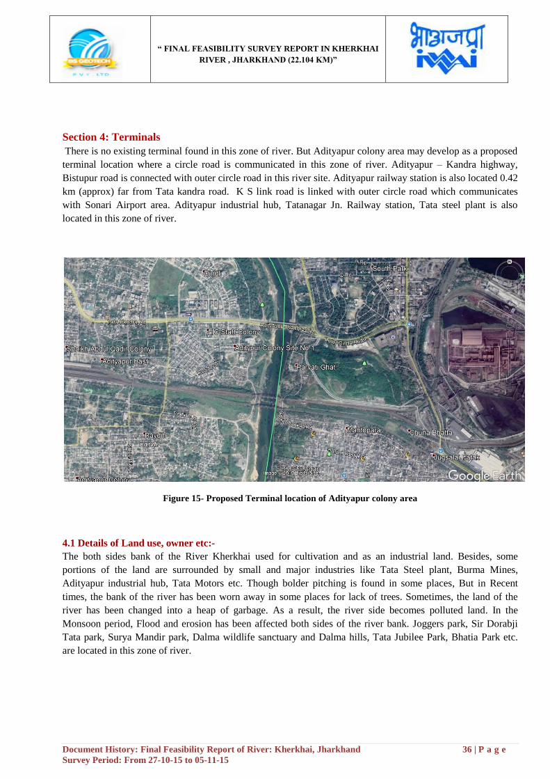
“ FINAL FEASIBILITY SURVEY REPORT IN KHERKHAI
RIVER , JHARKHAND (22.104 KM)”
Document History: Final Feasibility Report of River: Kherkhai, Jharkhand 36 | P a g e
Survey Period: From 27-10-15 to 05-11-15
Section 4: Terminals
There is no existing terminal found in this zone of river. But Adityapur colony area may develop as a proposed
terminal location where a circle road is communicated in this zone of river. Adityapur – Kandra highway,
Bistupur road is connected with outer circle road in this river site. Adityapur railway station is also located 0.42
km (approx) far from Tata kandra road. K S link road is linked with outer circle road which communicates
with Sonari Airport area. Adityapur industrial hub, Tatanagar Jn. Railway station, Tata steel plant is also
located in this zone of river.
Figure 15- Proposed Terminal location of Adityapur colony area
4.1 Details of Land use, owner etc:-
The both sides bank of the River Kherkhai used for cultivation and as an industrial land. Besides, some
portions of the land are surrounded by small and major industries like Tata Steel plant, Burma Mines,
Adityapur industrial hub, Tata Motors etc. Though bolder pitching is found in some places, But in Recent
times, the bank of the river has been worn away in some places for lack of trees. Sometimes, the land of the
river has been changed into a heap of garbage. As a result, the river side becomes polluted land. In the
Monsoon period, Flood and erosion has been affected both sides of the river bank. Joggers park, Sir Dorabji
Tata park, Surya Mandir park, Dalma wildlife sanctuary and Dalma hills, Tata Jubilee Park, Bhatia Park etc.
are located in this zone of river.

“ FINAL FEASIBILITY SURVEY REPORT IN KHERKHAI
RIVER , JHARKHAND (22.104 KM)”
Document History: Final Feasibility Report of River: Kherkhai, Jharkhand 37 | P a g e
Survey Period: From 27-10-15 to 05-11-15
Section 5: Fairway development:-
Dredging sections, summary of depths and dredging quantity for different classification of waterways
(stretch-wise)
Class-I:-
42 m Top width
30 m Bottom width
Class-I
Location Chainage (km) Observed Dredging Qty.w.r.t Sounding Datum Reduced Dredging Qty.w.r.t Sounding Datum
From To From To
Min
dept
h
(m)
Max
dept
h
(m)
Lengt
h of
Shoal
(m)
Dredging
Qty.
(cu.m.)
Cumulati
ve
Dredging
Qty.
(cu.m.)
Min
Dep
th
(m)
Max
Dep
th
(m)
Lengt
h of
Shoal
(m)
Dredging
Qty.
(cu.m.)
Cumulative
Dredging
Qty.
(cu.m.)
Conflue
nce of
Subarna
rekha
river
Adit
yapu
r
0.00 10.00 0.4 5.2 10000 367796.90 367796.90 -0.3 3.4 10000 862169.50 862169.50
Adityap
ur
Gan
gia 10.00
22.10
4 0.3 7.5 7800 134787.40 502584.30 -0.3 5.1 7390 155959.00 1018128.50
Total 17800 502584.30
Total 17390 1018128.50
Table 16- Dredging quantity in class-I
1:5 Slope 1.2 m Depth
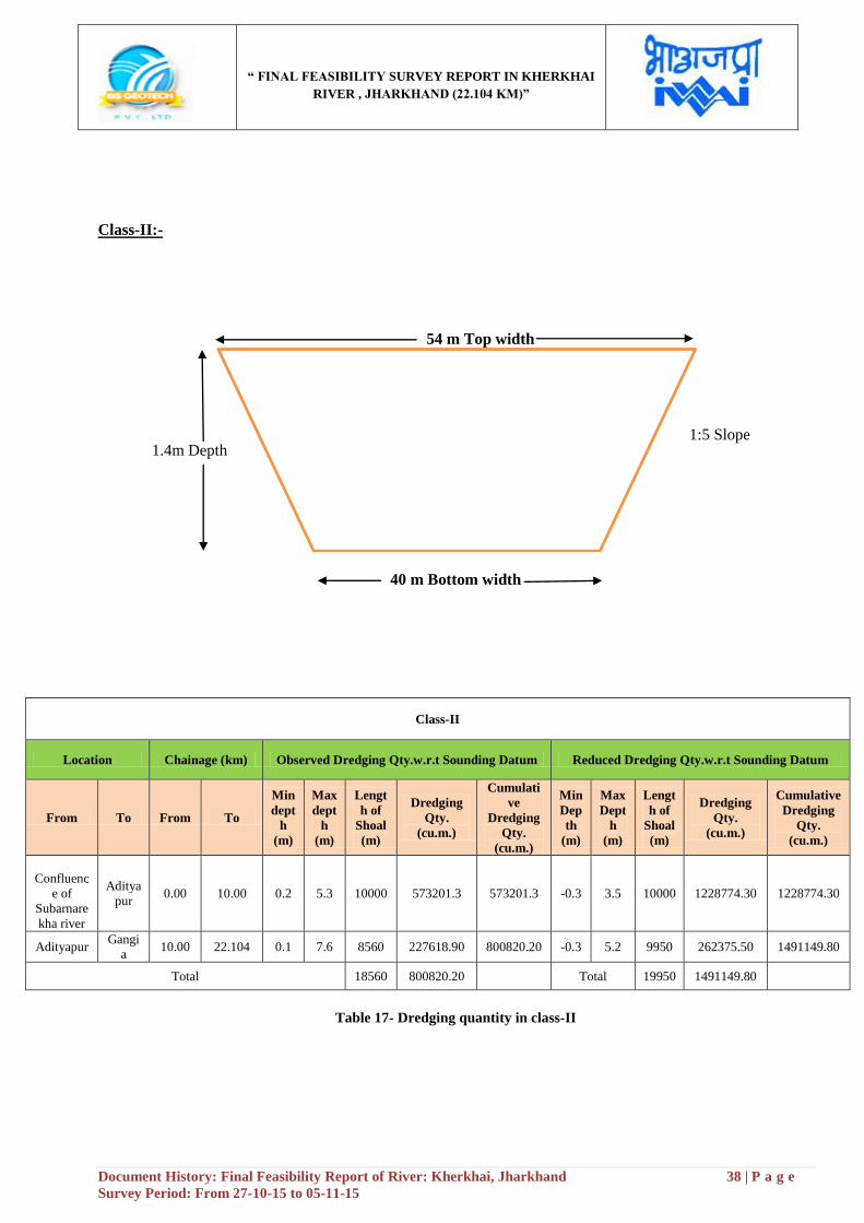
“ FINAL FEASIBILITY SURVEY REPORT IN KHERKHAI
RIVER , JHARKHAND (22.104 KM)”
Document History: Final Feasibility Report of River: Kherkhai, Jharkhand 38 | P a g e
Survey Period: From 27-10-15 to 05-11-15
Class-II:-
54 m Top width
40 m Bottom width
Class-II
Location Chainage (km) Observed Dredging Qty.w.r.t Sounding Datum Reduced Dredging Qty.w.r.t Sounding Datum
From To From To
Min
dept
h
(m)
Max
dept
h
(m)
Lengt
h of
Shoal
(m)
Dredging
Qty.
(cu.m.)
Cumulati
ve
Dredging
Qty.
(cu.m.)
Min
Dep
th
(m)
Max
Dept
h
(m)
Lengt
h of
Shoal
(m)
Dredging
Qty.
(cu.m.)
Cumulative
Dredging
Qty.
(cu.m.)
Confluenc
e of
Subarnare
kha river
Aditya
pur 0.00 10.00 0.2 5.3 10000 573201.3 573201.3 -0.3 3.5 10000 1228774.30 1228774.30
Adityapur Gangi
a 10.00 22.104 0.1 7.6 8560 227618.90 800820.20 -0.3 5.2 9950 262375.50 1491149.80
Total 18560 800820.20
Total 19950 1491149.80
Table 17- Dredging quantity in class-II
1:5 Slope 1.4m Depth
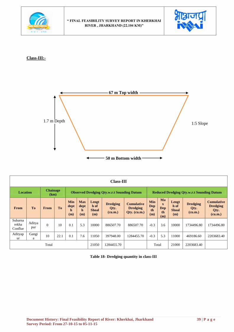
“ FINAL FEASIBILITY SURVEY REPORT IN KHERKHAI
RIVER , JHARKHAND (22.104 KM)”
Document History: Final Feasibility Report of River: Kherkhai, Jharkhand 39 | P a g e
Survey Period: From 27-10-15 to 05-11-15
Class-III:-
67 m Top width
50 m Bottom width
Class-III
Location Chainage
(km) Observed Dredging Qty.w.r.t Sounding Datum Reduced Dredging Qty.w.r.t Sounding Datum
From To From To
Min
dept
h
(m)
Max
dept
h
(m)
Lengt
h of
Shoal
(m)
Dredging
Qty.
(cu.m.)
Cumulative
Dredging
Qty. (cu.m.)
Min
Dep
th
(m)
Ma
x
Dep
th
(m)
Lengt
h of
Shoal
(m)
Dredging
Qty.
(cu.m.)
Cumulative
Dredging
Qty.
(cu.m.)
Subarna
rekha
Conflue
nce
Aditya
pur 0 10 0.1 5.3 10000 886507.70 886507.70 -0.3 3.6 10000 1734496.80 1734496.80
Adityap
ur
Gangi
a 10 22.1 0.1 7.6 11050 397948.00 1284455.70 -0.3 5.3 11000 469186.60 2203683.40
Total 21050 1284455.70
Total 21000 2203683.40
Table 18- Dredging quantity in class-III
1:5 Slope 1.7 m Depth

“ FINAL FEASIBILITY SURVEY REPORT IN KHERKHAI
RIVER , JHARKHAND (22.104 KM)”
Document History: Final Feasibility Report of River: Kherkhai, Jharkhand 40 | P a g e
Survey Period: From 27-10-15 to 05-11-15
Class-IV:-
70 m Top width
50 m Bottom width
Class-IV
Location Chainage
(km) Observed Dredging Qty.w.r.t Sounding Datum Reduced Dredging Qty.w.r.t Sounding Datum
From To Fro
m To
Min
depth
(m)
Max
dept
h
(m)
Lengt
h of
Shoal
(m)
Dredging
Qty.
(cu.m.)
Cumulative
Dredging
Qty.
(cu.m.)
Min
Dep
th
(m)
Max
Dep
th
(m)
Lengt
h of
Shoal
(m)
Dredging
Qty.
(cu.m.)
Cumulative
Dredging
Qty.
(cu.m.)
Subarna
rekha
Conflue
nce
Aditya
pur 0 10 0.1 5.3 10000 1083387.50 1083387.50 -0.3 3.7 10000 1979483.90 1979483.90
Adityap
ur
Gangi
a 10
22.1
04 0.1 7.6 12000 527414.40 1610801.90 -0.3 5.4 12000 611599.40 2591083.30
Total 22000 1610801.90
Total 22000 2591083.30
Table 19- Dredging quantity in class- IV
1:5 Slope 2.0m Depth

“ FINAL FEASIBILITY SURVEY REPORT IN KHERKHAI
RIVER , JHARKHAND (22.104 KM)”
Document History: Final Feasibility Report of River: Kherkhai, Jharkhand 41 | P a g e
Survey Period: From 27-10-15 to 05-11-15
Section 6: Conclusion
The Survey stretch of Kherkhai River is 22.104 km, major tributaries of the Subarnarekha River situated near at
Jamshedpur Site, Jharkhand. There is no Ferry service available in this zone of river. The waterway of the
Kherkhai River includes with many villages, Rail and Road etc. There are two Railway Bridges are crossing
over the river which is very communicative for the native villagers and the foreigners. The Railway line is
connected with Adityapur, Tatanagar Jn. Railway station. Three RCC bridges are situated in this zone of river
which is named Adityapur RCC Colony Bridge and RCC Toll Bridge which are also linked with Adityapur-
Kandra road. Tourists can have beautiful view of the river and its natural surroundings. Adityapur, Adarsh
Nagar, Jamshedpur etc. cities are situated in this zone of river. NH-32, NH-33 is the major communicative way
in this zone and other state-Highways like SH-5, SH-6 are situated for a better communication system and good
transportation.
Jamshedpur steel plants, Burma Mines, Tatanagar, Adityapur industrial hub are located near the river side.
Besides, small kinds of industries are also located near the Jamshedpur city. Sonari Airport is situated in this
zone of river. Dalma wildlife sanctuary, Jubilee Park, Sir Dorabji Tata Park, Hudco Lake, Bhuvneswari temple,
Kalibari temple, St.mary church, Dimna Lake, Dalma hills are the important tourist places located in this zone
of river. The Material like Iron ore is found near at Jamshedpur site.
6.1 Class wise Avg. Reduced Depths/Percentage:-
6.2 Range of Depths:-
Sl No
From
Chainage
(km)
To
Chainage
(km)
Reduced Depth
<1.2 m
(km)
1.2 m to 1.4 m
(km)
1.5 m to 1.7 m
(km)
1.8 m to 2.0 m
(km)
>2.0 m
(km)
1 0.00 10.00 6.6 0 0 0 3.4
2 10.00 22.104 0.7 1.2 1.7 1.9 6.6
Sl.
No
From
Chaina
ge
(km)
To
Chainage
(km)
Minimum Avg. Reduced Depth/Percentage Maximum Avg. Reduced Depth/percentage
Class-I Class-II Class-III Class-IV Class-I Class-II Class-III Class-
IV
1 0.00 10.00 -0.3/-0.003 -0.3/-0.003 -0.3/-0.003 -0.3/-0.003 0.62/0.00
62 0.714/0.0071
4 0.808/0.00808
0.902/0.00902
2 10.00 22.104 0.28/0.0028 0.08/0.0008 0.04/0.0004 -0.08/-0.0008 2.28/0.02
28 2.38/0.0238 2.49/0.0249
2.59/0.025
9
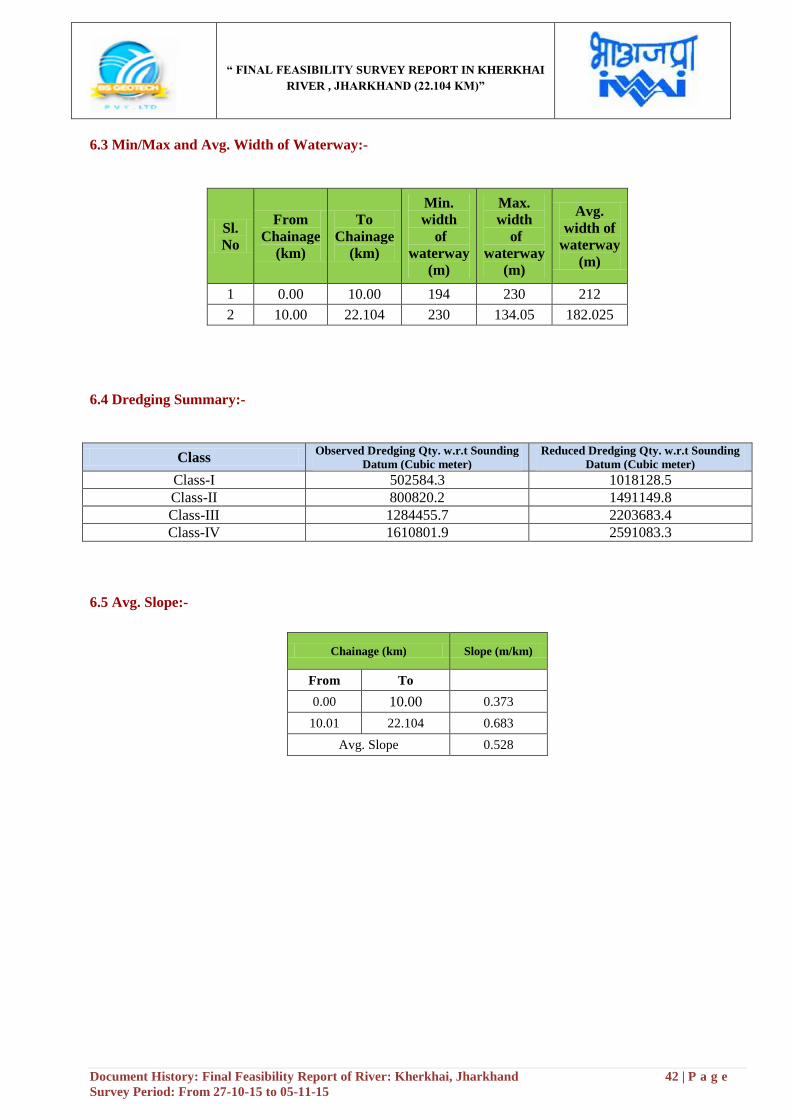
“ FINAL FEASIBILITY SURVEY REPORT IN KHERKHAI
RIVER , JHARKHAND (22.104 KM)”
Document History: Final Feasibility Report of River: Kherkhai, Jharkhand 42 | P a g e
Survey Period: From 27-10-15 to 05-11-15
6.3 Min/Max and Avg. Width of Waterway:-
Sl.
No
From
Chainage
(km)
To
Chainage
(km)
Min.
width
of
waterway
(m)
Max.
width
of
waterway
(m)
Avg.
width of
waterway
(m)
1 0.00 10.00 194 230 212
2 10.00 22.104 230 134.05 182.025
6.4 Dredging Summary:-
Class Observed Dredging Qty. w.r.t Sounding
Datum (Cubic meter)
Reduced Dredging Qty. w.r.t Sounding
Datum (Cubic meter)
Class-I 502584.3 1018128.5
Class-II 800820.2 1491149.8
Class-III 1284455.7 2203683.4
Class-IV 1610801.9 2591083.3
6.5 Avg. Slope:-
Chainage (km) Slope (m/km)
From To
0.00 10.00 0.373
10.01 22.104 0.683
Avg. Slope 0.528
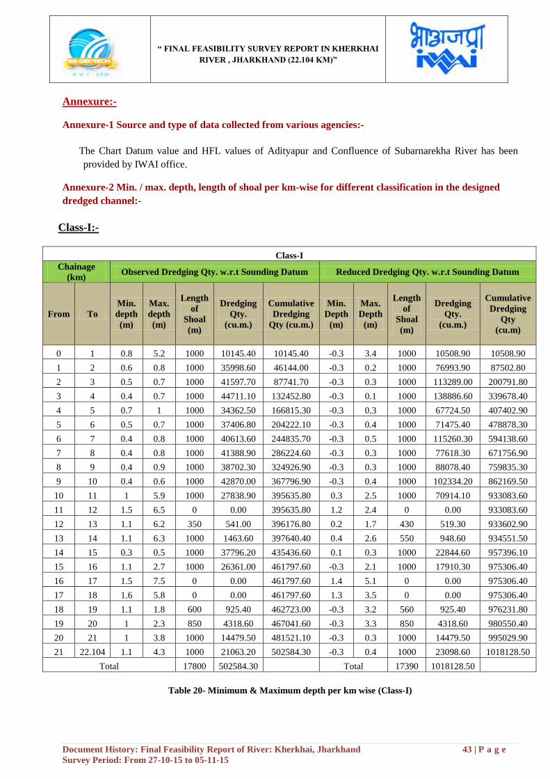
“ FINAL FEASIBILITY SURVEY REPORT IN KHERKHAI
RIVER , JHARKHAND (22.104 KM)”
Document History: Final Feasibility Report of River: Kherkhai, Jharkhand 43 | P a g e
Survey Period: From 27-10-15 to 05-11-15
Annexure:-
Annexure-1 Source and type of data collected from various agencies:-
The Chart Datum value and HFL values of Adityapur and Confluence of Subarnarekha River has been
provided by IWAI office.
Annexure-2 Min. / max. depth, length of shoal per km-wise for different classification in the designed
dredged channel:-
Class-I:-
Class-I
Chainage
(km) Observed Dredging Qty. w.r.t Sounding Datum Reduced Dredging Qty. w.r.t Sounding Datum
From To
Min.
depth
(m)
Max.
depth
(m)
Length
of
Shoal
(m)
Dredging
Qty.
(cu.m.)
Cumulative
Dredging
Qty (cu.m.)
Min.
Depth
(m)
Max.
Depth
(m)
Length
of
Shoal
(m)
Dredging
Qty.
(cu.m.)
Cumulative
Dredging
Qty
(cu.m)
0 1 0.8 5.2 1000 10145.40 10145.40 -0.3 3.4 1000 10508.90 10508.90
1 2 0.6 0.8 1000 35998.60 46144.00 -0.3 0.2 1000 76993.90 87502.80
2 3 0.5 0.7 1000 41597.70 87741.70 -0.3 0.3 1000 113289.00 200791.80
3 4 0.4 0.7 1000 44711.10 132452.80 -0.3 0.1 1000 138886.60 339678.40
4 5 0.7 1 1000 34362.50 166815.30 -0.3 0.3 1000 67724.50 407402.90
5 6 0.5 0.7 1000 37406.80 204222.10 -0.3 0.4 1000 71475.40 478878.30
6 7 0.4 0.8 1000 40613.60 244835.70 -0.3 0.5 1000 115260.30 594138.60
7 8 0.4 0.8 1000 41388.90 286224.60 -0.3 0.3 1000 77618.30 671756.90
8 9 0.4 0.9 1000 38702.30 324926.90 -0.3 0.3 1000 88078.40 759835.30
9 10 0.4 0.6 1000 42870.00 367796.90 -0.3 0.4 1000 102334.20 862169.50
10 11 1 5.9 1000 27838.90 395635.80 0.3 2.5 1000 70914.10 933083.60
11 12 1.5 6.5 0 0.00 395635.80 1.2 2.4 0 0.00 933083.60
12 13 1.1 6.2 350 541.00 396176.80 0.2 1.7 430 519.30 933602.90
13 14 1.1 6.3 1000 1463.60 397640.40 0.4 2.6 550 948.60 934551.50
14 15 0.3 0.5 1000 37796.20 435436.60 0.1 0.3 1000 22844.60 957396.10
15 16 1.1 2.7 1000 26361.00 461797.60 -0.3 2.1 1000 17910.30 975306.40
16 17 1.5 7.5 0 0.00 461797.60 1.4 5.1 0 0.00 975306.40
17 18 1.6 5.8 0 0.00 461797.60 1.3 3.5 0 0.00 975306.40
18 19 1.1 1.8 600 925.40 462723.00 -0.3 3.2 560 925.40 976231.80
19 20 1 2.3 850 4318.60 467041.60 -0.3 3.3 850 4318.60 980550.40
20 21 1 3.8 1000 14479.50 481521.10 -0.3 0.3 1000 14479.50 995029.90
21 22.104 1.1 4.3 1000 21063.20 502584.30 -0.3 0.4 1000 23098.60 1018128.50
Total 17800 502584.30 Total 17390 1018128.50
Table 20- Minimum & Maximum depth per km wise (Class-I)
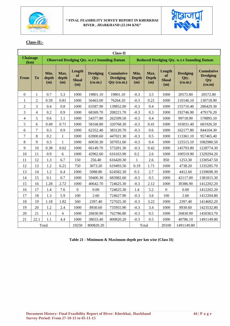
“ FINAL FEASIBILITY SURVEY REPORT IN KHERKHAI
RIVER , JHARKHAND (22.104 KM)”
Document History: Final Feasibility Report of River: Kherkhai, Jharkhand 44 | P a g e
Survey Period: From 27-10-15 to 05-11-15
Class-II:-
Class-II
Chainage
(km) Observed Dredging Qty. w.r.t Sounding Datum Reduced Dredging Qty. w.r.t Sounding Datum
From To
Min.
depth
(m)
Max.
depth
(m)
Length
of
Shoal
(m)
Dredging
Qty.
(cu.m.)
Cumulative
Dredging
Qty (cu.m.)
Min.
Depth
(m)
Max.
Depth
(m)
Length
of
Shoal
(m)
Dredging
Qty.
(cu.m.)
Cumulative
Dredging
Qty
(cu.m)
0 1 0.7 5.3 1000 19801.10 19801.10 -0.3 3.5 1000 20572.80 20572.80
1 2 0.59 0.81 1000 56463.00 76264.10 -0.3 0.21 1000 110146.10 130718.90
2 3 0.4 0.8 1000 63587.90 139852.00 -0.3 0.4 1000 155710.40 286429.30
3 4 0.2 0.9 1000 68369.70 208221.70 -0.3 0.3 1000 192746.90 479176.20
4 5 0.6 1.1 1000 54377.80 262599.50 -0.3 0.4 1000 99718.90 578895.10
5 6 0.49 0.71 1000 58168.80 320768.30 -0.3 0.41 1000 103031.40 681926.50
6 7 0.3 0.9 1000 62352.40 383120.70 -0.3 0.6 1000 162177.80 844104.30
7 8 0.2 1 1000 63900.60 447021.30 -0.3 0.5 1000 113361.10 957465.40
8 9 0.3 1 1000 60030.30 507051.60 -0.3 0.4 1000 125515.10 1082980.50
9 10 0.38 0.62 1000 66149.70 573201.30 -0.3 0.42 1000 145793.80 1228774.30
10 11 0.9 6 1000 42962.60 616163.90 0.2 2.6 1000 100519.90 1329294.20
11 12 1.3 6.7 150 256.40 616420.30 1 2.6 850 1253.30 1330547.50
12 13 1.2 6.21 750 3073.20 619493.50 0.19 1.71 1000 4738.20 1335285.70
13 14 1.2 6.4 1000 5088.80 624582.30 0.3 2.7 1000 4412.60 1339698.30
14 15 0.1 0.7 1000 59400.30 683982.60 -0.3 0.5 1000 42117.00 1381815.30
15 16 1.28 2.72 1000 40642.70 724625.30 -0.3 2.12 1000 30386.90 1412202.20
16 17 1.4 7.6 0 0.00 724625.30 1.4 5.2 0 0.00 1412202.20
17 18 1.3 5.9 100 2.60 724627.90 -0.3 3.6 100 2.60 1412204.80
18 19 1.18 1.82 560 2397.40 727025.30 -0.3 3.22 1000 2397.40 1414602.20
19 20 1.2 2.4 1000 8930.60 735955.90 -0.3 3.4 1000 8930.60 1423532.80
20 21 1.1 4 1000 26830.90 762786.80 -0.3 0.5 1000 26830.90 1450363.70
21 22.1 1.1 4.4 1000 38033.40 800820.20 -0.3 0.5 1000 40786.10 1491149.80
Total 19250 800820.20 Total 20100 1491149.80
Table 21 - Minimum & Maximum depth per km wise (Class II)
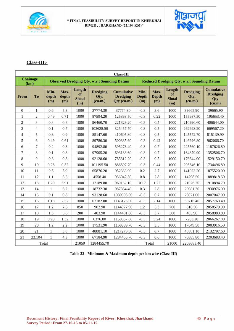
“ FINAL FEASIBILITY SURVEY REPORT IN KHERKHAI
RIVER , JHARKHAND (22.104 KM)”
Document History: Final Feasibility Report of River: Kherkhai, Jharkhand 45 | P a g e
Survey Period: From 27-10-15 to 05-11-15
Class-III:-
Class-III
Chainage
(km) Observed Dredging Qty. w.r.t Sounding Datum Reduced Dredging Qty. w.r.t Sounding Datum
From To
Min.
depth
(m)
Max.
depth
(m)
Length
of
Shoal
(m)
Dredging
Qty.
(cu.m.)
Cumulative
Dredging
Qty (cu.m.)
Min.
Depth
(m)
Max.
Depth
(m)
Length
of
Shoal
(m)
Dredging
Qty.
(cu.m.)
Cumulative
Dredging
Qty
(cu.m)
0 1 0.6 5.3 1000 37774.30 37774.30 -0.3 3.6 1000 39665.90 39665.90
1 2 0.49 0.71 1000 87594.20 125368.50 -0.3 0.22 1000 155987.50 195653.40
2 3 0.3 0.8 1000 96460.70 221829.20 -0.3 0.5 1000 210990.60 406644.00
3 4 0.1 0.7 1000 103628.50 325457.70 -0.3 0.5 1000 262923.20 669567.20
4 5 0.6 0.9 1000 85147.60 410605.30 -0.3 0.5 1000 145572.70 815139.90
5 6 0.49 0.61 1000 89780.30 500385.60 -0.3 0.42 1000 146926.80 962066.70
6 7 0.2 0.8 1000 94892.80 595278.40 -0.3 0.7 1000 225560.10 1187626.80
7 8 0.1 0.8 1000 97905.20 693183.60 -0.3 0.7 1000 164879.90 1352506.70
8 9 0.3 0.8 1000 92128.60 785312.20 -0.3 0.5 1000 176644.00 1529150.70
9 10 0.28 0.52 1000 101195.50 886507.70 -0.3 0.44 1000 205346.10 1734496.80
10 11 0.5 5.9 1000 65876.20 952383.90 0.2 2.7 1000 141023.20 1875520.00
11 12 1.1 6.5 1000 4558.40 956942.30 0.8 2.8 1000 14298.50 1889818.50
12 13 1.29 5.91 1000 12189.80 969132.10 0.17 1.72 1000 21076.20 1910894.70
13 14 1 6.2 1000 18732.30 987864.40 0.3 2.8 1000 20081.30 1930976.00
14 15 0.1 0.8 1000 93128.60 1080993.00 -0.3 0.7 1000 76071.00 2007047.00
15 16 1.18 2.52 1000 62182.00 1143175.00 -0.3 2.14 1000 50716.40 2057763.40
16 17 1.2 7.6 850 902.90 1144077.90 1.2 5.3 700 816.50 2058579.90
17 18 1.3 5.6 200 403.90 1144481.80 -0.3 3.7 300 403.90 2058983.80
18 19 0.98 1.32 1000 6376.00 1150857.80 -0.3 3.24 1000 7283.20 2066267.00
19 20 1.2 2.2 1000 17531.90 1168389.70 -0.3 3.5 1000 17649.50 2083916.50
20 21 1 3.8 1000 48881.10 1217270.80 -0.3 0.7 1000 48881.10 2132797.60
21 22.104 1 4.3 1000 67184.90 1284455.70 -0.3 0.6 1000 70885.80 2203683.40
Total 21050 1284455.70 Total 21000 2203683.40
Table 22 - Minimum & Maximum depth per km wise (Class III)
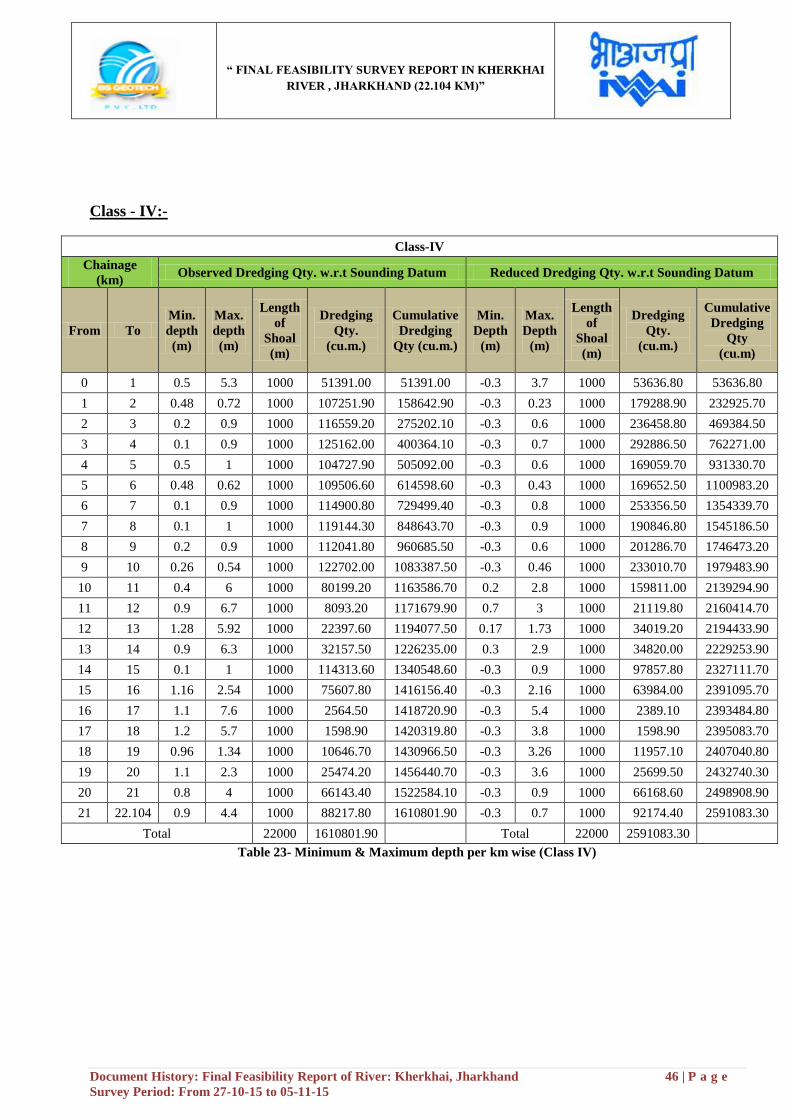
“ FINAL FEASIBILITY SURVEY REPORT IN KHERKHAI
RIVER , JHARKHAND (22.104 KM)”
Document History: Final Feasibility Report of River: Kherkhai, Jharkhand 46 | P a g e
Survey Period: From 27-10-15 to 05-11-15
Class - IV:-
Class-IV
Chainage
(km) Observed Dredging Qty. w.r.t Sounding Datum Reduced Dredging Qty. w.r.t Sounding Datum
From To
Min.
depth
(m)
Max.
depth
(m)
Length
of
Shoal
(m)
Dredging
Qty.
(cu.m.)
Cumulative
Dredging
Qty (cu.m.)
Min.
Depth
(m)
Max.
Depth
(m)
Length
of
Shoal
(m)
Dredging
Qty.
(cu.m.)
Cumulative
Dredging
Qty
(cu.m)
0 1 0.5 5.3 1000 51391.00 51391.00 -0.3 3.7 1000 53636.80 53636.80
1 2 0.48 0.72 1000 107251.90 158642.90 -0.3 0.23 1000 179288.90 232925.70
2 3 0.2 0.9 1000 116559.20 275202.10 -0.3 0.6 1000 236458.80 469384.50
3 4 0.1 0.9 1000 125162.00 400364.10 -0.3 0.7 1000 292886.50 762271.00
4 5 0.5 1 1000 104727.90 505092.00 -0.3 0.6 1000 169059.70 931330.70
5 6 0.48 0.62 1000 109506.60 614598.60 -0.3 0.43 1000 169652.50 1100983.20
6 7 0.1 0.9 1000 114900.80 729499.40 -0.3 0.8 1000 253356.50 1354339.70
7 8 0.1 1 1000 119144.30 848643.70 -0.3 0.9 1000 190846.80 1545186.50
8 9 0.2 0.9 1000 112041.80 960685.50 -0.3 0.6 1000 201286.70 1746473.20
9 10 0.26 0.54 1000 122702.00 1083387.50 -0.3 0.46 1000 233010.70 1979483.90
10 11 0.4 6 1000 80199.20 1163586.70 0.2 2.8 1000 159811.00 2139294.90
11 12 0.9 6.7 1000 8093.20 1171679.90 0.7 3 1000 21119.80 2160414.70
12 13 1.28 5.92 1000 22397.60 1194077.50 0.17 1.73 1000 34019.20 2194433.90
13 14 0.9 6.3 1000 32157.50 1226235.00 0.3 2.9 1000 34820.00 2229253.90
14 15 0.1 1 1000 114313.60 1340548.60 -0.3 0.9 1000 97857.80 2327111.70
15 16 1.16 2.54 1000 75607.80 1416156.40 -0.3 2.16 1000 63984.00 2391095.70
16 17 1.1 7.6 1000 2564.50 1418720.90 -0.3 5.4 1000 2389.10 2393484.80
17 18 1.2 5.7 1000 1598.90 1420319.80 -0.3 3.8 1000 1598.90 2395083.70
18 19 0.96 1.34 1000 10646.70 1430966.50 -0.3 3.26 1000 11957.10 2407040.80
19 20 1.1 2.3 1000 25474.20 1456440.70 -0.3 3.6 1000 25699.50 2432740.30
20 21 0.8 4 1000 66143.40 1522584.10 -0.3 0.9 1000 66168.60 2498908.90
21 22.104 0.9 4.4 1000 88217.80 1610801.90 -0.3 0.7 1000 92174.40 2591083.30
Total 22000 1610801.90
Total 22000 2591083.30
Table 23- Minimum & Maximum depth per km wise (Class IV)
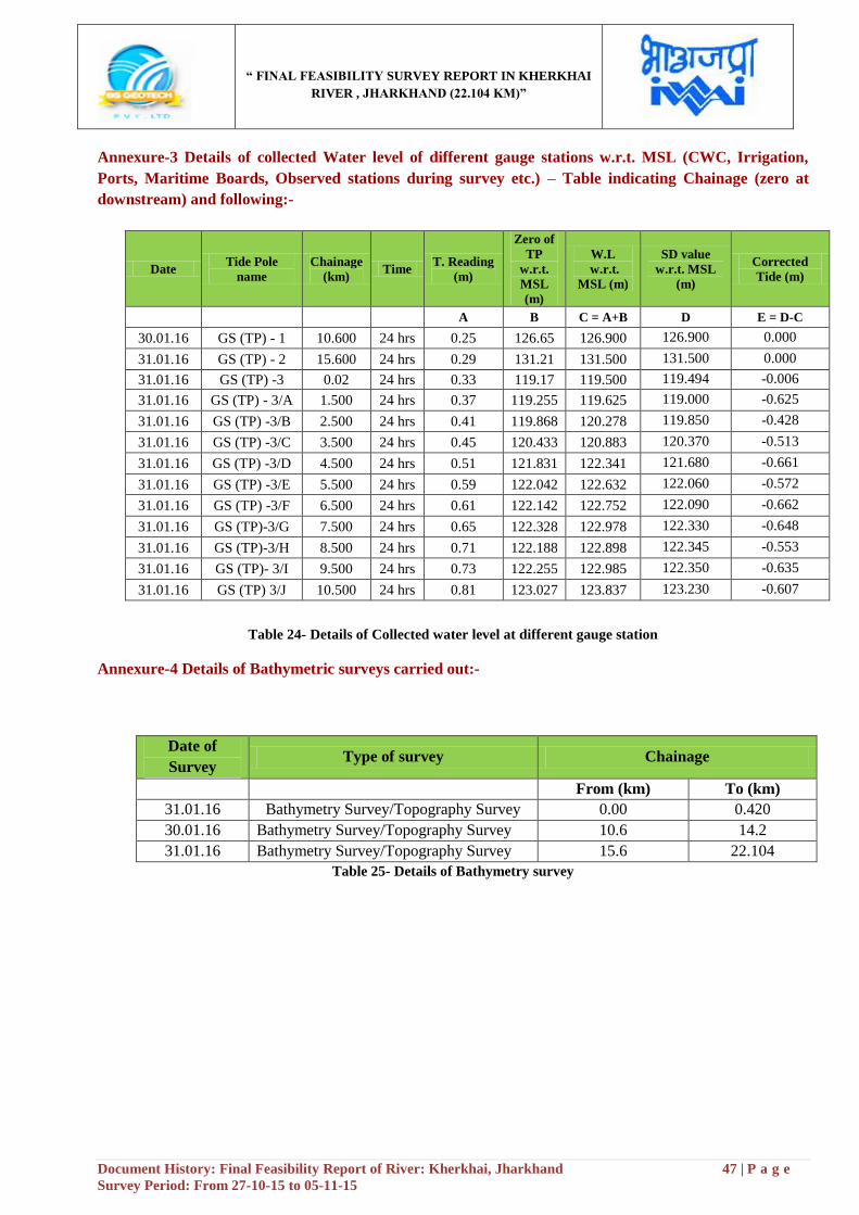
“ FINAL FEASIBILITY SURVEY REPORT IN KHERKHAI
RIVER , JHARKHAND (22.104 KM)”
Document History: Final Feasibility Report of River: Kherkhai, Jharkhand 47 | P a g e
Survey Period: From 27-10-15 to 05-11-15
Annexure-3 Details of collected Water level of different gauge stations w.r.t. MSL (CWC, Irrigation,
Ports, Maritime Boards, Observed stations during survey etc.) – Table indicating Chainage (zero at
downstream) and following:-
Date Tide Pole
name
Chainage
(km) Time
T. Reading
(m)
Zero of
TP
w.r.t.
MSL
(m)
W.L
w.r.t.
MSL (m)
SD value
w.r.t. MSL
(m)
Corrected
Tide (m)
A B C = A+B D E = D-C
30.01.16 GS (TP) - 1 10.600 24 hrs 0.25 126.65 126.900 126.900 0.000
31.01.16 GS (TP) - 2 15.600 24 hrs 0.29 131.21 131.500 131.500 0.000
31.01.16 GS (TP) -3 0.02 24 hrs 0.33 119.17 119.500 119.494 -0.006
31.01.16 GS (TP) - 3/A 1.500 24 hrs 0.37 119.255 119.625 119.000 -0.625
31.01.16 GS (TP) -3/B 2.500 24 hrs 0.41 119.868 120.278 119.850 -0.428
31.01.16 GS (TP) -3/C 3.500 24 hrs 0.45 120.433 120.883 120.370 -0.513
31.01.16 GS (TP) -3/D 4.500 24 hrs 0.51 121.831 122.341 121.680 -0.661
31.01.16 GS (TP) -3/E 5.500 24 hrs 0.59 122.042 122.632 122.060 -0.572
31.01.16 GS (TP) -3/F 6.500 24 hrs 0.61 122.142 122.752 122.090 -0.662
31.01.16 GS (TP)-3/G 7.500 24 hrs 0.65 122.328 122.978 122.330 -0.648
31.01.16 GS (TP)-3/H 8.500 24 hrs 0.71 122.188 122.898 122.345 -0.553
31.01.16 GS (TP)- 3/I 9.500 24 hrs 0.73 122.255 122.985 122.350 -0.635
31.01.16 GS (TP) 3/J 10.500 24 hrs 0.81 123.027 123.837 123.230 -0.607
Table 24- Details of Collected water level at different gauge station
Annexure-4 Details of Bathymetric surveys carried out:-
Date of
Survey Type of survey Chainage
From (km) To (km)
31.01.16 Bathymetry Survey/Topography Survey 0.00 0.420
30.01.16 Bathymetry Survey/Topography Survey 10.6 14.2
31.01.16 Bathymetry Survey/Topography Survey 15.6 22.104
Table 25- Details of Bathymetry survey
“ FINAL FEASIBILITY SURVEY REPORT IN KHERKHAI
RIVER , JHARKHAND (22.104 KM)”
Document History: Final Feasibility Report of River: Kherkhai, Jharkhand 48 | P a g e
Survey Period: From 27-10-15 to 05-11-15
Annexure-5 Bank Protection along the Bank:-
The Bank of the river is well protected by both side embankment and also Boulder pitching. RCC Bridges,
Rail Bridges, Check Dams, H.T. Lines area are well protected by concrete pitching. During the monsoon, the
level of water becomes high and as a result the Basti area used to flood every year. Baba Tilka Majhi basti,
Gandhi Basti, Roop Nagar Basti area are often flooded in the monsoon. Boulder Pitching is not only
protecting the flood but it also can control the water pollution in recent times. From Chainage 0.00 km to 3.00
km, 5 km and 6 km Boulder pitching has been found left bank side of the river. Beside this, Tata Zoological
Park, Dalma wildlife Sanctuary and Dalma Hills, Jubilee Park are located near the bank side of this river
which are protected the bank side.
Annexure-6 Details of Features across the Bank:-
The bank of the river includes villages, Ferry ghat, Irrigation canals and outlets, Rail Bridges, RCC Bridges
and Forest etc. The both side river bank are highly protected by embankment and bolder pitching due to
flood, erosion etc. The villagers are also situated near the bank side of the river. Recently different kinds of
industries are also located near the bank side of the river. Adityapur Toll Bridge, Adityapur Colony RCC
Bridges, Adityapur colony Rail Bridges, Check Dams, Electric Lines, H.T.Lines are located in this region of
river. Jamshedpur, a major industrial hub is located in this region of river. Tata steel plant, Burma Mines
etc. Industries are located in this region of river. Adityapur Railway station and Tatanagar Railway station
are located in this zone of river. Sonari airport, Dalma wildlife sanctuary and Dalma hills, Tata Zoological
Park, Bhatia Park, Hudco Lake, Dimna Lake etc. tourist places are located in this zone of river. Adarsh
Nagar, Adityapur, Jamshedpur, Tatanagar like cities are located in this region. Some Basti area like Baba
Tilka Majhi Basti, Roop Nagar Basti is located in this zone. Kalibari temple, Parsee Fire temple,
Bhuvneswari temple, Sai Baba temple, Rankini Mandir, St. Mary church are the places of worship located
in this region of river.
“ FINAL FEASIBILITY SURVEY REPORT IN KHERKHAI
RIVER , JHARKHAND (22.104 KM)”
Document History: Final Feasibility Report of River: Kherkhai, Jharkhand 49 | P a g e
Survey Period: From 27-10-15 to 05-11-15
Annexure-7 Detailed methodology adopted for carrying out survey. Horizontal Control and Vertical
Details Control:-
The Horizontal control for Topography survey: - High precision RTK DGPS in fix mode is using UHF
Radio Modem with IHO accuracy standards, with minimum 24 hours observations at some permanent
platform/base. The survey was undertaken as per the line plan provided and the spot level points in the cross
line were spaced at 40 m interval. The plotting of the chart was done on UTM Projection at Zone 45 N /WGS-
84 Datum as directed in the contract specifications. Topographic survey Equipments like South (S86T) GNSS
RTK, Total Station was used for conducting the Topography survey.
The Horizontal control for Bathymetry survey: - DGPS is receiving corrections from Beacons by the Bar
check Procedure method. The sound velocity was set to 1475 m/s on single beam echo sounder during
acquisition. The Daily bar checks were done prior to the sounding operation and before the closing of the
sounding operation for the day. Being very shallow depths, the echo sounder depths were also cross-checked in
between by using demarcated sounding poles during the conduct of the survey. The sounding lines were run
using Survey boat to identify the design line of the Kherkhai River for the possible stretch. The cross lines were
run perpendicular to the orientation of river flow (i.e. perpendicular to the orientation of depth contours) in
respective stretches. The spot sounding was also carried out in the area where the survey boat cannot be
operated due to low depth. The hemisphere DGPS and Sounding Pole were used for Spot sounding at shallow
locations in the Kherkhai River. The DGPS position along with water depths was recorded simultaneously and
the tidal reduction was applied to the obtained depths.
o Establishment of Vertical Control:-
Vertical control from C.W.C Gauge is used for the entire survey work. Its value is 123.00 meter w.r.t. M.S.L
has been considered for calculating the vertical levels. Total 3 no. Bench Mark was established along the
22.104 km of Kherkhai River with the reference of C.W.C Gauge which is situated near Adityapur Colony
area.
.
Topography Survey:-
The survey was commenced on 27th October
, 2015 and completed on 05th November, 2015. Then the days were
autumn season and arrival of winter season. The climate become normal which reached about 20◦ C. Mostly
day weather was sunny and was very favorable for the conduct of survey and the weather condition remains
same for the entire duration of the survey. The length of the Topography survey is from Chainage 0.00 km to
Chainage 22.104 km.
The survey was undertaken as per the line plan provided and the spot level points in the cross line were spaced
at 40 m interval. The plotting of the chart was done on UTM Projection at Zone 45 N as directed in the contract
specifications. The spot levels along the river were obtained by using Trimble DGPS. The data was post
processed using Trimble Business Center to get the precise position and MSL height values of the rover
locations. The topographic survey for the entire survey stretch was conducted to collect the following data:-
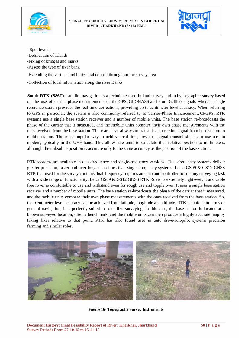
“ FINAL FEASIBILITY SURVEY REPORT IN KHERKHAI
RIVER , JHARKHAND (22.104 KM)”
Document History: Final Feasibility Report of River: Kherkhai, Jharkhand 50 | P a g e
Survey Period: From 27-10-15 to 05-11-15
- Spot levels
-Delineation of Islands
-Fixing of bridges and marks
-Assess the type of river bank
-Extending the vertical and horizontal control throughout the survey area
-Collection of local information along the river Banks
South RTK (S86T) satellite navigation is a technique used in land survey and in hydrographic survey based
on the use of carrier phase measurements of the GPS, GLONASS and / or Galileo signals where a single
reference station provides the real-time corrections, providing up to centimeter-level accuracy. When referring
to GPS in particular, the system is also commonly referred to as Carrier-Phase Enhancement, CPGPS. RTK
systems use a single base station receiver and a number of mobile units. The base station re-broadcasts the
phase of the carrier that it measured, and the mobile units compare their own phase measurements with the
ones received from the base station. There are several ways to transmit a correction signal from base station to
mobile station. The most popular way to achieve real-time, low-cost signal transmission is to use a radio
modem, typically in the UHF band. This allows the units to calculate their relative position to millimeters,
although their absolute position is accurate only to the same accuracy as the position of the base station.
RTK systems are available in dual-frequency and single-frequency versions. Dual-frequency systems deliver
greater precision, faster and over longer baselines than single-frequency systems. Leica GS09 & GS12 GNSS
RTK that used for the survey contains dual-frequency requires antenna and controller to suit any surveying task
with a wide range of functionality. Leica GS09 & GS12 GNSS RTK Rover is extremely light-weight and cable
free rover is comfortable to use and withstand even for rough use and topple over. It uses a single base station
receiver and a number of mobile units. The base station re-broadcasts the phase of the carrier that it measured,
and the mobile units compare their own phase measurements with the ones received from the base station. So,
that centimeter level accuracy can be achieved from latitude, longitude and altitude. RTK technique in terms of
general navigation, it is perfectly suited to roles like surveying. In this case, the base station is located at a
known surveyed location, often a benchmark, and the mobile units can then produce a highly accurate map by
taking fixes relative to that point. RTK has also found uses in auto drive/autopilot systems, precision
farming and similar roles.
Figure 16- Topography Survey Instruments
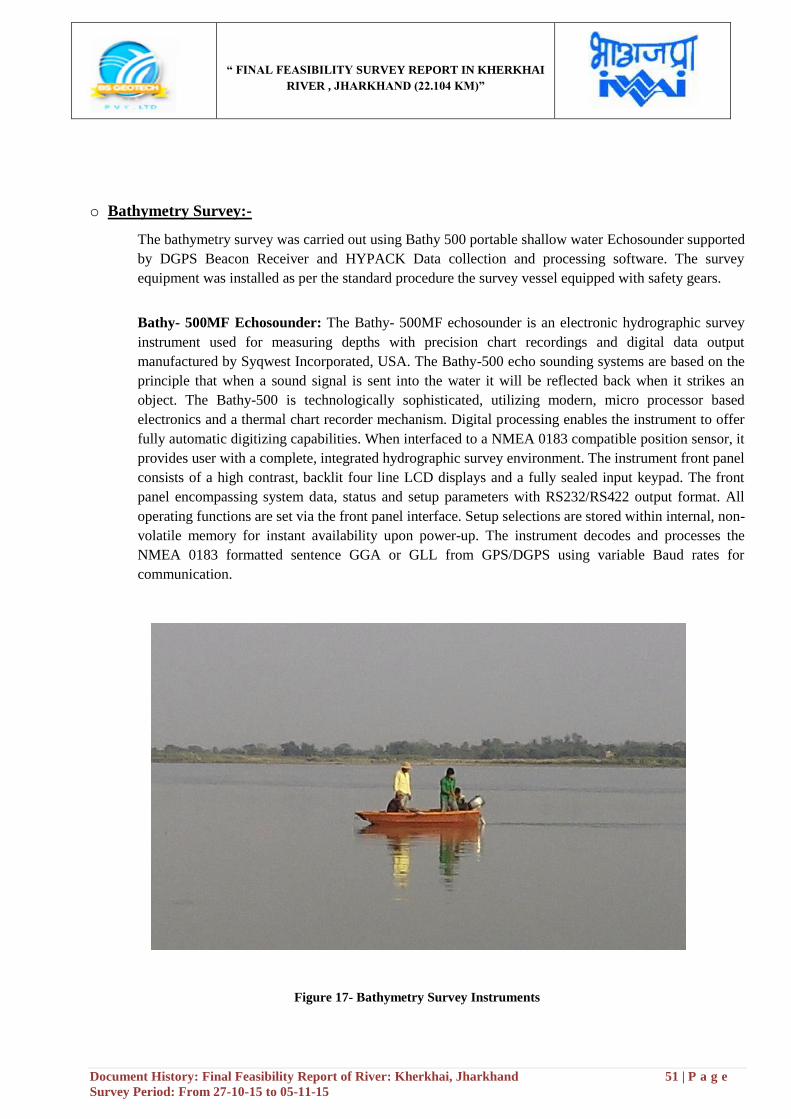
“ FINAL FEASIBILITY SURVEY REPORT IN KHERKHAI
RIVER , JHARKHAND (22.104 KM)”
Document History: Final Feasibility Report of River: Kherkhai, Jharkhand 51 | P a g e
Survey Period: From 27-10-15 to 05-11-15
o Bathymetry Survey:-
The bathymetry survey was carried out using Bathy 500 portable shallow water Echosounder supported
by DGPS Beacon Receiver and HYPACK Data collection and processing software. The survey
equipment was installed as per the standard procedure the survey vessel equipped with safety gears.
Bathy- 500MF Echosounder: The Bathy- 500MF echosounder is an electronic hydrographic survey
instrument used for measuring depths with precision chart recordings and digital data output
manufactured by Syqwest Incorporated, USA. The Bathy-500 echo sounding systems are based on the
principle that when a sound signal is sent into the water it will be reflected back when it strikes an
object. The Bathy-500 is technologically sophisticated, utilizing modern, micro processor based
electronics and a thermal chart recorder mechanism. Digital processing enables the instrument to offer
fully automatic digitizing capabilities. When interfaced to a NMEA 0183 compatible position sensor, it
provides user with a complete, integrated hydrographic survey environment. The instrument front panel
consists of a high contrast, backlit four line LCD displays and a fully sealed input keypad. The front
panel encompassing system data, status and setup parameters with RS232/RS422 output format. All
operating functions are set via the front panel interface. Setup selections are stored within internal, non-
volatile memory for instant availability upon power-up. The instrument decodes and processes the
NMEA 0183 formatted sentence GGA or GLL from GPS/DGPS using variable Baud rates for
communication.
Figure 17- Bathymetry Survey Instruments
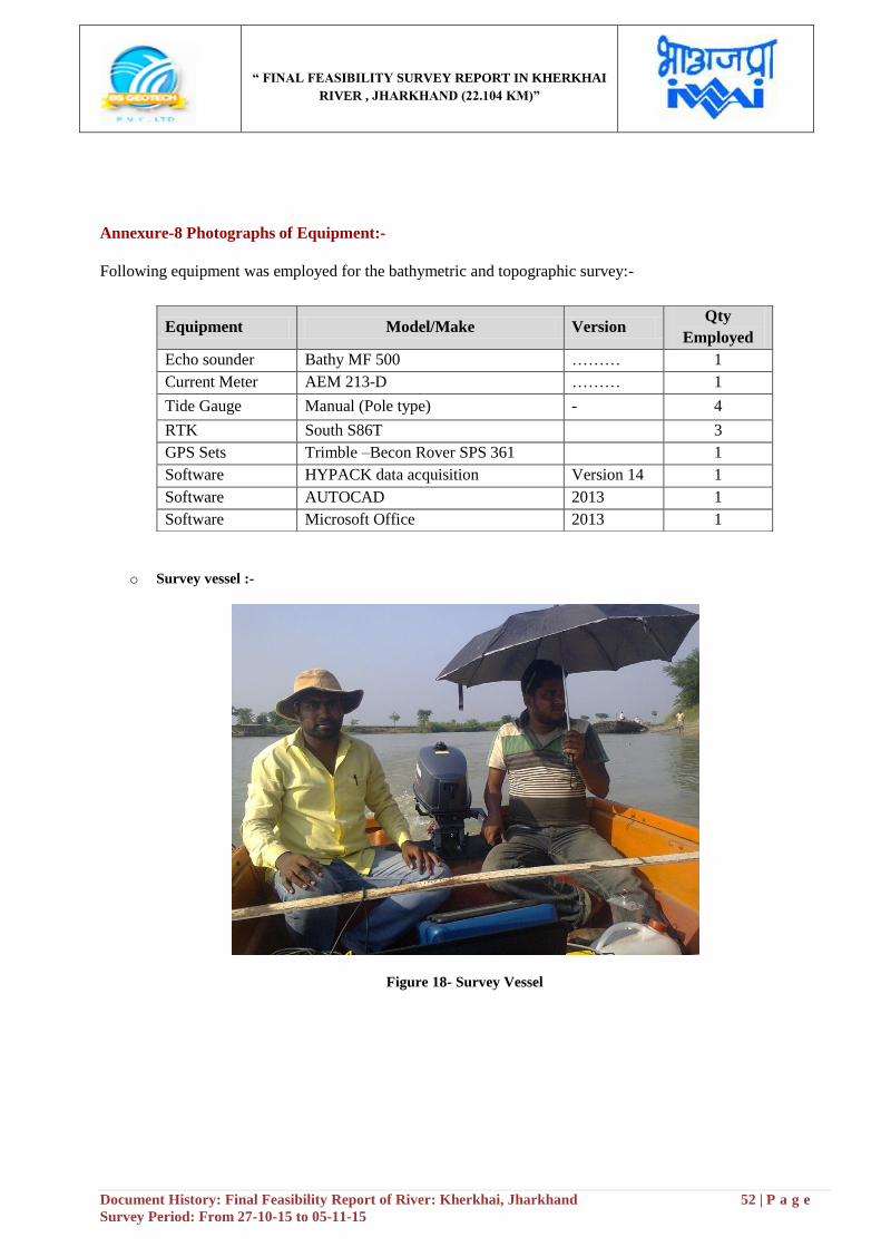
“ FINAL FEASIBILITY SURVEY REPORT IN KHERKHAI
RIVER , JHARKHAND (22.104 KM)”
Document History: Final Feasibility Report of River: Kherkhai, Jharkhand 52 | P a g e
Survey Period: From 27-10-15 to 05-11-15
Annexure-8 Photographs of Equipment:-
Following equipment was employed for the bathymetric and topographic survey:-
o Survey vessel :-
Figure 18- Survey Vessel
Equipment Model/Make Version Qty
Employed
Echo sounder Bathy MF 500 ……… 1
Current Meter AEM 213-D ……… 1
Tide Gauge Manual (Pole type) - 4
RTK South S86T 3
GPS Sets Trimble –Becon Rover SPS 361 1
Software HYPACK data acquisition Version 14 1
Software AUTOCAD 2013 1
Software Microsoft Office 2013 1
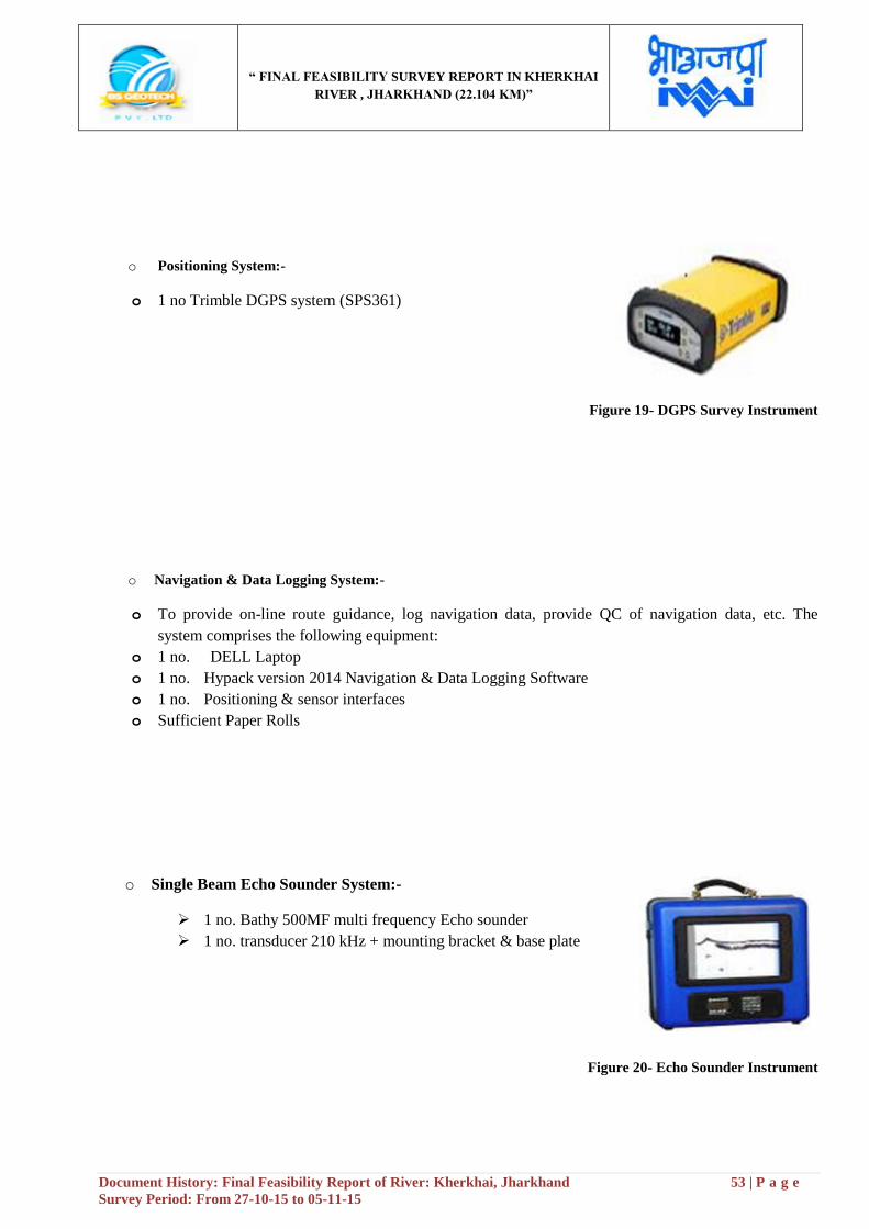
“ FINAL FEASIBILITY SURVEY REPORT IN KHERKHAI
RIVER , JHARKHAND (22.104 KM)”
Document History: Final Feasibility Report of River: Kherkhai, Jharkhand 53 | P a g e
Survey Period: From 27-10-15 to 05-11-15
o Positioning System:-
o 1 no Trimble DGPS system (SPS361)
Figure 19- DGPS Survey Instrument
o Navigation & Data Logging System:-
o To provide on-line route guidance, log navigation data, provide QC of navigation data, etc. The
system comprises the following equipment:
o 1 no. DELL Laptop
o 1 no. Hypack version 2014 Navigation & Data Logging Software
o 1 no. Positioning & sensor interfaces
o Sufficient Paper Rolls
o Single Beam Echo Sounder System:-
1 no. Bathy 500MF multi frequency Echo sounder
1 no. transducer 210 kHz + mounting bracket & base plate
Figure 20- Echo Sounder Instrument

“ FINAL FEASIBILITY SURVEY REPORT IN KHERKHAI
RIVER , JHARKHAND (22.104 KM)”
Document History: Final Feasibility Report of River: Kherkhai, Jharkhand 54 | P a g e
Survey Period: From 27-10-15 to 05-11-15
o Current Meter:-
1 no. current meter (AEM 213-D) was used during water velocity
observation
Figure 21- Current Meter Reading
o Calibration:-
All the equipments of Machinery details are attached in Annexure portion
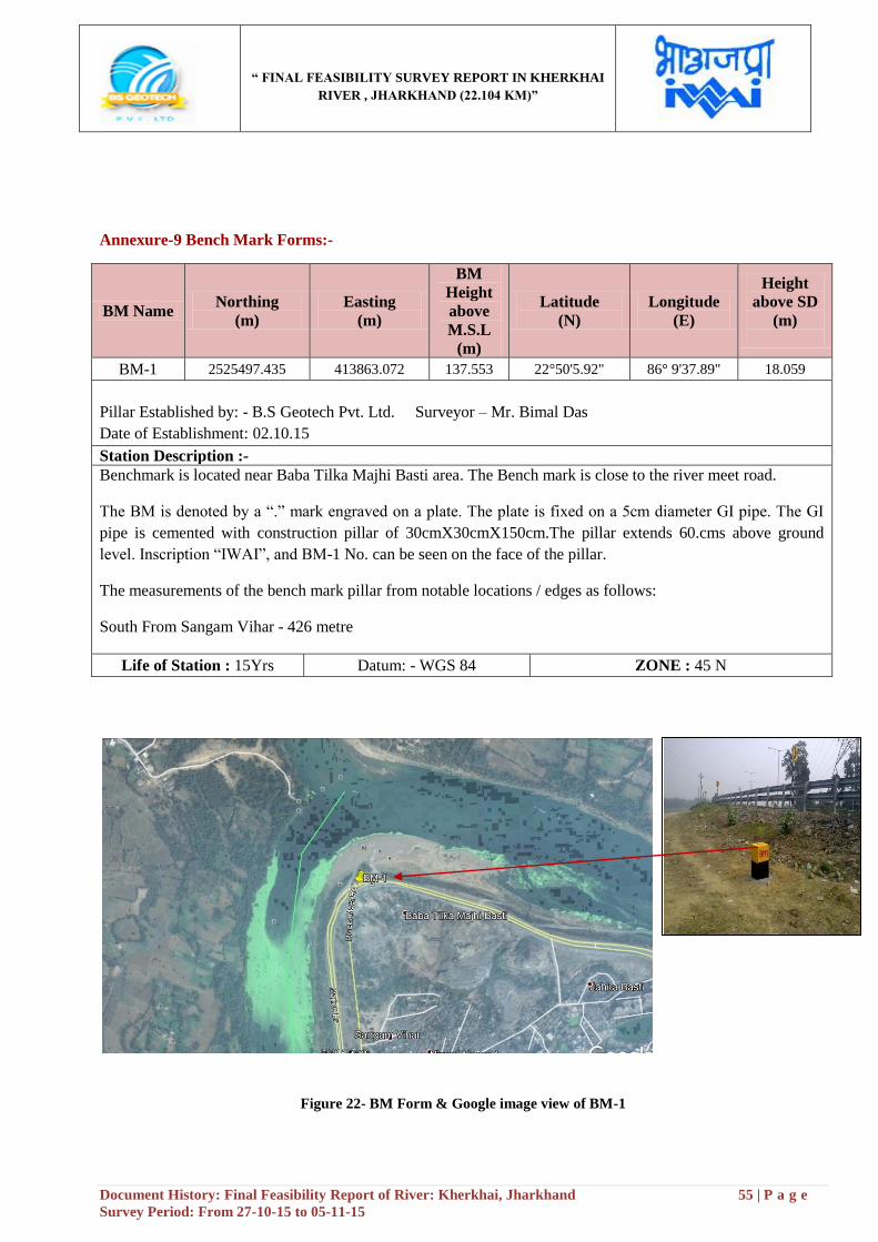
“ FINAL FEASIBILITY SURVEY REPORT IN KHERKHAI
RIVER , JHARKHAND (22.104 KM)”
Document History: Final Feasibility Report of River: Kherkhai, Jharkhand 55 | P a g e
Survey Period: From 27-10-15 to 05-11-15
Annexure-9 Bench Mark Forms:-
Figure 22- BM Form & Google image view of BM-1
BM Name Northing
(m)
Easting
(m)
BM
Height
above
M.S.L
(m)
Latitude
(N)
Longitude
(E)
Height
above SD
(m)
BM-1 2525497.435 413863.072 137.553 22°50'5.92" 86° 9'37.89" 18.059
Pillar Established by: - B.S Geotech Pvt. Ltd. Surveyor – Mr. Bimal Das
Date of Establishment: 02.10.15
Station Description :-
Benchmark is located near Baba Tilka Majhi Basti area. The Bench mark is close to the river meet road.
The BM is denoted by a “.” mark engraved on a plate. The plate is fixed on a 5cm diameter GI pipe. The GI
pipe is cemented with construction pillar of 30cmX30cmX150cm.The pillar extends 60.cms above ground
level. Inscription “IWAI”, and BM-1 No. can be seen on the face of the pillar.
The measurements of the bench mark pillar from notable locations / edges as follows:
South From Sangam Vihar - 426 metre
Life of Station : 15Yrs Datum: - WGS 84 ZONE : 45 N
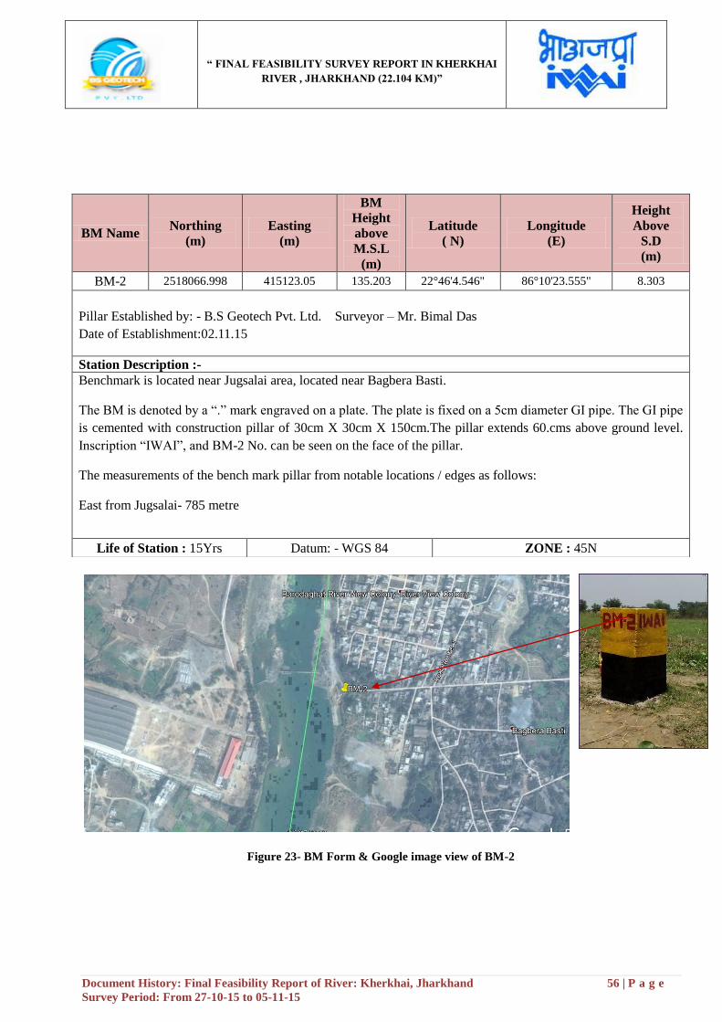
“ FINAL FEASIBILITY SURVEY REPORT IN KHERKHAI
RIVER , JHARKHAND (22.104 KM)”
Document History: Final Feasibility Report of River: Kherkhai, Jharkhand 56 | P a g e
Survey Period: From 27-10-15 to 05-11-15
Figure 23- BM Form & Google image view of BM-2
BM Name Northing
(m)
Easting
(m)
BM
Height
above
M.S.L
(m)
Latitude
( N)
Longitude
(E)
Height
Above
S.D
(m)
BM-2 2518066.998 415123.05 135.203 22°46'4.546" 86°10'23.555" 8.303
Pillar Established by: - B.S Geotech Pvt. Ltd. Surveyor – Mr. Bimal Das
Date of Establishment:02.11.15
Station Description :-
Benchmark is located near Jugsalai area, located near Bagbera Basti.
The BM is denoted by a “.” mark engraved on a plate. The plate is fixed on a 5cm diameter GI pipe. The GI pipe
is cemented with construction pillar of 30cm X 30cm X 150cm.The pillar extends 60.cms above ground level.
Inscription “IWAI”, and BM-2 No. can be seen on the face of the pillar.
The measurements of the bench mark pillar from notable locations / edges as follows:
East from Jugsalai- 785 metre
Life of Station : 15Yrs Datum: - WGS 84 ZONE : 45N
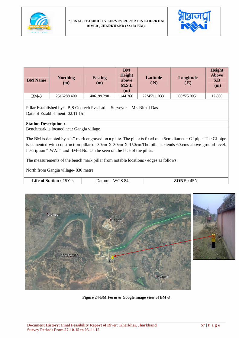
“ FINAL FEASIBILITY SURVEY REPORT IN KHERKHAI
RIVER , JHARKHAND (22.104 KM)”
Document History: Final Feasibility Report of River: Kherkhai, Jharkhand 57 | P a g e
Survey Period: From 27-10-15 to 05-11-15
Figure 24-BM Form & Google image view of BM-3
BM Name Northing
(m)
Easting
(m)
BM
Height
above
M.S.L
(m)
Latitude
( N)
Longitude
( E)
Height
Above
S.D
(m)
BM-3 2516288.400 406199.290 144.360 22°45'11.033" 86°5'5.005" 12.860
Pillar Established by: - B.S Geotech Pvt. Ltd. Surveyor – Mr. Bimal Das
Date of Establishment: 02.11.15
Station Description :-
Benchmark is located near Gangia village.
The BM is denoted by a “.” mark engraved on a plate. The plate is fixed on a 5cm diameter GI pipe. The GI pipe
is cemented with construction pillar of 30cm X 30cm X 150cm.The pillar extends 60.cms above ground level.
Inscription “IWAI”, and BM-3 No. can be seen on the face of the pillar.
The measurements of the bench mark pillar from notable locations / edges as follows:
North from Gangia village- 830 metre
Life of Station : 15Yrs Datum: - WGS 84 ZONE : 45N
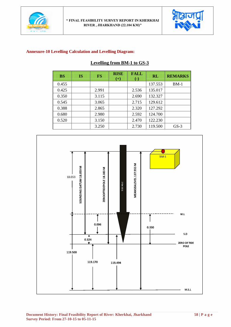
“ FINAL FEASIBILITY SURVEY REPORT IN KHERKHAI
RIVER , JHARKHAND (22.104 KM)”
Document History: Final Feasibility Report of River: Kherkhai, Jharkhand 58 | P a g e
Survey Period: From 27-10-15 to 05-11-15
Annexure-10 Levelling Calculation and Levelling Diagram:
Levelling from BM-1 to GS-3
BS IS FS RISE
(+)
FALL
(-) RL REMARKS
0.455 137.553 BM-1
0.425 2.991 2.536 135.017
0.350 3.115 2.690 132.327
0.545 3.065 2.715 129.612
0.388 2.865 2.320 127.292
0.680 2.980 2.592 124.700
0.520 3.150 2.470 122.230
3.250 2.730 119.500 GS-3
“ FINAL FEASIBILITY SURVEY REPORT IN KHERKHAI
RIVER , JHARKHAND (22.104 KM)”
Document History: Final Feasibility Report of River: Kherkhai, Jharkhand 59 | P a g e
Survey Period: From 27-10-15 to 05-11-15
Levelling from BM-2 to GS-1
BS IS FS RISE
(+)
FALL
(-)
RL
(m) REMARKS
0.341 135.203 BM-2
0.632 2.060 1.719 133.484
0.752 2.980 2.348 131.136
0.378 2.833 2.081 129.055
2.533 2.155 126.900 GS-1
“ FINAL FEASIBILITY SURVEY REPORT IN KHERKHAI
RIVER , JHARKHAND (22.104 KM)”
Document History: Final Feasibility Report of River: Kherkhai, Jharkhand 60 | P a g e
Survey Period: From 27-10-15 to 05-11-15
Levelling from CP-K-11 to GS-2
BS IS FS RISE
(+)
FALL
(-)
RL
(m) REMARKS
1.886 131.892 CP-K11
2.278 0.392 131.500 GS-2

“ FINAL FEASIBILITY SURVEY REPORT IN KHERKHAI
RIVER , JHARKHAND (22.104 KM)”
Document History: Final Feasibility Report of River: Kherkhai, Jharkhand 61 | P a g e
Survey Period: From 27-10-15 to 05-11-15
Annexure-11 Soil Sample Report:
Note: - The position of the Soil sample Reports have been shown at Para no-2.21 (a), page no-23
“ FINAL FEASIBILITY SURVEY REPORT IN KHERKHAI
RIVER , JHARKHAND (22.104 KM)”
Document History: Final Feasibility Report of River: Kherkhai, Jharkhand 62 | P a g e
Survey Period: From 27-10-15 to 05-11-15
“ FINAL FEASIBILITY SURVEY REPORT IN KHERKHAI
RIVER , JHARKHAND (22.104 KM)”
Document History: Final Feasibility Report of River: Kherkhai, Jharkhand 63 | P a g e
Survey Period: From 27-10-15 to 05-11-15
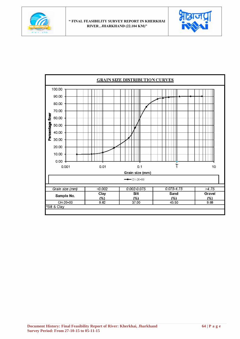
“ FINAL FEASIBILITY SURVEY REPORT IN KHERKHAI
RIVER , JHARKHAND (22.104 KM)”
Document History: Final Feasibility Report of River: Kherkhai, Jharkhand 64 | P a g e
Survey Period: From 27-10-15 to 05-11-15
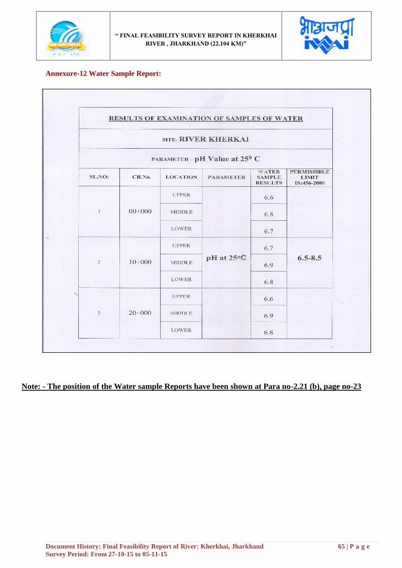
“ FINAL FEASIBILITY SURVEY REPORT IN KHERKHAI
RIVER , JHARKHAND (22.104 KM)”
Document History: Final Feasibility Report of River: Kherkhai, Jharkhand 65 | P a g e
Survey Period: From 27-10-15 to 05-11-15
Annexure-12 Water Sample Report:
Note: - The position of the Water sample Reports have been shown at Para no-2.21 (b), page no-23
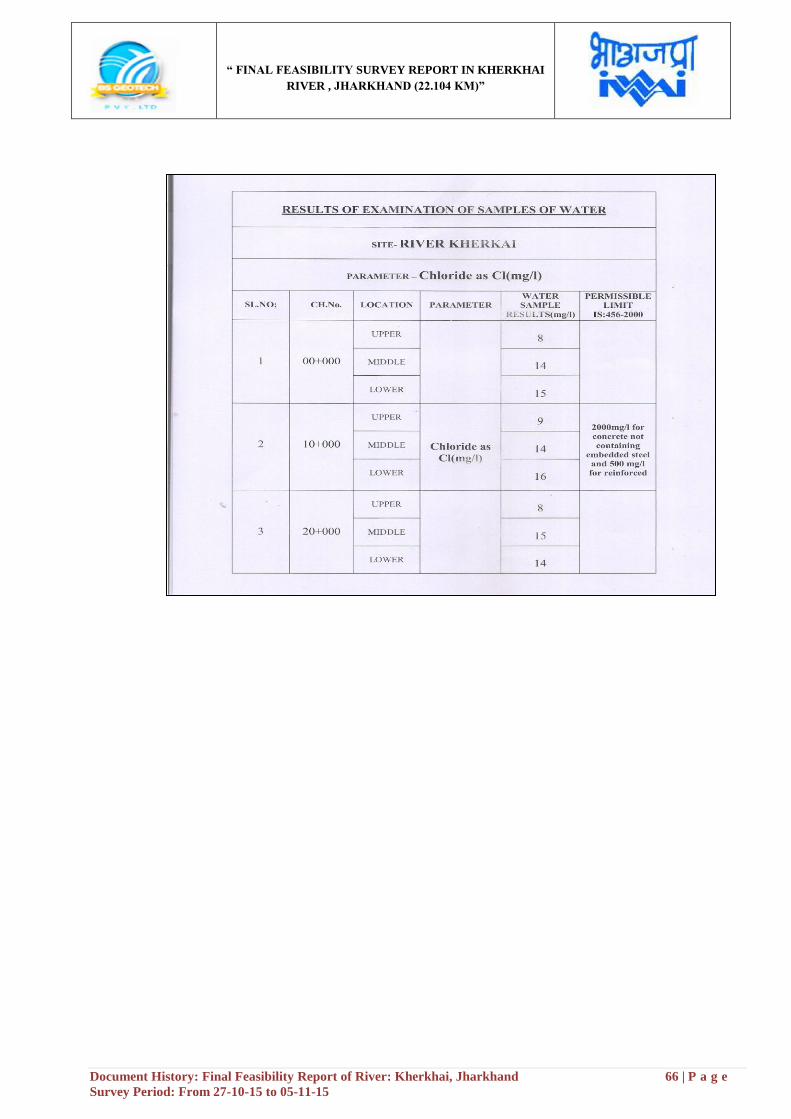
“ FINAL FEASIBILITY SURVEY REPORT IN KHERKHAI
RIVER , JHARKHAND (22.104 KM)”
Document History: Final Feasibility Report of River: Kherkhai, Jharkhand 66 | P a g e
Survey Period: From 27-10-15 to 05-11-15
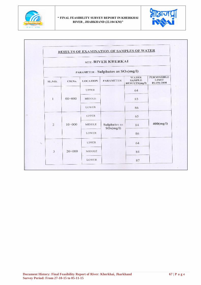
“ FINAL FEASIBILITY SURVEY REPORT IN KHERKHAI
RIVER , JHARKHAND (22.104 KM)”
Document History: Final Feasibility Report of River: Kherkhai, Jharkhand 67 | P a g e
Survey Period: From 27-10-15 to 05-11-15
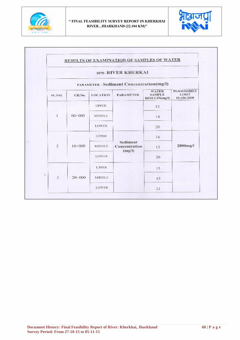
“ FINAL FEASIBILITY SURVEY REPORT IN KHERKHAI
RIVER , JHARKHAND (22.104 KM)”
Document History: Final Feasibility Report of River: Kherkhai, Jharkhand 68 | P a g e
Survey Period: From 27-10-15 to 05-11-15
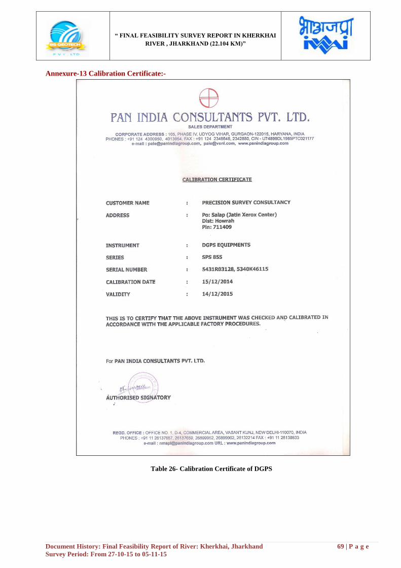
“ FINAL FEASIBILITY SURVEY REPORT IN KHERKHAI
RIVER , JHARKHAND (22.104 KM)”
Document History: Final Feasibility Report of River: Kherkhai, Jharkhand 69 | P a g e
Survey Period: From 27-10-15 to 05-11-15
Annexure-13 Calibration Certificate:-
Table 26- Calibration Certificate of DGPS
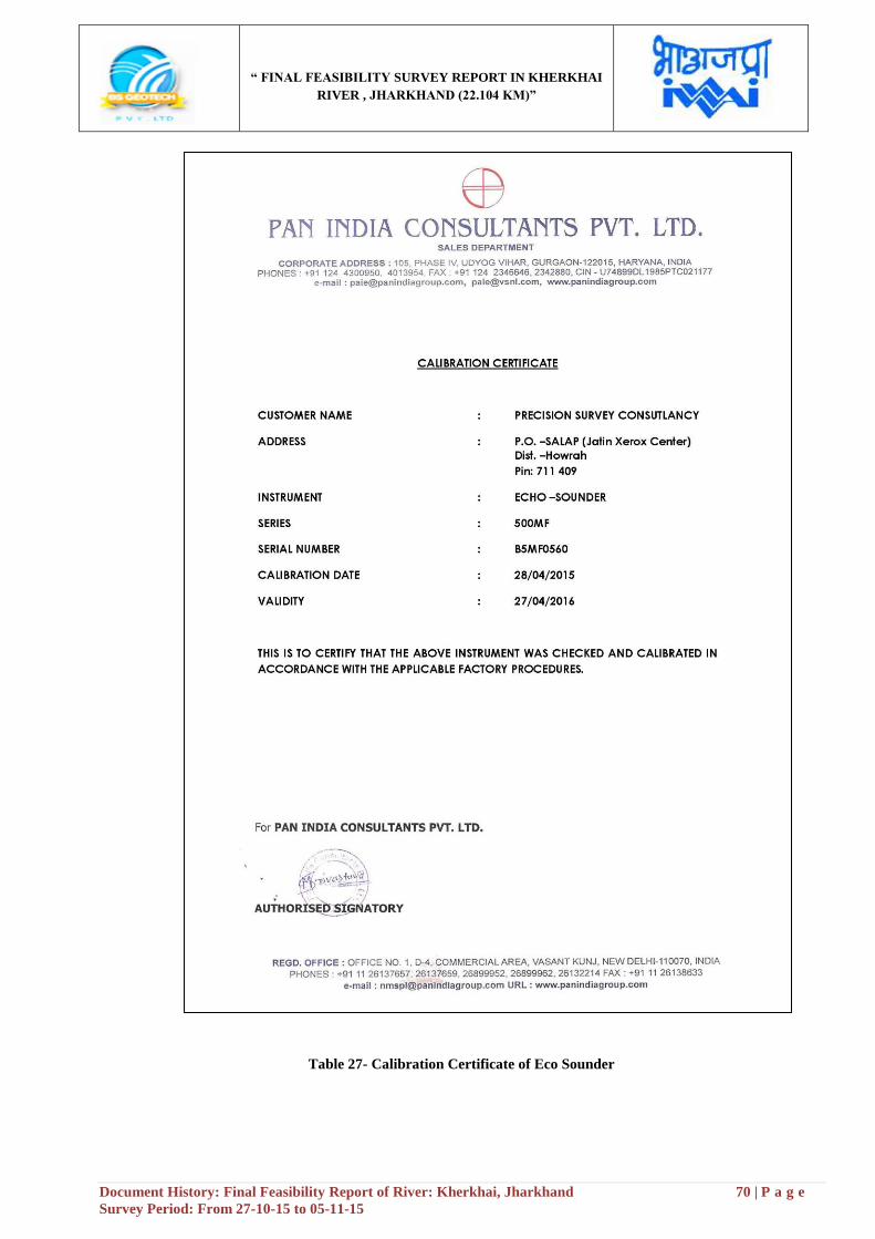
“ FINAL FEASIBILITY SURVEY REPORT IN KHERKHAI
RIVER , JHARKHAND (22.104 KM)”
Document History: Final Feasibility Report of River: Kherkhai, Jharkhand 70 | P a g e
Survey Period: From 27-10-15 to 05-11-15
Table 27- Calibration Certificate of Eco Sounder
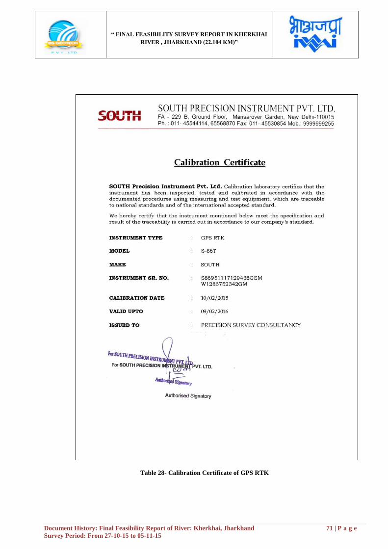
“ FINAL FEASIBILITY SURVEY REPORT IN KHERKHAI
RIVER , JHARKHAND (22.104 KM)”
Document History: Final Feasibility Report of River: Kherkhai, Jharkhand 71 | P a g e
Survey Period: From 27-10-15 to 05-11-15
Table 28- Calibration Certificate of GPS RTK
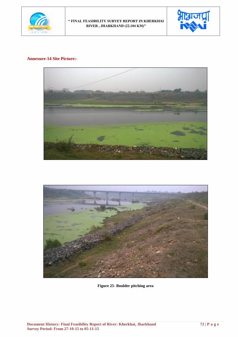
“ FINAL FEASIBILITY SURVEY REPORT IN KHERKHAI
RIVER , JHARKHAND (22.104 KM)”
Document History: Final Feasibility Report of River: Kherkhai, Jharkhand 72 | P a g e
Survey Period: From 27-10-15 to 05-11-15
Annexure-14 Site Picture:-
Figure 25- Boulder pitching area
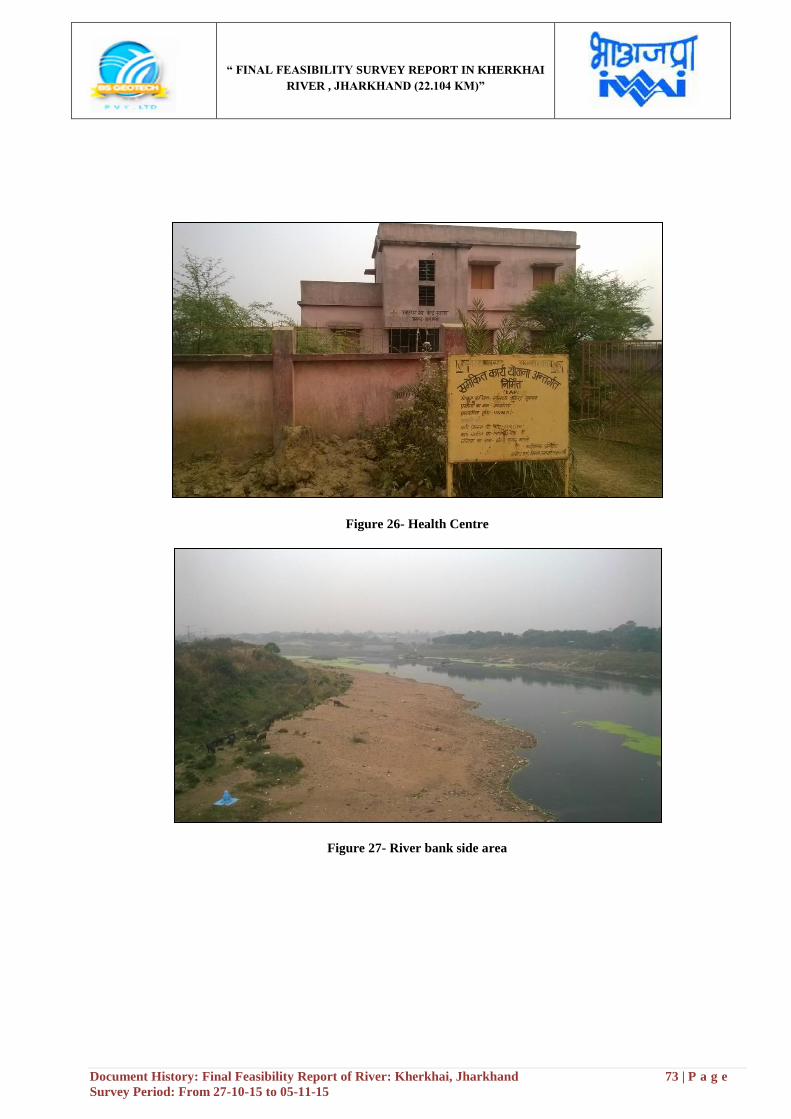
“ FINAL FEASIBILITY SURVEY REPORT IN KHERKHAI
RIVER , JHARKHAND (22.104 KM)”
Document History: Final Feasibility Report of River: Kherkhai, Jharkhand 73 | P a g e
Survey Period: From 27-10-15 to 05-11-15
Figure 26- Health Centre
Figure 27- River bank side area
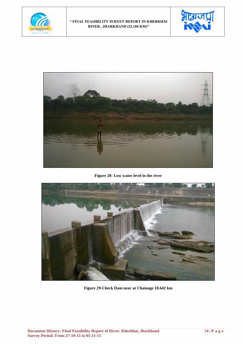
“ FINAL FEASIBILITY SURVEY REPORT IN KHERKHAI
RIVER , JHARKHAND (22.104 KM)”
Document History: Final Feasibility Report of River: Kherkhai, Jharkhand 74 | P a g e
Survey Period: From 27-10-15 to 05-11-15
Figure 28- Low water level in the river
Figure 29-Check Dam near at Chainage 10.642 km
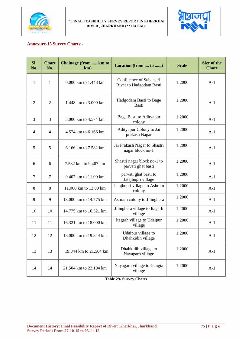
“ FINAL FEASIBILITY SURVEY REPORT IN KHERKHAI
RIVER , JHARKHAND (22.104 KM)”
Document History: Final Feasibility Report of River: Kherkhai, Jharkhand 75 | P a g e
Survey Period: From 27-10-15 to 05-11-15
Annexure-15 Survey Charts:-
Sl.
No.
Chart
No.
Chainage (from ..... km to
.... km) Location (from .... to ......) Scale
Size of the
Chart
1 1 0.000 km to 1.448 km Confluence of Subansiri
River to Hadgodam Basti 1:2000 A-1
2 2 1.448 km to 3.000 km Hadgodam Basti to Bage
Basti 1:2000
A-1
3 3 3.000 km to 4.574 km Bage Basti to Adityapur
colony 1:2000
A-1
4 4 4.574 km to 6.166 km Adityapur Colony to Jai
prakash Nagar 1:2000
A-1
5 5 6.166 km to 7.582 km Jai Prakash Nagar to Shastri
nagar block no-1 1:2000
A-1
6 6 7.582 km to 9.407 km Shastri nagar block no-1 to
parvati ghat basti 1:2000
A-1
7 7 9.407 km to 11.00 km parvati ghat basti to
Jatajhupri village 1:2000
A-1
8 8 11.000 km to 13.00 km Jatajhupri village to Ashram
colony 1:2000
A-1
9 9 13.000 km to 14.775 km Ashram colony to Jilingbera 1:2000
A-1
10 10 14.775 km to 16.321 km Jilingbera village to Itagarh
village 1:2000
A-1
11 11 16.321 km to 18.000 km Itagarh village to Udaipur
village 1:2000
A-1
12 12 18.000 km to 19.844 km Udaipur village to
Dhahkidih village 1:2000
A-1
13 13 19.844 km to 21.504 km Dhahkidih village to
Nayagarh village 1:2000
A-1
14 14 21.504 km to 22.104 km Nayagarh village to Gangia
village 1:2000
A-1
Table 29- Survey Charts