Embed Size (px)
Citation preview
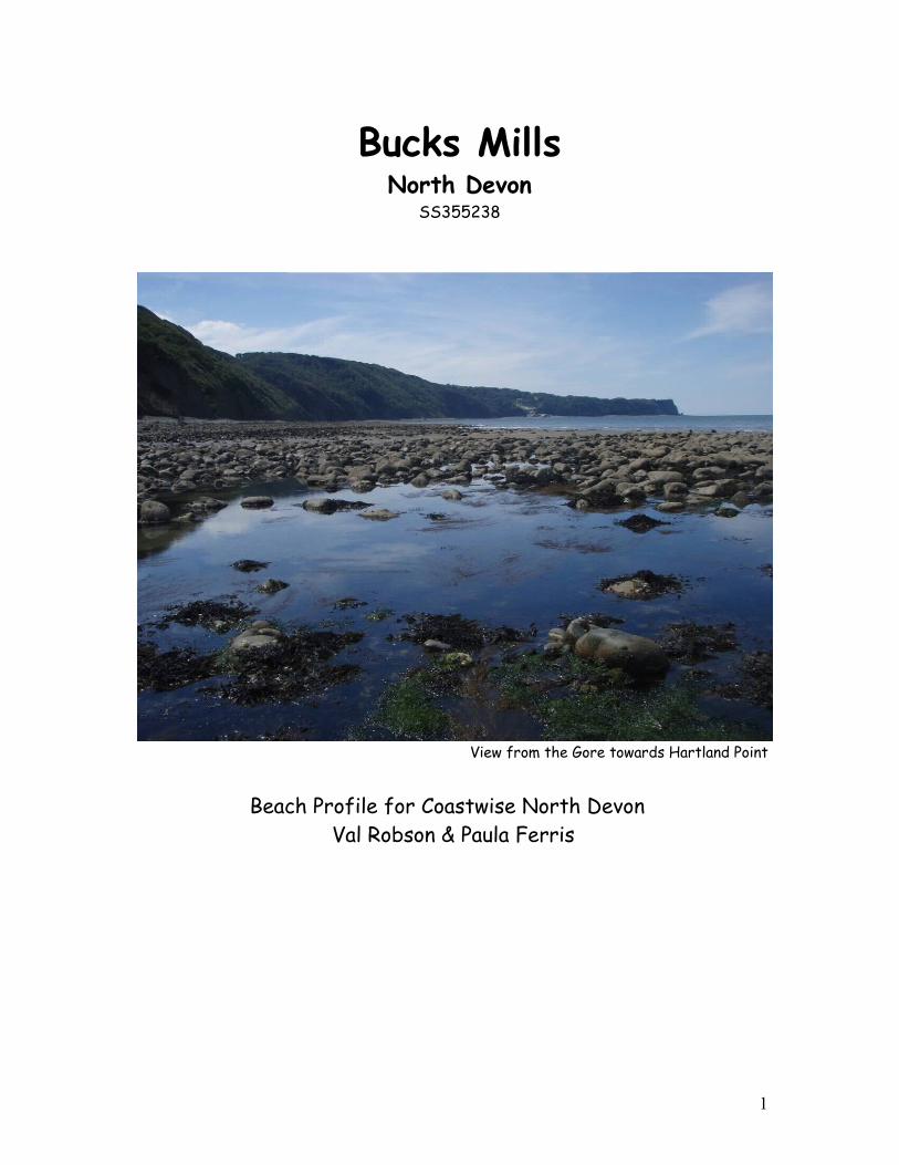
View from the Gore towards Hartland Point
Beach Profile for Coastwise North Devon Val Robson & Paula Ferris
1
Bucks MillsNorth Devon
SS355238
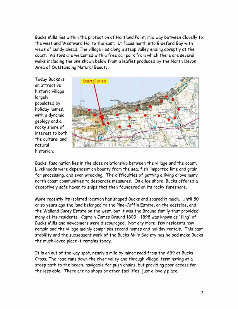
Bucks Mills lies within the protection of Hartland Point, mid way between Clovelly to the west and Westward Ho! to the east. It faces north into Bideford Bay with views of Lundy ahead. The village lies along a steep valley ending abruptly at the coast. Visitors are welcomed with a free car park from which there are several walks including the one shown below from a leaflet produced by the North Devon Area of Outstanding Natural Beauty.
Today Bucks is an attractive historic village, largely populated by holiday homes, with a dynamic geology and a rocky shore of interest to both the cultural and natural historian.
Bucks’ fascination lies in the close relationship between the village and the coast. Livelihoods were dependent on bounty from the sea, fish, imported lime and grain for processing, and even wrecking. The difficulties of getting a living drove many north coast communities to desperate measures. On a lee shore, Bucks offered a deceptively safe haven to ships that then foundered on its rocky foreshore.
More recently its isolated location has shaped Bucks and spared it much. Until 50 or so years ago the land belonged to the Pine-Coffin Estate, on the eastside, and the Walland Carey Estate on the west, but it was the Braund family that provided many of its residents. Captain James Braund 1809 – 1898 was known as 'King' of Bucks Mills and newcomers were discouraged. Not any more, few residents now remain and the village mainly comprises second homes and holiday rentals. This past stability and the subsequent work of the Bucks Mills Society has helped make Bucks the much-loved place it remains today.
It is an out of the way spot, nearly a mile by minor road from the A39 at Bucks Cross. The road runs down the river valley and through village, terminating at a steep path to the beach, navigable for push chairs, but providing poor access for the less able. There are no shops or other facilities, just a lovely place.
2

The car park interpretation board captures the verdant feel of the valley. Trees, cottages and their greenery, and the stream with its distinctive plant-life fringe the route to the coast. The road becomes a path at the cliff where the houses abut the edge and are vulnerable to erosion from sea and air. This aerial erosion has created the gently shelving hog’s-back cliffs along this stretch of coast to Clovelly which support mixed oak woodland and scrub, and through which the coast path meanders.
The shingle beach comprises upturned layers of hard sandstone and softer shales worn down differentially into ridges. The beds run roughly parallel to the coast. Scattered over these ridges are boulders and pebbles, which have eroded from the cliffs, and are being swept eastwards by the action of the tides towards Westward Ho! pebble ridge.
3

This very conspicuous geology provides plenty of nooks and crannies for marine life. Shore fish and prawns lurk amongst the weeds in summer. Fish swarm over the rocks to feed and can even sometimes be seen from the cliffs.
The rocks and plentiful large boulders provide for easy scrambling and there is good swimming at low tide when some sand is exposed, particularly at the Gut opposite the path onto the shore. The rock was blasted out here in Elizabethan times to provide a passageway for local trading boats.
To the west lies the Gore, a rocky spit which looks like a man-made jetty, but is neither this nor the start of a causeway to Lundy built by the Devil as suggested by local legend. More likely it is the remains of a substantial rock-fall, eroded into its distinctive shape by tides and currents.
Coastal waterfalls are a feature of this northern coastline. The waterfall at Bucks Mills may be a trickle in summer but can be spectacular after heavy rain. It has been diverted to serve nearby mills now lost to cliff falls. Mill House, still standing, is perilously close to the eroding cliff edge.
The small stone cabin (right) on the path to the beach was the summer home and studio of artists Judith Ackland and Mary Stella Edwards. Bucks has been the inspiration of artists including J M W Turner and local artist James Paterson.
The plentiful seaweed cover on the shore suggests a sheltered shore. It is shielded from the prevailing south westerly winds, and spared the surf that affects most local beaches. The beach slope is significant and the tidal range sufficient to expose a good expanse of rocky shore as well as a rim of sand at low tide. The slope of the shore means that the upper and mid shore seaweed zones are
4

conflated, with much of the former being further obscured by the covering of boulders and pebbles. Evidence of other marine processes is limited. The shore is sufficiently far from the mouth of the Estuary that its salinity is little affected, and although long shore drift is gradually moving boulders along, there is little sign of the debris deposited by the local circulation of currents on beaches elsewhere in the bay - the shore being remarkably clear of litter.
Man’s ImpactThe days when Bucks Mills was a scene of industry are long over, and the evidence that remains has a charm and interest all the greater for being uncluttered by any recent additions, apart from the helpful interpretation boards. The scene could well be that of 100 years ago were it not for the damage caused by the slowly encroaching sea to the vulnerable cliffs.
Big boulders visible at low shore on low tides are said to be from an Elizabethan harbour. Bucks has had a quay and access for shipping for centuries. The quay at the top of the beach still carries winches, now rusty from disuse, for drawing boats up the Gut, originally blasted through the rocky foreshore to serve the lime trade.
D. Hubbard-Fielder, says in The Story of Bucks Mills & Bucks Cross. “Fishing was once a main industry with herring, mackerel, whiting, lobsters and prawns being the most popular catches. When fishing declined and the lime kilns stopped working, villagers risked sailing the seventeen miles of open sea to Lundy to work in the island's granite quarry.” Despite the presence of pots on the quay most of the limited local commercial fishing is now based at Clovelly.
The remains of one of three Bucks limekilns, dating from 1760, dominate the beach, though probably not for much longer, as the structure is already declared dangerous, and will be taken by the sea in time. Horse drawn carts took the lime to be winched up a steep ramp as depicted on the interpretation board.
The beach is Crown property. Twentieth century visitors have been encouraged by notices to use
5

the foreshore, and to fish freely. There is no other evidence of “management”, apart from the interpretation boards and occasional upkeep of the quay wall and adjoining buildings. Other buildings such as the limekiln are at risk but sustaining them against the attack of the sea would be costly even if practicable.
The shore
The sheltered nature of the shore allows seaweed to settle and thrive. The geology of the rocks and the weed provides plenty of cover for animals. The presence of exposed sand provides material for Honeycomb worms to form small reefs, a Biodiversity Action Plan habitat. The Gore acts as a headland around which currents stir up nutrients and attract animals to feed.
This is a recipe for abundance, and historically there have been good fish populations. There are flat fish spawning grounds between Bucks and Clovelly, where herring are still fished. A fuller picture will emerge from Devon Wildlife Trust’s Living Seas project currently underway. Shore abundance is limited by the relative narrowness of the shore and the damaging effect of the boulders and pebbles traveling across the rocks. Limpets are plentiful, shore fish such as blennies (above), rockling, and scorpion fish are found in the crevice pools, dog whelks on the lower shore, and star ascidians exposed under stones and rocks at low tide (below right). The good population of crabs includes large numbers of Spider Crabs in summer, when they come inshore to moult their carapaces prior to mating in the bay (below left). Prawns are plentiful after a big swell.
Bucks Mills – a snapshot of shore life 20 August 2008
6

Species – upper & mid shore
Black tar lichen CBlack lichen OBarnacles sp SASmall periwinkle CRough periwinkle FLimpets CMussels OBeadlet anemone FSnakelocks anemone FThick Topshell F
Mid ShoreSea lettuce AGut weed FKnotted wrack CToothed wrack CBladder wrack CWireweed CCarragheen CEncrusting red algae ALaver F Pepper dulse FBarnacles sp. AFlat periwinkle RBeadlet anemone CDog whelk RLimpets AFlat or purple top shell OThick top shell CBlenny OBreadcrumb sponge FSnakelocks anemone RShore crab O
Scorpion fish
Species lower shore
Sea lettuce CGut weed FToothed wrack AOarweed FSea belt RCarragheen FEncrusting red algae CCorallina ALaver CPepper dulse ABarnacles sp AVolcano barnacles FBreadcrumb Sponge CBeadlet anemone FDog whelk ALimpets AFlat or purple top shell CHoneycomb Worm CKeel worms CPorcelain crabs CStrawberry anemone OSandmason worms OStar ascidian RChiton OGem anemone RBlenny RSpider crab O
Codes: SA Super Abundant, A Abundant, C Common, F frequent, O Occasional, R Rare
Clovelly Bay - J M W Turner
7