Embed Size (px)
Citation preview
Intro
du
ction
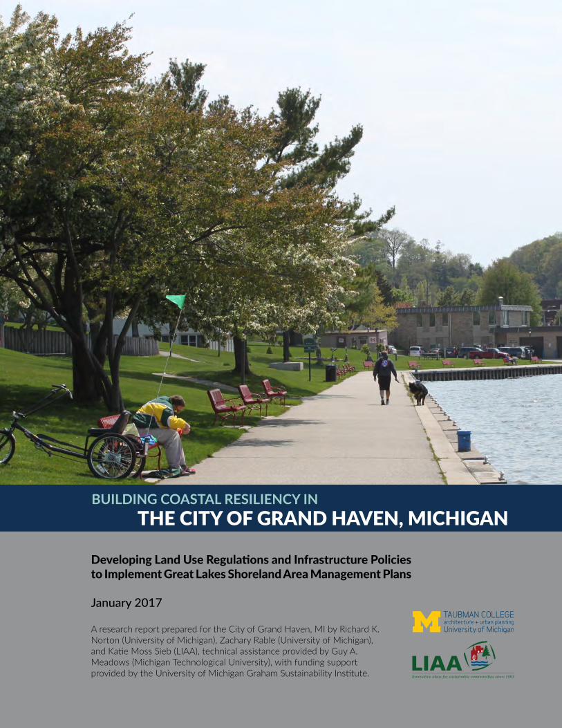
THE CITY OF GRAND HAVEN, MICHIGANBUILDING COASTAL RESILIENCY IN
Developing Land Use Regulations and Infrastructure Policies to Implement Great Lakes Shoreland Area Management Plans
January 2017
A research report prepared for the City of Grand Haven, MI by Richard K. Norton (University of Michigan), Zachary Rable (University of Michigan), and Katie Moss Sieb (LIAA), technical assistance provided by Guy A. Meadows (Michigan Technological University), with funding support provided by the University of Michigan Graham Sustainability Institute.
ACKNOWLEDGMENTSThis report outlines the main findings from a year-long research project conducted in Grand Haven, Michigan. The project team included Dr. Richard K. Norton and Zachary Rable from the University of Michigan, Katie Moss Sieb from the Land Information Access Association (LIAA), and Dr. Guy A. Meadows from Michigan Technological University. The project was funded by the Graham Sustainability Institute through the University of Michigan Integrated Assessment Center, with support from the Michigan Coastal Zone Management Program, Office of the Great Lakes, Michigan Department of Environmental Quality, and the National Oceanic and Atmospheric Administration.
A special thank you is owed to Jennifer Howland, City of Grand Haven Community Development Manager and Stacey Fedewa, Grand Haven Charter Township Community Development Director, as well as the full planning commissions of the City and Township of Grand Haven. Without their support and participation, this project would not have been possible.

TABLE OF CONTENTS1. Introduction .........................................................................................................2
Project Relevance ...............................................................................................4 Process Overview .............................................................................................4 Key Findings ........................................................................................................6 Overview of Coastal Assets and Challenges ................................................7
2. Stormwater Management ..............................................................................14 Current Stormwater Efforts .......................................................................... 15 New Requirements for Stormwater ............................................................ 16 Policy Options .................................................................................................. 17
3. Shoreline Development in the North Shore District .............................. 22 North Shore Zoning District ......................................................................... 24 Policy Options .................................................................................................. 24 Conclusion on North Shore Policy Options ............................................... 38
4. High-Risk Flooding .......................................................................................... 40 High-Risk Flooding Area Policy Options .................................................... 41
5. Conclusion ......................................................................................................... 44
Appendix A: City of St. Joseph, Michigan Zoning Ordinance ExcerptAppendix B: Other Resources
Developing Land Use Regulations and Infrastructure Policies to Implement Great Lakes Shoreland Area Management Plans
BUILDING COASTAL RESILIENCY IN GRAND HAVEN
• Excerpt from Living on the Coast: Protecting Investments in Shore Property on the Great Lakes by the U.S. Army Corps of Engineers and the University of Wisconsin Sea Grant
• Excerpt from Mitigation Ideas: A Resource for Reducing Risk to Natural Hazards by FEMA
• Excerpt from No Adverse Impact: A Toolkit For Common Sense Floodplain Management by the Association of State Flood Plain Managers
• Excerpt from Low Impact Development Manual for Michigan: A Design Guide for Implementers and Reviewers by the Southeast Michigan Council of Governments (SEMCOG)
• A resource guide of example model ordinances on a variety of coastal resiliency concepts.

2
1Introduction
Intro
du
ction
3
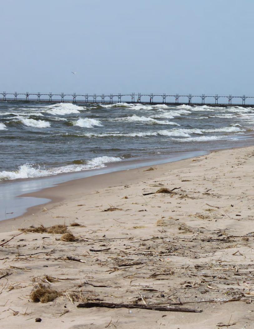
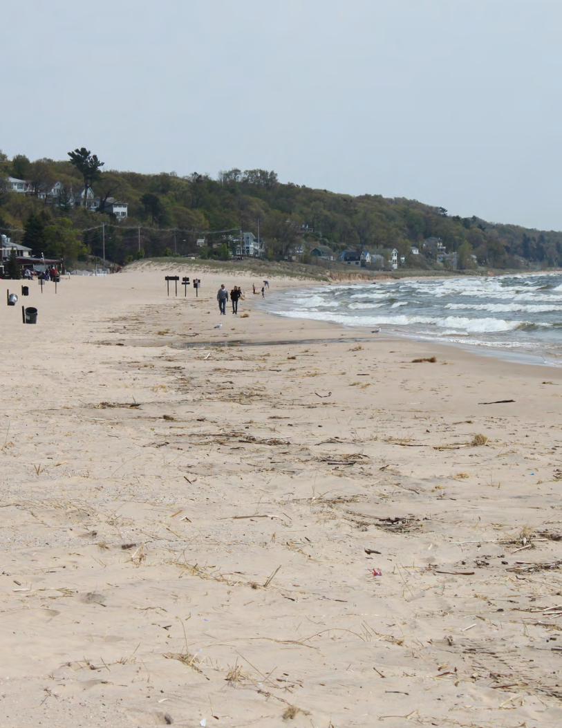
INTRODUCTIONThe City and Township of Grand Haven are located on the western side of the state of Michigan and sit along the scenic shoreline of Lake Michigan. Grand Haven’s coastal areas offer recreational, cultural, and environmental benefits to the community through a network of wetlands, beaches, sand dunes, and sensitive habitats. Homes along the shoreline are high-quality and high-value, and residents living in the near-shore area enjoy an exceptional quality of life defined by the coast. Certainly, the Grand Haven community stands out as one of the State’s most-prized beach communities. The area has been ranked nationally as one of the best beaches in America,1 within the top 10 best places in the country to retire,2 and one of the most charming small towns in Michigan.3
However, coastal jurisdictions along the Great Lakes face a unique set of issues that require careful long-term management and careful policy solutions to properly address. While the Great Lakes provide enormous aesthetic and economic value, they are also dynamic systems that endanger, at times, those who live and play along their shores. As the water levels of the Great Lakes fluctuate annually and decadally, homes and infrastructure built along the shoreline can be at risk during times of high standing water levels and storms. During prolonged periods of low standing water levels, encroaching development can restrict the natural movement of wetlands, dunes, and other coastal systems, causing irreparable environmental damage. A range of government staff and departments are needed to fully protect development, human health, and sensitive natural resources in the near shorelands, and often, local officials do not have access to the depth of information and data needed to make wise decisions.
This report is the result of a research project titled Developing Land Use Regulations and Infrastructure Policies to Implement Great Lakes Shoreland Area Management Plans (“Implementing Adaptation”), conducted in the City of Grand Haven and Grand Haven Charter Township from January to December of 2016. The purpose of the project was to develop a range of policy options that each local government might consider adopting in order to better protect their coastal areas and to address challenges related to changing water levels on the Great Lakes.
Because both the City of Grand Haven and Grand Haven Charter Township were involved in the project concurrently, the first part of this report addresses issues and activities common to both the city and the township. Following that introduction, discussion and recommendations made below with regard to key findings and subsequent topics relate specifically to the City of Grand Haven. The
1 http://www.coastalliving.com/travel/top-10/best-beaches-usa/grand-haven-michigan-beach2 http://www.cntraveler.com/galleries/2016-03-03/the-10-best-places-in-the-world-to-retire/8 3 http://www.onlyinyourstate.com/michigan/small-towns-mi/
ABOUT THIS REPORTThis report is the result of a research project titled Developing Land Use Regulations and Infrastructure Policies to Implement Great Lakes Shoreland Area Management Plans (“Implementing Adaptation”), conducted in the City of Grand Haven and Grand Haven Charter Township from January to December of 2016.
4
report outlines each coastal challenge identified by local officials and summarizes policy options that the City of Grand Haven might adopt in order to protect coastal areas through various policies and ordinances. As such, this report also contains a number of helpful maps, model ordinances, and case studies.
PROJECT RELEVANCE
This research project sought to develop mechanisms for the City and Township of Grand Haven to implement their newly adopted master plans, primarily through revisions of their zoning codes or other policy options, to more fully address Lake Michigan shoreline dynamics related to lake level fluctuations.
The City of Grand Haven and Grand Haven Charter Township were selected to participate in this research project as a result of each community’s work to adopt master plans through the Resilient Michigan program. Community planners from the Land Information Access Association (LIAA), developed the Resilient Michigan program in 2012 to help local governments in Michigan plan for greater resiliency in the face of changing conditions, mainly to environmental and economic systems. Technical assistance from the University of Michigan and Michigan Technological University, along with funding from Michigan’s Coastal Zone Management program, added a coastal resiliency lens to the project. Coastal communities throughout Michigan including Grand Haven, St. Joseph, Ludington, Holland, and others have adopted Master Plans through the Resilient Michigan program. The “Implementing Adaptation” project leverages the work completed in the City of Grand Haven and Grand Haven Charter Township’s Master Plan by identifying specific policy options the community could adopt to further the resiliency goals identified in their plans.
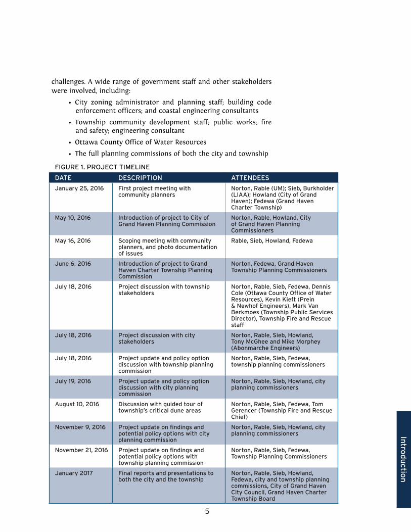
PROCESS OVERVIEWThe process to develop the recommendations in this report involved first identifying coastal assets and challenges and then investigating adaptive opportunities. In each phase, the project team worked with community leaders and stakeholders in order to ensure the findings accurately reflect each community’s conditions and that the policy recommendations are relevant and appropriate both administratively and politically. Figure 1 on the next page illustrates the timeline followed for this project.
1. IDENTIFYING COASTAL ASSETS AND CONCERNS
Planning staff in each community organized a number of meetings and discussions on behalf of the project team. The purpose of these initials meetings was to identify the city and township’s key coastal
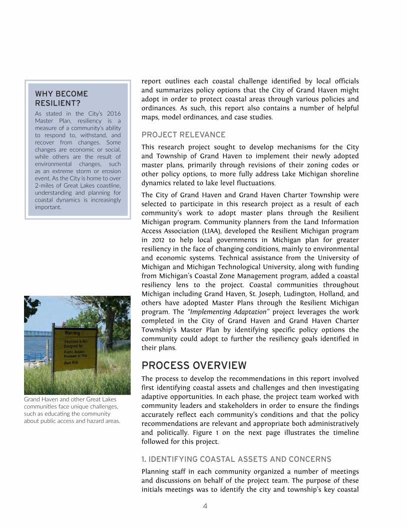
WHY BECOME RESILIENT?As stated in the City’s 2016 Master Plan, resiliency is a measure of a community’s ability to respond to, withstand, and recover from changes. Some changes are economic or social, while others are the result of environmental changes, such as an extreme storm or erosion event. As the City is home to over 2-miles of Great Lakes coastline, understanding and planning for coastal dynamics is increasingly important.
Grand Haven and other Great Lakes communities face unique challenges, such as educating the community about public access and hazard areas.
Intro
du
ction
5
challenges. A wide range of government staff and other stakeholders were involved, including:
• City zoning administrator and planning staff; building code enforcement officers; and coastal engineering consultants
• Township community development staff; public works; fire and safety; engineering consultant
• Ottawa County Office of Water Resources
• The full planning commissions of both the city and township
FIGURE 1. PROJECT TIMELINE
DATE DESCRIPTION ATTENDEES
January 25, 2016 First project meeting with community planners
Norton, Rable (UM); Sieb, Burkholder (LIAA); Howland (City of Grand Haven); Fedewa (Grand Haven Charter Township)
May 10, 2016 Introduction of project to City of Grand Haven Planning Commission
Norton, Rable, Howland, City of Grand Haven Planning Commissioners
May 16, 2016 Scoping meeting with community planners, and photo documentation of issues
Rable, Sieb, Howland, Fedewa
June 6, 2016 Introduction of project to Grand Haven Charter Township Planning Commission
Norton, Fedewa, Grand Haven Township Planning Commissioners
July 18, 2016 Project discussion with township stakeholders
Norton, Rable, Sieb, Fedewa, Dennis Cole (Ottawa County Office of Water Resources), Kevin Kieft (Prein & Newhof Engineers), Mark Van Berkmoes (Township Public Services Director), Township Fire and Rescue staff
July 18, 2016 Project discussion with city stakeholders
Norton, Rable, Sieb, Howland, Tony McGhee and Mike Morphey (Abonmarche Engineers)
July 18, 2016 Project update and policy option discussion with township planning commission
Norton, Rable, Sieb, Fedewa, township planning commissioners
July 19, 2016 Project update and policy option discussion with city planning commission
Norton, Rable, Sieb, Howland, city planning commissioners
August 10, 2016 Discussion with guided tour of township’s critical dune areas
Norton, Rable, Sieb, Fedewa, Tom Gerencer (Township Fire and Rescue Chief)
November 9, 2016 Project update on findings and potential policy options with city planning commission
Norton, Rable, Sieb, Howland, city planning commissioners
November 21, 2016 Project update on findings and potential policy options with township planning commission
Norton, Rable, Sieb, Fedewa, Township Planning Commissioners
January 2017 Final reports and presentations to both the city and the township
Norton, Rable, Sieb, Howland, Fedewa, city and township planning commissions, City of Grand Haven City Council, Grand Haven Charter Township Board
6
2. INVESTIGATING ADAPTIVE OPPORTUNITIES
Community stakeholders also identified policies that might help address coastal management challenges. Primarily through discussions with the planning commissions, the project team was able to create an opportunity for the community to creatively identify possible policies that might help address the unique coastal management challenges in each community. The resulting list of ideas was supplemented by the project team’s independent research and was evaluated for political viability, potential benefits, potential disadvantages, and potential governmental cost to implement through additional meetings with the planning staff and commissioners. Selections of policy options were presented to the full planning commissions of the city and township, and their feedback helped define the final policy options included in this report.
KEY FINDINGS FOR THE CITY OF GRAND HAVENThe City of Grand Haven and Grand Haven Charter Township share many coastal assets and enjoy a similar cultural identity related to the coastal amenities they share. As a result of their strong relationship, the city and township collaborated during the master planning process on a number of land use and environmental topics. However, the city and the township face different coastal management challenges given their different development patterns and land use characteristics. The remainder of this report focuses specifically on the key findings related to the City of Grand Haven and the policy options most relevant to the city in light of those findings, although several of the options discussed might be best applied regionally or through further collaboration with Grand Haven Charter Township.
The City of Grand Haven is primarily urban, with little opportunity for significant development on previously undeveloped land. Development pressure, however, primarily in the form of demand for new or retrofitted single-family homes, is slowly rising in recent years. The city’s primary concerns related to their shoreland areas are related to stormwater management and water quality protection, protection of sensitive features, the encroachment of coastal homes too close to Lake Michigan along the North Shore District, and development in high risk flood areas more broadly.
As discussed in more detail later in this report, the city can take a number of actions to address these ongoing coastal management challenges, including the following adaptive policies:
• Using low impact development (LID) to address the city’s stormwater management and sensitive features concerns;
• Establishing new setback criteria for the city’s North Shore
USING THIS REPORTChapters 2, 3, and 4 of this report focus on coastal challenges faced by the city.
• Stormwater management (Chapter 2)
• Shoreline development in the North Shore area (Chapter 3)
• High-risk flood areas (Chapter 4)
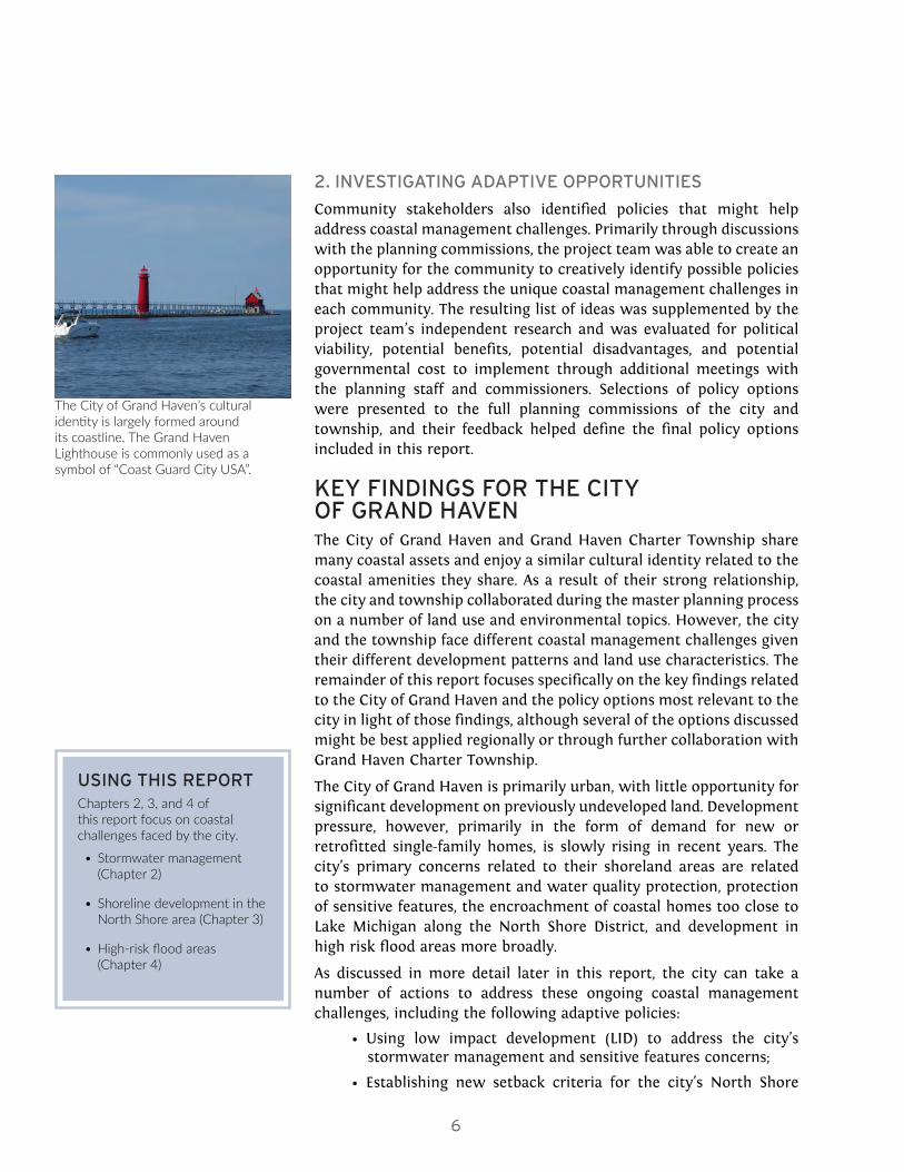
The City of Grand Haven’s cultural identity is largely formed around its coastline. The Grand Haven Lighthouse is commonly used as a symbol of “Coast Guard City USA”.
Intro
du
ction
7
Zoning District to halt residential encroachment toward Lake Michigan; and
• Adopting new building standards and/or risk avoidance policies to minimize flood risk and damage in high risk flood areas, including especially high risk Great Lakes coastal areas
These policy recommendations address the broader coastal challenges identified by the city stakeholders and provide a framework from which the City of Grand Haven can begin developing tailored resiliency tools to confront their primary coastal concerns. In this report, each coastal management challenge is addressed through the lens of these policy recommendations – from which we present different intensities of adaptive policy options specific to the city’s land use characteristics. An important finding of this project to note here is that coastal management challenges often implicate more than just planning staffs and planning commissions. As such, the adaptive policy options presented in this report highlight the necessity for interdepartmental collaboration.
THE GRAND HAVEN COMMUNITY’S COASTAL ASSETS AND CHALLENGESThe City of Grand Haven enjoys a number of coastal assets – both natural and manmade.
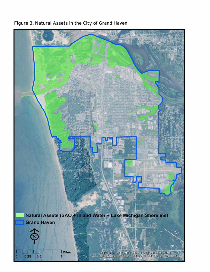
The natural assets include State of Michigan designated Critical Dune Areas, public access to healthy beaches – including Grand Haven State Park, and a number of unique viewsheds of Lake Michigan. The city’s some 600 acres of state-designated Critical Dune Areas provide unique habitats for rare and endangered species, offer enormous recreational value, and are an important coastal flood buffer. Furthermore, the city’s 270 acres of wetlands are also critical flood-management resources that provide habitats to a number of Michigan’s sensitive wildlife populations.
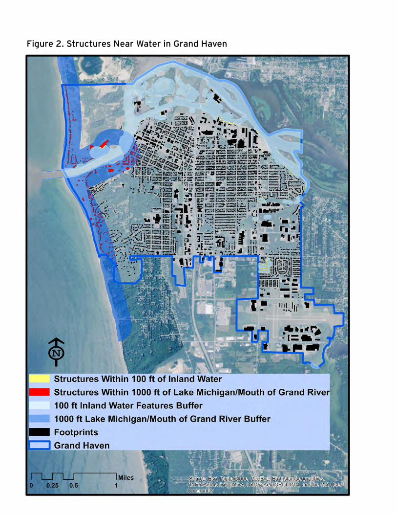
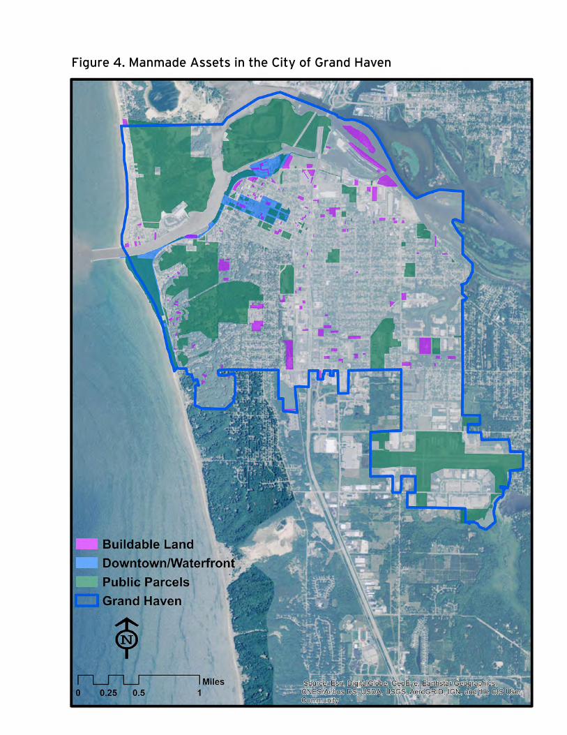
Additionally, a thoughtfully developed built environment affords the City of Grand Haven a walkable downtown and a plethora of public spaces and tourist attractions. As illustrated by Figure 2, the city has nearly 500 buildings (about 7% of total city structures)—primarily homes—within 1,000 feet of Lake Michigan and the mouth of the Grand River. It also has an additional 101 buildings (1.5% of total city structures) within 100 feet of inland bodies of water, including upland portions of the Grand River. In total, 8.5% of the city’s structures are near water.
Strong leadership regarding the stewardship of these natural and manmade assets make the City of Grand Haven a highly desirable place not only to live and do business, but also to recreate and sightsee. Over time, these assets have also shaped the city’s identity and economy. Figures 3 and 4 show that areas with natural assets
The policy options identified in this report are designed to help the Grand Haven community adapt, or adjust to new conditions, such as changing water levels and extreme coastal storms.
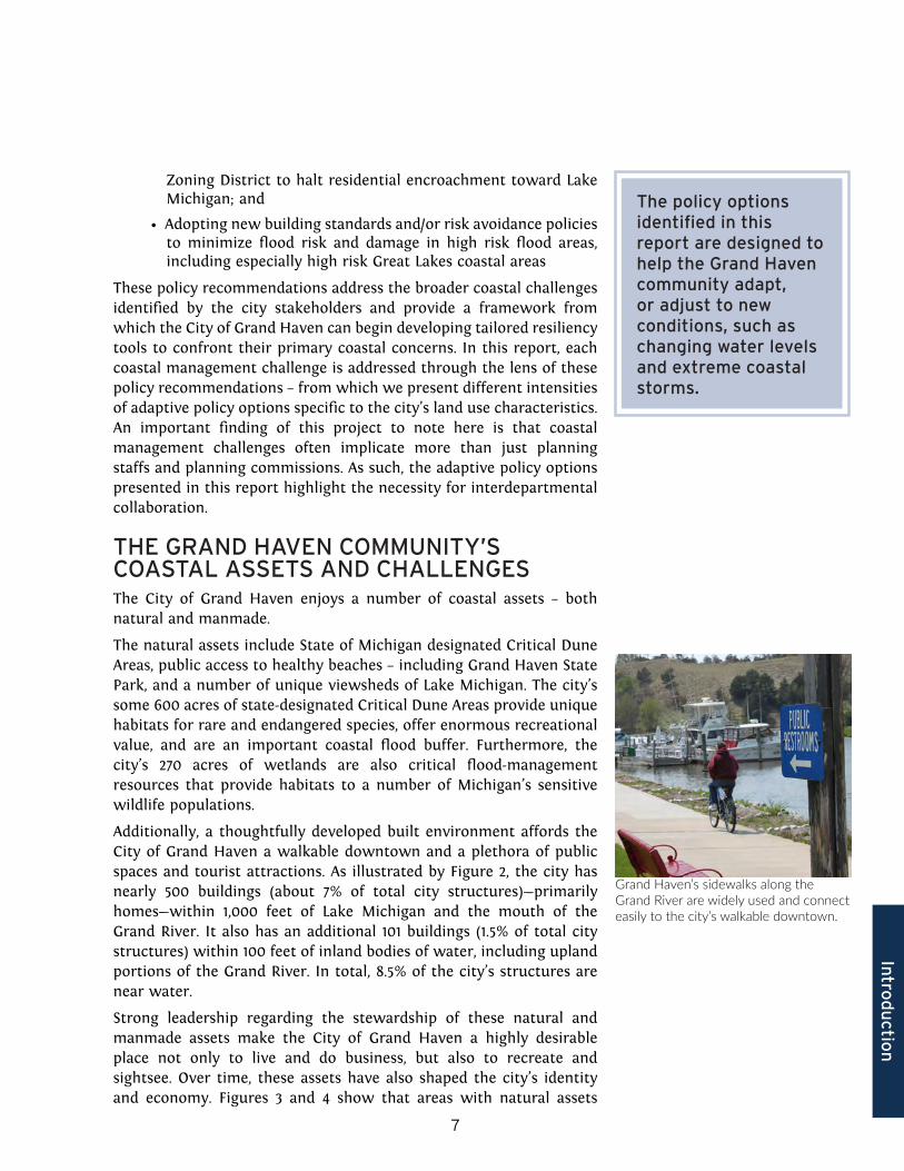
Grand Haven’s sidewalks along the Grand River are widely used and connect easily to the city’s walkable downtown.
8
Figure 2. Structures Near Water in Grand Haven
Intro
du
ction
9
overlap with areas of manmade assets. In other words, the amenities local stakeholders identify as most important to the city’s cultural identity are also places with unique natural landscapes. However, this also means that development interests can create conflicts between the economic benefits of allowing development in natural areas and the environmental and social needs to preserve natural features. In fact, many of the dune areas in the City of Grand Haven have already been developed and a number of the city’s wetlands have been filled for development. It also appears that shoreline development has been slowly encroaching on Lake Michigan, and many areas of impervious surface (e.g., parking lots, roads, buildings) are generating stormwater runoff that can negatively impact water quality and damage sensitive natural features.
Our analysis demonstrates that the City of Grand Haven has already taken a number of steps that are commonly recommended as good steps to take in order to become a more resilient community. Even so, the city could do more. Through consultation early in this project, and building on the city’s recent efforts to update its master plan, community stakeholders identified several coastal management challenges of particular interest for further consideration, including the following:
1. The need for improved stormwater management throughout the community;
2. Declining health of sensitive habitats;
3. The encroachment of shoreline development along Lake Michigan in the North Shore Zoning District; and
4. Potential development vulnerabilities in other high-risk flood areas.
For this study and report, we have consolidated these issues into three broad topical areas: stormwater management, high-risk near-shore coastal development, and high-risk flood hazard areas (i.e., folding sensitive habitats into these topics where appropriate). For each of these topics, we provide a brief analysis of the importance of the topic and a range of policy options the city might adopt. Following these coastal challenges, we conclude the report with several overarching recommendations the city might also adopt as it works to become an even more resilient Great Lakes coastal community.
COASTAL CHALLENGESCommunity stakeholders identified several challenges related to coastal management in the City of Grand Haven including the following:
• The need for improved stormwater management throughout the community
• Declining health of sensitive habitats
• Encroachment of shoreline development along Lake Michigan in the North Shore Zoning District
• Potential development vulnerabilities in other high-risk flood areas
10
Figure 3. Natural Assets in the City of Grand Haven
11
Figure 4. Manmade Assets in the City of Grand Haven

12
POLICY OPTIONS PRESENTED IN THIS REPORT
There are a number of potential adaptive actions that the City of Grand Haven can implement either through infrastructure policy or through revisions to its zoning code and/or other ordinances to address the coastal challenges of interest to the community. For each of these challenges, we discuss briefly the nature of the challenge and then present an array of policy options, generally ranging from option level “0” (activities the city is already undertaking or will need to undertake soon in response to changes in federal and state law) up to option level “3” (more intensive options in terms of both effort required to implement and the potential for enhanced resiliency).
It is worth noting here that all of the options presented in this report represent opportunities for the City of Grand Haven to become a more resilient community in tangible ways, but all also present some additional ‘costs’ or disadvantages. Most notably, all will require additional administrative costs in terms of time and effort required by city staff and citizen committees, to a greater or lesser extent. All also pose the potential of creating some political pushback by residents who either do not see the benefits of these added efforts, or resist options that might entail additional limits on the use of private property, or both. Because these potential disadvantages are relatively uniform across all of the policy options discussed in Chapters 2 through 4, they are not repeated for each option individually.
POLICY OPTIONSEach chapter identifies a number of policy options organized into levels.
• Level 0 - These include activities the city is already undertaking or will need to undertake soon by law.
• Level 1-3 - The remaining policy options range from least intensive in terms of effort and effectiveness (level 1) to more intensive (level 3).
Intro
du
ction
13
14
2Stormwater Management
15
Sto
rmw
ater
STORMWATER MANAGEMENTThe City of Grand Haven already requires development to comply with regulations found in its Stormwater Design and Management Ordinance (henceforth referred to as “stormwater ordinance”). The regulations surrounding stormwater in the city might be strengthened through the increased use of low impact development (LID) to protect water quality and sensitive natural features from damaging runoff.
According to the Southeast Michigan Council of Government, LID is “[T]he cornerstone of stormwater management. LID uses the basic principle that is modeled after nature: manage rainfall where it lands.”1 It is predicated on “design techniques that infiltrate, filter, store, evaporate, and detain runoff close to its source…. They [LID practices] can be integrated into the existing infrastructure.”2 There are a number of LID best management practices, both structural and non-structural, that can yield more than one beneficial outcome post-implementation (i.e., improved water quality and preservation of natural vegetation). Consequently, implementing LID policies can also lead to improved protection and health of sensitive habitats in the City of Grand Haven, and potentially reduce imprudent build-out in high-risk flood areas.
Structural best management practices include, for example, bioretention areas (rain gardens), capture reuse structures (rain barrels), and detention basins (dry or wet ponds). Some non-structural best management practices include, for example, stormwater disconnection (directing stormwater runoff to areas of existing vegetation), riparian buffer areas, sensitive areas zoning overlay, and reduction in impervious surfaces.3
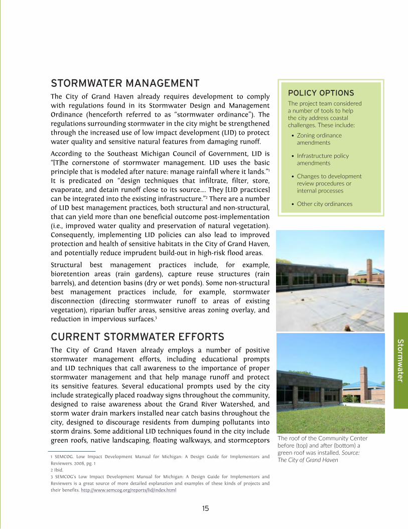
CURRENT STORMWATER EFFORTSThe City of Grand Haven already employs a number of positive stormwater management efforts, including educational prompts and LID techniques that call awareness to the importance of proper stormwater management and that help manage runoff and protect its sensitive features. Several educational prompts used by the city include strategically placed roadway signs throughout the community, designed to raise awareness about the Grand River Watershed, and storm water drain markers installed near catch basins throughout the city, designed to discourage residents from dumping pollutants into storm drains. Some additional LID techniques found in the city include green roofs, native landscaping, floating walkways, and stormceptors
1 SEMCOG. Low Impact Development Manual for Michigan: A Design Guide for Implementors and Reviewers. 2008, pg. 12 Ibid.3 SEMCOG’s Low Impact Development Manual for Michigan: A Design Guide for Implementors and Reviewers is a great source of more detailed explanation and examples of these kinds of projects and their benefits. http://www.semcog.org/reports/lid/index.html
POLICY OPTIONSThe project team considered a number of tools to help the city address coastal challenges. These include:
• Zoning ordinance amendments
• Infrastructure policy amendments
• Changes to development review procedures or internal processes
• Other city ordinances
The roof of the Community Center before (top) and after (bottom) a green roof was installed. Source: The City of Grand Haven

16
placed in storm drains to remove stormwater pollutants.4
These stormwater efforts help contribute to the health and vibrancy of the City of Grand Haven because they help maintain the natural and manmade assets that make the city an attractive community for residents, tourists, and businesses.
NEW REQUIREMENTS FOR STORMWATERThe City of Grand Haven is being required to make amendments to its current stormwater policies. In response to the U.S. Environmental Protection Agency’s (EPA) updated municipal separate storm sewer systems (MS4) standards to treat polluted stormwater runoff, the Michigan Department of Environmental Quality (MDEQ) has updated its municipal separate storm sewer systems (MS4) program standards to better account for nonpoint source pollution.
The Ottawa County Drain Commission (OCDC) is subject to the minimums set forth by MDEQ’s updated MS4 program, but it can also adopt standards that are more stringent than those established by MDEQ. OCDC has worked with the Macatawa Area Coordinating Council (MACC) to develop standards (OCDC Site Development Rules) in compliance with these updates. In some cases, these standards are more stringent than the MDEQ baseline.
The City of Grand Haven’s stormwater ordinance must comply with the MDEQ MS4 program and OCDC’s new requirements. A review of the city’s stormwater ordinance by the city’s engineering consultant, Abonmarche, concluded that the city must do the following things to come into compliance:
1. Identify sensitive areas and require nonstructural [best management practices] BMPs (Low Impact Design/Development) for those areas
2. Amend its stormwater ordinance to include new language regarding:
a. Pretreatment
b. Hot spots
c. Cold water streams
The first of these requirements is significant for the city because identifying sensitive areas within the community, and requiring nonstructural BMPs for those areas, prompts the city to start introducing LID elements into its land management policies and regulations. Since the City of Grand Haven has to comply with the new requirements, these changes are considered the “Level 0” policy option. Adoption of the Level 0 approach would help not only with stormwater runoff, but would also help protect sensitive areas. Yet, the City of Grand Haven could do more to strengthen stormwater management. The OCDC Site 4 See https://grandhaven.s3.amazonaws.com/pdf_documents/sustainability/low_impact_development_guide.pdf for a list of LID locations within the City of Grand Haven
OTTAWA COUNTY DRAIN COMMISSIONThe Ottawa County Drain Commission (OCDC) does much more than maintain drains. The mission statement of OCDC is to protect surface waters and the environment by providing stormwater management through flood control measures, the development review process, soil erosion control, and water quality measures.
17
Sto
rmw
ater
Development Rules note that they referenced the Southeast Michigan Council of Government’s (SEMCOG’s) Low Impact Development Manual for Michigan as a guide for developing their new Best Management Practices (BMPs) and other standards. Using that same manual as a reference, we have identified several sets of increasingly pro-active stormwater management options the City of Grand Haven might adopt to enhance its stormwater management efforts, beyond merely complying with the OCDC rules, in order to help illustrate and assess those options.
POLICY OPTIONS
LEVEL 0: Update the city’s stormwater ordinance in order to comply with the MDEQ MS4 program and OCDC’s new requirements.
LEVEL 1: Adopt more stringent standards within the city’s stormwater ordinance than Ottawa County Drain Commission (OCDC) requires.
Standards that are not required by the updated OCDC stormwater regulations, but that SEMCOG includes in their manual’s model stormwater ordinance include:
• Planning commission review of stormwater plans submitted by developers.
• This is not something that is listed in state law as a responsibility of the planning commission, but input from the planning commission would be consistent with other local review processes. Additionally, any recommendations for action on the stormwater plan could be part of the recommendation for action on a site plan or subdivision plat.
• Offer development incentives only to those proposed projects that employ BMPs that “enhance the response of a piece of land to a storm event rather than treat the runoff that is generated.”5
• Examples: Minimize soil compaction or soil restoration; protect existing trees; restore or enhance native vegetation and riparian buffers .
Adoption of this approach would have the benefit of further preventing damaging stormwater runoff due to concerted efforts to not only more thoroughly review stormwater plans, but also by incentivizing the enhancement of the natural landscape’s ability to respond to a storm event. A potential challenge to this approach is that it will increase the burden on the city to demonstrate the need for, as well as benefits of, these standards, beyond merely citing the need to come into compliance with state and county rules.
5 SEMCOG. Low Impact Development Manual for Michigan: A Design Guide for Implementors and Reviewers. 2008, pg. 486
LOW IMPACT DEVELOPMENTLow Impact Development is an approach to stormwater management that manages stormwater at its source. Traditional approaches aim to divert stormwater into sewers and drainage systems as quickly as possible. Low Impact Development is an important tool for increasing community resiliency as it reduces toxins in the water, prevents erosion, and can create beautiful public spaces in the process.
18
LEVEL 2: Develop a more coordinated effort between the planning commission and public works department to advocate for and enable LID within the City of Grand Haven.
Ways to develop a more coordinated effort might include:
• Establishing standing meetings between the planning, public works, building inspection, and other city staff as appropriate
• Enabling LID in zoning regulations:
• Examples: Integrating LID elements into off-street parking landscaping zoning regulations; allowing for shared parking/driveways in residential districts .
• Incentivizing private property owners to use low impact development on their land:
• Examples: Introducing a recognition program for sites employing LID/creative stormwater management; accelerate plan review for site plans implementing
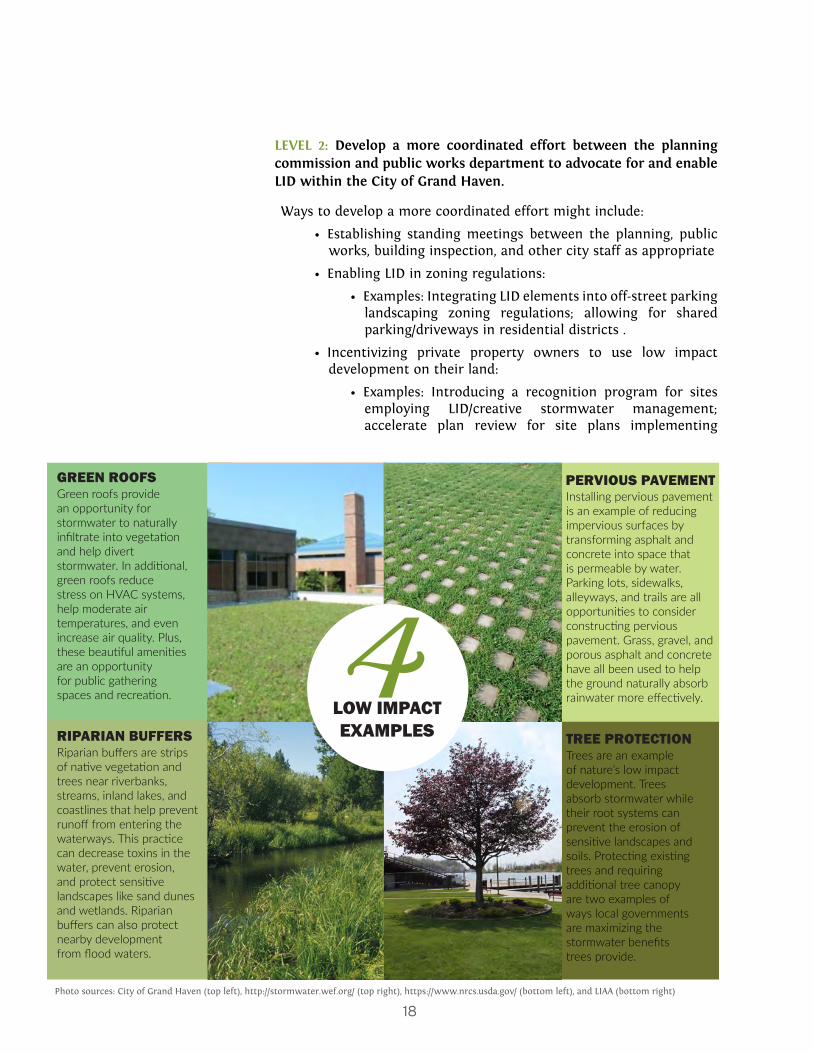
TREE PROTECTIONTrees are an example of nature’s low impact development. Trees absorb stormwater while their root systems can prevent the erosion of sensitive landscapes and soils. Protecting existing trees and requiring additional tree canopy are two examples of ways local governments are maximizing the stormwater benefits trees provide.
RIPARIAN BUFFERSRiparian buffers are strips of native vegetation and trees near riverbanks, streams, inland lakes, and coastlines that help prevent runoff from entering the waterways. This practice can decrease toxins in the water, prevent erosion, and protect sensitive landscapes like sand dunes and wetlands. Riparian buffers can also protect nearby development from flood waters.
GREEN ROOFSGreen roofs provide an opportunity for stormwater to naturally infiltrate into vegetation and help divert stormwater. In additional, green roofs reduce stress on HVAC systems, help moderate air temperatures, and even increase air quality. Plus, these beautiful amenities are an opportunity for public gathering spaces and recreation.
PERVIOUS PAVEMENT
LOW IMPACT EXAMPLES
4
Installing pervious pavement is an example of reducing impervious surfaces by transforming asphalt and concrete into space that is permeable by water. Parking lots, sidewalks, alleyways, and trails are all opportunities to consider constructing pervious pavement. Grass, gravel, and porous asphalt and concrete have all been used to help the ground naturally absorb rainwater more effectively.
Photo sources: City of Grand Haven (top left), http://stormwater.wef.org/ (top right), https://www.nrcs.usda.gov/ (bottom left), and LIAA (bottom right)

19
Sto
rmw
ater
LID techniques; reducing fees charged to the applicant (e.g. plan review fees) for site plans implementing LID techniques.
If this approach were adopted by the city, some of the benefits might include: a unified message that LID efforts are positive and obtainable stormwater management goals; encouraged community participation in LID efforts driven by incentive programs; and a tailored implementation approach that could fit with its current development and stormwater infrastructure. In addition, enabling LID techniques in the city’s zoning regulations would allow for the city to reduce their high levels of impervious surfaces, and in return decrease the potential for damaging stormwater runoff. There are challenges, however, that the city might confront while attempting to adopt this approach, including the burden of additional standing meetings and the need to develop and administer a communication process and incentives program that effectively encourages community participation.
LEVEL 3: Develop a stormwater utility program.
A stormwater utility program is used by many cities across the United States, including Ann Arbor, MI. It offers a legally permissible way for municipalities to assess stormwater fees on residents and business owners proportional to the necessary costs of service. In order for the program to be legally permissible in the State of Michigan, the fees must serve a regulatory and not a revenue-generating purpose, and property owners must also be able to refuse or limit their use of service (e.g., by reducing impervious area on their property). As an example, Ann Arbor achieves these criteria by using the program to fulfill National Pollutant Discharge Elimination System (NPDES) and National Flood Insurance Program (NFIP) obligations, and by allowing
ENABLING LOW IMPACT DEVELOPMENT IN THE CITY’S ZONING ORDINANCE
The Level 2 approach to improving stormwater management in the City of Grand Haven includes enabling Low Impact Development in the City of Grand Haven Zoning Ordinance. This box contains two examples of ordinance amendment language that could help the City require and/or allow for additional Low Impact Development.
Example 1: Integrate LID elements into Off-Street Parking Landscaping regulations (integrate into Chapter 40; Article VIII; Sec. 40-803):Example Language: Require that landscaped areas be sufficiently
large to provide stormwater management. Allow for depressed parking islands that can include curb cuts to allow stormwater into the islands. For example, the following sentences could be added if the community requires protective curbs around landscaping. “Curbs separating landscaped areas from parking areas may allow stormwater runoff to pass through them. Curbs may be perforated or have gaps or breaks.”
Example 2: Allow for shared parking/driveways in residential districts (integrate into Chapter 40; Article VI; Sec. 40-606)
20
owners to reduce their imperviousness in order to reduce their use of service fees (which are directly proportionate to their imperviousness). 6
Although the development of a stormwater utility presents many challenges, including the initiation of the program, establishing guidelines, and the development of oversight procedures, there are corresponding benefits. Most notably, it could provide incentives and encourage otherwise residents and business owners to participate in using LID techniques (e.g., rain barrels, green roofs, and pervious pavers). It also has the potential to help defray the costs of improving and maintaining stormwater management practices and systems, even though it would not be revenue generating. Creating a utility might be especially useful if the city works to fully integrate the various options presented in this report, as recommended and discussed in the conclusion of this report (see Chapter 5).
6 MML (Michigan Municipal League). Michigan Green Communities: Ann Arbor Stormwater Utility Case Study. http://www.mml.org/green/pdf/MGC_A2_StormwaterUtility_Case.pdf
Stormwater utilities are also discussed in Chapter 4 as a method to fund improvements that would reduce flood severity.

21
Sto
rmw
ater

22
3Shoreline Development in the North Shore District

23
No
rth S
ho
re D
istrict
LAKE MICHIGAN SHORELINE DEVELOPMENT IN THE NORTH SHORE AREAThe city could address encroaching shoreline development along Lake Michigan in the North Shore District by amending its zoning ordinance to halt imprudent shoreline development. There are a number of different ways to approach developing new zoning policy. As an example, the City of St. Joseph, MI recently adopted a zoning code amendment to establish an overlay district (Edgewater Overlay District) that restricts development lakeward of an affixed line representing the most landward edge of the overlay district (See Appendix A). In effect, St. Joseph’s Edgewater Overlay District operates like a buffer or setback from Lake Michigan. The benefit of adopting a new zoning district where no structures currently sit is that St. Joseph can manage development without having to revisit other portions of its zoning ordinance, like nonconforming use provisions, and it can specify all of the relevant provisions for that district within that section of the code itself. The City of Grand Haven could similarly decide to adopt something like St. Joseph’s ordinance, or it could adjust the setback line that already exists in the North Shore District landward to increase protection to properties within that district from exposure to dangerous shoreline dynamics.
In general, a setback line marks the furthest point lakeward that development on any given lot can occur. Currently, the city’s North Shore Zoning District permits encroachment up to twenty-five feet from parcel lot lines, and it allows property owners with structures situated landward of neighboring structures to shift their homes lakeward. Under this policy, structures on at least a few parcels are currently exposed to dangerous shoreline dynamics, as discussed more below. Even more structures are likely to become exposed over time as homes are shifted lakeward while erosion continues to move the shoreline landward.
Because the City of Grand Haven already has the North Shore District in place, the remainder of this section explores how the city might modify that district’s waterfront setback with the establishment of a clear, equitable, and protective development setback line based on the physical dynamics of a Great Lakes shore. We also discuss how the city might incorporate policies designed to prevent new, inappropriate development lakeward of that setback line, or to ensure removal and cleanup of structures already lakeward of that line should they be damaged by a coastal storm.
SETBACKSCurrently, new houses or large redevelopments of homes in the city’s North Shore Area must follow a setback requirement from the lot line nearest Lake Michigan. Homes must be set back at least 25 feet from the parcel lot line, and can be no nearer to the lot line than the average distance of each neighboring home. Over time, this regulation will allow for new homes to slowly creep closer to Lake Michigan and closer to dangerous coastal dynamics.
In this picture from summer 2016, homes look far from danger. However, water levels can quickly change. The analysis in this chapter shows that homes along the city’s North Shore may experience damage due to strong waves and flooding from Lake Michigan.

24
NORTH SHORE ZONING DISTRICTStructures situated in the city’s North Shore Zoning District are exposed to shoreland hazards like coastal flooding, beach erosion, and high-energy waves because of their proximity to Lake Michigan and its dynamic coast.
Figure 5 displays high-risk coastal hazards zones under low-risk (lucky), moderate-risk (expected) and high-risk (perfect storm) combinations of standing lake water levels and storminess for the city’s North Shore District. Initial climate futures were developed for the 2016 Grand Haven Master Plan. For this project, we updated and remapped these high-risk zones. (See the one-page box below to review the framework from which we designed these climate futures, and the reasons we have remapped the high-risk zones.)
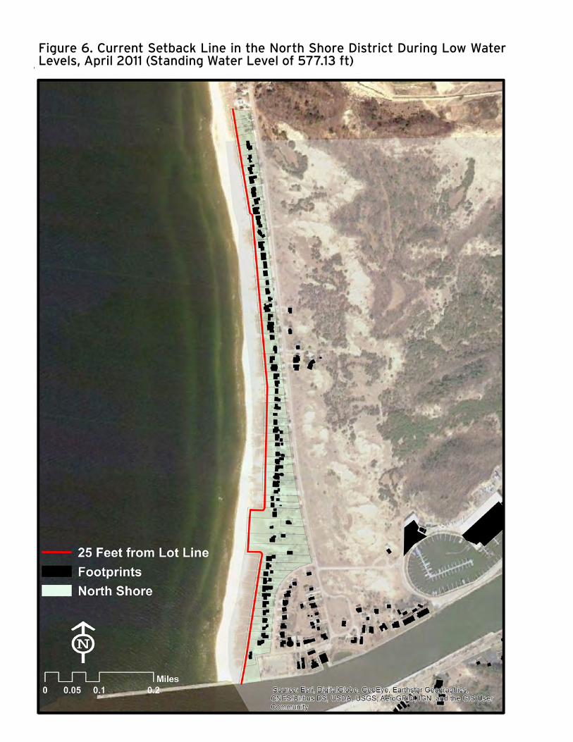
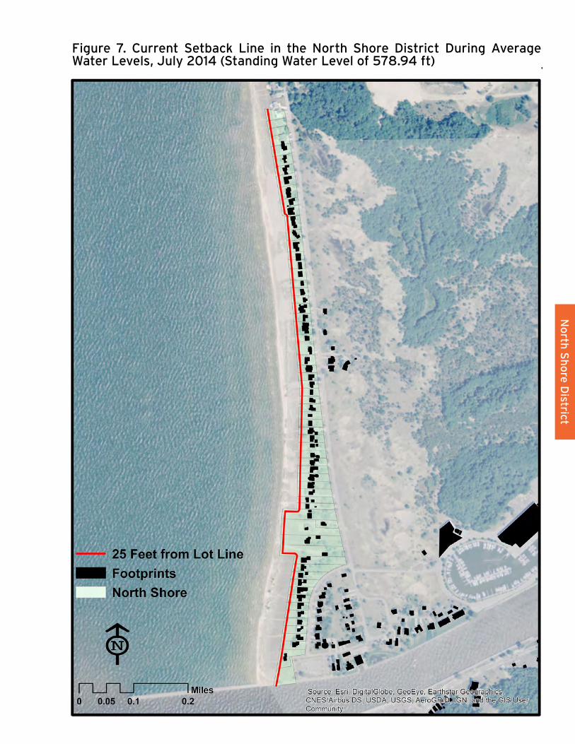
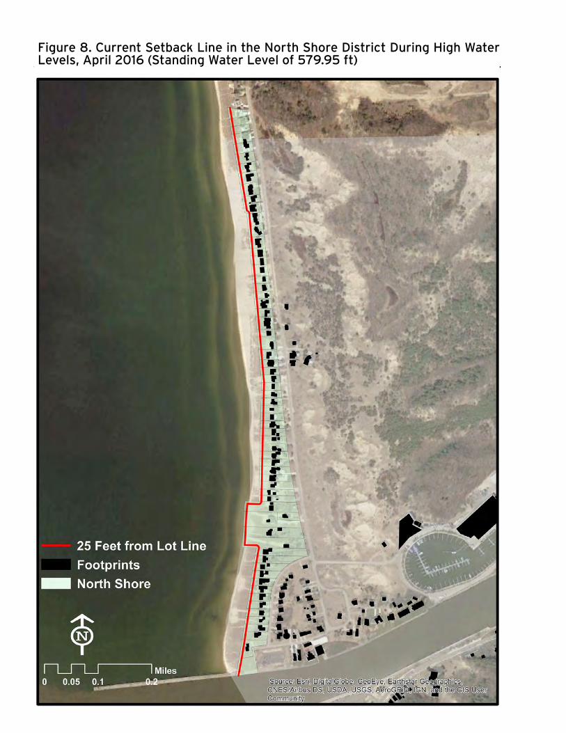
Figures 6, 7, and 8 show historic aerial images of the North Shore under varying standing water conditions with the current setback line mapped along the shoreline. It is clear from these maps that, given the lakeward extent of some parcels, new or redeveloped structures could move much closer to Lake Michigan. In fact, we estimate that only three of the 70 structures located on the North Shore are abutting the current setback line. This means that a majority of property owners could feasibly continue moving structures closer to Lake Michigan, which would increase their exposure to potentially damaging shoreline dynamics like high-energy waves during coastal storms and increased risk of inundation especially during periods of high standing water levels.
POLICY OPTIONSThe City of Grand Haven might consider several approaches to adjusting the waterfront setback within the North Shore District to ensure greater protection from shoreline dynamics. We have developed four such approaches to illustrate how the city might establish and periodically adjust that setback, three of which explicitly tie it to natural shoreline dynamics, including the following:
APPROACH 1: Fix all development in its current location (i.e., retain the 25 foot setback but disallow any additional shifting of current structures lakeward under current setback averaging provisions). It is not clear how this approach would be adjusted over time.
APPROACH 2: Adopt a setback premised on setting structures landward of the anticipated distance of shoreline erosion for two generations of a house (i.e., where one generation equals 30 years, the life of a typical mortgage, and two generations equals 60 years). The city might specify that this setback be adjusted periodically, such as every 10 or 15 years, to account for changes in the shoreline.
Structures in the city’s North Shore Zoning District are exposed to shoreland hazards like coastal flooding, beach erosion, and high-energy waves.
The policy approaches listed in this chapter include several alternatives to the existing setback regulation in the North Shore District.

25
No
rth S
ho
re D
istrict
25
Figure 5. Updated extent of potential flooding and/or high-energy waves under “Lucky,” “Expected,” and “Perfect Storm” climate future conditions for the City of Grand Haven North Shore district.

26
RESEARCH METHODS: SCENARIO PLANNING AND CLIMATE FUTURES
Scenario PlanningDuring the master planning work completed for the City of Grand Haven and Grand Haven Charter Township in 2016, we relied on a useful planning framework called “scenario planning” to help envision plausible narratives for the future conditions of the two communities, given the many uncertainties about what the future might look like.
Uncertainty in a planning setting is common, particularly when the planning issues are rooted in natural environmental processes, like water level fluctuations on the Great Lakes. Scenario planning helps navigate these uncertainties because it allows for adaptive planning by plotting different, but reasonable future narratives against each other.
These narratives about uncertain futures help communities test policies, prioritize strategies, and demonstrate potential future conditions.1 This gives communities a way to process the future in the present.2 Unlike a forecast, which concretely lays out a predicted future for a community, scenario planning arranges a palate of reasonable, potential futures from which decisions regarding uncertainties can be made and planned for by a community.
Climate Futures3
Developing our scenario planning framework required establishing assumptions regarding future climate conditions that could affect the Grand Haven community. We first developed three scientifically reasonable climate futures, entitled “Lucky,” “Expected,” and “Perfect Storm,” to accomplish this. The key assumptions underlying each of these climate futures included the following:
1 Holway, J., Gabbe, C. J., Hebbert, F., Lally, S., Mathews, R., Quay, R., & Policy, L. I. of L. (2012). Opening access to scenario planning tools. Policy Focus Report (p. 56). Retrieved from https://www.lincolninst.edu/pubs/2027_Opening-Access-to-ScenarioPlanning-Tools 2 Harwood, S. A. (2007). Using Scenarios to Build Planning Capacity. In L. D. Hopkins & M. Zapata (Authors), Engaging the future: Forecasts, scenarios, plans, and projects (pp. 135-154). Cambridge, MA: Lincoln Institute of Land Policy. 3 The City of Grand Haven 2016 Master Plan provides a more thorough explanation of our research methods on Page 66. http://www.grandhaven.org/2016-grand-haven-master-plan/
• Lucky – Great Lakes water levels will continue to stay relatively low. Although there will be wave and wind action, major storm events and wave impacts will not affect properties landward of current beaches. Other climactic conditions (e.g., storm frequency and intensity, heat waves) will remain consistent with patterns in recent history.
• Expected – Great Lakes water levels will continue to fluctuate according to long-term decadal patterns, including recent extreme storm events. There will be periods of high Great Lakes standing water levels similar to the long-term highs recorded in 1986, but levels under this climate future are set at the long-term average. Large storm events will also occur more frequently. During these high water periods, a “100-year” storm event will create waves that wash up onto coastal properties, with areas subject to damaging wave action and inundation.
• Perfect Storm – Great Lakes water levels will continue to fluctuate according to long-terms decadal patterns, consistent with assumptions made for the Expected climate future. As distinguished from the ‘expected’ climate future, Great Lakes standing water levels are set higher than the long-term average and closer to the long-term high under the ‘perfect storm’ climate future. In addition, because of increased frequency and intensity of storms, a “500-year” storm event will become more common, essentially becoming the “100-year” storm event (i.e., much more likely to occur). During such a storm event, waves will wash up onto coastal properties, with areas subject to damaging wave action and inundation.
27
No
rth S
ho
re D
istrict
MAPPING CLIMATE FUTURESHaving established the parameters of a range of reasonable climate futures, the next step was to map the spatial extent of shorelands subject to inundation and wave action along Great Lakes shores, along with riverine areas influenced by lake water levels, corresponding to each climate future. Detailed maps and analyses of potential impacts to land areas and structures were incorporated into the 2016 Master Plan. We similarly incorporate these climate futures and corresponding analysis into this report.
It is important to note that our initial mapping of these climate futures during the master planning process relied on proposed FEMA-generated estimates of wave run-up from storms along Great Lakes shores and their corresponding spatial extents. Since the 2016 Master Plan has been formally adopted, however, FEMA has withdrawn these estimates due to concerns that there might be errors in their methodology. They are reworking their estimates and plan to reissue new estimates at some point in the future.
In the meantime, we have developed a new set of climate future maps that rely instead on observed storm-induced wave elevations obtained from gauges in the Great Lakes by coastal engineers at Michigan Technological University. These new maps show a reduced spatial extent for the expected and perfect storm climate futures because the observed storm-induced wave elevations used to remap these climate futures were lower than the numbers previously generated by FEMA. This also resulted in a reduction in the numbers of estimated structures at risk under the expected and perfect storm climate futures, although not as significant as the land area involved. Pending the reissuance of FEMA-generated estimates, it is not necessary for the city to amend its 2016 Master Plan. Nonetheless, we employ our revised estimates for the purposes of this study and report.
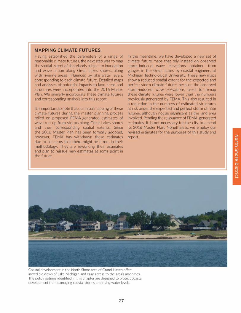
Coastal development in the North Shore area of Grand Haven offers incredible views of Lake Michigan and easy access to the area’s amenities. The policy options identified in this chapter are designed to protect coastal development from damaging coastal storms and rising water levels.
28
Figure 6. Current Setback Line in the North Shore District During Low Water Levels, April 2011 (Standing Water Level of 577.13 ft)
29
No
rth S
ho
re D
istrict
29
Figure 7. Current Setback Line in the North Shore District During Average Water Levels, July 2014 (Standing Water Level of 578.94 ft)
30
Figure 8. Current Setback Line in the North Shore District During High Water Levels, April 2016 (Standing Water Level of 579.95 ft)

31
No
rth S
ho
re D
istrict
APPROACH 3: Adopt a setback that follows the ‘Perfect Storm’ high-risk hazard area, which represents the predicted landward extent along the shoreline of inundation and/or wash-over by high-energy waves during an extreme coastal storm event that occurs while Lake Michigan is at or near an all-time high standing water level. As with Approach 2, the city might specify that this setback be adjusted periodically, such as every 10 or 15 years, to account for changes in the shoreline.
APPROACH 4: Establish a setback line that reflects an integration of Approaches 2 and 3 (e.g., incorporating and smoothing out the most landward edge of the two lines taken together).
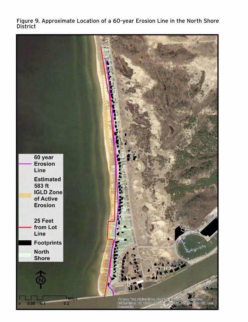
Figure 9 illustrates the estimated location of a two-generation erosion setback line under high standing water conditions, and Figure 10 illustrates the Perfect Storm high-risk hazard line under average standing water conditions. Approximately 23 of the 70 total properties on the North Shore either abut or are lakeward of the estimated two-generation erosion setback line, while approximately 16 properties either abut or are lakeward of the Perfect Storm hazard line. As such, either line represents a more stringent, and more protective, setback option than what the City of Grand Haven currently is using for its North Shore properties.
As noted, adjusting the setback line would benefit the City of Grand Haven because it would limit the lakeward encroachment of development, thus protecting properties from increased exposure to dangerous shoreline dynamics. An additional benefit of adopting the two-generation erosion line, the Perfect Storm hazard line, or some integration of the two, would be that the setback itself and corresponding restrictions would be grounded in reasonable and appropriate technical methodologies for determining the spatial reach of erosion and flood risk, rather than being arbitrarily established.
There would also be challenges for the City of Grand Haven, however. Chief among these would be that the final setback line ultimately employed might be difficult to apply on the ground, depending on the technical assumptions and analyses required. In addition, if the city adjusts the North Shore setback, it would also likely have to amend the zoning code’s nonconforming use regulations, depending on the specific policies it decides to implement along with the new setback (as discussed below). These changes would need to be made simultaneously with the amended setback, especially because multiple structures currently existing within the district would likely become “nonconforming” immediately upon establishment of the new setback.
In addition to adjusting the North Shore District waterfront setback landward, the city also has multiple options for adopting policies tied
EROSION RISKThere are currently 70 structures along the North Shore. Approximately 23 abut or are lakeward of the estimated two-generation erosion line shown in Figure 9. These homes may be impacted by erosion in the next 60 years.
Amending the rear lot setback in the North Shore Zoning District would not impact existing structures unless the an event occurs that would necessitate the home be rebuilt or the property owners would seek to expand the property’s footprint.
32
Figure 9. Approximate Location of a 60-year Erosion Line in the North Shore District

33
No
rth S
ho
re D
istrict
33
Figure 10. Approximate Location of a Perfect Storm High-hazard Line in the North Shore District

34
to that setback. As with establishment of the setback line itself, the associated policy options do not follow the level option framework employed elsewhere in this report because the options are not mutually exclusive; the city might incorporate two or more of them simultaneously. Each of the options speak to various aspects of risk and fairness (i.e., fairness to both individual property owners and the larger community) in terms of allowing development while not putting people and structures in harm’s way, as well as ensuring the adequate cleanup of structures once damaged.
The ideas of risk and fairness (as well as effectiveness) are subjective measures that, depending on a given policy option considered, can elicit strongly varying opinions from stakeholders on the very meanings of those concepts themselves, especially as applied to the policy option in question. The options presented here provide an array of potential policy approaches the City of Grand Haven might take to manage shoreline development encroaching on Lake Michigan in its North Shore Zoning District so as to prevent new structures from being situated in harm’s way and to facilitate restoration of the natural functioning of the shoreline should existing structures be severely damaged by a storm. Not all of these options might be considered to be appropriate, fair, or effective by all of the community’s stakeholders. Acknowledging that, the policy options we have developed for the city’s consideration include the following:
1. Prohibit the placement of any new structure lakeward of the setback line.
2. Allow only readily movable structures lakeward of the setback line (e.g., following standards regarding ‘readily movable’ like Michigan’s standards for structures within state-designated high-risk erosion areas).
3. Establish that existing structures currently lakeward of the setback line (or structures that become lakeward of that line as the shoreline erodes over time) are nonconforming structures, such that they must be removed if substantially damaged by a coastal storm event.
4. Require that owners of structures currently lakeward of the setback line (or that become lakeward) post a surety bond or obtain homeowner’s insurance sufficient to cover the costs of cleaning up and restoring the shoreline should the structure need to be removed following a coastal storm event (e.g., similar to bond requirements typically required to ensure the cleanup of project sites after construction, or homeowner’s insurance required for properties located within floodplains under the National Flood Insurance Program).
SETBACK REQUIREMENTSEach policy approach identified in this chapter involves the use of a setback line. The list to the right identifies several policy options that could apply to any setback line the city might adopt along the lot lines nearest to Lake Michigan.
The setback policy options outlined in this chapter apply most readily to the North Shore Zoning District. The same setback may not be effective in other areas of the city, such as south of the Grand Haven State Park where elevations are much higher.

35
No
rth S
ho
re D
istrict
INCORPORATING A DYNAMIC, SHORELINE-BASED SETBACK INTO THE CITY’S ZONING ORDINANCE FOR THE NORTH SHORE DISTRICT
The Lake Michigan shoreline changes most dramatically in response to changing standing water levels, which can rise and fall by as much as six feet over a decade. When standing water levels are high, Great Lakes shoreline can erode away quickly. When water levels are low, waves can push sand onto the beach that appears to be accreting, creating the temptation to want to move structures closer to the water. Those beaches erode away quickly again, however, when water levels come back up.
One approach to allowing structures to be built so that residents can enjoy the beach, while simultaneously ensuring that those structures are far enough away from the water to minimize risk, might be to establish and periodically adjust a setback for the North Shore district that is tied to the actual dynamics of the Lake Michigan shoreline, rather than one arbitrary established, and adopt corresponding coastal hazard adaption policies.
To illustrate such an approach, the city might amend its zoning code to incorporate this new setback and to modify corresponding provisions as follows:
• Sec. 40-407.02(C) (site and building placement standards): Separate the rear/waterfront standard to create a freestanding waterfront setback standard. • Require in the ordinance that the appropriate
city agency establish and adjust periodically the setback standard for this district every X (e.g., 10 or 15) years, based on the method deemed most appropriate by the city.
• Declare that structures situated lakeward of the setback in whole or in part, either by
amendment of the code or by movement of the setback line when adjusted, are nonconforming uses subject to Sec. 40-119.04.
• Remove reference to the averaging requirements provided by Sec. 40.306.10.
• Add a new provision mandating that any new structure situated lakeward of the waterfront setback line must be readily movable.
• Add a new provision mandating that any property owner of a lot abutting Lake Michigan must obtain either homeowner’s insurance or a surety bond adequate to cover the reasonably anticipated costs of removing damaged structure(s) and restoring nearshore areas to natural conditions should those structures be damaged to some specified extent (e.g., 60 percent) by a coastal storm (link this to the nonconforming structure provisions below).
• Sec. 40-306.10 (averaging provisions for waterfront lots): Repeal this averaging provision, or remove reference to waterfront lots abutting Lake Michigan so that it applies only to lots abutting the Grand River or other water bodies.
• Sec. 40-119.04 (nonconforming structures): Amend paragraph B, or insert a new paragraph, that provides that when a structure within the NS district is damaged or destroyed to a specified extent or more of its replacement cost (e.g., 60 percent) specifically as a result of inundation or wave action from a coastal storm, that structure must be removed and the area restored to natural conditions, such that no portion of the structure retained or relocated is situated lakeward of the waterfront setback line.
The box below illustrates how the relevant sections to the City of Grand Haven’s current zoning code might be modified to implement these policies.

36
FIGURE 11. UNIVERSITY OF MICHIGAN INTEGRATED ASSESSMENT CENTER WEBINAR POLL, BY PERCENTAGE OF WEBINAR RESPONDENTS.
Which of the following do you think would be
EFFECTIVE?
Which of the following do you think would be FAIR TO PROPERTY
OWNERS?
Which of the following do you think would
be FAIR TO THE COMMUNITY?
Prohibit new structures
73% 59% 82%
Allow movable structures only
33% 52% 23%
Establish nonconforming use provision
44% 65% 57%
Require surety bond
42% 60% 64%
Figure 11 shows the results of a webinar poll conducted by the project team during an Integrated Assessment Center webinar. The poll shows the perceived fairness and effectiveness of policy options related to restricting imprudent shoreline development.
WEBINAR RESULTS
During a webinar hosted by the University of Michigan’s Integrated Assessment Center, the project team queried a number of Great Lakes regional stakeholders (e.g., municipal planners, consultants, academics, and regulatory staff) on their opinions of the potential effectiveness and fairness (for both the property owners and the community) of these potential policy options. Participants were allowed to choose more than one option per question regarding fairness and effectiveness, and the results represent the percent of participants that found each option to be either fair or effective.
Figure 11 shows the results of this small survey. Overall, the only policy that more than a majority of these Great Lakes regional stakeholders thought would be effective would be a prohibition on new structures lakeward of the setback line (73% of the stakeholders who responded), although at least a third thought the other options might be effective to come extent as well. In terms of fairness, at least a majority of the respondents thought that all of the options considered would be fair to either shoreland property owners or the larger community, except that less than a quarter thought that allowing movable structures lakeward of the setback line would be fair to the community, presumably because of the pressure to build shoreline armoring that would come with the presence of those structures (despite being ‘movable’). The option that most respondents thought would be most fair for property owners (65%) would be the designation of structures lakeward of the setback line as nonconforming structures (i.e., relative to the other options considered), while the option that most thought would be fair for the community (82%) would be the prohibition of structures lakeward of the setback line.
“THAT’S NOT FAIR!”Fairness and effectiveness are important, but often subjective, ways to evaluate a policy. The project team asked participants in an Integrated Assessment webinar to identify which policy options seem most effective and most fair to property owners and the community at large.
37
No
rth S
ho
re D
istrict
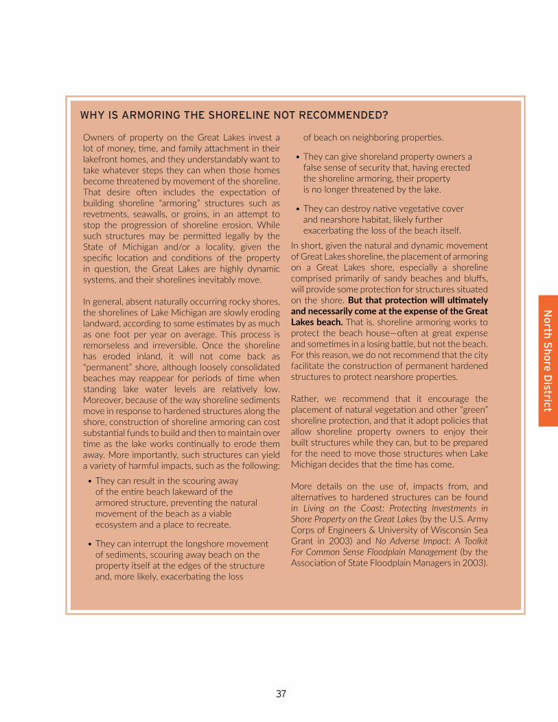
WHY IS ARMORING THE SHORELINE NOT RECOMMENDED?
Owners of property on the Great Lakes invest a lot of money, time, and family attachment in their lakefront homes, and they understandably want to take whatever steps they can when those homes become threatened by movement of the shoreline. That desire often includes the expectation of building shoreline “armoring” structures such as revetments, seawalls, or groins, in an attempt to stop the progression of shoreline erosion. While such structures may be permitted legally by the State of Michigan and/or a locality, given the specific location and conditions of the property in question, the Great Lakes are highly dynamic systems, and their shorelines inevitably move.
In general, absent naturally occurring rocky shores, the shorelines of Lake Michigan are slowly eroding landward, according to some estimates by as much as one foot per year on average. This process is remorseless and irreversible. Once the shoreline has eroded inland, it will not come back as “permanent” shore, although loosely consolidated beaches may reappear for periods of time when standing lake water levels are relatively low. Moreover, because of the way shoreline sediments move in response to hardened structures along the shore, construction of shoreline armoring can cost substantial funds to build and then to maintain over time as the lake works continually to erode them away. More importantly, such structures can yield a variety of harmful impacts, such as the following:
• They can result in the scouring away of the entire beach lakeward of the armored structure, preventing the natural movement of the beach as a viable ecosystem and a place to recreate.
• They can interrupt the longshore movement of sediments, scouring away beach on the property itself at the edges of the structure and, more likely, exacerbating the loss
of beach on neighboring properties.
• They can give shoreland property owners a false sense of security that, having erected the shoreline armoring, their property is no longer threatened by the lake.
• They can destroy native vegetative cover and nearshore habitat, likely further exacerbating the loss of the beach itself.
In short, given the natural and dynamic movement of Great Lakes shoreline, the placement of armoring on a Great Lakes shore, especially a shoreline comprised primarily of sandy beaches and bluffs, will provide some protection for structures situated on the shore. But that protection will ultimately and necessarily come at the expense of the Great Lakes beach. That is, shoreline armoring works to protect the beach house—often at great expense and sometimes in a losing battle, but not the beach. For this reason, we do not recommend that the city facilitate the construction of permanent hardened structures to protect nearshore properties.
Rather, we recommend that it encourage the placement of natural vegetation and other “green” shoreline protection, and that it adopt policies that allow shoreline property owners to enjoy their built structures while they can, but to be prepared for the need to move those structures when Lake Michigan decides that the time has come.
More details on the use of, impacts from, and alternatives to hardened structures can be found in Living on the Coast: Protecting Investments in Shore Property on the Great Lakes (by the U.S. Army Corps of Engineers & University of Wisconsin Sea Grant in 2003) and No Adverse Impact: A Toolkit For Common Sense Floodplain Management (by the Association of State Floodplain Managers in 2003).
38
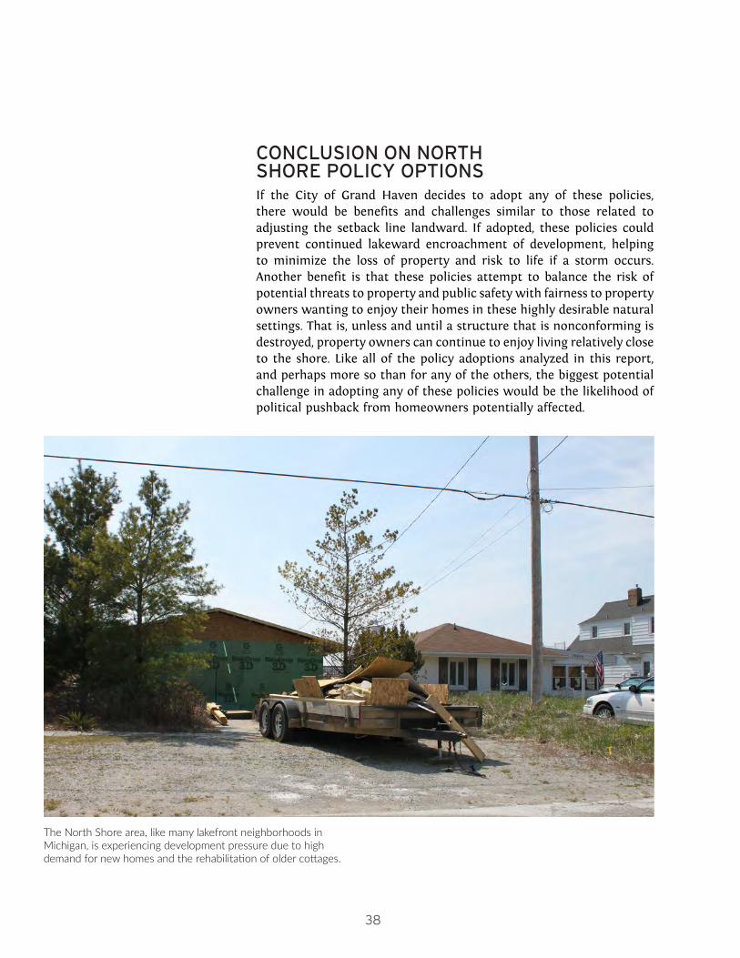
CONCLUSION ON NORTH SHORE POLICY OPTIONSIf the City of Grand Haven decides to adopt any of these policies, there would be benefits and challenges similar to those related to adjusting the setback line landward. If adopted, these policies could prevent continued lakeward encroachment of development, helping to minimize the loss of property and risk to life if a storm occurs. Another benefit is that these policies attempt to balance the risk of potential threats to property and public safety with fairness to property owners wanting to enjoy their homes in these highly desirable natural settings. That is, unless and until a structure that is nonconforming is destroyed, property owners can continue to enjoy living relatively close to the shore. Like all of the policy adoptions analyzed in this report, and perhaps more so than for any of the others, the biggest potential challenge in adopting any of these policies would be the likelihood of political pushback from homeowners potentially affected.
The North Shore area, like many lakefront neighborhoods in Michigan, is experiencing development pressure due to high demand for new homes and the rehabilitation of older cottages.

39
No
rth S
ho
re D
istrict
40
4High-Risk Flooding

41
Hig
h-R
isk Flo
od
ing
HIGH-RISK FLOODING AREA POLICY OPTIONSThere are a number of structures within the city that have been developed within high-risk flood areas. According to our climate futures, we estimate that there are 72 structures at risk under a Lucky climate future, 142 structures at risk under an Expected climate future, and 189 structures at risk under a Perfect Storm climate future.
The City of Grand Haven’s concern about this development in high-risk flood areas could be addressed by adopting new building and/or risk avoidance policies and standards to minimize flood risk and damage in high-risk flood areas. Currently, the city has a floodplain ordinance that implements the minimum requirements necessary for participation in the National Flood Insurance Program (NFIP). This floodplain ordinance provides the city with a foundation from which it could implement more stringent building and/or risk avoidance standards to minimize flood risk and damage in its high-risk flood areas. The level options below describe how the city might consider using its floodplain ordinance to accomplish this.
LEVEL 0: Keep current standards, which represent the minimum needed to implement participation in the NFIP. There is nothing compelling the City of Grand Haven to adopt more stringent standards than the ones they already implement. Structures currently at risk of flooding will continue to be at risk, and new structures can be developed with exposure to similar levels of flooding risk.
LEVELS 1 and 2: Use the No Adverse Impact (NAI) toolkit and the Federal Emergency Management Agency’s (FEMA’s) Community Rating System (CRS) program to develop preventive tools to minimize flood risk and lower insurance premiums. Examples include increasing protection in flood fringe and coastal flooding areas.
The city has a number of preventive tool options to choose from to minimize flood risk, and in the process gain credits with FEMA’s CRS program. When a municipality earns credit in FEMA’s CRS program, it initiates an opportunity to lower flood insurance premiums for residents and businesses within the community’s high-risk flood areas. As such, the City of Grand Haven could both develop more stringent development standards for its high-risk flood areas and also obtain community buy-in because residents could benefit financially from the new, more stringent standards.1
One preventive tool for the City of Grand Haven to consider adoption is tailored local mapping that more clearly defines spatially the land extents of the flood way, flood fringe, coastal hazards, and total 1 See https://www.fema.gov/media-library-data/1444398921661-5a1b30f0f8b60a79fb40cefcaf2bc290/2015_NFIP_Small_Brochure.pdf for an overview of the CRS credit system and ways that local officials can implement preventive tools.
FLOODING RISKFlooding not only causes property damage, but it can also create a burden for residents struggling with mold removal, can lead to respiratory health issues, and can have a lasting impact on the mental health and security of those subjected to recurring flooding. While lakefront flooding tends to put relatively expensive homes at risk, a disproportionately high percentage of lower-income households live in floodplains elsewhere in many communities.
The Community Rating System is a preventative program offered by the National Flood Insurance Program through FEMA.

42
floodplain for the 100-year and 500-year storms. In addition to more clearly defining these areas, the city could remap its high-risk flooding areas to account for hydrologic changes that have resulted from increased imperviousness related to development in the watershed. This progressive approach would help the city better understand how development patterns have changed local hydrology, and in turn help the city structure methods to better combat potential flooding and protect its development at risk. The methods and maps developed by the city for its 2016 Master Plan and for this project represent a good first step toward implementation of this tailored local mapping effort.
Another preventive tool for the City of Grand Haven to consider is enhancing its standards for its flood fringe properties, most specifically those within either its coastal or 0.2% storm flood areas (sometimes referred to as the 500-year storm). An example of an enhanced building standard would be requiring new or redeveloped properties in the coastal or 0.2% storm flood areas (and perhaps other properties within the base or 1% storm flood fringe) to have a first floor that is above the 0.2% storm flood elevation, for added protection. This is more stringent than the city’s current building standard that requires all new or redeveloped properties within its total base floodplain to have a first floor that is just above the base flood elevation (i.e., the 1% storm or 100-year flood elevation).
Figure 12 below illustrates that there are a number of structures that are currently at risk of flooding that are not addressed by the current floodplain standards because they are outside the total base floodplain, but are still at risk within the different high-risk flooding areas: either coastal or 0.2% storm flood areas.
In addition to these preventive tool options, the City of Grand Haven could also consider developing a flood management education
FIGURE 12. NUMBER OF STRUCTURES WITHIN FLOODING AREAS, BY ZONING CLASSIFICATION
RESIDENTIAL STRUCTURES
COMMERCIAL/INDUSTRIAL STRUCTURES
INSTITUTIONAL STRUCTURES
Within the Floodway 2 11 2
Within the Base Flood Fringe 26 30 1
Within the Total Base Floodplain
28 41 3
Within the Additional High-Risk Coastal 0.2% Storm Area (Perfect Storm)
85 outside of Total Base Floodplain
19 outside of Total Base Floodplain
12 outside of Total Base Floodplain
STRUCTURES AT RISKFigure 12 shows that there are a number of structures at risk for flooding not addressed by the current floodplain standards.
Impervious surfaces, such as large parking lots, can contribute to flooding as water is not able to naturally percolate into the ground. The Low Impact Development strategies included in Chapter 2 can also help mitigate flooding.

43
Hig
h-R
isk Flo
od
ing
program and/or revise its Sensitive Areas Overlay (SAO) District to include the entire land area encompassed within its coastal hazards and 0.2% storm flood areas. The city could also consider creating a coastal flooding district. All of these approaches would necessitate undertaking the tailored mapping program described above.
The main benefit of implementing any of these preventive tools is adding further protection to minimize flood risk and prevent building damage. An additional benefit, if the city chose to also join the CRS program, would be that residents within the city’s high-risk flood areas could reduce their flood insurance premiums. Challenges that the City of Grand Haven could encounter if it decides to implement any of these preventive tools, include: the initial cost of investigating and mapping revised high-risk flood areas; potential challenges to the city’s designations of high-risk flood areas; and the added efforts that will be required to demonstrate the benefits of and need for adding more stringent regulations to its floodplain ordinance.
LEVEL 3: Adopt a stormwater utility to help pay for the administration of a more stringent floodplain management ordinance
This level option is the most stringent level option provided to the City of Grand Haven to address its stormwater management concerns. As such, the benefits and challenges are the same as previously discussed. Although the development of a stormwater utility presents many challenges, including the initiation of the program, establishing guidelines, and the development of oversight procedures, there are corresponding benefits. Most notably, the city could provide incentives and otherwise encourage residents and business owners to participate in using LID techniques (e.g., rain barrels, green roofs, and pervious pavers) that help reduce flooding throughout the city. It also has the potential to help defray the costs of administrating a more stringent floodplain management ordinance, even though it would not be revenue generating.
STORMWATER UTILITIESA stormwater utility is a monthly fee charged for the maintenance and improvement of stormwater infrastructure. A stormwater utility operates similarly to a fee assessed for water or sewer services. Ann Arbor is one example of a Michigan community that uses a stormwater utility.

44
5ConclusionThe coastal challenges that the City of Grand Haven confronts are similar to those faced by other Great Lakes coastal communities, particularly communities enjoying shorelines similar physically to Grand Haven’s Lake Michigan shoreline (sandy beaches and high bluffs with little rocky substrate). However, not many other coastal communities are thinking about their coastal challenges, or planning for them, in the same productive way as the city. Indeed, the City of Grand Haven’s efforts to date are notable for their comprehensiveness. Many of the pieces of the puzzle needed to become a more resilient coastal community are already in place, such as an established stormwater design and management ordinance, lakefront zoning districts, a floodplain management ordinance, an environmental features overlay district, and public education brochures. Most of the policy approaches and options presented and analyzed in this report represent incremental enhancements of established rules, policies, and programs rather than a radical departure from current practice. The next step is to put those pieces together.
A notable aspect of coastal community resiliency highlighted throughout this project has been that coastal concerns implicate more than just planning staffs and planning commissions. In fact, many different municipal departments interface with the management of coastal-related issues. As such, coordination and communication between municipal departments will be crucial to
45
Co
nclu
sion
successful implementation of adaptive policies. Similarly, another key to successful implementation will be adopting measurable policies (e.g., a clear setback line) and enforcing those policies.
Given our analyses taken together, the strongest recommendation we have to make is that the city work just a bit more deliberately to enhance its efforts at internal communication and coordination across the its city departments and citizen committees, especially those related to community development and public works, either through informal processes and meetings that seek to leverage ongoing efforts or through the more formal creation of something like a stormwater utility. Given the importance of spatial analysis to the kinds of policies Grand Haven will need to adopt for stormwater and floodplain management in particular, the city might also engage additional staff with GIS and related analytical skills.
If the City of Grand Haven decides to move forward with any of the recommended policy or zoning revisions detailed in this report, the Grand Haven community will become more resilient throughout its management of coastal concerns and in pursuit of its coastal management goals. The most important next steps for the city to take will be to hold planning commission and other public meetings to discuss the policy options of most interest and to develop strategies to adopt and implement them, making the next stages of work as open and deliberative with the general public as possible.
46
AAppendix A:City of St. Joseph Zoning Ordinance
This appendix contains an excerpt from the City of St. Joseph, Michigan’s zoning ordinance on special districts. This excerpt contains the city’s zoning language related to the no-build zone on the beach. This example is described in more detail in Chapter 3.
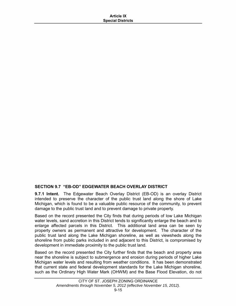
Article IX Special Districts
CITY OF ST. JOSEPH ZONING ORDINANCE Amendments through November 5, 2012 (effective November 15, 2012).
9-15
SECTION 9.7 “EB-OD” EDGEWATER BEACH OVERLAY DISTRICT 9.7.1 Intent. The Edgewater Beach Overlay District (EB-OD) is an overlay District intended to preserve the character of the public trust land along the shore of Lake Michigan, which is found to be a valuable public resource of the community, to prevent damage to the public trust land and to prevent damage to private property. Based on the record presented the City finds that during periods of low Lake Michigan water levels, sand accretion in this District tends to significantly enlarge the beach and to enlarge affected parcels in this District. This additional land area can be seen by property owners as permanent and attractive for development. The character of the public trust land along the Lake Michigan shoreline, as well as viewsheds along the shoreline from public parks included in and adjacent to this District, is compromised by development in immediate proximity to the public trust land. Based on the record presented the City further finds that the beach and property area near the shoreline is subject to submergence and erosion during periods of higher Lake Michigan water levels and resulting from weather conditions. It has been demonstrated that current state and federal development standards for the Lake Michigan shoreline, such as the Ordinary High Water Mark (OHWM) and the Base Flood Elevation, do not

Article IX Special Districts
CITY OF ST. JOSEPH ZONING ORDINANCE Amendments through November 5, 2012 (effective November 15, 2012).
9-16
ensure that property shoreward of those locations is protected from erosion, inundation, or damage during such periods of time and/or weather events. The OHWM is not intended to reflect these periods of peril, and the Base Flood Elevation is a still water elevation that does not take into account the effect of wave action. The City further understands that revised federal floodplain regulations are being developed to take into account additional environmental factors such as waves and to provide an improved standard of floodplain development protection, but implementation of these regulations will not likely occur for several years. When erosion threatens a Structure legally built near the shoreline, a natural reaction for the owner is to attempt to construct a seawall or implement similar shore protection measures. Shore protection measures in this District would diminish significantly the character of the public trust land and pose an increased threat of erosion and damage to the public trust land as well as to adjacent private property. The City has long experience with the detrimental effects of seawalls and shore protection structures constructed over a period of many years in response to erosion south of the St. Joseph River. These shore protection structures were and are necessary to protect previously developed areas of the City which are otherwise subject to regular and ongoing erosion. However, given the physical, environmental, and developmental characteristics of the EB-OD, including generally large lots which need not be developed near to the water’s edge to be economically viable and that the area is generally benefitting from accretion rather than persistent erosion, the City believes that shore protection measures should not be necessary in this area and would be detrimental to the public health, safety and welfare for reasons further identified and set forth in the City of St. Joseph, Michigan Coastal Engineering Study, dated August 17, 2012, a copy of which is on file with the City. The City believes the most appropriate, effective and reasonable method to further the public interests of protecting natural resources; preserving the economic and environmental well-being of the community; to protect the health, safety and general welfare of the community; and the general preservation or enhancement of property values is to restrict the construction of structures so near to the water’s edge as to be detrimental to the character of the public trust property and/or the vistas from neighboring public parks; and/or to be susceptible to damage resulting from inundation or erosion or to create an apparent future need for seawalls or other shore protection measures in order to protect these structures from damage resulting from inundation or erosion; and/or to be potentially built in a location that will render the structure nonconforming under the future federal floodplain protection regulations currently under development. These regulations are intended to preserve the character of the public trust property along the shoreline, protect the vistas from neighboring public parks, and prevent the construction of structures and shore protection measures which would have deleterious effects on the public trust property as well as neighboring private property. These regulations are also supported by the Comprehensive Plan, as the Future Land Use Map indicates lakefront property in this area should be used as open space and the supporting text indicates that open space areas should be maintained and encouraged along the shoreline.
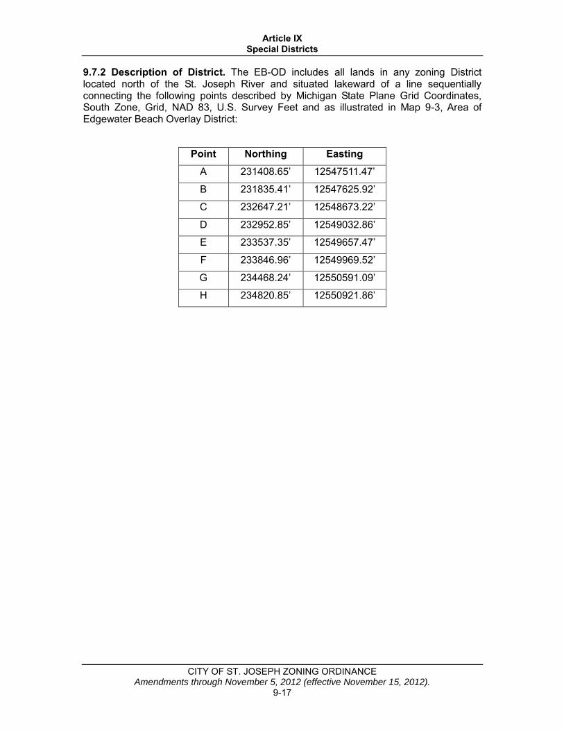
Article IX Special Districts
CITY OF ST. JOSEPH ZONING ORDINANCE Amendments through November 5, 2012 (effective November 15, 2012).
9-17
9.7.2 Description of District. The EB-OD includes all lands in any zoning District located north of the St. Joseph River and situated lakeward of a line sequentially connecting the following points described by Michigan State Plane Grid Coordinates, South Zone, Grid, NAD 83, U.S. Survey Feet and as illustrated in Map 9-3, Area of Edgewater Beach Overlay District:
Point Northing Easting A 231408.65’ 12547511.47’
B 231835.41’ 12547625.92’
C 232647.21’ 12548673.22’
D 232952.85’ 12549032.86’
E 233537.35’ 12549657.47’
F 233846.96’ 12549969.52’
G 234468.24’ 12550591.09’
H 234820.85’ 12550921.86’
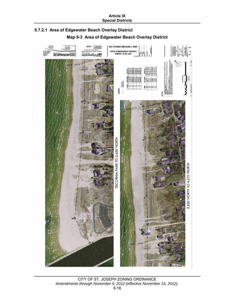
Article IX Special Districts
CITY OF ST. JOSEPH ZONING ORDINANCE Amendments through November 5, 2012 (effective November 15, 2012).
9-18
9.7.2.1 Area of Edgewater Beach Overlay District Map 9-3 Area of Edgewater Beach Overlay District

Article IX Special Districts
CITY OF ST. JOSEPH ZONING ORDINANCE Amendments through November 5, 2012 (effective November 15, 2012).
9-19
9.7.3 Structure Development. For the reasons set forth in Subsection 9.7.1 and elsewhere in this Ordinance, the installation, construction and operation of Structures, which for the purpose of this section includes seawalls and shore protection measures, within the EB-OD shall be subject to the following: A. No Structure shall be installed or constructed in the EB-OD. The following are not
considered a Structure for purposes of this section only: 1. Public recreational equipment in public parks; 2. Open, unroofed walkways, including those constructed of pavers or similar
objects; 3. Stairs and similar open, unroofed structures that are set on the surface of the
ground and which are not attached to a Structure; and 4. Freestanding signs.
B. For the purposes of this section, shore protection measures does not include temporary fencing not more than four feet (4’) in height and with openly spaced slats or weaves, placed seasonally between October 1 and May 1 to influence the accumulation of sand and/or snow and which does not prevent public passage across the public trust property.
C. In the event the provisions of the EB-OD prevents the development or use of a Lot existing on the effective date of this amendment for the purposes permitted in the Zoning District, or creates practical difficulties or unnecessary hardship for the use of such a Lot, the property owner may seek a Hardship Planned Unit Development under the terms of this Ordinance for lands within the EB-OD or a Hardship Planned Unit Development or Variance for lands adjacent to the EB-OD.
D. If any Lot within or partially within the EB-OD is divided or the subject of a boundary adjustment after the effective date of this amendment such that any resulting parcel is nonbuildable due to the regulations of this section, except for a boundary adjustment that has the effect of lessening a Nonconformity with respect to this section, it will be deemed a voluntary action of the property owner and will disqualify the resulting nonbuildable parcel from receiving a Variance or Hardship Planned Unit Development.
E. In the event the provisions of the EB-OD render Nonconforming any Structure which is existing or which is the subject of a valid building permit and under construction on the effective date of this amendment, this shall not be deemed a voluntary action of the property owner and will not disqualify the parcel from receiving a Hardship Planned Unit Development under the procedures described in this Ordinance for lands within the EB-OD or a Hardship Planned Unit Development or Variance if on lands adjacent to the EB-OD.
F. Variances shall not be permitted within the EB-OD. G. To the extent of any conflict between the regulatory provisions contained in this
section and other provisions of the Zoning Ordinance, the restrictions contained in this section shall control.

Appendix A:City of St. Joseph Zoning Ordinance B
This appendix includes:
• An excerpt from Living on the Coast: Protecting Investments in Shore Property on the Great Lakes by the U.S. Army Corps of Engineers and the University of Wisconsin Sea Grant. This excerpt describes the environmental impacts of shore protection structures. The entire document can be found at the following link: http://ready.wi.gov/CoastalErosion/Living_on_Coast.pdf.
• An excerpt from Mitigation Ideas: A Resource for Reducing Risk to Natural Hazards by FEMA on local planning tools to address flooding, sea level rise, and storm surge in order to protect a community’s infrastructure. The entire document can be found at the following link: https://www.fema.gov/media-library-data/20130726-1904-25045-0186/fema_mitigation_ideas_final508.pdf.
• An excerpt from No Adverse Impact: A Toolkit For Common Sense Floodplain Management by the Association of State Flood Plain Managers (ASFPM) on different mitigation actions a community can take to reduce damage to existing buildings that are exposed to flooding. The entire document can be found at the following link: https://www.floods.org/NoAdverseImpact/NAI_Toolkit_2003.pdf.
• An excerpt from Low Impact Development Manual for Michigan: A Design Guide for Implementers and Reviewers by the Southeast Michigan Council of Governments (SEMCOG). This excerpt includes a checklist on ways to include Low Impact Development into site plan review and design processes. The entire document can be found at the following link: http://www.semcog.org/reports/lid/index.html#.
• A resource guide of example model ordinances on a variety of coastal resiliency concepts.
Appendix B:Other Resources

Livingon the
Coast
Protecting Investments
in Shore Property
on the Great Lakes
Protecting Investments
in Shore Property
on the Great Lakes
Detro
it Distric
t

S E C T I O N T I T L E 1
L I V I N G O N T H E C O A S T
TABLE OF CONTENTSIntroduction . . . . . . . . . . . . . . . . . . . . . . . . . . . . . . . . . . . . . . . . . . . . . . . . . . . . . . . . . . . . . . . . . . 1
Natural Processes That Affect the Coast . . . . . . . . . . . . . . . . . . . . . . . . . . . . . . . . . . . . . . . . . . . . 2
The Legacy of the Glaciers . . . . . . . . . . . . . . . . . . . . . . . . . . . . . . . . . . . . . . . . . . . . . . . . . . . . . 2
Lake Level Responses to Weather and Climate . . . . . . . . . . . . . . . . . . . . . . . . . . . . . . . . . . . . . . 2
Plausible Future Climate Effects on Lake Levels . . . . . . . . . . . . . . . . . . . . . . . . . . . . . . . . . . . . . 3
Human Influence on Lake Levels . . . . . . . . . . . . . . . . . . . . . . . . . . . . . . . . . . . . . . . . . . . . . . . . 4
Storms and Storm Surges. . . . . . . . . . . . . . . . . . . . . . . . . . . . . . . . . . . . . . . . . . . . . . . . . . . . . . . 4
Waves and Wave Climate . . . . . . . . . . . . . . . . . . . . . . . . . . . . . . . . . . . . . . . . . . . . . . . . . . . . . . 5
Local Wave Conditions . . . . . . . . . . . . . . . . . . . . . . . . . . . . . . . . . . . . . . . . . . . . . . . . . . . . . . . . 5
Local Water Currents . . . . . . . . . . . . . . . . . . . . . . . . . . . . . . . . . . . . . . . . . . . . . . . . . . . . . . . . . 6
Longshore and Cross-Shore Transport of Sediment . . . . . . . . . . . . . . . . . . . . . . . . . . . . . . . . . . . 7
Ice on the Shore . . . . . . . . . . . . . . . . . . . . . . . . . . . . . . . . . . . . . . . . . . . . . . . . . . . . . . . . . . . . . 8
Shoreline Erosion . . . . . . . . . . . . . . . . . . . . . . . . . . . . . . . . . . . . . . . . . . . . . . . . . . . . . . . . . . . . 9
Lakebed Erosion . . . . . . . . . . . . . . . . . . . . . . . . . . . . . . . . . . . . . . . . . . . . . . . . . . . . . . . . . . . . . 10
How Stable is a Shoreline Slope? . . . . . . . . . . . . . . . . . . . . . . . . . . . . . . . . . . . . . . . . . . . . . . . . . 11
Water on the Land . . . . . . . . . . . . . . . . . . . . . . . . . . . . . . . . . . . . . . . . . . . . . . . . . . . . . . . . . . . 12
Protecting Your Coastal Investment . . . . . . . . . . . . . . . . . . . . . . . . . . . . . . . . . . . . . . . . . . . . . . . . 15
Knowing Where You Are on Coastal Property . . . . . . . . . . . . . . . . . . . . . . . . . . . . . . . . . . . . . . . 15
Adaptation to Natural Processes . . . . . . . . . . . . . . . . . . . . . . . . . . . . . . . . . . . . . . . . . . . . . . . . . 16
Staying out of nature’s way . . . . . . . . . . . . . . . . . . . . . . . . . . . . . . . . . . . . . . . . . . . . . . . . . . . 16
Relocating threatened buildings. . . . . . . . . . . . . . . . . . . . . . . . . . . . . . . . . . . . . . . . . . . . . . . . 17
Restoration of a Natural Shoreline . . . . . . . . . . . . . . . . . . . . . . . . . . . . . . . . . . . . . . . . . . . . . . . . 18
Retaining and nourishing beaches . . . . . . . . . . . . . . . . . . . . . . . . . . . . . . . . . . . . . . . . . . . . . . 18
Revegetating the shore. . . . . . . . . . . . . . . . . . . . . . . . . . . . . . . . . . . . . . . . . . . . . . . . . . . . . . . 18
Constructing dunes and beach ridges . . . . . . . . . . . . . . . . . . . . . . . . . . . . . . . . . . . . . . . . . . . 19
Creating or restoring wetlands . . . . . . . . . . . . . . . . . . . . . . . . . . . . . . . . . . . . . . . . . . . . . . . . 20
Removing failed or failing structures . . . . . . . . . . . . . . . . . . . . . . . . . . . . . . . . . . . . . . . . . . . . 20
Moderation of Erosion. . . . . . . . . . . . . . . . . . . . . . . . . . . . . . . . . . . . . . . . . . . . . . . . . . . . . . . . . 21
Making a bluff or bank more stable . . . . . . . . . . . . . . . . . . . . . . . . . . . . . . . . . . . . . . . . . . . . . 21
Managing water on the land . . . . . . . . . . . . . . . . . . . . . . . . . . . . . . . . . . . . . . . . . . . . . . . . . . 22
Slowing wind erosion . . . . . . . . . . . . . . . . . . . . . . . . . . . . . . . . . . . . . . . . . . . . . . . . . . . . . . . 23
Improving existing protective structures . . . . . . . . . . . . . . . . . . . . . . . . . . . . . . . . . . . . . . . . . 23
Tripping waves . . . . . . . . . . . . . . . . . . . . . . . . . . . . . . . . . . . . . . . . . . . . . . . . . . . . . . . . . . . . 23
Armoring the lakebed . . . . . . . . . . . . . . . . . . . . . . . . . . . . . . . . . . . . . . . . . . . . . . . . . . . . . . . 23
Armoring the Shore. . . . . . . . . . . . . . . . . . . . . . . . . . . . . . . . . . . . . . . . . . . . . . . . . . . . . . . . . . . 24
Revetments . . . . . . . . . . . . . . . . . . . . . . . . . . . . . . . . . . . . . . . . . . . . . . . . . . . . . . . . . . . . . . . 24
Seawalls. . . . . . . . . . . . . . . . . . . . . . . . . . . . . . . . . . . . . . . . . . . . . . . . . . . . . . . . . . . . . . . . . . 26
Groins . . . . . . . . . . . . . . . . . . . . . . . . . . . . . . . . . . . . . . . . . . . . . . . . . . . . . . . . . . . . . . . . . . . 27
Breakwaters . . . . . . . . . . . . . . . . . . . . . . . . . . . . . . . . . . . . . . . . . . . . . . . . . . . . . . . . . . . . . . . 28
Unsuitable shore protection. . . . . . . . . . . . . . . . . . . . . . . . . . . . . . . . . . . . . . . . . . . . . . . . . . . 28
Page

2 S E C T I O N T I T L E
P R O T E C T I N G G R E A T L A K E S C O A S T A L P R O P E R T YL I V I N G O N T H E C O A S T
Junk shore protection . . . . . . . . . . . . . . . . . . . . . . . . . . . . . . . . . . . . . . . . . . . . . . . . . . . . . . . 29
Proprietary shore protection systems . . . . . . . . . . . . . . . . . . . . . . . . . . . . . . . . . . . . . . . . . . . . 29
Environmental Impacts of Shore Protection Structures . . . . . . . . . . . . . . . . . . . . . . . . . . . . . . . . 29
Impacts of groins. . . . . . . . . . . . . . . . . . . . . . . . . . . . . . . . . . . . . . . . . . . . . . . . . . . . . . . . . . . 30
Impacts of seawalls and revetments . . . . . . . . . . . . . . . . . . . . . . . . . . . . . . . . . . . . . . . . . . . . 30
Impacts of breakwaters . . . . . . . . . . . . . . . . . . . . . . . . . . . . . . . . . . . . . . . . . . . . . . . . . . . . . . 31
Water safety, shoreline aesthetics, altered habitat and cumulative impacts . . . . . . . . . . . . . . . . 31
Private actions, public consequences . . . . . . . . . . . . . . . . . . . . . . . . . . . . . . . . . . . . . . . . . . . . 31
Working with Engineers and Contractors . . . . . . . . . . . . . . . . . . . . . . . . . . . . . . . . . . . . . . . . . . 32
The Economics of Protecting Your Coastal Investment . . . . . . . . . . . . . . . . . . . . . . . . . . . . . . . . . 34
Shoreline Property Features and Value . . . . . . . . . . . . . . . . . . . . . . . . . . . . . . . . . . . . . . . . . . . . 34
Will Government Regulations Protect a Coastal Investment?. . . . . . . . . . . . . . . . . . . . . . . . . . . . 35
Costs of Shore Protection . . . . . . . . . . . . . . . . . . . . . . . . . . . . . . . . . . . . . . . . . . . . . . . . . . . . . . 36
Initial costs . . . . . . . . . . . . . . . . . . . . . . . . . . . . . . . . . . . . . . . . . . . . . . . . . . . . . . . . . . . . . . . 36
Maintenance costs . . . . . . . . . . . . . . . . . . . . . . . . . . . . . . . . . . . . . . . . . . . . . . . . . . . . . . . . . . 36
Risk Management . . . . . . . . . . . . . . . . . . . . . . . . . . . . . . . . . . . . . . . . . . . . . . . . . . . . . . . . . . . . 36
Accounting for Climate Change . . . . . . . . . . . . . . . . . . . . . . . . . . . . . . . . . . . . . . . . . . . . . . . . . 38
Summary . . . . . . . . . . . . . . . . . . . . . . . . . . . . . . . . . . . . . . . . . . . . . . . . . . . . . . . . . . . . . . . . . . . . 39
Where to Go for More Information . . . . . . . . . . . . . . . . . . . . . . . . . . . . . . . . . . . . . . . . . . . . . . . . 40
Agencies That Regulate Great Lakes Shorelands . . . . . . . . . . . . . . . . . . . . . . . . . . . . . . . . . . . . . . 43
Glossary of Coastal Engineering Terms . . . . . . . . . . . . . . . . . . . . . . . . . . . . . . . . . . . . . . . . . . . . . 45
Review Group. . . . . . . . . . . . . . . . . . . . . . . . . . . . . . . . . . . . . . . . . . . . . . . . . . . . . . . . . . . . . . . . . 49
Page

Environmental Impacts of Shore Protection Structures
Shore protection structures are intended to have an
effect on the coast—to stop erosion of uplands or to stop
erosion of beaches or both. Shore protection structures
can have beneficial impacts by stabilizing beaches and by
preventing shore land retreat behind the structures. Shore
protection structures are controversial and can impact the
shore in undesirable ways. A limited ability to predict the
long-term impacts of such structures on other shoreline
properties is a concern for designers and for the owners
of the structures.
Construction activity in building such structures has
temporary, negative impacts. Equipment damages or
destroys vegetative cover, beach and nearshore habitat.
P R O T E C T I N G Y O U R C O A S T A L I N V E S T M E N T 29
L I V I N G O N T H E C O A S T

The activity may cause short-term and local increases in
water turbidity.
Many shore protection structures replace natural,
area-based shore defenses with linear defenses. One prob-
lem with this substitution is that the area-based erosive
attack of storm waves may require an area-based defense.
Natural shoreline defenses break storm waves and
absorb their power over the broad areas of shoals, barred
lakebeds and beach slopes before the destructive waves
reach the highly erodible faces of coastal upland slopes.
During storms and periods of high lake levels, some of
the mobile material is borrowed from the beach as the
defenses are rearranged. When waves subside and water
levels drop, the borrowed material may be returned to the
beach. Losses of mobile materials are made up by new
supplies, unless people, or nature, interfere. Other area-
based defenses include bedrock outcrops near shore and
on shore.
Constructed, linear defenses are intentional barriers
to the offshore movement of upland beach materials,
blocking one of the natural responses to wave attack.
Near these barriers, mobile materials are “borrowed”
from adjoining unprotected shore slopes, beaches, and
the nearshore lakebed to respond to wave attack in front
of the linear structures. This borrowing makes neighbors’
unprotected coastal properties more vulnerable to dam-
aging wave attack.
Where shore protection structures mimic nature, the
defense is like an area-based defense. Examples include
confined and maintained beach nourishment, lakebed
armoring, armored mini-“headlands” and captive beach-
es, and submerged nearshore breakwaters.
The negative effects of shore protection structures
tend to be greater for structures that are perpendicular to
shore than for shore-parallel structures. The negative
effects tend to be less for structures landward of the active
beach than for structures in the water or at the water’s
edge. The negative effects also tend to be less for perme-
able structures than for impermeable structures. The
magnitude of a structure’s interference with natural sedi-
ment movement increases with the length of the struc-
ture. An experienced professional is needed to design a
structure appropriate to site conditions that maximizes
performance and minimizes adverse impacts to client’s
and neighbors’ properties.
Impacts of groins
Modern engineering practice is to combine groin con-
struction with beach nourishment. The intended purpose
of a groin or groin field is the retention of beach materi-
al, in order to widen or maintain the width of the beach
without depriving down-drift properties of beach-build-
ing littoral material. The practice is also to keep groins
and compartments between groins filled.
There is a short supply of experience in designing
groins and groin fields without negative impacts.
Negative local and distant impacts include a narrowing of
down-drift beaches, an increase in down-drift erosion,
and increased lakebed erosion. Groins that are not main-
tained in a filled condition have beach material accreting
on the up-drift side of the barrier with a net loss of beach
and nearshore material affecting multiple properties on
the down-drift side. The higher and longer a groin is, the
more material is captured and the greater the impact on
adjacent beaches. The impacted shoreline may continue
to lengthen long after construction has been completed.
The placement of one groin often leads to the need for
another. Before long, a series of groins forms a groin field
that will take longer to fill, cause a greater disruption to
longshore sediment transport and increase the cumula-
tive effects on properties down the coast.
Negative impacts of groins can be reduced by using
short, low-profile groins no higher than the designed or
natural beach elevation to allow for overtopping and
bypassing of material to the adjacent shoreline. Impacts
can be reduced by locating the water end of a groin land-
ward of the shoreward boundary of the breaker zone at
high water levels. Frequent changes in direction of long-
shore transport, changes in water levels, and the erosive
nature of storm waves on the Great Lakes combine to
empty groin compartments, requiring refilling or increas-
ing negative impacts.
Impacts of seawalls and revetments
The best chances for seawalls and revetments to work
with minimal adverse environmental impact is where the
structures are placed at the intersection of an upland
slope and a broad sandy beach, and where there is a gen-
30 P R O T E C T I N G Y O U R C O A S T A L I N V E S T M E N T
P R O T E C T I N G G R E A T L A K E S C O A S T A L P R O P E R T YL I V I N G O N T H E C O A S T
A negative impact common to all shore protection structures is that the intentional halting of
erosion landward of the structures robs the littoral transport system of beach-building
materials—sand, gravel and rocks.
tle nearshore lakebed slope with abundant longshore
transport of sediment. Structures placed landward of the
beach will serve as a defense of last resort when rising
lake levels and/or severe storms temporarily wipe out nat-
ural beach defenses against erosion. During times of
falling and low lake levels, wind-blown sand covers some
low structures built against the upland slope. Only the
sandy beach is visible. Minimal adverse impacts may also
be expected where there is minimal longshore sediment
transport and an erosion-resistant lakebed. Minimal
impacts can be expected where the structure augments
natural protection, such as a seawall built on a too-low,
sloping bedrock shore.
The closer that a seawall or revetment is to the water,
the greater the negative impacts on the protected proper-
ty and on neighboring properties. Shore protection struc-
tures in the water or at the water’s edge reflect wave ener-
gy, alter longshore currents, and may alter sediment
transport. Storm waves can cause localized lakebed scour
in front of, and at the ends of, the structures. Deepening
of the water in front of a lake-edge seawall or revetment
by localized scour or lakebed erosion may undermine the
structure and cause it to collapse.
During periods of low water levels, shoreland should
not be “reclaimed” by building revetments and seawalls
near the receded water’s edge to protect beaches, sand
ridges, and swales that have emerged while lake levels
were declining. Structures built in these locations inter-
fere with the beneficial restoration of natural shore pro-
tective buffers and may be destroyed when high lake lev-
els return and storms occur.
Impacts of breakwaters
A nearshore breakwater breaks waves and creates a
zone of quiet water on the inshore, sheltered lee side of
the structure where a change in habitat and animal com-
munities is likely to occur. Longshore movements of fish
may be impeded. This local change in nearshore condi-
tions can contribute to a local degradation in water qual-
ity and cause longshore transport to deposit sediments in
the sheltered waters. Breakwaters can deflect longshore
sediment transport offshore into deep water where the
material will not return to the nearshore and to beaches.
Designers shape breakwaters to maximize desired
effects and reduce negative impacts. A breakwater may be
located lakeward of the normal breaker zone, or the
structure length may be made less than the distance
between the structure and shore to avoid the creation of
a shoreline spit that eventually reaches the breakwater
and forms a “tombolo” that blocks longshore sediment
transport between the structure and the shore.
Water safety, shoreline aesthetics, altered habitat, andcumulative impacts
Rip currents that are dangerous to swimmers can be
formed adjacent to long groins or piers, where structures
have altered nearshore bar formation, and within the
water cells framed by breakwaters and pocket beaches.
As more shorelines become developed, armored, and
exposed at low water levels, the massive appearance of
many shore protection structures becomes a growing
issue with neighbors and with regulators as the shore
loses its natural look.
Shoreline and nearshore habitats on the Great Lakes
are important. Shore protection structures may alter habi-
tat for birds and other animals living in nearshore waters
and on the beach. Shoreline waters are used by many fish
and by organisms on which fish feed. The influence of
shore protection structures on these nearshore habitats is
poorly understood but could have significant effects on
the Great Lakes fishery over long periods of time as such
structures multiply.
As shoreline structures multiply along a section or
reach of shoreline, cumulative impacts are of growing
concern. Cumulative impacts are poorly understood and
have had little investigation. The issue can appear in at
least three ways: 1) impacts on the shoreline and
nearshore from the addition of multiple shore protection
structures, 2) a total impact greater than the sum of
effects from individual structures, and 3) impacts from
one or more structures multiplying over time and dis-
tance along a shore.
Private actions, public consequences
Private actions on private property can have public
consequences. This is often the case for slope stabiliza-
tion and shore protection on coastal property. Private
actions may adversely affect the properties of neighbors
and more distant residents along the coast. The adverse
effects are progressive over time and distance. Some of
these adverse effects may be undetected, occurring in the
midst of shore-land changes caused by winds, water on
the land, storm waves, and lake level changes. The public
P R O T E C T I N G Y O U R C O A S T A L I N V E S T M E N T 31
L I V I N G O N T H E C O A S T
Construction of any shore protection structure that impedes the longshore transport ofsediment should be avoided, or approached with extreme caution.
consequences of private shore protection actions become
more significant as coastal investments increase, and
beaches diminish.
Distant public and private actions far from any shore
protection structure may also be responsible for the loss-
es of beaches and protective nearshore bars. Beach sand
and gravel from inland sources are lost or diminished by
soil erosion control, construction of dams and breakwa-
ters, harbor deepening (creating sediment traps) and the
placement of dredged material containing clean sand and
gravel in upland locations or offshore sites beyond the
reach of the littoral system.
P R O T E C T I N G G R E A T L A K E S C O A S T A L P R O P E R T YL I V I N G O N T H E C O A S T
32 P R O T E C T I N G Y O U R C O A S T A L I N V E S T M E N T

Mitigation IdeasA Resource for Reducing Risk to Natural Hazards
January 2013
01024.13
3
Table of Contents
Introduction.................................................................................................................................................... 4
Drought............................................................................................................................................................ 5
Earthquake......................................................................................................................................................9
Erosion............................................................................................................................................................ 15
Extreme Temperatures ................................................................................................................................19
Flood ............................................................................................................................................................... 21
Hail ..................................................................................................................................................................33
Landslide ........................................................................................................................................................35
Lightning ...................................................................................................................................................... 39
Sea Level Rise................................................................................................................................................41
Severe Wind ................................................................................................................................................. 45
Severe Winter Weather ............................................................................................................................... 51
Storm Surge.................................................................................................................................................. 55
Subsidence.................................................................................................................................................... 59
Tornado.......................................................................................................................................................... 63
Tsunami ......................................................................................................................................................... 65
Wildfire ..........................................................................................................................................................69
Multiple Hazards ..........................................................................................................................................75
FEMA Resources/Publications .................................................................................................................. 83
FEMA Contacts .............................................................................................................................................88
Table of Contents
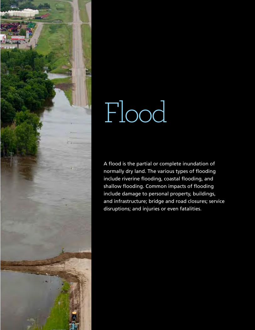
FloodA flood is the partial or complete inundation of
normally dry land. The various types of flooding
include riverine flooding, coastal flooding, and
shallow flooding. Common impacts of flooding
include damage to personal property, buildings,
and infrastructure; bridge and road closures; service
disruptions; and injuries or even fatalities.

22 Mitigation Ideas: A Resource for Reducing Risk to Natural Hazards
Local Planning and Regulations
F-1 Incorporate Flood Mitigationin Local Planning
FEMA Resources/Publications FEMA 100, 268, 473
Comprehensive planning and floodplain management can mitigateflooding by influencing development. Strategies include:
▪ Determining and enforcing acceptable land uses to alleviate the risk of damage by limiting exposure in flood hazard areas. Floodplain and coastal zone management can be included in comprehensive planning.
▪ Developing a floodplain management plan and updating it regularly.
▪ Mitigating hazards during infrastructure planning. For example, decisions to extend roads or utilities to an area may increase exposure to flood hazards.
▪ Adopting a post-disaster recovery ordinance based on a plan to regulate repair activity, generally depending on property location.
▪ Passing and enforcing an ordinance that regulates dumping in streams and ditches.
▪ Establishing a ”green infrastructure” program to link, manage, and expand existing parks, preserves, greenways, etc.
▪ Obtaining easements for planned and regulated public use of privately-owned land for temporary water retention and drainage.
F-2 Form Partnershipsto Support FloodplainManagement
Partnerships between local, state, and regional entities help expandresources and improve coordination. Consider the following actions:
▪ Developing a stormwater committee that meets regularly to discuss issues and recommend projects.
▪ Forming a regional watershed council to help bring together resources for comprehensive analysis, planning, decision-making, and cooperation.
▪ Establishing watershed-based planning initiatives to address the flood hazard with neighboring jurisdictions.
▪ Forming a citizen plan implementation steering committee to monitor progress on local mitigation actions. Include a mix of representatives from neighborhoods, local businesses, and local government.

23
Flood Local Planning and Regulations
Mitigation Ideas: A Resource for Reducing Risk to Natural Hazards
F-3 Limit or RestrictDevelopment inFloodplain Areas
FEMA Resources/Publications FEMA 100, 268, 473
Flooding can be mitigated by limiting or restricting howdevelopment occurs in floodplain areas through actions such as:
▪ Prohibiting or limiting floodplain development through regulatory and/or incentive-based measures.
▪ Limiting the density of developments in the floodplain. ▪ Requiring that floodplains be kept as open space. ▪ Limiting the percentage of allowable impervious surface within
developed parcels. ▪ Developing a stream buffer ordinance to protect water resources
and limit flood impacts. ▪ Prohibiting any fill in floodplain areas.
The use of building codes and development standards can ensurestructures are able to withstand flooding. Potential actions include:
▪ Adopting the International Building Code (IBC) and International Residential Code (IRC).
▪ Adopting ASCE 24-05 Flood Resistant Design and Construction. ASCE 24 is a referenced standard in the IBC that specifies minimum requirements and expected performance for the design and construction of buildings and structures in the flood hazard areas to make them more resistant to flood loads and flood damage.
▪ Adding or increasing “freeboard” requirements (feet above base flood elevation) in the flood damage ordinance.
▪ Prohibiting all first floor enclosures below base flood elevation for all structures in flood hazard areas.
▪ Considering orientation of new development during design (e.g., subdivisions, buildings, infrastructure, etc.).
▪ Setting the design flood elevation at or above the historical high water mark if it is above the mapped base flood elevation.
▪ Using subdivision design standards to require elevation data collection during platting and to have buildable space on lots above the base flood elevation.
▪ Requiring standard tie-downs of propane tanks.
F-4 Adopt and EnforceBuilding Codes andDevelopment Standards
FEMA Resources/Publications FEMA 100, 268, P-762

24
Local Planning and Regulations
Mitigation Ideas: A Resource for Reducing Risk to Natural Hazards
F-5 Improve StormwaterManagement Planning
Rainwater and snowmelt can cause flooding and erosion indeveloped areas. Stormwater management practices to preventthis include:
▪ Completing a stormwater drainage study for known problem areas. ▪ Preparing and adopting a stormwater drainage plan and ordinance. ▪ Preparing and adopting a community-wide stormwater
management master plan. ▪ Regulating development in upland areas in order to reduce
stormwater run-off through a stormwater ordinance. ▪ Linking flood hazard mitigation objectives with EPA Stormwater
Phase II initiatives. ▪ Developing engineering guidelines for drainage from
new development. ▪ Requiring a drainage study with new development. ▪ Encouraging the use of Low Impact Development techniques
F-6 Adopt Polices to ReduceStormwater Runoff
In addition to stormwater management, techniques to reduce rainrunoff can prevent flooding and erosion, such as:
▪ Designing a “natural runoff” or “zero discharge” policy for stormwater in subdivision design.
▪ Requiring more trees be preserved and planted in landscape designs to reduce the amount of stormwater runoff.
▪ Requiring developers to plan for on-site sediment retention. ▪ Requiring developers to construct on-site retention basins for
excessive stormwater and as a firefighting water source. ▪ Encouraging the use of porous pavement, vegetative buffers, and
islands in large parking areas. ▪ Conforming pavement to land contours so as not to provide easier
avenues for stormwater. ▪ Encouraging the use of permeable driveways and surfaces to
reduce runoff and increase groundwater recharge. ▪ Adopting erosion and sedimentation control regulations for
construction and farming.
25
Flood Local Planning and Regulations
Mitigation Ideas: A Resource for Reducing Risk to Natural Hazards
F-7 Improve FloodRisk Assessment
FEMA Resources/Publications FEMA 416, 467-1, B-797
Heighten awareness of flood risk with the following:
▪ Incorporating the procedures for tracking high water marks following a flood into emergency response plans.
▪ Conducting cumulative impact analyses for multiple development projects within the same watershed.
▪ Conducting a verification study of FEMA’s repetitive loss inventory and developing an associated tracking database.
▪ Regularly calculating and documenting the amount of flood-prone property preserved as open space.
▪ Requiring a thorough watershed analysis for all proposed dam or reservoir projects.
▪ Developing a dam failure study and emergency action plan. ▪ Using GIS to map areas that are at risk of flooding. ▪ Obtaining depth grid data and using it to illustrate flood risk
to citizens. ▪ Incorporating digital floodplain and topographic data into GIS
systems, in conjunction with Hazus, to assess risk. ▪ Developing and maintaining a database to track community
exposure to flood risk. ▪ Revising and updating regulatory floodplain maps.
F-8 Join or Improve Compliancewith NFIP
FEMA Resources/Publications FEMA 100, 209, FIA-15A, NFIP Technical Bulletins
The National Flood Insurance Program (NFIP) enables propertyowners in participating communities to purchase insuranceprotection against flood losses. Actions to achieve eligibility andmaintain compliance include:
▪ Participating in NFIP. ▪ Adopting ordinances that meet minimum Federal and state
requirements to comply with NFIP. ▪ Conducting NFIP community workshops to provide information
and incentives for property owners to acquire flood insurance. ▪ Designating a local floodplain manager and/or CRS coordinator
who achieves CFM certification. ▪ Completing and maintaining FEMA elevation certificates for
pre-FIRM and/or post-FIRM buildings. ▪ Requiring and maintaining FEMA elevation certificates for all new
and improved buildings located in floodplains.

26
Local Planning and Regulations
Mitigation Ideas: A Resource for Reducing Risk to Natural Hazards
F-9 Manage the FloodplainBeyond MinimumRequirements
FEMA Resources/Publications FEMA 100, 209, 213, 268, 480; FIA-15A
In addition to participation in NFIP, implementing good floodplainmanagement techniques that exceed minimum requirements canhelp minimize flood losses. Examples include:
▪ Incorporating the ASFPM’s “No Adverse Impact” policy into local floodplain management programs.
▪ Revising the floodplain ordinance to incorporate cumulative substantial damage requirements.
▪ Adopting a “no-rise” in base flood elevation clause for the flood damage prevention ordinance.
▪ Extending the freeboard requirement past the mapped floodplain to include an equivalent land elevation.
▪ Including requirements in the local floodplain ordinance for homeowners to sign non-conversion agreements for areas below base flood elevation.
▪ Establishing and publicizing a user-friendly, publicly-accessible repository for inquirers to obtain Flood Insurance Rate Maps.
▪ Developing an educational flyer targeting NFIP policyholders on increased cost of compliance during post-flood damage assessments.
▪ Annually notifying the owners of repetitive loss properties of Flood Mitigation Assistance funding.
▪ Offering incentives for building above the required freeboard minimum (code plus).
F-10 Participate in the CRS
FEMA Resources/Publications FEMA 100, 209, 213, 268, 480; FIA-15A
The Community Rating System (CRS) rewards communities thatexceed the minimum NFIP requirements. Depending upon thelevel of participation, flood insurance premium rates are discountedfor policyholders. Potential activities that are eligible to receivecredit include:
▪ Advising the public about the local flood hazard, flood insurance, and flood protection measures.
▪ Enacting and enforcing regulations that exceed NFIP minimum standards so that more flood protection is provided for new development.
▪ Implementing damage reduction measures for existing buildings such as acquisition, relocation, retrofitting, and maintenance of drainageways and retention basins.
▪ Taking action to minimize the effects of flooding on people, property, and building contents through measures including flood warning, emergency response, and evacuation planning.
F-11 Establish LocalFunding Mechanismsfor Flood Mitigation
Potential methods to develop local funding sources for floodmitigation include:
▪ Using taxes to support a regulatory system. ▪ Using impact fees to help fund public projects to mitigate impacts of
land development (e.g., increased runoff). ▪ Levying taxes to finance maintenance of drainage systems and
capital improvements.

Sea Level Rise
Sea level rise causes land loss in low-lying coastal areas,
such as coastal wetlands and barrier islands, and occurs
at the highest rates where land is already subsiding. Sea
level rise also exacerbates erosion and flooding as new
areas become vulnerable to storm surge, wave action,
and tides.1 Climate change models predict that sea level
risk will accelerate in the next century. This could result
in billions of dollars in losses.
1 Adapting to Climate Change: A Planning Guide for State Coastal Managers,National Oceanic and Atmospheric Administration Office of Ocean and CoastalResource Management, 2010.

42 Mitigation Ideas: A Resource for Reducing Risk to Natural Hazards
Local Planning and Regulations
SLR-1 Map and AssessVulnerability to Sea Level Rise
To better understand and assess local vulnerability to sea level rise,consider actions such as:
▪ Modeling various “what-if” scenarios to estimate potential vulnerabilities in order to develop sea level rise mitigation priorities.
▪ Using GIS to map hazard areas, at-risk structures, and associated hazards (e.g., flood and storm surge) to assess high-risk areas.
▪ Developing an inventory of public buildings and infrastructure that may be particularly vulnerable to sea level rise.
▪ Adding future conditions hydrology and areas that may be inundated by sea level rise to Digital Flood Insurance Rate Maps (DFIRM).
SLR-2 Manage Development inHigh-Risk Areas
Local governments can mitigate future losses resulting from sea levelrise by regulating development in potential hazard areas throughland use planning, including:
▪ Using zoning, subdivision regulations, and/or a special sea level rise overlay district to designate high-risk areas and specify the conditions for the use and development of specific areas.
▪ Promoting conservation and management of open space, wetlands, and/or sea level rise boundary zones to separate developed areas from high-hazard areas.
▪ Prohibiting the redevelopment of areas destroyed by storms or chronic erosion in order to prevent future losses.
▪ Encouraging compact community design in low-risk areas. ▪ Establishing setbacks in high-risk areas that account for potential
sea level rise.
SRL-3 Prevent InfrastructureExpansion in High-Risk Areas
Future development can be protected from damage resulting fromsea level rise through the following:
▪ Setting guidelines for annexation and service extensions in high-risk areas.
▪ Locating utilities and critical facilities outside of areas susceptible to sea level rise to decrease the risk of service disruption.
▪ Requiring all critical facilities to be built 1 foot above the 500-year flood elevation (considering wave action) or the predicted sea level rise level, whichever is higher.

43
Sea Level Rise
Mitigation Ideas: A Resource for Reducing Risk to Natural Hazards
Structure and Infrastructure Projects
SRL-4 Protect Buildingsand Infrastructure
Existing structures, infrastructure, and critical facilities can beprotected from sea level rise through the following:
▪ Acquiring and demolishing or relocating structures located in high-risk areas.
▪ Retrofitting structures to elevate them above potential sea level rise levels.
▪ Retrofitting critical facilities to be 1 foot above the 500-year flood elevation (considering wave action) or the predicted sea level rise level, whichever is higher.
▪ Replacing exterior building components with more hazard-resistant materials.
Natural Systems Protection
SLR-5 Preserve High-HazardAreas as Open Space
Preserve open space to benefit natural resources and to reduce riskto structures from potential sea level rise. Techniques include:
▪ Developing an open space acquisition, reuse, and preservation plan targeting hazard areas.
▪ Developing a land banking program for the preservation and management of the natural and beneficial functions of flood hazard areas.
▪ Adopting rolling easements along the shoreline to promote natural migration of shorelines.
▪ Using transfer of development rights to allow a developer to increase densities on another parcel that is not at risk in return for keeping floodplain areas vacant.
▪ Compensating an owner for partial rights, such as easement or development rights, to prevent a property from being developed.
44 Mitigation Ideas: A Resource for Reducing Risk to Natural Hazards
Natural Systems Protection
SLR-6 Protect and RestoreNatural Buffers
Natural resources provide floodplain protection, riparian buffers, andother ecosystem services that mitigate sea level rise. It is importantto preserve such functionality with the following:
▪ Examining the appropriate use of beach nourishment, sand scraping, dune-gap plugs, etc., for coastal hazards.
▪ Implementing dune restoration, plantings (e.g., sea oats), and use of natural materials.
▪ Examining the appropriate use of sediment-trapping vegetation, sediment mounds, etc., for coastal hazards.
▪ Planting sediment-trapping vegetation to buffer the coast against coastal storms by collecting sediment in protective features such as dunes or barrier islands.
▪ Performing sand scraping—using bulldozers to deposit the top foot of sand above the high-tide line—to reinforce the beach without adding new sand.
▪ Using sediment mounds to act as artificial dunes or plugs for natural dune gaps in order to slow the inland progress of storm-related wind and water.
Education and Awareness Programs
SLR-7 Increase Awareness ofSea Level Rise
Improve public awareness of risks due to sea level rise throughoutreach activities such as:
▪ Encouraging homeowners to purchase flood insurance. ▪ Using outreach programs to facilitate technical assistance programs
that address measures that citizens can take or facilitate funding for mitigation measures.
▪ Annually distributing flood protection safety pamphlets or brochures to the owners of property in high-risk areas.
▪ Educating citizens about safety during flood conditions, including the dangers of driving on flooded roads.
▪ Using outreach programs to advise homeowners of risks to life, health, and safety.
▪ Offering GIS hazard mapping online for residents and design professionals.
▪ Disclosing the location of possible sea level rise areas to potential buyers.
Other sea level rise-related mitigation actions may also apply to other hazards. See the sections entitled “Flood,” “Storm Surge,” “Erosion,” and “Multiple Hazards” for other possible ideas.
Climate change is likely to exacerbate the effects of other hazards as well. See the other sections for possible ideas.

Storm SurgeA storm surge is a large dome of water, often 50 to
100 miles wide, that rises anywhere from 4 to 5 feet
in a Category 1 hurricane and up to more than 30 feet
in a Category 5 storm. Storm surge arrives prior to a
hurricane’s landfall, and the greater the hurricane’s
intensity, the sooner the surge arrives. Storm surge can
be devastating to coastal regions, causing flooding,
severe beach erosion, and property damage along the
immediate coast. Furthermore, water can rise very rapidly
due to storm surge, posing a serious threat to people
remaining in inundation areas.
56 Mitigation Ideas: A Resource for Reducing Risk to Natural Hazards
Local Planning and Regulations
SS-1 Adopt Building Codesand Development Standards
Building codes and development standards can be established tomitigate storm surge damage. Possible regulations include:
▪ Adopting the International Building Code (IBC) and International Residential Code (IRC).
▪ Adopting ASCE-24-05 Flood Resistant Design and Construction. ASCE 24, created by the American Society of Civil Engineers, is a referenced standard in the IBC that specifies minimum requirements and expected performance for the design and construction of buildings and structures in flood hazard areas to make them more resistant to flood loads and flood damage.
▪ Establishing design standards for buildings located in areas susceptible to storm surge.
▪ Implementing V-zone construction requirements for new development located in coastal A-zones.
▪ Adopting building requirements for higher elevation in inundation zones.
▪ Requiring open foundations (e.g., piles or piers) in coastal areas. ▪ Requiring deep foundations in order to avoid erosion and scour.
SS-2 Improve Land UsePlanning and Regulations
Land uses should be planned and regulated to minimize the impactof storm surge. Possible measures to implement include:
▪ Developing and maintaining a beach management plan. ▪ Adopting shoreline setback regulations and establishing coastal
setback lines. ▪ Adopting coastal zone management regulations. ▪ Eliminating all obstructions in areas along the coast subject to
inundation by the 1-percent-annual-chance flood event with additional hazards associated with storm-induced waves (also known as the V-zone).
▪ Planning for future storm surge heights due to sea level rise. ▪ Limiting or prohibiting development in areas along the coast
subject to inundation by the 1-percent-annual-chance flood event with additional hazards associated with storm-induced waves (referred to as the V-zone on Flood Insurance Rate Maps).
▪ Adopting coastal A-zones, areas of special flood hazard that extend inland and are subject to breaking waves between 1.5 and 3 feet, and ensuring that they are mapped accurately.
▪ Adopting and enforcing coastal A-zones in A-zones.
SS-3 Minimize Risk to NewFacilities and Infrastructure
FEMA Resources/Publications FEMA P-55, P-499, B-797
Infrastructure and critical facilities can be protected from stormsurge damage through the following:
▪ Locating future critical facilities outside of areas susceptible to storm surge.
▪ Requiring that all critical facilities meet requirements of Executive Order 11988 and be built 1 foot above the 500-year flood elevation (considering wave action).

57
Storm Surge
Local Planning and Regulations
Mitigation Ideas: A Resource for Reducing Risk to Natural Hazards
SS-4 Map and AssessVulnerability to Storm Surge
Storm surge risk can be better assessed and monitored withmapping techniques, including the following:
▪ Using GIS to map areas that are at risk to inundation by storm surge.
▪ Developing and maintaining a database to track community vulnerability to storm surge.
Structure and Infrastructure Projects
SS-5 Construct StructuralControl Techniques
Structural controls can be used to lessen the impact of storm surge.Examples include the following:
▪ Constructing groins to capture material along the shoreline in order to trap and retain sand.
▪ Installing geotextile sand tubes to trap sand or protect beachfront properties.
▪ Building a coastal berm to absorb waves and protect the shoreline from erosion.
▪ Building a storm berm to keep rock protection in place and provide a slow supply of sediment to the coastal system.
SS-6 Protect Infrastructureand Critical Facilities
FEMA Resources/Publications FEMA P-55, P-499, B-797
Infrastructure and critical facilities can be protected from damage bystorm surge through the following:
▪ Reorienting near-shore roads so they are parallel (not perpendicular) to the beach to prevent the channelization of storm surge and wind inland.
▪ Constructing seawalls or other structures to protect critical facilities located on the shoreline.
▪ Relocating existing vulnerable critical facilities outside of high-risk areas.
58 Mitigation Ideas: A Resource for Reducing Risk to Natural Hazards
Natural Systems Protection
SS-7 Protect and RestoreNatural Buffers
Natural resources provide floodplain protection, riparian buffers,and other ecosystem services that mitigate storm surge risk. It isimportant to preserve such functionality with the following:
▪ Examining the appropriate use of beach nourishment, sand scraping, dune-gap plugs, etc., for coastal hazards.
▪ Implementing dune restoration, plantings (e.g., sea oats), and use of natural materials.
▪ Evaluating the appropriate use of sediment-trapping vegetation, sediment mounds, etc., for coastal hazards.
▪ Planting sediment-trapping vegetation to make the coast more resistant to coastal storms by collecting sediment in protective features such as dunes or barrier islands.
▪ Performing sand scraping—using bulldozers to deposit the top foot of sand above the high-tide line—to reinforce the beach without adding new sand.
▪ Using sediment mounts to act as artificial dunes or plugs for natural dune gaps in order to slow the inland progress of storm-related wind and water.
Education and Awareness Programs
SS-8 Provide Informationon High-Risk Areas
Increase public awareness of storm surge risk through thefollowing actions:
▪ Offering GIS hazard mapping online for residents and design professionals.
▪ More accurately mapping problem areas to educate residents about unanticipated risks. Upgrading maps provides a truer measure of risks to a community.
▪ Educating property owners in high-risk areas about mitigation options.
▪ Educating the public about risks, preparedness measures, and evacuation procedures.
Other storm surge-related mitigation actions may also apply to other hazards. See the sections entitled “Flood” and “Multiple Hazards” for other possible ideas.
NO ADVERSE IMPACT
A Toolkit For Common Sense Floodplain Management
NO
AD
VE
RS
E IM
PAC
TA
Too
lkit For C
om
mo
n S
ense Flo
od
plain
Man
agem
ent 2003
2003

Section Page
A. Introduction ..............................................................................................................................5
The Problem ......................................................................................................................5No Adverse Impact ............................................................................................................7This Toolkit ..........................................................................................................................9The Community Rating System ......................................................................................11
B. NAI Building Blocks
1. Hazard Identification and Floodplain Mapping ............................................................13
Basic: The FIRM ................................................................................................................13Better: Filling the Data Gaps ..........................................................................................16NAI: Higher Mapping Criteria..........................................................................................20For More Information ......................................................................................................24
2. Education and Outreach..................................................................................................25
Basic: Answer Questions ................................................................................................25Better: Outreach Projects ................................................................................................25NAI: Education..................................................................................................................27For More Information ......................................................................................................29
3. Planning ............................................................................................................................31
Basic: Land Use Planning and Zoning ..........................................................................31Better: Plans that Address Flooding ..............................................................................32NAI: Multi-Objective Management (M-O-M) and Sustainability..................................34For More Information ......................................................................................................38
4. Regulations and Development Standards ....................................................................39
Basic: NFIP Regulations ..................................................................................................39Better: Higher Regulatory Standards..............................................................................40NAI: Enhanced Watershed Protection ............................................................................48For More Information ......................................................................................................55
5. Mitigation..........................................................................................................................57
Basic: Structural Flood Control ......................................................................................57Flood Insurance ................................................................................................................58Better: Nonstructural Measures ......................................................................................59NAI: Master Planning and Monitoring ..........................................................................62For More Information ......................................................................................................63
3
Table of Contents
Section Page
6. Infrastructure ....................................................................................................................65
Basic: Response and Replacement ................................................................................65Better: Protection Measures and Procedures ................................................................67NAI: Plans and Alternatives ............................................................................................69For More Information ......................................................................................................72
7. Emergency Services ........................................................................................................75
Basic: Generic Response Plan ........................................................................................75Better: Flood Preparedness ............................................................................................75NAI: Pre and Post-Disaster Preparedness ......................................................................78For More Information ......................................................................................................80
8. Toolkit Matrix....................................................................................................................83
Appendix A.The Community Rating System......................................................................89
For More Information ......................................................................................................93Appendix B. Additional Resources ......................................................................................95
Contacts ............................................................................................................................95No Adverse Impact Publications ....................................................................................95ASFPM Publications ........................................................................................................96Federal Publications ........................................................................................................96
Appendix C. Legal Questions and Answers ........................................................................97
Common Legal Questions AboutFloodplain Regulations in the Courts ......................................................................97
Legal Questions: Government Liability andNo Adverse Impact Floodplain Management........................................................103
4 NAI Toolkit • 2003
Table of Contents

While the previous section discussed ways to prevent flood problems from occurringthrough proper planning during land development, this section covers activities that canreduce damage to existing buildings that are exposed to flooding. These measures are usu-ally divided into two categories: structural—measures which adjust natural river, stream,coast and floodplain systems in an effort to reduce flood damages to human built infra-structure and non-structural—measures, which adjust human activities to accommodatenature’s flooding in an effort to reduce flood damages to human built infrastructure. Non-structural measures could include changes to an individual structure, such as floodproofing.
Basic: Structural Flood Control and Flood Insurance
Structural projects have traditionally been used by communities to keep flood waters awayfrom an area by modifying the flow, velocity or direction of a river. These measures are pop-ular because many people believe they will “stop” the flooding problem. They include:
• Reservoirs that control flooding by holding high flows behind dams or in storage basins.The theory is that water is released or pumped out after a flood, at a calculated rate thatthe river downstream can accommodate.
• Levees, floodwalls, seawalls and other barriers are erected between a river, lake or oceanand the properties proposed to be protected.
• Groins are structures (usually built perpendicular to theshoreline) to trap littoral drift that is being carried by thecross shore currents or retard erosion of the shore.
• Channel modifications increase the conveyance of astream channel or drainage ditch by making it wider,deeper, smoother or straighter, in order to move thewater downstream more quickly.
• Bridge and culvert improvements include the replace-ment, enlargement or removal of existing bridge decksand culverts at road and railroad stream crossings.
• Dredging removes sediment from the bottom of the streamchannel in an effort to move water downstream faster.
• A diversion is a new channel that allows floodwaters to by-pass part of the flow to a dif-ferent location, thereby reducing flooding along that portion of a watercourse.
57
Mitigation Actions (corrective actions)
As with most structural projects, channelmodifications can have an adverse effect on habitatand human connection to the river.
(Rome , Georgia)Robert Durrin, DHS, FEMA Region IV
These structural projects were built because they were projected to reduce flood damages,provide water supply and/or recreation or produce hydropower. However, they can also havethe following potential adverse impacts:
• They disturb the land and disrupt natural water flows, often destroying habitats.
• They are built to a certain flood protection level that can be exceeded by a larger flood,causing even more damage than might have occurred without the structure.
• They can create a false sense of security when people protected by a structure believethat no flood could ever reach them.
• They require regular maintenance to ensure that they continue to provide protection,something that is often neglected over the years. On structural projects, operation andmaintenance is usually a local cost.
• They are expensive, requiring cost sharing from local, regional or state agencies, andsometimes requiring capital bond issues
• Levees and floodwalls can divert flood flow onto other properties and reduce the flood-plain’s storage capacity.
• They are often not sustainable and cause instability and reaction from the stream.
• Seawalls and groins can adversely impact adjacent, unprotected properties by interrupt-ing littoral drift and starving adjacent beaches of needed sand. Loss of life and property,reduced recreational opportunities, loss of environmental quality and alteration of tradi-tional coastal uses are just a few of the detrimental impacts of shoreline erosion andcoastal flooding.
• Projects can alter the timing of flood peaks, causing increased flooding on other properties.
• Where flood control structures already exist, communities must ensure that they areproperly operated and maintained (O&M). If the costs of O&M exceed the value they pro-vide, such structure should be removed.
Flood Insurance
All property owners (individuals, businesses and public entities) should purchase floodinsurance on their structures as well as for contents in those structures that are in flood haz-ard areas. Flood insurance covers losses caused from most flooding. This coverage is notavailable in the standard homeowners policy. Flood insurance not only covers the damagefrom flooding, but can:
• Be used to cover part of the cost of acquisition/relocation, elevation or other mitigationmeasures.
58 NAI Toolkit • 2003
Mitigation Actions

• Provide added mitigation funding through the increased cost of compliance (ICC) cover-age in the policy (see page 80).
• Provide coverage for contents as well as structures.
Better: Human Adjustment to Flooding
Nonstructural Measures
Because of the expense and adverse impacts of the struc-tural flood control measures listed in the previous section,many communities have turned to nonstructural approach-es to reduce flood losses. Instead of trying to control water,they focus on altering the development and human behav-ior that is exposed to flood damage.
A major tool is enforcement of the communityrules, regulations and procedures. The lack of enforcementhas the domino effect of increasing flood damages. Whenone property owner is allowed to violate community stan-dards, others follow. This makes it difficult for courts to ordercompliance because all violations are not treated equally.Cumulative violations lead to loss of flood storage or con-veyance, thus increasing damages & disaster costs (to taxpayers) because buildings are toolow or poorly protected. Immediate enforcement action, with significant fines, prevents otherviolations. CZM programs often find an illegal seawall, jetty or other structure, and force theowner to take it out. Other means of enforcement include wetland mitigation banking, finesassociated with illegal activity, restoration of coastal resources, land acquisition, etc.
Moving a building to higher ground is the surest and safest way to protect it from floodingand reduce the liability and cost to the community for providing services and infrastructurewhich support it. While most buildings can be protected through relocation, thecost goes up for heavier structures, such as those with exterior brick and stone walls, andfor large or irregularly shaped buildings. However, experienced building movers know howto handle any job.
In areas subject to flash flooding, deep waters, high velocity or other high hazard, reloca-tion is the safest approach. Relocation also works where large lots include buildable areasoutside the floodplain or where the owner has a new flood-free lot available.
Like relocation, acquisition of buildings in a hazard prone area ensures that theywill no longer be subject to damage. The major difference is that acquisition is undertakenby a government agency so the cost is not borne by the property owner, and the land isusually converted to public use, such as a park or open space. Acquiring and clearing build-ings is not only the most effective protection measure available, it is also a way to converta problem area into a community asset and obtain environmental benefits.
59
Mitigation Actions
Moving this local landmark shows that nearly anybuilding, no matter how big, can be relocated.
Hollis Kennedy House Movers, Athens, Alabama
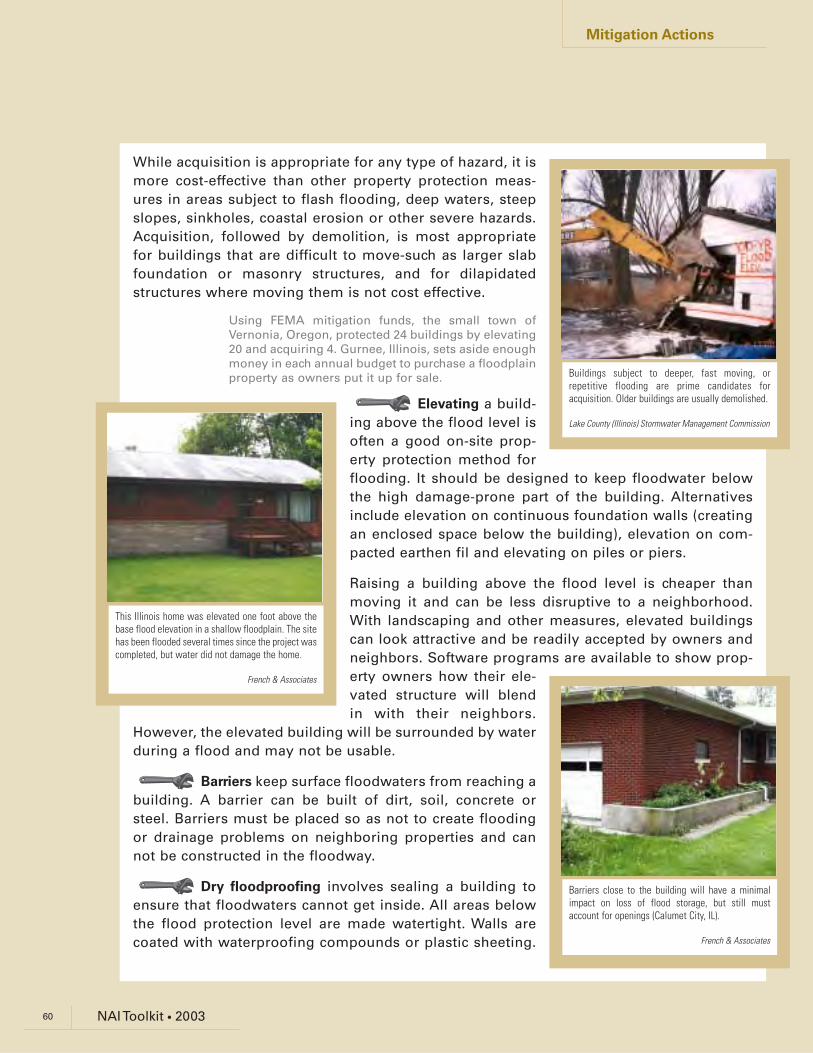
While acquisition is appropriate for any type of hazard, it ismore cost-effective than other property protection meas-ures in areas subject to flash flooding, deep waters, steepslopes, sinkholes, coastal erosion or other severe hazards.Acquisition, followed by demolition, is most appropriatefor buildings that are difficult to move-such as larger slabfoundation or masonry structures, and for dilapidatedstructures where moving them is not cost effective.
Using FEMA mitigation funds, the small town ofVernonia, Oregon, protected 24 buildings by elevating20 and acquiring 4. Gurnee, Illinois, sets aside enoughmoney in each annual budget to purchase a floodplainproperty as owners put it up for sale.
Elevating a build-ing above the flood level isoften a good on-site prop-erty protection method forflooding. It should be designed to keep floodwater belowthe high damage-prone part of the building. Alternativesinclude elevation on continuous foundation walls (creatingan enclosed space below the building), elevation on com-pacted earthen fil and elevating on piles or piers.
Raising a building above the flood level is cheaper thanmoving it and can be less disruptive to a neighborhood.With landscaping and other measures, elevated buildingscan look attractive and be readily accepted by owners andneighbors. Software programs are available to show prop-erty owners how their ele-vated structure will blendin with their neighbors.
However, the elevated building will be surrounded by waterduring a flood and may not be usable.
Barriers keep surface floodwaters from reaching abuilding. A barrier can be built of dirt, soil, concrete orsteel. Barriers must be placed so as not to create floodingor drainage problems on neighboring properties and cannot be constructed in the floodway.
Dry floodproofing involves sealing a building toensure that floodwaters cannot get inside. All areas belowthe flood protection level are made watertight. Walls arecoated with waterproofing compounds or plastic sheeting.
60 NAI Toolkit • 2003
Mitigation Actions
Barriers close to the building will have a minimalimpact on loss of flood storage, but still mustaccount for openings (Calumet City, IL).
French & Associates
This Illinois home was elevated one foot above thebase flood elevation in a shallow floodplain. The sitehas been flooded several times since the project wascompleted, but water did not damage the home.
French & Associates
Buildings subject to deeper, fast moving, orrepetitive flooding are prime candidates foracquisition. Older buildings are usually demolished.
Lake County (Illinois) Stormwater Management Commission
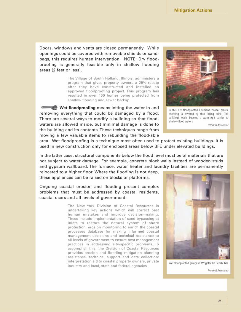
Doors, windows and vents are closed permanently. Whileopenings could be covered with removable shields or sand-bags, this requires human intervention. NOTE: Dry flood-proofing is generally feasible only in shallow floodingareas (2 feet or less).
The Village of South Holland, Illinois, administers aprogram that gives property owners a 25% rebateafter they have constructed and installed anapproved floodproofing project. This program hasresulted in over 400 homes being protected fromshallow flooding and sewer backup.
Wet floodproofing means letting the water in andremoving everything that could be damaged by a flood.There are several ways to modify a building so that flood-waters are allowed inside, but minimal damage is done tothe building and its contents. These techniques range frommoving a few valuable items to rebuilding the flood-ablearea. Wet floodproofing is a technique most often used to protect existing buildings. It isused in new construction only for enclosed areas below BFE under elevated buildings.
In the latter case, structural components below the flood level must be of materials that arenot subject to water damage. For example, concrete block walls instead of wooden studsand gypsum wallboard. The furnace, water heater and laundry facilities are permanentlyrelocated to a higher floor. Where the flooding is not deep,these appliances can be raised on blocks or platforms.
Ongoing coastal erosion and flooding present complexproblems that must be addressed by coastal residents,coastal users and all levels of government.
The New York Division of Coastal Resources isundertaking key actions which will correct pasthuman mistakes and improve decision-making.These include implementation of sand bypassing atinlets to restore the natural system of shoreprotection, erosion monitoring to enrich the coastalprocesses database for making informed coastalmanagement decisions and technical assistance toall levels of government to ensure best managementpractices in addressing site-specific problems. Toaccomplish this, the Division of Coastal Resourcesprovides erosion and flooding mitigation planningassistance, technical support and data collection/interpretation aid to coastal property owners, privateindustry and local, state and federal agencies.
61
Mitigation Actions
In this dry floodproofed Louisiana house, plasticsheeting is covered by thin facing brick. Thebuilding’s walls become a watertight barrier toshallow flood waters.
French & Associates
Wet floodproofed garage in Wrightsville Beach, NC.
French & Associates

It was explained that measures discussed under the basic level (structural flood controlprojects) can have many adverse impacts on people and natural floodplain functions.Nonstructural measures can also have concerns that need to be addressed, including:
• Acquisition/relocation is often done piecemeal, leaving what is called a checkerboardpattern of vacant lots and buildings that either didn’t qualify for the program or whoseowners did not want to move.
• Elevation and floodproofing projects still leave buildings surrounded by floodwaters dur-ing a flood. Occupants often try to ride out the flood or get to or from their propertiesduring high water, requiring police and fire protection costs.
• The building may be isolated and without utilities, therefore temporarily unusable.
• If allowed, owner-designed measures, especially dry floodproofing, may not adequatelyaccount for all forces that floodwaters place on a building. This can result in severe struc-tural damage to the building.
• The streets, utilities and other infrastructure that serve an elevated or floodproofedbuilding are still exposed to flood damage and public costs for those damages.
It’s important to remember that existing buildings should not be protected at the expenseof other properties. Don’t let your corrective actions create new flood problems.
Nonstructural measures can be accomplished or enhanced through the use of numerousNRCS programs for easements, buffers, etc. Information can be obtained from your localNRCS office or their website.
62 NAI Toolkit • 2003
Mitigation Actions
Low Impact Development Manual for Michigan
A Design Guide for Implementers and Reviewers

LID Manual for Michigan
Low Impact Development Manual for Michigan:A Design Guide for Implementors and Reviewers
SEMCOG 2008
AbstractLow Impact Development (LID) is the cornerstone of stormwater management with the goal of mimicking a site’s presettlement hydrology by using design techniques that infiltrate, filter, store, evaporate, and detain runoff close to its source. Because LID uses a variety of useful techniques for controlling runoff, designs can be customized according to local regulatory and resource protection requirements, as well as site constraints.
This manual provides communities, agencies, builders, developers, and the public with guidance on how to apply LID to new, existing, and redevelopment sites. The manual provides information on integrating LID from the community level down to the site level. It not only outlines technical details of best management practices, but also provides a larger scope of managing stormwater through policy decision, including ordinances, master plans, and watershed plans.
Funding for this project was made available by the Michigan Department of Environmental Quality through a grant from the U. S. Environmental Protection Agency. Preparation of this document may also be financed in part through grants from and in cooperation with the Michigan Department of Transportation with the assistance of the U.S. Department of Transportation’s Federal Highway Administration and Federal Transit Administration; the Michigan Department of Natural Resources with the assistance of the U.S. Environmental Protection Agency; the Michigan State Police Office of Highway Safety Planning; and local membership contributions.
-
Southeast Michigan Council of GovernmentsInformation Center535 Griswold Street, Suite 300Detroit, MI 48226-3602313-961-4266 • fax 313-961-4869www.semcog.org • [email protected]
Our Water. Our Future.
Ours to Protect
LID Manual for Michigan Page v
Table of ContentsChapter 1: Introduction . . . . . . . . . . . . . . . . . . . . . . . . . . . . . . . . . . . . . . . . . . . . . . . . . . . . . . . . . . . . . . . . . . . . . . . . . . . . . .1
Chapter 2: Stormwater Management in Michigan: Why LID? . . . . . . . . . . . . . . . . . . . . . . . . . . . . . . . . . . . . . . . . . . . . . . . .5
Chapter 3: LID in Michigan: The Key Determinants . . . . . . . . . . . . . . . . . . . . . . . . . . . . . . . . . . . . . . . . . . . . . . . . . . . . . .15
Chapter 4: Integrating LID at the Community Level. . . . . . . . . . . . . . . . . . . . . . . . . . . . . . . . . . . . . . . . . . . . . . . . . . . . . . .35
Chapter 5: Incorporating LID into the Site Design Process. . . . . . . . . . . . . . . . . . . . . . . . . . . . . . . . . . . . . . . . . . . . . . . . . .49
Chapter 6: Nonstructural Best Management Practices. . . . . . . . . . . . . . . . . . . . . . . . . . . . . . . . . . . . . . . . . . . . . . . . . . . . . .57
Cluster Development . . . . . . . . . . . . . . . . . . . . . . . . . . . . . . . . . . . . . . . . . . . . . . . . . . . . . . . . . . . . . . . . . . . . . . . . . . . . . .61
Minimize Soil Compaction . . . . . . . . . . . . . . . . . . . . . . . . . . . . . . . . . . . . . . . . . . . . . . . . . . . . . . . . . . . . . . . . . . . . . . . . .69
Minimize Total Disturbed Area . . . . . . . . . . . . . . . . . . . . . . . . . . . . . . . . . . . . . . . . . . . . . . . . . . . . . . . . . . . . . . . . . . . . . .75
Protect Natural Flow Pathways . . . . . . . . . . . . . . . . . . . . . . . . . . . . . . . . . . . . . . . . . . . . . . . . . . . . . . . . . . . . . . . . . . . . . .83
Protect Riparian Buffer Areas . . . . . . . . . . . . . . . . . . . . . . . . . . . . . . . . . . . . . . . . . . . . . . . . . . . . . . . . . . . . . . . . . . . . . . .89
Protect Sensitive Areas. . . . . . . . . . . . . . . . . . . . . . . . . . . . . . . . . . . . . . . . . . . . . . . . . . . . . . . . . . . . . . . . . . . . . . . . . . . . .97
Reduce Impervious Surfaces . . . . . . . . . . . . . . . . . . . . . . . . . . . . . . . . . . . . . . . . . . . . . . . . . . . . . . . . . . . . . . . . . . . . . . .107
Stormwater Disconnection . . . . . . . . . . . . . . . . . . . . . . . . . . . . . . . . . . . . . . . . . . . . . . . . . . . . . . . . . . . . . . . . . . . . . . . . .115
Chapter 7: Structural Best Management Practices. . . . . . . . . . . . . . . . . . . . . . . . . . . . . . . . . . . . . . . . . . . . . . . . . . . . . . . .121
Bioretention (Rain Gardens) . . . . . . . . . . . . . . . . . . . . . . . . . . . . . . . . . . . . . . . . . . . . . . . . . . . . . . . . . . . . . . . . . . . . . . .131
Capture Reuse. . . . . . . . . . . . . . . . . . . . . . . . . . . . . . . . . . . . . . . . . . . . . . . . . . . . . . . . . . . . . . . . . . . . . . . . . . . . . . . . . . .147
Constructed Filter . . . . . . . . . . . . . . . . . . . . . . . . . . . . . . . . . . . . . . . . . . . . . . . . . . . . . . . . . . . . . . . . . . . . . . . . . . . . . . .157
Detention Basins . . . . . . . . . . . . . . . . . . . . . . . . . . . . . . . . . . . . . . . . . . . . . . . . . . . . . . . . . . . . . . . . . . . . . . . . . . . . . . . .169
Infiltration Practices . . . . . . . . . . . . . . . . . . . . . . . . . . . . . . . . . . . . . . . . . . . . . . . . . . . . . . . . . . . . . . . . . . . . . . . . . . . . . .193
Level Spreaders . . . . . . . . . . . . . . . . . . . . . . . . . . . . . . . . . . . . . . . . . . . . . . . . . . . . . . . . . . . . . . . . . . . . . . . . . . . . . . . . .221
Native Revegetation . . . . . . . . . . . . . . . . . . . . . . . . . . . . . . . . . . . . . . . . . . . . . . . . . . . . . . . . . . . . . . . . . . . . . . . . . . . . .229
Pervious Pavement with Infiltration. . . . . . . . . . . . . . . . . . . . . . . . . . . . . . . . . . . . . . . . . . . . . . . . . . . . . . . . . . . . . . . . . .241
Planter Boxes . . . . . . . . . . . . . . . . . . . . . . . . . . . . . . . . . . . . . . . . . . . . . . . . . . . . . . . . . . . . . . . . . . . . . . . . . . . . . . . . . . .257
Riparian Buffer Restoration . . . . . . . . . . . . . . . . . . . . . . . . . . . . . . . . . . . . . . . . . . . . . . . . . . . . . . . . . . . . . . . . . . . . . . . .267
Soil Restoration . . . . . . . . . . . . . . . . . . . . . . . . . . . . . . . . . . . . . . . . . . . . . . . . . . . . . . . . . . . . . . . . . . . . . . . . . . . . . . . . .281
Vegetated Filter Strip . . . . . . . . . . . . . . . . . . . . . . . . . . . . . . . . . . . . . . . . . . . . . . . . . . . . . . . . . . . . . . . . . . . . . . . . . . . . .289
Vegetated Roof . . . . . . . . . . . . . . . . . . . . . . . . . . . . . . . . . . . . . . . . . . . . . . . . . . . . . . . . . . . . . . . . . . . . . . . . . . . . . . . . . .301
Vegetated Swale . . . . . . . . . . . . . . . . . . . . . . . . . . . . . . . . . . . . . . . . . . . . . . . . . . . . . . . . . . . . . . . . . . . . . . . . . . . . . . . . .315
Water Quality Devices . . . . . . . . . . . . . . . . . . . . . . . . . . . . . . . . . . . . . . . . . . . . . . . . . . . . . . . . . . . . . . . . . . . . . . . . . . . .329
Chapter 8: Implementing LID in Special Areas. . . . . . . . . . . . . . . . . . . . . . . . . . . . . . . . . . . . . . . . . . . . . . . . . . . . . . . . . .335
Chapter 9: Calculations and Methodology. . . . . . . . . . . . . . . . . . . . . . . . . . . . . . . . . . . . . . . . . . . . . . . . . . . . . . . . . . . . . .357
Chapter 10: Michigan LID Case Studies . . . . . . . . . . . . . . . . . . . . . . . . . . . . . . . . . . . . . . . . . . . . . . . . . . . . . . . . . . . . . . .387
Appendix A: Statewide LID Committee. . . . . . . . . . . . . . . . . . . . . . . . . . . . . . . . . . . . . . . . . . . . . . . . . . . . . . . . . . . . . . . .399
Appendix B: Glossary and List of Acronyms. . . . . . . . . . . . . . . . . . . . . . . . . . . . . . . . . . . . . . . . . . . . . . . . . . . . . . . . . . . .401
Appendix C: Recommended Plant Lists for Best Management Practices . . . . . . . . . . . . . . . . . . . . . . . . . . . . . . . . . . . . . .409
Appendix D: Recommended Materials. . . . . . . . . . . . . . . . . . . . . . . . . . . . . . . . . . . . . . . . . . . . . . . . . . . . . . . . . . . . . . . . .431
Appendix E: Soil Infiltration Testing Protocol . . . . . . . . . . . . . . . . . . . . . . . . . . . . . . . . . . . . . . . . . . . . . . . . . . . . . . . . . . .437
Appendix F: Maintenance Inspection Checklists . . . . . . . . . . . . . . . . . . . . . . . . . . . . . . . . . . . . . . . . . . . . . . . . . . . . . . . . .445

LID Manual for Michigan Page vi
Appendix G: Stormwater Management Practices Maintenance Agreement . . . . . . . . . . . . . . . . . . . . . . . . . . . . . . . . . . . .455
Appendix H: Model Ordinances. . . . . . . . . . . . . . . . . . . . . . . . . . . . . . . . . . . . . . . . . . . . . . . . . . . . . . . . . . . . . . . . . . . . . .463
Model LID Stormwater Ordinance . . . . . . . . . . . . . . . . . . . . . . . . . . . . . . . . . . . . . . . . . . . . . . . . . . . . . . . . . . . . . . . . . .477

LID Manual for Michigan – Chapter 5 Page 53
Step 1: Property acquisition and use analysis
Step 2: Site inventory and evaluation
Watershed factors inventory
❑ Major/minor watershed location?
❑ State stream use/standards designation/classification?
❑ Special high quality designations? (e.g., natural rivers, cold water fishery)
❑Rare or endangered species or communities present?
❑Are there required standards?
❑ Any 303d/impaired stream listing classifications?
❑ Any existing or planned Total Maximum Daily Loads (TMDLs) for the waterbody?
❑ Aquatic biota, other sampling/monitoring?
❑ Do other special fishery issues exist?
❑ Is the site linked to a special habitat system?
❑ Are there known downstream flooding problems?
❑ Are there known problems with run-on from neighboring properties?
❑ Is additional development anticipated for the area that could lead to further restrictions? (e.g., protection of downstream land and water uses)
❑ Is additional development anticipated for the area that could lead to further opportunities (e.g., partnerships in multi-site or regional water quality or quantity controls)?
Site factors inventory
❑ Important natural site features have been inventoried and mapped?
❑Wetlands?
❑Floodplains?
❑Wellhead protection areas?
❑High quality woodlands, other woodlands, and vegetation?
❑ Riparian buffers?
❑Naturally vegetated swales/drainageways?
❑Steep slopes or unique topographic features?
❑Special geologic conditions (limestone?)?
❑Historical values, certified or non-certified?
❑Known/potential archaeological values?
❑Existing hydrology (drainage swales, intermittent, perennial)?
❑Existing topography, contours?
❑Soils, their hydrologic soil groups?
❑Seasonal high water table? Depth to bedrock?
❑Special geological issues (e.g., karst)
❑Aesthetics/viewsheds?
❑Existing land cover/uses?
❑Existing impervious areas, if any?
❑Existing pervious maintained areas, if any?
❑Existing contaminants from past uses, if any?
❑Existing public sewer and water, if any?
❑Existing storm drainage system(s), if any?
❑Existing wastewater system(s), if any?
❑How does size and shape of the site affect stormwater management?
❑Are there areas where development should generally be avoided?
The site design process for LID is structured to facilitate and guide an assessment of a site’s natural features together with stormwater management needs. The LID Site Design Process Checklist will help implement the site design process. It provides guidance to the land development applicant, property owner, or builder/developer in terms of the analytical process which needs to be performed as the development proceeds. The outcome is the formulation of a LID concept for the site.
Local communities may also benefit by using this checklist for considering possible impacts to natural resources in the community and local watersheds.
Reinforcing the site design process: A site design checklist for LID

LID Manual for Michigan – Chapter 5 Page 54
Step 3: Integrate municipal, county, state, and federal requirements
Master plan
❑ Is development concept consistent with the master plan?
❑Consistent with goals/policies of the plan?
❑Preservation of natural resources consistent with priority areas/maps?
Regulations (e.g., ordinances, engineering standards)
❑Consistent with local existing regulations?
❑Wetland regulations?
❑Tree/woodlands ordinance?
❑Riparian buffer ordinance?
❑Open space requirements?
❑Clustering and/or PUD options?
❑Overlay districts?
❑Wellhead protection?
❑Floodplain ordinances?
❑Are LID solutions required?
❑or incentivized?
❑or enabled?
❑or prohibited?
❑Reduced building setbacks allowed?
❑Curbs required?
❑Swales allowed?
❑Street width, parking requirements, other impervious requirements?
❑Grading requirements?
❑Landscaping that allows native vegetation?
❑Stormwater requirements?
❑Peak rate?
❑Total runoff volume?
❑Water quality provisions?
❑Maintenance requirements?
❑Consistent with county/state road requirements?
❑Consistent with local stormwater regulations?
❑Consistent with erosion and sedimentation requirements?
❑Contaminated sites have followed state “due care” requirements for soil and groundwater?
❑Consistent with state and federal wetland and/or inland lakes and streams regulations?
❑Consistent with state threatened and endangered species regulations?
❑Meets state floodplain requirements?
Step 4: Develop initial concept design using nonstructural BMPs
Lot configuration and clustering?
❑Reduced individual lot size?
❑Concentrated/clustered uses and lots?
❑Lots/development configured to avoid critical natural areas?
❑Lots/development configured to take advantage of effective mitigative stormwater practices?
❑Lots/development configured to fit natural topography?
❑Connect open space/sensitive areas with larger community greenways plan?
Minimum disturbance?
❑Define disturbance zones (excavation/grading) for site?
❑Protect maximum total site area from development disturbance?
❑Barriers/flagging proposed to protect designated non-disturbance areas?
❑Disturbance setbacks defined from BMP areas, vegetated areas, tree drip lines, etc.?
❑Site disturbance (excavation/grading) minimized for each lot?
❑Considered mitigative practices for minimal disturbance areas (e.g., Soil Restoration)
❑Considered re-forestation and re-vegetation opportunities?
Impervious coverage reduced?
❑Reduced road width?
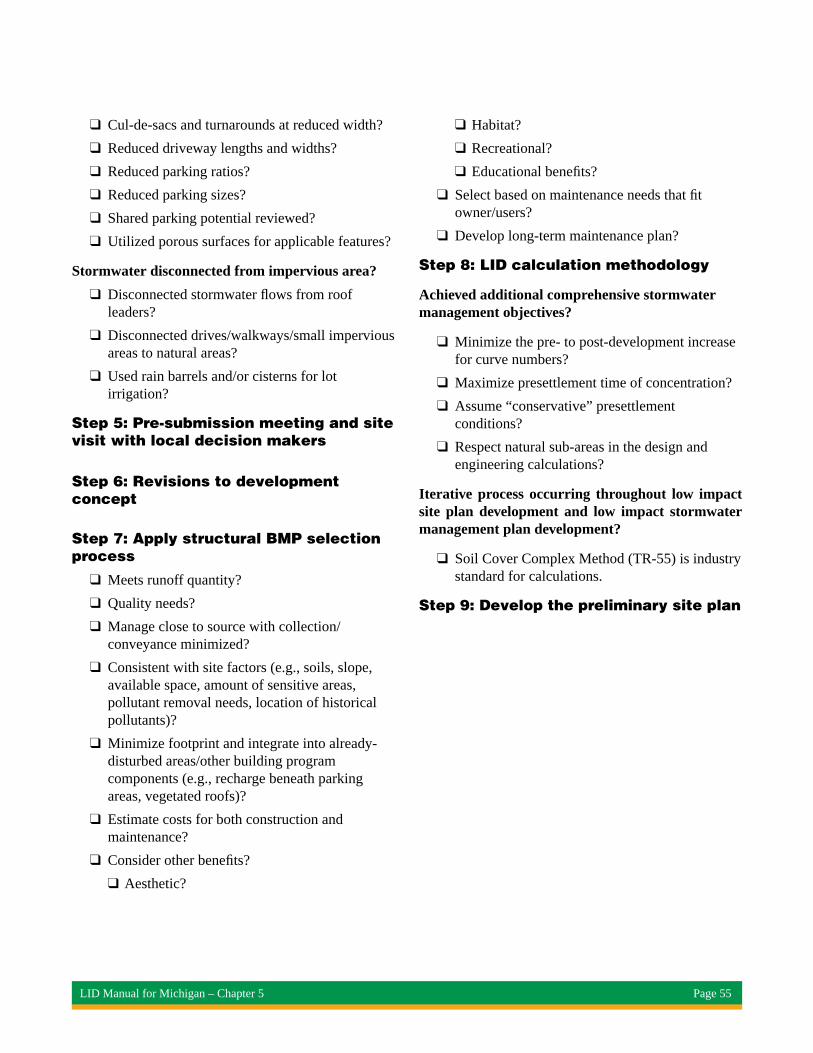
LID Manual for Michigan – Chapter 5 Page 55
❑Cul-de-sacs and turnarounds at reduced width?
❑Reduced driveway lengths and widths?
❑Reduced parking ratios?
❑Reduced parking sizes?
❑Shared parking potential reviewed?
❑Utilized porous surfaces for applicable features?
Stormwater disconnected from impervious area?
❑Disconnected stormwater flows from roof leaders?
❑Disconnected drives/walkways/small impervious areas to natural areas?
❑Used rain barrels and/or cisterns for lot irrigation?
Step 5: Pre-submission meeting and site visit with local decision makers
Step 6: Revisions to development concept
Step 7: Apply structural BMP selection process
❑Meets runoff quantity?
❑Quality needs?
❑Manage close to source with collection/conveyance minimized?
❑Consistent with site factors (e.g., soils, slope, available space, amount of sensitive areas, pollutant removal needs, location of historical pollutants)?
❑Minimize footprint and integrate into already-disturbed areas/other building program components (e.g., recharge beneath parking areas, vegetated roofs)?
❑Estimate costs for both construction and maintenance?
❑Consider other benefits?
❑Aesthetic?
❑Habitat?
❑Recreational?
❑Educational benefits?
❑Select based on maintenance needs that fit owner/users?
❑Develop long-term maintenance plan?
Step 8: LID calculation methodology
Achieved additional comprehensive stormwater management objectives?
❑Minimize the pre- to post-development increase for curve numbers?
❑Maximize presettlement time of concentration?
❑Assume “conservative” presettlement conditions?
❑Respect natural sub-areas in the design and engineering calculations?
Iterative process occurring throughout low impact site plan development and low impact stormwater management plan development?
❑Soil Cover Complex Method (TR-55) is industry standard for calculations.
Step 9: Develop the preliminary site plan

1 Appendix B: Other Resources Building Coastal Resiliency in the City of Grand Haven
MODEL ORDINANCE LINKS This document was created to provide links to model and adopted ordinances currently in use by coastal communities. The list is organized by topic area, and includes a number of policy options referred to in Chapters 2, 3, and 4 of the final report.
GENERAL MODEL ORDINANCE INFORMATION • Michigan Coastal Community Working Waterfronts: Best Practices. Michigan Sea Grant – University of
Michigan. http://www.miseagrant.umich.edu/wp-content/blogs.dir/1/files/2013/08/13-720-Best-Practices-Working-Waterfronts-Case-Study.pdf
• Coastal & Waterfront Smart Growth. NOAA. United States Department of Commerce. http://coastalsmartgrowth.noaa.gov/welcome.html
• Rural Water Quality Protection: A Planning & Zoning Guidebook for Local Officials. Warbach, J. et al. Michigan State University – Land Use Policy Institute. http://landpolicy.msu.edu/resources/rural_water_quality_protection_a_planning_zoning_guidebook_for_local_offici
• A Model County Shoreland Zoning Ordinance for Wisconsin’s Shoreland Protection Program. Wisconsin Department of Natural Resources. http://dnr.wi.gov/topic/ShorelandZoning/documents/NR115ModelOrdinance.pdf
• Ohio Coastal Management Program Issue Areas and Policies. Ohio Department of Natural Resources Office of Coastal Management. http://coastal.ohiodnr.gov/ocmp
• Resilient Coastal Development Through Land Use Planning: Tools & Management Techniques in the Gulf of Mexico. Pace, N. Mississippi-Alabama Sea Grant Legal Program, University of Mississippi School of Law. http://seagrant.noaa.gov/Portals/0/Documents/what_we_do/social_science/ss_tools_reports/resilient-planning_web.pdf
AGRICULUTURAL BUFFERS • Agricultural Buffer Requirements. Georgia Department of Community Affairs.
http://www.dca.state.ga.us/intra_nonpub/Toolkit/ModelOrdinances/AltZ/4_3.pdf
FLORISTIC QUALITY INDEX • Spring Lake Township, Ottawa County, Michigan. Chapter 14: Environment; Article V. Wetland
Protection. https://www.municode.com/library/mi/spring_lake_township,_ottawa_co/codes/code_of_ordinances?nodeId=COOR_CH14EN_ARTVWEPR_S14-107FIFA
• Development of a Floristic Quality Assessment Methodology for Wisconsin. Wisconsin Department of Natural Resources, Bureau of Fisheries Management and Habitat Protection. http://dnr.wi.gov/topic/wetlands/documents/fqamethodwithacknowledgements.pdf
• Floristic Quality Assessment with Wetland Categories and Examples of Computer Applications for the State of Michigan. Michigan Department of Natural Resources Wildlife Division. http://www.michigandnr.com/publications/pdfs/huntingwildlifehabitat/FQA_text.pdf
• Properties and Performance of the Floristic Quality Index in Great Lakes Coastal Wetlands. Bourdaghs, M. et al. Center for Water and the Environment Natural Resources Research Institute, University of Minnesota Duluth. http://www.sustainourgreatlakes.org/wp-content/uploads/Properties-and-Performance-of-the-Floristic-Quality-Index-in-Great-Lakes-Coastal-Wetlands.pdf
• The Use of Floristic Quality Assessment as a Tool for Monitoring Wetland Mitigations in Michigan. Smit Deboer, L. et al. The Michigan Botanist. Vol. 50. http://quod.lib.umich.edu/cgi/p/pod/dod-idx/use-of-floristic-quality-assessment-as-a-tool-for-monitoring.pdf?c=mbot;idno=0497763.0050.402
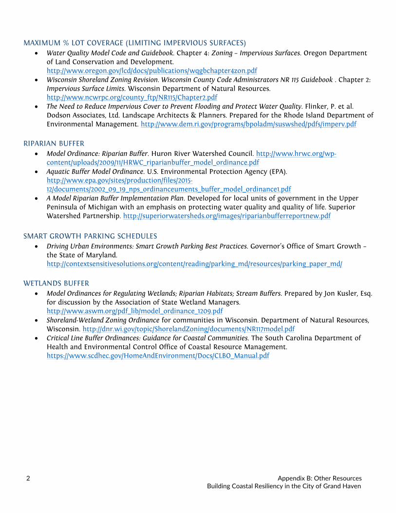
2 Appendix B: Other Resources Building Coastal Resiliency in the City of Grand Haven
MAXIMUM % LOT COVERAGE (LIMITING IMPERVIOUS SURFACES) • Water Quality Model Code and Guidebook. Chapter 4: Zoning – Impervious Surfaces. Oregon Department
of Land Conservation and Development. http://www.oregon.gov/lcd/docs/publications/wqgbchapter4zon.pdf
• Wisconsin Shoreland Zoning Revision. Wisconsin County Code Administrators NR 115 Guidebook . Chapter 2: Impervious Surface Limits. Wisconsin Department of Natural Resources. http://www.ncwrpc.org/county_ftp/NR115/Chapter2.pdf
• The Need to Reduce Impervious Cover to Prevent Flooding and Protect Water Quality. Flinker, P. et al. Dodson Associates, Ltd. Landscape Architects & Planners. Prepared for the Rhode Island Department of Environmental Management. http://www.dem.ri.gov/programs/bpoladm/suswshed/pdfs/imperv.pdf
RIPARIAN BUFFER • Model Ordinance: Riparian Buffer. Huron River Watershed Council. http://www.hrwc.org/wp-
content/uploads/2009/11/HRWC_riparianbuffer_model_ordinance.pdf • Aquatic Buffer Model Ordinance. U.S. Environmental Protection Agency (EPA).
http://www.epa.gov/sites/production/files/2015-12/documents/2002_09_19_nps_ordinanceuments_buffer_model_ordinance1.pdf
• A Model Riparian Buffer Implementation Plan. Developed for local units of government in the Upper Peninsula of Michigan with an emphasis on protecting water quality and quality of life. Superior Watershed Partnership. http://superiorwatersheds.org/images/riparianbufferreportnew.pdf
SMART GROWTH PARKING SCHEDULES
• Driving Urban Environments: Smart Growth Parking Best Practices. Governor’s Office of Smart Growth – the State of Maryland. http://contextsensitivesolutions.org/content/reading/parking_md/resources/parking_paper_md/
WETLANDS BUFFER • Model Ordinances for Regulating Wetlands; Riparian Habitats; Stream Buffers. Prepared by Jon Kusler, Esq.
for discussion by the Association of State Wetland Managers. http://www.aswm.org/pdf_lib/model_ordinance_1209.pdf
• Shoreland-Wetland Zoning Ordinance for communities in Wisconsin. Department of Natural Resources, Wisconsin. http://dnr.wi.gov/topic/ShorelandZoning/documents/NR117model.pdf
• Critical Line Buffer Ordinances: Guidance for Coastal Communities. The South Carolina Department of Health and Environmental Control Office of Coastal Resource Management. https://www.scdhec.gov/HomeAndEnvironment/Docs/CLBO_Manual.pdf