Embed Size (px)
Citation preview
This project has been funded by
the German Federal Agency for Nature Conservation (BfN)
with funds of the German Federal Ministry for the Environment,
Nature Conservation and Nuclear Safety and by the
German Federal Foundation for Environment Protection (DBU).
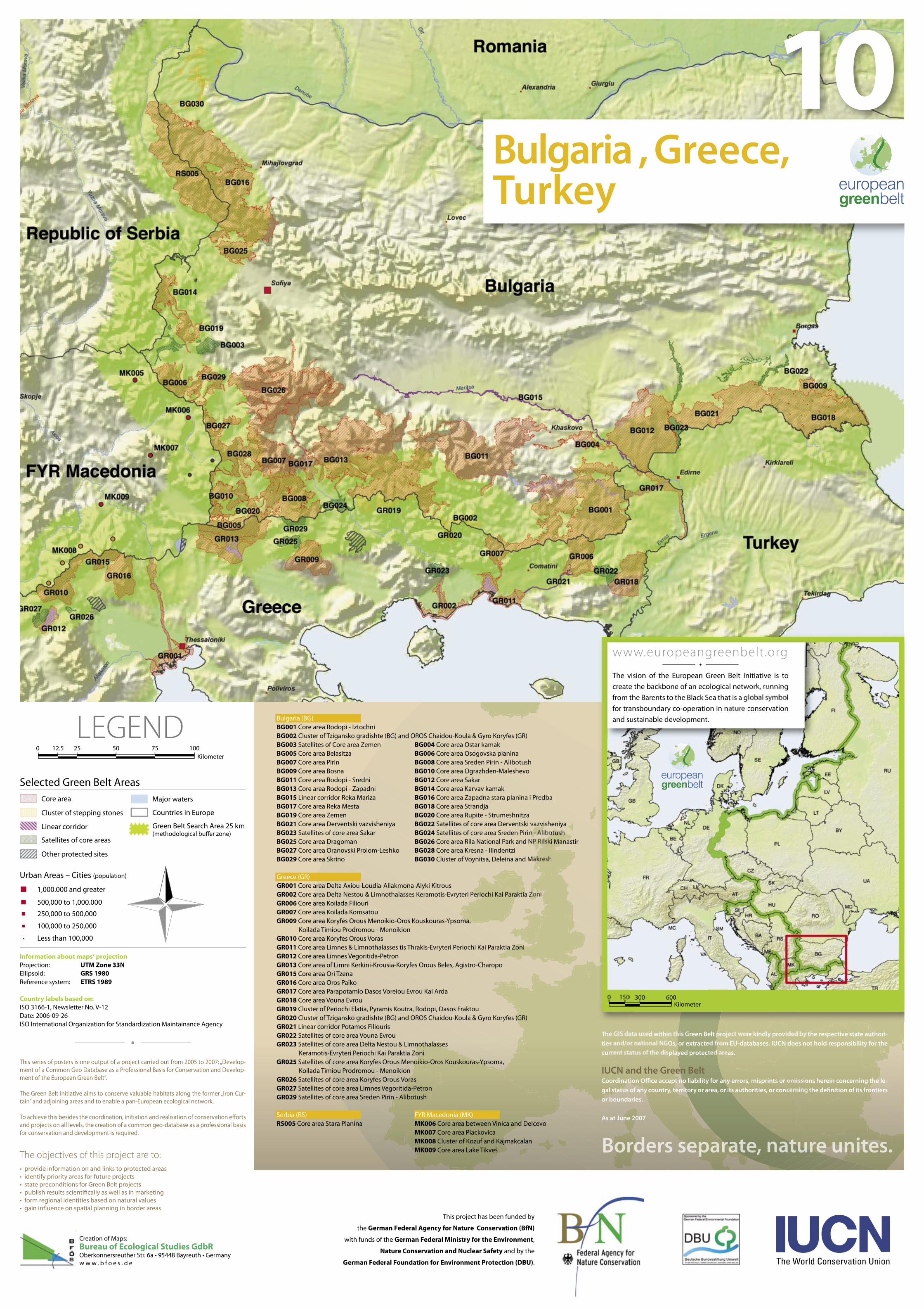
10
Kilometer0 12.5 25 50 75 100
Bulgaria , Greece,Turkey
Information about maps‘ projectionProjection: UTM Zone 33NEllipsoid: GRS 1980Reference system: ETRS 1989
Country labels based on:ISO 3166-1, Newsletter No. V-12Date: 2006-09-26ISO International Organization for Standardization Maintainance Agency
Major waters
Countries in Europe
Green Belt Search Area 25 km(methodological buffer zone)
Core area
Cluster of stepping stones
Linear corridor
Satellites of core areas
Other protected sites
1,000.000 and greater
500,000 to 1,000.000
250,000 to 500,000
100,000 to 250,000
Less than 100,000
Urban Areas – Cities (population)
LEGEND
Selected Green Belt Areas
Bulgaria (BG)BG001 Core area Rodopi - IztochniBG002 Cluster of Tzigansko gradishte (BG) and OROS Chaidou-Koula & Gyro Koryfes (GR)BG003 Satellites of Core area Zemen BG004 Core area Ostar kamakBG005 Core area Belasitza BG006 Core area Osogovska planinaBG007 Core area Pirin BG008 Core area Sreden Pirin - AlibotushBG009 Core area Bosna BG010 Core area Ograzhden-Maleshevo BG011 Core area Rodopi - Sredni BG012 Core area SakarBG013 Core area Rodopi - Zapadni BG014 Core area Karvav kamakBG015 Linear corridor Reka Mariza BG016 Core area Zapadna stara planina i PredbaBG017 Core area Reka Mesta BG018 Core area StrandjaBG019 Core area Zemen BG020 Core area Rupite - StrumeshnitzaBG021 Core area Derventski vazvisheniya BG022 Satellites of core area Derventski vazvisheniyaBG023 Satellites of core area Sakar BG024 Satellites of core area Sreden Pirin - AlibotushBG025 Core area Dragoman BG026 Core area Rila National Park and NP Rilski ManastirBG027 Core area Oranovski Prolom-Leshko BG028 Core area Kresna - IlindentziBG029 Core area Skrino BG030 Cluster of Voynitsa, Deleina and Makresh
Greece (GR)GR001 Core area Delta Axiou-Loudia-Aliakmona-Alyki KitrousGR002 Core area Delta Nestou & Limnothalasses Keramotis-Evryteri Periochi Kai Paraktia ZoniGR006 Core area Koilada FiliouriGR007 Core area Koilada KomsatouGR009 Core area Koryfes Orous Menoikio-Oros Kouskouras-Ypsoma,
Koilada Timiou Prodromou - MenoikionGR010 Core area Koryfes Orous VorasGR011 Core area Limnes & Limnothalasses tis Thrakis-Evryteri Periochi Kai Paraktia ZoniGR012 Core area Limnes Vegoritida-PetronGR013 Core area of Limni Kerkini-Krousia-Koryfes Orous Beles, Agistro-CharopoGR015 Core area Ori TzenaGR016 Core area Oros PaikoGR017 Core area Parapotamio Dasos Voreiou Evrou Kai ArdaGR018 Core area Vouna EvrouGR019 Cluster of Periochi Elatia, Pyramis Koutra, Rodopi, Dasos FraktouGR020 Cluster of Tzigansko gradishte (BG) and OROS Chaidou-Koula & Gyro Koryfes (GR)GR021 Linear corridor Potamos FiliourisGR022 Satellites of core area Vouna EvrouGR023 Satellites of core area Delta Nestou & Limnothalasses
Keramotis-Evryteri Periochi Kai Paraktia ZoniGR025 Satellites of core area Koryfes Orous Menoikio-Oros Kouskouras-Ypsoma,
Koilada Timiou Prodromou - MenoikionGR026 Satellites of core area Koryfes Orous VorasGR027 Satellites of core area Limnes Vegoritida-PetronGR029 Satellites of core area Sreden Pirin - Alibotush
Serbia (RS) FYR Macedonia (MK)RS005 Core area Stara Planina MK006 Core area between Vinica and Delcevo MK007 Core area Plackovica MK008 Cluster of Kozuf and Kajmakcalan MK009 Core area Lake Tikveš
This series of posters is one output of a project carried out from 2005 to 2007: „Develop-ment of a Common Geo Database as a Professional Basis for Conservation and Develop-ment of the European Green Belt“.
The Green Belt initiative aims to conserve valuable habitats along the former „Iron Cur-tain” and adjoining areas and to enable a pan-European ecological network.
To achieve this besides the coordination, initiation and realisation of conservation efforts and projects on all levels, the creation of a common geo-database as a professional basis for conservation and development is required.
• provide information on and links to protected areas• identify priority areas for future projects• state preconditions for Green Belt projects• publish results scientifically as well as in marketing• form regional identities based on natural values• gain influence on spatial planning in border areas
The objectives of this project are to:Borders separate, nature unites.Borders separate, nature unites.Borders separate, nature unites.Borders separate, nature unites.Borders separate, nature unites.Borders separate, nature unites.Borders separate, nature unites.Borders separate, nature unites.Borders separate, nature unites.Borders separate, nature unites.Borders separate, nature unites.Borders separate, nature unites.Borders separate, nature unites.Borders separate, nature unites.Borders separate, nature unites.Borders separate, nature unites.Borders separate, nature unites.Borders separate, nature unites.Borders separate, nature unites.Borders separate, nature unites.Borders separate, nature unites.Borders separate, nature unites.Borders separate, nature unites.Borders separate, nature unites.Borders separate, nature unites.Borders separate, nature unites.Borders separate, nature unites.Borders separate, nature unites.Borders separate, nature unites.Borders separate, nature unites.Borders separate, nature unites.Borders separate, nature unites.Borders separate, nature unites.Borders separate, nature unites.Borders separate, nature unites.Borders separate, nature unites.Borders separate, nature unites.Borders separate, nature unites.Borders separate, nature unites.Borders separate, nature unites.
The GIS data used within this Green Belt project were kindly provided by the respective state authori-ties and/or national NGOs, or extracted from EU-databases. IUCN does not hold responsibility for the current status of the displayed protected areas.
IUCN and the Green Belt Coordination Office accept no liability for any errors, misprints or omissions herein concerning the le-gal status of any country, territory or area, or its authorities, or concerning the definition of its frontiers or boundaries.
As at June 2007
The vision of the European Green Belt Initiative is to
create the backbone of an ecological network, running
from the Barents to the Black Sea that is a global symbol
for transboundary co-operation in nature conservation
and sustainable development.
www.europeangreenbelt.org
Kilometer0 150 300 600
Creation of Maps:Bureau of Ecological Studies GdbROberkonnersreuther Str. 6a • 95448 Bayreuth • Germanyw w w . b f o e s . d e


![Civil-Military Relations [Greece & Turkey]](https://img.pdfslide.net/doc/110x75/55cf9db0550346d033aeb855/civil-military-relations-greece-turkey.jpg)